Geography for Trinidad and Tobago Forms

1, 2 & 3
Editors: Eartha Thomas Hunte, Jason Manswell
Contents Unit 1 Exploring the World 4 Unit 2 Boundaries and Borders 8 Unit 3 Locating Places 14 Unit 4 The Caribbean Region 16 Unit 5 Building Map Skills 19 Fieldwork 1 26 Unit 6 The Physical Environment 27 Unit 7 The Human Environment and Population 30 Unit 8 Physical Landforms/Features and Human Land-Use 34 Fieldwork 2 37 Unit 9 Earth’s Structure 39 Unit 10 Earth’s Natural Disasters 41 Unit 11 Weather and Climate 46 Fieldwork 3 50 Unit 12 Our Environment 53 SamplePages
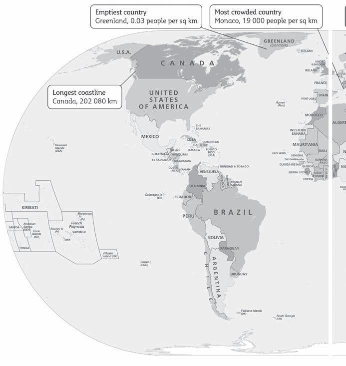
1 Look at the map of the world below, then answer the questions.

a) Mark on the map the names of the continents and oceans and at least one desert, mountain and river.
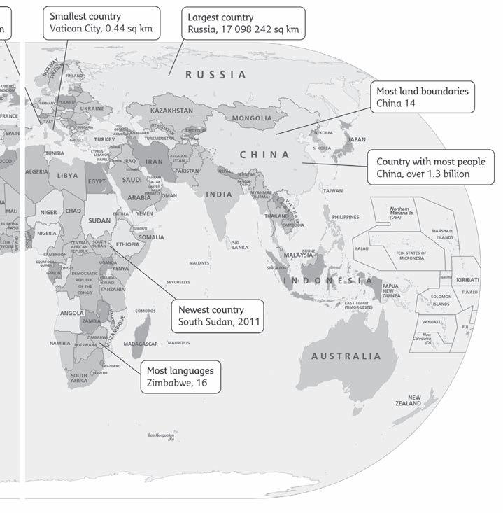
b) In which country are the most languages spoken?
c) Which country is the smallest in the world?
SamplePages
d) Which country has the least number of people per square kilometre?
e) Which country has the most land boundaries?
4 1 Exploring
the World
f) Name the newest country.
g) Which country has the most people?
1 Exploring the World (cont.)
2 Complete the facts about Trinidad and Tobago. Use the internet to research any information you are not sure about.
Continent
Population size
Official languages
Main religions
Main ethnic groups
The name of the national anthem
The national symbol
Currency
3 Complete the crossword. All the words can be found in 1.1–2.3 in the Student’s Book.
6
12 3 45 6 78 9 10 11 12 13 14 15 16
SamplePages
1. a large body of land, such as a continent (8)
3. a country that is adjacent or next to another country or shares its borders (9, 5)
5. a group of people with the authority to govern a country (10)
6. a 3D map of the world (5)
7. a design or object that is a symbol of a country (6)
9. Asian country that borders Pakistan (5)
11. a geographical landform or part of the environment, such as a mountain or river (7)
12. a stream that feeds into a larger river (9)
13. the place where a river starts, usually in a mountain or hill (6)
16. an outline or dividing line; a line that encloses a given area (8)
Down
2. the idea of a nation as a whole; having a shared culture, language or any other shared traits contained in its history (8, 8)
4. one of the large, continuous expanses of land on Earth, such as South America (9)
8. a picture that shows an area of the Earth as seen from above, showing either physical or political features (3)
10. a grouping of people with common national or cultural traditions (9)
14. an examination and record of an area of land, in order to create an accurate plan or description (6)
15. a country surrounded by other countries (10)
16. edge of a country or a line separating two countries or regions (6)
7
Across
SamplePages


