ACKNOWLEDGEMENTS
The assistance of the following people is gratefully acknowledged in the development of this plan:
Dave Badman Eccleston George
Ian Boyd Arc Consulting / Artecology
John Brownscombe Isle of Wight Gardens Trust
Lee Byrne Conservation Officer, Isle of Wight Council
Charlotte Corney Brown’s (IOW) Ltd
John Deacon Site Manager, Brown’s Family Golf
Nigel George Eccleston George / Artecology
Claire Hector Arc Consulting / Artecology
John Helps Sandown Men in Sheds
Alex Kennedy Great grandson of Mr Alexander Kennedy
Becky Loader County Archaeologist, Isle of Wight Council
Jacky MacDonald Great granddaughter of Mr Alexander Kennedy
Derek Poole Sandown and District Historical Society
Trevor Price Community Learning Officer, Dinosaur Isle
Richard Smout Head of Heritage Services, Isle of Wight Council
Brown’s Golf Course, Sandown Conservation Management Plan March 2020 6
1.0 INTRODUCTION
1.1 Background
This Conservation Management Plan (CMP) has been prepared by Pete Fellows as part of Ice Cream and Science, a Coastal Revival Fund project to explore options for the regeneration of Brown’s Golf Course. It has been produced in accordance with Historic England and National Lottery Heritage Fund guidance
1.2 Purpose and scope
The purpose of the CMP is to provide a baseline and consolidated understanding of the historic, cultural and natural heritage of the site, its significance, and the possible threats to it. Together these are intended to assist in the preparation of strategic management and development plans that will:
• inform day-to-day and long-term management;
• inform strategies for conservation and enhancement;
• provide a basis for improving facilities and widening use;
• support applications for capital funding for repair and enhancement
1.3 Structure
The Plan is set out in four main sections together with a gazetteer as an appendix.
Understanding the Asset
This provides a summary of the key information known about Brown’s Golf Course. It sets out their geographical context, existing structure and fabric, the main phases of historical development, current management and current use.
Statement of Significance
This section seeks to assess what is important about the site, why it is worthy of conservation and levels of significance overall and for its individual elements.
Risks and opportunities
This section identifies the key challenges within the site and puts forward suggestions for how these may be resolved
Policies and objectives
There are broad, overarching statements of purpose for the long-term management of the site. These are followed by more specific short-term objectives.
The Gazetteer
This provides information about the site on an area by area basis so that for each major element there is a concise statement of understanding, significance, issues and policy.
Brown’s Golf Course, Sandown Conservation Management Plan March 2020 7
2.0 UNDERSTANDING THE ASSET
2.1 Baseline information Definition
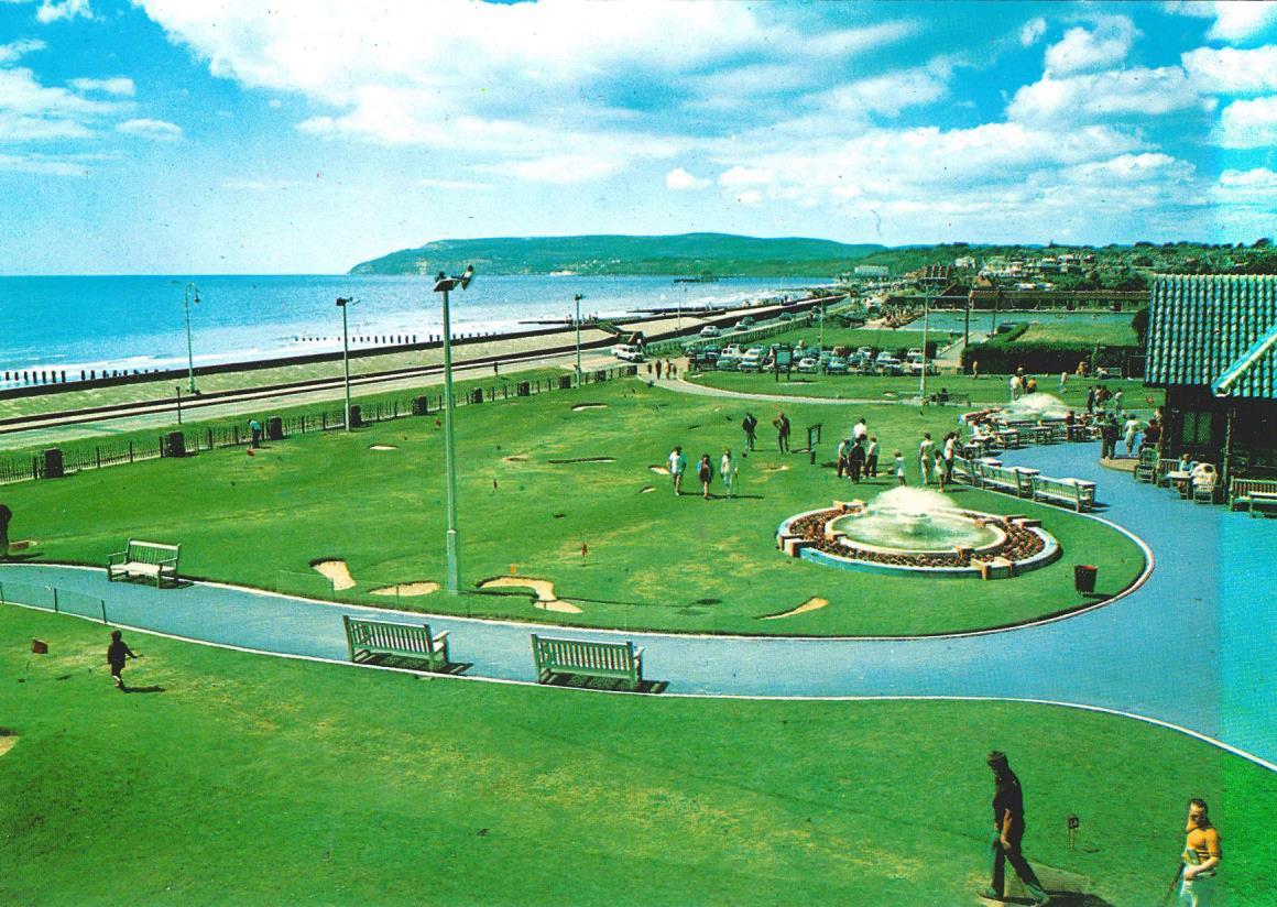
For the purposes of this plan Brown’s describes the 7.5 hectare site on Sandown seafront substantially laid out as a pitch and putt golf course, [Map 1]. It comprises:
• 1 x 18-hole ‘short’ putting course – the White Course;
• 1 x 18-hole ‘long’ putting course – the Blue Course;
• 1 x 9-hole pitch and putt course – the Red Course;
• 1 x 9-hole pitch and putt course – the Yellow Course;
• Clubhouse and Cafe Pavilion;
• Car park;
• Greenkeepers yard;
• ‘PLUTO’ Power House;
• Former Ice Cream Factory and store
Map 1 - Brown’s Golf Course shaded grey (http://wightnet.iow.gov.uk. Accessed 12/12/19)

Location and setting
Brown’s is located on the south-east coast of the Isle Wight. It sits between the resort town of Sandown and hamlet of Yaverland on the B3395 Culver Parade at the northern end of Sandown Bay. It shares boundaries with Sandown Levels marshland, the derelict Grand Hotel, Culver Parade and Dinosaur Isle Museum to the north, east, south and west respectively
Brown’s Golf Course, Sandown Conservation Management Plan March 2020 8
Local context
Brown’s is close to a number of cultural and natural assets,[Map 2]. They include:
East
• 19th century Granite Fort owned by the Wildheart Trust and operated as the Isle of Wight Zoo;
• 19th century Yaverland Battery, a Scheduled Monument
• 19th century Bembridge Fort, a Scheduled Monument owned by the National Trust
• Bembridge Down, a Site of Special Scientific Interest owned by the National Trust which is wholly within the Isle of Wight Area of Outstanding Natural Beauty
North
• Sandown Levels, a Site of Importance for Nature Conservation owned by the Isle of Wight Council (IWC);

South
• Sandown Bay which forms part of the South Wight Maritime Special Area of Conservation; West
• the IWC owned Dinosaur Isle Museum which holds the Isle of Wight Geology Museum, a collection accredited with the Arts Council of England;
• Sandham Gardens, owned by Sandown Town Council and run as a leisure park by commercial operator, Heritage Great Britain.
Brown’s Golf Course, Sandown Conservation Management Plan March 2020 9
Map 2 – Brown’s in context
(http://wightnet.iow.gov.uk. Accessed 12/12/19)
Topography
Brown’s occupies a low-lying area with much of the site forming a part of the River Yar floodplain. Its gently rolling topography has elevations ranging between 5m AOD in its south east corner to 5m AOD on its north and west boundaries.1
Geology
The underlying geology is Wealden Group to a depth of some 3-4 metres. Sediment analysis also points to the site lying on the course of a remnant inactive river or stream channel from the early Holocene period.2
Climate
The area enjoys a mild and reasonably dry climate. Average monthly temperatures range from a high of 20° in July to a low of 7° in February whilst average annual rainfall is 8708mm per annum The prevailing winds are south-westerly 3
Ownership
Freehold ownership of the site is held by the IWC. It is let to Brown’s (IOW) Ltd on a 25-year lease commencing 2011 4 It is understood the lease agreement includes a break clause operable by the tenant at any time after 11 April 2018. This clause is subject to notice of at least 12 months, with such notice expiring during the winter months November to February.
Designations
The ‘PLUTO’ Power House is listed by Historic England at Grade II for its historic and architectural interest.5
The entire site is located within the Isle of Wight UNESCO Biosphere Reserve.
Access
Brown’s lies approximately 1km to the east of Sandown town centre along the B3395 Culver Parade. It is accessed from Culver Parade by two footpaths which lead to the Clubhouse. Vehicular access to the site car park is via a spur road from Culver Parade. An hourly bus service connects the site with Sandown, Newport and Ryde. In the summer months it is served by the open-top ‘Downs Breezer’ bus. The nearest train station is 1.5km away at Sandown.
Current use
Brown’s is the principal green space on Sandown seafront and accommodates a range of formal and informal recreational uses. Foremost of these is golf, with two putting courses and two pitch and putt courses which are generally open to the paying public to play from March to October.
1 www.freemaptools.com/elevation-finder.htm Accessed 10/5/19
2 Palaeo-environmental Study Area P5 Sandown Bay and Brading Haven. (2010) pp 2
3 www.metoffice.gov.uk Accessed 10/5/19
4 This is a different body to the Wildheart Trust which currently operates the IW Zoo.
5 www.historicengland.org.uk/listing/the-list/list-entry/1391723. Accessed 15/5/19
Brown’s Golf Course, Sandown Conservation Management Plan March 2020 10
The Clubhouse Pavilion is a popular day-time destination cafe in its own right, [Fig. 2] and hosts regular evening ‘Campfire Sessions’ which give a platform to local musicians, [Fig. 3]. In recent years it has also established itself as an important venue for a range of not-for profit community activities. This includes: Hullabaloo, a large-scale outdoor celebration of art and science, [Fig. 4]; Discovery Bay, an annual programme of public activities exploring and celebrating the Bay area’s natural environment; Sandown 10Km and events run by the local Classic Car Society.


The PLUTO Power House provides a base for Sandown’s ‘Men in Sheds’ who, meet on a weekly basis to work on the restoration of its machinery, fixtures and fittings
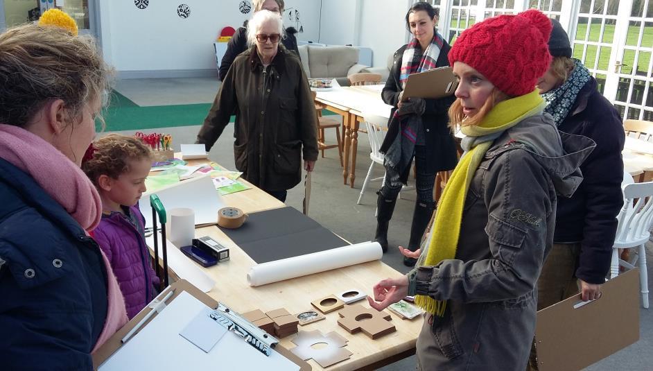
The offices and studios within the former Ice Cream Factory accommodate a number of small businesses including Arc Consulting, Artecology, Eccleston George, Hannah George Makings and The Common Space. The pioneering work of these organisations in the design and application of bio-resilient materials has seen the site become a focus for visiting university students and academics.

Brown’s Golf Course, Sandown Conservation Management Plan March 2020 11
Fig 1 – Brown’s Family Golf logo Fig 2 – Inside the Clubhouse café, 2016 (John Deacon)
Fig 3 – Campfire Session, 2017 (Julian Winslow) Fig 4 – Hullaballoo, 2018 (Julian Winslow)
2.2 Character Areas
To ease description and referencing in the proceeding sections the site is divided into four character areas based on their structure, features and use, [Map 3]
Area A - Clubhouse and White Course

‘Area A’ is the gateway to and operational hub of the site covering an area of approximately 1 hectare It is dominated by the 1930s timber clad Clubhouse Pavilion which, with its distinctive blue-glazed tile roof and large glazed conservatory, sits at the centre of the area, [Figs. 5&6].


Brown’s Golf Course, Sandown Conservation Management Plan March 2020 12
Map 3 – Brown’s ‘Character Areas’ (http://wightnet.iow.gov.uk Accessed 12/12/19)
Fig 5 – Brown’s Clubhouse east elevation, 2019 (Author’s own)
Fig 6 – Brown’s Clubhouse west elevation, 2019 (Author’s own)
The 18-hole ‘short’ putting course - the White Course, with its twin glazed fountains, now used as planters, is laid out to the south of the Clubhouse and forms the site’s boundary with Culver Parade Ten redundant floodlight pylons loom over the White Course and Clubhouse. Two winding tarmac footpaths provide pedestrian access to the Clubhouse from Culver Parade at the south-east and south-west corners of the White Course. A gravel car park with a capacity for about 20 cars is laid out to the west of the Clubhouse with a fenced storage area on its north-west corner Located approximately 50m to the east of the Clubhouse is the former Ice Cream Factory and store. It is formed of three contiguous structures, a two-storey block (including a brick storage shed), and a single storey block respectively linked by an enclosed yard. The former Ice Cream Factory is now used as artist studios and the store as office space, [Fig. 7].
Area B – Blue Course
To the north of the Clubhouse is the site’s 18-hole ‘long’ putting course - the Blue Course covering an area of approximately 1½ hectares, [Fig. 9] On its western boundary is a municipal car park from which it is separated by a low picket fence. The eastern boundary is marked by a dilapidated post and wire fence and a line of poplars beyond which lie the grounds of the derelict Grand Hotel. A prominent line of wind-shaped trees form a loose northern boundary to this area, [Fig. 10]


Brown’s Golf Course, Sandown Conservation Management Plan March 2020 13
Fig 7 – Former Ice Cream Factory and store, 2019 (Author’s own)
Fig 8 – Looking north-west across Area A, 2019 (Author’s own)
Fig 9 – Blue Course with Brading Downs in the distance, 2019 (Author’s own)
Fig 10 – Tree line marking northern boundary of Blue Course, 2019 (Author’s own)
Each of the 18 holes consist of a teeing ground, a fairway, averaging 20-30 metres in length, and a green, averaging approximately 10 metres in diameter, with a flagstick and hole. The closely cut grass on the fairways and greens set them apart from the remainder of the course namely the rough – areas of longer grass - and the hazards - low grass covered cushions of earth which contribute to the area’s gently undulating topography. This area offers superb views south across the Bay and north towards Brading Down

Area C – Red and Yellow Courses
Area C covers just over half of the total area of Brown’s, approximately 4 hectares, and is the location for the Red and Yellow 9-hole pitch and putt courses With holes typically measuring up to 80m in length the two courses offer a sterner challenge for players than the 18-hole putting course in Area B Each hole comprises teeing grounds closely cropped fairways, greens, grass covered pillow mounds and shallow hollows. The most striking feature of this area is the 8th hole of the Red course which remains the centrepiece of Henry Cotton’s original design. It comprises a raised, open-sided teeing off hut and a green constructed in the shape of the Isle of Wight, complete with the iconic Needles and a water hazard representing the coastal fringe, [Figs. 11 & 12]. Both remain largely true to their 1930s design albeit the water hazard has not held water since the 1970s.
This area has an open aspect with largely unbroken views in most directions, [Fig. 13]. The north and east boundary with Sandown Levels is formed by hedgerows and scrubby woodland of blackthorn, hawthorn and willow interspersed with reed The southern boundary is shared in part with the IW Zoo and is formed by a line of conifers and a tall wire fence through which it is often possible to glimpse the zoo’s lions basking in their enclosure. Further to the west a dilapidated, asbestos clad storage shed sits on this area’s boundary with the former Grand Hotel.

Brown’s Golf Course, Sandown Conservation Management Plan March 2020 14
Fig 11 – The 8th hole teeing-off hut of the Red Course, 2019 (Author’s own)
Fig 12 – Isle of Wight green at the 8th hole of the Red Course, 2019 (Author’s own)
D - PLUTO Power House

Located in the north-west corner of the site this is the smallest of the character areas covering approximately 1 hectare. It is largely hidden from Areas A and B by adjoining woodland to the south and is further screened by reedbed encroaching from adjacent marshland. Waterlogged for much of the year it is no longer maintained for pitch and putt but is managed for its wildlife value. Three shallow scrapes having been dug in recent years, taking advantage of the marshy conditions to create new wetland habitat


The dominant feature of this area is the Grade II listed 1930s PLUTO Power House, a simple timber clad pavilion style structure that has recently undergone extensive restoration, [Fig. 14]. To the rear are three large cylindrical tanks and the whole is surrounded to the sides and the rear by wire security fencing. The innocuous pavilion conceals a pair of oil driven engines and related machinery that historically were used for the irrigation of the courses but are also understood to have played a role in Operation PLUTO as part of the D-Day offensive in 1945, [Fig. 15]. The area is traversed by the Willow Walk, a new circular walking route that skirts the perimeter of Brown’s via the adjoining woodland and reedbed, [Fig. 16].

Brown’s Golf Course, Sandown Conservation Management Plan March 2020 15
Fig. 13 – Looking north-west across Yellow Course to PLUTO Power House (Brown’s Family Golf)
Fig. 14 – PLUTO Power House in 2016 during restoration works (Author’s own)
Fig. 15 – Inside the Power House, 2018 (Ian Dyer) Fig. 16 – New scrapes in Area D, 2019 (Author’s own)
2.3 Survey and appraisal
A visual survey of the site’s existing fabric and infrastructure was undertaken during March / April 2019 Further to which it is clear that detailed condition surveys of the buildings on site – with the exception of the PLUTO Power House and the maintenance shed - are required as a matter of urgency.
Buildings
There are five principal buildings on the Brown’s site all but one of which have their origins in the 1930s.
Clubhouse Pavilion
With its eye-catching glazed blue tiled-roof the Clubhouse Pavilion is the focal point and operational centre of the site, [Fig. 17]. The current Clubhouse is actually the third iteration of its type having replaced smaller versions built in 1931 and 1934, [Fig. 18]
Today’s Clubhouse comprises three contiguous structures:
• The 1936 Clubhouse - a timber frame, hip roofed building with distinctive glazed blue roof tiles, rustic timber lap clad elevations and a south-facing gable porch entrance. The porch is fronted by double half-glazed timber doors and provides access to the golf club hire and ice cream shop inside, [Fig. 19]. The rear of the building houses the café kitchen and serving area which opens to the Cafe


• The 1937 Shelter – attached to the northern side of the Clubhouse this is a rectangular, steel framed structure with glazed hip roof. When originally erected in 1937 to provide a shelter for golfers this building was detached from the Clubhouse and open on all but its western side, [Fig 20]. Today it is attached to the Clubhouse by way of a simple lean-to and is enclosed with a solid wall on its eastern side and glazed doors on its north facing wall.
• The toilet block - a late 1990s flat-roofed utilitarian extension constructed on the western side of the Clubhouse and Shelter to house toilets and provide an entrance corridor to the cafe
Brown’s Golf Course, Sandown Conservation Management Plan March 2020 16
Fig 17 – Rear of Brown’s Clubhouse v.3 c.1936 (Jacky Macdonald Collection)
Fig 18 – Al Kennedy at Brown’s Clubhouse v.2 c.1935 (Jacky Macdonald Collection)
The Clubhouse Pavilion is a confusion of different structures and styles - a whiff of the exotic with the blue glazed terracotta tiles of the main building, the lightness of the glazed shelter both of which are tempered by the brutal functionality of the modern toilet block. Both the 1930s buildings have an impermanent quality and it is perhaps remarkable given their timber and steel construction and the salty and wet environment in which they sit, that they are still extant and remain largely true to the original purpose some 80 years after being built
Former Ice Cream Factory
The former Ice Cream Factory is located to the east of the Clubhouse Pavilion on the boundary with the Grand Hotel It is three contiguous structures constructed in 1938:


• The Factory - a rectangular, high-ceilinged single-story building with partially rendered brick elevations and a flat roof. The longer south-west facing elevation has four large, half-length windows one of which is boarded-up and the remaining three partially boarded. The south-east elevation has two ½ length windows separated by a 1½ width timber and glass doors. The building is currently used as artist studios / workshop, [Figs. 21 & 22]
• The Store – located to the north of and built in the same style as the Factory this is a squat, single-storey structure with brick elevations and a flat roof It has a modern uPVC door on its south-east elevation alongside three large half-length windows. This elevation continues to join the adjacent Factory building and encloses a courtyard area which is accessed via a timber door. The Store is currently used as offices.
• The Shed – a narrow brick-built storage area built on the rear of the Factory. This building is accessed via the courtyard or from the Factory via an internal doorway.
Brown’s Golf Course, Sandown Conservation Management Plan March 2020 17
Fig 19 – Brown’s Clubhouse v.3 2019 (Author’s own) Fig 20 – Shelter on rear of Clubhouse v.3 c.1937 (Jacky Macdonald Collection)
This coastal location is perhaps an unlikely place to find these undeniably industrial buildings with their strong modernist characteristics. Whilst thought to be structurally sound the appearance of these buildings is shabby with peeling paintwork, blown render, boarded-up windows and rotting sills.
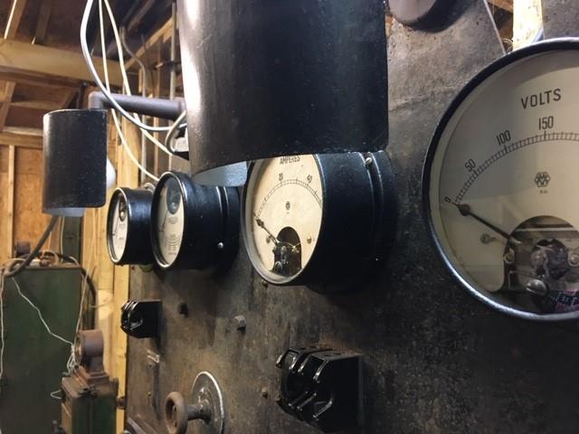
The Power House was originally constructed in 1934/35 at a time when Brown’s was not yet connected to the local electric power grid, [Fig. 23]. It was built to house an engine and Lister generator with which to provide DC electrical power to the Clubhouse, the fountains and to irrigate the courses and pump away the frequent flood waters, [Fig. 24]


Brown’s Golf Course, Sandown Conservation Management Plan March 2020 18
Fig 21 – Ice Cream Factory and store c 1938 (Jacky Macdonald Collection)
Fig 22 – Former Ice Cream Factory and store, 2019 (Author’s own)
‘PLUTO’ Power House
Fig 23 – West elevation of Power House standing in floodwater c.1934/5 (Jacky Macdonald Collection)
The Power House, like the rest of Brown’s, was requisitioned by the War Department in the early years of WW2. In 1944 it was extended with a new a new wing constructed on its north elevation. This created space to install two large Ruston engines which created a generating capacity of over 300 amps or 70 kW, [Fig. 25]. There is some debate whether the Ruston engines currently in situ were the same as those introduced in 1944. However, Searle (2017), suggests the additional capacity the engines provided was required as a backup power source for the operation of the Pipeline-under-the-Ocean project (PLUTO) fuel pumps should the local mains supply fail. The wider Brown’s / Granite Fort area contained 14 PLUTO pumps yet was located at the end of a vulnerable single overhead power line. It is probable that this vulnerability was recognised by the military and therefore plant was installed that could at least keep part of the operation working should mains power be lost.

Having undergone extensive restoration in 2016/2017 the Power House is a single-storey timber frame building with a double gabled front and small central veranda Similar to the Clubhouse its elevations are clad in elm board It has a pitched roof to the front and south sides with flat roofs to the north and west. The windows on the two gables ends and on the extension are currently boarded over and awaiting reinstatement. In many respects it resembles a fairly un-remarkable park pavilion building but for the two groups of three external coolant drums and the pipes of the exhaust system for the internal generators located on its south and west sides, [Fig 26].

Brown’s Golf Course, Sandown Conservation Management Plan March 2020 19
Fig 24 – 1930s Lister generator in Power House c.1990 (IWHER 6149_AI_8)
Fig 25 – 1940s Ruston and Hornsby generator in Power House, c.1990 (IWHER 6149_AI_5)
Asbestos shed


A large but derelict apex-roofed, corrugated asbestos-clad shed is located in Area C on the site’s boundary with the derelict Grand Hotel site, [Fig 30]. Photographic evidence suggests this building actually pre-dates the Grand Hotel and was probably constructed when the Red and Yellow Course extension was laid out in 1934, [Fig 31].

Brown’s Golf Course, Sandown Conservation Management Plan March 2020 20
Fig 26 – Western elevation of Power House showing set of coolant tanks, 2007 (Robin McConchy)
Fig 27 – East elevation of Power House, 2019 (Author’s own)
In 2017 Sandown’s ‘Men in Sheds’ have been working to restore the Power House’s internal machinery to working order after years of non-use, [Figs 28 & 29].
Fig 28 – Derelict interior of Power House, 2015 (Claire Hector)
Fig 29 –‘Men in Sheds’ working on Rushton engine, 2019 (Author’s own)
Fig 30 – Asbestos shed, 2019 (Author’s own)
Fig 31 – Aerial photo of Brown’s c.1934, showing location of asbestos shed (Jackie Macdonald Collection)
Maintenance shed
A contemporary apex roofed corrugated metal shed is located in a small maintenance yard on the western boundary of Area B. The shed houses equipment associated with the upkeep of the site.
Hard landscapes and site furniture
Footpaths and car park
Footpaths are confined to Area A where four short, winding black tarmac paths extend from a broad tarmac apron around the front of the Clubhouse. Two of these paths skirt to the east and west of the site’s two fountains respectively and meander south across the White Course to join Culver Parade. A further path extends east to link to the former Ice Cream Factory and a fourth skirts the southern edge of Brown’s gravel car park to the west of the Clubhouse.

The path network remains largely as laid out in 1933 at the time of the construction of the second Clubhouse and extension of the course. It is notable that the 1933 layout included the path from the Clubhouse to the site of the Ice Cream Factory which, was not constructed for a further 5 years, [Figs. 32 & 33].

Fencing and boundaries
The treatment of boundaries varies widely across the site from decorative wooden picket fencing around Area A to far less formal boundary definition where the course runs into woodland and reedbed in Areas C and D
The existing picket fencing in Area A appears to have replaced chestnut pale fencing which old photographs suggest was used from the 1930s until at least the 1970s, [Figs. 34 & 35]. At some point in the post-war period brick/stone posts were introduced along the boundary with Culver Parade to support the fencing. These remain extant and in fair condition. The picket fencing running along the Culver Parade boundary is vulnerable to vandalism and is regularly patch-repaired by site staff However, as the site’s principal boundary with the public highway this feature would undoubtedly benefit from a more comprehensive programme of restoration when funds become available
Brown’s Golf Course, Sandown Conservation Management Plan March 2020 21
Fig 32 – Path network circa 1934 (Jacky Macdonald Collection)
Fig 33 – Brown’s path network (www.google.com/maps Accessed 6/6/19)
Furniture
Furniture is largely confined to Area A of the site. The exceptions are the bins and flags that mark the course tees and holes, and a couple of simple timber plank benches near the Power House A collection of generic timber garden benches, tables and picnic benches are located around the Clubhouse A few more benches are located on the west side of the former Ice Cream Factory.


Several concrete planters painted white are strategically located in the car park to prevent cars colliding with the storage area fence. Also located in the car park are 5 hooped metal bike stands next to the toilet block.
Towering over the White Course are ten floodlight columns. It is understood the greens were floodlit to allow evening play from the 1950 – 1970s Whilst the existing columns appear to be more recent additions it is clear they have not been used for many years with several missing their lamps These redundant structures should be removed if no alternative use can be found for them, [Fig. 36].
Brown’s Golf Course, Sandown Conservation Management Plan March 2020 22
Fig 36 – Image showing picket fence in foreground, c.1933 (Jacky Macdonald Collection)
Fig 37 – Image showing picket fence in foreground, c.1970 (Stefan Wells)
Fig 36 – Redundant floodlight columns in Area A, 2019 (Author’s own)
Fig 37 – Signage in Area A, 2019 (Author’s own)
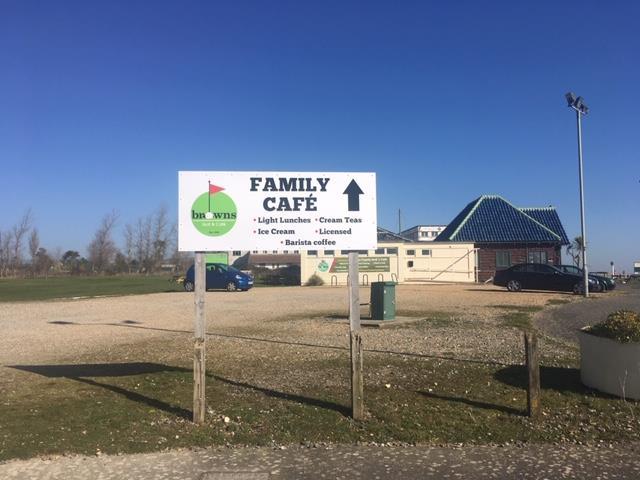
There is little signage across the site and little need for it The signage that is present is generally tired, lacks uniformity and does little to convey a coherent image for the site. A large board advertising Brown’s, Dinosaur Isle and the municipal car park is located in the south east corner of the site facing east along Culver Parade. A further board advertising the café is located at the entrance to the site car park, [Fig. 37]. Plaques advertising Brown’s Golf and Café are located on the brick fence posts either side of the paths leading from Culver Parade to the Clubhouse. Banners advertising other attractions and events are sometimes hung from the picket fence on Culver Parade.

Brown’s existing logo is strong and efforts should be made to ensure its consistent use whilst minimising / removing existing visual clutter on the site.
Fountains
Two symmetrical ornamental cascading fountains structure are located on the White Course to the front of the Clubhouse. Photographic evidence puts their construction at 1933/34, [Fig. 38]. At this time they were formed of a central one metre tall water fountain standing in a single circular pool approximately 4 metres in diameter. Sometime in the early post-war period a second concentric pool was added to each fountain. Finished in blue glazed tiles similar to those on the Clubhouse by the early-1980s these outer pools had been planted with decorative bedding displays. It is understood the fountains remained operational into the late-1980s after which they were fully given over to beddings displays, [Fig. 39]. The pumps for the fountains were lost when the toilet block in which they were housed was demolished to make way for Dinosaur Isle in the late 1990s

Soft landscapes Trees
There are a small number of trees on the site. The principal grouping is a distinctive belt of half a dozen trees between the ‘Blue’ course and the ‘Red and Yellow’ courses. They include a couple of wind-shaped oaks, hawthorns and Scots Pines, [Fig. 40] Otherwise the site contains a few Hawthorn trees in the north of the Red Course and a gloriously sprawling willow to the north of the Power House, [Fig. 41].
Brown’s Golf Course, Sandown Conservation Management Plan March 2020 23
Fig 38 – Playing in fountain, c.1938 (Jacky Macdonald Collection)
Fig 39 – Eastern fountain, 2019 (Author’s own)
It is not evident the site has benefitted much in the way of positive tree management in recent years. To both replenish and ensure against further loss of arboriculture features it is recommended that a programme of restocking is included in a comprehensive management and maintenance plan for the site
Grassland
The vast majority of the site comprises closely managed grassland of varying lengths depending on its designated use – longer for the rough, shorter for the fairway and closely cropped for the greens. Cotton’s original design incorporated many sand bunkers in the roughs and fairways. These were extant until the late 20th century but have now grassed over and are visible only as grass mounds and hollows which nevertheless continue to serve as hazards across each of the courses.
Archaeology
Parts of the site have potential to yield evidence about its historic use by the military from Tudor times to the early 20th century. The local Historic Environment Report which is maintained by the Isle of Wight County Archaeology and Historic Environment Service records evidence of five monuments on the site - Cotton’s 1930s Golf Course, the PLUTO Power House and 3 military boundary stones associated with the Granite Fort.6

Views and vistas
Despite its low elevation the site offers visitors a range of fine views and vistas These include:
• north towards Brading Downs, [Fig. 42];
• east from Area C towards Bembridge Fort located on Culver Down;
• west from Area C towards Sandown and the prominent church, St James the Evangelist;
• south from Area B towards the Clubhouse and Sandown Bay beyond.

Brown’s Golf Course, Sandown Conservation Management Plan March 2020 24
Fig 40 – Central belt of trees, 2019 (Author’s own) Fig 41 – Hawthorns to north of 8th hole, 2019 (Author’s own)
6 IWC Historic Environment Record, (2019)
Ecology
The closely managed amenity grassland that characterises the majority of the site doesn’t suggest an area of great ecological interest. However, sitting at the centre of a network of different habitats including woodland, wetland, bracken lagoon, sand dunes and tidal beach, Brown’s has a surprisingly rich natural heritage.
On 12 May 2018 the site was the venue for the Isle of Wight Natural History and Archaeological Society’s (IWNHAS) annual Bio-blitz event. This event encourages members of the public to work alongside ecologists to record as many species as possible within a given area in a 24 hour period. In particular the PLUTO Power House yielded a huge concentration of the larva of the Bagworm moth (Luffia ferchaultella). This species has been seen in a number of places on the Island but only in low quantities previously.

The grassy edges of the car park turned up some specialist plants of dry sandy grassland including bird’s foot clover, knotted clover and subterranean clover. The ornithologists reached a total of 51 species including swifts, oystercatcher and whimbrel spotted overhead In addition, the Isle of Wight Council’s Local Records Centre reports a number of ‘red list’ and ‘local priority species’ of flora recorded on the site 7 These include:
• Bottle Sedge (Carex rostrate);
• Early Meadow-grass (Poa infirma)
• Ray’s Knotgrass (Polygonum oxyspermum)
• Borrer's Saltmarsh-grass (Puccinellia fasciculata)
• Lesser Spearwort (Ranunculus flammula)
• Large Wainscot (Rhizedra lutosa)
7 IWC Local Records Centre, (2019)
Brown’s Golf Course, Sandown Conservation Management Plan March 2020 25
Fig. 42 – View towards Brading Down (http://www.geography.org.uk Accessed 12/5/19)
2.4 Management arrangements Day to day responsibilities
The Clubhouse, putting courses and pitch and putt courses are managed on behalf of Brown’s (IOW) Ltd by the on-site team - John Deacon, Cheryl Brazer and Clare Oatley. The site currently supports four core staff in addition to a number of seasonal employees recruited to manage the greens and cook / serve in the Clubhouse café. As might be expected the upkeep of the site is labour intensive during the playing season with each of the 72 greens mown twice a week and the fairways once a week.

The former Ice Cream Factory is sub-let from Brown’s (IOW) Ltd by Arc Consulting.
The ‘PLUTO’ Power House is managed on an informal basis by Sandown ‘Men in Sheds’ volunteers on behalf of Brown’s (IOW) Ltd
With no overall plan for the management and maintenance of buildings on the site patch repairs are generally undertaken by the tenants on a needs basis. The exception is the PLUTO Power House which, has benefitted from a comprehensive programme of restoration in recent years and is currently maintained by the Men in Sheds initiative.
Brown’s Golf Course, Sandown Conservation Management Plan March 2020 26
Fig 43 – Polite notice to help maintain the condition of Brown’s courses (Author’s own)
2.5 Historic development
The historic development of Brown’s has been researched by Isle of Wight Gardens Trust as part of its inventory of local parks and gardens The following section draws on this account supplemented by additional archival research and information gleaned from interviews with the site’s current tenants and relatives of Mr Al Kennedy.
Phase 1: Pre-history – Tudor period
For much of its history the site consisted of mud flats and floodplain lying on the eastern bank of a tidal inlet on Sandown Bay. At high tide this inlet allowed the sea to flow through the location of the former Canoe Lake and across Sandown Levels to join another branch of sea flowing inland from Brading Harbour. This pincer movement by the sea at high tide and during flood events cut off the Brown’s site, along with the rest of Yaverland and Bembridge, from the rest of the Island to form Bembridge Isle.8
Whilst nearby Brading sustained a Roman villa for nearly four centuries from 44BC, Sandown Bay was only sparsely populated by the time of the Domesday Book in 1086. This recorded a small settlement of 8 households at ‘Sande’ (Sandown) with just one at nearby Lake. Slightly larger settlements numbering twenty and seventeen households were recorded at Yaverland and Shanklin respectively 9
Phase 2: Tudor Forts – Palmerston Forts
The military significance of Sandown Bay as a defensive position was seized upon by Henry VIII following an increase in tensions with France and the Holy Roman Empire following his break with Rome in 1532. From 1539 he ordered a programme of coastal fortifications - or devices - to be built including a new castle at Sandown close to the site now occupied by Brown’s The Tudor castle lasted little more than a century, succumbing to coastal erosion and the remains of the structure were demolished in 1631 with its stone used to construct a new fortification, Sandham Fort in 1632. 10
The new fort was located further inland on what would have been the west bank of the tidal inlet A 1725 plan of the Fort shows no trace of the sea inlet but describes much of the land to the immediate north and east as marshland, [Map 4]. The area now occupied by Brown’s includes some of this marshland, criss-crossed by land drains, as well as several ploughed fields enclosed by hedgerows. The 1725 plan suggests little human settlement in the area with only a clutch of dwellings to the north-west of the Fort at Sandham Green
8 Isle of Wight County Archaeology and Historic Environment Service (2008) pp.1
9 https://opendomesday.org/place/SZ6084/sandown/ Accessed 4/12/19
10 Isle of Wight County Archaeology and Historic Environment Service (2010) pp. 8
Brown’s Golf Course, Sandown Conservation Management Plan March 2020 27
Later illustrations including Sandham Fort by John Nixon c.1788, The Grand Review at Sandham Bay by Richard Livesay, 1798 and Sandham Fort by Charles Tomkins, 1809 appear to show the area to the east of the Fort to be heavily wooded, [Fig. 44 and 45] These impressions may well be a matter of artistic licence as a 1790s Ordnance Survey Drawing again shows the area to comprise small irregular fields, [Map 5].11

11 Basford, V (2013) pp.429

Brown’s Golf Course, Sandown Conservation Management Plan March 2020 28
Map 4 - Plan of Sandam Fort in the Isle of Wight dated 1725 with the approximate location of Brown’s marked in red, (British Library)
Map 5 - Strip enclosures at Yaverland 1790s Ordnance Survey Drawings, (British Library)


Brown’s Golf Course, Sandown Conservation Management Plan March 2020 29
Fig 44 - The Grand Review at Sandham Bay, Richard Livesay, 1798. (Private Collection)
Fig. 45 - Sandham Fort by Charles Tomkins, 1809 (Private Collection)
Sandham Fort was also prone to coastal erosion and in the 19th century was demolished to be replaced by the Granite Fort. The new fort was constructed in the 1860s on land to the east of the Brown’s site as part of Lord Palmerston’s improvements to England’s coastal defences in the face of the perceived threat of invasion by Napoleon III’s Navy, [Fig. 46].

Phase 3: 1860 - 1930
The 1862 edition of the Ordnance Survey 6-inch map shows the site as undeveloped land consisting of two large field plots bordered to the north and west by marshland, [Map 6] A new road passes to the south linking the much-expanded settlement of Sandown to the west with Yaverland to the east. To the immediate east we know work had started on Palmerston’s Granite Fort in 1861 but given the military sensitivities of the time it does not feature on the 1862 map

Brown’s Golf Course, Sandown Conservation Management Plan March 2020 30
Fig 46 - Granite Fort under construction, London Illustrated News, 1863 (Private Collection)
Map 6 – 1862 OS 6-inch map showing approximate location of Brown’s in red (IWCRO)
The 1898 edition of the Ordnance Survey 6-inch map shows little change from 1862 with the exception of a small plantation emerging on the western boundary of what is now Brown’s and a line of War Department boundary stones crossing the site west to east, [Map 7]

The collection of prolific local photographer James Dore (1854-1925) contains numerous images of troops parading and camping on the site over the late 19th and early 20th centuries. These include soldiers of the IoW Militia, IoW Fusiliers and Hampshire Voluntary Artillery A glass plate of soldiers running an 18-tonne gun from Granite Fort along the track road towards Sandown also shows a very pastoral Brown’s site in the background site with hay stoops and two large ricks, [Fig. 47]

Brown’s Golf Course, Sandown Conservation Management Plan March 2020 31
Map 7 – 1898 OS 6-inch map showing approximate location of Brown’s in red (IWCRO)
Fig. 47 - 18-tonne gun on Sandown seafront near Granite Fort, c. 1900 James Dore (IWCMS: 2012.88)
In the early years of the 20th century the military importance of Granite Fort was wound down and during WW1 it was used only as a practice battery to help train conscripted soldiers. In 1929 the War Department put the Granite Fort and adjacent land up for auction as a whole or in three lots, [Figs. 48]. On 3 February 1930 George William Ball, a builder of Cowes acquired the whole estate.12


Brown’s Golf Course, Sandown Conservation Management Plan March 2020 32
Figs 45 - Sales details of Granite Fort, 1929 (IWC)
12 Isle of Wight Council: Record of conveyance War Dept to Ball (3 February 1930)
Phase 4: 1930 – 1935 Establishment of Brown’s Golf Course
George Ball immediately disposed of Lots 1 and 2 of his acquisition retaining only Lot 3, the Granite Fort itself. Lot 1 was acquired by the owners of the adjacent Canoe Lake. Lot 2 was acquired by Mr Alexander Kennedy (1875 – 1942). Kennedy was the owner of a successful chain of south London sausage and pie shops and a regular visitor to Sandown, owning a property in the town Described in the sales particulars as seven acres of pasture here he planned to develop a miniature golf course that would capitalise on Sandown’s increasing popularity as a coastal resort 13
Kennedy persuaded his friend, South London neighbour and leading professional golfer Henry Cotton to design the course. Cotton’s designs comprised a timber Clubhouse pavilion in the centre of the plot with three six hole putting greens - Village Green, Gretna Green and Turn-em Green – to the south and two nine hole pitch and putt courses - Chip-Putting Course and Bantam Golf
to the north. The Clubhouse was constructed by local building firm W.J Simmonds & Sons of Yarbridge with groundworks completed by Clark & Co of Victoria Street, Westminster, London.14
The course was named Brown’s on account of this being Kennedy’s nickname, [Fig. 46]. It was perhaps only fitting that Cotton took centre stage in its official opening by playing the first round of golf on a rainy Easter Saturday, 26 March 1932

A member of staff was employed to show players how to ‘pitch’ for those who had only ever played on putting greens and the course was generally well patronised However, the small putting greens were less popular and the three were combined into one eighteen hole course with oversized holes for ease of play later in 1932.15
14
15 Ibid
Brown’s Golf Course, Sandown Conservation Management Plan March 2020 33
–
Fig 49 – Advert for Brown’s, c. 1932 (Sandown Chronicle)
13 Isle of Wight Council: Record of conveyance Ball to Kennedy (3 February 1930)
Bambrough, D. (2009) pp1
Building on the success of Brown’s in June 1932 Kennedy acquired a further ten acres of adjoining land to the north from Mr Herbert Fleming on which to extend the course, [Fig 50] Again he called on the services of Henry Cotton to help with its design. Over the next year a new more challenging, undulating fourteen hole course took shape with a greater number of hazards such as sand bunkers and Cotton’s feature 8th hole. This comprised a raised teeing-off hut and putting green in the shape of the Isle of Wight complete with Needles, a lighthouse and water hazard representing the surrounding seas, [Fig 51] At the same time the original Clubhouse was replaced with a larger version with ‘Golf for Everybody’ emblazoned on its roof, [Fig. 52]. Further embellishments followed soon after including twin cascading fountains built in front of the new clubhouse and a new toilet block and car park constructed on the western edge of the putting green.


Brown’s Golf Course, Sandown Conservation Management Plan March 2020 34
Fig 50 – Kennedy’s 1932 10 acre extension to Brown’s shown in pink (IWC)
Fig 51 – Cotton’s Isle of Wight 8th green, c 1933 (Jacky Macdonald Collection)
Fig 52 –Clubhouse v.2, 1934 (Jacky Macdonald Collection)
The course extension was officially opened on 11 July 1933 with a ‘big money’ exhibition match between Henry Cotton and Joe Kirkwood, an internationally renowned professional and exhibition shot golfer based in Miami, USA, [Figs 53 & 54] Kirkwood defeated Cotton over two rounds and by accounts, the spectacle was enjoyed by several hundred spectators.


In November 1933 Kennedy purchased a further 4 acres of land to the north of Canoe Lake –today’s Area D, [Fig 55]. He used this to extend the pitch and putt course from fourteen to eighteen holes and to extend one of the shorter courses from nine to eighteen holes Henry Cotton, who by this time was British open champion, was booked to play another 36-hole exhibition match on July 3rd1934. His opponent on this occasion was Mr. F. G. Shilling, professional at the Sandown and Shanklin Golf Club. Cotton was simply too good for his local opponent, his score for the 36 holes was 105, three under par, Shilling’s was 111 16

Brown’s Golf Course, Sandown Conservation Management Plan March 2020 35
Fig 53 – Joe Kirkwood teeing off on 8th hole, 11/7/33 (Jacky Macdonald Collection)
Fig 54 – Cotton, Kennedy and Kirkwood on steps of Clubhouse 2, 11/7/33 (Jacky Macdonald Collection)
Fig 55 – 1933’s four acre extension to Brown’s shaded pink (IWC)
16 Bambrough, D. (2009) pp2
Phase 5: 1935 – 1939 Improvement and expansion
From 1935 – 1938 Kennedy continued to add to his land holdings in the area In November 1935 he acquired approximately twenty-seven acres of mostly wet pasture to the north of the golf course from Mr Ernest Smith for £1,250. This he leased to local stockmen for grazing with cattle. Importantly however, the acquisition gave him access to the River Yar at Morton on the banks of which he built a pump house to abstract water from the river for the irrigation of Brown’s
Electricity had not yet reached the site so in 1935 Kennedy commissioned the construction of a building to house a generator to provide the site with power. The Power House was constructed in the north west corner of the course – Area D - to provide the site with its own DC power supply, [Figs. 56 & 57]

Business boomed and by 1936 the second Clubhouse could no longer meet demand and was replaced by a much larger third iteration with a distinctive blue-glazed tiled roof. This new Clubhouse included a kitchen and serving hatch on its north side and club hire on the south, [Fig 58]. The following year a large shelter was erected behind the Clubhouse so that players could shelter from inclement weather and to provide covered seating space for patrons of the café, [Fig. 59].
Brown’s Golf Course, Sandown Conservation Management Plan March 2020 36
Fig 56 – Power House in flood water, c.1935 (Jacky Macdonald Collection)
Fig 57 – Rear of Power House c.1935 (Jacky Macdonald Collection)
Fig 58 – Serving hatch at rear of Clubhouse 3, c 1936 (Jacky Macdonald Collection)
Fig 59 – Shelter on rear of Clubhouse 3 c. 1937 (Jacky Macdonald Collection)
A further statement of Mr Kennedy’s intent to make Brown’s a first class attraction came with the construction of the site’s own Ice Cream Factory to provide ices for the Clubhouse café, [Figs 60 & 61]


In February 1938 Al Kennedy acquired a further 8 acres of land to the rear of the Granite Fort from Mr Ball’s Parklands Estate for £1,200 17 This was incorporated as a further extension to the existing course, [Fig. 62]. By the end of 1938 Brown’s was a modern, thriving leisure amenity which, alongside the Canoe Lake, Sandham Gardens and sandy beach, contributed to a critical mass of attractions for locals and visitors alike in the coastal resort town of Sandown.
17 Isle of Wight Council: Record of conveyance Parklands Company to Kennedy (February 1938)

Brown’s Golf Course, Sandown Conservation Management Plan March 2020 37
Fig 60 - Brown’s Ice Cream Factory 1938 (Jacky Macdonald)
Fig 61 – Dick Kennedy working in Brown’s Ice Cream Factory 1938 (Jacky Macdonald)
Fig. 62 – 1938 eight acre extension to Brown’s, shaded in pink (IWC)
Phase 6: 1939 – 1945 WWII and the D-Day effort
The outbreak of hostilities in September 1939 was the start of a remarkable new chapter in the story of Brown’s By 1942 the site had been requisitioned by the War Department and the length of Culver Road was put out of bounds to the public.18 Using the cover of the existing golf course buildings the site was secretly used to accommodate apparatus required for the PLUTO (Pipeline Under The Ocean) fuel line designed to supply fuel to the D Day landings in France. The Power House was used as a back-up power supply for the pumps which pumped the fuel to the Normandy beaches. One of these pumps was located under the Clubhouse Shelter and another in the Ice Cream Factory with others in the nearby Granite Fort.19 In total 16 pumps are believed to have been located between Browns and the Granite Fort.20
Alf Keiling, Brown’s chief green keeper from inception of the course, was retained by the military as caretaker for the site, [Fig. 63]. Paradoxically perhaps he was forbidden to cut the grass and was required to make sure nobody walked over the grounds to ensure no paths were formed that would indicate to German spy planes that the site was in active use.21

18 Bambrough, D. (2009) pp3
19 Brett, E. (2015) pp2
20 https://historicengland.org.uk/listing/the-list/list-entry/1391723. Accessed 24 September 2019
21 Bambrough, D. (2009) pp3
Brown’s Golf Course, Sandown Conservation Management Plan March 2020 38
Fig 63 – Alf Keiling, Brown’s Chief Green Keeper 1932 – 1960, on his tractor c.1936 (Jacky Macdonald Collection)
On August 16th 1942 Alexander Kennedy, the founder of Brown’s, died at Beckenham Hospital, Kent and responsibility for the golf course passed to his son Mr AR Kennedy.
Phase 7: 1946 – late 1960s, the boom years
A lack of maintenance of greens, fairways and bunkers during the war years meant that considerable repair work was required before the course could be reopened to the public Whilst the restoration works were underway the opportunity arose to purchase the adjacent Sandown Canoe Lake. It was duly acquired by AR Kennedy for £10,000 in 1946.22 The Canoe Lake had suffered badly in the war, taking some direct hits from German bombers emptying their loads when returning to mainland Europe from sorties to bomb the Solent ports. Similar to Brown’s it was therefore in need of considerable restoration before it could be reopened to the public.23
The restored and repaired Golf Course and Canoe Lake eventually reopened in the summer of 1947 with Al Kennedy’s daughters Lorna and Edith placed in charge of managing Brown’s and the Canoe Lake respectively Work was undertaken to strengthen physical links between the two attractions with the construction of a wide path flanked by gardens, seating and recreation space, [Figs 64].
The two decades following WW2 were something of an Indian Summer for British seaside resorts. Rationing ended, austerity ceased and business boomed The holiday abroad was still the preserve of the few and package tours were non-existent. The Island and Sandown rode this wave. A new zoo attraction was established within the Granite Fort to further extend the options for holidaymakers This was all good news for Brown’s and the Canoe Lake which, enjoyed a symbiotic relationship - Brown’s Ice Cream Factory supplied the new Canoe Lake café with ices and the new Canoe Lake bakery supplied the Clubhouse with its renowned cream doughnuts, [Fig. 65].
22 Isle of Wight Council: Record of conveyance Sandown Canoe Lake Company Ltd to Brown’s Golf Course Ltd (1 March 1936)
23 Sandown Canoe Lake, Isle of Wight Gardens Trust, (2012) pp.4

Brown’s Golf Course, Sandown Conservation Management Plan March 2020 39
Fig 64 – View towards Brown’s from Canoe Lake, c. 1970s (Rob Chiverton Collection)
Phase 8: Late 1960s – 1979 End of the Kennedy era
Sandown was not however immune to the many challenges that the UK’s seaside resorts faced towards the end of the 1960s. Rising wages, increased leisure time and the rapid expansion of affordable foreign package holidays meant that holidaymakers no longer had to tolerate what were often grim seaside guesthouses with limited hot water, crowded roads, stuffy trains, uncertain weather and cold seas.
For Brown’s the late 1960s and into the 1970s were a period of gentle decline. Popular but costly to maintain facilities were no longer deemed financially viable. The Ice Cream Factory was closed, the cascading fountains were filled with ornamental bedding and many of the sand bunkers across the course were gradually reclaimed by grass.
In 1979 the Kennedy family sold Brown’s and the Canoe Lake to Mr and Mrs Snelling of Bembridge.24

Phase 9: 1980 – 1990 Change and churn
The Snellings arrived with new ideas to increase the appeal and profitability of Brown’s. In 1980 they secured planning permission to convert the former Ice Cream Factory to for use as a lounge, model railway, gift shop and toilets. The Snellings continued to operate the golf course much in the same way as the Kennedys. They did not eventually pursue their plans for the former Ice Cream Factory and in 1986 submitted a revised planning application to create a lounge and amusement arcade within the building. These revised plans did not go ahead either and in 1987 ownership of Brown’s and the Canoe Lake passed to a Southampton based operator, Leading Leisure.
Brown’s Golf Course, Sandown Conservation Management Plan March 2020 40
Fig 65 – Canoe Lake c. 1960 (Jackie Macdonald Collection)
24 Bambrough, D. (2009) pp3
Leading Leisure had ambitious plans for the entire estate – Brown’s, the Canoe Lake and the agricultural land to the north that Al Kennedy had acquired in the 1930s In 1989 they submitted a planning application to South Wight Borough Council (SWBC) for:

“A water park to include the following: Indoor and outdoor leisure rides and amusements, showboat lake and bingo hall, supermarket, leisure centre, car parking, Sandham Fort holiday and permanent accommodation and the closure of Culver Parade to vehicular traffic.”25
These proposals were not supported and by the Autumn of 1990 Leading Leisure had called in the receivers and ownership of the whole estate passed to SWBC.26
Phase 10: 1990 – 2011 Municipalisation and closure
Brown’s continued to be operated as a pitch and putt course under the stewardship of SWBC until 1995 when the borough council was subsumed into the new Isle of Wight Council (IWC) unitary authority. By this time the Canoe Lake had fallen out of use and was sold off to a private developer save for a small strip which, was retained by the local authority.
The IWC continued to run Brown’s and in the late 1990s tabled ambitious plans for a new museum to house its geology and palaeontology collections to be constructed on land between the golf course and Canoe Lake With funding secured from the National Lottery’s Millennium Commission Dinosaur Isle was opened on 10th August 2001, [Fig. 66] The physical impact on Brown’s was four-fold: 1) demolition of its existing toilet block and car park; 2) construction of a new, utilitarian toilet block on the west side of the Clubhouse; 3) the loss of a small area of the Blue Course to a new car park; and 4) removal of the site’s maintenance sheds to make way for a new municipal car park
25 South Wight Borough Council planning records (June 1989)
26 South Wight Borough Council (November 1990)
Brown’s Golf Course, Sandown Conservation Management Plan March 2020 41
Fig 66 - Dinosaur Isle Museum (Wikipedia)
In 2006 the Power House was listed at Grade II by English Heritage (now Historic England), on the basis of the:
“exceptionally intact WWII machinery housed within the building as well as the way a humble shell is cleverly employed to make its function discrete. It is a rare survival of nationally significant wartime endeavour and is one of the best preserved of the last physical remains of Operation PLUTO.”27
The IWC continued to maintain and operate Brown’s as a going concern until 2010 when central government’s programme of austerity began to bite and the IWC called time on the golf course. Unfortunately, the reduction of management and maintenance of the site in the preceding years proved inauspicious for the Power House which, became a target for vandals and whose attentions left parts of the building exposed to the elements and increasingly vulnerable to further decay, [Fig. 67]
Phase 11: 2011 – Present Day Rescue and resurrection
During 2010-11 a question mark hung over the future of Brown’s. Not for the first time speculation about the site’s development potential circulated within the local community Perhaps in a bid to safeguard the site from unsympathetic development in April 2011 Brown’s (IOW) Ltd entered into a 25 year lease for the site with the IWC.
27 https://historicengland.org.uk/listing/the-list/list-entry/1391723. Accessed 24 September 2019

Brown’s Golf Course, Sandown Conservation Management Plan March 2020 42
Fig 67 – Derelict PLUTO Power House c.2011 (Tim Wander)
Since 2014, John Deacon, Cheryl Blazer and Clare Oatley have been working with Brown’s (IOW) Ltd to restore the fortunes of the site Faced with knee high grass on arrival the team quickly restored greens and fairways and remarkably were able to open Brown’s Family Golf for the 2014 season.
Since 2014 the site has flourished and has established itself as a destination for all and not just those people wishing to play golf With its large, natural lit covered space and fine views the Clubhouse Café has become a popular lunch, coffee and cake destination for families and during the summer months often opens in the evenings to accommodate fitness classes, art workshops, band practices and special events, [Figs. 68]. This includes the popular ‘Campfire Sessions’ which were established by Clare and Spike Oatley to provide a platform for local music talent and were adopted by Sandown’s Coastal Community Team for the purposes of public consultation, [Fig. 69]

Brown’s Golf Course, Sandown Conservation Management Plan March 2020 43
Figs 68 – Art workshops @ Brown’s 2018 (Claire Hector)
69 – Campfire Session at Brown’s, 2018 (Claire Oatley)
The former Ice Cream Factory and Store were sub-let to three dynamic local enterprises: Eccleston George, a collective of local artists; Arc Consulting, a broad-based environmental consultancy and Artecology, an innovative, environmental impact company The arrival of these new tenants with a commitment to support the resurgence of the site has seen use of the facility expand and diversify to include:
• Campfire Sessions, Discovery Bays and Hullaballoo
• A manufacturing base for Artecology’s ‘Vertipools’ and ‘Bio-totems’ ;
• A hub for exploration of local natural heritage by schools and universities.

Despite much positive activity across the site by 2015 the condition of the Power House was parlous. Repeated acts of vandalism and the subsequent ingress of rainwater posed a real threat to its survival. Fortunately, the triumvirate of Arc, Ecclestone George and Artecology, supported by the Isle of Wight Area of Outstanding Natural Beauty partnership secured a Coastal Revival Fund award of £50,000 towards the repair and restoration of its built fabric.28 During restoration works a group of retired local men came together as part of IW Age UK’s Men in Sheds initiative to make good the internal spaces and restore its plant, [Figs. 71 & 72]. The group continue to meet on-site each week to work on its restoration and open the building to the public for events including Hullaballoo and Heritage Open Days
28 On the Wight 12/12/2015 (Accessed 12/12/19)

Brown’s Golf Course, Sandown Conservation Management Plan March 2020 44
Fig 70 – A stack of Vertipools waiting for export, 2020 (Authors own)
Figs 71 & 72 - Men in Sheds restoring internal engines of PLUTO Power House (Author’s Own)
2.6 Wider context
This section considers the social and economic conditions that enabled the development of Brown’s by looking in brief at the rise of mass tourism and the English seaside resort, Sandown’s development as within this phenomenon and the part played by pitch and putt.
Mass tourism and the rise of British seaside resort
From the 1730s the healthy benefits of the seaside gained wide popularity amongst the upper and middle classes By the 19th century seaside resorts were amongst the fastest growing towns in a time of rapid industrialisation. Early ‘genteel’ seaside resorts such as Brighton, Scarborough, Weymouth, Worthing, Hastings, Great Yarmouth and Margate were joined in the market by new or expanded coastal towns including Blackpool, Bournemouth, Skegness, Morecambe, Weston-Super-Mare, Minehead, Southsea and many more. From the 1870s the growth of these towns was accelerated by a seemingly interminable wave of new visitors. Rising wages, increased leisure time and improving transport infrastructure meant that for the first time a trip to the coast was within the reach of England’s urban workingclass. Those who could afford it wasted little time in taking full advantage of the opportunity.29
Initially visits were confined to train borne day trips but the number of staying visitors quickly multiplied. Hassan (2013) reveals that by 1911, 55% of English people were visiting the seaside on day excursions and 20% were talking holidays requiring accommodation. The holiday industry involved about 1.25% of the population and accounted for 1.5% of consumer expenditure. By 1934 the Survey of London Life and Labour estimated that half the workforce in London took holidays away from home Never before had so many people the chance for a holiday beside the sea.
Walton (1981) argues that five conditions had to be met for the British Seaside to attract working class residential tourists and so ensure the development of the seaside resort These were:
• Railways – providing cheap and effective transport to the coast;
• Income - people had to have sufficient disposable income to afford a holiday in times when holidays were not paid;
• Free time - visitors would need to be able to take several consecutive days holiday in the summer;
• Supply - the resorts had to have sufficient things for visitors to do beyond the sea and beach;
• Appeal - resorts needed to be attractive to persuade people to choose to spend their hard earned money in one resort over another
To this list we might add that land ownership, local government, entrepreneurial activity, topography and transport all also had their effect on resort growth
29 Rosslee and Chapman, (2016) pp.3
Brown’s Golf Course, Sandown Conservation Management Plan March 2020 45
Sandown – a ‘bucket and spade’ coastal resort

From Tudor times to the late 18th century Sandown was a military outpost and small fishing village One of the first substantial non-military buildings to be constructed in the village was 'Villakin' in 1788 which was a holiday home leased by the radical politician and one-time Mayor of London John Wilkes. Perhaps due to its relative remoteness the resort development of Sandown was slow compared to other coastal resorts on the south coast Nevertheless, by the middle of the 19th century regular coaches from Ryde and Brading were bringing guests to the fledgling town which still boasted only one substantial hotel By 1851 the pace of development had quickened with the local directory promoting the town as a “pleasant bathing place”, a “charming locality for marine villas and sea bathing”. 30
The arrival of the railway in 1864 had a significant impact on Sandown’s fortunes, contributing to the doubling of the town’s population over the next decade. The visit in summer 1874 of Crown Prince Frederick and Princess Victoria of Germany helped strengthen Sandown’s claim as a fashionable English resort, an assertion given further credence with the opening of Sandown Pier in 1878 and the seafront esplanade in the 1880s. Both developments added to the resort’s appeal amongst the fashionable classes in search of a mild climate, safe bathing and clean air, [Figs. 73 & 74]. Sandown's destiny in the 20th century however was to be a bucket-and-spade favourite for all classes, [Fig 75]31


Brown’s Golf Course, Sandown Conservation Management Plan March 2020 46
Fig 73 - Sandown beach, c. 1900 (James Dore Collection - IWCRO)
Fig 74 - Sandown Hotel, c. 1900 (James Dore Collection - IWCRO)
Fig. 75 – 1970s postcard from Sandown, (Author’s own)
30 Sandown Conservation Area, Isle of Wight Council (2011) pp.6 31 ibid
Given its greater distance from London it was not until the early years of the 20th century that Sandown started to attract the consistently high volumes of working-class visitors that coastal towns of Kent and Sussex had been enjoying since the late 19th century. The town was given a boost in 1921 with the introduction of the Health and Pleasure Resorts Act. For the first time this allowed local authorities to fund the promotion of their resorts and raise funds for this activity through ventures such as the hire of deck chairs, beach tents and charging for visitor attractions
By the early 1930s Sandown had accrued many of attractions typical of English coastal resorts. The pier was extended in 1895 to include a 1,000 seat theatre and ballroom. The town also boasted two cinemas, a lido – the Blue Lagoon - a bandstand, pleasure gardens, crazy golf, the Canoe Lake and Brown’s pitch and putt, [Figs 76 & 77]. Sandown was thriving!


Pitch and putt
The world’s first pitch and putt course – which remains in use to this day - was opened a short distance from Sandown in the resort town of Southsea in Portsmouth in April 1914. This innovative new attraction quickly caught on with other coastal resort towns competing to win a slice of the increasing holidaymaker spend During the 1920s and 1930s courses popped up throughout England, usually in coastal resorts and primarily for the entertainment of holidaymakers
Brown’s Golf Course, Sandown Conservation Management Plan March 2020 47
Fig 76 – Cover of 1950s brochure promoting Sandown (IWCRO)
Fig 77 – Notice advertising exhibition match at Brown’s, 1933 (IW Chronicle)
The appeal of pitch and putt both to town fathers and entrepreneurs was that courses could be built relatively cheaply and did not require large areas of land. The few hectares required meant that a par 3 nine-hole course could readily be laid out on a relatively small area of grassland on the town edge yet within reach of a large number of people.
Gaining visibility in an increasingly crowded tourist market during the inter-war years led to business owners drawing on a range of innovative marketing strategies to get ahead. In the case of pitch and putt it seems that employing the services of a well-known professional golfer to design your course was one such approach. The owners of the Beachlands Course on Hayling Island recruited Jack Smith, sometime playing partner of the six times Championship winner Harry Vardon, to design their course. Whilst on the Isle of Wight Mr Kennedy went one better perhaps by persuading Henry Cotton to not only design the Brown’s course but also play the opening round, [Fig. 78]!

Brown’s Golf Course, Sandown Conservation Management Plan March 2020 48
Fig 78 – Henry Cotton (right) with Joe Kirkwood at Brown’s, 1933 (Jacky Macdonald Collection)
3 STATEMENT OF SIGNIFICANCE
3.1
Introduction
This Statement of Significance attempts to assess why the site is worthy of conservation. The Athens Charter of 1931 was the first international agreement that sought to codify the philosophy of conservation. Since the 1960s the process of codification has been steadily developed at a national and international level. In England publications by Historic England and the National Lottery Heritage Fund set out the current thinking on what is significant and how it is to be described. They identify four broad value categories:
• Evidential - what evidence a place can tell us about past human activity;
• Historical - the ways in a place can link people, events and aspects of life;
• Aesthetic - a source of sensory or intellectual stimulation;
• Communal – what a place means for individuals or groups of people.
Within these value categories there will be different levels of importance. These can be expressed by terms indicating the ranking of significance values. For example:
• Descriptive - Exceptional; High; Medium; Low; None; Negative;
• Geographical range - International; National; Regional; Local;
• Designation - Grade I or II*, Grade II; Conservation Area or local designation
An overall Statement of Significance for Brown’s is provided in the following section and is supported by more detailed analysis of the following themes:
• Landscape;
• Built heritage;
• Archaeology;
• Historic associations;
• Local community; and
• Nature conservation.
3.2 Overall statement of significance
Brown’s Family Golf is a fine and increasingly rare surviving example of a 1930s pitch and putt golf course. It is remarkable for having a record in use of more than 80 years, broken only by WW2 when the site played a clandestine role in the Pipeline Under the Ocean (PLUTO) effort. It is also significant as the oldest course still being played that was laid out to the designs of the UK’s leading golfer of his generation, Sir Henry Cotton.
The fortunes of Brown’s have ebbed and flowed since Alexander Kennedy, a south London butcher and enterprising businessman, acquired 5 acres of former War Department land in 1930 to lay out the course. In terms of popularity it probably reached its zenith in the 1950s when the attraction extended across almost 20 hectares and included the adjacent Canoe Lake and bakery which, produced much sought-after cream doughnuts. Today it occupies 7.5 acres, on broadly the same footprint as it did by the mid-1930s and retains many features of the introduced at this time. These include the distinctive timber and glazed-tile Clubhouse, two cascading fountains and Cotton’s gently undulating course with its distinctive Isle of Wight shaped 8th green.
Brown’s Golf Course, Sandown Conservation Management Plan March 2020 49
Brown’s history is very visible as layers in its landscape and built features. As part of the 1930s expansion a Power House and Ice Cream Factory were constructed on site to meet Brown’s increasing power and catering needs. These structures provide a strong record of the site’s evolution. They also hint at the key role the site played in Operation PLUTO from 1942 – 1945 when it was requisitioned by the War Office and its buildings used as cover to house the machinery required to pump petrol to the Normandy beaches to support D-Day. Whilst the Power House is alone in being formally designated for its historic and architectural interest, all buildings on the site together with the adjacent Palmerston Granite Fort (now the IW Zoo) and derelict 1930s Grand Hotel have strong group value for their association with Operation PLUTO.
Brown’s flowing landscape has many aesthetic and scenic qualities, creating a range of stimulating vistas across, in and out of the site. Its closely manicured fairways and greens juxtapose vividly with the blue sweep of Sandown Bay to the south and marshy floodplain to the north which, rise to spectacular chalk downs which provide a vibrant backdrop to the site. Its wind sculpted pine trees, open spaces, amenities and ambience punctuated by the occasional roar of a lion from the neighbouring zoo all contribute to Brown’s special qualities.
The development of Brown’s has been influenced by a number of locally and nationally significant individuals. Not least of which are the various members of the Kennedy family who owned the site and who had a significant role in Sandown’s development as a popular and modern 20th century seaside resort. The work of three times British Open Champion Sir Henry Cotton is evident within the site. Moreover, his game at the course in 1933 against Joe Kirkwood, an internationally renowned golf professional and exhibition shot specialist, did much to raise the profile of Brown’s and the resort town more generally.
Today Brown’s is highly valued by the local community as an historic designed landscape, publicly owned green space and leisure amenity. At various times over the past 80 years the local community has galvanised to protect the site and defend their right to access and enjoy it. In 2011 this culminated in a member of the local community – Brown’s (IOW) Ltdassuming control of Brown’s, securing its continued operation for golf, enabling four complementary local businesses to develop on the site and establishing it as the venue for a lively programme of public arts, culture and science. Perhaps underlining the strong community interest in the site is the ‘Men in Sheds’, a group of retired engineers who on a regular weekly basis volunteer their time to restore the machinery within the Power House.
Brown’s acts as a buffer between areas immediately to the north and south which are designated at local and international level respectively for their habitat value. Reedbed on the site’s northern boundary, shallow ponds in its north-west, woodland on the western boundary provide habitat diversity and support a range of flora and fauna, some of which are UK BAP Priority A species. The greens and fairways also valuable feeding grounds for a variety of birds including a variety of gulls and corvids.
Brown’s Golf Course, Sandown Conservation Management Plan March 2020 50
The site’s archaeological resource remains largely unexplored but is believed to have the potential to yield significant information about the site’s use by the military given its close proximity to the Tudor Sandham Castle and Stuart Sandham Fort sites to the south-west and the extant 19th century Palmerston Granite Fort to the immediate east.
3.3 Landscape design
It is remarkable perhaps that despite war, multiple changes of ownership and in recent times, the close attention of developers, 3 times Championship winner Henry Cotton’s essential designs for the golf course remain largely extant and playable some 80+ years after they were laid out. Moreover, it is understood to be the earliest example of a Cotton designed golf course still being played.
Cotton capitalised on the site’s gentle topography to design a suite of putting and 3-par pitch and putt courses to both entertain and amuse players of all ages and abilities which, endear to this day. The Isle of Wight shaped eighth green remains a popular feature of the course and whilst the numerous sand bunkers have over time been allowed to grass-over they remain evident as subtle impressions in the landscape waiting perhaps to be restored
Cotton seems to have demonstrated a light touch in terms of the scale of intervention in the landscape incorporating existing features such as the ribbon of wind-shaped trees across the centre of the course to delineate the 18-hole Blue Course from the Red and Yellow 9-hole courses. Perhaps Cotton also understood the important role these few trees have in helping to frame the magnificent views of the coast and downland that players can enjoy from the site
The generally low-lying nature of the site, with parts of it forming part of the floodplain of the River Yar, has probably helped protect it from further development What this means is that Brown’s remains a substantial green space and leisure amenity for both the local community and visitors alike
3.4 Built Heritage
The site’s built heritage contributes considerably to its overall significance. Each of the three principal buildings on the site – the Clubhouse, the Power House and the Ice Cream Factorydate from the mid to late-1930s and each, in quite different ways, reflect the fashions of the period The very modernist design of the Ice Cream Factory, the exotic Clubhouse and the inauspicious timber clad Power House together present a largely intact picture of Al Kennedy’s 1930s tourist attraction.
The Power House is the only structure on the site currently benefitting from statutory protection having been designated by Historic England at Grade II for its historic and architectural interest as follows:
• for its associative role in the preparation and execution of PLUTO;
• as a rare survivor of an ordinary building complete with plant;
• for the modesty of the building deliberately chosen for concealment;
• for the high level of survival of PLUTO machinery, fixtures and fittings
Brown’s Golf Course, Sandown Conservation Management Plan March 2020 51
Significantly the listing also recognises the high group value of the buildings on the sitewith the Ice Cream Factory and the Clubhouse which originally held two PLUTO pumpsand the adjacent Granite Fort which housed a further 12 pumps.
3.5 Archaeology and palaeontology
The most significant archaeological remains within the site are perhaps those associated with its use by the military from the Tudor period to the early 20th century. To date, this potential has yet to be fully investigated. The Isle of Wight County Archaeology and Historic Environment Service Monument Report records three military boundary stones on the site none of which are now visible. Due to the undeveloped nature of the site it is possible that remains from all periods will be present. It is reasonable to consider the site therefore has the potential to yield archaeology of considerable significance.
3.6 Historic Associations
Several members of the Kennedy family have played a part in the development and operation of Brown’s over the years including Al Kennedy and his son Alexander - and daughters Edith and Lorna. They inherited the site in following Kennedy senior’s death in 1942 and oversaw its reopening and operation following WW2 and expansion of the estate to incorporate the Canoe Lake. It is however Al Kennedy and Henry Cotton who are most strongly associated with the site.
Alexander Kennedy (1875 – 1942)
Alexander Kennedy was the proprietor of Kennedy’s Sausages a chain of successful sausage and pie shops in south London which he inherited from his father, [Fig 79]

Brown’s Golf Course, Sandown Conservation Management Plan March 2020 52
Fig 79 - Kennedy’s Sausages, 137 High Street Penge, 2007 (Alan Edwards)
A regular visitor to the Island Kennedy was apparently attracted to invest in Sandown through his friendship with brothers Ralph and Ivan Hooper, Sandown longshoremen and owners of the Canoe Lake 32 Kennedy clearly had an entrepreneurial spirit and could see the the business opportunity that domestic tourism presented especially in a growing coastal resort such as Sandown. Moreover, as an employer it seems he was also someone who demonstrated a benevolence that earnt him the respect of many who worked for him. In the 1920s he had acquired Hawksworth House, a substantial property in the town, which he allowed his London employees and their families to use free of charge for their holidays The memories of some of the people who were fortunate enough to have benefited from Kennedy family’s generosity are collected on a website dedicated to Kennedy’s Sausages (and Pies).33 The last of Kennedy’s Sausage shops closed their doors in December 2007 some 120 years after the first shop had opened in Peckham
Sir Henry Cotton (1907-1987)
Sir Henry Cotton is regarded as one of the greatest golfers of all time and was the first to be knighted. He was recruited in 1931 and again in 1934 by his friend and south London neighbour Mr Alexander Kennedy to produce designs for Brown’s putting greens and pitch and putt courses, [Figs 79 & 80]. He also played the course’s opening round in 1932


32 Pers comm
33 http://www.routebus537.veryold.net/ken250001.html. Accessed 12/7/19
Brown’s Golf Course, Sandown Conservation Management Plan March 2020 53
Fig 79 – Alexander Kennedy c.1920s (Jacky Macdonald Collection)
Fig 80 - Henry Cotton c 1930 (Jacky Macdonald Collection)
Cotton was already a professional golfer of considerable repute when first recruited by Kennedy, having been part of the 1929 winning British Ryder Cup team He returned in 1933 to play an exhibition match against Joe Kirkwood to open an extension to the course that he himself had designed. He was crowned British Open Champion the following year winning the title at Sandwich, Kent. His record round of 65 was commemorated in the name of the ‘Dunlop 65’ golf ball – an early indication of the legendary status he would soon acquire.
He won two more British Opens either side of the Second World War – in 1937 and 1948 –as well as eleven Opens in other European countries. In 1947 and 1953 he captained the British Ryder Cup team, and in 1946 he started a parallel career as a golf course designer –perhaps having cut his teeth on the Brown’s course.
Dobereiner (1992) suggests that Cotton’s significance is not just about the trophies he won. Rather, he was instrumental in changing the role of the professional golfer in Great Britain from that of menial employee to celebrated and respected sports personality. When Cotton started his golfing career in the 1920s the professional golfer had a lower status than that of amateur club members. Cotton transformed this perception not only through his exceptional play but through his expensive and flamboyant lifestyle - he was known to wear silk neckerchiefs and silk monogrammed shirts and when attending tournaments, Cotton and his partner – fellow golfer Isabel ‘Toots’ Moss – would arrive in a hired Rolls-Royce and picnic from a Fortnum & Mason hamper!
3.7 Local Community
Despite lying on its eastern edge Brown’s is very much part of the fabric of Sandown and is of high importance to the local community as a green space, leisure amenity, and site of military heritage. In recent years it has become a focus for community celebration - hosting Hullaballoo and the Campfire Sessions – and is the base for the Coastal Community Team Furthermore, through the work of Arc and Artecology it has gained a reputation as a hub for exploration of the Bay’s outstanding geology, palaeontology, marine biology and ecology through public events such as Bio-blitz and Discovery Bay and through partnerships forged with several universities and national museums.
Arc’s construction in 2017 of the Willow Walk, helped by the local Community Payback team has created a circular route around the perimeter of the site which has proved popular with dog walkers and has reduced the isolation of the Power House within the site
Recent work to restore the Power House has shone a new light on the role of Brown’s in Operation PLUTO and is a story that has been enthusiastically embraced by the local community. Since 2017 a team of 8+ volunteers have met each Tuesday to work on restoring the internal machinery. Furthermore, an annual open weekend to coincide with Hullaballoo has attracted several hundred visitors to learn more about the historic building’s secrets. A measure of local interest in the building was underlined by a lecture about Operation PLUTO, and Brown’s role in it, given by a local military historian in 2016 which, attracted more than 200 people to the clubhouse
Brown’s Golf Course, Sandown Conservation Management Plan March 2020 54
For many local people Brown’s has over the years been a place of employment – tending the greens, serving in the café or selling ice-creams – and many fond memories are shared on the Isle of Wight Heritage Facebook Group of local people’s experience of work and play at the site.
3.8 Nature Conservation
Although not recognised by any formal designation Brown’s is of value as a site for nature conservation, particularly on its margins which include several different habitats including relic sand dune, wetland, woodland and brown field Specialist plants of dry sandy grassland including Bird’s foot clover, Knotted clover and Subterranean clover are present on site as are a number of ‘red list’ and ‘local priority species’ flora including Bottle Sedge and Early Meadow-grass 34 Common pipistrelle bats have been recorded across the site, roosting in the adjacent woodlands.

Brown’s Golf Course, Sandown
Plan March 2020 55
Conservation Management
Fig 75 - Bottle Sedge Carex rostrata (www.ukwildflowers.com)
34 Isle of Wight Council Local Records Office: Records of rare and protected species within 1km of the Brown’s Golf Course Polygon (2019)
4 RISKS AND OPPORTUNITIES
4.1 Introduction
This section discusses the issues concerning the conservation of the site’s significance as well as the opportunities for enhancement. The ‘risks’ identified refer to particular problems with physical aspects of the site and with the way it is owned, administered, managed, maintained and used. It does not provide an exhaustive account of its problems, issues and vulnerable areas but rather, seeks to highlight the main points.
4.2 Management issues
Ownership and operation
The chief risk to the future of Brown’s is uncertainty over the IWC’s intentions for the site. In 2018 the IWC issued a prospectus to secure a development partner for Dinosaur Isle Museum which, sits on Brown’s western boundary The IW Cabinet Paper and supporting reports that informed the prospectus hinted at the possibility of other parcels of IWC owned land in the vicinity being considered as part of a development partnership solution for the Museum Significantly perhaps it the documents did not rule out the potential for all or part of the Brown’s site being included in any such deal 35
Financial planning
The principal sources of income for Brown’s Family Golf are the café and golf hire These revenue streams are precarious and prone to fluctuate, a situation exacerbated by the seasonal and predominantly daytime nature of the operation Aspirations to make greater use of the Clubhouse in the evening and winter months are stymied by its poor condition which makes its use at these times unviable. The unreliable nature of the business and uncertainty over the future of the site as outlined above pose a genuine barrier to the operator taking a planned approach to investment in the upkeep and improvement of the site.
Likewise Arc / Artecology / Eccleston George do not have the security of tenure or resources to address the backlog of building repairs required to arrest the deteriorating condition of the former Ice Cream Factory and store. Again, this situation also negates their ability to initiate the improvements to the buildings that might enable them to capitalise on the increasing popularity of the site as a base for learning in the Bay.
Brown’s Golf Course, Sandown Conservation Management Plan March 2020 56
35 IWC Sandown TOA Options Paper, Corporate Impact (May 2018) pp 11
A clear vision for the site
The operators of Brown’s Family Golf are to be congratulated on their enthusiasm for the site and the depth of their commitment to the continued operation of the attraction in uncertain times. Like-wise, the collaboration of Arc, Artecology and Eccleston George have done much to champion the many merits of the site and bring to it a range of new audiences. What seems to be lacking however is an overall vision for the site. It is unclear what the owner’s aims, objectives and priorities are for the site, and the consequent lack of a coherent vision is exacerbating some of the issues affecting the site today
Management and maintenance planning
The lack of a long term vision for Brown’s has probably contributed to some elements becoming neglected. This is particularly apparent in respect of the site’s buildings It is vital for the long-term good of the historic landscape, the morale of stakeholders and for the continuing engagement and inspiration of visitors that this position is resolved.
4.3 Landscape issues Arboreal management
The few trees on site appear to be in generally good health Nevertheless, given their importance to the character of the site it is advised that they are inspected regularly and plans developed for restocking as appropriate
Land
to the west of the Power House
This small part of the site has historically been managed as part of the Yellow 9-hole course. In recent years it has been beset with persistent waterlogging. With no pumping system now in place to remove excess water from this part of the course it has now been abandoned as a playable area. Taking advantage of the natural marshy conditions in 2016 Arc commissioned the excavation of several scrapes in the area which, have been successful in attracting a range of invertebrates.
Landscape furniture
This includes seats, bins, signs and lighting. As with most public green spaces the site shows an accretion of such furniture from many different periods Some are of a good design and contribute to the character of the site, whilst other are not. The wooden benches around the Clubhouse are of the same simple yet functional design as those pictured in mid-20th century images of the site. Furthermore, photo evidence suggests that many of the tee-markers on site the same ones that were originally deployed on the site in the 1930s
Brown’s Golf Course, Sandown Conservation Management Plan March 2020 57
In order to improve the visual quality of the Brown’s a standardised and consistent range of fittings should be selected, possibly even purpose designed, and that locations are well thought through. Care should be taken in both the design and placement Redundant signs should be removed and consideration should be given to removing redundant lighting columns unless an innovative new use can be found for them.
Footpaths
The original 1930s footpath network winding through the White Course and around Clubhouse remains extant. They are dressed with tarmacadam as photo evidence suggests they would have been when laid in the 1930s Their condition is generally good. Postcards from the mid-20th century indicate white painted brick edging. Much of this brickwork remains in situ but has in places grassed over.
Fencing and boundaries
Fencing across the Brown’s site would benefit from a comprehensive programme of repair and restoration. This includes the wooden picket fencing along the Culver Road boundary and that on the boundary with the municipal car park
Wire fencing along the boundary with the derelict Grand Hotel site is in a particularly poor condition This boundary could perhaps be naturalised by planting to bring it into keeping with external boundaries of the Red and Yellow courses
4.4 Building issues
The only building to have benefitted from any substantive investment on the site in recent years is the Power House. It was effectively saved from loss with funds secured from the Coastal Revival Fund award in 2015 and given new purpose through the efforts of Arc, Eccleston George and Sandown Men in Sheds.
Whilst the Clubhouse and former Ice Cream Factory are evidently in a poor state of repair the full condition of these buildings is currently being assessed. Subject to their structural integrity, there may well be opportunities to work with existing tenants to extend and re-purpose the former Ice Cream Factory buildings to create a Biosphere Centre for the study of natural sciences In addition, there is potential for the restoration of the Clubhouse to enable its year-round use as event venue, meeting place and community space.
The teeing hut for Cotton’s the feature eighth hole is also in a poor state of repair and in need of immediate attention if it is to remain playable by visitors.
Brown’s Golf Course, Sandown Conservation Management Plan March 2020 58
4.5 Archaeology
Whilst the site remains undeveloped there is no imminent danger to any buried archaeology which should, in the most part be preserved in-situ
4.6 Historic associations
Generally the story of Brown’s and in particular its association with the Kennedys and Henry Cotton is poorly understood. Moreover, with the passage of time local people’s memories of the site during its heydays are also in danger of being lost.
A permanent exhibition of historic photos of the site incorporating information about the site’s development and operation is planned for installation in the Clubhouse In association with the Carisbrooke Castle Museum there is – subject to funding - an opportunity to collect oral histories from those who have had a close association with the site
4.7 Local amenity
Access and signage
Access to the site by foot, car, bike and bus is generally very good. Welcome signage could be improved to improve visitor orientation and use of temporary banners and posters advertising events should be used judicially to avoid visual clutter, especially along the Culver Road boundary
The development of a strategic approach to the provision of signage would enhance the visibility of the site and ease visitors’ navigation of the site.
Car / bike parking
Free car parking for approximately 20 vehicles together with 5 bike stands is provided adjacent to the Clubhouse for staff and patrons of the site Additional car parking is also available in the nearby Dinosaur Isle and IWC car parks although there is a charge.
Whilst the car park is visually intrusive it is evidently crucial to the viable operation of the site and would perhaps benefit from relaying with gravel and edging. One of the bike stands is bent and should be replaced. Consideration might be given to the introduction of both electric car and bike charging points
‘Teas and wees’
The availability of refreshments and good quality toilets are key considerations for many people when visiting the site, especially those with young children and the elderly. Although an unsympathetic addition to the Clubhouse the toilets are well used and an important part of the offer.
Brown’s Golf Course, Sandown Conservation Management Plan March 2020 59
Events
The site hosts several events and activities during the spring, summer and autumn months. The opportunity exists to further develop the programme of events and activities at the site especially expanding into the evening economy
4.8 Nature conservation
Thanks to the presence of Arc and Artecology the ecological importance of the site is reasonably well understood with baseline data established via 2018’s Bio-blitz event. Further species and habitat surveys as part of the annual Discovery Bay event presents good opportunities to encourage further participation in biological recording on the site, especially on the margins of the course and in the new scrapes to the rear of the Power House.
Brown’s Golf Course, Sandown Conservation Management Plan March 2020 60
5 POLICIES AND OBJECTIVES
5.1 Introduction
Drawing on the understanding of the site established in the previous sections, this chapter seeks to set out the guiding principles by which the heritage of the site is managed for the enjoyment of all.
5.2 Ownership and management
Policy A: Uncertainty over the future ownership / responsibility for Brown’s should be resolved in the full understanding of the legal constraints, responsibilities and with a clear and agreed framework of aims and objectives that respect and develop its significance.
Objective 1: Resolve the question of ownership / operation of Dinosaur Isle Museum in a way which protects and enhances the heritage of Brown’s and agree tenancies for the site which offer sufficient tenure for long term business planning
Objective 2: Adopt the Conservation Management Plan as formal guidance for the site, so that all plans and decisions are made with regard to its conclusions.
Objective 3: Prepare a 10 year Management and Maintenance Plan for the site identifying appropriate standards for management and maintenance that are to be met, identifying schedules and the resources that will be required to ensure their delivery.
Objective 4: Take into account the views and needs of the local community in future decisions relating to the conservation, management and proposed enhancement of the site.
Objective 5: Seek to increase the level of the local community’s involvement with the management of the site through the creation of a ‘Friends of’ group
Objective 6: Develop an appropriate long term to meet the for the operation and enhancement plan, including developing its recreational and educational potential, and a funding strategy that will ensure it is adequately provided for.
Brown’s Golf Course, Sandown Conservation Management Plan March 2020 61
5.3 Landscape
POLICY B: Brown’s will be maintained and developed in ways which conserve and enhance its landscape character, express clearly its historic associations and significance and fulfil a need for public recreation.
Objective 7: Prepare a strategy for restoring lost features such as Cotton’s original arrangements of sand bunkers and water hazards.
Objective 8: Commission an arboreal survey and develop a programme of renewal within the site
Objective 9: Prepare a condition survey and strategy for repairing the path network.
Objective 10: Remove redundant fencing, rationalise and repair fencing to the Culver Road.
Objective 11: Prepare a co-ordinated design for furniture including seats, signage, bins and remove redundant lighting.
5.4 Buildings
POLICY C: Conserve Brown’s built heritage and explore options for sympathetic repair and re-purposing of former Ice Cream Factory.
Objective 12: Establish the condition of the Pavilion, former Ice Cream Factory buildings and teeing hut and attend to urgent works as necessary.
Objective 13: Identify business case and improvement works required to extend use of Pavilion into evenings and the closed season and explore options for redeveloping toilet block.
Objective 14: Undertake a feasibility study for repairing and repurposing the Ice Cream Factory for educational use
Objective 15: Identify options for repair and reuse or demolition of 1930s asbestos clad shed
Brown’s Golf Course, Sandown Conservation Management Plan March 2020 62
Objective 16: Identify guidelines for the proper care of all historic buildings –including the Power House - and implement a comprehensive monitoring and reporting programme for the built heritage.
Objective 17: All building projects to be supervised by a suitably qualified historic building’s advisor.
5.5 Archaeology
POLICY D: Archaeological remains and potential of the site should be conserved.
Objective 18: Any development involving ground-breaking work should be accompanied by an appropriate level of archaeological assessment and/or mitigation in order that the archaeological record is preserved.
5.6 Historic associations
POLICY E: The association of important historic characters should be disseminated and local people’s memories of the site should be gathered.
Objective 19: Establish a partnership with Sandown Heritage and Carisbrooke Castle Museum to develop opportunities for formal and informal learning about Brown’s
Objective 20: Establish an oral history programme to capture people’s memories of working and playing at Brown’s.
5.7 Access POLICY F: Access to the Brown’s will be improved so that entrances are easily recognised, movement in and around the site is made as unrestricted as possible.
Objective 21: Carry out an access audit to identify and make recommendations to resolve substantial barriers to access.
Objective 22: Mark key entry points to the site with a well-designed and welcoming entrance sign which clearly conveys basic information and make provision for temporary signage relating to ‘What’s on’, things to see, ongoing projects, etc
Brown’s Golf Course, Sandown Conservation Management Plan March 2020 63
Objective 23: Explore opportunities for developing the former Ice Cream Factory as a base for exploration of the wider area’s natural heritage.
5.8 Nature conservation
POLICY G: Understand, conserve and enhance the site’s habitat value and the species it supports.
Objective 24: The 10 year Management and Maintenance should consider and allow for adequate habitat conservation, development and respect for native and migrant species
Objective 25: Develop a programme of regular wildlife surveying and recording on site.
Objective 26: Increase opportunities for wildlife across the site – scrapes, bird boxes, bat roosts, wood piles, feeding areas etc where appropriate.
Objective 27: Increase and diversify the range of habitat types on site, particularly on its margins, by allowing the development of wildflower/grass areas and dunes where appropriate.
Objective 28: Consolidate all known records of the site’s ecology to build a picture of its value and emerging themes.
5.9 Climate change
Policy H: Measures will be taken to deal with changing climate conditions, such as increases in heavy rainfall and the potential for flooding and reducing negative impacts on the environment.
Objective 29: Opportunities to re-purpose areas of the site rendered unviable due to waterlogging will be identified and implemented where appropriate.
Objective 30: Measures to reduce energy use, minimise waste, extend recycling and encourage visitors to use public transport will be identified and implemented.
Brown’s Golf Course, Sandown Conservation Management Plan March 2020 64
BIBLIOGRAPHY
Published Articles
Bambrough, D Sausages and Golf, (Sandown Chronicle, Issue 91-92) 2009
Walton, John K. 1981 The Demand for Working-Class Seaside Holidays in Victorian England. The Economic History Review, vol. 34, no. 2 pp 249-265 Retrieved from www.jstor.org/stable/2595245 28 July 2019
Rosslee, C & Chapman A. 2014 Tourism at Coastal Destinations: Marketing the Tourist Experience at the English Riviera Bournemouth University Retrieved from https://pdfs.semanticscholar.org/ 18 July 2019
Published Books
Dobereiner, Peter, 1992. Maestro. The Life of Sir Henry Cotton. London: Hodder & Stoughton
Hassan, J. 2002. The Seaside, Health and the Environment in England and Wales since 1800. Aldershot: Routledge
Searle, Adrian 2017 PLUTO Pipe-Line Under The Ocean. Isle of Wight: Shanklin Chine
Walton, J, The Demand for Working‐Class Seaside Holidays in Victorian England
Walvin, James, 1978 Beside the Sea. London: Penguin
Walvin, James. 1983 The English Seaside Resort: A Social History 1750-1914: Leicester: Leicester University Press
Published Reports
English Heritage / CABE. 2003. Shifting Sands: Design and the Changing Image of Seaside Towns
Isle of Wight Council. 2010 Palaeo-environmental Study Area P5 Sandown Bay and Brading
Haven
Isle of Wight Council. 2018 Sandown Tourism Opportunities Area Procurement Options
Paper
Isle of Wight Council, Conservation and Design, Planning Services 2011 Sandown Conservation Area
Isle of Wight Council, Local Records Centre 2019 Records of rare and protected species within 1km of the Brown’s Golf Course Polygon
Isle of Wight County Archaeology and Historic Environment Service October 2008 Historic Environment Action Plan: Brading Haven and Bembridge Isle
Isle of Wight County Archaeology and Historic Environment Service, October 2010 Historic Environment Action Plan: Military
Isle of Wight County Archaeology and Historic Environment Service 2019 Monument Full Report 2982 - MIW4497 Yaverland. Monument Military boundary stone
Isle of Wight County Archaeology and Historic Environment Service 2019 Monument Full Report 2983 - MIW4498 Yaverland. Monument Military boundary stone
Isle of Wight County Archaeology and Historic Environment Service 2019 Monument Full Report 2984 - MIW4499 Yaverland. Monument Military boundary stone
Isle of Wight Gardens Trust. 2012 Brown’s Golf Course
Isle of Wight Gardens Trust. 2012 Sandown Canoe Lake
Brown’s Golf Course, Sandown Conservation Management Plan March 2020 65
Pers Comms
Jacky Macdonald and Alex Kennedy, interview, 12 April 2019
John Deacon, site meeting and interview, 18 March 2019
Nigel George and Ian Boyd, site meeting and interview 18 July 2019
Unpublished reports
Basford, HV. 2013 The Isle of Wight in the English landscape: Medieval and post-medieval rural settlement and land use on the Isle of Wight Thesis submitted to Bournemouth University for the degree of Doctor of Philosophy
Unpublished Documents
Isle of Wight Council, Legal Services Dept - Records of conveyance:
• Granite Fort: War Department to George William Ball, 3 February 1930
• Land at Sandown: George William Ball to Ralph Hooper, Ivan Douglas Hooper and Charles Bertie Denham, 3 February 1930
• Land at Sandown: George William Ball to Alexander Kennedy, 3 February 1930
• Land at Sandown: Herbert Ernest Albert Fleming to Alexander Kennedy, 30 June 1932
• Land at Sandown: Herbert Ernest Albert Fleming to Alexander Kennedy, 11 Nov 1933
• Land at Sandown: Ernest Leonard Smith to Alexander Kennedy, 9 Jan 1935
• Land at Sandown: Ernest Leonard Smith to Alexander Kennedy, 25 November 1935
• Land at Sandown: Gwendoline Wooldridge Eyles to Alexander Kennedy, 3 Feb 1936
• Land at Sandown: Parklands Company to Alexander Kennedy, 22 Feb 1938
• Land at Sandown: Ernest Leonard Smith to Alexander Kennedy, 14 Dec 1938
• Brown’s Golf Course: Alexander Kennedy to Laurence Alfred Kennedy, 22 May 1939
• Sandown Canoe Lake Company Limited to Brown's Golf Course Limited, 1 March 1946
Isle of Wight Council, Legal Services Dept - South Wight BC planning applications:
• Mr Woodcock, January 7 1980
• Mr Woodcock, 26 June 1980
Leading Leisure, 30 June 1989 Isle of Wight Council, Legal Services Dept - South Wight BC
Land Charges:
• Leading Leisure - Notice of the Appointment of an Administrative Receiver, 9 Nov 1990
Websites
http://wightnet.iow.gov.uk (Accessed 12/12/19)
http://www.bl.uk/onlinegallery/onlineex/ordsurvdraw/ (Accessed 15/12/19)
http://www.bl.uk/onlinegallery/onlineex/kinggeorge/ (Accessed 10/10/19)
http://www.freemaptools.com/elevation-finder.htm (Accessed 10/5/19)
http://www.geography.org.uk (Accessed 12/5/19)
http://www google.com/maps (Accessed 6/6/19)
http://www.historicengland.org.uk/listing/the-list/list-entry/1391723 (Accessed 15/5/19)
https://www.onthewight.com 12/12/2015 (Accessed 12/12/19)
https://www.opendomesday.org/place/SZ6084/sandown/ (Accessed 4/12/19)
http://www.metoffice.gov.uk (Accessed 10/5/19)
http://www.routebus537.veryold.net/ken250001.html. (Accessed 12/7/19)
http://www.ukwildflowers.com/web_pages/carex_rostrata_bottle_sedge(Accessed12/1/20)
Brown’s Golf Course, Sandown Conservation Management Plan March 2020 66