
3 minute read
ACCESS & CIRCULATION


Ensuring Folks Can Safely and Conveniently Make Use of Shepard Farm
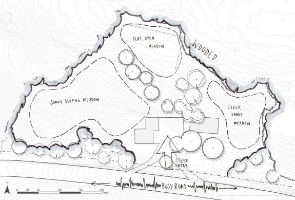
Shepard Farm is a property with a lot of frontage along Otis Stage Road, and a lot to see; the homestead, the pond, and two existing trails all have potential as points of entry onto the site. While there are informal vehicle pull-offs located at all of these areas, they are located immediately adjacent the high-speed State Route 23, are relatively narrow, and are liable to be washed out or muddy during rain events. Furthermore, the steep grade leading up to the homestead and meadow makes achieving all persons access a challenge. This document will follow the US Forest Service guidelines for the creation of all persons trails, which generally limits walking paths to a slope of 5%. For steeper slopes, rest areas and length limits are imposed.
Identifying Potential Parking Areas

There are five areas along Otis Stage Road that, due to both existing (if insufficient) infrastructure and proximity to points of interest, have been identified as potential access points. The driveway (A) leads straight to the historical homestead; between the barn and the house is a paved area that could form the foundation of a parking area. However, the grade of the driveway leading up to that area sometimes exceeds 20%, which is well above what is considered safe for vehicles. Ideally, the driveway would not exceed 10% grade, and the entry and exit of the driveway would be at 5% grade (or less) for the first forty feet.

To the east of the driveway is a pull-off (B), which allows vehicles to park without encountering the driveway. However, the surface of the pull-off is muddy gravel, and large, fast vehicles traverse Route 23; entering the site from the pull-off requires a walk adjacent to the vehicle traffic. Additionally, while the pull-off allows vehicles to avoid the steep topography leading up to the meadow, people still have to make their way up the hill, which can be a challenge for many. Three other pull-offs of a similar character are found along the frontage, in front of the right-of-way for the Springfield Water and Sewer Commission (C), the pond (D), and the trail leading to the stream (E). While the condition of these pull-offs are similar to those of (B), access to the points of interest (the trails and the pond) are not inhibited by the presence of steep topography.


Examining Ideal Access Conditions
Access would ideally minimize both ecological impact and cost. A regraded vehicular entry to the homestead area would bring visitors into the heart of the site and off of the busy road, thus kick-starting their experience. It also allows visitors to avoid a steep walk up the hill. This option would require earthwork to meet ideal grade, and would be relatively expensive (see sheet 14 for a breakdown of potential access costs).
Alternatively, regrading and resurfacing the existing pull-offs could save on cost and impact. Access in this scenario would be less direct, however, and would require a pathway from the pull-off to the homestead and meadow area; this could be graded for all-persons, making the walk up the hill a more reasonable endeavor.
Summary Analyses
A site with rich history and ecology but challenging access
Shepard Farm is in many ways representative of the historical themes of Blandford and much of New England. The site exhibits successional landscapes that tell the story of its past land uses as a respite for travelers, pasture, timber harvesting, and as water supply company lands. The site has high ecological integrity with intact forests and diverse wildlife, but people spend little time exploring either the forest or the meadow, due to poorly developed trails and access; to encourage use, interventions are necessary
The slopes of the site constrain comfortable walking for people of all abilities. Carving new trails here may require selective tree harvesting and earthwork.
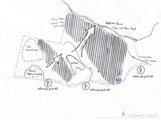
Watson Brook is a beautiful feature of the site. There is a flat trail from the road to the brook, but it will need to be resurfaced to prevent inundation after rain events.
The meadow is reminiscent of the cleared New England landscapes of the 1800s. This area can help tell the story of this site. The meadow is also the sunniest pocket of the site.
The existing driveway is too steep for cars and people to safely enter. Finding a new access point is essential to help people of all abilities access the homestead area.
The flat plateaus on the site provide areas to gather that do not require much earthwork. The challenge will be getting people to these areas while meeting all persons trail criteria.


