
15 minute read
Part One – Test Valley
Test Valley
PART ONE
Part 1 – Test Valley Winchester to Salisbury
150m
100m
50m
0m 0km 20km 40km
Distance: 40km
Highlights
Ascent: 468m
150m
100m
50m
0m Be aware 0km
5km 10km 20km16km
• An amazingly rich range of landscape history from ancient to modern. • Joining two historic English cities. • Quiet, mixed surface riding with relatively simple navigation. • Setting the scene for the full route. • Sheltered tree tunnel riding. • Optional extra woodland detour at the start at Farley Mount.
Navigation
You’ll need to keep your wits about you following the twists and turns out of Winchester itself, but after that the route is relatively simple as long as you check your map/GPS regularly. A rich network of quiet roads will soon get you back on track if you do lose your way. The off-road climb onto Broughton Down (OS grid ref: SU 295 325) 200m is steep and can be tricky in bad 100m weather. It’s worth it though. 0m The Roman road descent from 0km 10km 20km Middle Winterslow will definitely need caution in the wet too. 300m Occasional short, steep climbs and 200m 100m fast, loose, and narrow descents 0m in other places. 0km 5km 10km Crossing the busy A30 outside Salisbury needs care. 300m The sections of trail before and 200m after the A30 can be overgrown 100m in summer. 0m
0km 20km 40km 60km 33km
15km
86km
Area introduction and route summary
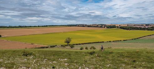
The first section of King Alfred’s Way is short but sets the scene perfectly for the whole route. Starting at the Westgate outside Winchester Castle, in the historic heart of the city, it rolls out into quiet suburbs which soon open up into a timeless rural landscape of singletrack roads and ancient tracks. You’ll climb and descend gradually past prehistoric barrows and earthworks, through medieval farms as castles and ancient churches gaze down from the high ground. There are plenty of opportunities to wander off the main route into the woodlands and hidden valleys of Farley Mount or add an early pub or shop stop into your meanderings. After criss-crossing the rich fishing heritage and history of the beautiful Test Valley, one of the first stiff climbs on the route takes you up onto Broughton Down. A short detour to the butterfly- and orchid-loaded nature reserve at the summit will repay your efforts with incredible views of the ride done and the ride to come. You’ve also earned a long descent afterwards.
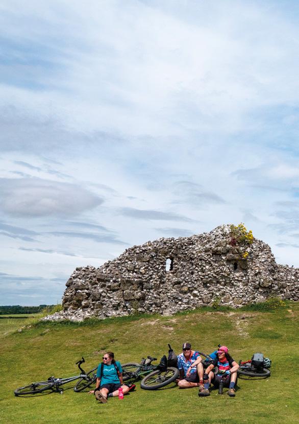
From here, the Roman road guides you on an undulating ride through quiet farmland, diverting briefly to avoid a main road and offer a brief glimpse of some chilling wartime history on the horizon, before arriving at the 2,500-year-old ramparts of Old Sarum fort on the edge of the thriving city of Salisbury.

Winchester
The county town of Hampshire has been an important settlement since the Iron Age, when three separate hill forts sat on surrounding high ground. A larger central ‘oppidum’ (fortified Celtic settlement) was formed on the banks of the River Itchen just before the area was overrun by Gaulish invaders from modern-day France, and then the Romans. It continued to be a major seat of power through the Anglo-Saxon, Viking, Norman Medieval and later periods, with many stunning buildings and monuments throughout the town as well as the castle, cathedral, and several museums.
Winchester Castle
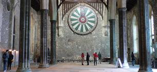
The foundations of Winchester Castle sit on a Roman fort built in AD 70 to control the local – mainly Gaulish – Celtic population of Venta Belgarum. The ramparts had survived well enough to be the obvious base for William the Conqueror to build one of his first Norman castles and a seat of government there in 1067. A central stone stronghold (keep) was added by Henry II to protect the royal treasury and the Domesday Book which were kept there. Having been born in the castle, Henry III added the formidable great hall where ‘King Arthur’s Round Table’ is now displayed. Dated to the 13th century, and with the names of the knights only added for Henry VIII’s benefit (King Arthur’s portrait is modelled on a young Henry), it’s about 700 years too late to be Arthur’s actual table, but it’s still an iconic symbol of English myth and power. Thankfully, the table and hall survived Cromwell’s demolition of the castle after an English Civil War siege, and it’s been a legal and civic centre for the city since the 17th century.
Winchester to King’s Somborne
Fittingly for such a rich historical adventure, the King Alfred’s Way route starts at the historic Westgate next to the castle. If you’re wandering around Winchester beforehand, it’s north west of the cathedral and war memorial and north of the Peninsula Barracks and Royal Green Jackets Museum, or just follow the heritage signposts to the top of the High Street. From the mini-roundabout straight in front of you, take the exit that puts The Westgate pub, with its iconic curved frontage, on your left shoulder. After a short section of busy street, you turn left over the railway bridge and head gradually up through a maze of quiet Victorian backstreets and leafy suburbs. A GPS will be useful here, but if you stay on track you’ll soon see the tall hedges lining the singletrack road are no longer hiding the outskirts of Winchester, but opening up to show the first views of the countryside.
Don’t get too distracted though, as you soon dive off down a narrow singletrack entry on the left within a kilometre. We can only imagine the tales that this narrow tree-canopied drove road, with its tight shrubbery and wild flowers, has seen unfold over its millennia of use, and this is just the first sentence of the first paragraph of the epic story of the route.
Winchester Westgate

Westgate is one of two surviving gates from Winchester’s medieval city walls. The earliest parts of it are Anglo-Saxon and it also has England’s earliest recorded gun ports for hand-held cannons. Unfortunately, you’re unlikely to get a medieval gunpowder salute as you set off, but the museum inside has an interesting display of exhibits and a Tudor painted ceiling that’s well worth a look.
Farley Mount diversion
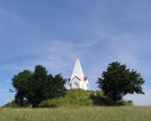
Farley Mount is a beautiful area of woodland walking and cycling trails on the northern slope of Pitt Down with big areas of broadleaf trees as well as open grazing with wild ponies. It can be accessed by a road or two bridleways from the King Alfred’s Way route south of Sparsholt. After exploring the woods, head for the car park to the south west and follow the track towards the Farley Mount monument, at the summit of one of the highest hills in Hampshire. This charming white spired folly is the resting place of ‘Beware Chalk Pit’ – a horse which managed to survive a fall into a 25 foot (7.5m) deep chalk pit, recovering well enough to win a race the next year and enter local folklore forever. The short bridleway past the Bronze Age barrows and through the woods on Ashley Down is a properly spirited gallop too. From there, you descend through Ashley on the road to rejoin the official route at King’s Somborne.
If you’re staying on track at Sparsholt, the official route carries on gently weaving through the trees as rough road turns to gently climbing ‘dual cabbageway’ double track. Then it’s back onto ‘real’ rural roads which ease you into a gentle roll down a wide valley between rich hedges. Bronze Age bowl and disc barrows hide their ancient secrets under the rolling grass meadows around Sparsholt and this tiny village is typical of many that you’ll pass. The name comes from “wood where spear shafts were made” and with the remains of a Roman villa lying in the adjacent fields, its roots stretch right back into time. You’re never far from villages like this all the way to Salisbury either, so even if you skip Sparsholt don’t worry about running out of supplies or chances of a warm welcome and pleasant rest. Just don’t stop at all of them or you’ll never get to Old Sarum, never mind all the way back round to Winchester. Whether you divert north into Sparsholt or not, the route carries on through the historic brick and half-timbered buildings of Moor Court farm. With a vast canopy of sky above, the route is exposed to weather here. That means paying attention to what your front wheel is doing as the road starts to crumble before turning into double track. While you’ll skim along skittering grit to the tune of skylarks on a dry summer’s day, wheels will definitely turn slower in the wet, so factor that into your estimated speed and timetable as well. Grumbling legs will be pleased to find a firm footing is restored after a short steady climb up onto the ridge above Up Somborne. Then it’s an easy cruise along more singletrack road past the aptly named Chalkvale Farm, under the watchful eye of the castle remains and manor house of Ashley to the south, before rolling into King’s Somborne.
King’s Somborne to Old Sarum
Once situated deep inside the hunting park set up by 15th century political powerhouse and father of the house of Lancaster dynasty John of Gaunt, King’s Somborne is now noisily split by a relatively busy road that requires some care after coming off mile after mile of deserted backroads. The half-timbered, thatched roof Crown Inn provides suitably regal themed refreshment opposite the village green and, traffic aside, it’s a quintessentially English spot for a quick stop. John of Gaunt has also given his name to the pub in Horsebridge, just off the main road where a narrow stone bridge takes you over the broad and shallow River Test. From here, you cross multiple shallow tributaries and ponds that typify the Test Valley landscape and show why it has always been a draw for visitors, royal or otherwise. If you look up, you’ll realise it’s time for the route to have some sport with your legs in the shape of what one of our local advisors calls a ‘horrific climb’, pulling you up 80m onto Broughton Down. If it’s wet, both
Test Valley
With the shallow, winding River Test cutting through the chalk lands of the North Wessex Downs Area of Outstanding Natural Beauty, this area is well known for some of the best salmon and trout fishing in Britain. Since 1822, it’s been home to the exclusive Houghton Fishing Club and was described by Lord Crickhowell as an area that “should be treated as a great work of art or music.”
surface and slope are all working against you here, so be prepared to dig deep or just get off and take your time gazing up at the massive trees with their overhanging roots that border the sunken track. Thankfully, the chalk grassland nature reserve and cluster of tumuli just a few metres off the route at the brow of the hill are a perfect place to sit and recover among the many rare insects and butterflies that live here. You’ll be able to see northwards right across the Test Valley to Danebury hill fort in the distance.
Danebury hill fort
Danebury is one of the most intensively excavated hill forts in the UK and the archaeological evidence from those digs forms the backbone of our knowledge of these iconic structures. Growing from a single ditch with wood-faced ramparts and a gatehouse, in around 500 BC the fortifications were increased in size as its importance – or the amount of disturbance in the local area – grew. By 400 BC the ditch was 6m deep and 12m wide, with a 10m rampart and flint wall towering above. Not only would that have made it a serious stronghold, but it would have projected the power status of the occupants right across the Test Valley. It’s notable that other local forts were abandoned around this time, while Danebury developed more complicated entrance earthworks and then a whole extra ditch and rampart ring. The amount of buildings also increased to form a small self-contained settlement of around 200-350 people. Multiple gate-burning incidents, as well as burial pits containing bodies with combat wounds, prove these defences weren’t just for show either. Despite its size and obvious importance, like most surviving forts Danebury was largely abandoned by 100 BC, and there’s no evidence it played any part in the Roman invasion.
Your efforts on the climb are now repaid in full, with a relaxed roll down westwards, overlooking rich farmland and old woods. The mixed gravel surface turns to dirt double track alongside Noad’s Copse which can make things trickier in winter. From Middle Winterslow the chalky clay-rutted byway of Monarch’s Way doesn’t seem that regal now. The long, sunken, slope-sided descent it turns into definitely deserves respect and caution even in the dry. The almost dead straight alignment gives away its origins as a Roman road but it’s certainly not dead flat as you winch your way past Firsdown. Don’t get totally fixated on your front wheel though, as the views of Salisbury and the Neolithic and Iron Age site of Figsbury Ring are beautiful. More recent and more sinister history hangs over the chemical and biological weapons research centre at Porton Down on the horizon to the north too.
Busy traffic is more of a concern as the modern world comes at you with a noisy rush at the A30. It’s only a quick scuttle across before you’re back into a tight tunnel of undergrowth again, diving down under the railway. From here, you turn left off the Monarch’s Way, briefly following the line of the River Bourne (more of a stream) south before rejoining the Roman road alignment for the last couple of kilometres past Old Sarum Airfield.
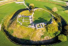
With just under 40 kilometres and a reasonable amount of climbing now in your legs, Salisbury itself, just to the south, is an obvious break and/or stopover point if you’re not pushing the pace. Either way, be sure to pedal up the entrance road between the huge grassy ramparts of Old Sarum as you’ll soon appreciate the sheer scale of this very significant Iron Age and Early Medieval site once you’re inside. You can visit the remains of the Norman castle in the centre, which is free if you have English Heritage membership, or you can buy a ticket on the gate.
Even if you don’t go inside, if you sit on the grass outside the keep, you’ll be on the first piece of an intricate archaeological jigsaw that’s about to surround you as you continue onwards through the World Heritage site of Stonehenge and Avebury.
Porton Down
Porton Down research camp was hurriedly created in WWI to develop protective equipment against the horrors of poison gas warfare as well as develop the UK’s own weapons. Thankfully, neither its research nor products (including anthrax and other biological weapons) were used in either of the World Wars but it was very busy during the Cold War, playing catch up on research and development of the nerve agents created but never deployed by Nazi Germany. It was the birthplace of VX nerve gas and CS crowd control gases, and is still one of the most secretive and heavily protected military sites in the UK.
Old Sarum Airfield
If you fancy swapping your handlebars for a joystick for a while, Boscombe Down Aviation Collection has a varied display of aircraft cockpits as well as complete planes to look around. Having been the centre for RAF Army Co-Operation training, the old operations centre and map room are now the offices of Wessex Archaeology, so don’t be surprised if you see Phil from Time Team wandering about.
Old Sarum
You won’t find many places with more of a concentrated compilation of history than Old Sarum. Starting as a large multi-ring hill fort in the Iron Age (400 BC) it became the Roman settlement of Sorviodunum, with three major roads meeting at the east gate. As the town outside its walls grew, it became the site of a Romano/British temple and the continued importance of Salisbury meant it was home to a mint at the end of the Anglo-Saxon area. It was the obvious site for a Normal castle as soon as they invaded, and a cathedral was then built inside the ramparts with several expansions of both castle and cathedral in the next century. Things had got very cramped by the start of the 1200s though, and when the cathedral moved into town the importance of the castle declined too. It was empty and stripped for stone by 1500.

Salisbury
While there is evidence of settlements in the Iron Age, Roman and Saxon periods, Salisbury as we know it is relatively recent. The grid pattern town was rapidly built around the relocated cathedral as Old Sarum was abandoned, and it became a city in 1227 and the largest in Wiltshire

by the 1300s. The Parliament of England met at New Sarum three times in the 1300s and a city wall was built from the cathedral and wall remains of Old Sarum in the same period. It’s been an important city for the region ever since.


