8 minute read
NHS Frontline

from Village Tribune 127

It’s OK not to be OK.. Supporting Mental Health
NHS Haematology Specialist Saqib Farooq writes from his Castor home.
Advertisement
The mental wellbeing of workers has become a key issue during the coronavirus pandemic. Whether furloughed, working from home or facing new lockdown conditions, many of us are finding that the uncertainty surrounding the pandemic is taking a toll on our mental wellbeing. According to data from the Office of National Statistics people experiencing depression in the UK has doubled from the previous year, with one in four reporting symptoms of depression after nearly a year of lockdown. This has put onus on employers to take stock of the mental wellbeing of their staff and find ways to help employees at all levels in an organisation through what is, for most, a difficult time. My own organisation, the NHS, is performing so far beyond what we consider normal at the moment it’s sometimes easy to forget that ‘health’ is what we do for ourselves too.
With this in mind, I asked a number of employers, how they are helping staff maintain their wellbeing during the pandemic and what support plan they have in place for those who need it most. The most impressive response and plan was, as précised below, from our Peterborough City Council: At the outset of the first lockdown PCC set up a health & wellbeing focus group (across Peterborough and Cambs County councils) to focus on our staff. We had in place external training for all staff on Mental Health & Wellbeing with a view to provide advice, guidance and training on what we are (and aren’t) in personal control of and how we can help ourselves. This training was also set up for Members too.
We undertook immediate and regular all-staff surveys to understand how people felt about themselves mentally and physically, their home-work situations and equipment, coping with technology use and potential isolation issues and as a result put in place an action plan to address themes coming through - this has been ongoing throughout the pandemic. We augmented these communications further with general wellbeing and another around Equality, Diversity and Inclusion. We issue twice-weekly hints and tips with links to other activities taking place nationally i.e. Dry January or Mental Health Awareness Day to strengthen the messages we send. We set up a monthly wellbeing drop-in hour, again with specific themes (general hints & tips and signposting to supportive information; back care awareness and guidance; an hour to be happy - focused also on relaxation, exercise and alcohol awareness in December) - all of this action has been very positively received by staff and members, especially those home-schooling their children or caring for elderly relatives and other domestic circumstances impacting upon their daily life. More generally, the council’s website has FAQ's regularly updated as government guidance changes in reaction to the issues ongoing, so as to remain relevant and a go to place for information. All this and much more besides points to an organisation which cares deeply and proactively about its people, their health and well-being and state of mind during this dreadful time. Nationally, as part of its campaign to address this mental health crisis, Mind has created an online coronavirus workplace hub with advice on supporting staff, managing furloughs and redundancies, team bonding and building closeness - especially when people are not in the workplace. If you are facing any of these issues or difficulties, please do not hesitate to reach out for help. It is perfectly ok not to be ‘OK’.

Write Away
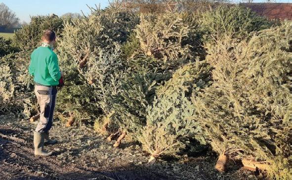
Alastair Peat Thank you to all those who supported the Xmas tree recycling for Helpston school... 86 trees collected and £515 raised for the school.... some super generous extra donors in there too... They are all being recycled by Tom at Boughton Landscape and Fencing who has chippings available should you need them... Stay safe everyone! A very happy new year to you and yours, and let’s hope, a Covid-free one. I just wanted to say a big thank you for highlighting Nina Vergette’s 100th birthday on the Friendship Club page, and thought you might like to see this picture of her. Doesn’t she look amazing! Many thanks one again. Barbara Holdich
As promised, I've managed to have the antislip measures installed on the footbridge steps at North Fen Road in Glinton, following residents' comments about safety. Sorry it took a while but the treads were on a back order. The top steps should arrive in a few days too and be fitted duly. Peter Hiller

Nice to see some new pebbles on the Pathway of Hope in Glinton today. We live in hope... Anne Lees
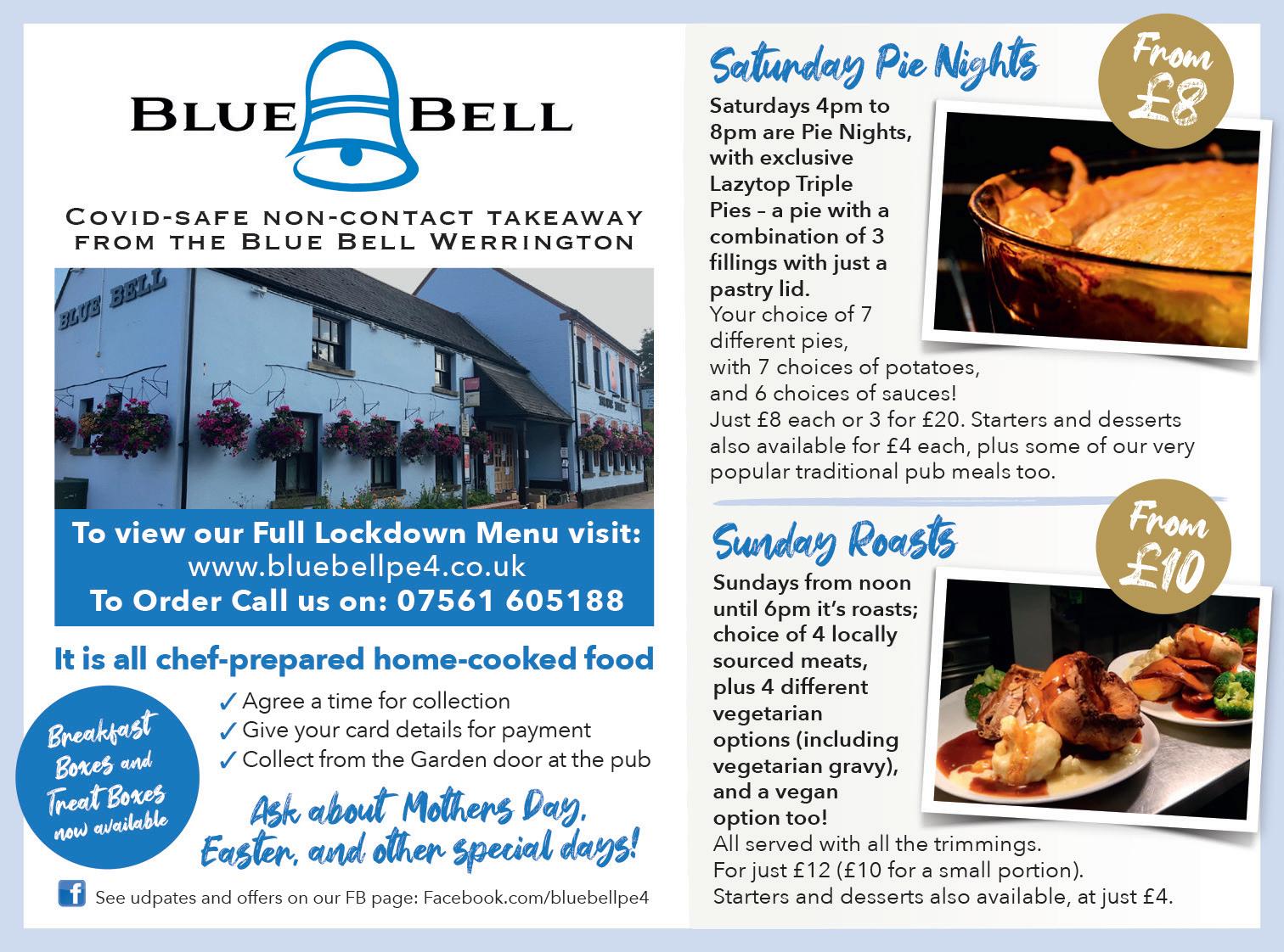
Willow Brook Farm
Wholesome Lunches
Homemade Cakes
Hearty Breakfasts
Afternoon Teas
Sunday Lunch
Pre-order Takeaways Open for the spring, restrictions permitting, with an additional marquee erected on the front of the Granary Scotsman Lodge, Helpston Heath, Stamford Road, Peterborough PE6 7EL
/ The Granary Tearoom Cafe | mandff arms67@gmail.com | 01780 749 483

TRIBLAND’S ‘MEADOWS’
From “A Topography of the Lower Welland Villages” (currently in revision)
Before Enclosure started in 1819, some 537 acres of low-lying land between Tribland’s villages was bounded by low earth banks. A large beautifully detailed map of the land between Lolham Bridges and the North Fen was discovered by archaeologist Tracey Partida in 2012 misfiled under ‘Marholm’ at the Northampton Record Office. Dated by Tracey at about 1580, it shows the early embankments that protected the land to the north and south from the meadows liable to flood between Northborough and Maxey to the North, and Etton and Glinton to the south.
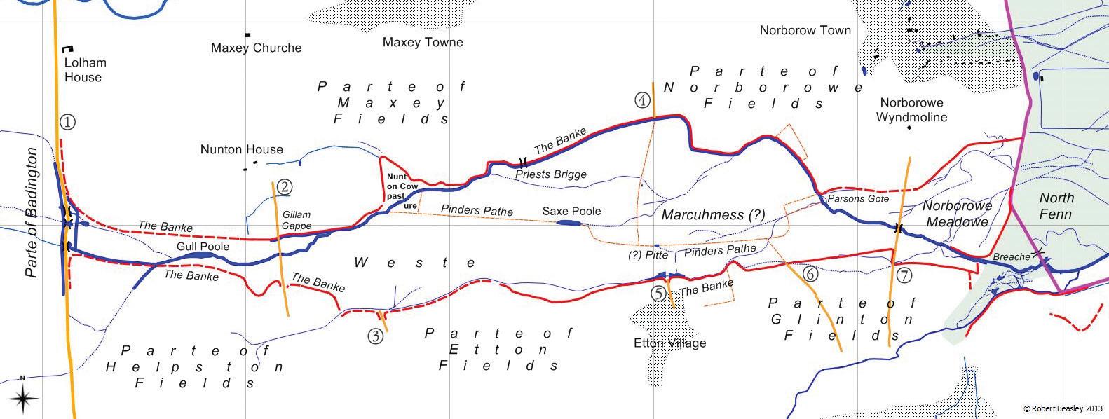
My transcription of the 1580 map onto an ordnance Survey grid. Where marked (?) there is some uncertainty as to the interpretation of the text
1. (King Street) The way from (rest
undecipherable). Three bridges are shown in the positions indicated and may not be the current 17thC bridges.
2. The way from Helpston to
Maxey. This road is on the line of the existing road from Helpston to Maxey Church and appears to go over the northern bank at “Gillam’s Gappe”. There would presumably have been a bridge over the river but this is not shown. Perhaps there was just a ford.
3. Sam Bense gate waye
(transcription not certain). This does not align with a modern road but does align with a modern field boundary. The map starts at Lolham Bridges in the west and ends at Carr Dyke and the North Fen in the east. The original map is discoloured right of centre, and very faded in places. While most of the writing on the map remains quite readable, there are some words that defy confident transcription. On the original, the banks have been colour-coded, yellow to the northwest, green to the southwest and red north of Etton. Perhaps the purpose of the map was to indicate responsibility for maintaining the banks? Within the banks some boundaries or paths are marked (e.g. “Pinders Pathe”) which correlate approximately with today’s parish boundaries
TRIBLAND’S ‘MEADOWS’
By Robert Beasley robertbeasley155@btinternet.com
4. Maxey Drifte. This is on the line of the modern road to Etton but does not continue south below the northern bank. 5. Not named but enters Etton from the bank to the north, on the line of the existing road. 6. Highgate Way. Not aligned with any modern road
7. The way from Pet boro brigge to mkett Deepinge.
This road ran about 220m east of the modern road to Northborough. There is still a dip in Mile drove just where the bridge or ford used to be. Was ‘Peterborough bridge’ the bridge over the Nene in Peterborough?
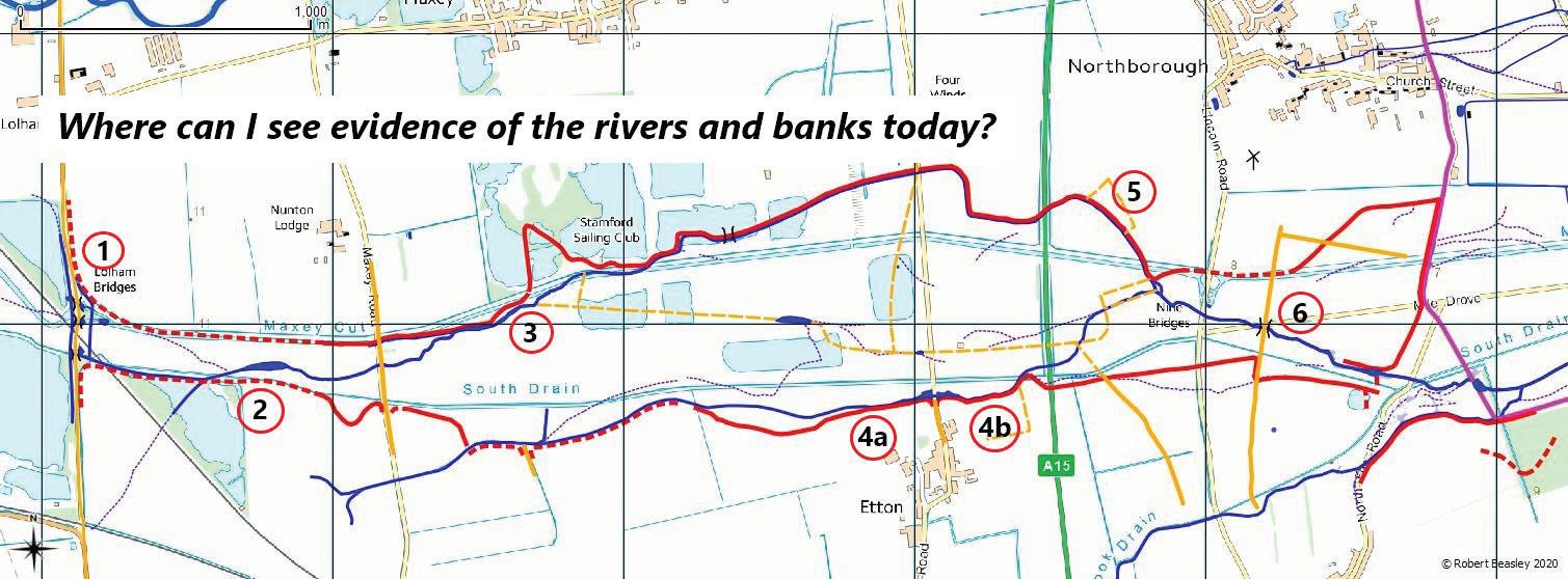
Draughtsman Thomas Clerke must have surveyed the whole area with some diligence because he annotated the drawing at the bottom left corner with a pair of dividers and a note that he has drawn it to scale. Fieldwalking, and RAF and Google aerial photos reveal the positions of the banks and other features shown on the 16thC map and this has allowed them to be transcribed onto a modern Ordnance Survey map. 1. Looking east from King Street at this point, the original bank (or an uprated version of it) can still be clearly seen. If the map is indeed 1580, the bridges shown are unlikely to be the existing bridges. 2. “Gull pool” exists today as a muddy depression in a field. 3. The clearest and most obvious evidence of the river can be seen in a spinney at this point. The preserved riverbed is still a meter or two deep and several meters wide. Turn down Woodgate Lane in Maxey and turn right onto the south bank of the Maxey Cut and travel west about three hundred meters to see it. 4. When the fields are newly ploughed, look south from the south bank of the south drain at these points. The medieval banks can still be seen as slight ridges.

The original map entitled The Plott of Westins Meaddow & Marrlamme(?) with the Towns Adjacent from the North Fenn to Lolham Bridges drawn by Thos: Clerke


