Estonian industrial enterprises and scientific research establishments have experience in the creation of space technologies and the development of space equipment for decades. Estonian membership in the European Union and in European Space Agency (ESA) has opened new avenues for businesses that have potential in space affairs. Moreover – operating in space affairs helps increase the influx of technology-intensive investments and improves the synchronicity of science and business, helping it to develop into an interdisciplinary field. Cooperation with ESA presents Estonian enterprises and scientific establishments with a unique opportunity to participate in ESA’s fast-moving technological development, with results that can also be implemented in Estonia. With the help of ESA optional programmes, we can support the development of the Estonian technology sector.
Cross-border cooperation is one of the most important preconditions for achieving the objectives set out in Estonian Space Policy and Programme 2020-2027 The main goal of the space policy and programme is to create an improved environment for Estonian technology companies and to increase their competitiveness. Estonia’s activities in the space domain will help our companies to integrate into the supply chains of major system integrators as well as facilitate the development of local integrators framework.
One of the main tasks of the mapping exercise at hand was to develop an understanding of the skills and competencies of the Estonian industry and how these skills could fit into the global space ecosystem. The information gathered will serve as an input to creating measures that are going to support the diffusion of technologies already used on Earth to space and vice versa.
The mapping exercise will continue, and new technology descriptions will be added when they occur. Further actions will be coordinated by the Estonian Space Office. We titled the document Estonian Space Directory to encourage readers to get in touch with their potential partners.
Madis Võõras Head of Estonian Space Office
Estonian Business and Innovation Agency
Welcome to the Estonian Space Directory, where you can explore Estonia's growing capabilities in the space sector. Estonian space industry is rapidly expanding, and this directory serves as a guide to Estonian companies and organizations involved in the development of space technologies.
The Directory is divided into four main categories: Ground, Upstream, Downstream segments and R&D service providers. In the Ground segment, you will find companies and organizations involved in the construction and operation of ground-based infrastructure. The Upstream segment includes companies involved in the development and manufacturing of satellites and other space-related hardware. The Downstream segment includes companies and organizations focused on using space-based data. Finally, in the R&D service providers segment, you can find companies who offer technology development as a service.
Estonia's space industry has already achieved notable success, even though it is relatively young. Through this directory we aim to showcase the diverse range of capabilities within the industry. Whether you are a researcher, investor, simply curious about the exciting developments taking place in the Estonian space sector, or looking for business partnerships, the Estonian Space Directory is the perfect starting point for exploring the country's capabilities.
The document at hand is not a comprehensive overview of Estonian Space Technologies. However, it serves as a live document, which is updated periodically. We encourage Estonian space sector stakeholders who feel their technology descriptions could be included here, to get in touch with the Estonian Space Office and have their technologies included in the next revision of this document.


The technical readiness level of the technologies is assessed by the widely used technical readiness level scale. The scale is defined in the table below:
TRL9 actual system proven in an operational environment (competitive manufacturing in the case of key enabling technologies; or in space)
TRL8 system complete and qualified
TRL7 system prototype demonstration in an operational environment
TRL6 technology demonstrated in a relevant environment (industrially relevant environment in the case of key enabling technologies)
TRL5 technology validated in a relevant environment (industrially relevant environment in the case of key enabling technologies)
TRL4 technology validated in a lab
TRL3 experimental proof of concept
TRL2 technology concept formulated
TRL1 basic principles observed
CybExer Technologies offers a cutting-edge, NATO-awarded Cyber Range Platform engineered to meet the highest cybersecurity standards. Our platform delivers unmatched scalability, flexibility, and high availability, enabling clients to conduct complex and extensive cyber defense exercises without constraints. This empowers organizations to simulate real-world scenarios, train personnel, and test security measures in a fully customizable environment.
CYBEXER TECHNOLOGIES cybexer.com
CONTACT
Kristiina Omri
kristiina.omri@cybexer.com
+372 5668 2088
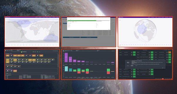
In collaboration with the University of Tartu Observatory, CybExer is at the forefront of cybersecurity innovation, developing a digital twin of the ESTCube-2 satellite. This twin replicates the satellite’s functions, allowing for comprehensive testing and enhancement of system resilience against cyberattacks, all while leaving the actual satellite operations unaffected. This cutting -edge tool is also used to train satellite operators, ensuring they are fully prepared for real-world threats.
Our Satellite Operations Simulator (SatOpSim) represents a significant advancement in cybersecurity training. Integrated within our advanced cyber ranges, SatOpSim provides a realistic, controlled environment for satellite operations. With live dashboards, control systems, real-time threat scenarios, and challenging tasks, participants gain the critical experience and skills required to secure the next frontier in space cybersecurity.
At CybExer Technologies, an Estonian-based leader in cybersecurity, we offer advanced Cyber Ranges utilizing digital twin-based testing and training environments. These solutions enable organizations to achieve cyber excellence by honing their skills in a simulated, risk-free setting. Our Cyber Range platform empowers organizations to anticipate and be fully prepared for cyber challenges, ensuring their cyber capabilities are at peak performance when the need arises.
The Science Operations Configuration Control Infrastructure (SOCCI) provides a platform to support the software development and maintenance processes of all SCI-O units at ESA’s European Space Astronomy Center (ESAC).
CGI EESTI AS cgi.ee
Sille Kraam sille.kraam@cgi.com
DETAILS
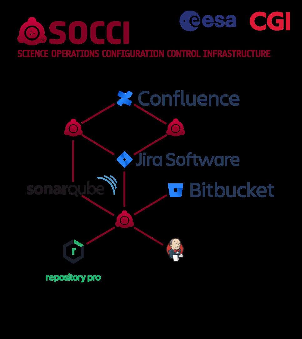
The Science Operations Configuration Control Infrastructure (SOCCI) is a single, highly customizable platform for system engineering, providing tools and guidelines for requirement management, problem and change management, test management, project and document management, source version control and continuous integration.
The infrastructure provides support to the software development and maintenance processes of science operations units at the European Space Astronomy Centre (ESAC). SOCCI reduces effort and knowledge to setup and maintain the Systems Engineering Environment and supports the users by providing guidelines and good practices learned from previous experiences. SOCCI also reduces the need for ad-hoc development and facilitates the software engineering processes’ compliance with the ECSS standards.
The development of SOCCI started in 2014 and has being operationally used from June 2017. Recently, the range of functionalities already covered by SOCCI have been extended through SOCCI Evolution and SOCCI Test Framework projects. The user base of SOCCI is constantly growing – it is currently used by over 100 engineers from existing missions (e.g., INTEGRAL, BepiColombo, XMM, Athena) and the use of SOCCI is now mandatory for all new science missions.
The goal of the activity is to specify Mission Planning and Scheduling services in the context of the CCSDS Mission Operations Services standard. The main beneficiaries are agencies operating missions, system integrators and ground segment software providers who will use the standardized CCSDS services for the integration of the mission operation functions between their products.
EESTI AS cgi.ee
Sille Kraam sille.kraam@cgi.com

The Consultative Committee for Space Data Systems (CCSDS) is an international organization that supports collaboration and interoperability between member agencies through the establishment of space data and system standards. The goal of this technology development is to specify Mission Planning and Scheduling services in context of the CCSDS Mission Operations Services standard, and apply them in an operational context for validation and improvements. The activity started in 2013 as a PECS project and continued in 2018 through GSTP. As an outcome of the activity, CGI obtained a good overview of the mission planning domain through specification of the CCSDS MP services and development of a prototype external interface to ESA Mission Planning System Framework (MPSF) that implemented the MP services. In addition, CGI implemented the MP services in NanoSatMOFramework (NMF), the operating platform of ESA’s OPS-SAT mission. An OPS-SAT experiment was also developed that demonstrated on-board autonomy using the MP services. The purpose of the experiment was to enable autonomous, on-board decision making of an optical Earth observation satellite based on cloud cover.
Ground Segment Engineering Framework (GSEF) is a collaborative web-based model-based system engineering (MBSE) framework, developed under the Advanced Digital Ground segment Engineering (ADGE) activity, funded by the ESA GSTP programme and run by CGI Estonia in collaboration with CGI Germany, SpaceCube (Germany) and Solenix (Switzerland).
Sille Kraam sille.kraam@cgi.com
The objective is to provide an environment for digital systems engineering enabling system engineers at ESA to manage the complexity of engineering activities, work more efficiently and produce higher quality results through model-based approach.
Achievements and status: The ADGE system provides a fully web-based, SysMLv2 compliant MBSE environment to design, develop, validate and support operations of a full system lifecycle. The target validation context is ESA ground segment systems. The participants in the system are the mission engineers and any external domain specific tools and systems that contribute to the overall design, architecture, validation or operational activities.
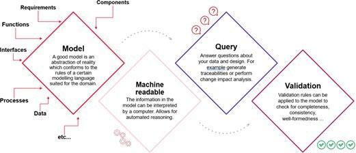
The ADGE functionality has been validated with systems engineers from the ESA EGOS-CC and PLATO teams.
Benefits: The framework provides a step-change improvement in efficiency through guided implementation of the engineering processes, capture and re-use of engineering data baselines and streamlined collaboration across domains. Advanced traceability, query and reporting functionality enable quick verification, completeness and constraint checks and customized views. Support to and population of reference libraries enables faster adoption and efficient re-use across projects.

KSI blockchain technology enables its customers to know and be able to forensically prove, whether any part of their systems or stored electronic data and logs have been changed, either by insiders, external actors, or technical malfunction. KSI blockchain provides a mathematically tamper-evident audit trail and evidence for post-incident investigations, establishing who, what and when with a forensic precision.
GUARDTIME guardtime.com
CONTACT
Kaarel Hanson Space Program Manager kaarel.hanson@guardtime.com
High-scale, high-frequency blockchain technology for real-time integrity instrumentation of systems, networks, processes and data. KSI blockchain allows to register and verify 1012 data items every second, with high availability (99,999%) and 100% data privacy guaranteed. KSI signatures are server based, meaning that signing data requires online access to the KSI service. The verification of the signatures can be done both offline and online. There are two options for access to KSI:
1) KSI Software Development Kit (SDK)
2) Catena middleware
The KSI SDK provides the lowest level of integration. It enables “full access” to the KSI functions (signing, extending, verifying) and lets the integrator fine-tune all possible options. As a consequence, it leaves many common challenges, such as signature storage and extension, to the integrator to solve.
Catena is middleware that is meant to address common integration challenges, such as asynchronous signing, signature persistence, and automatic extension. It provides the integrators with higher-level functionality, such as annotating signatures and linking signing events (data provenance), in order to reduce the effort for building a complete solution. Catena internally uses the aforementioned SDK to perform low-level KSI operations. The functionality of Catena is grouped and packaged into logical applications (Catena-KSI, Catena-DB, Catena-Prov) so that the integrator can choose which ones to deploy and use. KSI SDK and Catena are not mutually exclusive: they can be used in combination if needed. This depends on the application type and the requirements for signing and verifying data. Use-cases trusted audit trails: Space systems, from satellites to mission control centres, are frequently the target of cyberattacks.
KEY INFORMATION
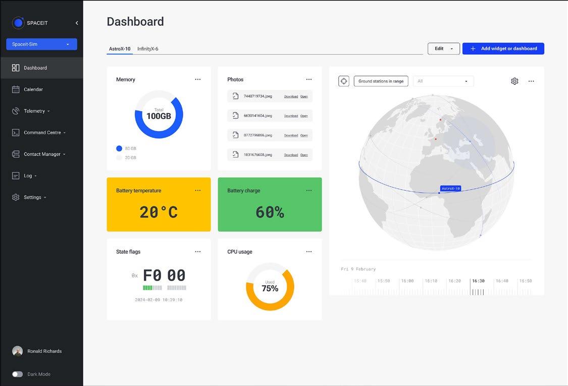
Spaceit provides satellite operations as a service. Gone are the days when satellite missions required an army of engineers. Spaceit makes space access affordable, leveraging efficient resource use, extensive ground station connections, and a flexible pay-as-you-go pricing model. Spaceit Platform ensures satellite missions benefit from automated operations, low latency, high data rate, and high reliability combined with top-notch security.
SPACEIT
www.spaceit.eu
CONTACT
Silver Lodi CEO
silver.lodi@spaceit.eu
• Mission Control System - Software platform for satellite operators looking to manage all their assets and related processes in a single application environment.
• Ground Station Marketplace - Integration with various ground station networks ensures broad coverage and minimal delays for near-real-time data delivery. It covers contact management, booking, and service and price optimization.
• Telemetry Processing - Limit checking, alarms, and notifications, telemetry parameter mnemonics, and synthetic telemetry parameters.
• Advanced Telecommanding - Session-based command queues, stored telecommand sequences, event and time-based telecommand execution, and telecommand validation based on telemetry values.
• Event-Based Automation - An automation system accessible directly from the Spaceit Platform's user interface, allowing for actions to be executed on specified events, with immediate notification in case of failure.
• Extended Dashboards - Templating for dashboards and event-based activation of dashboards.
• Advanced Communication - File uplink functionality and automated retransmission of corrupted/missed packages for uplink and downlink.
• Mission Log - Records events created by the system and users in the mission log, with search and filtering capabilities.
• Asset Configuration and States - Supports a wide variety of input formats for asset configuration, integration with Git, and asset state management based on telemetry, events, and user entries, with search and filtering of asset states.
• Online Payments - Built-in capability for online payments for mission control and ground station services.
• Seamless Integration - Integration with third-party solutions (e.g., flight dynamics, mission planning, etc.).
• Satellite Platform Agnostic - Supports various satellite communication protocols e.g., CCSDS, CSP, AX-25, etc.
• Cloud Agnostic - Can be hosted on AWS, GCP, private clouds, or on-premise
• Crafted for Users - Prioritizes user-centric design, ensuring an intuitive and seamless experience. All are tailored to enhance your workflow
From antenna design and electronic component selection to signal boosters and more, Rantelon is capable of designing to clients needs. It can be for your satellite television or the newest 5G networks.

RANTELON rantelon.ee
CONTACT
Karl Taklaja Head of Sales karl@rantelon.ee
Rantelon has a long history of creating telecommunications devices. The first devices ever produced were DVB-T amplifiers. Nowadays we design and produce a large range of different devices. Mostly we operate in the private area network of infrastructure devices. We have made different products for government and private entities. One of our biggest partners is EXFO OY for who we make a wide range of 3G and 4G devices. For governments we have made devices for TETRA networks.
Intelligent and automated C-UAS based on RF detection, Edge AI and jamming.
Figure: Rantelons drone detection system DTS-2458
RANTELON rantelon.ee
CONTACT
Karl Taklaja Head of Sales karl@rantelon.ee
Rantelon develops technologies for detection, identification, and neutralization of commercial unmanned aircraft systems (UASs). Such UASs typically utilize the industrial, scientific, and medical (ISM) radio frequency (RF) bands for remotely controlling the UASs from a ground station. The developed counter unmanned system (C-UAS) technologies rely on detecting, identifying, and neutralizing those remote-control signals and also the signals that travel in the opposite direction, from the UAS to the ground station. In addition, Rantelon has integrated into the C-UAS systems the capabilities to prevent UASs from using different global navigation satellite systems (GNSSs) in order to prevent malicious UASs from carrying out pre-programmed missions while relying on GNSS for navigation.
Data management and artificial intelligence are key aspects of Rantelon’s C-UAS research and development efforts. That is because the principal challenge in detecting and identifying UASs using RF sensors is distinguishing between the different signal waveforms used by different UASs and other spectrum users that are not necessarily UASs. Artificial intelligence provides an efficient and accurate method for classifying between those different waveforms used by UASs and other spectrum users Indeed, AI based systems are outperforming classical identification systems in a wide range application. Data management and data gathering, on the other hand, allow to build the artificial intelligence models and attain necessary accuracy.
Continuing from the technology selection from detection and identification to destruction, RF based neutralization is and most probably will be one of the primary concepts in countering adversarial remotely controlled UASs. This encompasses simple denial-of-service attacks through jamming but also more complex approaches through spoofing.
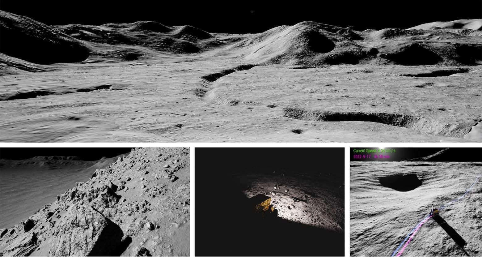
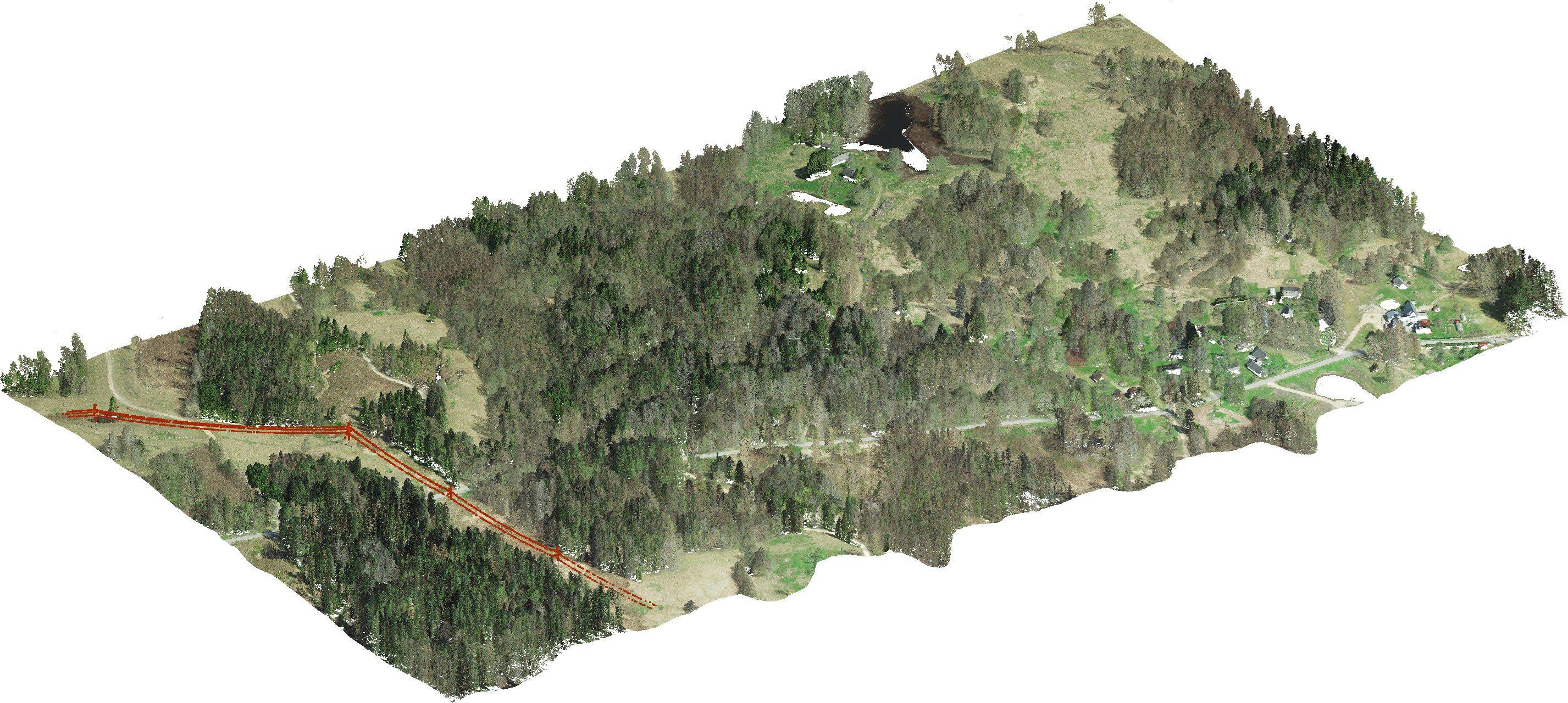
ULYSSES is a planetary surface simulator with the capability to generate photorealistic synthetic images and simulate planetary rover traversals along planned paths. The simulation environment is being developed to serve as a digital testbed for the development and validation of future robotic missions to the Moon, Mars and elsewhere in the Solar System.


CONTACT
Mihkel Pajusalu, PhD Head of Space Technology Department at Tartu Observatory, University of Tartu mihkel.pajusalu@ut.ee +372 5381 5711
DETAILS
ULYSSES serves as a sandbox testbed, aiding mission planning and software development for planetary rover missions. It leverages the powerful Unreal Engine 5 (UE5) for real-time rendering of expansive planetary landscapes, precise shadow rendering, and other tools of the game development engine.
ULYSSES was originally developed as a validation environment for the ESA contract (Nr. 4000134795/21/NL/CBi) "Operations and mobility planning system for Lunar rover missions", where strategic planned paths for multi-week Lunar surface traversals were validated and verified. ULYSSES has also been used to generate synthetic images for Lunarpoint - machine learning based feature detector and descriptor for Lunar Landscapes, showcasing its potential in producing ample synthetic data for machine learning. Current development of ULYSSES focuses on improving its terra-mechanic physics simulations, improved user-interface as a mission planning tool and integration of more robotic simulation tools with ROS-compatibility.
TRL 7 (used for missions, but not yet streamlined)
Simulation capability for modelling camera images for testing data processing, navigation and mapping algorithms for space missions.
DETAILS


UNIVERSITY OF TARTU, TARTU OBSERVATORY, SPACE TECHNOLOGY
Mihkel Pajusalu, PhD
Mihkel Pajusalu, PhD Head of Space Technology Department at Tartu Observatory, University of Tartu mihkel.pajusalu@ut.ee +372 5381 5711
We are developing a system to model photorealistic space imagery for fly-by, orbiting and surface missions. The system is built around Blender and its Cycles rendering engine.
The technology is being used on Comet Interceptor mission for OPIC instrument simulations.
Further, the imagery simulation is being used for Lunar rover prototyping efforts. The system itself can be accessed at github.com/SISPO-developers/sispo
A journal article is being prepared, but three conference papers related to its development have been released:
+ www.dropbox.com/s/5gxjjqw662rptiy/IAC-20.A3.4B.4.x61048_final2.pdf?dl=0
+ www.dropbox.com/s/d86pk4d36utj781/Latt%20et%20al.%20-%202020%20-%20 Converting%20an%20Industrial%20Autonomous%20Robot%20System%20i.pdf?dl=0
+ www.dropbox.com/s/gky4xtizx7ei1qg/M.%20Pajusalu%20and%20A.%20Slavinskis%20-%20 2019%20-%20Characterization%20of%20Asteroids%20Using%20Nanospacecraft.pdf?dl=0
TRL9 for some parts
KEY INFORMATION
Multiple antenna systems for satellite RF signal transmission and reception.
DETAILS
UNIVERSITY OF TARTU, TARTU OBSERVATORY, SPACE TECHNOLOGY
Viljo Allik, MEng
CONTACT
Mihkel Pajusalu, PhD Head of Space Technology Department at Tartu Observatory, University of Tartu mihkel.pajusalu@ut.ee +372 5381 5711
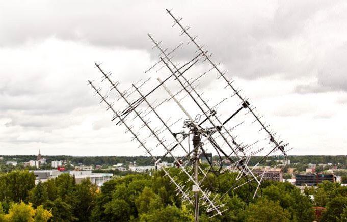
RF signals can be sent and received in the VHF, UHF bands. Exists S-band reception capability. Exists SDR capability and know-how. Radio-amateur compatible systems (AX-25 standard). Antenna systems are capable of tracking satellite passes.
INTELLECTUAL PROPERTY
IP belongs to University of Tartu.

LightCode Photonics is currently developing an innovative 3D imaging sensor which combines simple low-cost hardware with advanced statistical processing algorithms to achieve low-noise, high-resolution 3D measurements.
The dynamic pixel technology relies on the single pixel imaging concept. The computation load required to implement the dynamic pixel technology is lightweight and allows the camera’s hardware properties to be modified in software during its operation. The advantage of the technology lies in the ability to enhance the performance of existing direct time-of-flight array sensors to the levels attainable to the newest premium quality sensors with high native resolutions. The technology can also be combined with both affordable and accessible COTS (commercial off the shelf) sensors, and high-end, high-performance sensors available today.
Our hardware platform is easily configurable for implementation in various 3D-imaging use cases, such as short-range LiDAR, advanced driver-assistance systems (ADAS), stack height control, safeguarding minimum distances, object detection, collision avoidance for Autonomous Mobile Robots and Autonomous Delivery Vehicles. In addition, the solution can provide value to smart city applications. The applicability can also extend to space, e.g. docking and landing on other planets, providing vision for autonomous planetary rovers.
LightCode Photonics has started a collaboration project with ESA to validate technology suitability in space conditions.
LightCode Photonics is a science-intensive deep tech company developing breakthrough technology for smart machines.
We imagine a world, where routine work is automated and robots are handling tasks from city maintenance to parcel delivery, dangerous rescue missions and docking in space. Thus we are rethinking image acquisition and solving 3D imaging in a completely new way - via intelligent perception. LightCode Photonics is transforming 3D imaging from human-like perception to robotic vision - we are building the 3D camera using dynamic pixels.
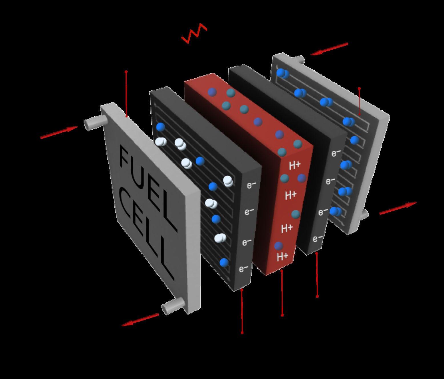
PowerUP’s fuel cells generate electricity through a chemical reaction of oxygen and hydrogen. Closed cathode fuel cells for space missions require oxygen and hydrogen to be supplied from a cylinder.
DETAILS

POWERUP ENERGY TECHNOLOGIES powerup-tech.com
CONTACT
Ivar Kruusenberg, PhD CEO and Founder ivar@powerup-tech.com +372 503 6963
PowerUP produces hydrogen fuel cell-based electric generators and proton exchange membrane (PEM) fuel cells. Its technology is used in sectors such as telecommunication, defence, construction, hospitals, and offgrid homes to name a few.
A fuel cell is a device that generates electricity by a chemical reaction, which requires hydrogen and oxygen. A single fuel cell generates a tiny amount of electricity, hence, cells are usually assembled into a stack.
Proton exchange membrane (PEM) fuel cells operate at a low temperature, which makes them suitable for homes, cars and other similar applications. Usually oxygen can be taken from surrounding air, but on Mars and Moon, there is no oxygen. Thereby, closed cathode technology is required. These fuel cells require oxygen to be supplied from a cylinder. PowerUP’s closed cathode fuel cells are lightweight and corrosionproof for use in Mars and Lunar cargo ships and rovers. The company has developed its own highly active bio-based and CO2-derived nanocatalyst. Industrial biowaste and CO2 are being used to synthesize a high surface area and highly porous nanocarbon supports which are further modified with metal nanoparticles. Closed cathode fuel cells are more efficient than open cathode fuel cells.
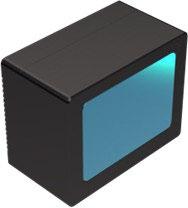
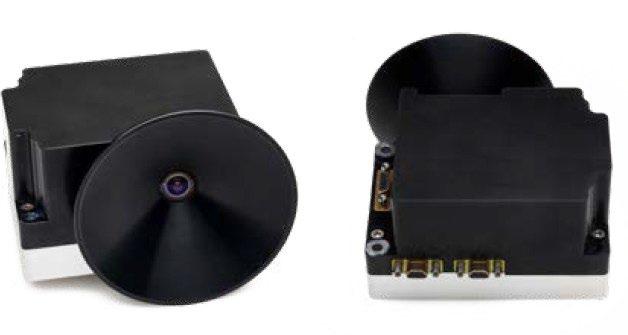
CrystalSpace develops and produces camera systems for Cubesats, New Space and High Rel missions. Our camera systems are suitable from 1U cubesats to bigger satellites and for landers and rovers on the Moon and beyond. CrystalSpace camera systems have capability to do up to 60fps in 720p resolution, work in Stereo configuration and many more features.
CRYSTALSPACE
Pätris Halapuu crystalspace.eu
CONTACT
Pätris Halapuu info@cystalspace.eu
Crystalspace camera “Suupistri” is ideal for monitoring & computer vision applications. It is the smallest and the most advanced monitoring camera on the market. Suupistri enables robotic & docking missions to get 720p quality feed at 60 fps.
Monitoring camera system “Kodas” is the best option for monitoring non-real-time operations. Use cases are: monitoring satellite deployables and their performance, monitoring separation and landing, as well as taking images for marketing and mission promotion purposes.
Nanosatellite cameras are the smallest and the most advanced CubeSat camera systems on the market. It suits well for densely packed CubeSats. Some of the use cases are: taking high quality images for PR purposes as well as monitoring satellite panels deployments.
CrystalSpace is a company that develops and produces camera systems for satellites and other spacecrafts since 2013. CrystalSpace cameras have flight heritage from numerous missions with the Moon lander and Moon rovers missions planned in the year 2024+. CrystalSpace develops camera systems both to new space as well as to high rel missions, following the ECSS standards. We are happy to discuss and review your requirements and find a way to provide a suitable camera system for you!
FPGA soft cores implementing a fully functional Hardware Security Module (HSM) which can be integrated to implement end-to-end hardware encrypted data communication for space applications. We demonstrated its functionalities via a VHF radio link by encrypting the CCSDS SDLS/TC/TM protocols.
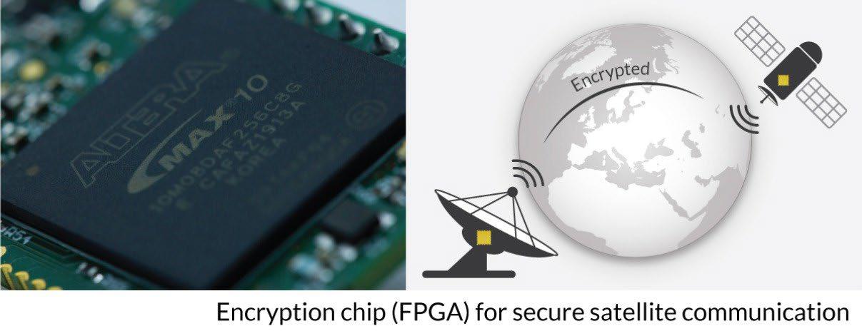

SKUDO skudo.tech
CONTACT
Stefano Alberico stefano@skudo.tech
Skudo is focusing on Cybersecurity solutions based on pure hardware encryption, rather than Software, as this guarantees the highest level of security for our customers. Our HSM (built within a single FPGA chip) is entirely verifiable by independent third parties. The FPGA chip is designed and implemented in Europe. While the Hardware Security Modules are widely available on the market and used in many applications, none of those chips can be verified to ensure they don’t contain any undocumented backdoors. This is where we differ from our competitors who have chosen “blind trust” towards the technology they propose.
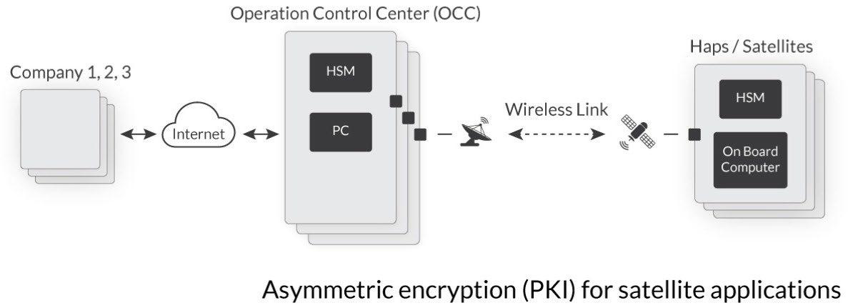
For ESA we are currently working on a PoC which will have our encryption FPGA chip launched on a strato balloon to simulate a High Altitude Pseudo Satellite (HAPS conditions) and demonstrating an asymmetric encryption data link (fully deployed by a PKI) working at an altitude of 25 km in the stratosphere. One of the next steps will be to integrate our solution on a satellite and demonstrate our SDLS/TC/TM encryption technology in a real space environment where also the Operation Control Center will be involved.
In the past, we have demonstrated our encryption chip by integrating it with a commercial drone system while encrypting its wireless telemetry link (using the MAVlink protocol) between the flying drone and the Ground Control System.
For the consumer market we are launching a PCB device which offers our fully functional HSM chip (FPGA) for the makers community (RaspberryPi, Arduino, integrators, etc.) skudo.tech/kryptor
In the near future, we plan to develop and increase the number of available soft cores while migrating them also to other FPGA brands (e.g., space graded). We also aim to design and implement custom built solutions for mission critical applications based on our chip. Among those we want to target IoT, drones and space applications to start with.
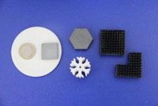
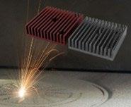
Our team designs and builds optimized solutions for Thermal Management applications: From feedstock formulation to additive manufacturing of end customized products.
Nowadays, most of the components face heat transfer problems; the geometrical and volume constrains limit the design possibilities of the traditional manufacturing technologies. To solve these problems we design ceramic and metal based formulations and optimize the additive manufacturing process to print geometrically complex structures. We manufacture final products based on ceramic and metal composites.

www.fact-industries.com
CONTACT
Marina Aghayan, PhD marina@factindustries.com +37255588124
Our team is developing and optimizing feedstocks for additive manufacturing; specialized in feedstocks for stereolithography (SLA) and selective melting laser (SLM). For SLM our goal is to obtain feedstocks with high flowability and sinterability. For SLA our objective is to increase the solid loading, achieving higher dispersion stability and greater photocuring. We offer customized formulations for additive manufacturing.
We also optimized the printing parameters for manufacturing the end-products by SLM and SLA. We are developing SiC and Si3N4 based composites solutions to handle heat dissipation.
Our small and yet expanding team is now engaged with several projects, partnered with industry leading businesses, and delivers robust and reliable output from materials design and characterization to small scale production line. Through different projects, from the initial stage with FACT-THERM project funded by EIT RM Booster, and more projects with the European Space Agency, our company has growth and currently we can provide composite materials for efficient and smart thermal management. We are developing ceramic packages for the aerospace applications and ceramic composites solutions for electronic components.
In addition, we can offer prototyping services to give cost effective and fast solutions to touch the designed model and apply final correction before applying costly manufacturing techniques. With our expert staff we can offer testing of thermal transport properties. Required geometries are decided based on sample type and expected properties. Contact us and we’ll find the best solution for your case.

KEY INFORMATION
High-quality supercapacitor energy storage for high-power applications. 300-5000F

DETAILS
SKELETON TECHNOLOGIES skeletontech.com
info@skeletonteh.com
Our patented Curved Graphene carbon material provides our supercapacitors with superior power and energy density in the supercapacitor industry, and this advantage carries over to our supercapacitor modules and systems.
We make our own Curved Graphene carbon raw material, and produce our supercapacitor cells, modules, and systems to strict quality standards, servicing our customers in automotive, transportation, grid and renewables, and industry.
The SkelCap SCX5000 is our next generation supercapacitor, taking full advantage of the Curved Graphene raw materials and offering high energy density in the most popular form factor on the market.
Voltage: 3 V
Capacitance: 5000 F
ESR DC: 0.2 mOhm
Specific power: 28.4 kW/kg
Specific energy: 11.1 Wh/kg

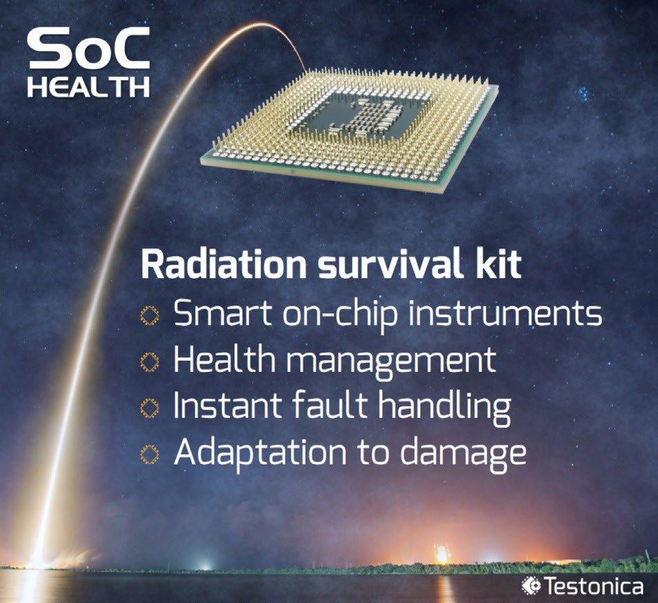
Self-Health Awareness technology that enables on-board realtime electronics integrity monitoring for instant fault recovery, prognostics, and adaptation to damage. Health Management software performs on-board analytics for telemetry data reduction.
TESTONICA LAB testonica.com
CONTACT
Artur
Jutman
Managing Director artur@testonica.com +372 517 9012
Modern complex commercial off-the-shelf (COTS) electronics have various reliability concerns, in particular caused by aging and radiation effects which are especially pronounced in space applications due to high radiation and non-existent serviceability. It is therefore essential to manage the health of such electronic systems by closely monitoring the status of hardware resources and carefully planning their utilization. This allows to attain the highest possible performance using the remaining resources when some have already gone out of order. This is commonly referred to as graceful degradation. When these procedures are executed in the system itself, it becomes self-health-aware.
The health status is monitored either directly by embedded instrumentation for monitoring, the BuiltIn Self-Test procedure, etc., or indirectly via detected faults. The system maintains health statistics and generates a “health map” to avoid using faulty components and thus can continue working with somewhat reduced performance.
The concept of hierarchical cross-layer health management divides the self-health-awareness between the heterogeneous parts of the system according to the control hierarchy: the execution unit reports its health to a local controller which aggregates the data from several units and then in-turn, reports the status to the central controller higher in the hierarchy. Fault detection, information collection, analysis and scheduling/control decisions are commonly performed at different levels of the system: hardware, OS software, application software.
Design and implementation of a fully functional PKI architecture which is demonstrated by providing asymmetric encryption to a flying strato balloon simulating a vehicle in HAPS conditions (25 km of altitude).
SKUDO skudo.tech
CONTACT
Stefano Alberico stefano@skudo.tech
A fundamental feature of a public key encryption system, is that the party using a public key, usually does not know the corresponding private key. Instead, it relies on this being the ‘correct’ public key for its needs. We therefore refer to this party as the relying party. For the relying party to rely on a given public key for some purpose, it should be able to validate, with acceptable certainty, that this is the correct public key for the particular purpose and application. This is exactly the goal of the Public Key Infrastructure (PKI). PKI provides the infrastructure that allows a relying party to obtain a public key and validate that the public key fits its purpose. The PKI supports and allows the identification and authentication of various digital entities in the data network, by taking advantage of the use of digitally signed public certificates. Finally, once the parties are securely authenticated, it allows the safe exchange of data, e.g., avoiding MitM threats.
We are currently working on the PKI within the scope of a procurement contract signed with ESA where we aim to demonstrate this technology integrated on certain hardware equipment which is sent by a flying balloon to an altitude of 25 km (HAPS conditions). The flying vehicle will exchange encrypted data (SDLS/TC/TM links) with the ground control station by using the above mentioned PKI. All the encryption is executed within our Skudo’s HSM chip which runs within a single FPGA unit. The entire encryption architecture, the hardware controlling units (on the vehicle and on the ground) and the HSM chip are then integrated together with our own custom software developed ad-hoc for the demo project.
We plan to further improve the PKI architecture and integrate it with a real satellite vehicle (OPS-SAT) and with a ground OCC (ESOC) in order to provide a fully operational solution.
Combining the PKI with our HSM/FPGA and the SDLS/TC/TM protocols is a very unique solution which meets ESA future cybersecurity plans. At the moment, most missions (which use encryption) adopt a symmetric scheme and are forced to pre-share and upload the encryption keys to the satellite before every launch. The adoption of the PKI would allow not only to bypass this very unsecure step but also allow to re-key the satellite during the mission. It will also allow to provide a secure mechanism (though bi-directional authentication) for the remote update of mission-critical software operations.
GScan is developing a technology for 3D imaging and chemical composition analysis. Utilising cosmic-ray induced muons, positrons and electrons as the source, GScan systems are capable of both tomographic and radiographic scanning at unparalleled quality.
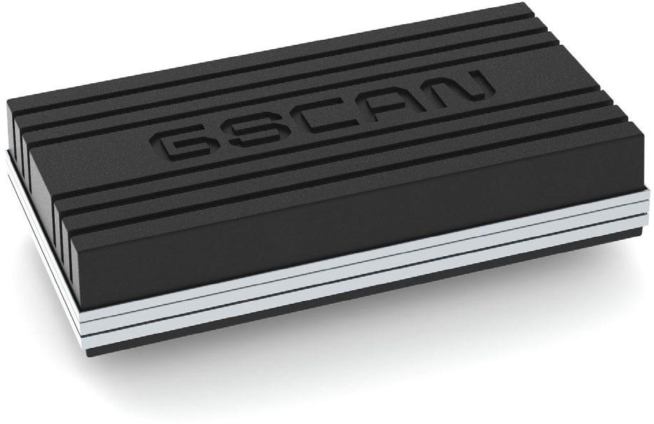

GSCAN OÜ www.gscan.eu
CONTACT
Andi Hektor andi.hektor@gscan.eu +37256150288
GScan is pioneering the field of muon tomography. We are developing and manufacturing modular Muon Flux Technology (MFT) µFLUX scanners - capable of 3D imaging and performing chemical composition analysis even through the toughest of shielding. GScan’s MFT modules are 1.7m x 1m in size, allowing the technology to be highly flexible and suitable for any imaging requirements. Paired with the hardware, GScan has developed an analytics toolkit (including patented topographical algorithms), allowing the technology to be used in either tomographic or radiographic configurations. The modules are tracking the passing particles with 100 micrometre spatial and 1 milliradian angular resolution - allowing to reach 99%+ material classification accuracy at 1 millimetre 3D imaging resolution. The technology has found vast use in non-destructive testing, infrastructure scanning, security and more. Use cases include, but are not limited to:
• 3D mapping a nuclear test reactor and waste
• Analysing Estonia’s bridges with GScan's Muon Flux Technology (MFT
• MFT based 3D scanner system for evaluating the technical condition of reinforced concrete and steel structures
• Developing a large-scale MFT based scanner system for 20ft sea containers and other objects of suitable volume
• Studying the feasibility of MFT applications in Lunar and Martian Environments
GScan has developed and perfected the technology since 2018, releasing their first customerready product, the µFLUX Infra module, in early 2023. Over the years, GScan has had the honour of expanding their network of partners throughout the world, including technical, academic and strategic partners - ensuring that the technology gains traction in a vast variety of fields. GScan is currently active in non-destructive testing, security, infrastructure scanning, defence & dual-use, as well as sector agnostic. Furthermore, feasibility studies into the technology’s applications in medicine have already started, providing highly positive initial results.
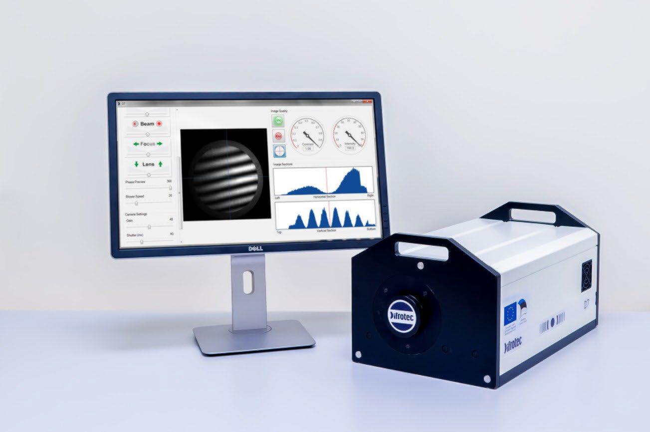
High accuracy interferometer for testing shape and wave front quality of optical elements and systems. The interferometer D7 is proven for x-ray and semiconductor applications. Expansion is planned to space and other industries.
DIFROTEC difrotec.com
CONTACT
Mariia Voznesenskaia maria@difrotec.com +372 5901 6617
Traditional interferometers existing on the market use a special certified optical element as a reference for testing other optical elements.
Due to the growing complexity of forms and shapes of optical elements (e.g., aspheres and free-form mirrors for space telescopes) physical optical references became insufficient to achieve high level of accuracy.
To overcome this limit optics manufacturers use several metrology tools combining and averaging the results. Therefore, high accuracy measurements became time and cost intensive process.
Difrotec has developed the next generation interferometer D7 for testing any type of optics with accuracy 10-20 times exceeding competitive interferometers. Instead of using an interferometer and at least 3 or even 4 accessories like Zygo, Mahr-ESDI or QED do, Difrotec technology requires an interferometer and only 1 or 2 universal accessories which cover wide range of optical shapes. Previously Difrotec worked with US and Chinese customers who makes optics for x-ray and semiconductor applications. Now we move to test D7 for space and other not-optics related industries (e.g. automotive).
The D7 technology has patented in US (10247539) and Europe (EP318782). In addition to hardware Difrotec has developed analytical software for processing measurement results and moving from hardware sales to services and software. For this we need to expand our production capabilities and complete software development.

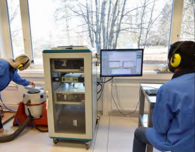
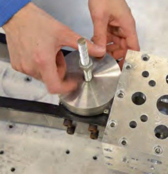
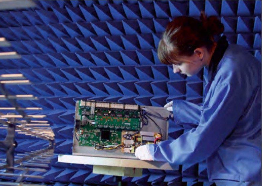
The space technology laboratories of Tartu Observatory are part of the Testing Centre of the University of Tartu. The quality management system of the Testing Centre fulfills the requirements of ISO 17025:2017 standard.
UNIVERSITY OF TARTU, TARTU OBSERVATORY, SPACE TECHNOLOGY
Riho Vendt, PhD
Mihkel Pajusalu, PhD Head of Space Technology Department at Tartu Observatory, University of Tartu mihkel.pajusalu@ut.ee +372 5381 5711
The laboratory complex of Tartu Observatory in Tõravere, Estonia offers laboratory services for development and testing of space technology, environmental testing and optical measurements.
The laboratories include special electrostatic discharge (ESD) safe areas, cleanroom (Class 8, ISO 14644-and anechoic environment. All laboratories include automatic control for ambient temperature and humidity conditions.
The space technology laboratories of Tartu Observatory are part of the Testing Centre of the University of Tartu. The quality management system of the Testing Centre fulfils the requirements of ISO 17025:2017 standard. The Testing Centre was firstly accepted as accredited testing laboratory in 2003 and calibration laboratory in 2008 by Estonian Accreditation Centre.
The Tartu Observatory’s laboratories are also a part of ADAPTER, the network of Estonian universities, research and development organizations.
Further details can be found at: kosmos.ut.ee/en/services/laboratory-services.
Brochure detailing technical parameters of all Tartu Observatory testing facilities can be found at: kosmos.ut.ee/sites/default/files/kosmos/toravere-laborid-eng-30-05-2019-netti.pdf
INTELLECTUAL PROPERTY
IP belongs to University of Tartu.
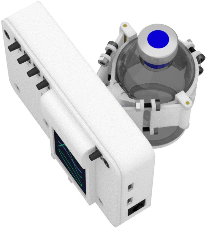
The sensor system allows to precisely measure molecular oxygen concentration in environments with concentrations of 0-100ppm with below 0.5 ppm detection limit. Similar sensors with different configurations can be used to measure in environments with higher concentrations of O2. Main target is astrobiology, geobiology and other fields requiring oxygen free environment.
DETAILS
UNIVERSITY OF TARTU, TARTU OBSERVATORY, SPACE TECHNOLOGY
Mihkel Pajusalu, PhD
CONTACT
Mihkel Pajusalu, PhD Head of Space Technology Department at Tartu Observatory, University of Tartu mihkel.pajusalu@ut.ee +372 5381 5711
Optoelectronic oxygen sensors based on luminescence lifetime for measuring oxygen concentration from sub microbar to present atmospheric levels and above (depending on configuration).
The technology was originally developed at the Massachusetts Institute of Technology (MIT) for astrobiology and geobiology purposes (by Dr. Mihkel Pajusalu). The technology was licensed as open source and currently we are looking into commercial manufacturing in Estonia.
The technology is based on using a modulated light source to excite dye and measure its luminescence lifetime, which correlates with the amount of oxygen present. The main use of this is simulation experiments on ground for testing astrobiologically relevant scenarios and for verifying oxygen-free environments on ground. Technology could be modified for space use.
Publications:
+ doi.org/10.1371/journal.pone.0206678 (detailed description)
+ www.nature.com/articles/s41550-020-1069-4
+ www.nature.com/articles/s41586-019-1804-0 (application in experiments)
INTELLECTUAL PROPERTY
IP has been released into Open Source under BSD and CC BY licenses.

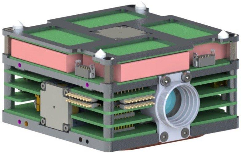
This integrated satellite bus with high volumetric efficiency has been developed with a plan to enable future interplanetary missions with Cubesat form-factor spacecraft. The 0.6U bus module will fly on the ESTCube-2 mission and will be the basis for the future ESTCube-3 Lunar mission
UNIVERSITY OF TARTU, TARTU OBSERVATORY, SPACE TECHNOLOGY
Kristo Allaje
CONTACT
Mihkel Pajusalu, PhD Head of Space Technology Department at Tartu Observatory, University of Tartu mihkel.pajusalu@ut.ee +372 5381 5711
DETAILS
The integrated satellite bus with high volumetric efficiency was developed for the ESTCube-2 mission, which aims to demonstrate the capability to conduct operations away from Low-Earth orbit and magnetosphere. Therefore, the bus includes a full suite of attitude determination sensor suite including a Star Tracker mini camera unit and an integrated set of three reaction wheels.
In addition, the bus comprises all mission critical subsystems, the on-board computer, electrical power systems and batteries, communications system and the FPGA-based Star Tracker electronics. Most of the bus electronics also fit into a 0.3U CubeSat unit size stack, on top of which the scalable battery layer can be placed.
The development is partly based on the ESTCube-1 bus, which operated successfully in space for over two years (2013-2015) and is TRL9. Its heritage has partially been commercialized by CrystalSpace OÜ.
KEY INFORMATION
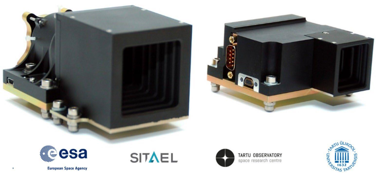
Technologies and know-how for development of miniature cameras for customer defined space mission configurations.
UNIVERSITY OF TARTU, TARTU OBSERVATORY , SPACE TECHNOLOGY
Hendrik Ehrpais, MSc
CONTACT
Mihkel Pajusalu, PhD Head of Space Technology Department at Tartu Observatory, University of Tartu mihkel.pajusalu@ut.ee +372 5381 5711
Space imaging hardware previously developed by Tartu Observatory have included cameras for European Student Earth Orbiter, ESTCube-1 and ESTCube-2 (three cameras on orbit and two being prepared for launch).
Currently, cameras for use on Lunar rovers and Optical Periscopic Imager for Comets for ESA F-class mission Comet Interceptor (ESA Contract No. 4000131003/20/NL/IB/ig are being developed. Lunar rover camera development is together with CrystalSpace/Krakul.
We have background in all aspects of optics testing, qualification for space environment, sensors, readout electronics, and the facilities to perform such tests in the form of Tartu Observatory’s Space Technology Labs. We can design custom cameras per ESA/NASA mission requirements both based on reflective and refractive optics.
INTELLECTUAL PROPERTY
IP regarding to the overall design of the camera. Ways are being studied to commercialize this.
KEY INFORMATION
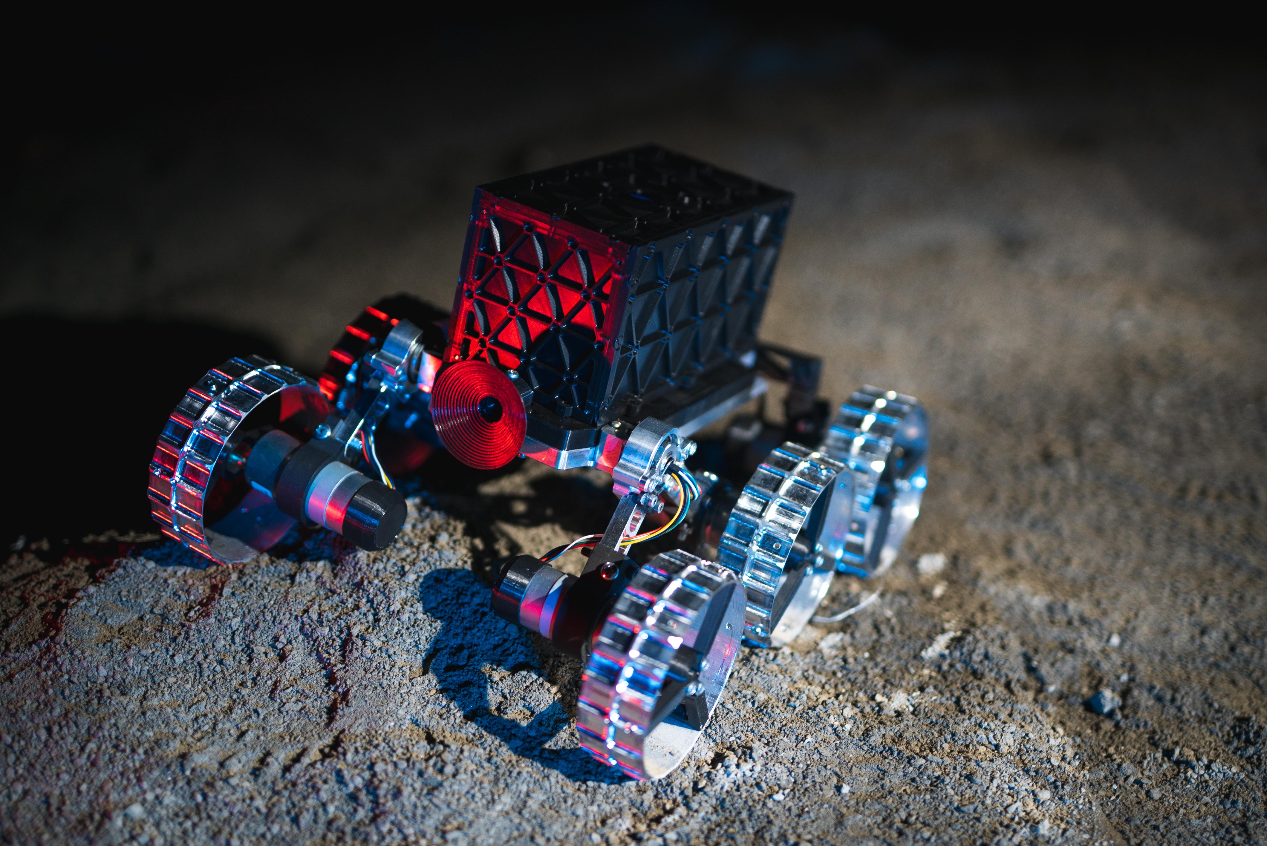
In-house development of miniature Lunar rovers.
UNIVERSITY OF TARTU, TARTU OBSERVATORY
CONTACT
Mihkel Pajusalu, PhD Head of Space Technology Department at Tartu Observatory, University of Tartu mihkel.pajusalu@ut.ee +372 5381 5711
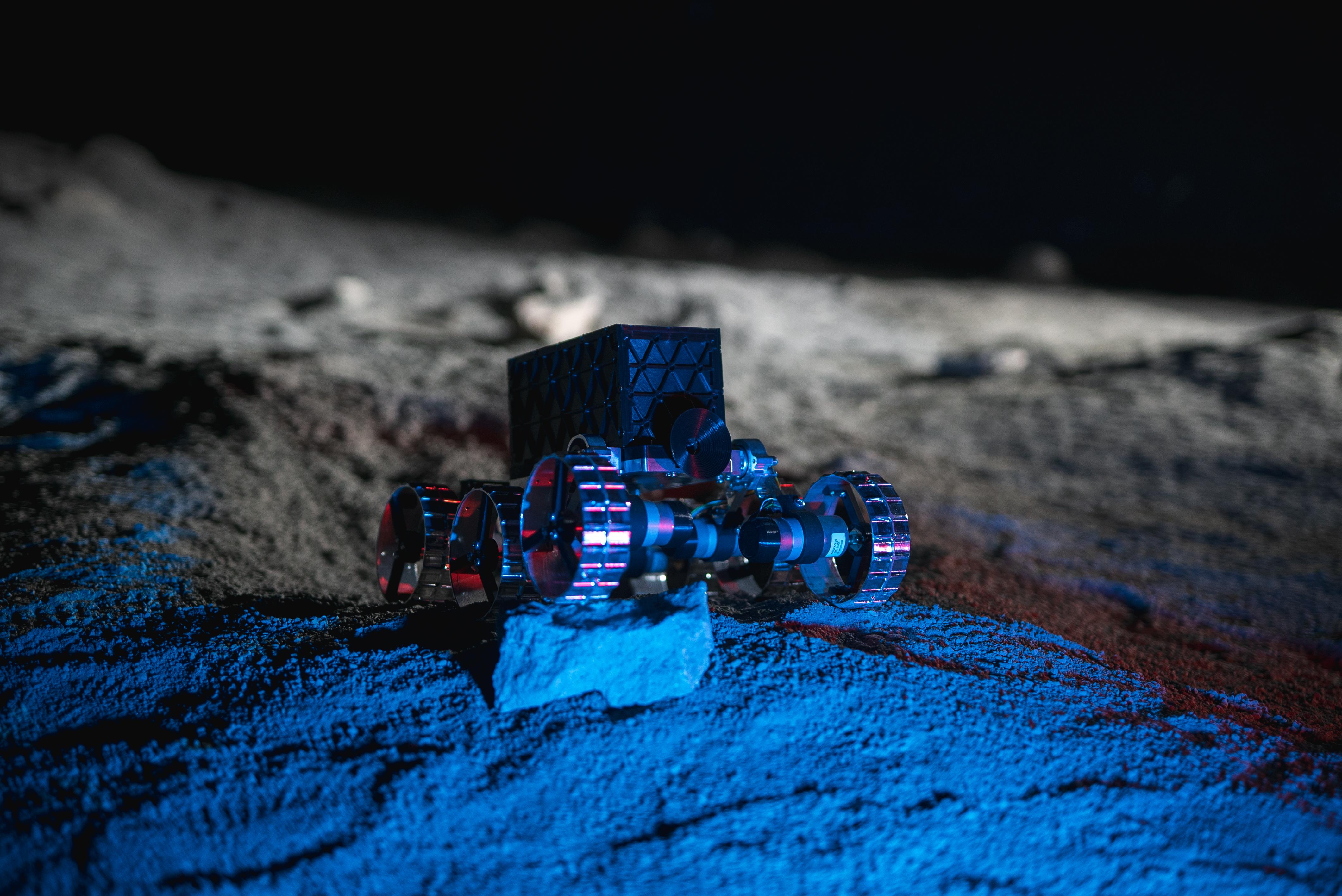
KuupKulgur is a small and flexible Lunar Rover with an aim to facilitate Estonian technology demonstration on the Lunar surface. It is a student-led cube-rover program with the goal of delivering the first Estonian Lunar rover to the Moon. The current rover being designed acts as a mobility service provider while also offering the payload with power, communcation, and teleoperations, allowing on-board cube-sat compatible payload flight heritage in a Lunar context.
The team makes use of various facilities, including the ULYSSES simulation environment and the Lunar analogue facilities at Tartu Observatory, within the rover's design process. This program offers a distinctive chance to explore and research the potential for robotic autonomy on platforms with limited resources in extraterrestrial environments. Currently in its feasibility study phase, the team is diligently defining mission parameters, capabilities, constraints, and identifying potential payloads.
KEY INFORMATION
The space technology laboratories of Tartu Observatory are part of the Testing Centre of the University of Tartu. The quality management system of the Testing Centre fulfils the requirements of ISO 17025:2017 standard.
DETAILS
The laboratory complex of Tartu Observatory in Tõravere, Estonia offers laboratory services for development and testing of space technology, environmental testing and optical measurements.
UNIVERSITY OF TARTU, TARTU OBSERVATORY, SPACE TECHNOLOGY
Riho Vendt, PhD
CONTACT
Mihkel Pajusalu, PhD Head of Space Technology Department at Tartu Observatory, University of Tartu mihkel.pajusalu@ut.ee +372 5381 5711
The laboratories include special electrostatic discharge (ESD) safe areas, cleanroom (Class 8, ISO 14644-and anechoic environment. All laboratories include automatic control for ambient temperature and humidity conditions.
The space technology laboratories of Tartu Observatory are part of the Testing Centre of the University of Tartu. The quality management system of the Testing Centre fulfils the requirements of ISO 17025:2017 standard. The Testing Centre was firstly accepted as accredited testing laboratory in 2003 and calibration laboratory in 2008 by Estonian Accreditation Centre.
The Tartu Observatory’s laboratories are also a part of ADAPTER, the network of Estonian universities, research and development organizations.
Further details can be found at: kosmos.ut.ee/en/services/laboratory-services. Brochure detailing technical parameters of all Tartu Observatory testing facilities can be found at: kosmos.ut.ee/sites/default/files/kosmos/toravere-laborid-eng-30-05-2019-netti.pdf
INTELLECTUAL PROPERTY
IP belongs to Tartu University.
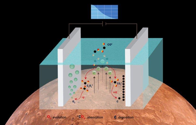
The Energy Technologies Laboratory is developing a technology to split CO2 into solid carbon and gaseous oxygen in molten salts to obtain breathable oxygen on Mars.
DETAILS

NATIONAL INSTITUTE OF CHEMICAL PHYSICS AND BIOPHYSICS
Ivar Kruusenberg, PhD
CONTACT
Ivar Kruusenberg, PhD ivar.kruusenberg@kbfi.ee
The atmosphere of Mars consists (by volume) over 95% of oxygen and carbon, elements that are crucial for human life. However, most of it is stuck in CO2, which is a very stable molecule and difficult to break.
Molten salt carbon capture and electrochemical transformation (MSCC-ET) is a technology where the CO2 molecule is broken up into solid carbon and molecular oxygen via a carbonate salt electrolyte. On earth, this technology has been touted to be the solution to the rising CO2 levels in the atmosphere. On Mars, it could be a solution to two problems: energy storage and oxygen production.
The carbon created on the cathode of the CO2 electrolyser could be burnt or re-oxidized afterwards in direct carbon fuel cell. In the literature, the charge efficiency of the deposition-oxidation of the carbon has been found to be up to 95%. On earth the deposition rate is limited by the low partial pressure of CO2, which is not a problem on Mars. On the anode side, one molecule of oxygen is created for each carbon atom added to the cathode product, which could be used to regenerate artificial air. A similar process is already in use by ESA to generate oxygen from moon regolith and in NASA’s MOXIE. A reactor technology is being developed, where solar power is used to drive the electrochemical splitting of CO2 into solid carbon and gaseous oxygen, which are then separated and stored. The issues that need to be solved are:
1) What is the efficiency of solid carbon storage and re-oxidation in Mars atmosphere under a voltage conceivably producible with solar panels,
2) What is the purity of the gaseous oxygen products in such a reactor, whether or not it can be used to regenerate artificial air and
3) If the relatively high temperatures needed for melting the electrolytes are achievable in a small reactor in Mars conditions.
MSCC-ET technology has the potential to provide oxygen for the regeneration of artificial air as well as a method for energy storage for space missions. Thus far a lot of the focus in the development of this technology has been on cheaply producing carbon nanomaterials, but other uses such as oxygen production and energy storage as carbon have been overlooked. The Energy Technologies Laboratory aims to study this process in a variety of atmospheres replicating conditions of space missions and to reduce the working temperature while increasing the energy efficiency.


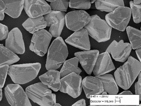
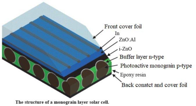
Monograin layer solar cell technology is one of the promising technologies for in-situ resource utilization in space. It will allow us to manufacture solar cells from Lunar - or Mars regolith.


TALLINN UNIVERSITY OF TECHNOLOGY, SCHOOL OF ENGINEERING, DEPARTMENT OF MATERIAL AND ENVIRONMENTAL TECHNOLOGY, LABORATORY OF PV MATERIALS, LABORATORY OF OPTOELECTRONIC MATERIALS
Taavi Raadik, PhD
CONTACT
Taavi Raadik, PhD taavi.raadik@taltech.ee +372 5649 1983
The monograin layer solar cell (MGL) has a superstrata structure: Back foil/graphite/absorber/buffer/ZnO/ glass (or polymer film), where the absorber is a monolayer of nearly unisize, with a typical diameter of 40 µm, semiconductor powder crystals embedded into a layer of epoxy without contaminating the upper surfaces. CdS buffer layer is deposited onto the monograins by chemical bath deposition. The intrinsic ZnO and Al doped ZnO are deposited by RF sputtering. Solar cell structure is completed by vacuum evaporation of In grid contacts onto the ZnO window layer. Graphite paste is used to make the back contact.
The advantages of MGL solar cell technology are the following: (1) the absorber material monograins with single crystal`s optoelectronic properties could be obtained, (2) it is possible to achieve uniform distribution of elements due to high synthesis temperatures in the molten phase of flux where the material diffusion and transport processes are fast and therefore unwanted secondary phases can be avoided, (3) the material and the solar cell are prepared separately, enabling to perform post treatments only to the monograins, (4)the area and shape of the MGL solar modules with uniform properties is not limited, and (5) flexible cheap substrates can be used enabling versatile applications. Additionally, various semiconductors having photosensitivity could be used as an absorber in the MGL solar cell. Currently, MGL technology has proven to work well with semiconductors such as CuInSe2, CuInS2 , Cu2ZnSnS4 , Cu2ZnSnSe2 and their solid solutions Cu2ZnSn(SxSe1-x)4, also Cu(In,Ga)Se2, and CdTe. With ketserite materials Cu2ZnSnS4 and Cu2ZnSn(SxSe1-x)4, device performance close to the World record efficiencies in the field, are obtained.
Due to the advantages of MGL solar cell technology TalTech has been collaborating with ESA. ESA has shown remarkable interest to the technology for in-situ resource utilization in order to manufacture MGL solar cells from resources available on moon or other celestial body.
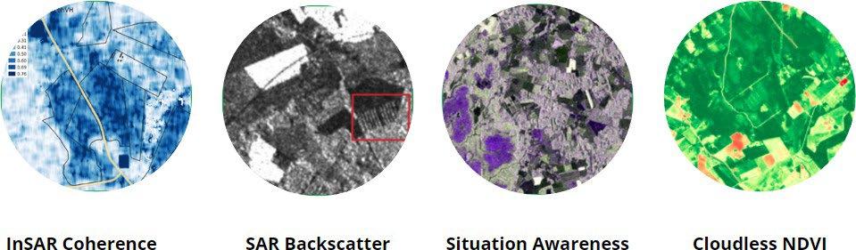
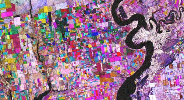
We deliver both Sentinel-1 calibrated and noise corrected coherence and backscatter time-series as statistics for parcels (areas of interest) and as raster images for clients who need data for further raster-based analyses or visual interpretation.al interpretation.

KAPPAZETA kappazeta.ee
CONTACT
Jürgen Lina Business Development Manager jurgen.lina@kappazeta.ee
Kappazeta has developed an automated processing chain for Sentinel-1 satellite images to produce a time series for several parcel-related parameters. The calculated time series can be shared in various formats: e.g., database dump, .csv, through API, or through a custom requested format.
Which parameters and statistics can we calculate?
All parameters can be calculated over the area of a clients interest. We can provide:
- Coh VH, Coh VV - 6-day repeat pass interferometric coherence in VH and VV polarization
- VH/VV ratio - VH and VV polarization back-scatter ratio
- s0VH, s0VV - Calibrated and noise corrected back-scatter (sigma0) in VH and VV polarization
- Why our Sentinel-1 time series are the best on the market?
- Covering smaller parcels – we can reliably process 35 to 50% more parcels than other services on the market. Depending on the parcel shape we can go down to 0.5 ha parcels.
- Handling the noise correction professionally – compared to the output of common processing software, e.g., ESA SNAP, the parameters are less biased resulting in more accurate and reliable models.
- Solid performance for operational services – in 2017 we enabled the first country-wide mowing detection system (Estonia) and have kept it operational since then.
Where are time series from satellite data already used?
Sentinel-1 time series can improve models which are solely based on optical data. We have been using S1 data in machine learning models for agricultural insurance companies, including for crop yield prediction, damaged area delineation and field risk assessment. For carbon farming and afforestation projects we can create models to detect tree presence, crop type/rotation, cover crop and tillage events. Our time series together with machine learning algorithms are also used in nationwide systems for automated inspection of farmlands in Estonia and elsewhere for CAP monitoring and AMS systems. Check out our demo map: https://map.kappaone.eu/ard_demo/.
KEY INFORMATION
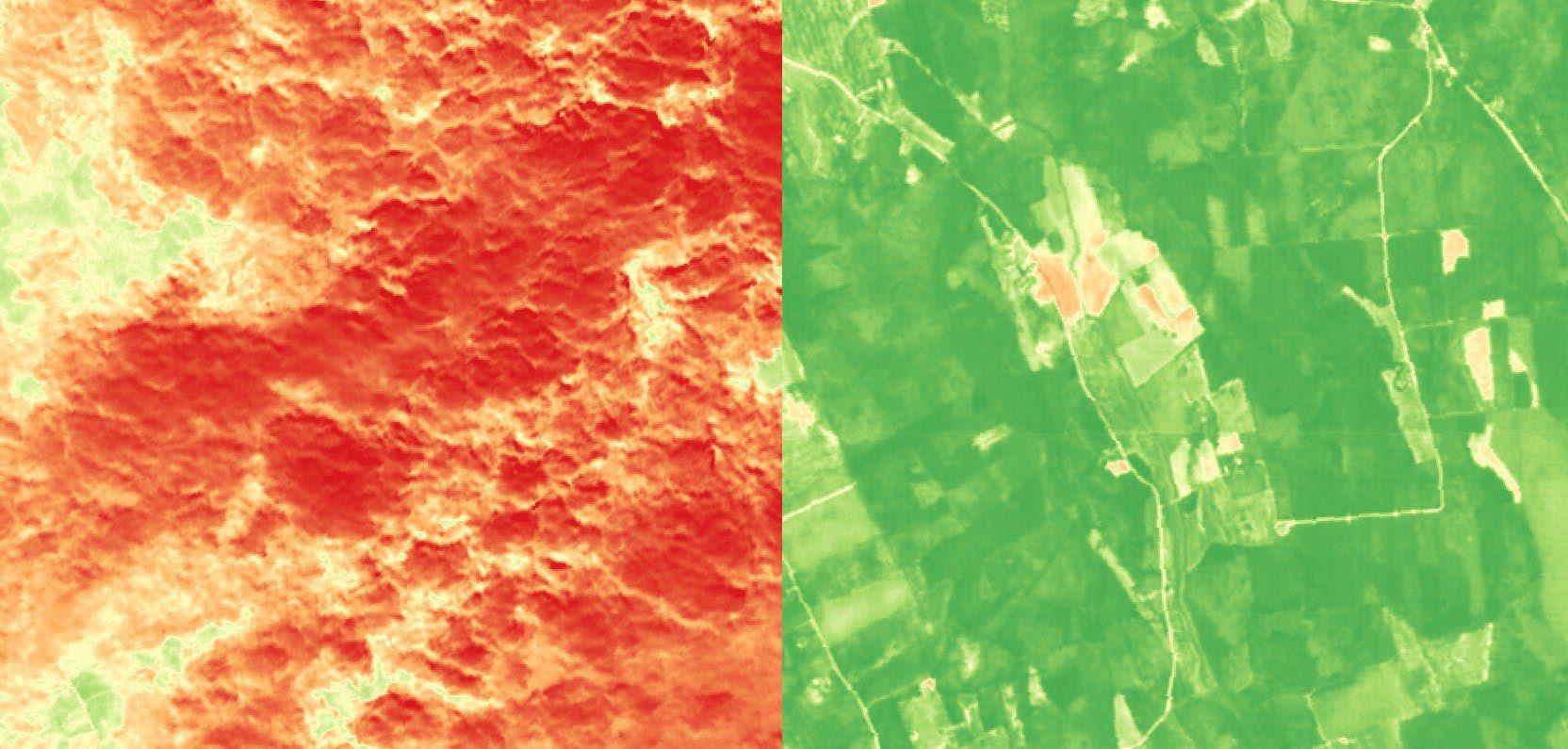
We can remove cloud cover and other atmospheric interferences that often obscure optical satellite imagery, making it possible to monitor the health and productivity of vegetation more frequently.
KAPPAZETA kappazeta.ee
CONTACT
Jürgen Lina
Business Development Manager jurgen.lina@kappazeta.ee
DETAILS
Cloud can obscure optical satellite imagery, making consistent vegetation monitoring difficult. Depending on the area and season the gaps in time series can be longer than a month. This hinders downstream applications, such as detecting crop damage, yield map synthesis, and others that rely on a sufficiently dense series of NDVI images Cloud cover is especially problematic in the autumn, where cover persists for long periods
Thanks to our KappaMask cloudmask, we can accurately filter out cloud-covered areas in optical satellite imagery and refill the gaps wih AI-modeled NDVI using weather independent data radar satellite data.The backscatter of Synthetic Aperture Radar (SAR) data are useful for detecting crop cover over agricultural areas whilst the coherence could be inversely correlated to NDVI, making them complementary for interpolating missing NDVI data.
Cloduless sNDVI could be used as regular weather independent data product on its ownconstantly reflecting the status of the vegetation of an area of interest, it could also be as an input parameter for higher level agricultural services including for crop yield prediction, damaged area delineation and field risk assessment. Another useful application for agricultural paying agencies and/or farmers may be zoning or detecting fields and subfields which demonstrate homogenous or heterogenous growth.
It takes 10 years on average to build a high-voltage overhead line. The build-out of solar and wind is faster than our ability to build the grid. Insufficient transmission is now one of the biggest obstacles to cheap and clean energy.
Grid Raven helps use our existing grid assets to their maximum potential. Transmission overhead lines are extremely sensitive to wind: already a 2 m/s wind cools the conductors so effectively that twice the amount of energy can safely be transmitted. By properly accounting with the wind, it is possible to transmit on average 30% more power through the grid, globally.

gridraven.com
CONTACT
Georg Rute CEO of Grid Raven georg@gridraven.com
Gridraven's core innovation is an AI-based hyper-local weather prediction, which accounts with the effect of every tree, building and hill near each power line. The resulting weather and wind forecast has meterscale accuracy.
The hyper-local weather prediction is then used in Gridraven Claw, our service for determining the maximum transmission capacity of every power line in the world.
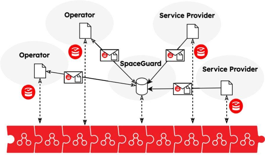
SpaceGuard is a software solution that monitors satellite traffic coordination processes in a space traffic coordination network, identifies problems and issues in the communication between operators in the said network. The goal of SpaceGuard is to be a coherent and efficient monitoring platform that not only provides both general and specific overviews of the real-time and historic coordination events, but also a potent possibility for safeguarding the data and communication between different parties, connected to a coordination platform.
GUARDTIME guardtime.com
CONTACT
Kaarel Hanson Space Program Manager kaarel.hanson@guardtime.com
SpaceGuard is a decentralised system for monitoring and managing space traffic coordination systems exchanging collision avoidance data between the involved entities in a secure and trusted way. These entities include operators, catalogue and conjunction data providers as well as service and/or supporting entities, such as expert centres. Such data exchange needs to comply with needs of the various actor roles, e.g. in terms of limiting data visibility to restricted collection of other entities, as well as ensure that data is unaltered during the communication process, and sending and the reception of messages is logged in a verifiable way. The communication between different parties is monitored, analysed and safeguarded for long-term verification.
Each message sent or received by an involved entity is cryptographically safeguarded using KSI, a blockchain-based time-stamping service designed and operated by Guardtime. This functionality is useful in resolving or even preventing some disputes between parties. Having cryptographic proof that data was sent and received by the intended recipient eliminates false claims that some data was not available or it was not presented in a timely manner. Safeguarding the communication channel is essential against false claims of unavailable connectivity. One party can not claim it was impossible to fulfil its obligations or respond to events due to unavailable communication.
Finally, SpaceGuard provides regulators a global situational awareness in the coordination domain by visualising all the data that has been collected, incuding active and historical events. This is a useful tool for conformity and compliance monitoring of space traffic coordination regulations.
KEY INFORMATION
Fundamental digital integrity platform for Earth Observation Data products, providing immutable proof of integrity and provenance for all satellite data residing on long term archives.
GUARDTIME guardtime.com
CONTACT
Kaarel Hanson Space Program Manager kaarel.hanson@guardtime.com
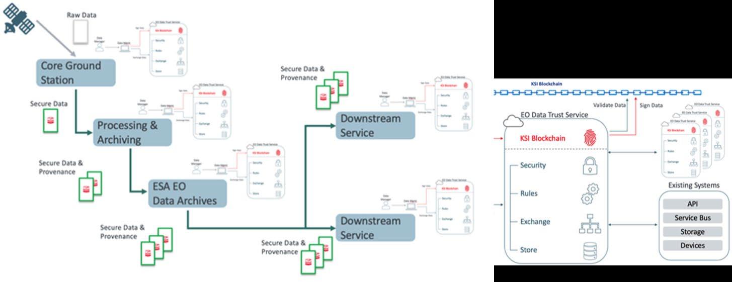
The technical objectives are:
+ ensured integrity, auditability and quality control for the long term archives that are the main source of data for a data access front-end system;
+ enhanced EO Data Quality Assurance framework with new capabilities to manage, control and distribute data;
+ enabled identical capability for long term archives. Available also for the Data and Information Access Services (DIAS) and National datahubs.
The focus of the technology is:
+ securing long-term data archives, to ensure and facilitate the accessibility and usability of the preserved data sets;
+ reducing the storage capacity of EO products by applying the on-demand product processing;
+ provision of the proof and evidence of time, provenance chain and processes used for development of EO downstream services.
Challenges to be tackled: EO Data archives and supply chain immutability, situational awareness, composition and dissemination.
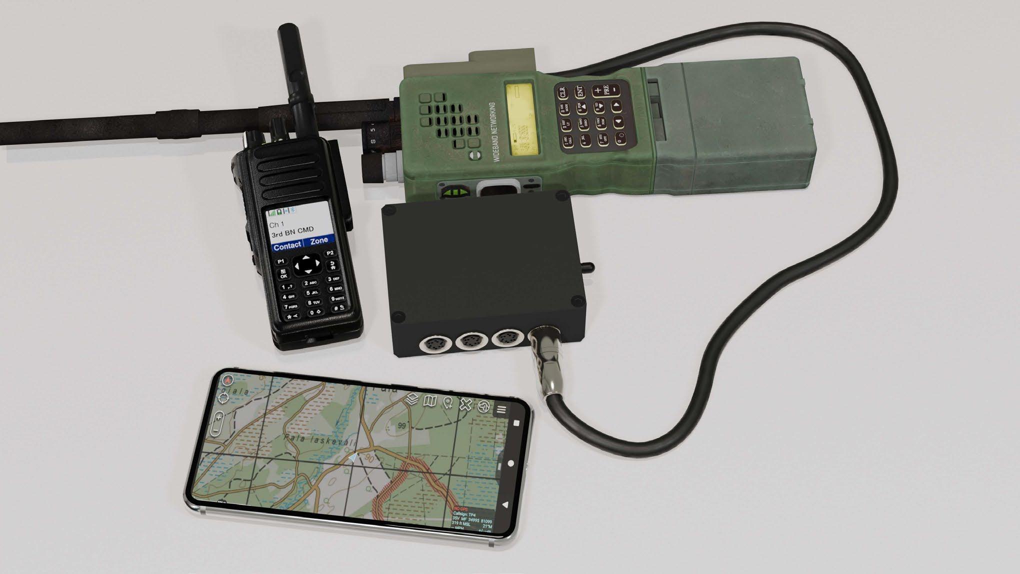
Wayren ensures uninterrupted communication in demanding environments such as battlefields, underground, space, and remote areas. It operates without central management and remains functional even when primary infrastructure fails. It can be deployed on smart devices, sensors, and vehicles, securely connecting everything.
DETAILS
Standard TCP/IP struggles with packet loss rates over 35%, which is inadequate for demanding environments with average losses of 70% due to rough terrain and jamming. Wayren's patent-pending data synchronization protocol manages packet loss of over 85%, making digitalization feasible in extreme conditions. The platform supports various devices and network technologies.
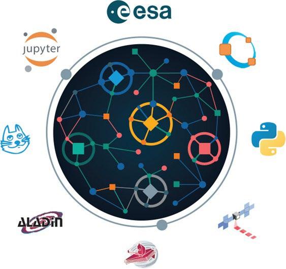
ESA Datalabs is a virtual research environment being developed in collaboration between AS CGI Eesti and ESA, that provides access to a range of satellite data, processing tools, and resources to support research and innovation. The platform is designed to enable users to explore, analyze, and visualize data from ESA's science missions, as well as other sources, using state-of-the-art processing tools and algorithms.
AS CGI EESTI www.cgi.com/ee/et
CONTACT
Sille Kraam sille.kraam@cgi.com
ESA datalabs offers a catalog of data manipulation and visualization toolsets (called Datalabs) made available for users. They range from new tools that have quickly become de facto standards to older software that has been repackaged to run inside virtual computers. The environment can be accessible via web browser.
Typical users of ESA Datalabs are scientific teams from ESA, the academia and industry looking to exploit the data made available by ESA. The users can develop notebooks in JupyterLab and pick their programming language from a large and expanding set of languages. The system has implemented customized JupyterLab to be immediately useful, with no further work, for astronomers, scientists in Earth Observation related field, or researchers in the navigation area.
ESA datalabs offers the possibility to search ESA’s data collections across domains using the ESA data discovery portal. A data collection is, in general, any set of digital assets, but the best example is an official data release from an ESA mission. Once you find a collection, ESA datalabs offers users the possibility of adding that collection to their workspace; no data transfer will be done and the collection will appear as just another folder.
The CGI Estonia Space & Earth Observation (EO) team has developed an open-source toolset for very fast generation of optical and radar EO data products.
Sille Kraam sille.kraam@cgi.com
The toolbox consists of software tools for very fast EO data processing on Graphical Processing Units (GPU-s). The tools are designed to work in processing infrastructures where both EO data and GPU-s have been made accessible for the software, and implement pre-processing routines for commonly used Optical and Synthetic Aperture Radar (SAR) EO data, allowing users more timely and convenient access to analysis-ready data without having to do manual pre-processing, that is conventionally a time -consuming activity. The use of GPU technology reduces the time, energy and costs spent on processing EO data by around an order of magnitude, smoothening user experience when doing on-demand processing and unlocking new application concepts that require fast generation of EO information.
The ALUs toolbox is in constant evolution, and new processing algorithms are added to the functionality. The latest version can be found on GitHub: https://github.com/cgiestonia-space/ALUs

MindChip OÜ, an Estonian deep-tech company, develops autonomous robotic vessels and AI-based maritime solutions. ASVs, like the MC2500 and MC600, are modular and versatile, capable of performing various tasks from environmental monitoring, all with minimal human intervention.
MindChip OÜ www.mindchip.ee
CONTACT
Heigo Mõlder, PhD
CEO of MindChip OÜ
Phone: +372 5264992
e-mail: heigo@mindchip.ee
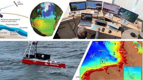
Our mission is to modernize the automated surveying of maritime areas. For instance, in Estonia, 30% of maritime areas lack up-to-date data, compromising safety and seabed knowledge.
By leveraging Satellite-Derived Bathymetry (SDB) in conjunction with our autonomous robotic vessel, we will efficiently validate and extend SDB data, enabling precise and rapid coverage of vast areas. Supported by research from Estonian Maritime Academy at the University of Tartu, this initiative specifically targets the high demand for accurate surveys, particularly in rocky and shallow coastal regions.
Additionally, we are developing a web platform to facilitate self-service measurement orders.
KEY INFORMATION
The early warning system Sille.Space uses data from the European Union's satellites and can detect the shifts and subsidence of infrastructure such as bridges, power plants, dams, port areas, mines and large buildings with a precision of up to 2 mm.

DATEL AS www.datel.eu www.sille.space
CONTACT
Oliver Stimmer oliver.stimmer@datel.ee +372 5309 9830
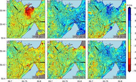
DETAILS
Sille.Space is based on InSAR analyses. InSar is powerful remote sensing method that allow measure mm scale movements in well reflecting (coherent) surfaces. The measurements base interferometric phase analyze that has widely known other Physical disciplines. The Space based InSar analyses relay Satellite SAR (Synthetic Aperture Radar) phase images. The Satellite revisit area over a period of time. Stack those phase images timely then it’s possible to get information of movements in client interested area.
Levelling-benchmarks case study
Tallinn city -planning office has successfully used Sille.Space to analyse its network of height benchmarks. This has enabled the Geodesy and Land Management Unit to make well-informed decisions about which parts of the height benchmarks need re-levelling, avoiding unnecessary and large-scale engineering tasks and saving hundreds of thousands of euros in costs.
Company profile
Through delivering multiple e-government systems, AS Datel has enabled the transformation of traditionally analog and manual services to digital and efficient systems across continents. Our core competences are: Address Management, Land Management, Cadastre systems, ePlanning (Road administration and e-construction systems, 3D Twins, Earth observation (Big Data analysis and modelling), Permitting systems (building, transport, and water).
KEY INFORMATION
Solution idea: construction activities detected from the satellite data are compared with building permits and activities not covered by permits are highlighted for to the local government.
DATEL AS www.datel.eu www.sille.space
CONTACT
Oliver Stimmer oliver.stimmer@datel.ee +372 5309 9830
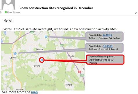
Figure. Notification e-mail about the construction activity in the selected area
The general approach will be based on detecting change in the SAR amplitude images over a given time period. Datel AS has already established a robust data infrastructure, which includes complex tooling and pipelines designed to facilitate rapid access to Sentinel 1 SAR data. This infrastructure was initially developed for the SILLE https://sille.space/en/ SAR interferometry application.
Company profile
Through delivering multiple e-government systems, AS Datel has enabled the transformation of traditionally analog and manual services to digital and efficient systems across continents. Our core competences are: Address Management, Land Management, Cadastre systems, ePlanning (Road administration and e-construction systems, 3D Twins, Earth observation (Big Data analysis and modelling), Permitting systems (building, transport, and water).
Rexplorer is combining open-source registries with earth observation data to scale buildings rooftop solar energy simulations. By using 3D modelling the software automatically calculates power production by solar panel accuracy for any building and visualize it on a digital twin.

REXPLORER
rexplorer.ee
CONTACT
Hendrik Hundt
Chief Operating Officer hendrik.hundt@rexplorer.ee +372 5665 6464
Rexplorer algorithm calculates how many solar panels can fit on any size, angle and shape of buildings rooftop. It also calculates the estimated energy production, installation cost, and investment pay off period and models it out over a 25 year simulation time period. Our technological solution is built on 3D models point coordinates of the building and calculate usable surfaces, slopes, azimuth, area, suitability, solar panel dimensions, power output and combine with hourly solar irradiation data throughout the year.
With incorporating AI machine learning models to detect roofs, extract shapes, chimneys, and other obstacles on roofs. By developing and training our neural network the technology PoC is globally scalable with space and aerial images of Estonia, Poland, Germany, and Spain.
Rexplorer OÜ is a Tallinn, Estonia based greentech start-up founded in 2020. The company was established to develop renewable energy analytics software and to enable Europe’s rapid transition to sustainable energy solutions. In the two years of activity Rexplorer has projected thousands of PV installations and combined hundreds of different datasets for renewable energy planning purposes. The software utilizing earth observation data is LIVE and accessible from https://app.rexplorer.ee/explore. The software architecture is built so it is ready to be scaled up to other European countries in the upcoming year. The app allows end-users to automatically model their rooftop solar installation from scratch, only by entering an address. The application is free of charge to users and our business model includes solar installer partnerships and selling the software as a service.
Developing advanced human-robot collaboration that simultaneously leverages AI-driven control automation and human-centered information automation while advocating high system modularity for agile integration of the latest results in research and technology.
UNIVERSITY OF TARTU, INSTITUTE OF TECHNOLOGY
Karl Kruusamäe
Karl Kruusamäe, PhD
Associate Professor of Robotics Engineering
karl.kruusamae@ut.ee
+372 5886 3299
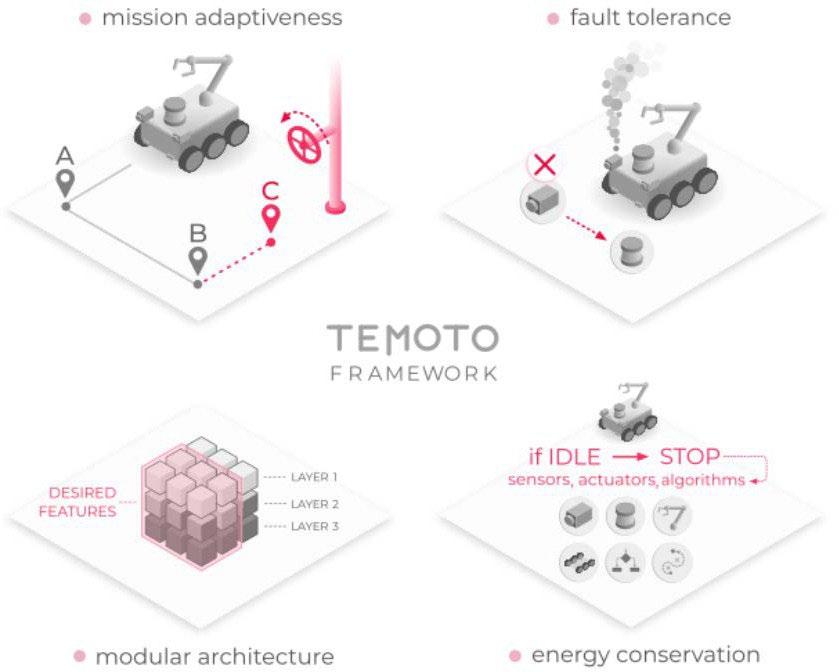
The role of operator interfaces is to empower a human to solve a task with the help of a remote or co-located robot. We focus on developing and validating intuitive telerobotics operator interfaces for minimizing cognitive load to ensure fault tolerant and long-term autonomy. Intuitive telerobotic user experiences take advantage of all available communication modalities (e.g., speech, gestures and touch) as well as cultural and psychological profile of the intended user. To that end, we cover the full range of human-robot collaboration from human effortlessly controlling a robotic device to human assisting a highly-autonomous robotic agent. We are actively developing TeMoto, a software framework for adaptive and dependable robotic autonomy with dynamic resource management.
Our main areas of work include:
1) software framework for adaptive and dependable robotic autonomy for human-robot collaboration in high risk, high environment complexity and high level of autonomy.
2) designing human-robot interaction that leverages variable levels of autonomy, AI-driven motion planning, and augmented reality.
3) robot hardware and software platforms validating research results, showcasing technology readiness, and skilling the next generation of robotics engineers.
Potential use cases include:
+ teleoperation during planetary exploration;
+ teleoperation for system maintenance;
+ robotic assistants during manned missions.
Multi-sensing satellite tracking drifter for rivers, lakes and coastal waters. GNSS positioning, inertial measurements, water temperature with satellite, cellular or LoRa radio communication.
TALLINN UNIVERSITY OF TECHNOLOGY , SCHOOL OF IT, DEPARTMENT OF COMPUTER SYSTEMS
Assoc. Prof. Jeffrey A. Tuhtan, PhD jetuht@ttu.ee
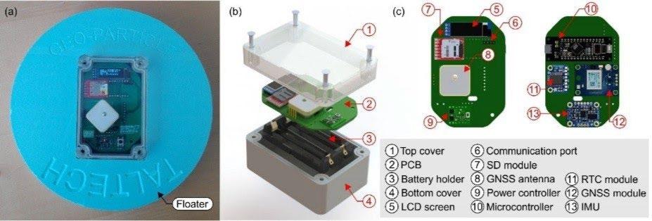
The majority of the Earth’s rivers, lakes and glaciers remain unexplored due to the high cost and complexity of conducting direct field measurements. New, easy-to-use and cost-effective methods are required for the direct measurements of the physical conditions occurring in these key surface water bodies. In addition to satellite positioning and inertial measurements, bespoke sensing payloads (e.g., water quality) can also be integrated into the existing design as needed. The GNSS sensor can also be configured for atmospheric monitoring. Widely used in maritime applications, Lagrangian multisensory drifters have been successfully implemented for the study of large-scale flows in seas and oceans, but there exists a lack of a viable commercial technology for freshwater applications. Currently, there are no commercial competitors to this technology. Applications include monitoring remote rivers, lakes and coastal regions where the sensors can be airdropped from drones or light aircraft at heights of up to 300 m. We are currently looking for firms interested in licensing the technology for commercial uses. Targeted applications include measurement of flows in rivers during flood events to improve flood risk mapping, along coastal shore protection structures and harbours, in aquaculture facilities to provide real-time information on the sea state, and in lakes and reservoirs used for water supply and hydropower. Data from multiple sensors can also be used for passive identification and tracking of surface vessels, improving situational awareness in littoral operations. The multi-sensing drifters have been funded by the ETAg PUT grant 1690 “Bioinspired flow sensing”, and have been used in the Norwegian research project “MAMMAMIA” since 2019.
KEY INFORMATION
Ocean Monitoring Indicators (OMIs) provided by the Copernicus Marine Service (CMEMS) are free downloadable trends and data sets covering the past quarter of a century.
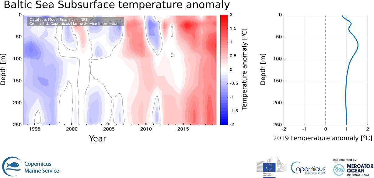
Figure: Depth/time section of annual subsurface temperature anomaly averaged over the Baltic Sea during the period of 1993-2019 and relative to the climatological period 1993-2014 from CMEMS regional reanalysis product
CONTACT
Priidik Lagemaa, PhD priidik.lagemaa@taltech.ee
DETAILS
OMIs which are based on satellite and model data are used to track the vital health signs of the Baltic Sea and signals in line with climate change. The indicators include: Baltic Sea ice extent, temperature anomaly, temperature trends, etc.
Data can be downloaded from Copernicus Marine Environment Monitoring Service web site: marine.copernicus.eu/science-learning/ ocean-monitoring-indicators
Baltic Sea OMIs are calculated by the Baltic Sea Monitoring and Forecasting Centre (BAL MFC) which includes five leading operational oceanography centres around the Baltic Sea: Marine Systems Institute at Tallinn University of Technology (MSI), Bundesamt für Seeschifffahrt und Hydrographie (BSH), Danish Meteorological Institute (DMI), Finnish Meteorological Institute (FMI), Swedish Meteorological and Hydrological Institute (SMHI).
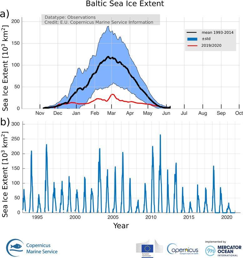
Figure:
(a) Time series of average sea ice extent derived from remote sensing and in situ observations. Long-term mean (black line) and one standard deviation (blue shading) are calculated over the period October 1992 – September 2014. Daily sea-ice extent is for 2019/2020 ice season (red line).
(b) Time series of the area integrated daily sea-ice extent for the Baltic Sea in 1993–2020. Initial data are smoothed using 7-day window moving average filter
Data processing prototype for mapping open water and water under vegetation from Sentinel-1 satellite imagery. A prototype will be implemented as an operational service by the Estonian Environment Agency. A future plan is to export the methodology to public services in Latvia, Lithuania and Belarus.
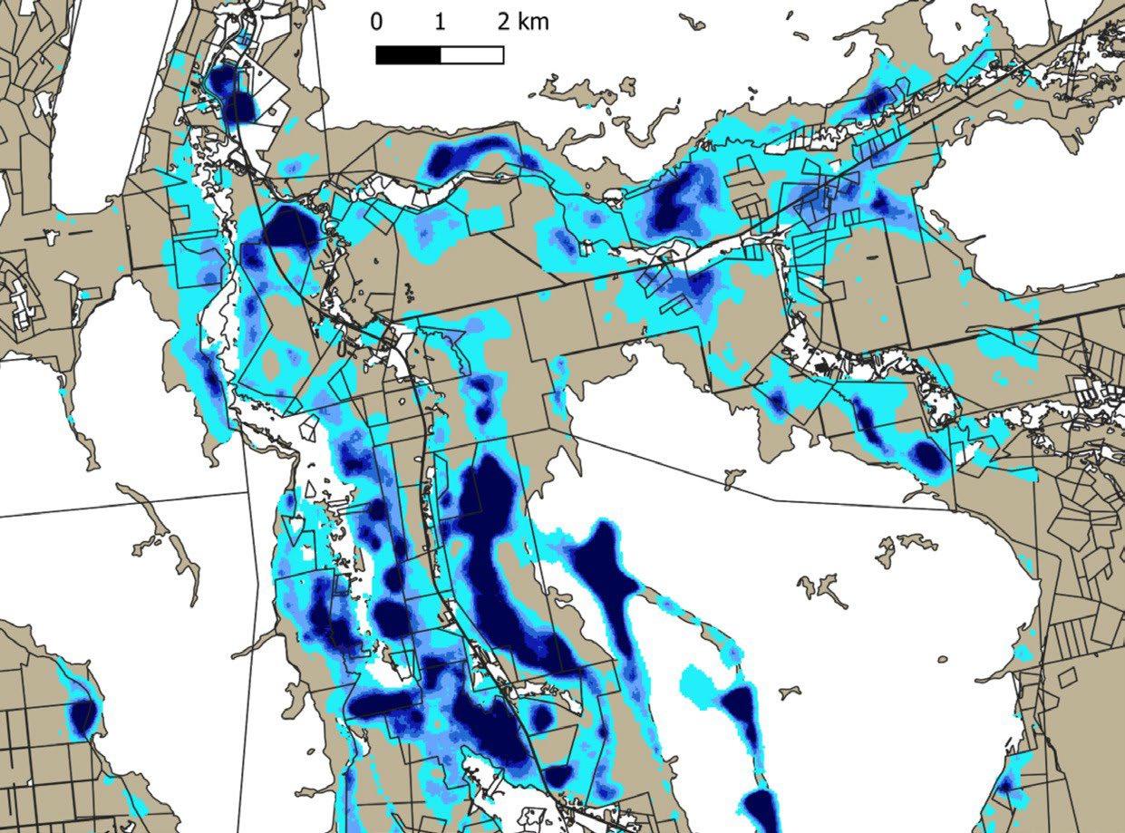
CONTACT
Liis Sipelgas, PhD liis.sipelgas@taltech.ee +372 532 67509
The methodology enables operational mapping of open water (including flood) and water under vegetation from Sentinel-1 imagery. The data processing set up also allows deriving statistical information about flood frequency inside the area of interest (defined area). Processing steps include automation downloading of EO data, pre-processing of Sentinel-1, raster based water mapping and post processing for filtering false alms (look-alikes). Testing showed the accuracy of the water mapping from Sentinel- 1 is 95%.
Machine learning methods are implemented for operational processing of Earth observation data from the Copernicus program to retrieve sea ice information over the Baltic Sea and Estonian lakes.
TALLINN
CONTACT
Rivo Uiboupin, PhD rivo.uiboupin@taltech.ee +372 620 4302
The development will provide operational and accurate sea ice charts and lake ice extent products to professional users and to the public in Estonia. Operational processing of the EO data ensures timely distribution of ice information via Web Map Service (WMS) and interactive webpage for public use (navigation, safety, tourism). The Estonian Environment Agency and IT Centre of the Ministry of the Environment are responsible for the routine operations of the ice monitoring service.
The Department of Marine Systems at Tallinn University of Technology and CGI Estonia are responsible for: (1) Development of the operational algorithms that enable to derive ice extent, type, concentration, thickness and snow cover from the Sentinel-1,-2 and-3 imagery; (2) The ICT modules which enable to archive the satellite sea ice products, deliver the products to expert users and distribute the ice info to general public via WMS service and web page.
The Estonian Weather Service is a national ice service in Estonia. During the winter navigation period, the Estonian Weather Service is responsible for providing daily ice reports (marine bulletin) and sea-ice charts over the exclusive economic zone and internal waters of Estonia. The operational sea ice service is based on a manual interpretation of satellite data and ground measurements.
The sea ice information is relevant for the transportation sector and ice breaking services as the accurate and timely information can reduce the fuel consumption of an ice breakers by 20%. The improved ice breaking service reduces the waiting time and atmospheric emission/ pollution of cargo vessels that in turn reduces the costs of vessel operators.
Secondly, the coastal and lake ice information provided by the service is relevant for safety reasons (permission to go on ice) and for planning re-creational activities, such as fishing and hiking on the ice. Moreover, in case of accidents (e.g., people on drift ice) the satellite data enables to carry out Search and Rescue missions on sea and lake ice.
Krakul has been the design and development partner for many tech companies from all over the globe, having its roots in space, unmanned aerial vehicle (UAV) and unmanned ground vehicle (UGV) sectors. We offer design services including embedded systems development and prototyping, all the way from Proof of Concept (POC) to manufacturing.
KRAKUL www.krakul.eu
Kristjan Tozen kristjan@krakul.eu +372 5885 6921
Krakul was one of the main developers of Crystalspace’s Lunar Stereo Cameras, the first Estonian technology on the Moon. Crystalspace was selected by Maxar Technologies, a trusted partner and innovator in Earth Intelligence and Space Infrastructure, to build two stereo cameras that will work in tandem monitoring a robotic arm collecting regolith samples from the Moon. The stereo cameras will be part of Maxar’s robotic arm called Sample Aquisition, Morphology Filtering, and Probing of Lunar Regolith (SAMPLR). Krakul had the opportunity to provide Crystalspace with electronics and embedded software design for the cameras which have to withstand extreme conditions.
Krakul is a design partner with long-term and versatile experience offering complete product solutions - supporting you in all of your IoT-related projects, from idea to manufacturing. Completing over 100+ projects, the team has had a global influence, with projects in the Baltics, Sweden, Mexico, Vietnam, Spain, and many other countries. Krakul is part of Bercman Technologies group, a Nasdaq First North listed deep-tech company developing traffic safety solutions.
Main fields of activity: space technology, unmanned aerial systems, autonomous vehicles