

CONTENTS
OBJECTIVE 4 MECHANISM 5 TESTING GROUND ONE 6 PERSONAL DESIGN THEORY 7 TESTING 10 TESTING OUTCOMES. 12 RELFECTION 12 TESTING GROUND TWO 13 OBJECTIVE 14 UNPACKING THE CLASSIC 15 DISTILLING THE MAPPING LANGUAGE 16 FOV MECHANISM 16 BUILDING REPRESENTATION > SPATIAL ORDERING 18 LINE TEST ONE 19 SPATIAL ORDERING > PERMABILITY CLASSIFICATION 20 CLASSIFICATION TEST 21 SPATIAL ORDERING > VIGNETTES 22 SPATIAL ORDERING > THE GRID 23 TESTING GROUND THREE 24 OBJECTIVE: 25 APPLICATION OF SPATAIL THEROY 26
REFLECTION DEVELOPMENT 27 BUILDING EXPRESSION 28 APPLICATION OF SPATAIL THEROY : BUILDING REPRESENTATION 29 APPLICATION OF SPATAIL THEROY 30 APPLICATION OF SPATAIL THEROY 31 UNITIES OF AMBIANCE 32 DEVELOPMENT 35 LIVING NOISE 37 MECHANICAL NOISE 38 UNITIES OF AMBIANCE 39 CHOREOMATIC DIAGRAMS 40 APPLICATION OF CHOREMES 43 DEVELOPMENT 44 LEGENDS 45 FINAL MAPPING BEFORE COLLATION 46 FINAL MAPPIING 47 REFERENCES 48 APENDIX 49
Ambiguous Grid-Ed. Robinson-2022
OBJECTIVE
THE INVARIANT AND THE COMPONENTS
While placing oneself the physical urban grid, we call the city, spaces go unnoticed. The flow, perceived as freedom, controlled by users and structures impose permeability constraints.
Mapping languages stem from centuries of mapping evolution. Examples from the first atlas of Willam Playfair in 1786 to the development of cartography iconography in Jaques Bertin’s Semiology of Graphics, the 2010 edition, acknowledge the developing world and challenges of representing data. Data which captures, translates and talks to the ever-evolving use of space.
Howard Wainer, highlighted the challenge of representing data within contemporary practice with his quote, “the revolution of data gathering, analysis and display taking place in the last decades of the twentieth century would have resulted in the complexities of the modern world being conveyed in bullet points, PowerPoint and Excel graphics.”
A more recent development of this idea is observable as users interact with map data on a digital device. However, argued, digital platforms remove the haptic analysis which only comes from holding a physical map. Physical maps enable the user to rotate and orientate oneself within the landscape. The unfolding allows users to not only find their route, but also discover a comprehensive understanding of the landscape around them and during their journey.
Thus, to extend the development of a mapping language into the digital form, I explore the relationship and expression of space through the realm of permeability in a qualitative and quantitative existence.
Mapping techniques explored, tested and refined in this visual essay aim to reveal smaller spaces of the ‘in-between’ and the reality of the controlled urban grid form..
Ambiguous Grid-Ed. Robinson-2022
MECHANISM
MECHANISM OF INVESTIGATION
To first explore the Hoddle Grid with a new pair of eyes, the mechanism used is the Dérive - which aims to understand, view and organise the many layers of information encapsulated within the forms of physicality.
The term dérive was first coined by the situationists - a technique of walking through varied spaces with a predefined set of rules to observe the appeals of terrain and encounters found in a space. Altering Behaviour and awareness, psychogeography effects become discernible from an everyday walk or stroll.
Removing the structures of cartography, Guy Debord operates the Dérive for his psychogeographic map entitled ‘The Naked City” (1957). Intentionally deconstructed, Debord’s arrangement of 19 districts of Paris illustrates a “subjective and temporal experience of the city as opposed to the seemingly omnipotent perspective of the planimetric map” (Sant, A. 2006).

Deboards description of a derive:
“In a derive one or more persons during a certain period drop their relations, their work and leisure activities, and all their other usual motives for movement and action, and let themselves be drawn by the attractions of the terrain and the encounters they find there” (London 1969)
(Debord, G 1957)
Ambiguous Grid-Ed. Robinson-2022
TESTING GROUND ONE
PERSONAL DESIGN THEORY
Through the correlation and collection of data (nouns) taken from the three Dérives across the entire collective, words have been taken to start the collection anthology as a foundation for developing a new mapping language. These words are then used to create an iconology to aid in the visual representations of each dérive. The concept is mixed with the opacity and placements of specific underlying city grids. Exploration is developed by the restrictions or application of the following frameworks for the new mapping language.
Nouns Icons Vingettes Matrix
The development of these layers through each dérive informs the next and, through further exploration or combination of these layers, will create and inform the new mapping language. The development of these layers through each dérive informs the next and, through further exploration or combination of these layers, will create and inform the new mapping language. Through further iterations, the nouns and icons become complementary language when engaged in parallel formation. In each instance, the noun and icon combination is used to aid in the description of the psychogeographic ambience of the in-between space.
ICON NOUN TABLE


AEROPLANE
Ambiguous Grid-Ed. Robinson-2022
PACE
TRAM
CONJUNCTION
CONTROL SHUFFLE
BIKE DRAIN WINDY
CONVERSATION NOISE WET ROUTE TRANSITION
PIGEONS CROWD
THOROUGHFARE LOOSE
DARK LIGHT
WARM SMELL
ALARM COLD DISSAPAER CONFUSION
VIEWING THE CITY THROUGH THE SOUNDSCAPE.
To view the city through a different pair of eyes, where the visual is disregarded, and the new paintbrush is sound. It guides and exposes the city in a view you've never experienced, the direction of which is controlled by sensing places and robots. Then cold, wet weather is more noticeable on your body than before. The city fabric and cacophony of noise that entangles its way through becomes a tangible thread that can guide, teach and follow. The colours and signage become blurred and indistinguishable from the brickwork of the buildings. The buildings themselves act as amplifiers for the soundscape, birds chirping audible over the users of the fabric, both human and mechanical. Water the overwhelming noise carrier in both tight and loose places—the dérive uncovering both of the latter
MAPPING OF DÉRIVE SEQUENCE ONE - A SOUNDSCAPE
Development of layers through each dérive informs the next to the creation of a new mapping language. Layers explored or combined.
Ambiguous Grid-Ed. Robinson-2022
Mapping of dérive number one - a soundscape

Ambiguous Grid-Ed. Robinson-2022
USING VIGNETTES

Through an exploration of language development, the top-down approach of mapping is further challenged. A focused look, using vignettes, explores the the urban grid. Vignettes capture time and space-specific feelings to represent the psychogeography. Influenced by the way Kevin Lynch informed his work. Using four motives of ‘an interest in the connection between psychology and the urban environment; fascination with the aesthetics of the city...questions about how to evaluate a city; and a commitment to pay more attention to the actual human experience of a city.” (Wood 2020)


TESTING
Using Debord’s method of deconstruction, the first iteration of Dérive layers information on a disassembled grid. Layering the route and developing icon noun language translates the original into a mapping of ambience through soundscape capture.
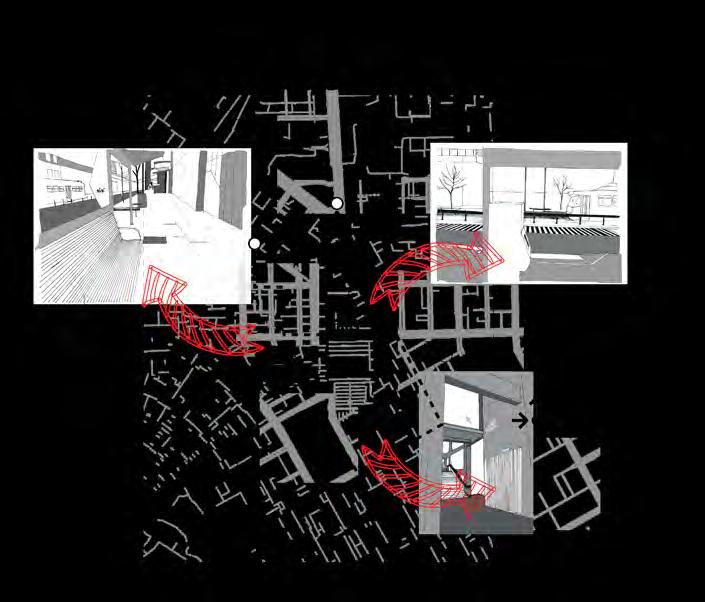
Removing the deconstructed grid and any sign of spatial orientation, icons and vignettes reveal the ambience of space. Without noun placement the closed language of icons removes the feelings of ambience. Icons represent a mechanical format open to the individual’s interpretation of the symbol.
The red arrows take visual hierarchy away from the mapping and directs the viewer to empty landscape vignettes.
Ambiguous Grid-Ed. Robinson-2022

Removing icons and nouns, replaced with a simple directional route, exposes the lack of indicators of quality. Placement of nouns alludes to spaces of the in-between, the lack of locationspecific indicators remove any relatability to the viewer.
Combining elements from the previous three generations. Change of arrow colour alters the hierarchy and removing vignettes aids in an even translation of information. Ambience is perceived but with less effect than a tourist map, where directions and place-specific feelings that can occur when following the route.

Ambiguous Grid-Ed. Robinson-2022

TESTING OUTCOMES.
Avoid using icons within the later mapping language stage; the iteration testing process reveals icons contain closed information and limits the viewer’s interpretation.
The use of noun placement can speak to the meaning of introduced icons, however the combination does not resolve the issue.
Use of the vignettes has not been explored enough within this four-stage testing sequence, so it will explore further in stage two.
Use of colour is also carried across to further testing within stage two, exploring themes of ability in the informational hierarchy process of experiencing space.
The use of arrows limits and directs the viewer to controlled information. As with icons, this detracts from the mapping’s ability to translate information on a multi-scalar level.
RELFECTION
THE URBAN MATRIX FOLLOWED THROUGH OTHERS’ EYES.
Through the flow of the city and the urban matrix controlled not by robots but by the attraction or repulsion of others, the drag of the crowd the flow of the city created by its users. The procession of humans equates to the ebb of a steady stream down the canyons of city streets. Skyscrapers become guiding barriers, like water through sandstone, the erosion of the person replaced by place and anonymity—the odd moment of vulnerability out in the open space of the street. The cacophony of faces gives safety in the busy streets—incidents of hanging out knowing tangible at every turn.
Ambiguous Grid-Ed. Robinson-2022
TESTING GROUND TWO
Ambiguous Grid-Ed. Robinson-2022
OBJECTIVE
DEVELOPMENT OF LANGUAGE
Building on experiences during the first testing sequence, development of language further explores the space of the in-between and what the drivers of this ambiguous creation are.
Is the space a direct result of the construction of the grid imposed to control? Does the grid acknowledge creation of secondary spaces or the spaces inbetween, or are these a direct consequence of the stakeholder’s intention? If so, what are the restrictions? Does permeability alter viewer’s perception of space, or is it a directional function of control?
Taking rules from Jaques Bertin theory that “a component is characterised as qualitative ordered or quantitative and that each visual part must ‘permit a parallel perpetual approach,” mapping language should engage both cartography’s terrestrial and aerial platforms.
Platforms should read a consistent language but offer different interpretations, [from a classical route map to a personalised qualitative take on the spacespecific permeability of each local.]
Components have a consistency and order of organisation. This facilitates understanding when read as separate or grouped. Each component adds edge conditions.
Adding the layer of components to the mapping as the starting driver help develop and explore the ideations of the new language.
Ambiguous Grid-Ed. Robinson-2022
SCALE ONE: Elements of space represented in solid lines and coloured blocks with icon use.
SCALE TWO: Solid lines depict road networks, space composition omitted, arrows aid in understanding flow direction.

SCALE THREE: Solid and dashed lines represent road networks. All qualitative compositions of space omitted.

UNPACKING THE CLASSIC
Classic cartography mappings lack the ability to read qualitative composition, although they vary in scale. Lines depict roads and pathways with flow lines. Omission of building and the use of white and orange creates an ambiguous feeling of nothingness, giving the illusion that the city grid is flat, perhaps with open spaces depicted on the white zones - as a user of the space in the physical form we know this to be untrue. Classic maps present a mechanical rhythm, and its information suggests a viewer is a machine.

The use of varying line weights, the level of information included at different scales, and how affecting the visual feel and, in turn, the user’s emotional response succeeds in its relatability and its aim, which is to be direct.
Ambiguous Grid-Ed. Robinson-2022
DISTILLING THE MAPPING LANGUAGE FOV MECHANISM
Using building representation as the first point of evaluation for the language.
Building representations provide understanding of the space buildings create, either directly or indirectly, or the in-between.
Buildings create linear exclusions, physical and visual impermeable areas. Spaces between are classified at a permeable level.
As the driver, the human body interprets spaces and classifies their valuation and order..
Sight the driver mechanism for valuation, order and their representation - leads to exploring the three realms of vision: peripheral, vertical, and central.
With these three fields deconstructed and explored, the maximums of each create a visual model which provides an understanding of the field of view (FOV) used to create the new mapping language. .
DRIVER (HUMAN)
VEHICLE ROUTES
PEDESTRIAN ROUTES BUILDING REPRESENTATION
Ambiguous Grid-Ed. Robinson-2022

FOV REPRESENTATION
DRIVER (HUMAN)
PERIPHERAL CENTRAL VERTICAL

BUILDING REPRESENTATION > SPATIAL ORDERING
BUILDING REPRESENTATION
OBJECTIVE
Develop a non-traditional linear representation which forms a spatial understanding of the space while adding a parallel perception.
DEVELOPMENT
An understanding of space and its qualities must be definable while reading a map. Further expanding classification builds on the traditional cartography representation of permeable or impermeable. Through development, expanded classifications as follow:
VISUAL PERMEABILITY
SPATIAL ORDERING
PARALLEL ORDERING
IMPERMEABLE PERMEABLE
» Visibility to Public Space
» Visibility to private space
» No visibility
PHYSICAL PERMEABILITY
» Open Access
» Controlled access private (Pedestrian)
» Controlled access (Vehicle)
Classification uses a theory from Jaques Bertin where “The visual variables must have a level of organisation at least equal to that of the components which they represent.”
Colour aids in representation of line expression, based on the traditional and recognisable traffic light system of red, yellow and green.
Ambiguous Grid-Ed. Robinson-2022
LINE TEST ONE
TESTING LINEAR REPRESENTATION OF TRADITIONAL CARTOGRAPHY SPATIAL CLASSIFICATION. LINE
THE WORDS ARE TAKEN AND ASSEMBLED INTO MORSE CODE.
TEXT CODE LINEAR

PERMEABLE .--. . .-. -- . .- -... .-.. .
Following the rule of organisation and using the edge condition quantitative terms of impermeable and permeable, the code is tuned into lines.
Line weight hierarchy based on Jaques Bertin's theory that 'the visual variables must have a level of organisation at least equal to that of the components which they represent."
BUILDING REPRESENTATION SPATIAL ORDERING LINEAR REPRESENTATION
Review:
As lines conform to the spatial ordering of existing permeability, an accurate spatial representation of access and visual permeability is missing, including their qualitative effects.
Lines reduce the representational plane to access or no access removing qualitative effects that from this map. This test aided in reclassification undertaken when developing the new liner representation.
Ambiguous Grid-Ed. Robinson-2022




SPATIAL ORDERING > VIGNETTES
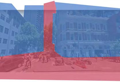
Re-engaging vignettes, this iteration applies spatial ordering classification. Building a multilayered visual reference that starts to indicate levels of permeability as foundations for these vignettes. Exploring the representation of space ambiences experienced through the driver, the human body. The final layer is added to vignettes, which used in conjunction with the final mapping language as either as callouts or as a collaged image


Once ambience representation has been explored, placement and hierarchy of these will be explored.

VIGNETTE ITERATION 1

MAKEUP THE GRID USE OF THE GRID
COLOUR THE GRID VIGNETTE ITERATION 2 VIGNETTE ITERATION 3
Adding blur to the human use layer of the vignette; introduces a hierarchy of information as each layer adds the amount of information gained from a single image.
SPATIAL ORDERING > THE GRID


Exploring spatial domains of the urban grid, applied since the early 1700s, mapping system manifests itself as a mechanism of colonisation and control and one which is a totalitarian approach.

Understanding the layers that compose the grid must be further understood and analysed to inform the development of future mapping languages.
This exposes the lack of space-specific ambiences and expressions of the in-between, which this new language is looking to convey.
Separating the layers, into buildings, private vehicle roads, public transport roads and pedestrian walkways, the spatial ordering is broken-down and will be rearranged, reclassified and rebuilt in a bottom-up approach to forming new language.
To keep tests consistent, workings are now in scale to simplify the comparison of the various components of the language.
Pedestrian walkways Buildings Private vehicle roads Public transport roads
Ambiguous Grid-Ed. Robinson-2022

TESTING GROUND THREE
OBJECTIVE:
To apply spatial ordering and representation research to a map at scale.
Using the FOV mechanism to record information, primary classification of space, and its permeabilities, gained from the immediately viewed frontages of the street-scape.


The secondary FOV mechanism of vertical view records buildings’ height, explored as the next step after the spatial ordering of frontages has taken place.
OPEN ACCESS (OP)
SCALE: 1:2500 @ A4
NO VISIBILITY (NV)
SCALE: 1:2500 @ A4
CONTROLLED VECHILE ACCESS (CVA)
SCALE: 1:2500 @ A4
CONTROLED PUBLIC ACCESS (CPA)
SCALE: 1:2500 @ A4
VISIBILITY PUBLIC (VPU)
SCALE: 1:2500 @ A4
Ambiguous Grid-Ed. Robinson-2022
VISIBILITY PRIVATE (VP)
SCALE: 1:2500 @ A4


REFLECTION DEVELOPMENT
Using the ideals brought about by Conzen, Muratori and Moudiobn in various studies of representational hatching from the 1960s to the 1980s, develop representations of spatial qualities as rectangles in the representational colour and the physical permeable space. This helps distinguish between humans’ and machines’ visual and physical permeability.
TEST 1 TEST 2
Ambiguous Grid-Ed. Robinson-2022


BUILDING EXPRESSION
OBJECTIVE:
Exploring the spaces of the in-between, created during representation of buildings and their lack of vertical appreciation. Use of hatching and its density represent the varying building scapes present in this space.
In doing so, the hatch based on a geometric grid pattern each rotated 45 degrees for different building heights, are the same angles at which a grid is created.


The denser the hatch, the higher the building. Building overhangs are also acknowledged, which appear in the vertical plane of the spatial qualitative assessment.

Buildings of various heights with overhang
Buildings of more than two levels with no overhang
Multi-story building with various overhangs at various levels
Overhang
Skyscraper height buildings
Skyscraper height with overhang
Single story building
Overhang
Overhang
APPLICATION OF SPATAIL
THEROY : BUILDING REPRESENTATION
Due to the grey scale used in the hatching process, a slight refinement of colour on the FOV mechanism is required to distinguish the difference between each hatch to amplify the changes in layers and information they communicate.
Mechanism
SCALE: 1:2500 @ A4

APPLICATION OF SPATAIL THEROY
Adjusting opacity of the lined spatial theory introduces hierarchy to readability and opens a dialogue between the two layers of information.
Following ambience exploration in the next chapter, the final stages of curation of the language will be to take a further look at the rules of hierarchy, and the application of opacity to aid in visual translation of information.
FOV Mechanism not to scale
SCALE: 1:2500 @ A4

APPLICATION OF SPATAIL THEROY
TEST 2
FOV Mechanism not to scale
SCALE: 1:2500 @ A4
VISUAL PERMEABILITY PHYSCIAL PERMABILITY
Visibility to Private Space
Visibility to Public Space

Controlled acces (Vechile)

Open Access
Contorlled acces priavte (Pedestrain)
No Visibility
UNITIES OF AMBIANCE
OBJECTIVE:
In Rethinking the Power of Maps, Fenis Wood reveals that the cadastral mapping techniques of the modern language expose a lack of tactile qualities, which creates a map that is “an instrument of control which both reflects and consolidates the power of those who commission it”.
Fusing Wood’s statement with the Situationist’s belief in the Dérive’s capabilities, we can expand the haptic feeling of the buildings that make up the map. Not through the depiction of the materiality of the building but its height. Combining this with representations of ambience explored in the next chapter, we explore relationships between each graphical representation while achieving a synthesis of readability.
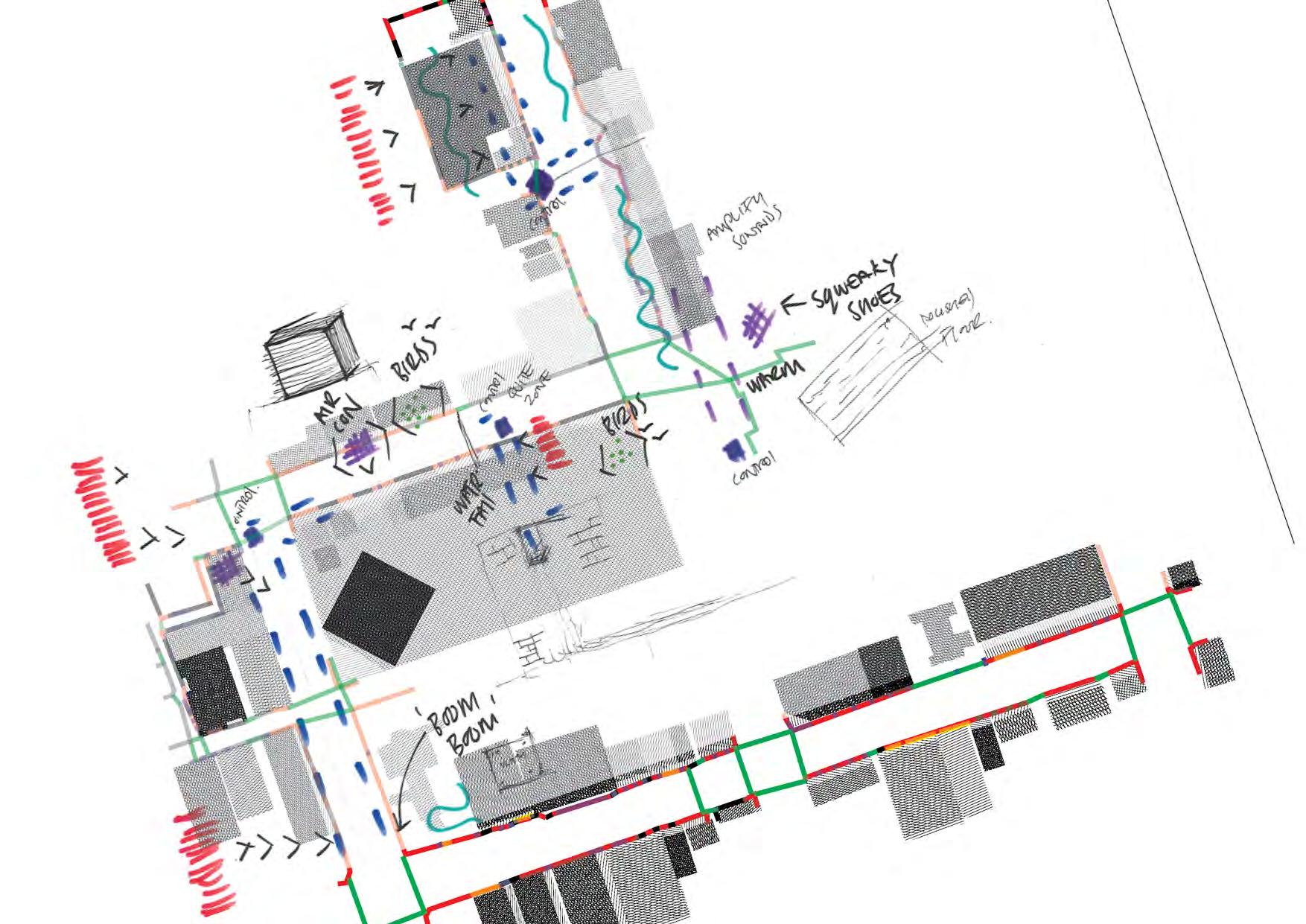
EXAMPLES OF AMBIENCES FROM DÉRIVE TWO - DESCRIPTIONS OF VARIOUS SOUND AND PHYSICAL AMBIENCES EXPERIENCED.

CURRENT THEORY
MAPPING OVERLAYED ON DÉRIVE 1 SOUNDSCAPE
UNITIES OF AMBIANCE
The unities of ambiance were constituted by many things, especially the “soft,” mutable elements of the city scene: the play of presence and absence, of light and sound, of human activity, even of time and the association of ideas. The “hard” elements, like the shape, size, and placement of masonry, gently articulated the softnesses in between. (Wood 2012)
Examples of ambiences from Dérive two - or descriptions of various sound and physical ambiences experienced.


The first building block for the development of ambience representations. Using knowledge gained from icon use and the closed languages they connate from testing ground one. .

DEVELOPMENT
Developing the representation of noise is the first exploration of the ambience unities.
Deciphering an expression based on physical sight of slow and fast noises categorised from dérive one and two.
Visual representations then further develop to complement the hatching of the building. This indicates and engages in a stippling effect with various spaces between sound curves. Stippling visually represents the transient nature of sound and realises some of the ambiguity and depth/distance, compared to a static line of expression.

development
TESTING GROUND ONE
NOISE

Lineear Rep.
Stippling Rep.
Ambiguous Grid-Ed. Robinson-2022
From Mapping as Spatial Knowledge, in Mapping Urbanities: Morphologies, Flows, Possibilities, application of colour further distinguishes the difference between mechanical noise and living noise. Both of which described below. Applying colour, the risk of stippling being lost to the grey-scale hatching of buildings is mitigated.
Further classification of sounds experienced on both dérive one and two aid in applying the stippling to the mapping language.


MECHANICAL NOISE
Sounds made by or come from mechanical systems.
AIRCON TRAFFIC
testing ground one
testing ground one
LIVING NOISE
Sounds emanating from a living source, including weather systems (e.g., wind)
WINDY PIGEONS
TRAM ALARM CONVERSATION WET WALKING
LIVING NOISE


testing ground one linear representation Stippling directional axis


PIGEONS


CONVERSATION
WALKING WINDY
MECHANICAL NOISE


testing ground one linear representation Stippling directional axis




AIRCON
TRAFFIC TRAM ALARM


CHOREOMATIC DIAGRAMS
OBJECTIVE:
Using Roger Brunet’s evolution of geographical space and its organisation to explores the development of the first dérive. How this can aid in developing a new mapping language that could be adopted.
Brunets term chorèmes is given to structures to spatially organise a landscape. In doing so, he states that a model is always a simplification of reality, of one’s vision of that reality.
Taking Brunet’s geographical representations the dérive develops into a mapping of qualitative phenomena viewed by the author.
Ambiguous Grid-Ed. Robinson-2022

DEVELOPMENT
Applying the chorèmes to dérive one and experimenting with size, hierarchy and opacity. This approach takes the representations of attraction areas, directional movement, preferred relationships and applies these to the current theory of mapping. In doing so, I will be conscious of how representation and what qualitative effect (if any) it is trying to impart to the viewer.
NO OPACITY SIZE
hierarchy hierarchy hierarchy
Ambiguous Grid-Ed. Robinson-2022
PREFERRED
APPLICATION OF CHOREMES TEST
FOV Mechanism not to scale
SCALE: 1:2500 @ A4

DEVELOPMENT
During the iteration of mapping dialogue, the creation of layers, readability of information is the first driver. The final refinement process was the allocation of information hierarchy. Using information gained in the Choremes research chapter, layers now represent the information’s necessity.
Experimentation of scale and callouts will be used in the final composite mapping, highlighting and revealing relationships of the in-between. Callouts will be based on the location of the FOV mechanism and consist of all layers covered in this research essay; they are:
» Unities of ambience
» Building Expression
» Vignettes
» Spatial Theory
» Choreomatic Diagrams
» Choreomatic Diagrams


The ‘callouts’ or ‘gems ‘of the city, as Nason 2018 refers to them, add a final layer of observations to further qualify values attainable from FOV mechanisms throughout the mapping. Increasing the scale amplifies these ‘gems’ using hierarchy as the driver for the final layer of information.


Unities Of Ambience Building Expression

Vignettes
Spatial Theory Choreomatic Diagrams
Ambiguous Grid-Ed. Robinson-2022

LEGENDS
SPATIAL THEORY


UNITIES OF AMBIENCE
CHOREOMATIC DIAGRAMS
Ambiguous Grid-Ed. Robinson-2022


REFERENCES
Bertin, Jacques, and William J. Berg. Semiology of Graphics: Diagrams, Networks, Maps. 1st ed. Redlands, Calif: ESRI, 2011
Chorème, Chorématique (2017) Chorème, chorématique - Géoconfluences. Available at: https://geoconfluences-ens--lyon-fr.translate.goog/glossaire/ chorematique?_x_tr_sch=http&_x_tr_sl=fr&_x_tr_tl=en&_x_tr_hl=en&_x_tr_pto=sc
Debord, G. (2014) The Naked City, the-naked-city-guy-Debord-1957. wordpress.com.
Ferretto, P. CHASING AMBIGUOUS CONDITIONS OF COEXISTENCE in Chasing the City : Models for ExtraUrban Investigations, edited by Joshua M. Nason, and Jeffrey S. Nesbit, Taylor & Francis Group, 2018
Nason, Joshua M., and Jeffrey S. Nesbit. Chasing the City: Models for Extra-Urban Investigations. Milton: Taylor & Francis Group, 2018. Print
Pyyry, Noora. "From Psychogeography to Hanging-out-knowing: Situationist Dérive in Nonrepresentational Urban Research." Area (London 1969) 51.2 (2019): 315–323. Web. q1à
Sant, A. (2006). REDEFINING THE BASE MAP.
Wood, D., 2020. Psychogeography. In: Kobayashi, A. (Ed.), International Encyclopedia of Human Geography, 2nd edition. vol. 11, Elsevier, pp. 65–68.
Wood, Denis., John. Fels, and John. Krygier. Rethinking the Power of Maps. New York: Guilford Press, 2010. Print.
Ambiguous Grid-Ed. Robinson-2022
APENDIX
ADDITIONAL RESEARCH
Although variable in their information and representation, Icons follow a composition that consists of 4 sectors that are equal in shape and size; using this essential icon format distillation, traditional language is applied to form coders that could be placed above or within the new edge condition linear format.

P E R M
P E R M
Following the rule of organisation and using the edge condition quantitative terms of impermeable and permeable along with the qualitative nouns explored in milestone one, a table of codes is established using the first four letters of the word to drive the formation of a legend. The further organisation places the four letters alphabetically in the icon grid.
Ambiguous Grid-Ed. Robinson-2022
Combing an ariel map with a terrestrial plane on the same journey, I argue that this method can imply and reveal existing relationships with the built environment, even if these relationships are fleeting and a time capture of a moment. Altering the visual representation of traditional surfaces through the evolution of these surface labels into a binary code.
CHOREMES EXPLORATION
Using the same terms as the icon code format (permeable and impermeable), code can start to be overlayed with the traditional vision of a vignette to reveal more qualitative values of the space. While applying the coded nouns to the location in the relevant vignette enables a tangible connection for the reader to place themselves in the landscape at that time.

Ambiguous Grid-Ed. Robinson-2022

GROUP DÉRIVES

Ambiguous Grid-Ed. Robinson-2022


