3 minute read
Campo Ayatsil y su análisis geológico


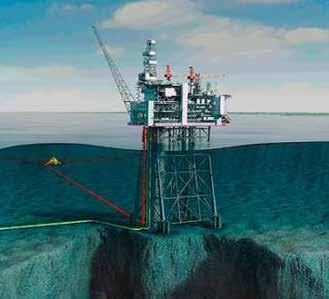
El campo Ayatsil se ubica en áreas territoriales del Golfo de México a 130 km al noroeste de Ciudad del Carmen, Campeche. Geológicamente, el campo se ubica en la porción Nororiental del Pilar de Akal, a un costado de la Fosa de Comalcalco.

Por / By : Madaín Moreno Vidal, Gabriel Martinez Hernández, Aarón Gutiérrez Araiza, Xóchitl Gisela Medellín Pérez, y Alfonso Palacios
Para los ingenieros, el campo representó un análisis de información geológica y de consistencia en la interpretación sísmica estructural, con base en patrones sísmicos y análisis de velocidades. En un principio se pensó que no había oportunidades en esa área, pues la unidad Brecha Cretácico Superior (BKS) parecía invadida por su diferencia estructural con los campos aledaños: Maloob y Pohp-Tson.
Posteriormente, el grupo de trabajo logró definir el cierre estructural, calculó el recurso prospectivo y realizó la evaluación económica. En marzo del 2007 se perforó el pozo Ayatsil-1 y en junio de 2008 se delimitó con el pozo Ayatsil-DL1. Ambos pozos resultaron productores de hidrocarburos pesados (11.3°API) en BKS.
Los pozos incorporaron un volumen de 987 millones de barriles de petróleo crudo equivalente (MMbpce). Actualmente, el volumen es de 3,476 MMbpce. El campo entró a producción en febrero del 2015 y se confirmó que los pozos no eran fluyentes. Por esta razón, el desarrollo del campo inició con el sistema artificial de producción bombeo electrocentrífugo (BEC). A la fecha, el proyecto Ayatsil es un campo importante para la nación; en 2018 alcanzó una producción de aceite de 60 mil barriles por día.
Ayatsil Field and its geological analysis
The Ayatsil field is located in the Gulf of Mexico territorial areas 130 km northwest of Ciudad del Carmen, Campeche. Geologically, the field is located in the northeastern portion of Pilar de Akal, next to the Comalcalco Trench.
For the engineers, the field represented a geological information analysis and consistency in structural seismic interpretation, based on seismic patterns and velocity analysis. At first it was thought that there were no opportunities in this area, since the Upper Cretaceous Breccia unit (BKS, by its acronym in Spanish) seemed to be invaded by its structural difference with the surrounding fields: Maloob and Pohp-Tson.
Later, the work group managed to define the structural closure, calculated the prospective resource and carried out the economic evaluation. In March 2007 the Ayatsil-1 well was drilled and in June 2008 it was delimited with the Ayatsil-DL1 well. Both wells resulted in heavy hydrocarbon producers (11.3°API) in BKS.
The wells incorporated a volume of 987 million barrels of crude oil equivalent (MMboe). Currently, the volume is 3,476 MMboe. The field entered production in February 2015 and it was confirmed that the wells were not flowing. For this reason, the field development began with the artificial electrocentrifugal pumping (BEC, by its acronym in Spanish) production system. To date, the Ayatsil project is an important field for the nation; in 2018 it reached an oil production of 60 thousand barrels per day.

La metodología para la generación de localizaciones partió de analizar información geológica y geofísica alrededor de pozos exploratorios y de campos en producción; identificar y jerarquizar oportunidades exploratorias para posteriormente documentar la localización. Lo que inició como una oportunidad, hoy es un campo en producción con una estrategia de explotación. Por esto, debemos revisar todas aquellas oportunidades en los diferentes horizontes geológicos cercanos a campos con infraestructura.
The methodology for the generation of locations started from analyzing geological and geophysical information around exploratory wells and fields in production, as well as identifying and prioritizing exploration opportunities and then documenting the location. It started as an opportunity, but today it is a field in production with an exploitation strategy. Therefore, we must review all those opportunities in the different geological horizons that are close to fields with infrastructure.


