Design Results
Over a period of 16 months, our team conducted extensive research on the project site, solicited public input, and collaborated with our clients, local experts, and area residents to develop design concepts. This section presents comprehensive design concepts that incorporate our site analysis, gis modeling, literature review, boundaries, starting with Porter Legacy Dunes, followed by Syndicate Park Dunes and Van Buren State Park. These concepts are incorporated into a full extent map of the Legacy Dune Trail. included, outlining technical signage recommendations, and trail marker location recommendations. These designs are presented as working concepts, with the understanding that adjustments may be necessary based on further consultation with professional consultants and engineers. Nonetheless, the concepts provide a general layout of the trail network, highlighting key amenities such as scenic overlooks, restrooms, parking, and more.

48 Legacy Dunes Trail
4.1 Porter Legacy Dunes
The SWMLC, Van Buren County, and their partners have secured were received from donors and other organizations including Entergy Nuclear Operations Inc., the company responsible for the operation of the Palisades Nuclear Plant. Early design concepts included features such as Dyckman Creek crossings, trail signage and trail kiosks. In January of 2022 Mitch Lettow of SWMLC proposed that our team collaborate on a Michigan Natural Resources Trust Fund grant to seek additional trail development funds. This meant changing the focus of our project during
Our team worked closely with the SWMLC to help provide the supplementary materials and information necessary for the grant application. Our trail design and drawings illustrate how the trail system will serve visitors and add to the accessibility and protection of the unique dune ecosystem, especially the critical dune area.
1 utilized a minimal trail construction approach up the backdune accessible. This design reduces the amount of built trail structures as much as possible to minimize the impact within the critical
through the distinct ecosystems present at the PLD site. The second design, Concept 2, is a fully accessible trail system that utilizes modular boardwalk technology to achieve the climb up the steep backdune. A gentle slope is made possible by a trail alignment that utilizes switchbacks and short ramps that range between 5% and 10% slope for short periods followed by rest intervals.
Accessibility Guidebook for Outdoor Recreation and Trails.
49 Trail Concepts
50
Legacy Dunes Trail
1
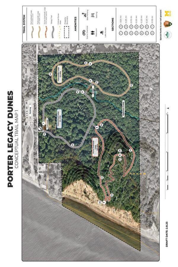
Figure 25. Porter Legacy Dunes Trail Concept
Map
4.1.1 Trail Concept 1
Homestead Loop
The ½ mile long Homestead Loop was designed to be the most accessible trail on site and is the main point of entry to the preserve. The connection to the trail entryway is conveniently located next ADA parking spaces and restrooms. The trail surface is 8’ wide and constructed using a compacted limestone base. As the name implies this loop begins at the old home site and meanders through the planted pines and into the dry-mesic southern forest. The habitat quality of the northern half of this area has been degraded by human use and includes many non-native and invasive species.
Despite that, the area also includes dry prairie and dune species including prickly pear cactus (Opuntia humifusa) and the prairie grass little bluestem (Schizachyrium scoparium opportunities for demonstrations of ecological restoration. The southern half of the loop edges into a dry-mesic southern forest that is dominated by a canopy of red oak (Quercus rubra) and young sassafras (Sassafras albidum). On the ground level visitors can enjoy a dense layer of spicebush (Lindera benzoin) and native herbaceous plants such as Solomon’s-seal (Polygonatum pubescens), jumpseed (Persicaria virginiana) and Canada Maianthemum canadense) (Bassett, and Lincoln 2022). The eastern edge of the loop hugs Dyckmans creek where also includes several features from the old homestead such as the chimney and wind turbine that could be used for interpretation of the cultural history of the site.
Flatwoods Loop
intentionally placed in the interior of the preserve to prevent 18th Avenue. The trail maintains a safe distance from the road encouraging visitors to loop back to the bridge and exit via the Homestead Loop. The eastern edge of the site is primarily acidic forest experience as the homestead loop with a canopy of red
51 Trail Concepts
oak, black gum (Nyssa sylvatica) and white pine (Pinus strobus). What sets this area apart is the abundance of greenbrier (Smilax rotundifolia) that can have prickles that can be unpleasant to hike through. Fortunately the trail will be wide enough for walkers and wheelchairs to pass by with ease, and the greenbrier can be an incentive to stay on the trail.
Dune Overlook Loop
By far the most interesting and challenging loop is the dune overlook. Visitors can make their way up the backdune from the Homestead Loop or via the trail connection with the Syndicate Dune Park. The main attraction of this loop is an opening in the canopy on top of a dune that overlooks Lake Michigan. The ascent along the northern slope crosses through high quality and diverse northern mesic forest with an estimated 99 native plant species. This mature second-growth forest boasts a much older and larger red oak canopy with dense patches of Paw-paw trees (Asimina triloba) scattered throughout the subcanopy. During the spring, visitors will be wowed by the abundance of dazzling spring ephemerals such as dutchmen’s breeches (Dicentra cucullaria), common trillium ( ), Yellow trout lily (Erythronium americanum), and many more ephemerals, some of which are rare or threatened in the state.
We took great pains to explore options for access up the steep and biologically diverse slope while simultaneously preventing
According to Hammit et al. (2015, 140) shade adapted plants found in the mesic northern forest are “generally susceptible to trampling due to their large leaves and thin stems”. To help minimize trail around the locations of rare species and sensitive areas. These site visits. The native vegetation plays an important role in the stabilization of the dune . If that vegetation were to be lost due to trampling, the area would become more vulnerable to erosion and more prone to the invasion of exotic invasive plant species.
To minimize erosion and enhance trail sustainability the trails that ascended the dune were oriented perpendicular with the prevailing slope to allow for gradual accents wherever possible. Trails that follow the contours of the land are known as sidehill trails and they
52 Legacy Dunes Trail
have a high slope alignment angle (Smith 2006). These trails are landscape. It is recommended that hiking trails do not exceed 5-12% grade and only exceed that range for short sections. (Hesselbarth 2000). Maintaining a high slope alignment angle is especially important considering the loose substrate that underlie the hillslopes of PLD. The addition of rolling grades or drainage dips can be incorporated along steeper trail sections at intervals of 20 to
grades are best installed during trail construction and essentially involve a gentle fall in the grade for a short distance that rises back up. The low points become a miniature watershed that gather and
4.1.2 Trail Concept 2
On February 8th 2023 a trail summit meeting was organized managers and ecologists to discuss the viability of various trail concepts and recommend possible improvements. Members present included the park manager of Sleeping Bear Dunes National Lakeshore, Technical experts of the National Park Service and the Superintendent of Indiana Dunes State Park. After consulting with trail experts from across the region, it was decided to design the trail system taking a universal design approach. According to the Forest Service Trail Accessibility Guidelines (FSTAG) universal
“The principle that programs and facilities must be designed to be usable by all people, to the greatest extent possible, without separate or segregated access for people with disabilities.”
The Homestead and Flatwoods Loops remain relatively unchanged as they are on fairly level terrain. The dune overlook loop, however, was redesigned using an elevated boardwalk that will have more gradual slopes up the steep backdune to an overlook platform. The proposed boardwalk has been designed based on a prefabricated modular systems is that they have foundations that can be easily moved in the event that the dune shifts over time. Boardwalks have been shown to reduce human impacts on fragile environments (Carlson and Godfrey 1989). A company that provides these boardwalk systems has recently installed an accessible dune
53 Trail Concepts

54
Legacy Dunes Trail
2
Figure 26. Porter Legacy Dunes Trail Concept
Map
crossing at the nearby Arcadia Dunes State Park and they were recommended by experts from the Sleeping Bear Dunes National Lakeshore. The boardwalk design exceeds the minimum passing width of 60 inches for wheelchairs making them ideal for universal design.

A major design goal of the dune overlook trail was for the trail to remain under 1:20 or 5% slope and only exceed 5% for short intervals. Sections that exceed that are to be followed by rest intervals which are relatively level areas that provide an opportunity for people to stop and catch their breath. Rest intervals are not required for more level sections of the trail at the top of
Service guidelines for access trails. Boardwalk sections with running slopes that range between 5% and 8.33% should not extend more than 200 feet and ideally are shorter than 30 feet in length. Rest intervals must be at least 60 inches long and 36 inches wide with a slope that does not exceed 2%. The boardwalk sections with a slope that exceeds 1:20 or 5% must include handrails and edge protection (Zeller, Doyle, and Snodgrass 2012). All sections of the proposed boardwalk will include handrails except where it is necessary for trail crossings and points of entry.
55 Trail Concepts
Figure 27. Boardwalk system allows for dune access without trampling nearby vegetation
Based on a GIS analysis, the sections of boardwalk that climb the dune were calculated to have average slopes below 2.5% There are short sections that exceed 8% however this may be mitigated by regrading of the ground plane or adjustments made to the boardwalk supports. prefabricated boardwalks come in 12 ft
the slope. The steep slope sections will require helical piers that are drilled into the hillslope for added stability. The boardwalk will continue within the more gentle slopes on top of the dune
social trails. Within the areas of level terrain the boardwalk will This reduces time and cost for installation and allows for easy
Some concerns regarding the incorporation of the boardwalk were discussed amongst the team and the clients. Concerns raised were the potential impacts of construction on the unstable hillside and damage or loss of endemic plants communities. The other potential
from falling limbs and downed trees over time. After consulting
mitigation of social trails that can trample plants and cause erosion. (LePage et al. 2015). The boardwalk design incorporates rest spots along the ascent and descent of the slopes which reduces strain on trail users and adds to the aesthetic of the overall experience. From an ecological standpoint, providing roughly 3cm (1.18in) of space between the boards and raising the walkway around 0.5m (19.69in) above the surface may allow enough light penetration for plants to grow and accumulate underneath, thus reducing the impact on plant communities. (Carlson and Godfrey 1989).
Dune Overlook Loop
The dune overlook will serve as a point of rest for visitors traveling along the boardwalk trail. Allowing visitors to traverse the dunes freely would trample vegetation and increase sand movement and the likelihood of blowouts (Burkley et al. 2014). The outlook platform will allow them to reach the top of the dune in a sustainable way. To ensure safety, guardrails will be installed around the perimeter. If a two-level approach is feasible, a 42 inch
56 Legacy Dunes Trail
(1,065 millimeter) high gate with vertical rails throughout may be the next best option. Ideally, spaces between each vertical rail will be large enough to allow a small sphere of around 4 inches (100 millimeters) to pass through. Furthermore, from a visibility standpoint, this type of guardrail would be excellent for wheelchair bound adults (whose eye level is generally above 42 inches (1,065 millimeters) and children sitting on the deck (Zeller, Doyle, and Snodgrass 2012, 55). In anticipation of landward movement of the dune. In addition, the landing will be a moveable structure like much of the rest of the boardwalk and could be adjusted in response to future changes in the dune.

57 Trail Concepts
Figure 28. Raised boardwalk allows visitors safe access to dramatic views from the dune over Lake Michigan
4.2 Syndicate Dunes
Syndicate Dunes Park proved to be a challenge for our team. The Van Buren trails to the Porter Legacy Dune trails became a nearly demanded a creative approach: the park’s close proximity to the Syndicate Dune Park neighborhood and the exceedingly steep dune topography in the region. The only existing and reliable path over the dune is designated as an ATV path. With much of the other parts of the dunes being virtually impassable due to their steepness, it was challenging to conceive of accessible routes.
After collecting more data on viable routes over the dunes and consulting with a Syndicate Dunes Park resident, we settled on a
20th ave, Fire LN N, and Grand BLVD around the easterly side of the neighborhood, avoiding the majority of residential properties. The second trail option would go over the least steep section of the dunes avoiding both the ATV path and the steepest parts of the dune. A conceptual design of a stair system was created by the team to help make the syndicate dune trail option both more accessible and less erodible. We suggest that posts similar to those shown in beach section to ensure that users do not lose their way in eas that
During our October visit to the site, the team found an already existing trail just north of the Dunes that leads from the beach to the Dune Overlook Loop in Porter Legacy Dunes. We incorporated the two Syndicate trail options to the Porter Legacy Dune Trail found connection trail that led to an opening in the woods with an optimal view of the Syndicate Dunes. We included this location in connecting the Porter Dune Trail to the Syndicate Dune Trail is a work in progress and we are exploring other options. One possible solution would be for Van Buren County to acquire the remaining undeveloped parcels within the dune area which would reduce the chances of unintentional trespassing from trail users. Additionally the county could seek to acquire parcels north of Grand Boulevard that border the Porter Legacy Dunes property line. This could create a public easement between the two properties that could be accessed from the road system.
58 Legacy Dunes Trail

59 Trail Concepts
Figure 29. Syndicate Dunes Park Trail Concept Map

60 Legacy Dunes Trail
Figure 30. Van Buren State Park Trail Concept
Map
4.3 Van Buren State Park
The 400 acre Van Buren State Park is the most developed and heavily visited property within the Legacy Dune Trail System. The park is an ideal point of entry for the system due to the abundant parking, direct access to the lakefront, restroom facilities and ample sites for camping. The site can be safely accessed by regional non-
the city of South Haven and Hartford. At the time of our team’s study, park managers are developing a new management plan for the state park. The trail concept described here along with trail marker recommendations will serve as a useful guide and starting point for future trail developments. This plan for Van Buren State Park remains a high level concept and further ground truthing and analysis would be required before trail construction could begin. This concept is intended to map out the general trail layout that will provide users with a compelling and engaging experience as they traverse the unique habitats, natural resources and topography of the area.
users will begin their experience by ascending nearly 60’ from the parking into the dense forested backdune. From there a more gently sloped trail meanders for about ½ mile to the trail marker #2. From
designated dune overlooks and hike along the ridge of the dune. Hikers can choose to travel down to the beach or continue along the trail. We also suggest the use of marker posts along this section (Figure 35). Trail Marker #3 connects with an existing trail network that crosses unique human developments including a historical abandoned mansion construction site. Trail marker #4 connects with the well developed North Point County Park trail system that currently is a popular entry point into the dunes. The design suggests improvements to the existing parking area by providing bike parking as well as a new vault toilet and changing room for visitors.
4.4 Legacy Dune Trail
Pilgrim Haven, Porter Legacy Dunes, Syndicate Park Dunes and Van Buren State Park is the Legacy Dune Trail. This 3 mile trail
61 Trail Concepts

62
Legacy Dunes Trail
Figure 31. Legacy Dunes Trail Concept Map
our survey results (1.5-3 miles). Easy access from car and nonmotorized transportation is provided by two designated vehicle and bike parking areas on the north and south ends. There are three additional trail entry locations with parking located along Ruggles road next to the State Park. Additional bike parking is proposed at the North Point Park entrance that is conveniently located near the midpoint of the trail. Adventurers can choose to hike the entire length of the trail or complete the trail in segments. This is made possible by the inclusion of 5 entry and exit points dispersed throughout the length of the trail. The multiple entry points also allow for easy access throughout the trail in the case of an emergency or injury on trail. Other important amenities incorporated throughout the trail system are benches and restroom facilities which were listed as some of the top amenities that visitors want when visiting the parks.
Lake access is a huge draw for tourists in the area, and Pilgrim
lake. We anticipate that many visitors will wish to combine these activities especially during warm weather. To our surprise, hiking, walking and running was the most popular activity for both Van Buren and Pilgrim Haven with over 84% of respondents listing that as a primary activity. Based on the survey feedback we anticipate that this trial will be a popular attraction for regular park patrons
lake Michigan from high points was the most desired amenity for
Considering that the average age of respondents was over 50 years old, it was important to design the trail system to be as accessible as possible. The team used GIS modeling and site analysis data to design a path through the varied topography that maintained minimal trail slope angles and reduced unnecessary grade changes. This was a unique challenge due to the steep dune topography however it was important to design this trail to be as inclusive to
section where a wheelchair accessible boardwalk will allow visitors to traverse a gentle slope to a platform overlooking lake Michigan from nearly 70’ above.
trail to help users navigate the space and make decisions based on section distance. At each trailhead there is a kiosk with a detailed
63 Trail Concepts
map which provides information related to trail amenities, trail distance, topography, trail material and general trail width. Throughout the trail are numbered trail intersection maps which provide smaller maps that correspond with the property of which they are located. The numbered maps are strategically placed along major intersections of existing trails. More details related to the Signage Section.
4.5 Wayfinding and Interpretive Signage
a successful trail system. We were tasked with providing a strategy
4.5.1 Wayfinding System
is the process of determining and following a path or route between strategy we created includes trailhead kiosks, trail intersection signage, trail blazers, and dune posts. Best practices for map, signage design, and placement were developed based on a literature review. Key takeaways include:
Information that can be included directly on the map is preferred over information on map legends
Black and white maps are acceptable, but color maps can improve map feature discrimination (such as water)
every junction
Maps should be mounted matching the orientation of the trail as opposed to cardinal directions
Maps should be regularly updated
known as a YAH map
64 Legacy Dunes Trail
The trailhead kiosk for Porter Legacy Dunes will be placed at the crosswalk that will connect the site to Pilgrim Haven (Figure #). The kiosk contains relevant information about PLD as well as the interdunal trail. The maps will include information related to the trail distance, material, width and slope percentage. Based on that information trail users are equipped to make decisions about which routes to choose based on their own physical ability and preferences. The kiosk maps will also include information related to amenities within and nearby the property including points of
including a full extent of the Legacy Dune Trial so users can gain a sense of their location within the entire trail system.
Trail intersection signage should be placed at every junction along the trail (Boon Kee and Smith-Jackson 2004). The signs we designed include the name and color code of each of the trails intersecting at the junction as well as information about the location and direction of amenities such as parking and restrooms (Figure #). Junction numbers should also be placed on each sign post (Boon Kee and Smith-Jackson 2004). Maps placed on signposts should be oriented with the trails as opposed to cardinal directions (Smith 2006). Ideally the maps are placed so that when read on the trail they are in line with the direction the visitor is facing. For example if the visitor is facing due west, then the trail map should be

65 Trail Concepts
Figure 32. Porter Legacy Dunes trailhead kiosk
oriented so that west is facing up. (Kaplan, Kaplan, and Ryan 1998,
and right on the vertical map corresponds with left and right on the ground. When a map is not aligned with the direction in front of the user then it is contraligned; maps oriented in this way have proven to be confusing and can send users in the wrong direction (Levine 1982). Another feature that improves map legibility is a “You are here” marker which shows the position of the trail user on the map with a line indicating the on the ground orientation of the map post on the map itself. (Levine 1982). For safety Protruding objects under 80” overhead including signage cannot extend more than 4” into the width of the path. This reduces overhead hazards for visitors paying attention to other things and those who are blind or have low vision. (Zeller, Doyle, and Snodgrass 2012).
SWMLC uses prefabricated trail blazers by Voss Signs on their properties. Blazers can be an important navigational tool, but they may not be universally understood by novice hikers or international visitors. To help with recognition, blazers should match the color of the trail they belong to (Boon Kee 2002). Having them screen printed with the name of the trail can also help to make their message clear (Figure 34). In the open dune portions of the trail, wooden posts can be driven into the ground trailside and their

66 Legacy Dunes Trail
Figure 33. Trail intersection signage installation detail
tops painted to match the color of trail, similar to those at John Dellenbeck Dunes in Oregon (Figure 35).


67 Trail Concepts
Figure 34. Intersection sign and screen printed trailblazer concept
Figure 35. Trail marker at John Dellenbeck Dunes, Coos County, Oregon
4.5.2 Interpretive Signage

Interpretive signage is a great way to increase access to the dune trail experience to those who are unable or do not desire to complete the full trail. By providing information that highlights the attraction that is both experiential and educational. Our strategy proposes using two types of signage: large, informational signs across the site, the color scheme for interpretive signage uses the sampled from photographs taken on site.

68 Legacy Dunes Trail
Figure 36. Interpretive signage mockup
The large format signs should be kept to the homestead trail loop (Figure #) within PLD. This is the most anthropogenic portion of the site, and the increased footprint of an interpretive trail will have topics include the formation of the landscape by glaciers, dune ecology, dune dynamics, indigenous history, post-colonial history, the homestead and remnant chimney, and human use of the native the mounting height should be 24-30 inches with an angle of 30-45
interdunal trail. They can be used to draw attention to visually sign consists of the common and latin name for the species, an image of the species, an interesting fact, and a QR code that links to the ground or attached to the boardwalk and have a low impact on the surrounding ecology.


69 Trail Concepts
Figure 37. Common trillium interpretive sign
