Portfolio
E-MAIL: ziyunzhou720@gmail.com
TELEPHONE: +86 18033688678


ADDRESS: No.92 Weijin Road, Nankai District, Tianjin, 300072, China

ZHOU Ziyun
2018-2021 Tianjin University
2021-2022 ENSAP Bordeaux
2022-now Tianjin University
Application number: 23212069
Programme: MLA Landscape Architecture
CATALOGUE
Community Librarie: Trees Above, Books Below
2020-2021-Undergraduate sophomore-Tianjin University-Studio:community public building


This project focuses on cultural popularization and aging population problems in a small town in China, as well as the integration of urban and rural areas.
City boundaries:The Cross of Blanquefort.
2022-Undergraduate fourth grade-ENSAP Bordeaux-Studio:la limite de blanquefort.


A project focusing on flooding at city boundarie and ecological corridor
Dharavi: Water recycling
2022-Undergraduate fifth grade-UIA Competition
This project focuses on social issues in economically underdeveloped areas: food equity issues and water sanitation issues. At the same time, it also pays attention to the local original industry.
Xiangyu Park:Design from the terrain.
2020-Studio:Community Park Design
Construction work
--------------------------------------------------------------01 --------------------------------------------------------------09 --------------------------------------------------------------13 --------------------------------------------------------------15 --------------------------------------------------------------18
Community Librarie Trees Above, Books Below
Academic project Independent work
STUDIO:Architecture in nature-community public building INSTRUCTOR: Prof.Yike HU huyike11@tju.edu.cn
2020.4-2020.6 2022.9-2022.12


The project is located in Langfang, a small city in Hebei province in northern China. It is located between the two big cities of Beijing and Tianjin. which also leads to a phenomenon: many young people live here, but work in Beijing and Tianjin.

The project is located in a small city in China where the reading rate is 2 books per capita/year and there is a need for cultural outreach and richer cultural activities for the citizens.In addition, a former sewage canal fragmented the fabric of the city, resulting in a lack of communication between the urban and rural areas on both sides of the canal.
This project preserves the original landscape of the site: the slope of the riverbank and the trees. Moreover, the ambiguous building boundary brings natural light and shadow into the interior. In addition, taking into account the applicability to the elderly and children, this project aims to stitch the communities on both sides of the canal and provide an ideal public cultural space for citizens.
This project is an integrated urban design + architectural design project. The design scale goes from urban scale to architectural details.

The site is located along a small artificial canal in the east of the city. The canal connects several schools, separates commercial and agricultural areas. Eventually it flows to the pond next to the city library
*The data comes from the city government

01 N km 12
Problems Concept


1.Urban Planning

1.The gap between communities: Residential areas on the east and west sides of the canal rarely communicate.Here's why the canal can be developed into a public space now.


The ecological environment has been improved. Ecological restoration


Stitching the two sides of the canal:Add paths and bridges
2.Architectural Design


Add paths and bridges: this should take into account accessibility design, considering children, the elderly and the disabled

The east side of the canal has not been developed yet
Some residential buildings appeared in the eastern part.
Now there are schools and educational institutions on the east side.
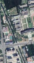
2.The aging of the city: 10 years later, the population aging of the city will become more and more serious
Architectural form:It is not the architecture that determines the landscape, but trying to adapt the architecture to the canal landscape

Details and atmosphere: the shadow of the tree on the roof-------An ambiguous border

Citizen's activities.
3.This small city has few cultural activities.
We can use one old habit to cultivate another habit. So I introduce new activities near the time period of the habitual activities, which is culturally relevant.

02
2007 1985 2016 2005 2019 2019 Square dance dog bike bike jogging chatting selling Cinema school assihnment cafe or have a meal kids school Existing activities. New activities. reading and communicating
*The data comes from the city government
20406080 Age 16% 60% 24% Drainage channel
1."Stitch" the two sides of the canal
2.link the green spaces in the communities
Urban Planning
The canal leads to the library, the museum and the gymnasium. I want to extend exhibitions, books and sports activities to the canal bank. This will provide citizens with more convenient access to cultural activities.
1.Books from the library can be passed on in various community book bars.
2.Sports activities in the gymnasium can be extended to banks of the canal.
The "stitching" method is integrated with the city's road network

"Stitching" should take into account equality for each community

03
library
library museum
museum gym
gym
Architectural Design


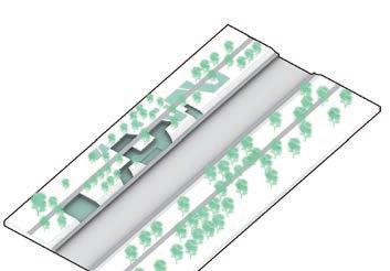


1.Steps

2.Function


The
responds

04 Activities Interior space and activities Form of space Roof Outdoor space
of architectural formation
placement Exchange and sharing (lively) Reading (quiet) Leisure & Dining Circulation space
rhythm
A.Exterior Garden B.Garden connected to the roof C.Interior courtyard D.Construction scattered in the garden B,C,D are safer places for children's
of the structure
to the space: the
roof
activities.
1.Original site view
2.Retain trees, dig down
3.Cut site with ramp route
4.Bookshelves arranged against the wall
Party or movie Party or movie Communication Communication Reading Reading Steps Relaxation Relaxation Coffee bar Coffee bar strolling Slide Platform cut off Seats Overlap
5.Add first floor:Organize Circulation the 6.Roof: The slope of the roof matches the slope of the riverbank, approximately 40%. People can climb on the roof
Architectural Design
3.Refinement of space design: combined with the original bank of the canal and retained trees


Although there is only one roof slope, there are still many forms of section: The hydrophilic platform and steps, the superposition of the roof, and the scale change of the roof create a variety of architectural spaces.


Precisely the preservation of the original trees provides more opportunities for space changes.

05
A A B B C C D D E E F F G G H H I I J J A C E F G I B D H J 8% Added trees
original bank of the canal
01020m Retained trees
Architectural Design

In this section, I try to express an intimate and embracing relationship between architecture and nature—how nature influences the form of architecture. Under this influence, architectural form still has a part of subjectivity: communication space is essential. Because communicative behavior is important for residents and cities.


The courtyard enclosed by the building can avoid the interference of traffic flow. It will provide a more quiet and safe outdoor environment for the elderly and children.
The reading space is on the side away from the canal, where it is more quiet
A safer space for children should be away from the canal,which provides a natural playground for children, an entertainment facility with slides combined with the roof.


The original road was preserved

06
People can climb on the roof, rest or chat.
Communication, interaction, lectures, and watching movies
The preserved vegetation becomes the inner garden
B C A 1-1 D
4. Section design Architecture and canals - near or far Architecture and Nature - Courtyard
A 1 1 B C D
The communication space is on the side near the canal, where the activity can be shown to people on the other side of the river, thus attracting people to join the activity.
012m
Architectural Design
5.Hand-made models and space atmosphere
These model photos show the atmosphere of the interior space: a vague and ambiguous relationship between the interior space and the nature outside.
The shadow of the tree on the roof reminds people of the comfort of reading under the tree.

07
Architectural Design


08 A B A B
6.Perspective drawings and detail design
0200mm400mm
The urban boundary The Cross of Blanquefort
STUDIO(ENSAP Bordeaux):La limite de Blanquefort


INSTRUCTOR: Prof.Laurent GOUYOU BEAUCHAMPS


l.gouyou-beauchamps@bordeaux.archi.fr
2022.3-2022.6

*The preliminary stage of this project was to team up together for site research and modeling of the entire Blanquefort. However, the design part was done independently.


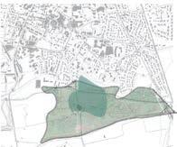
Thisproject was completed during my exchange study in France. The site is located in the small town of Blanquefort and the topic of discussion is urban boundaries. I carried out several field studies and analyzed the site thoroughly using various approaches.

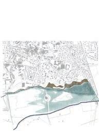
I hope to mitigate the impact of flooding by enhancing the barge of the Jalle River. As well as sharing the drainage function of the city through ecological corridors, and making the ecological structure of the whole area healthier.
The project is located in Blanquefort, a small town north of Bordeaux,south France.


Blanquefort is surrounded by nature: green fields, vineyard, pasturs and forest .
A small river named jalle runs through the pasture, causing flooding during the annual rainy season, which affects the use of the pasture and also affects the city
Moreover, Blanquefort is also a town with stories: It has a medieval fortress, a war monument, and some parks. Green space.
Artificial construction land and buildings. Water.
09
Jalle River
Jalle River
Academic project Independent work
1.PRE-ANALYSIS&PROBLEMS


IDENTIFY PROBLEMS : By investigating the flooding of the Garonne River, I found that Blanquefort was more severely affected by the flooding of its branch, the Jalle River.
PROBLEM ANALYSIS: To better analyze the drainage of the city, I used GIS and Grasshopper to analyze the terrain of the site.


Carte de l'état-major 1820-1866
Satellite imagery 1950-1965


Satellite imagery 1985
Ecologically incoherent:Urbanization of Blanquefort began in the 1960s. A town grew rapidly because of the establishment of a motor vehicle factory.The sprawling cities cut off the natural land.
Slope analysis and elevation analysis: the terrain of the town is significantly higher than that of the pasture.

the


Inundated area (rainy season) now
Inundated area (during flood) now Inundated area (during flood) 2050

Flooded area: With global warming. The problem of flooding in the site will become more and more significant, which will affect the architectural heritage as well as the farm.
2.CONCEPT
Concavity Analysis and Streamflow Analysis: Rainwater in the city collects in several "valleys" and eventually flows to the pasture.
1.Use ecological corridors to link the natural land in the north and south of the city


2.Create a buffer zone .
3. Establish a viewing platform adapted to floods.
4.The ecological corridor is below the urban ground level to facilitate drainage.
5.The line connects the different types of activities
10 N N N
pasture the pasture the pasture
"valley"
"valley" "valley" "valley" slope slope slope slope slope Jogging Circle Cultural Center Family Farm pasture
"valley"
N N N
Blanquefort Cemetery
3.Sustainable Landscape Design


Medieval fortress of Blanquefort
A slow walking path in the ecological corridor connects important landmarks of the town, such as monuments,
Pillwort
Plants that are more suitable for small animals to inhabit are added to the
Blanquefort Cemetery
Milium


War monuments
Wild flowers are planted along the waterfront because they require less
Wetlands that share the impact of flooding. Preserved original forest.
Angelica heterocarpa Acer
Family Farm (Expansion)
Fagus sylvatica
Entrance to the fortress
Garden platform
Linear pastures (avoid flooding)
Euphorbia palustris
Ecological patches that were once broken
Family farm
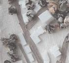
manual model
Medieval fortress of Blanquefort
Widening of the Jalle River Valley flood discharge wetland
Jonc fleuri
By adjusting the boundary form, the ecological patches are connected
Gentiana pneumonanthe
The scale of the ecological corridor is suitable for the migration and residence of small mammals, birds and insects, while livestock such as cattle live in the enclosure of the pasture
The direction of flood discharge is defined by sinking wetlands. The pastures can retain the original area and be distributed linearly on the right bank of the river where flood disasters can be avoided
*Source: Guide_Parc_des_Jalles editor: Alain Anziani Bordeaux Metropole drawing:Ziyun ZHOU





11
N
N
0400m
War monuments
A A
4.Landscape perspective view
6.Hand-made model

5.Ecological design


7.Landscape Detail Design


1.COMPACTED SUBGRADE


2.PERFORATED DRAIN PIPE

3.30 - 40 MM AGGREGATE


4.50 MM WEEP HOLE


5.NATURAL ROCK BOULDERS
6.GRAVEL BASE COURSE
NATURAL ROCK can give more convenient for small animals to climb or perch .In addition, the design of urban drainage has been taken into account too.
12 3 4 1 5 2 N
0 5m 10m A-A
water level during a flood general water level
0200mm 400mm 050m DETAIL 0510m
The
city stretches towards the boundary along urban texture.
Dharavi: Water recycling
This project was designed for the 2022 UIA competition.


INSTRUCTOR: Prof.ZOU Tianjin University 2022.10-2022.11

1.Problems: inadequate supply of running water, poor bathing facilities, and inadequate nutrition of food. The main industry in Dharavi is garbage cleaning and recycling, but the working environment is not good.

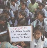


Thisproject is located in Dharavi, Mumbai, India, an area with extremely high population density and low income.For a long time, the residents have faced water supply problems. The development of real estate brokerage has caused farmers to lose their land and gather in slums. And the gap between the rich and the poor directly contributes to the disparity in food and water.In addition, the lack of infrastructure poses many sanitation problems. This project focuses on the industry of waste recycling in Dharavi, taking into account the recycling of water in daily life and garbage cleaning, and attempts to create a building that leads people to recycle water.
2.Location Analysis: Convenient access to the site provides easy transportation for waste recycling. However, the water supply stations are not evenly distributed.


3.Spatial syntax: I analyzed the accessibility and visibility of the site because of the high water activity and the need to take into account the safety of female children. To find the safest site for water activities, I overlaid multiple maps.

13
Visibility Path
Overlay
Accessibility 0 500M N 0 50100M N
Road connectivity
simulation
maps
Academic project Independent work
The cleanest water is used in shared kitchens and water stations.

Roof:The collection of rainwater.


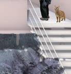


Main structure:wood from Mumbai.

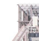
Space for children to have fun and play.
Public canteen and necessary washing space (place for socializing)
Garbage Cleaning Planting box:Slum dwellers can farm their own fields
14
Water purification
Plant Box.
0 15M30M 0 2.5M5M 0 50M100M
Xiangyu Park:Sense of belonging in public space
INSTRUCTOR: Prof.Lei ZHANG leizhang_01@tju.edu.cn 2020.9-2020.12
Site analysis


Thisproject is located in Tianjin, China. Xiangyu Park is located across from a school. Large numbers of students flock to the park every day after school, but they all just pass by. The commuter nature of the park affects people's willingness to stay. Interviews revealed that there is no sense of belonging to the park for all types of people, as the elderly, young students and office workers all pass through the site.
Therefore, I use the micro-terrain design to shield the surrounding noisy traffic and distinguish the space for passing and staying. I create small spaces for each type of people, and a large lawn as a space for shared communication. By doing so, I try to increase the sense of belonging in the park and make more people want to stay here.
The traffic around the site is noisy.
After school, a large number of students cross the site, making it unsuitable for staying
The living area around the site is fenced and relatively closed
There are some groupdeveloped activities in the community around the site. Why don't they go out in Xiangyu Park?
Functional zoning around the site


Green spaceAreas where resident activity has been observed


Form generation process:
First positioning of the "bubble", then adjusting the form, and finally the road network planning


1.Starting from a complete green area, shape the terrain


2. Identify suitable spaces for activities : considering the terrain and the surrounding area
3.Place activities from the surrounding community and the school
4.Arrange the road network :considering the terrain and try to connect the “bubbles”

5.Planting some trees: to shield the park from the noisy traffic

15 School Residential area Commercial area Offices
Sketch of the design process: Xiangyu Park before the renovation
high
Circulation low
project Independent work Studio:Community Park Design
Academic
0200M N N N 0100M 0 100m
Activity Zones:Define the activity attributes within the "bubble" in the context of the surrounding community


Vegetation zoning: considering the shielding function to the surrounding traffic


16
and elevations Traffic evacuation Crowd Gathering Area Primary road 3m Student Activities Entrance/Exit Community Events Small woodland Small woodland Lawn Lawn Flowering vegetation Brick paved square Tertiary road 0.6m Secondary road 1.5m
are
numbers of students passing through the park
Vertical design: contours
circulation:Considering the traffic flow of students after class. There
large
1.Student Activity Area 2.Children's Activity Area 3.Resident Activity Area 4.Traffic Buffer 5.Metro Entrance 6.Underground Car Park Entrance 1 1 1 3 3 3 2 3 4 4 5 6 6 N 0 200m 0 100m N 0 100m N 0 100m N 0 100m N
In the "bubble", people can only see their own neighborhoods, which gives them a sense of belonging. When one climbs onto the lawn, one can see the surrounding neighborhoods, which suggests "sharing".
enclosed spaces children's play facilities climbing paths resting spaces

Factors that can be shielded by the grass slope/terrain


Activities that can be created by the grass slope/terrain surrounding traffic noise north wind


The circulation of the Campus Life Circle and the Resident Life Circle do not interfere with each other. But they are also interconnected.
surrounding traffic


quiet street in a friendly scale
Activities could happen along the street.
noisy and polluted should be shielded(using the terrain)
The organization of circulation has two vertical lines and one horizontal line.
17
Perspective view on the lawn
Perspective view inside the bubble
Perspective view inside the bubble
This work is a group work with French students from ENSAP Bordeaux. We use organic and degradable materials to construct in the forest to express the growth of trees and the interlaced spatial relationship.


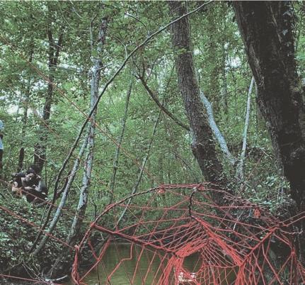
Construction work
18


