
45 minute read
Results


Renaissances
INTRODUCTION ARTICLE BY CHRIS YOUNÈS (FR) — ANTHRO-PHILOSOPHER OF INHABITED MILIEUS, PROFESSOR AT PARIS’S ÉCOLE SPÉCIALE D’ARCHITECTURE (ESA) AND MEMBER OF EUROPAN’S SCIENTIFIC COMMITTEE. FOUNDER MEMBER OF ARENA (ARCHITECTURAL RESEARCH EUROPEAN NETWORK). FOUNDER AND MEMBER OF THE GERPHAU RESEARCH LABORATORY WWW.GERPHAU.ARCHI.FR
Advertisement
AND DIDIER REBOIS (FR) — ARCHITECT, TEACHER AT PARIS’S ÉCOLE SPÉCIALE D’ARCHITECTURE (ESA). GENERAL SECRETARY OF EUROPAN AND COORDINATOR OF THE SCIENTIFIC COMMITTEE WWW.EUROPAN-EUROPE.EU
In times marked by devastation and climatic emergency, the questioning of the regenerative capacities of living milieus is at the heart of new ecologies that go beyond anthropocentrism and the nature/culture opposition. Complex, holistic and dynamic reconfigurations are asserting. In order to reanimate a biotic and ethical community, many projects tend to activate reconnections that are symbiotic (vital relationships between distinct beings) and synergistic (actions taken in concert between different elements, organs or stakeholders). Outlining such ways of being to the world implies recognising the affiliations and interactions that are at stake. A paradigm shift is underway leading to the question of how to reconcile things and beings with each other at a time when the habitability of the planet Earth is at stake. Local and translocal strategies are being associated with issues of metabolism, but also of equity and of solidarity. In the Europan 16 projects, different keys allow us to reconnect with both what we inherit and what is already there, case by case and on site. We present six particularly significant keys, between ideas and projects, that are based on the coexistence of humans and non-humans, on living with nature, on transmission and creation, on the reinstatement of scales of proximity and of continuity, on common ground through mobilisation of stakeholders, and on the start of a second life.
Idea 1: Coexistence of Humans and Non-Humans The coexistence of humans and non-human beings is all the more evident when the vulnerability of human cultures is linked to the one of biodiversity. In his magnificent novel The Overstory, Richard Powers describes how intertwined they are and how invisible they are often left: “That’s the trouble with people, their root problem. Life runs alongside them, unseen. Right here, right next. Creating the soil. Cycling water. Trading in nutrients. Making weather. Building atmosphere. Feeding and curing and sheltering more kinds of creatures than people know how to count” (Richard Powers, The Overstory, 2018).
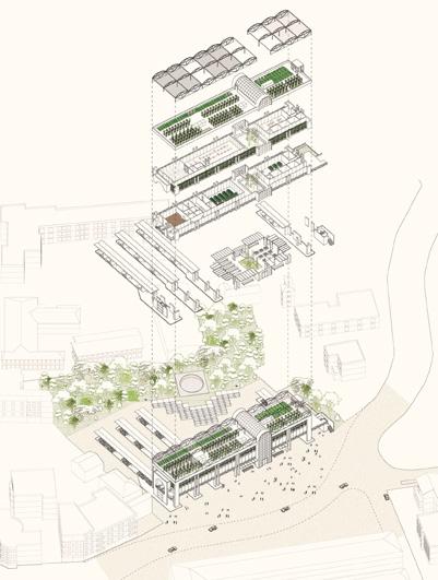
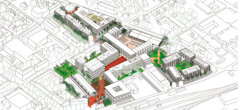
Projects — Maintain Natural Reconnections and Reinforce Biodiversity On the very large site of Fagerstrand (NO), the municipality wants to reconnect the inhabitants and their lives with nature by taking


1 — Fagerstrand (NO), winner — Living City, Living Sea > See more P.81 3 — Niort (FR), winner — Niort, Port Terrestre > See more P.191


4 — Namur (BE), runner-up — Le sol, le roseau et le cycliste > See more P.40 5 — La Porte du Hainaut (FR), runner-up — Eco-hub Raismes > See more P.55

6 — Hjertelia (NO), special mention — født i skogen> See more P.183
advantage of large ecological corridors that are rich in biodiversity. The project Living City, Living Sea (fig.1) proposes to base the urbanization on the model of a park-city structured around a green corridor and inhabited polarities, seeking a “healthy balance” between porous building ensembles and the preservation of the fauna and flora irrigating it. In Alzira (ES), where the issue is to “minimise environmental footprint through bioclimatic strategies”, the project Breezeblocks (fig.2) develops agricultural production and a circular economy in a network of existing green areas to connect the districts together and the city to the La Murta park. On the site scale, this repaired natural environment is host to a permeable and energy-efficient housing. In Niort (FR), the challenge is to “strengthen the synergy between the urban system on the conurbation scale and the local marsh agro-ecosystem”. The project Niort, Port Terrestre (fig.3) starts from a geographical and landscape analysis of the territory including the marsh to propose a PLNUi strategy —an Intercommunal Natural Development and Urbanization Plan. This strategy should let the territory develop over time by putting nature and urbanisation together in synergy. Idea 2: Living with the Forest In his book A Sand County Almanac, considered a decisive pioneering milestone in advocating an “earth ethic”, Aldo Leopold discusses the need to be part of the earth’s activity and excoriates blind productivism. He highlights the consequences of human action on the balance of what he calls the biotic community, i.e. the community of living organisms. On his Wisconsin farm near the woods, month after month, he observes and takes notes about animal behaviour, plant development and the correlations arising from good or bad
management of the fauna and flora. Throughout the Almanac, a contextualised and precise narrative presents ethical, aesthetic, scientific and practical reflections, particularly in the famous chapter entitled “Thinking Like a Mountain”. And it takes time to understand and to learn the proper use of the relations of interdependence that are established (A. Leopold, A Sand County Almanac,1949). Projects — Repairing by hybridising Architecture and Natural Evolution of the Sites In Namur (BE), the site raises the question of “How to create ecological continuities beyond the landscape ruptures?” The project Le sol, le roseau et le cycliste (fig.4) starts with a detailed analysis of the existing situation —the Regenerative capacities of wasteland of the military base has become a “shelter” for the fauna living milieus is at the heart of and flora, a rich heritage that needs to be enhanced and strengthnew ecologies that go beyond ened, and to use to connect the fragmented parts of the territory through a park. This approach the nature/culture opposition is part of the “site’s exceptional geography” and takes great care of the landscape. Some acupuncture work inserts leisure programs in the already asphalted or concreted areas in tune with the existing neighbouring facilities. On the mining site of La Porte du Hainault (FR), the project Eco-hub Raismes (fig.5) aims at fighting against the biodiversity decline and at better managing the area’s resources (soil, forest, water, industrial heritage, etc.) To do so, “reconnection with nature” is put forward through the creation of a European wildlife park with inaccessible areas to allow the redevelopment of “multiple life forms” and other, more open areas for recreation and education to nature. In Hjertelia (NO), the author of the project født i skogen (Born in the Forest) (fig.6) answers the city’s controversial request to develop new urban areas on agricultural and forest land by

7 — Pont-Aven (FR), winner — Beatmatching > See more P.153 8 — Auneuil (FR), runner-up — Continuum > See more P.224

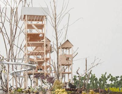
developing an explicitly critical and “situationist” response: rather than removing the existing forest, he proposes to strengthen it and make it habitable for different forms of living beings, referring to his own experience, as the project title indicates. He designs a wooden habitat that is drowned in the forest and set on stilts, allowing animals to occupy the ground while humans inhabit on the upper floors, therefore promoting their cohabitation.
Idea 3: Transmission and Creation, Tuning Rhythms The exhaustion of people and of milieus, instability and disorder are questioning our landmarks. The palimpsest of heritages and the concern for the long-term are impelling other vectors than the trap of museification. Multiple and vivid imprints and memories are revalued in order to create fruitful transversalities between the present, the past and the future. Between transmission and creation, arrangements start to articulate different spatiotemporal scales corresponding not to a priori urban forms, but to revivals and hybridisations inspired by nature and culture. Resonances are established with biological, cosmic and anthropological cycles and rhythms subject to the alternations and variations of days and nights, seasons, sunrise and sunset, tides, but also social rituals.
Projects — Regenerating with Multi-Scalar Connections and Adapting Heritage to Life Cycles and Rhythms In the project Beatmatching (fig.7) in Pont-Aven (FR), the largescale parallel territorial continuities (the Aven river and the Rue de
la Belle Angèle) act as a backbone from the existing village to the estuary. All along this axis, a partition of gardens, parks, promenades, “fragments of landscape”, and paths is emphasized, hybridizing with the preserved built space (redesigned industrial heritage of the old canneries) or with new built space (cultural “relais”, housing), forming a successful interconnection of nature and culture. This sort of open grid-pattern allows for a variety of uses (agriculture, leisure, culture, seasonal or non-seasonal housing) that vary with the natural cycles and rhythms, the seasons and social life. In Auneuil (FR), the project Continuum (fig.8) creates a landscape continuity —from the micro to the macro-scale— based on a “continuous narrative through the understanding of the preexisting built and landscape strucMoving towards a livelier city tures of the territory”. The intention is to follow the traces of the through relations that re-engage existing —a series of juxtaposed spaces— by bringing it back to life senses and meaning as close as to form a “living, non-fixed organ”. The project reinvests the strong possible to everydayness industrial heritage that has been preserved while making it evolve by inserting a new dynamic of collective and private uses. The “Colonia” in Esparreguera (ES) is a social and built heritage between rurality and industry that was reduced to two uses: industrial production and housing. The project The Ways of Sedó (fig.9) first proposes to connect the isolated entity to the city and its natural environment through a system of interconnected routes at different scales, from the valley to the neighbourhood. These routes (paths, canals, networks…) allow to reconnect with the rhythms and cycles of the natural environment, placing the district
in a circular economy (self-sufficient agricultural production) and reducing the ecological footprint. The reuse of buildings enhances the value of the heritage while integrating a “participatory model that is adjustable according to user needs”, thus crossing metabolic and inclusive approaches. In Beizama (ES), the rural metabolic dimension of the village, set in a breath-taking natural landscape, is already present in the close relationship between nature and the inhabitants. However, as the number of inhabitants is decreasing, the goal is to attract new ones. The project Ongi Etorri (fig.10) takes the decision to structure the village in a linear way, extending it along a public street. It accommodates new discontinuous “houses”, which fit into the undulating typology of the ground while connecting the linear street with the surrounding mountain landscape. They host housing, but also services and some shops on the street. In this way, this intensification of the village is anchored in the ground while reinforcing the site’s rural character.
Idea 4: Restoring Scales of Proximity and of Territorial Continuity With the Covid-19 pandemic, the potential of proximity has been increasingly recognised and treated as an art of places and connections between near and far, against the risks of withdrawal or isolation. It implies moving towards a livelier city in all its aspects through relations that re-engage senses and meaning as close as possible to everydayness —the pleasure of a walking-distance, of passing by trees, of caring for plants, of rediscovering public spaces and common areas, or of taking advantage of courtyards, balconies Projects — Creating a Close Common and Connecting it to the Territory The project Les petits ventres-villes (fig.11) in Limoges (FR) aims to repair the broken connection between the city centre and the Jacobins / Sœurs de la Rivière district; to do so, it creates pedestrian and landscape fluidity anew through voids —subtracting degraded buildings. This allows a network of public spaces to emerge, forming small centralities connected to each other until the river banks and participating in the constitution of a bio-region on a larger scale. In Risøy (NO), the city is looking for a “public space strategy” to connect the city centre to the neighbouring island, hosting the harbour and a residential district. To do so, the project Ripples in the Water (fig.12) first proposes to reconsider the large separating canal as a central recreational area, the most important public space in the city. The residential area —a juxtaposition of individual houses— evolves to compose a series of large blocks around a grid of streets forming different neighbourhoods and around common spaces, like intensity points connected by a pedestrian loop that also ensures the interface between the harbour and the city.
Idea 5: Common Grounds The search for a common ground also plays a decisive role in the opened project processes, leading to cooperation —from the design stage through the implementation and management— not

9 — Esparreguera-Colonio Sedó (ES), runner-up — The Ways of Sedó > See more P.234 11 — Limoges (FR), runner-up — Les petits ventres-villes > See more P.209


13 — Douaisis Agglo (FR), winner — The Bet of the Living > See more P.77

14 — Västerås (SE), winner — Vitality! > See more P.43
only between the architect and the client, but also including the stakeholders, i.e. the users and associations. The processes therefore include collaborative methods and principles to collect data, adjust to the specificities of situations, conflicts and divergent points of view, and co-produce meaning. Many projects explicitly aim to take advantage of these inclusive, pragmatic and democratic approaches, which are seen as valuable resources for “doing with the others”.
Projects — Involving the Inhabitants in the Ecological Transition of the Districts In Douaisis Agglo (FR) —a territory marked by coal extraction and abandoned mine shafts— the project The Bet of the Living (fig.13) aims to “reverse the extractivist memory of the exploitation of human and non-human resources” to reinforce the resilience of the inhabitants with the already-there. Based on a “vernacular” knowledge of the conurbation territory and on the commitment of the field team backed by experts, the project proposes a participative game, in which “the Action Cards for the Living” mobilize the various actors’ skills, desires and needs. The goal is to set up with the inhabitants a process of social and ecological reinvestment of the site. The city of Västerås (SE) was willing to revegetalise the industrial territory, but the answer of the project Vitality! (fig.14) goes further, adopting a metabolic approach with a multi-layered global assessment of resources over time and the identification of areas where the soil is decontaminated, fertilised and planted, and where the fjord water is purified through algae, giving life to underwater species. Between the large industry buildings still in activity and the

15 — Almendralejo (ES), winner — La increíble historia del temporero que encontró en Almendralejo su hogar > See more P.107
housing blocks, the ecological project tries to articulate a social dimension with the inhabitants’ democratic participation and to create a process of natural and inclusive coevolution around several specific intense places of proximity life.
Idea 6: Second Lives Double-sided socio-environmental rebounds can be an opportunity for metamorphosis for milieus that have reached a critical threshold. New figures enriched by reuse and recycling, mixing temporalities and mobilities, combine densities and mobilities to recreate the conditions of potential urbanities. The quality of urban life —inseparable from the way in which the composite common ground irrigates it in the forms of squares, streets and landscapes— is not a matter of quantity, but of spaces and flows punctuated by borders and passages that facilitate the fluidity of itineraries and sharing.
Projects — Reinvesting Obsolete Places through Eco-Solidary Projects In Almendralejo (ES), the challenge is to regenerate a housing area that is currently poor, run-down and far from the fields, and to integrate a community of immigrant seasonal workers into it. The project La increible historia del temporero que encontró en Almendralejo su hogar (fig.15) starts from the experience of each seasonal worker, from their arrival to their settlement, to propose the creation of a landscape of adapted green pathways. The obsolete housing area becomes a social condenser and recycles degraded buildings into diversified temporary housing and public
services. To renovate the existing buildings, a modular system with reversible use is added to the facades to make the intermediate spaces livelier (courtyards, balconies, activity areas). Roquetas de Mar (ES) is a small town built between the Mediterranean Sea and a huge agricultural plain that has become a plastic sea covering plantations and preventing the town from expanding beyond its geographical limits. The idea behind the project Second Life (fig.16) is to use a carefully catalogued legacy of colonial houses and buildings that have been abandoned after the 2008 crisis. The project aims to “give these ignored places a second life” through the revaluation of heritage and the consideration of climate change. By reusing forgotten construction methods, the goal is to foster the solidary and sustainable social integration of part of the population. In the Venice lagoon, the city of San Donà (IT) is facing climate change and natural degradation. The proposed site is a bus station —a brutalist concrete infrastructure to reinvest with a new use. Rather than simply designing spaces for commercial and communal activities, the project Agroecologic Condenser (fig.17) expands the strategic territory. An urban ecology is restored for the whole city
centre in order to make life exist in all its forms. In this context, the old station becomes a place of agricultural production. The existing vertical structure in large slabs hosts a layered diversity of plantations that contribute to the city’s goal of food self-sufficiency. In Istres (FR), the recovery of an abandoned building is taking place in a completely different context: a magnificent landscape of pine forests on the Mediterranean coast. A modular school, once an experimental project at the Regenerating milieus through time of its creation, is now obsolete and frees up a place to reconsider. The project Devising the Milieu compatible revitalizations of (fig.18) reinterprets the buildings by highlighting not their character as nature and human activities objects, but their organic dimension, made up of different modules that can accommodate various cultural programs. By creating a “pathway with an open pavilion, extending a performance hall and creating new connections through micro-passages and suspended walkways”, the architects aim at creating a “milieu”, a place to live and stay. Conclusion as a Perspective The presented projects are not models to follow, nor are they totalizing visions; they are part of a pluralist impetus on the path of transitions by regenerating milieus through compatible revitalizations of nature and human activities. This project dynamic that is visible in the Europan 16 results analysed here, could be studied further in a second session —Europan 17— on the same topic of Living Cities. It would add more emphasis on the creation of alternatives that are attentive and welcoming to differences and vulnerabilities, nourished and supported by ways of caring for inhabited milieus in a quest for meaning: by re-imagining sustainable architectures and by keeping as close as possible to what “maintains, continues and repairs”, after the three principles set out by political scientist Joan Tronto to weave together the web of life and of the world.

17 — San Donà Venezia (IT), winner — Agroecological Condenser > See more P.213 18 — Istres (FR), runner-up — Divising the Milieu > See more P.201
1.


Revitalization
Transforming Urban Ecologies
ARTICLE ANALYSIS BY MIRIAM GARCÍA GARCÍA (ES) — PHD IN ARCHITECTURE, LANDSCAPE ARCHITECT & URBAN DESIGNER. FOUNDER OF LANDLAB, BARCELONA WWW.LANDLAB.ES/EN
To regenerate the milieus is to give them life… In the Europan 16 projects, the concept of life included humans but also —and with insistence— non-human actors. The proposals all seem to be working on putting ecology, landscape, nature, whatever the name is on the plan, the section, the territory. In this very green and vivid vision of our environment, we can observe the importance of biodiversity, of the transformation of infrastructures and of the existence of intrinsic qualities of the territories to valorise. These great driving transformation forces require a reconsideration of our intervention strategies. Valuing biodiversity seems obvious in view of the objective of regenerating the environment, but transforming the infrastructure requires a paradigm shift that considers the space rather than its function. As well, this paradigm shift is required to consider the performance of the territory itself, which is a fundamentally different vision of our environment. Therefore, the projects all have in common that they support a different value system where ecology is a mediator, with a process where the relationships between the agents are reversed and the routines of making the space are questioned.
Reinforcing biodiversity was the subtopic shared by the sites of Bitonto (IT), Madrid (ES), Namur (BE) and Västerås (SE). On these sites, the impetus for the transformation comes from the territory and from the use of all the resources (natural, ecological, infrastructural) to regenerate them. Here, the driving force of change is the transformation of the urban ecology.
According to the proposals of the Europan 16 young architects the reinforcement of biodiversity can be achieved on the sites through different symbiotic relationships that will act as shapers of biodiversity. The idea is therefore about to promote a symbiotic metabolism that enhances biodiversity by reinforcing fluxes and relations and to go over the complexities of each site at multiples scales (territorial, city, local). Here, symbiotic relationships modify the physiology of the interacting “partners”, influence their ecological dynamics and evolutionary processes, alter the distribution of species, and ultimately play a role in shaping biodiversity. This strategy reminds us of the book “Symbiotic Earth”, in which renowned scientist

2 — Bitonto (IT), winner — Learning from the Lama > See more P.31
Lynn Margulis demonstrates the role of symbiosis, which simply means that members of different species live together, in physical contact, as a source of evolutionary innovation.
The project More-Than-Farming Madrid (fig.1) proposes strategies coming from the world of agriculture with a clear goal to plant a new seed in the urban fabric of Madrid. The project recognizes the scales of the territory, the temporality, the complexity of the urban substrate and the necessary actors to ensure a specific, precise, and metabolic implantation. The winning team emphasize on the idea to generate a “seedstem” applicable to the whole city where the minimum study unit is the district and not a single plot of land. The idea is to plan the management of the different districts’ environments in collaboration with other human and non-human agents and in relation to both the environment and the physical context. Different typologies of agricultural productions are designed; they are scalable and adaptable to a diversity of plots, agents, timeframes or budgets, and remain reversible, resulting into a powerful urban transformation strategy-tool. The proposal is not only site-specific, grounded in the place, but are also linked to the social fabric, ensuring its maintenance. In this sense, the proposal seems to be replicable and scalable, voluntarily avoiding rigid and serial systematization.
In Bitonto, the project Learning from the Lama (fig.2) analyses the mechanisms that regulate the territory, developing processes between the places in transformation and their reference contexts. This way, the Lama Balice (long and shallow karst furrows that cross the plain of Bari from the Murgia hills to the coastline) becomes an opportunity to merge the urban public space with the landscape and generate a positive outcome from a biological and livability point of view. The Lama Balice is a puzzle of diverse and various biotope in coexistence: uncultivated grassland, woods, Mediterranean “maquis” shrubland, caves and cliffs, agricultural polycultures, quarries, and olive and wine cultures. The idea is to have the Lama Balice penetrate the green areas inside the city in order to generate a positive outcome from a biological and livability point of view. Through a measured intervention on the land uses that accompanies the different cycles and systems, a 0-km supply chain can be developed, as well as new agricultural services and rural tourism, from the hamlets towards the centre of Bitonto. Finally, the open space of the four designed squares articulates a slope that slowly goes down from piazza Aldo Moro to piazza Castello, facing the Lama Balice and connecting with the cycle-pedestrian system and that of greenery.
In both proposals the aforementioned symbiotic approach is rooted in a holistic knowledge of the sites integrated in their territorial and local contexts, unveiling new relations between human and non-human actors through design, and ending up reinforcing biodiversity.
Overlapping systems to densify and intensify is another way of symbiotic activation, which leads to an increase in biodiversity. In fact, biological diversity is a broad concept that has been used to embody the variability among all living organisms. In this way valorising and reinforcing the multiplicity of tangible and intangible


3 — Bitonto (IT), runner-up — An Atlas of Rituals > See more P.32
site systems is a qualitative and quantitative strategy to catalyse new environments and relations. This overlapping can also be digital as in the project An Atlas of Rituals (fig.3) in Bitonto, which proposes an alternative vision connected to the digital infrastructure as an instrument of knowledge and narration of the territory. Starting from the essence of the particular moments of the olive cultivation cycle, the project generates events, activities and rituals. It proposes different levels of overlapping systems: hydrographic network trails, ecological connectivity trails between Lama Balice and Alta Murgia, circulatory trails, local production trails, and socio-cultural and heritage trails. All layers and rituals are connected and articulated through the processes of olive cultivation. Within this framework, the layers of connection become trails of rituals while the squares act as stations of these rituals. Each trail is revitalised with a catalogue of eco-spatial strategies to reinforce the connectivity. This approach reinterprets the connotations of a productive landscape; it aims to become not only a project of passive preservation and re-naturalisation, but also one of characterisation and symbiotic activation.
The project A Non-binary Ecology (fig.4) in Namur works the material between two opposite definitions such as urban/rural, soft/hard, organic/human-made and so on. The wining proposal focuses on every force and gradation that stands between the two extremes, enhancing them at all design scales to reveal and appreciate their hidden potential and to respect and identify the fertile landscapes. They are all activated on the former military site, giving space to a “Third-Landscape”, after the concept developed by French landscape architect Gilles Clément. Clément calls these fragments the Third-Landscape —the sum of all the land disturbed by human through which natural processes still occur. For the team, the loss of nature is a starting point. Different intensities are used
in the strategies of non-binary ecology throughout the plot, with extremely delicate elements at some times —small interventions that transform abandoned areas into innovative cultural devices— while at others, it is the intensity of construction that becomes a radical statement —like the Adaptive Tower, the point of maximum density. This varying intensity of actions covers the whole site, but with a recognizable coherence based on the ecological continuities and a new network of running tracks and cycle paths organized through closed rings that intertwine in a strong network of integrated slow-mobility, but also as tactical elements that punctuate the fields with a calligraphy of lines and colours. This strategy of mediation is also developed in Västerås. The former industrial site in the middle of the city shares some characteristics with the abandoned military site in Namur. Here too, an abandoned site opened the doors to natural recolonization by pioneer species; and both projects have the potential to increase —with the design— the ecological variability through mediation with the multitude of species on site. In this context, the strength of the project Landscape of Encounters (fig.5) lies in how it deals with the site to increase biodiversity. The project proposes a set of strategies collected under the categories of Vegetation & Habitats, Built Elements, Events and Reuse. The district of Mälarporten, primarily through natural processes, becomes a more sustainable place with
space for people, plants and animals. Although we have to admit that the use of the wilderness and the uncertainty can be provocative, what is interesting about the project is that by finding different symbioses with the outside of the site, the biodiversity of the built system is reinforced through different circularity processes. Also in Västerås, the project Making Space (fig.6) shares with the previous project the idea of making space for something more than us in order to reinforce biodiversity. It introduces an enigmatic motto —“Showing some Grace and Leaving Be”— that is The driving force of change complemented with a project of restoration and regeneration. In is the transformation of this way, the project proposes a large rain garden to manage, buffer the urban ecology and clean rainwater runoff. Floating gardens are also created along the waterfront as a natural filtration system to improve water quality and provide additional habitat for a diverse range of species. Finally, Making Space transforms Mälarporten into a completely new and poetic landscape where the wilderness meets the abandoned industrial landscape with installations and facilities in suitable scales. Thus, according to the proposals of the Europan 16 young architects, reinforcing biodiversity implies unveiling the diversity of value systems, of knowledge and of culture of the sites, showing curiosity towards other ways of living and designing with nature mediating relations and empowering emerging agencies and actors. It is an important step towards a multi-species city, because a living city is a diverse city, a place where natural processes, human and non-human actors intertwine in each other’s environments. A process of regenerative design that catalyses, at the same time, life, community interactions and a circular economy potentially based on nature. As we have seen, all the projects share innovative techniques that will need renewed regulations and management techniques to be implemented to work with multidisciplinary teams together with local managers.

5 — Västerås (SE), runner-up — Landscapes of Encounters > See more P.44

4 — Namur (BE), winner — A Non-binary Ecology > See more P.39
Blurred Infrastructure
ANALYSIS ARTICLE BY AGLAÉE DEGROS (BE) — ARCHITECT, TEACHER AND DIRECTOR OF THE INSTITUTE OF URBAN PLANNING AT GRAZ UNIVERSITY OF TECHNOLOGY (AT). CO-FOUNDER OF THE BRUSSELS-BASED ARTGINEERING OFFICE WWW.ARTGINEERING.EU
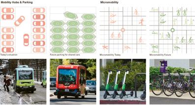
Infrastructures are an integral part of the city, they enable mobility. As mobility is changing in the face of decarbonisation, so are the infrastructures. We only need to observe the emergence of masterplans for bicycles or pedestrians, almost everywhere in Europe, or all the projects submitted in the framework of the Europan 16 competition to appreciate this phenomenon. Active mobility (pedestrians and cyclists) is taking on an increasingly important role in the modal split. Not only for ecological purpose but walking and cycling have been reinforced by the Covid19 crisis. The crisis made us rediscover the advantages of active mobility and enabled the setting up of temporary installations during the various lockdowns, which have become permanent, as is currently happening in Berlin, Paris and Milano. Moreover, with the re-discovery of our immediate surroundings during the lockdown —“suddenly we were no longer from everywhere but from somewhere”—, it seems that the competitors have discovered the profusion of infrastructures around themselves. With the separation of functions during the modernity —production, work, leisure, residence…— the number of infrastructures has significantly increased as a consequence of zoning planning. If you do not work where you live, if you do not spend your free time where you reside, if you do not produce where you consume, you or the goods have to move and therefore, you need infrastructure. One could sometimes consider infrastructure as a kind of collateral damage of modern planning and specifically question its actual necessity, or at least part of it. This is why there is more and more talk of infrastructure obsolescence. Of course, in the submitted projects, we can observe that not all infrastructures are obsolete, but the space dedicated to traffic can nevertheless be optimised and allow for other uses. It is not the whole infrastructure space that is transformed, but part of it. These transformations, whether they concern obsolete infrastructures or those in activity, remind us that infrastructures are also public spaces, even if we have sometimes forgotten it, as they are so much taken over by traffic engineering. Infrastructures therefore play a dual role in urban transformation. Their revitalisation allows the transition to new forms of more sustainable mobility while their obsolescence or the optimisation of the space dedicated to traffic allows the reconquest of public space.


3 — Varberg (SE), special mention — Lifeline > See more P.65

4 — Klagenfurt (AT), runner-up — Tracing Domains > See more P.50
5 — Varberg (SE), runner-up – Trädlycke, a New Centre > See more P.64
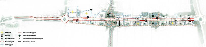
Active Mobility and Revitalisation The sites of Risøy (NO), Varberg (SE) and Klagenfurt (AT) are strongly marked by the transformation of mobility. In Risøy it involves the construction of a pedestrian bridge linking the island and the town centre. In Varberg a new regional railway station allows the transformation of the 2.6km-long road that crosses the site. In Klagenfurt, the construction of a tunnel will allow the city to be much more accessible by train and the station will consequently be much more attractive. In this context, the proposals use this mobility shift and benefit from it to revitalise the space. The Ripples in the Water project proposed in Risøy restructures the circulation according to the inspiration of the superblock. A hierarchy is introduced in the road network in order to transform the streets in the heart of the superblock into an axis dedicated to active mobility, while the surrounding street are dedicated to public traffic (fig.1). It is also a transformation of the organisation of mobility that allows the revitalisation of the site of Varberg. In the project Make the Backs Fronts (Again)!, a so-called smart mobility is proposed. Mobility hubs, among other things, punctuate the main street, reducing individual traffic by proposing alternative ways of vehicles mutualisation (fig.2). With the Lifeline project submitted on the same site, different principles to encourage active mobility are implemented with a multiplication of routes for pedestrians but also principles of prioritisation of active mobility above other kind of mobilities, for example at crossings (fig.3). For the area close to the Klagenfurt station, the focus is on active mobility as the first or “last mile” to the station. The Tracing Domains project even proposes the construction of a footbridge over the railway tracks to extend pedestrian accessibility to the area on the other side of the tracks (fig.4). These projects improve the mobility offer based on individual movement, which does not rely on private car ownership. This includes pedestrian mobility and all types of cycling mobility, but also car-sharing systems. Because of the limited space taken by these forms of mobility, these developments reduce the footprint of mobility in the urban fabric. Moreover, because of the more limited range of action compared to motorised mobility, active mobility creates a different urban network based on proximity. In these projects, a number of proximity amenities are developed, such as the 15-minute city. The underlying idea of the 15-minute city aims at a decentralised urban structure. According to this idea, each neighbourhood is equipped with local suppliers, doctors, open spaces and recreation areas, sports facilities, shared offices, schools, day-care centres, etc. This makes it possible to access all the functions of daily needs within a quarter of an hour on foot or by bicycle from anywhere in the city. This is exactly what is proposed in the project Trädlycke, a New Centre for the Varberg site, where a new centre with various local functions is developed in relation with new mobility (fig.5).
7 — La Porte du Hainaut (FR), winner — Short Stories from the Fragmented City > See more P.53

6 — Risøy (NO), winner — Ripples in the Water > See more P.57
Obsolescence and Revitalisation The sites of Risøy (NO) and La Porte du Hainaut (FR) are made up of numerous road and rail infrastructures, not all of which are necessarily functional. In Risøy, there is an abundance of asphalt, roads and landing docks. In La Porte du Hainaut, the infrastructure is linked to the former mine industry, including the railway network linked to the transportation of coal, in this case the infrastructure is rather linked to the transportation of goods than people. In Risøy, the project Ripples in the Water proposes that the street and the asphalt inside the block become a green corridor with pavement, flowery meadow and orchard mix. This space revitalizes the district with its ecological character mixing water storage, infiltration and biodiversity, but also by providing a collective neighbourhood space (fig.6). A slightly different approach is envisaged for La Porte du Hainaut. It is a set of various elements, some of which are obsolete, such as the numerous stations linked to mining, which is the basis of the project Short Stories from the Fragmented City. The project develops loops linked to these infrastructures, without falling into nostalgia, the loops being connected to small centralities with facilities developed around the stops of the metropolitan tramway. These proposals echo the Coulée Verte in Paris or the Highline in New York, which have been milestones in the transformation of
obsolete traffic spaces. They demonstrate the potential that the transformation of an infrastructure can have for a neighbourhood or even an entire city: the Highline has become not only a popular space for people living and working nearby, but also one of the most visited tourist attractions in New York (fig.7). In this sense, the Eco-hub Raimes project makes the infrastructure disappear under its rewilding. In this proposal, the notion of obsolescence is not limited to the infrastructure, it is a whole territory that becomes obsolete (fig.8). Optimisation and Revitalisation The sites of Risøy (NO) and Klagenfurt (AT) require infrastructure, in this case no obsolete infrastructure, as they are nodes of mobility for the ferry landing in Risøy, and for the proximity of the railway station in Klagenfurt. The Third Space project in Risøy reconnects the different fragments of the site: “the infrastructure that was once conceived to connect functions has in many places changed into a barrier both spatially and socially”. In this sense the strategic placement of a new bridge for active mobility creates a new loop with the centre of Haugesund, transforming the car park where the pedestrian bridge landed into a square articulating the island and the coast. The infrastructural space dedicated to the car becomes a real public space (fig.9). In Klagenfurt, the 5 Square of New Learning project proposes that “An enfilade of public spaces create the main circulation route and form a spine of public space (fig.10). It will connect all the site’s The space dedicated to areas with the historical centre and the main railway station”. traffic can be optimised The interstitial spaces (between buildings) normally monopolised and allow for other uses and designed for mobility are not considered as residual spaces but rather as structuring spaces. This is an interpretation of the infrastructure not as functional but as spatial, i.e. as a sequence of spaces where one strolls more than a corridor solely dedicated to passage. These proposals, while maintaining the infrastructure, reduce the space dedicated to traffic, as did Lola Domenech’s famous transformation of Barcelona’s Passeig de Sant Joan (ES). The pavements of the wide urban boulevard, previously mainly dedicated to car traffic, have been widened and used to accommodate new
planting and recreational spaces. A cycle path was laid out in the middle of the road and the width of the lanes reserved for individual motorised transport was reduced to a minimum. Here, the norms and rules that favour the flow of car traffic have not only been challenged, they have been circumvented. In the Tracing Domains project in Klagenfurt, a similar principle is deployed: the interstitial space articulates the built environment, but this time, in a linear way. The typology used is the one of green boulevards and alleys, it is a space where one can linger; it is not a traffic corridor but a constructed and staged space (fig.11). This project questions the way of making the city and of constructing the urban texture when the idea of traffic no longer dominates the organisation of the urban texture.
We could learn from the different projects proposed that the revitalisation through infrastructures offers an organisation of the urban texture that is not dominated by the infrastructures, which blur into the territory giving birth to a city of proximity. This is obviously a huge paradigm shift in urban design, the interstitial space is structuring but is no longer necessarily an infrastructure, it becomes a space in its own right. This change challenges many planning and urban design routines. For the moment it seems that the routines of modernity are unshakeable… even though they have replaced other secular routines. The challenge for the projects mentioned is to prove, through their implementation, that it is possible to leave the routines of modernity behind us.

8 — La Porte du Hainaut (FR), runner-up — Eco-hub Raismes > See more P.55
11 — Klagenfurt (AT), runner-up — Tracing Domains > See more P.50

9 — Risøy (NO), winner — The Third Space > See more P.58
Activating Territories as Actors of the Project
ANALYSIS ARTICLE BY CARLOS ARROYO ZAPATERO (ES) — ARCHITECT, URBANIST, LINGUIST, TEACHER IN MADRID’S UNIVERSIDAD EUROPEA. FOUNDER AND DIRECTOR OF CARLOS ARROYO ARQUITECTOS WWW.CARLOSARROYO.NET
Our growing understanding of the delicate balances in our ecosystems has led to the acknowledgement of complex networks and interactions at the territorial scale where each agent can and will influence the rest. This has demanded an approach to design that leaves room for those other agents to develop, mutate, or simply gain agency. In this pursuit, we no longer design objects in space, nor linear elements of infrastructure; we arrange for potentials to develop, for events to be triggered, for conditions to emerge, and for the territories where we operate to become the agents of the design. The proposals in this group blur the limits between the traditional roles of subject (user), object (constructions) and designer (architect) in a context (space), resulting in a continuum where users may be designers, or the context may be the subject. When intervening in a territory with the prospect of revitalization, we may not require an injection of external agents, but find the elements in the territory itself. Such is the case on the sites in this set, where the agency of the territory may be given the opportunity to reconnect to the social context and develop its own creative and cultural qualities. Proposals in this group do not focus on spatial formal entities as such, but on the actions and events that they may trigger, particularly those that may be performed by the territory itself, heralding an urbanism of natural cycles. This approach requires the development of a new language, a kind of script that allows for the territory to perform its own role in the theatre of the world —a language we shall try to identify in each of the works in this session.
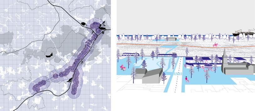
The Stage as a Performing Character In a first subset, we may look at proposals where territorial ecosystems can be the agents to facilitate the socio-economic revitalization of urban areas, which are no longer seen as separate entities. In Fagerstrand (NO) the winning proposal, Living City, Living Sea, shows a relationship between the city and the sea that is very far
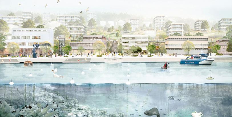

2 — Fagerstrand (NO), winner — Living City, Living Sea > See more P.81 3 — Fagerstrand (NO), runner-up — One Upon a Time in Forestrand > See more P.82

4 — Fagerstrand (NO), runner-up — One Upon a Time in Forestrand > See more P.82
from the “waterfront” concepts of the past. Rather than portraying the ocean as something to look at from a waterfront café, they offer the rare view of a section of the fjord, giving half the stage to the bottom of the sea and the creatures that may develop in the healthy environment they intend to regenerate (fig.1). The program is also centred on the water, the management of rainwater, a circular water system for human use, and productive strategies using hydroponics and fish farming (fig.2). It is an extreme take on the idea of blue infrastructure, that permeates the whole design, accompanied by green infrastructure. Blue and green form a network that provides the base for human activity, including mobility —as cars are relegated to a peripheral role. The runner-up in Fagerstrand (NO), Once Upon a Time in Forestrand, in contrast, looks at the forest, and not at the sea, as a main character in the plot (fig.3). The role given to the already existing forest is defined as a fourth landscape, a synchronization of the three classical natures (first, wilderness; second, agricultural and urban; third, gardens and parks) to create a fourth, an inhabited natural system. In their graphics, the forest speaks with the speech-bubbles that are typical of comic strips (fig.4). The project embraces its fictional nature from the title and with its motto: Form follows fiction. The forest redefines our relationship with it through storytelling and performance. The title of the winning proposal in Bassens/Bordeaux Métropole (FR) is explicit in this symbiotic approach that aims to trigger the emergence of renovated energies: Symbiotic BOOM! They propose a hybrid model where the regeneration of the port area is driven simultaneously by three strategies: renaturalization, circular economy and collaborative resource-management. The ecological, the productive and the social are physically intertwined, with devices like the “life stripes” that deal with the biotic elements of the context with an infrastructural approach, in parallel to mobility
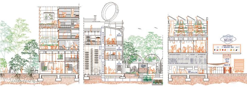
5 — Bassens / Bordeaux Métropole (FR), winner — Symbiotic Boom! > See more P.73
6 — Wernigerode (DE), runner-up — United Gardens of Wernigerode > See more P.89 7 — Wernigerode (DE), winner — Duet > See more P.87


infrastructure, and providing opportunities for social interaction (fig.5). The graphics are equally intertwined, charting the program for phased action with text in three colours, that are also reflected in the drawings, visualizing the balanced importance of the three in pan and section.
A Chorus of Landscapes The sea or the forest can be strong characters in the play, the heroes, but in other contexts the action may be carried by a collection of characters to develop a choral design. Such is the approach exemplified by the runner-up proposal in Wernigerode (DE), United Gardens of Wernigerode, where the main points in the program consist of a series of interventions in open spaces, in gardens that are linked together by lifting fences and opening gates while keeping their individual characters. Soft mobility, community building, circular economy, soft dwelling, intergenerational living, different functions are addressed by means of garden interventions, where huts and soft constructions integrate into a home-grown chorus of connected landscapes (fig.6). All the documents share a subtle graphic code by which softer actions and agents (workshops, plants, furniture) are shown in brown, and harder elements (buildings, infrastructure) are drawn in sharp blue lines. The old plot divisions are therefore drawn in hard blue, but they are cancelled by the huts and activities that create the new link, in soft brown. The winning proposal Duet, on the other hand, radically erases the old plot lines by overlaying thin strips of public property, as if correcting a drawing with Tipp-ex tape or with Photoshop’s healing
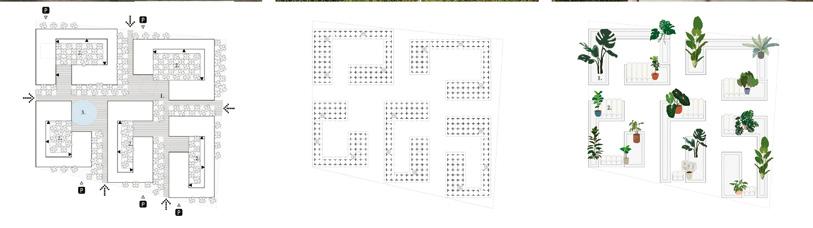
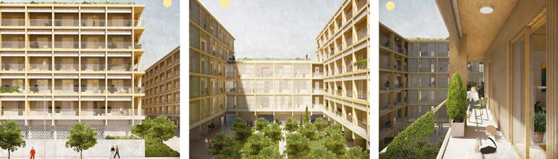
tool. This transforms the houses-on-a-plot-each scheme into a houses-in-a-shared-park arrangement, where the former fences become pathways amongst a variety of gardens, all animated by self-built civic devices (fig.7). In Alzira (ES), a location with a much higher density, the winning project, Orangerie, proposes an equivalent approach by linking together several spaces that would be perceived as internal courtyards in a classical enclosed-block urban morphology. Each inner courtyard is a plantation of orange trees and other aromatic species; the courtyards are open on one corner and linked to the others at that point to form a continuous promenade on the edge of the blocks (fig.8). The chorus of hortus in-conclusus orange groves finds a counterpoint on the Users may be designers; the galleries and on the roofs, where garden roofs are articulated from context may be the subject a greenhouse on the edge of the opening of each block, providing social as well as productive functions. This punctuated choir of greenery is referenced on a strict partiture, a perfectly abstract pentagram of structural lines. The Improvised Play The rediscovered agency of the landscape calls for a scriptwriting technique that may allow for uncertainties in the territorial decision-making process. This is particularly true if the ultimate aim of a project is renaturalization, as is the case in the runner-up proposal in Alzira (ES), Breezeblocks. The very idea of rewilding implies losing control as designers, it requires us to let the territory (and the population) take control of the decision-making process. The timeline for this
is long, as it is important to set the conditions for the natural cycles (and the circular economies) to be self-sufficient. In this context, the breezeblocks in the title are modular elements that can be used flexibly, like Lego pieces, large or small. This is the narrative proposed by the team, to allow for a phased implementation that is able to take change and improvise new arrangements. They also describe an equivalently flexible piece of landscape, the green vector, that can be introduced in the urban tissue to prepare the soil for a freer evolution in the future. The resulting imagery is a combination of agriculture, biotic and non-biotic productive activity, combined with flexible housing (fig.9). In the winning proposal for Douaisis Agglo (FR), The Bet of the Living: Rethinking (Ourselves) Together, a series of actions are imagined, to be discussed and decided upon in a Latourian parliament of things, including the opinion of humans and non-humans. The documents include a range of options, instructions for debate, imagery to be proposed, all designed and written with the intention to reach the general public, as well as to interrogate the non-human agents of the territory. The third panel is a simulation of events, and as such the drawing technique changes, adopting a non-expert style recalling children’s drawings, very far from the stylized drawings in the first panel (fig.10). This reads as a very conscious reminder of the fact that some kind of pidgin language Conclusions Over the successive sessions of Europan we can identify a growing set of tools being developed to work with time. Participants increasingly consider the journey as destination, the process as the project. This is particularly important in territorial scales, where long-term design thinking is called for, where initial designs can only be visualized as a simulation of events. On the other hand, the initial actions proposed by the teams in this scale are very far from the territorial actions of the past, which could be caricaturised as a combination of automobile and transport infrastructure around which to colour-paint a zoning plan. Teams are proposing alternative actions, such as water harvesting infrastructure or pathways in the forest as a way to activate the hidden values of the territory and reconnect them to the community. Young architects are interrogating territories to understand what these can do, rather than engaging in form-finding exercises. Young architects are intent in making territories performative.
8 — Alzira (ES), winner —Orangerie > See more P.69

9 — Alzira (ES), special mention — Breezeblocks > See more P.70


