3 minute read
Guest column – Phil Duncan
from Dairy Farmer December 2022
by AgriHQ
By Phil Duncan
After La Niña fades, is El Niño next?
The team at Weather Watch crunch the data to see what farmers may have in store for the summer growing and harvesting season.
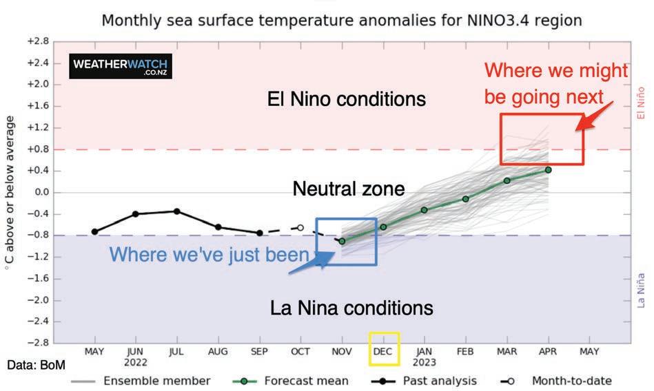
Our third La Niña in a row is still with us – but 2023 looks to be different with neutral conditions returning, and even some chatter about El Niño. So what is the set-up for summer and beyond?
Firstly, our third consecutive La Niña remains but isn’t very powerful. It peaked in November (not that you may have noticed) and is expected to gradually fade away over summer. La Niña means sea surface conditions north of New Zealand are warmer than average (they are warmer than average around most of NZ too, but that isn’t due to La Niña).
This encourages more low pressure to our north and that simple formula or low pressure north of NZ and more high pressure over southern NZ creates an “easterly flow” in the north. This is why some popular camping grounds and holiday spots in the east aren’t always super flash in a La Niña summer (this is coming from experience of tents being ripped during our family summer holidays in Hahei, Coromandel Peninsula).
The tropical cyclone risk in NZ is usually the same each year – we generally have the risk of being impacted by two or three ex-tropical cyclones. Sometimes they head to NZ but track just off to our east so we entirely miss them (and all their rain).
At other times NZ acts like pins in a bowling alley and that cyclone just rolls straight in for a strike. It’s really luck of the draw – or by that measure, luck of the high-pressure zones that actually guide cyclones.
Cyclones behave like rivers on land – they go for the path of least resistance. Cyclones avoid high pressure zones (the hills in the atmosphere) and track around them and between them. If they run into one the cyclone usually falls apart, or, as New Zealanders say, becomes “a fizzer”.
With La Niña fading over summer, it still actually adds a little more oomph to that tropical cyclone risk – but doesn’t necessarily make that path to NZ any easier. It will still be down to the large high pressure zones in our part of the world.
So what happens in 2023? Keep in mind that during peak La Niña in spring, NZ was still frequently being dominated by weather patterns out of Australia, the Tasman Sea and the Southern Ocean (very much NOT La Niña!). So the often chaotic weather pattern driven by the Southern Ocean may still impact us.
Neutral (that is, no La Niña or El Niño) is generally good for NZ as it creates more variety and chaos – that’s usually good in the world of animals and pasture as you get a healthier mix of rain, warmth and sun rather than just one of those, which can fast lead to flooding or drought. Chaos and variety are good.
El Niño
Firstly, it should be noted that no one is locking in El Niño. But the “model of all models” (which places the most reliable climate and weather global models side by side) shows our Pacific climate strongly heading back to neutral in 2023 – and perhaps even continuing on to El Niño, the opposite of La Niña.
El Niño is when warm sea surface waters at the equator get blown more towards South America – which cools the sea north of NZ and encourages more high-pressure zones in the Tasman Sea.
The result for NZ? Drier, windier west to southwest winds, more cloud in the west and a higher chance of drought and heat in the east and north of both islands.
The last El Niño was in 2018/19 but it was mild. The last major El Niño was 2014/16 and prior to that 1997-98. So be prepared for dry conditions in 2023 – but remain optimistic that NZ’s location on Earth means no long range forecast is ever set in concrete. n


