
4 minute read
Interior establece las señales que informarán a la población ante maremotos


FMHOY - Fuerteventura
La Dirección General de Protección Civil y Emergencias del Ministerio del Interior ha editado una guía técnica con el sistema de señalización que deberán utilizar las Administraciones Públicas de nuestro país para avisar a la población sobre las rutas seguras de evacuación en caso de maremoto. La necesidad de establecer un sistema de señalización común es una de las primeras iniciativas adoptadas para la implantación del Plan Estatal de Maremotos aprobado en 2021.
Advertisement
El Plan de Señalización desarrollado para el Sistema Nacional de Protección Civil sigue el modelo contenido competente en cada territorio y deberá aparecer en las lenguas oficiales de cada Comunidad, además de recomendarse la utilización de una versión en inglés o en cualquier otro idioma mayoritario entre la población residente.
Además, el Plan de Señalización establece una serie de criterios que deberán tener en cuenta las Administraciones Públicas para su implantación como su ubicación más adecuada, una óptima visibilidad y buena accesibilidad.
El riesgo de maremotos en España señalización común es una de las primeras iniciativas adoptadas para su implantación. La planificación ante este riesgo se complementa con los Planes que aprueban las Comunidades Autónomas y los Ayuntamientos.
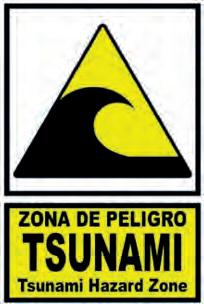
Sistemas de alertas en la norma UNE-EN ISO 7010:2020, el más utilizado internacionalmente, con el objetivo de que los ciudadanos de cualquier país puedan identificar fácilmente las vías de evacuación y las zonas seguras.
El Plan Estatal de Protección Civil ante el Riesgo de Maremotos, que se integra en el Plan Estatal General de Emergencias de Protección Civil (PLEGEM), crea un sistema de anticipación y alerta temprana que permite avisar de la inminencia de este tipo de emergencias tanto a las autoridades de protección civil y a los servicios públicos de emergencia como a los ciudadanos para que puedan poner en práctica protocolos de autoprotección, con especial atención a las personas más vulnerables.
Esta guía técnica de información a la población, que cuenta con el informe favorable del Consejo Nacional de Protección Civil, establece una señalización homogénea para todo el territorio nacional.
Su implantación correrá a cargo de la Administración
Todo el litoral español está expuesto al riesgo de maremotos, pero especialmente vulnerables son las comunidades de Andalucía, Canarias, Cataluña, Comunidad Valenciana, Galicia, Islas Baleares, Región de Murcia, Ceuta y Melilla. Estas Comunidades y Ciudades Autónomas suman un total de 6.846 km de costa, el 86,49% de los 7.905 km totales.
España dispone de un Plan Estatal de Maremotos desde mayo de 2021 y el desarrollo de este sistema de
El Sistema Nacional de Alerta por Maremotos (SINAM) es un sistema único y coordinado capaz de detectar precozmente la generación de maremotos que puedan afectar a las costas españolas y transmitir, en el tiempo más corto posible, la información a los órganos competentes en materia de Protección Civil de los ámbitos territoriales potencialmente afectados. El SINAM se nutre de la información recopilada por la Red Sísmica Nacional; la red de mareógrafos REDMAR de Puertos del Estado; los sistemas de detección del Instituto Español de Oceanografía, así como los demás sistemas de detección marina de las distintas administraciones públicas y de otros centros internacionales.
Además, en la actualidad también puede ser utilizado el sistema de alertas a dispositivos móviles, ES-Alert, mediante el cual los Centros de Emergencia del Estado y de las Comunidades Autónomas pueden enviar mensajes de alerta en situaciones graves directamente a los teléfonos móviles que se encuentren en las áreas previamente identificadas.
Establishment of signals to inform the population in case of tidal waves
FMHOY - Fuerteventura
The General Department for Civil Protection and Emergencies of the Ministry of the Interior has edited a technical guide with safety signposting to be used by the Public Administrations of Spain to inform the population of the safe evacuation routes in case of a tidal wave. The requirement to establish a common system of signposting is one of the first initiatives adopted for the implantation of the Tidal Wave State Plan, approved, in 2021.
The Signposting Plan developed by the National System of Civil Protection follows the model contained in the UNE-EN ISO 7010:2020 regulation, the most widely used internationally, that aims for all citizens from any country to be able to identify easily evacuation routes and safe zones.
This technical guide of information for the population,which has been approved by the National Council of Civil Protection, establishes a uniform signposting for the whole national territory.
It will be implemented by the competent administration in each territory and will appear in the official language of each Community, and a version in English or any other language spoken by the majority of the resident population is recommended.
Furthermore, the Signalisation Plan includes a series of criteria that should be taken into account by Public Administrations such as the most adequate location, optimal visibility and good accessibility.
The tidal wave risk in Spain
All of the Spanish coastsare exposed to tidal wave risks, but more particularly in the communities of Andalusia, the Canary Islands, Catalonia, the Community of Valencia, Galicia, the Balearic Islands, the Area of Murcia and Ceuta y Melilla. Those Autonomous Communities and Towns represent a total of 6846 kilometres of coasts, which is 86,49% of the 7905-kilometre total.
Spain has had a Tidal Wave State Plan since 2021, and the development of that common signalisation system is one of the first initiatives adopted for its implantation. The planning for this risk is complemented by Plans approved by the Autonomous Communities and the Ayuntamientos.
Alert systems
The State Plan of Civil Protection against the Tidal Wave Risk, which is integrated within the General State Plan of Emergencies of Civil Protection (PLEGEM), creates a system of anticipation and early alert that warns the civil protection authorities and public emergency services, as well as the population, of the imminence of this type of emergency, so that the self-protection protocols can be applied, with special attention for the most vulnerable people.
The National System of Tidal Wave Alert (SINAM) is a unique system which is able to detect in advance the creation of tidal waves that can affect the Spanish coasts and transmit, as fast as possible, the information to the competent organs in the Civil Protection of the affected areas.
The SINAM gathers information that is put together by the National Seismic Network, the REDMAR Tide gauge network of the State harbours, the detection systems of the Spanish Institute of Oceanography, as well as the other systems of marine detection of various public administrations and other international centres. Furthermore, at present, the alert system can be used with mobile devices, ES-Alert, through which the State and Autonomous Community Emergency Centres can send alert messages, in case of serious situations, direct to the mobile telephones that are located in the areas previously identified.


