PORTFOLIO
Gareth Ringrose | MA Urban Design

1/31 Hazel Street, Como, Western Australia, 6151 0478 943 281
• ringrg01@gmail.com
https://www.linkedin.com/in/garethringrose-498307a3/
Gareth Ringrose MA Urban Design
My name is Gareth Ringrose. I am an experienced, organised, hard-working, collaborative, and creative Urban Designer seeking a new opportunity since returning home to Perth after more than seven years abroad.

In that time, I was employed by Barton Willmore now Stantec, an industry-leading planning and design company based in the UK, where I progressed my role from Professional to Associate level, working within a talented team of 10-15 urban designers and alongside an extensive multi-disciplinary network of other professionals. I have worked on a wide variety of complex and challenging projects across the UK, predominantly involving the promotion and delivery of residential and mixed-use developments for national housebuilder clients. Since leaving the UK in October, I have continued my role remotely on a short term basis.
Throughout my experience, I have developed a comprehensive knowledge of urban design principles, planning frameworks, project management, supporting software, and industry trends. I am able to develop clear and creative strategies for all project types that consider the client’s objectives, team working, and programming. I am confident in communicating my ideas, leading discussions, and giving clear and well-rounded presentations. I enjoy collaborating and understand the value of team working in building relationships and developing creative solutions. And I am a very respectful person and actively encourage supportive environments through always being positive, attentive, and caring.
I am seeking a new opportunity to share my experience and continue my development within an enthusiastic team environment.
CONTENTS © This document includes content that is copyright to Barton Willmore Design Ltd. This document and its contents are not to be shared without the written consent of the author. February 2023. 1 Land West of Houghton Barton 8 2 Wixams East 10 3 Victoria St Vision 12 4 Temple Border 14 5 Pickedmoor 18 6 Lower Bullingham 22 7 Abson Road 26 8 Cribbs Causeway 30 9 Minsmere Road 34 10 Treasbeare Garden Village 36 11 Newbridge Point 40 12 Other Works 44
Education Experience
Master of Urban Design
Australian Urban Design Research Centre
(University of Western Australia)
Perth, Western Australia, Australia
2013 - 2014
Bachelor Of Arts (Communications)
University of Western Australia
Perth, Western Australia, Australia
2007 - 2011
Soccer Scholarship / Exchange
Cardinal Stritch University
Milwaukee, Wisconsin, USA
2009 - 2010
Urban Design Associate | Apr 2022 - Present
Barton Willmore now Stantec | Bristol, United Kingdom
• Supporting / Lead role on complex and challenging projects, predominantly involving the promotion and delivery of residential and mixed-use developments for national housebuilder clients.
• Comprehensive site, context, and character appraisals to inform design proposals.
• Development of exciting and deliverable design concepts that demonstrate a clear design rationale.
• Production of supporting conceptual drawings, masterplans, and other detailed illustrations.
• Production of documentation comprising strong written and graphic outputs.
• Project management including day-to-day job running; liaising with colleagues, consultants, and clients; delegating tasks; mentoring junior team members; working to deadlines; and finance administration.
• Engagement with local communities and other stakeholders through collaborative design workshops and public exhibition events.
• Build strong relationships with clients through attentive, reliable, and first class service.
• Support the generation of new client work, through networking opportunities and development of business development skills.
• Contribute to the design process through thoughtful commentary and sound technical knowledge.
4
CV
MA Thesis
• Foster a supportive and encouraging working environment through always being respectful, attentive, and caring.
• High proficiency in Adobe Suite (including Illustrator, InDesign, and Photoshop), AutoCAD, and Microsoft Office.
• Excellent team working skills, with the ability to confidently communicate ideas, lead discussions, and develop clear consensus.
• Strong organisational skills and careful attention to detail.
• Keenly involved in improving the way we work through knowledge sharing and training.
• Keenly involved in office social groups, including organising team study trips.
• Basic knowledge of business finance management, including budgets, fee projections, etc.
• Mentor to an Urban Design Graduate.
• Development of clear and creative strategies for all project types that consider the client’s objectives, feasibility, context, involvement, and approach.
• Effective communication skills to motivate colleagues, bring solutions, and drive change.
• Close working with an extensive multi-disciplinary network of other professionals.
• Resourceful understanding of industry trends shaping the future of urban design and how they can be incorporated into project work.
• General understanding of current planning frameworks and how they impact and effect the design process.
Senior Urban Designer | Oct 2018 - Mar 2022
Barton Willmore now Stantec | Bristol, United Kingdom
Urban Designer | Apr 2015 - Sep 2018
Barton Willmore now Stantec | Bristol, United Kingdom
Urban Design Intern | Feb 2015 - Mar 2015
Hatch RobertsDay | Perth, Western Australia
‘In this century, sea level rise threatens to flood Fremantle’s historic core. How should its urban form strategise against this problem?’
This research project was presented for the degree of Master of Urban Design at the Australian Urban Design Research Centre (AUDRC) (University of Western Australia) in 2014.
https://issuu.com/garethringrose/docs/urbd_thesis_gr__2014_hr
The project received a Distinction grade and was also presented within ‘Excursions in DensityCase Studies for Densifying Perth’ (2016), a publication by AUDRC.
5
References
Alex Trott | Urban Design Director
Barton Willmore now Stantec | Bristol, United Kingdom
Alex.Trott@bartonwillmore.co.uk
Barry Williams | Urban Design Director
Barton Willmore now Stantec | Bristol, United Kingdom
Barry.Williams@bartonwillmore.co.uk
James deHavilland | Masterplanning Director
Barton Willmore now Stantec | Bristol, United Kingdom
James.deHavilland@bartonwillmore.co.uk
This portfolio presents a collection of works from my experience as an Urban Designer.
The works presented showcase my involvement in a wide variety of projects, a comprehensive knowledge of urban design principles, and graphic outputs that have great impact with clear purpose.
6
LAND WEST OF HOUGHTON BARTON
Devon, UK | Site Promotion
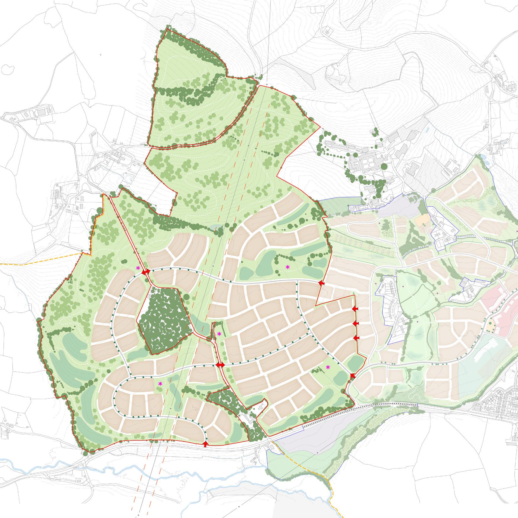
Land West of Houghton Barton lies to the west of an existing allocation for mixed-use development, which is in control of the same national housebuilder client. The Site presents an opportunity for future growth that would provide approximately 1,450 new homes with supporting facilities and services, generous public open spaces, and an extensive blue and green infrastructure network.
8
01
Land West of Houghton Barton Concept Plan
Working with a team of consultants, a short document was prepared on behalf of the client to support the Site’s promotion, with a focus on presenting a clear vision that endorsed the principles and priorities of the local authority, and demonstrating the strategic opportunity and technical viability of the Site for development.
Land West of Houghton Barton comprises approximately 110ha of mainly agricultural land, forming large fields with planted boundaries.
The Concept Plan illustrates an emerging spatial framework that has largely been shaped by the distinctive landform character of the Site and its relationship to the existing allocation, which seeks to form a coherent settlement edge to the west of the town.
A key feature of the design was to create a network of connective green spaces, acting both as ecological corridors (including function as bat transect routes) and sustainable movement routes to soften and assimilate the development into the landscape.
9
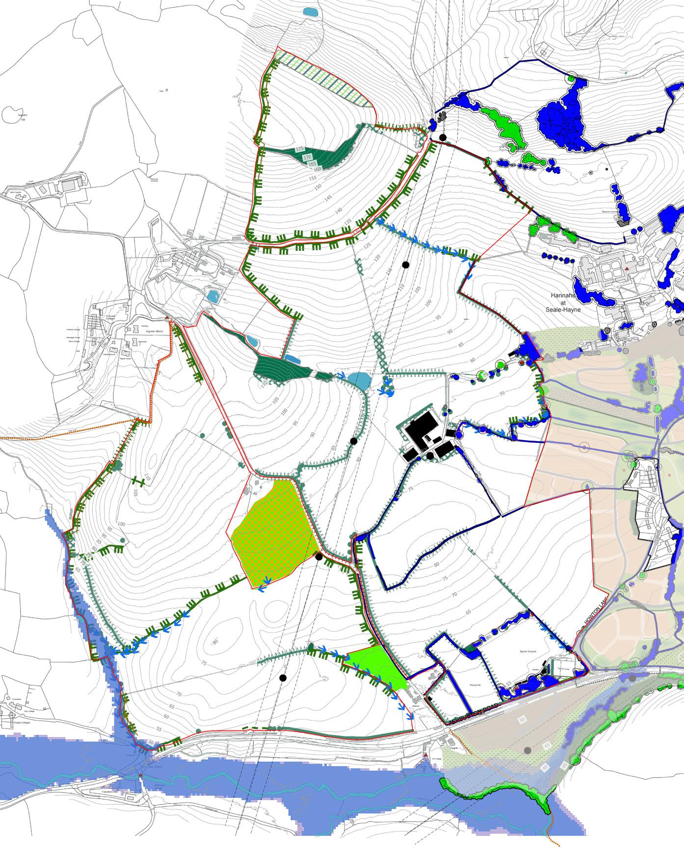
Land West of Houghton Barton Site Constraints Plan
WIXAMS EAST
Bedfordshire, UK | Site Promotion
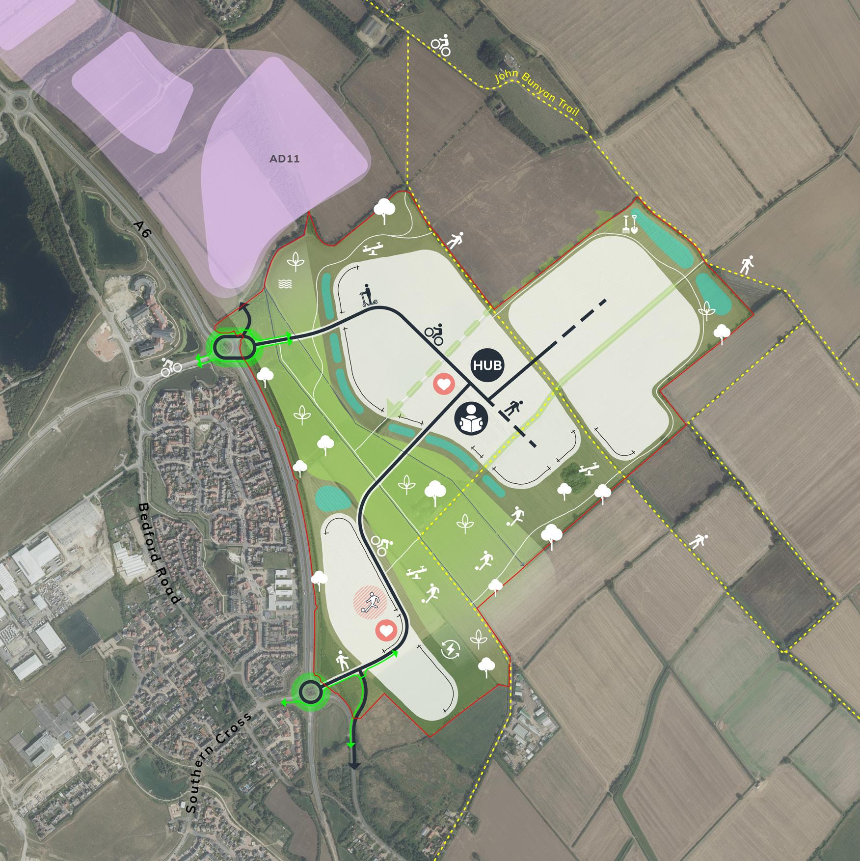
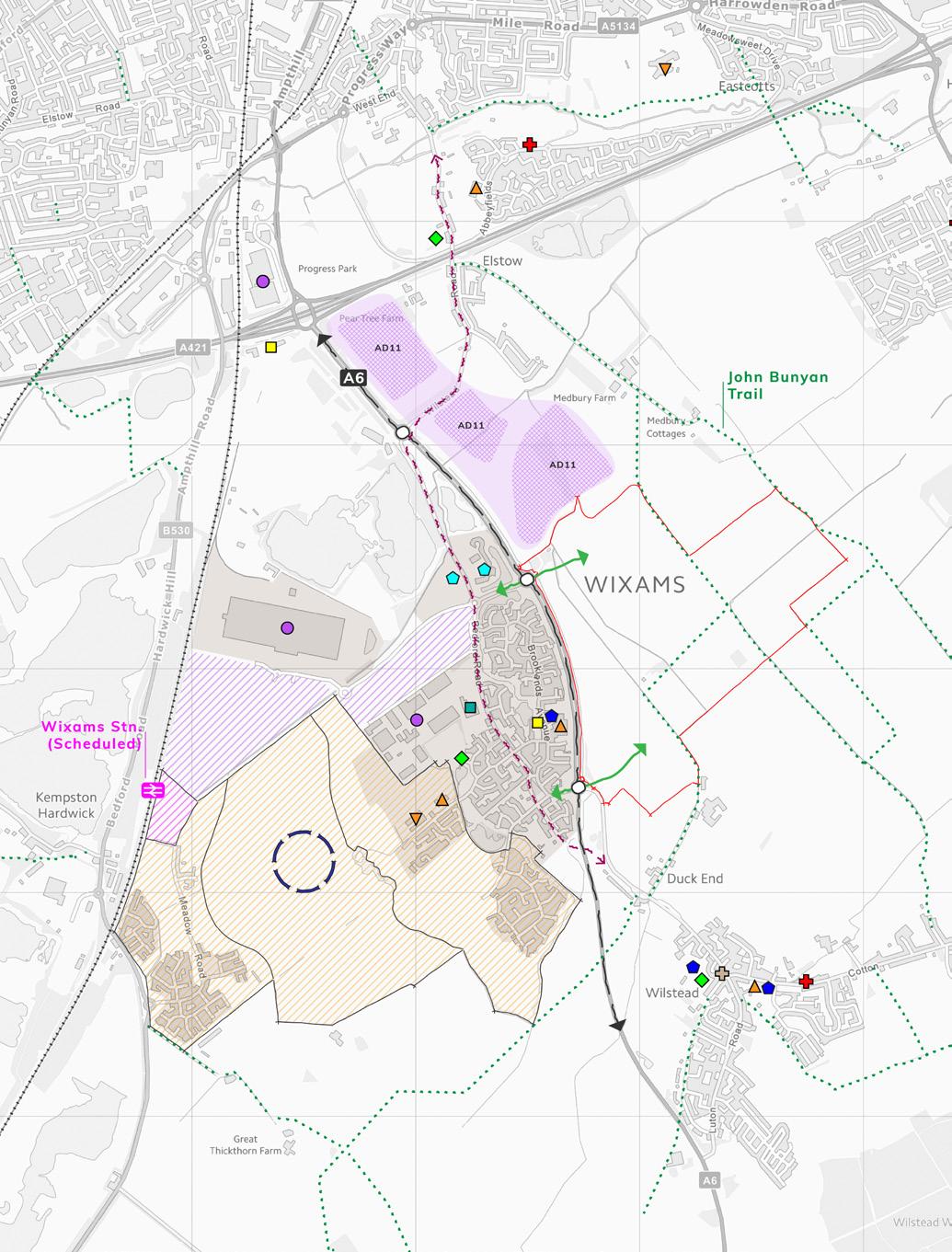
Wixams East lies to the east of new neighbourhoods at Wixams, which have been brought forward by the same land promoter client. The Site presents an opportunity for future growth that would provide approximately 1,800 new homes with supporting facilities and services, a diverse new neighbourhood centre, and a distinctive new parkland destination with links into the surrounding countryside.
10
02
Wixams East Concept Plan
Wixams East will benefit from its proximity to the existing services and facilities at Wixams in the early years, but will deliver primary education, day-to-day shopping, and community and recreation facilities on-site as part of the development proposals. Most importantly, the Site is very well placed to provide easy access for residents to get to the new Wixams train station, and also benefits from immediate access to the John Bunyan Trail bridleway, which provides a direct leisurely route into Bedford. One of the key proposals for Wixams East is Wixams Forest Park, a regional park that will complement the local greenways provided at Wixams so that collectively there is a comprehensive open space offer at Wixams as a whole.
Working with a team of consultants, a short document was prepared on behalf of the client to support the Site’s promotion through the Bedford Borough Council ‘Call for Sites’ process, with a focus on demonstrating how the Site would help to meet the Council’s future growth strategy.
Wixams East has recently been included as a draft allocation within the Bedford Local Plan 2040, highlighting a successful site promotion process.
11
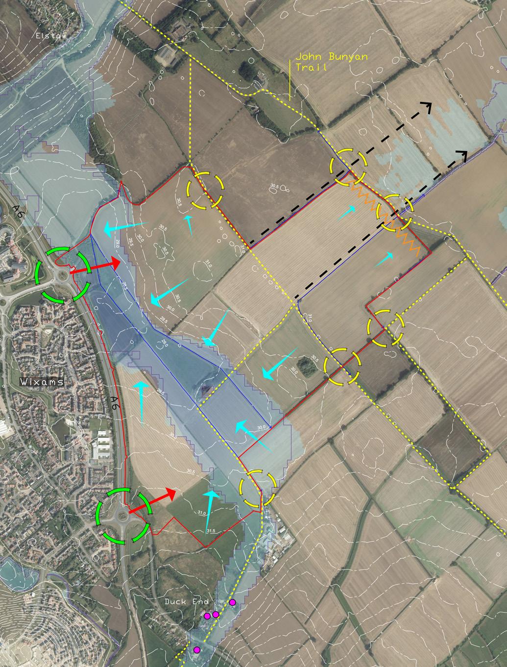
Wixams East Context Plan
Wixams East Analysis Plan
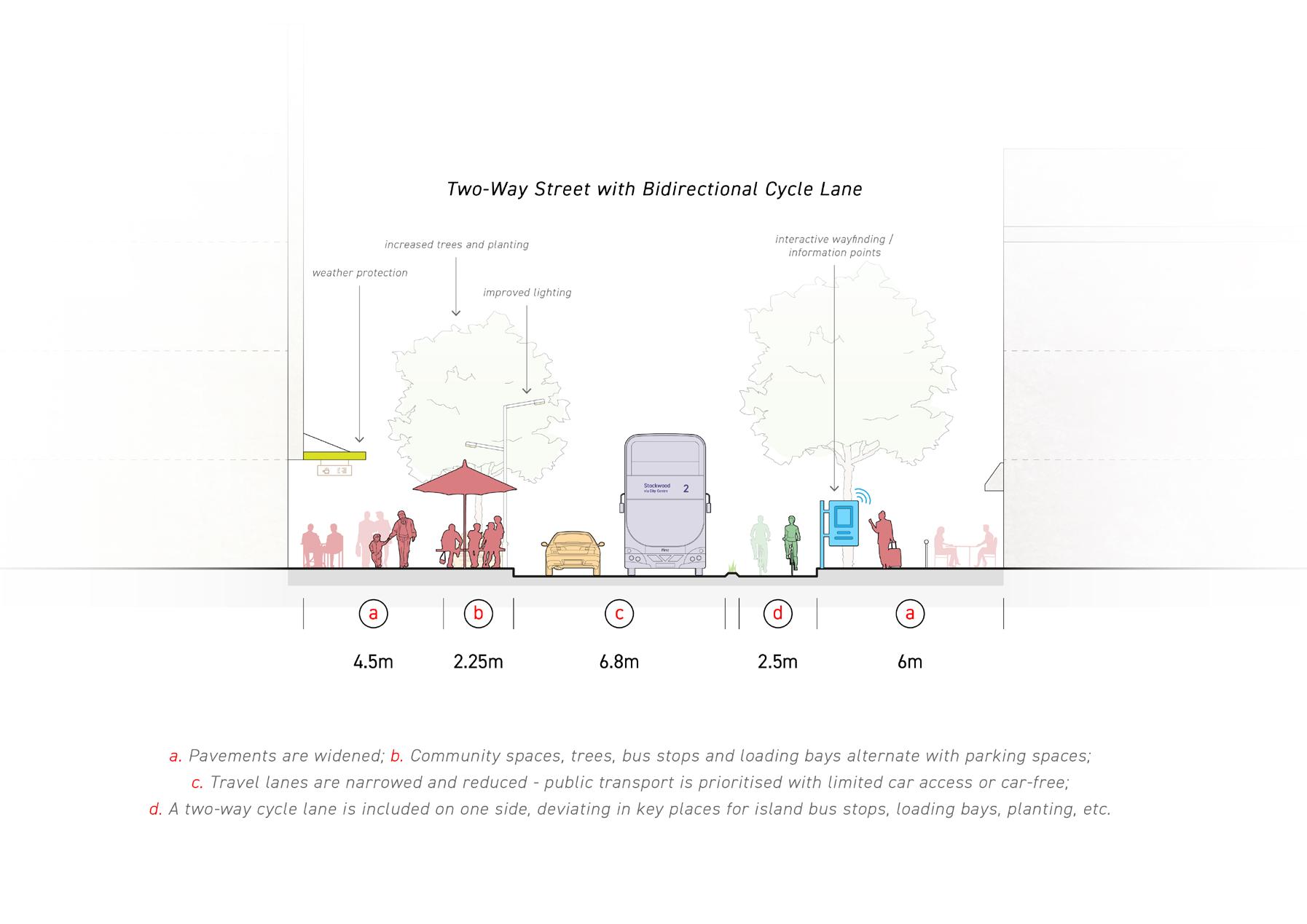
VICTORIA STREET VISION
Bristol, UK | Business Development
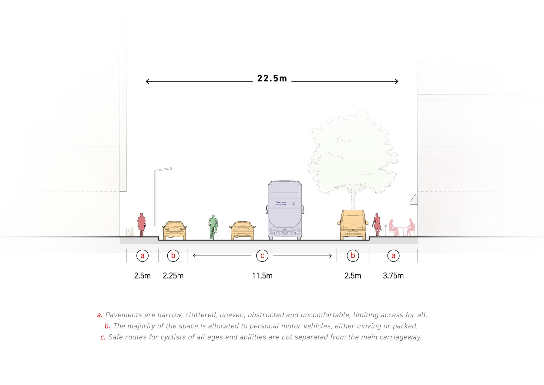
Prompted by the Bristol City Council’s plans to encourage walking and cycling in the city centre following a £250million boost for local authorities in England to improve transport infrastructure, we produced an emerging vision for Victoria Street, an important and historic link between Bristol Temple Meads Station and the City Centre.
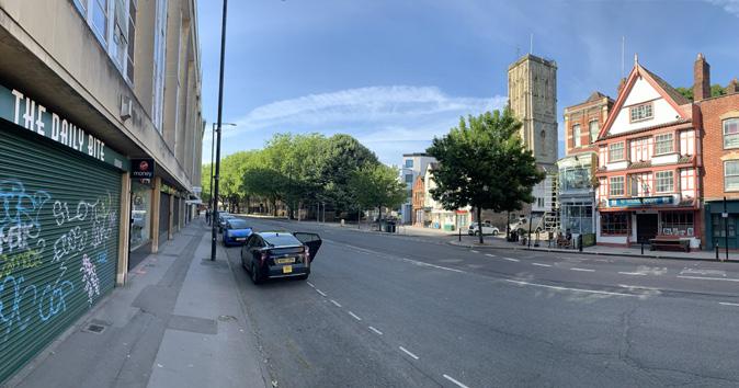
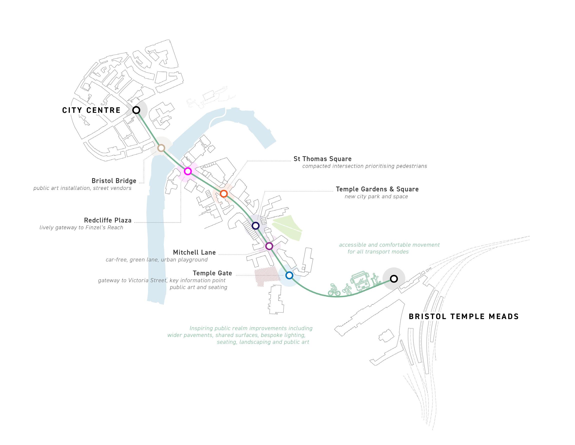
Victoria Street could be transformed to set a new benchmark for city centre streets in Bristol by re-allocating its wide car-dominated space to prioritise people and create room for a variety of uses and activities. Our ideas aimed to support wider discussions considering the relationship between health and our urban environment, and the principle that streets can be re-imagined to meet larger social, economic, and environmental goals. We generated a huge amount of public interest, and were featured positively by some online publications.
https://www.bartonwillmore.co.uk/Knowledge/News/2020/Vision-for-Victoria-Street%E2%80%93-a-benchmark-for-green
12
03
Victoria Street Concept
EXISTING CONDITION:
PRIORITISING PEOPLE:
13
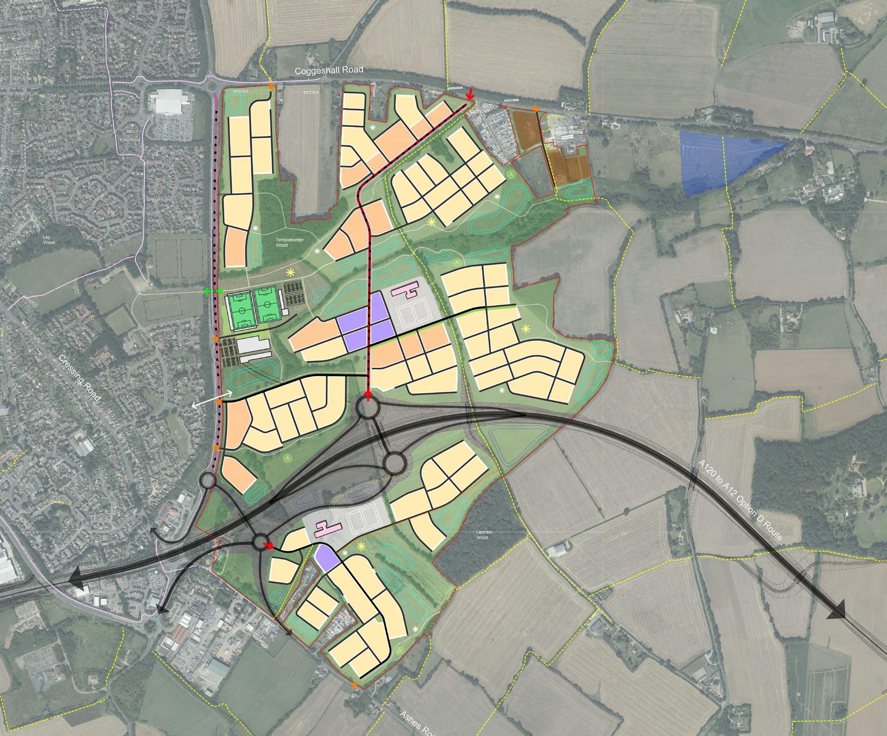
TEMPLE BORDER
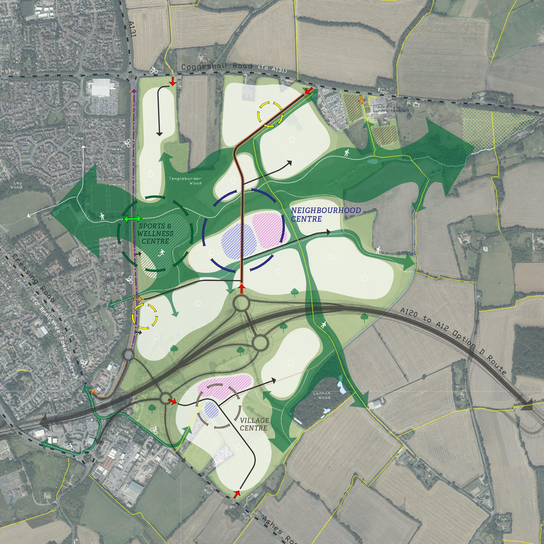
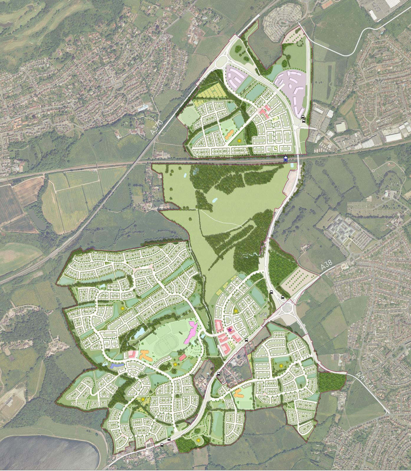
Essex, UK | Site Promotion
Temple Border lies to the east of Braintree, with land forming part of a planned diversion and upgrade to national highways infrastructure that has afforded an opportunity for future growth. The concept shows how the planned diversion could be incorporated into the proposals, including modifications to secondary infrastructure that would facilitate permeability into Braintree.
The emerging proposals would provide up to 2,500 new homes with supporting facilities and services, a sports and wellness centre, employment opportunities, education facilities, access to an enhanced natural environment, and a central green corridor that would become a distinctive permeating feature between Braintree and the Site. Working with a team of consultants, a short document was prepared on behalf of the client to support the Site’s promotion through the Braintree District Council ‘Call for Sites’ process.
14
04
Temple Border Concept Plan
15
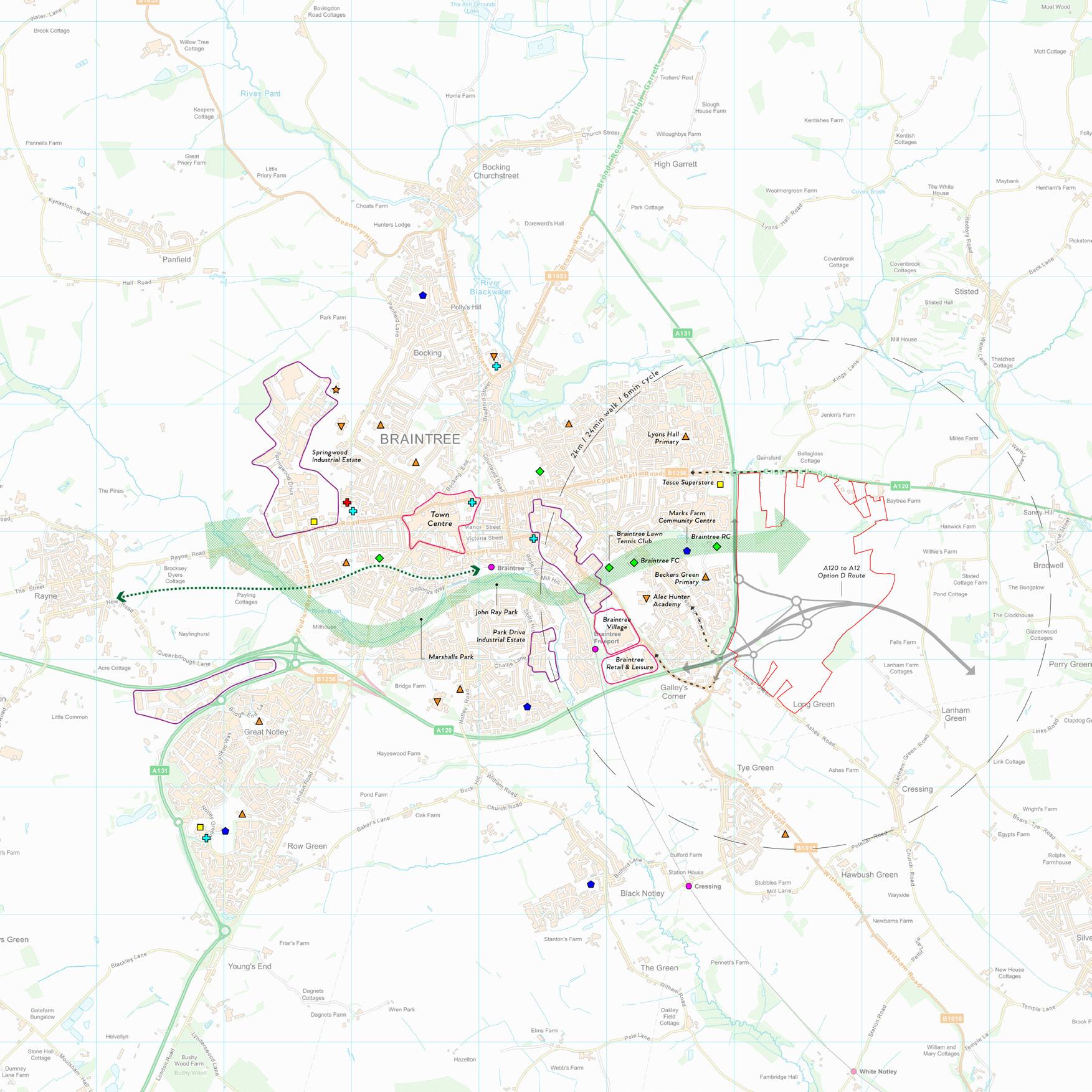
Temple Border Context Plan
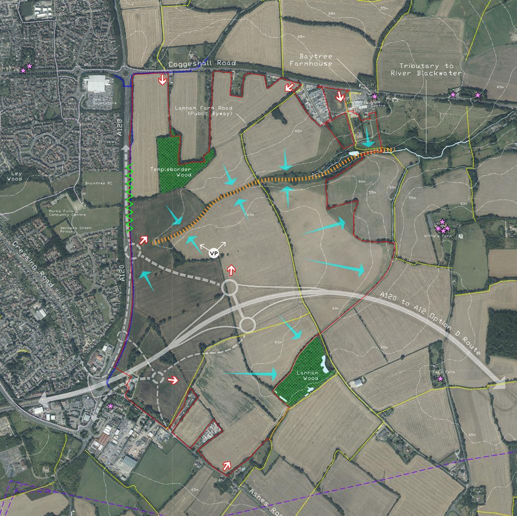
Temple Border Analysis Plan
Temple Border Supporting Land Use Plan
The emerging proposals presented within the site promotion document are underpinned by a supporting land use plan (above) - a technical drawing developed by the consultant team to determine the capacity of the site and to test aspects of urban form. This includes considering: a sustainable drainage strategy; an integrated movement network; variations of urban form that respond to local patterns; a distinctive relationship between new development and nature; an indicative sports centre layout; opportunities for biodiversity net-gain; and a balanced delivery of accessible facilities and services. At this early stage, this level of detail has been produced for the information of the client and consultant team only, but serves to root our vision within a sound technical framework.
A key objective of the emerging proposals was to demonstrate that the Site can provide a sustainable extension to Braintree, rather than a new remote settlement, by capitalising on the movement opportunities afforded by the planned highways improvements. The diversion of the A120 and downgrading of the existing north-south section creates the opportunity for a high quality green link between new and existing communities, providing direct access into the existing pedestrian and cycle network that connects to local destinations. Initial discussions were held with Braintree Rugby Club to corroborate the suitability of through access, which they supported in principle. It is envisaged that the crossing of the downgraded road will be delivered at-grade as part of a calm traffic environment that will provide accessibility for all.
16
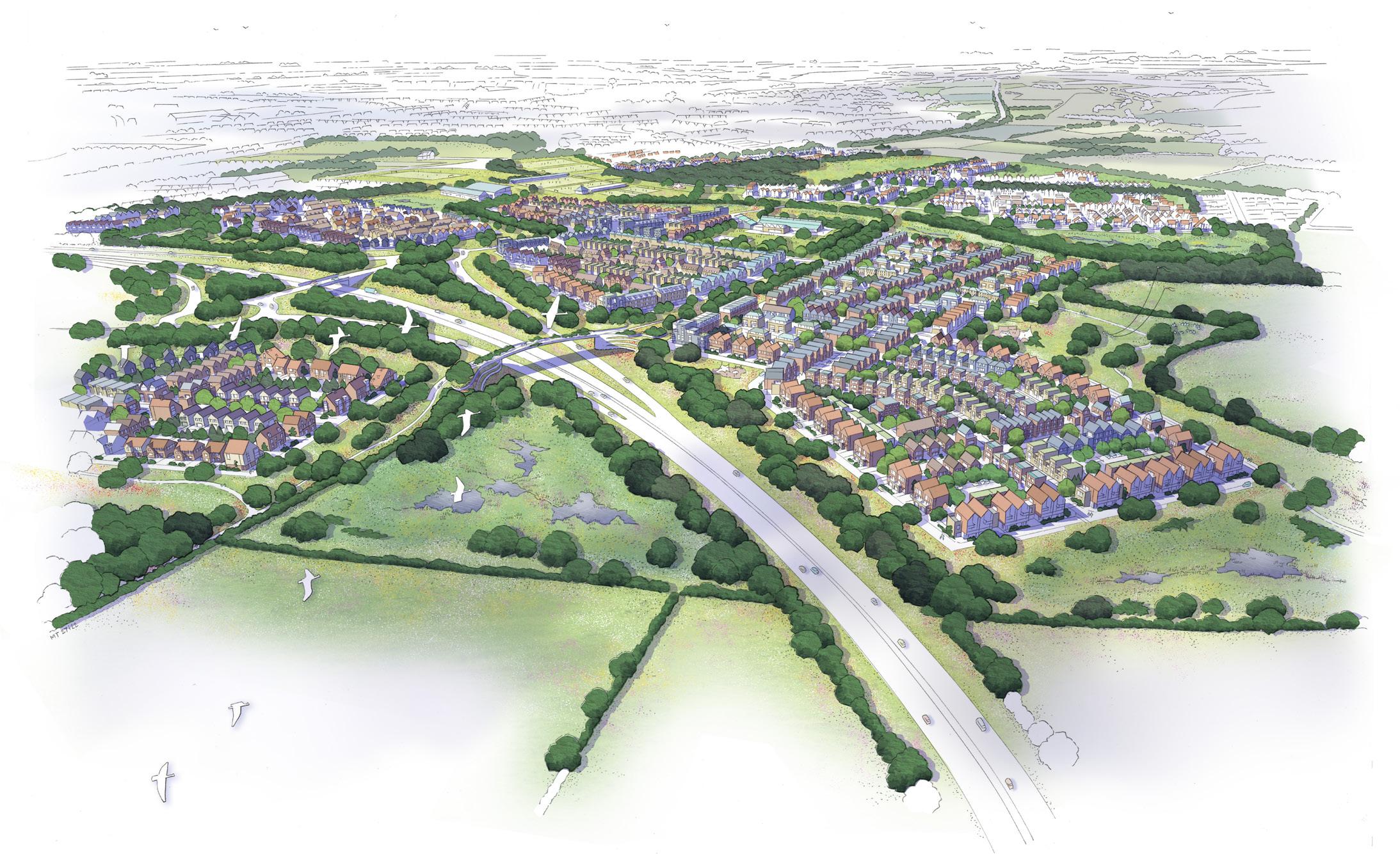
Temple Border Artist’s Impression Drawing * produced by colleague
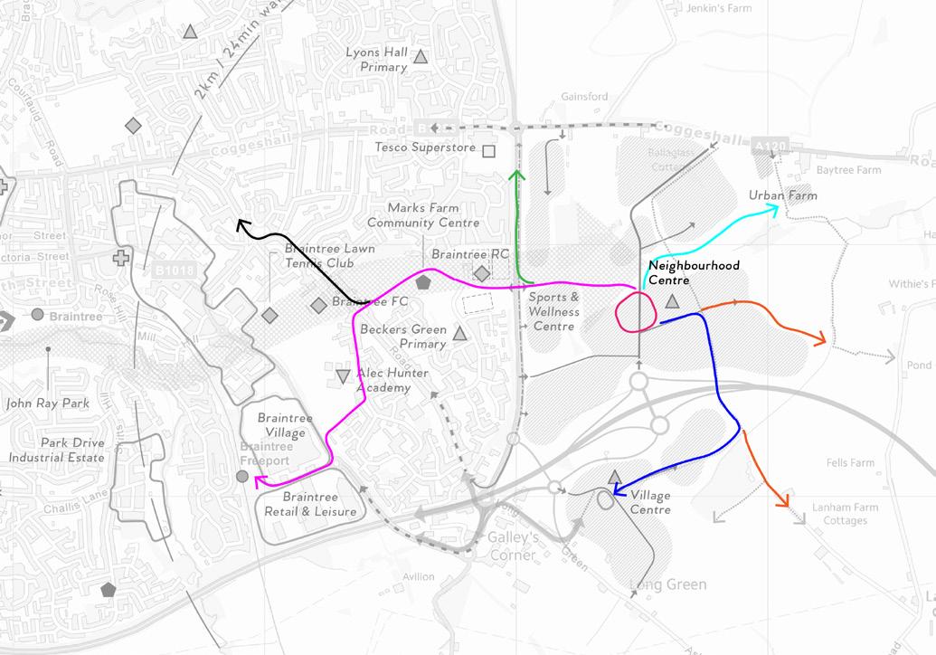
17 New pedestrian/cycle 'green' bridge connecting the Temple Border community (Lanham Farm Public Byway) Lanham Wood Green gateway to Braintree Planned A120 diversion and new eastern gateway to Braintree and Temple Border
Destination (distance) ~ Walking ~ Cycling ~ Route to Tesco Superstore (1km) 12 mins 3 mins Route to Braintree Freeport Stn. (2km) 24 mins 6 mins Route to Braintree Town Centre (3km) 36 mins 9 mins Route to Urban Farm (750m) 9 mins 2 mins Route to Village Centre (1.25km) 15 mins 4 mins Routes to Countryside (within 850m) 10 mins 3 mins
Local Pedestrian & Cycle Accessibility from ‘Neighbourhood Centre’
PICKEDMOOR
South Gloucestershire, UK | Outline Planning Application
Pickedmoor lies on the north western edge of Thornbury, presenting a logical extension to the permitted Park Farm development. Working with a team of consultants, a Design & Access Statement was prepared on behalf of the land promoter client to support an Outline Planning Application for: up to 595 dwellings (use class c3); land for a primary school (use class d1); up to 700m2 for a retail and community hub (use classes a1, a2, d1); a network of open spaces including parkland, footpaths, allotments, landscaping and areas for informal recreation; new roads, a sustainable transport corridor (including a bus link), parking areas, accesses and paths; and the installation of services and drainage infrastructure.
18
05 Pickedmoor Illustrative Masterplan
The Site comprises approximately 36ha of predominantly agricultural fields of an irregular pattern, situated within the low-lying landscape of the Severn Vale. The Pickedmoor Brook runs from east to west within the southern area.
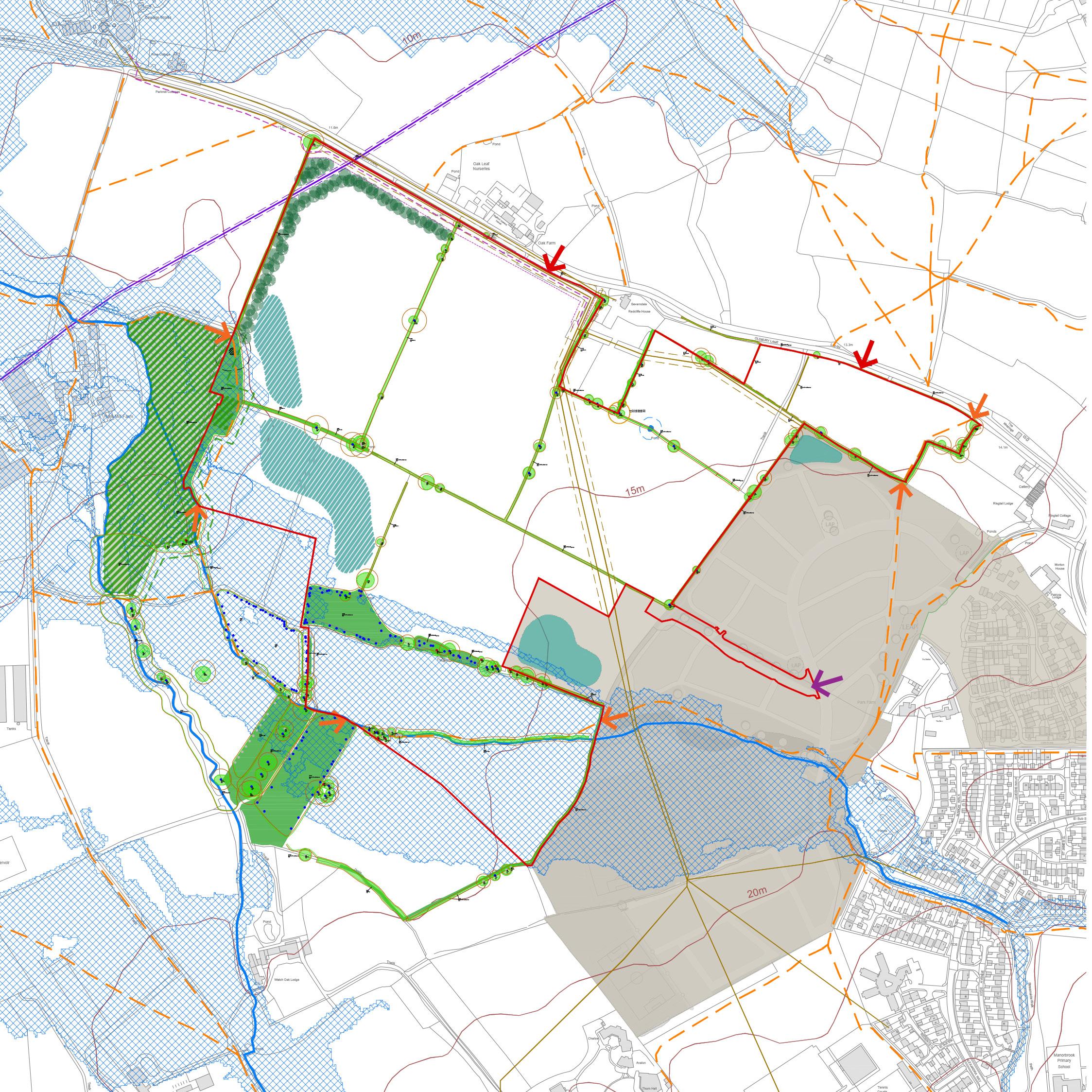
The proposals were subject to a comprehensive consultation process with the local authority, which resulted in an evolution of character and placemaking principles, improvements to the arrival experience, refinement of the play strategy, changes to the amount and scale of housing and other land uses, and enhancements to the landscape areas to deliver increased biodiversity net-gain. However, the local authority was unable to determine a decision, citing concerns in relation to the loss of high-grade agricultural land, development within the countryside and outside the settlement boundary, and potential harm to local heritage assets. The proposals were later approved by a planning inspector following an appeal launched by the Applicant. In the appeal report, it was stated that “these adverse impacts would not significantly and demonstrably outweigh the very substantial benefits” and that the council was unable to demonstrate the supply of land to meet its housing needs.
19
Pickedmoor Constraints & Opportunities Plan
Pickedmoor Land Use & Access Parameter Plan
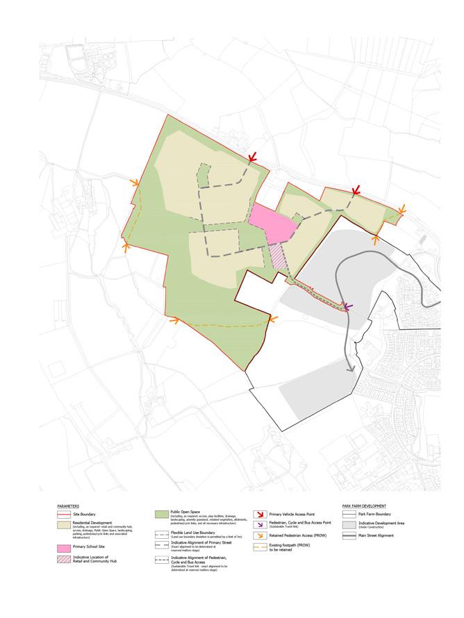
A mixed-use activity area is proposed at the heart of the scheme where the primary school, retail and community space are co-located with the Destination Park at a nodal point formed by the junction between Main Street at the Sustainable Transport Link to Park Farm. This collection of uses will create a vibrant and convivial centre point to the development, benefiting the community by providing convenient local facilities where people can learn, shop, meet, work and play. Its accessible location will encourage sustainable active travel by foot, cycle and bus, with visitors afforded the choice of using the street network or routes along green links that permeate the scheme.
20
Illustrative Layout of Mixed-Use Activity Area
The masterplan has been structured to provide three views that aim to provide the new community with a visual connection to the tower of St Mary’s church that is visible, in part, above the intervening vegetation and tree canopies The western-most of the three views forms a Priority Vista, as shown on the adjacent diagrams.

21
Priority Vista Plan
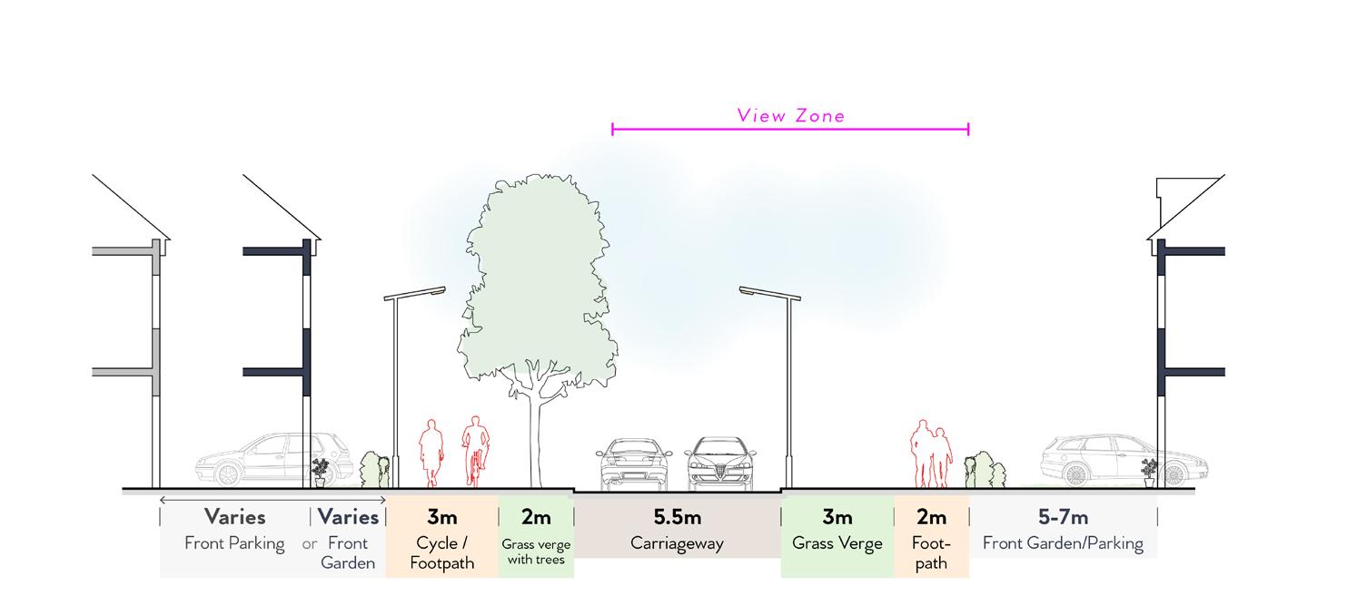
Streets along the Priority Vista will include generous grass verges to create a wide view corridor. Street trees with will be planted on one side of the street to enclose, soften and frame the view.
Illustrative Layout of Priority Vista
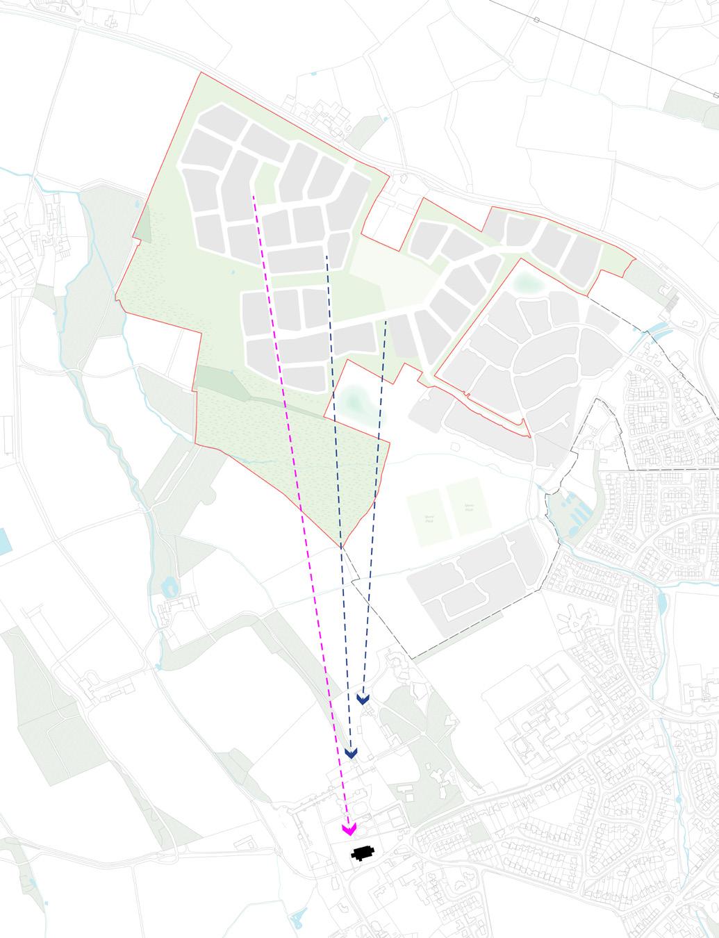
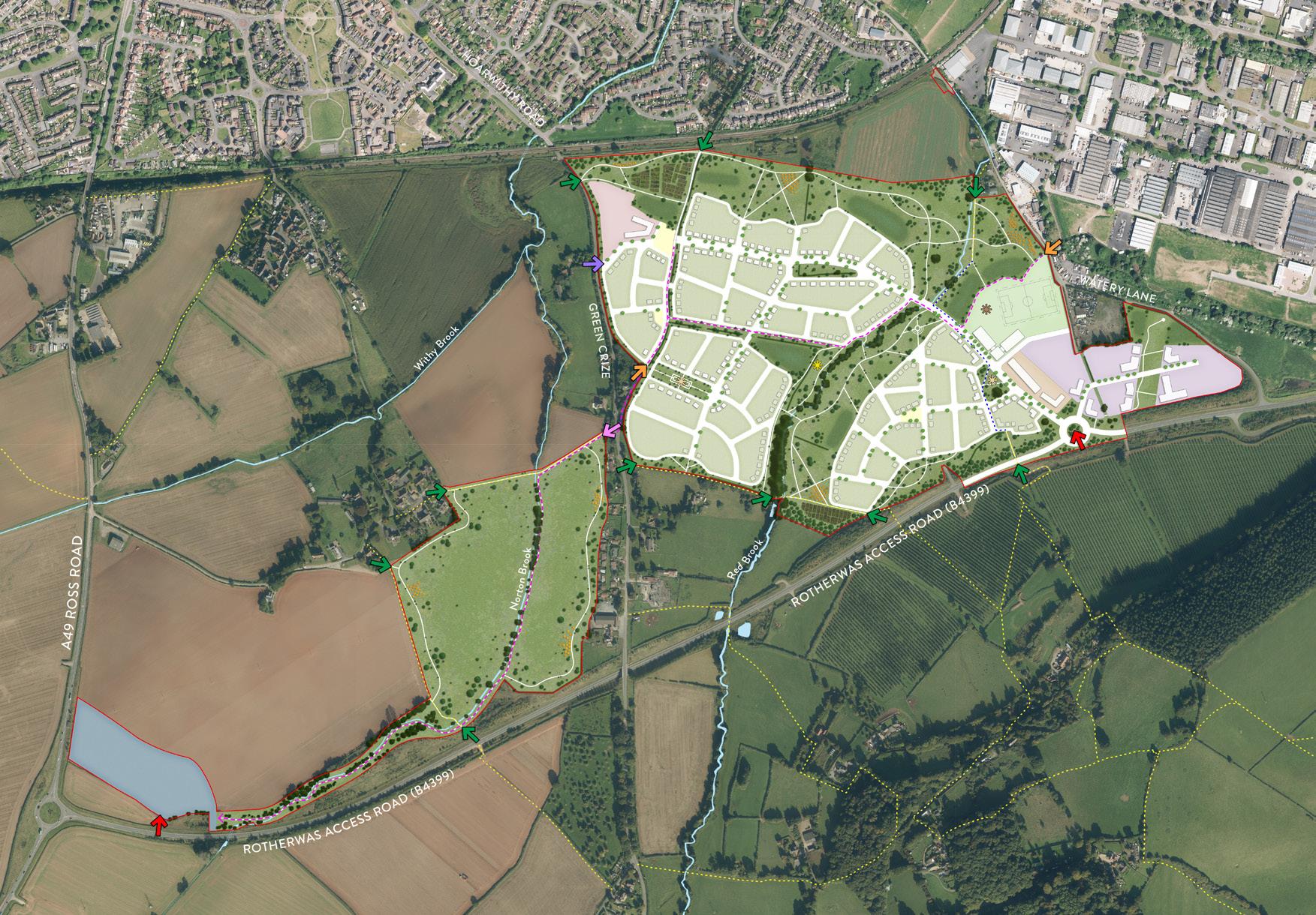
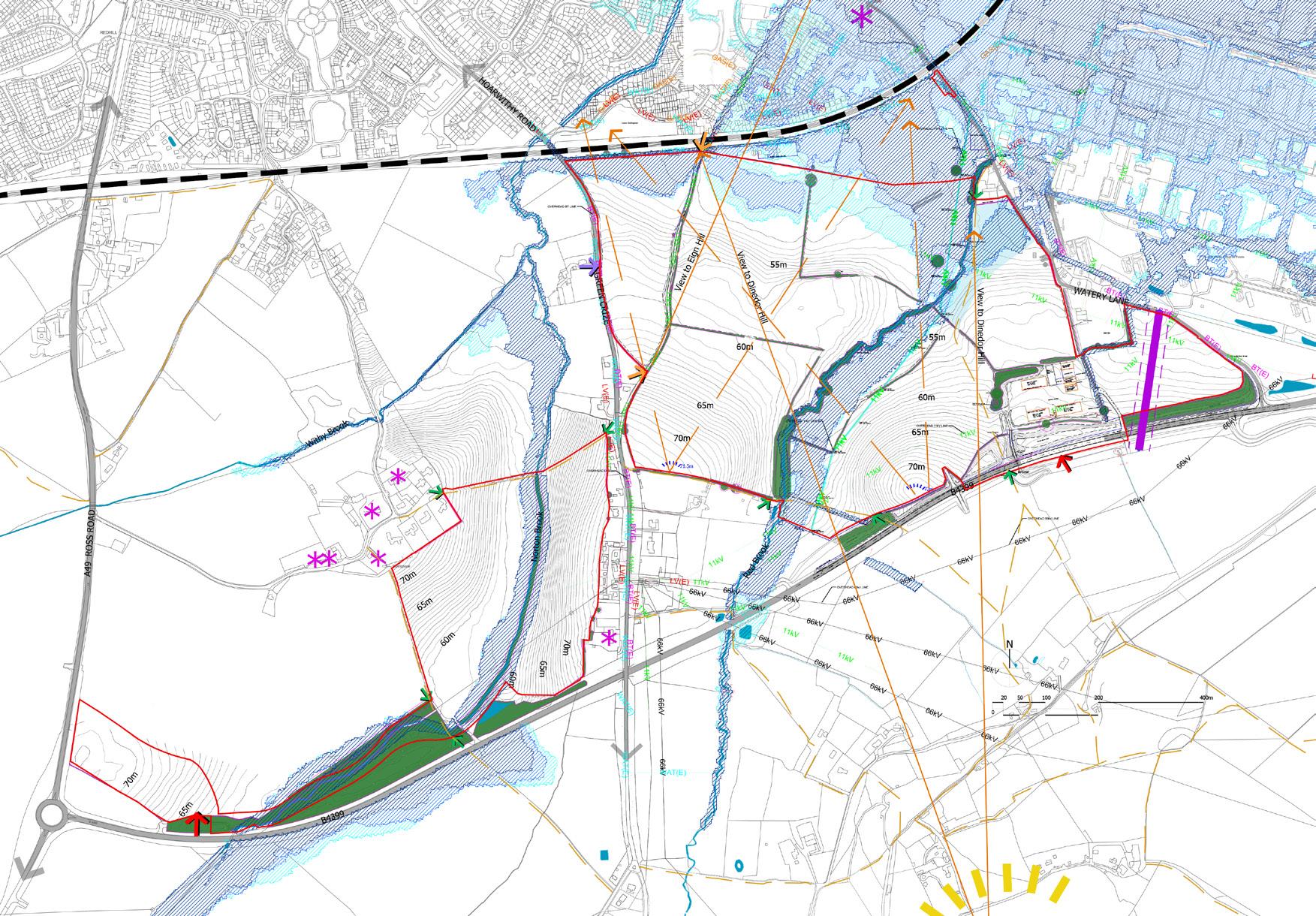
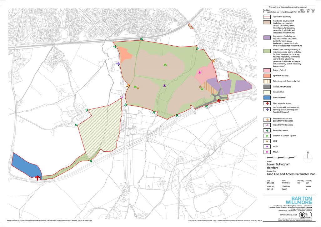
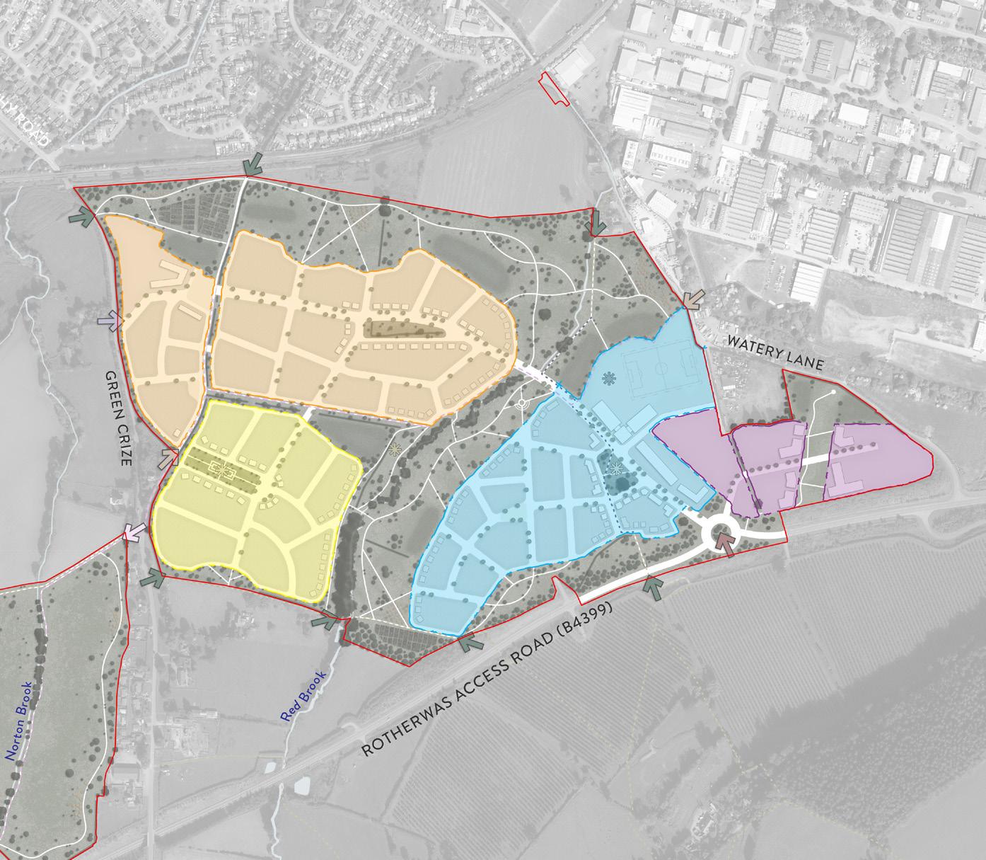
LOWER BULLINGHAM
Herefordshire, UK | Outline Planning Application
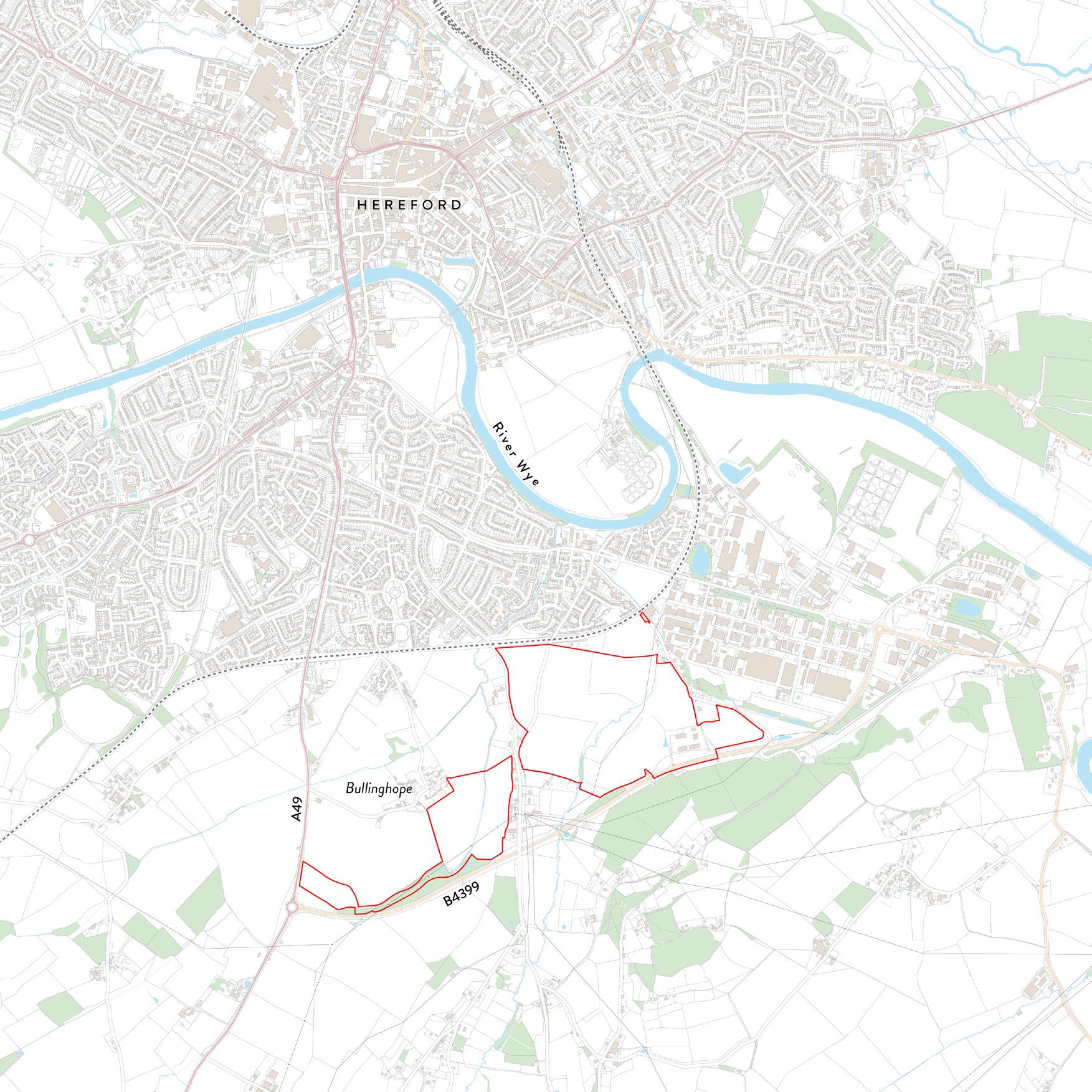
Lower Bullingham lies to the south of Hereford, on land allocated for mixed-use development within the Herefordshire Local Plan. Working with a team of consultants, a Design & Access Statement was prepared on behalf of the national housebuilder client to support an Outline Planning Application for:
‘up to 1,300 dwellings (including specialist housing), B1, B2 and B8 employment uses, a Neighbourhood Community Hub, a new primary school, a Park and Choose, a country park, public open space, access, drainage and other associated works and demolition of existing industrial buildings. All matters are reserved for future consideration save for access.’
22
06
Dinedor Hill Rotherwas Industrial Estate
Lower Bullingham Site Location Plan
23
Lower Bullingham Illustrative Masterplan
Lower Bullingham Constraints & Opportunities Plan
Lower Bullingham Land Use & Access Parameter Plan
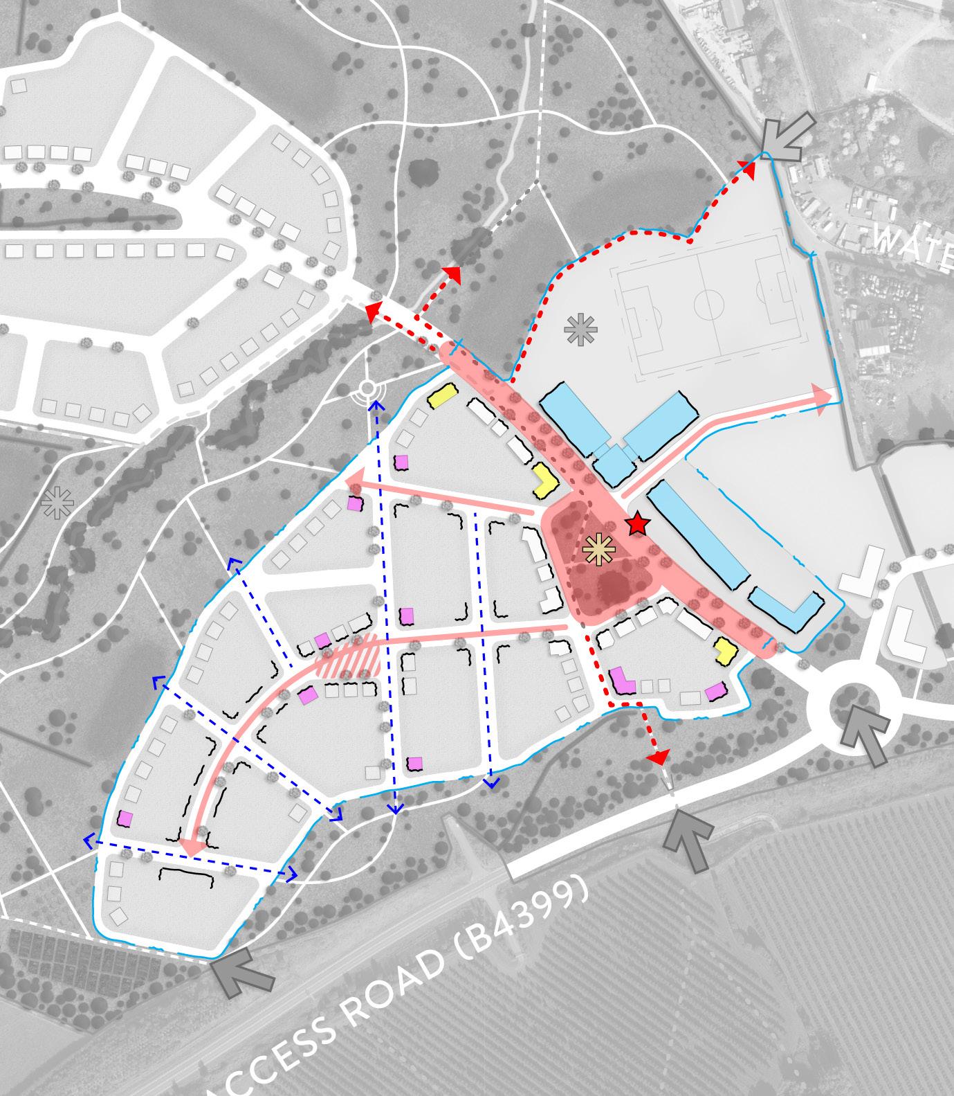
Key placemaking features of the proposals include: a series of community green spaces within the residential areas that are linked by important movement routes; a distinctive linear park along the Red Brook corridor; open spaces at high points of the Site that provide long distance views to local landmarks; a strategic pedestrian and cycle link that connects the development from the proposed Park & Choose to Watery Lane; the conservation and enhancement of the ‘Rotherwas Ribbon’, an identified prehistoric archaeological feature of national significance; and the co-location of the community hub, primary school, employment opportunities, transport interchange facilities, and public spaces to form the heart of the scheme.

The development proposals at Lower Bullingham sought to add variation to the scheme by establishing four broad character areas, responding to the surrounding built environment and placemaking opportunities. The distinction of character areas, through varying elements of scale, density, form, land use, typologies, building appearance, and landscaping treatments, will help people find their way around, contribute towards a sense of place, and provide a level of richness and delight to the new community.
24
Lower Bullingham Character Areas Plan
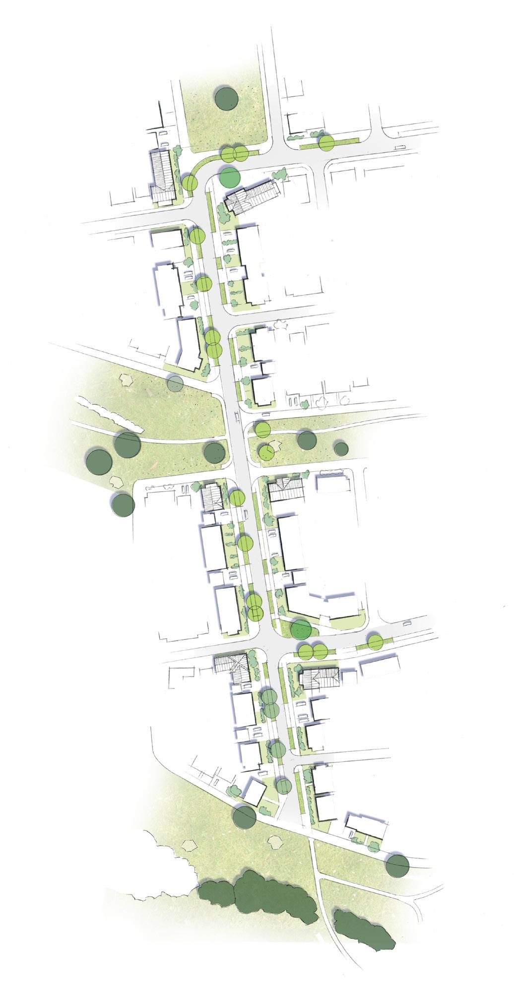
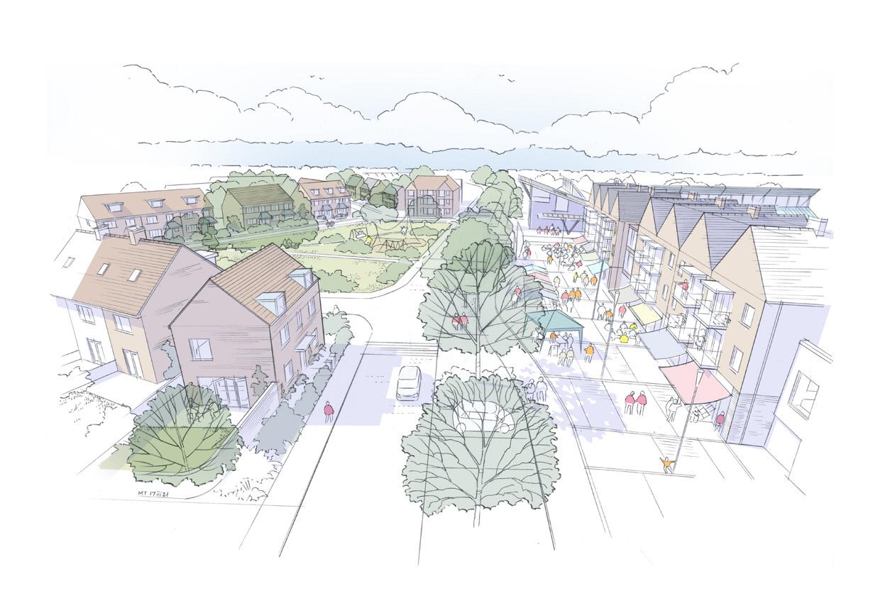
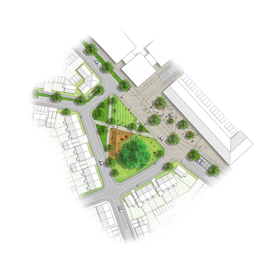
The ‘Central Bullingham’ Character Area comprises a mix of uses, including the neighbourhood community hub and school, and is characterised by an increased scale and density, a rectilinear urban form that creates compelling view corridors, strong and continuous building lines, and consistent plot widths. The primary movement route and key space has a contemporary and vibrant feel to create a distinctive gateway, animated by a variety of space typologies and features including open space, block paving, hard surface public realm suitable for events, a retained mature tree, street tree planting, a play area, a designated pedestrian and cycle path, seating areas, and a mobility hub.
25
Placemaking Plan for ‘Central Bullingham’ Character Area
Local precedent: Continuous building line on linear street at Waggoners Way
* produced by colleague
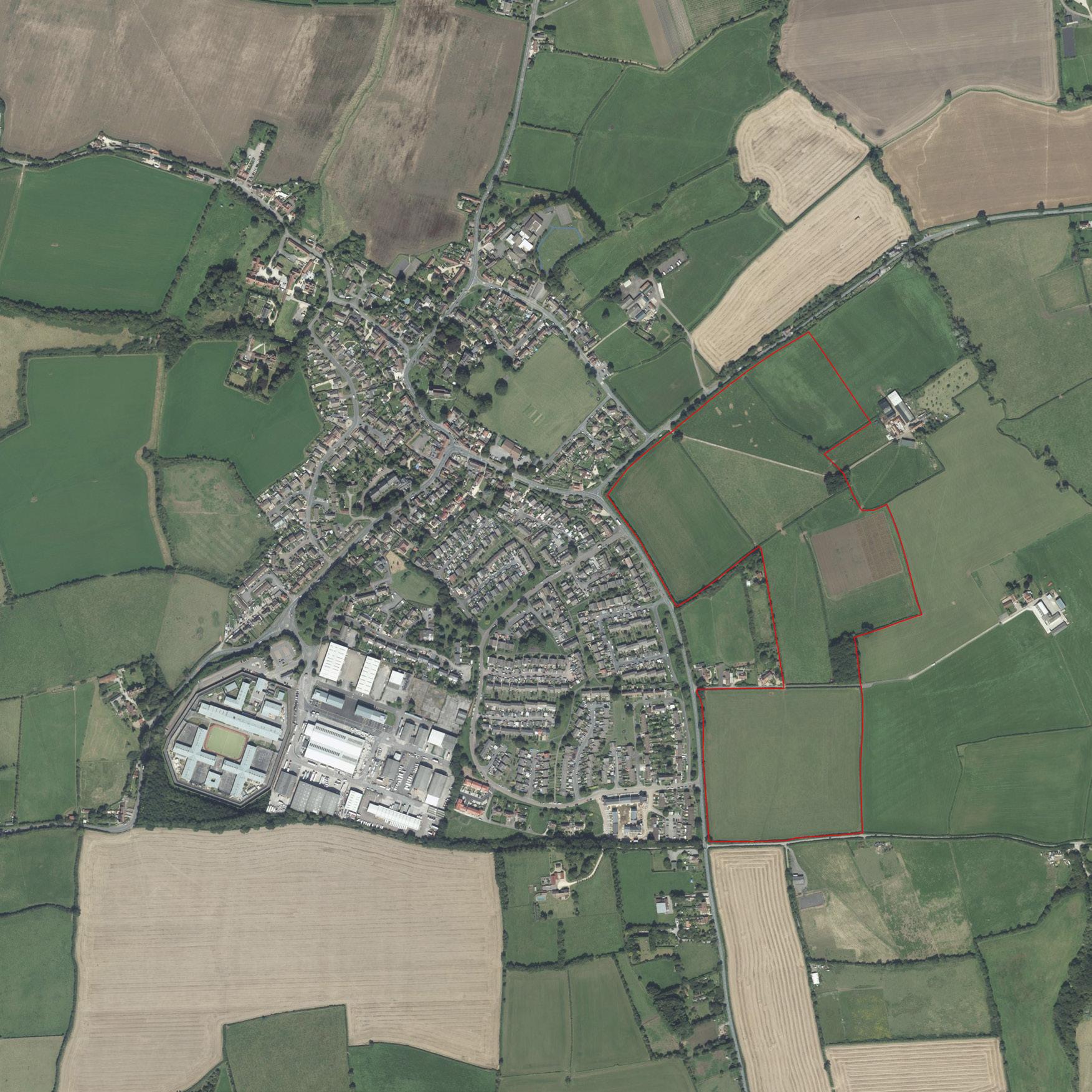
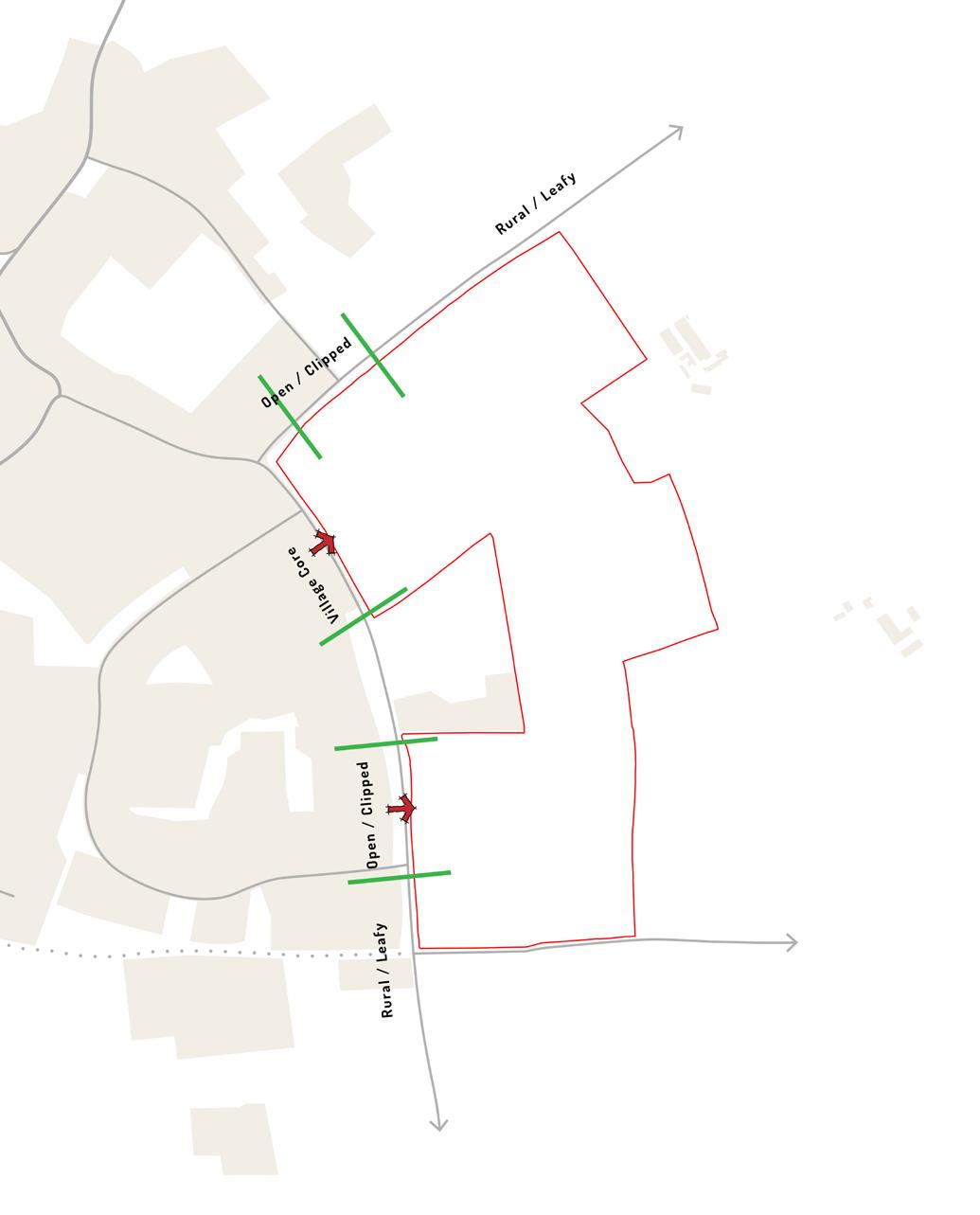
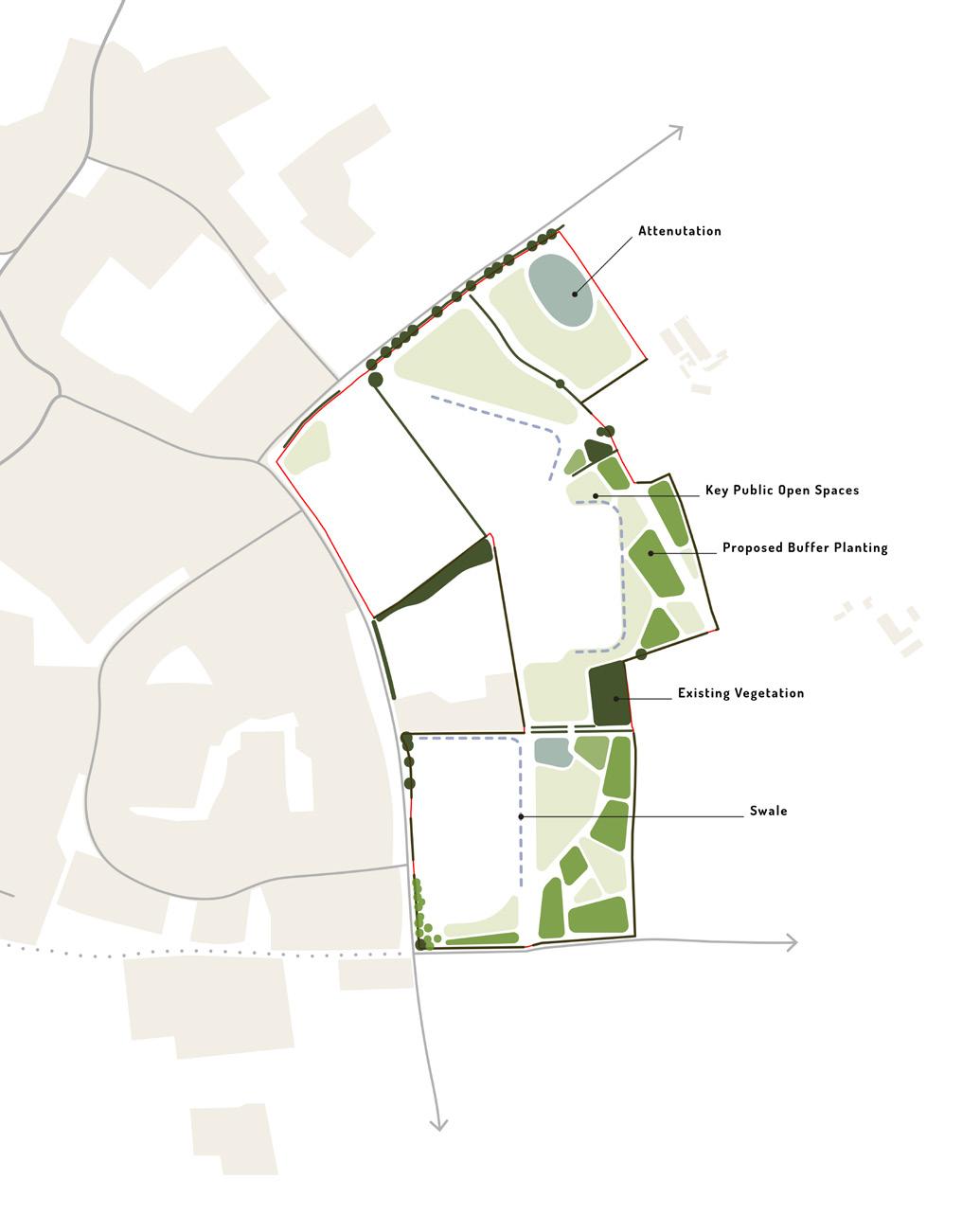
ABSON ROAD
South Gloucestershire, UK | Site Promotion
Land at Abson Road presents an opportunity for non-strategic residential development within the settlement of Pucklechurch, with the potential to deliver approximately 310 new homes in close proximity to a wide range of existing facilities, services, and employment opportunities.
To strengthen the emerging proposals, and to support the Site’s promotion, the client and design team undertook a process of Design Review with the Design West Review Panel and a Planning Officer from South Gloucestershire Council. The Panel was invited to a site visit accompanied by the design team, which was followed by a presentation of the emerging proposals and an open discussion. The Panel provided a summary of their observations in the form of a written letter and plans, which led to a series of evolutions within the emerging proposals.
26
07 Abson Road Site Location Plan
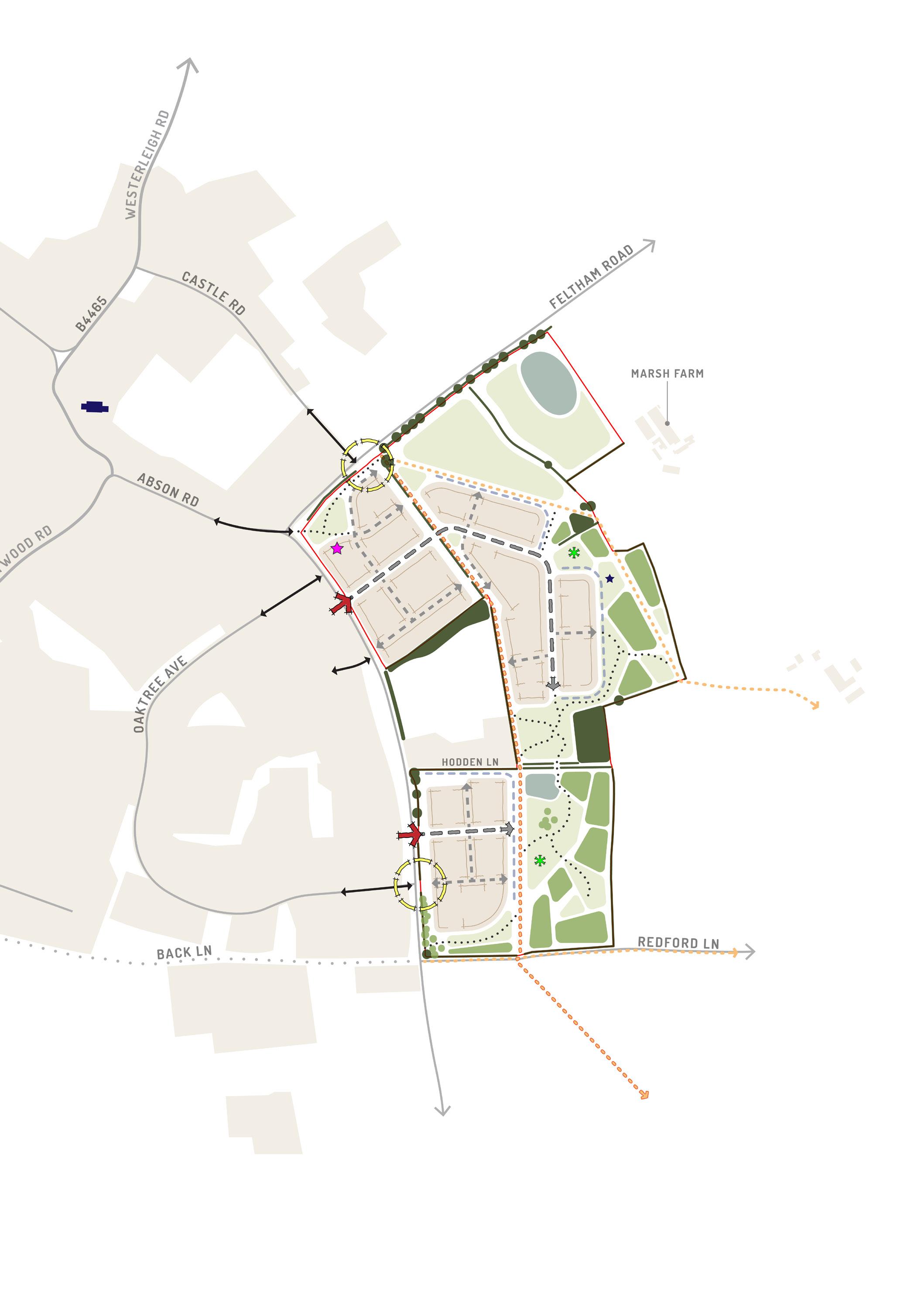
Design Feature: Drawing on local examples, building frontages have been arranged to frame a village green type space at the intersection of Abson Road and Feltham Road, which will create a distinctive gateway to the site arriving from the village centre. This space is also identified as a suitable location for a potential community use building that would establish an active new village destination.
27
Abson Road Concept Plan
Contextual analysis, site assessment work, and consultation undertaken by the project team prompted a rationale for design, which aims to maximise the opportunities identified. The rationale is underpinned by a series of structuring design principles that are explored over the following pages to form the emerging concept plan. It was concluded that the development site could be well-integrated into the landscape; would have no material effect on views from the wider rural setting; and its release from the Green Belt would result in minimal harm, as well as enabling extensive enhancement of access to and quality of the remaining Green Belt land.
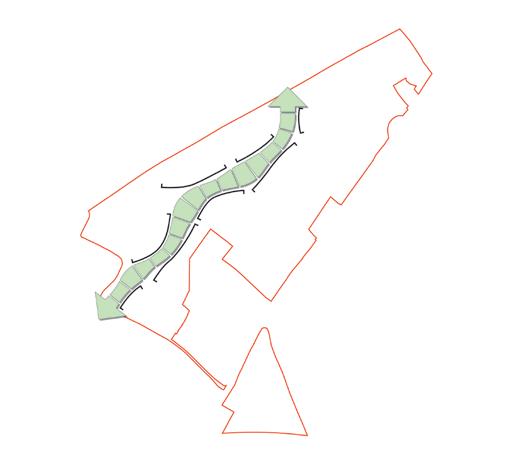
‘Hub & Spoke’ Movement Pattern
Historic maps of the village show that a ‘hub and spoke’ arrangement of streets and spaces had developed, and this was still legible in the current street arrangement.
The design approach aims to develop this pattern of routes as part of the village extension by developing an additional ‘spoke’ that follows desire lines on a broadly north-south alignment connecting with Castle Road. The existing Public Right of Way is well placed to deliver such a connection and support active travel within an attractive green corridor.
In addition, there are opportunities to create village streets and additional pedestrian/cycle routes on desire lines that fulfil similar functions – a multi-route approach that funnel residents towards Castle Road and Abson Road.
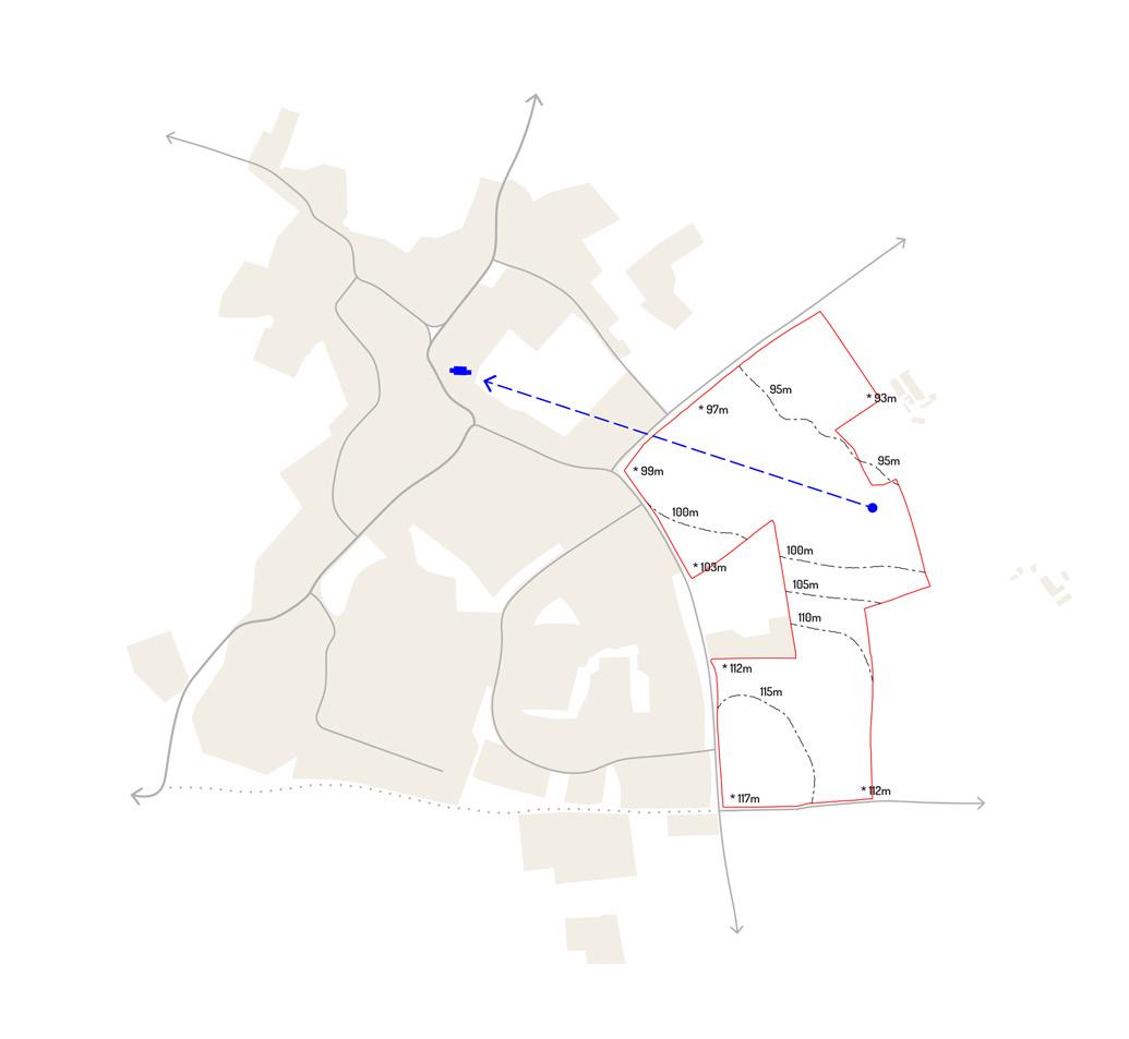
View to St Thomas A Becket Church
The Grade I listed Anglican Church of St Thomas à Becket (1212871), c.300m to the north-west of the site, comprises a tall structure in a prominent location that overlooks the surrounding landscape.
There are existing views of the church tower from the centre and south of the site, as there are from many locations within the wider landscape.
These views are partly obscured by 20thC housing, with no appreciation of the body of the building or its cemetery setting. However, the creation of a distinctive view corridor towards the church tower within the development proposals will help legibility and foster a connection of the new with the old.
Other opportunities to integrate views to the church tower within the proposals will be explored as the masterplan evolves.
28
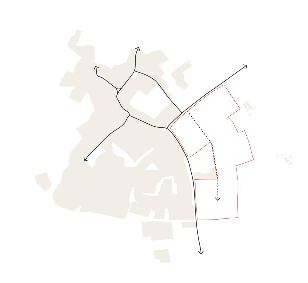
Arrival Experience / Transitional Edges
The development presents the opportunity to provide new gateways into Pucklechurch, acting as a threshold to transition from the rural character to the village character. The arrival experience will be shaped by landscape features, the location and scale of properties, and nodal points at the meeting of routes.
Abson Road could be developed as a village street, with housing frontages providing a responsive character that feels part of the existing village.
New Green Edge
The development of the site will form a new green edge to Pucklechurch by creating a generous, connected, and multifunctional area of open space and green infrastructure along the eastern edges of the site.
This area will play an important role in delivering net gains in biodiversity, establishing a bold and attractive landscape context for the development, filtering views from the wider setting, and providing significant amenity for existing and future residents with attractive views to the east.
A mosaic of biodiversity habitats will be proposed, including woodland, scrub, meadow grassland and wetland habitats, which will support the continuity of habitat and wildlife corridors. The two development areas are bisected by an area of open space near Hodden Lane on steeper ground. These development areas will be connected by the additional ‘spoke’ and other informal paths that wind up the slope.
29
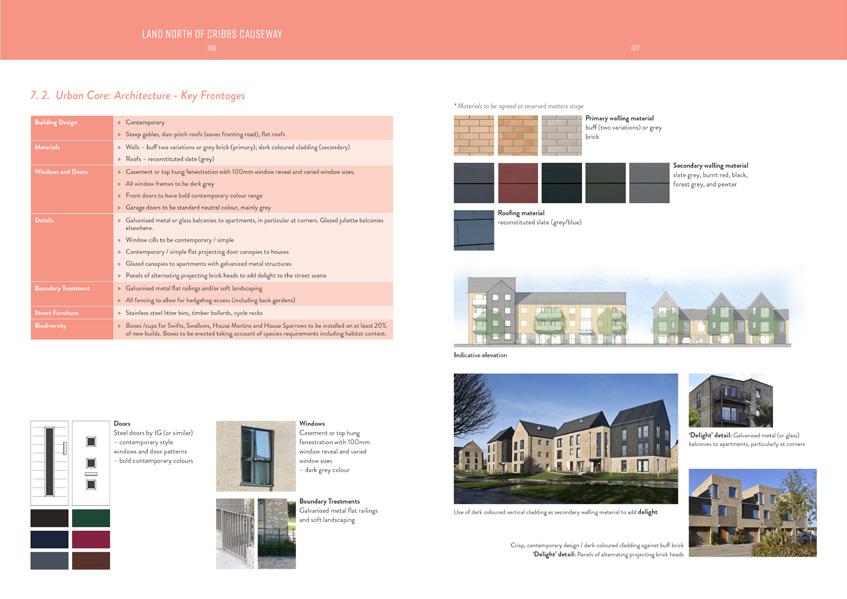
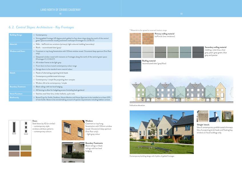
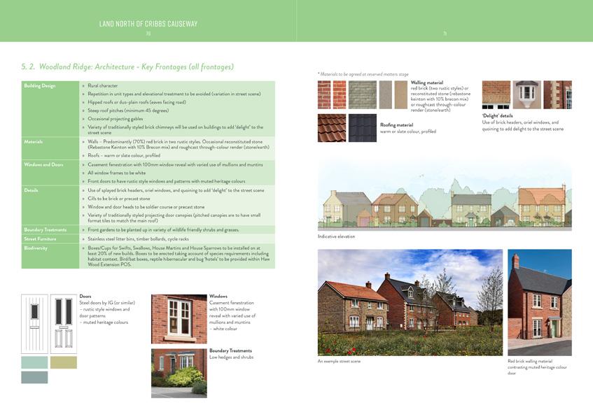
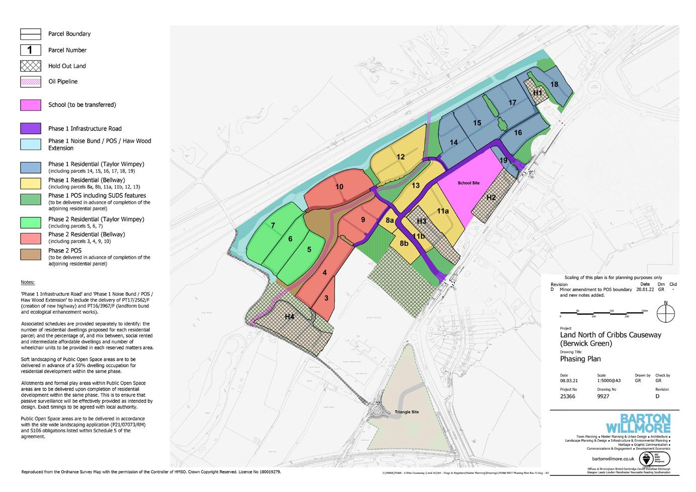
CRIBBS CAUSEWAY
Bristol, UK | Design Code
Cribbs Causeway lies to the north of Bristol, within an area of significant strategic growth under local policy. Working with a team of consultants, a Design Code was produced on behalf of a consortium of national housebuilder clients and in consultation with the local authority to set out a clear set of instructions and design guidance for reserved matters applications, as required by condition of the outline planning permission.
This includes detailed instructions for common site-wide elements, such as parking arrangements and waste collection, as well as detailed instructions for three distinctive character areas with varying elements of urban form, architectural detail, and landscape treatments. The development includes up to 760 new homes.
Following extensive consultation, the Design Code was approved in 2021 and early phases of the development are now under construction.
30
08
Cribbs Causeway Illustrative Masterplan and Parcel Plan
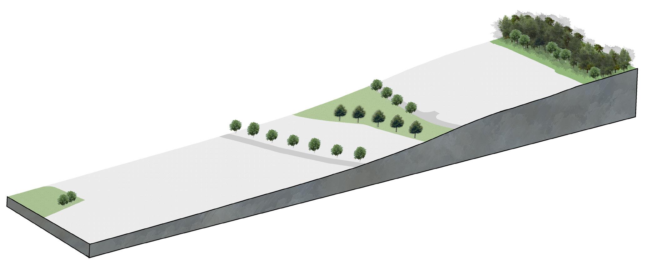
The Design Code aims to ensure that the objectives presented within the outline planning permission are delivered, including a transition of character from ‘urban’ to ‘rural’. This objective was reinforced through a series of ‘strategic character generators’ (above), which provided a framework for the creation of three distinctive character areas, to create a legible and varied new neighbourhood with a strong identity that responds positively to the site and its setting.
The diagram above illustrates one of the key design objectives for the development – to create a layering of new development integrated in the landscape, and a transition from urban to rural. Most of the landscape layers are featured within areas of public open space, but other areas require robust street tree planting to deliver this objective.
31
Rural: woodland ridge
New woodland planting provided on ridge
Transition: central slopes
Built Form Built Form Built Form Landscape Landscape Landscape A A URBAN CORE
Rows of trees provided on northern and southern edge of central green corridor
Urban: URBAN CORE Street trees provided in primary route
Central Slopes
Woodland Ridge
Topography
Central Green
Haw Wood Extension
Primary Movement Route
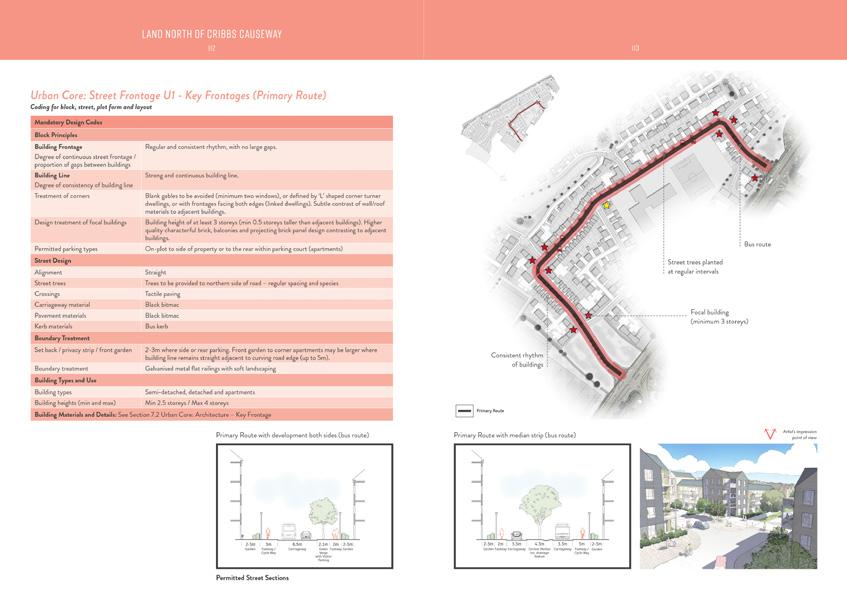
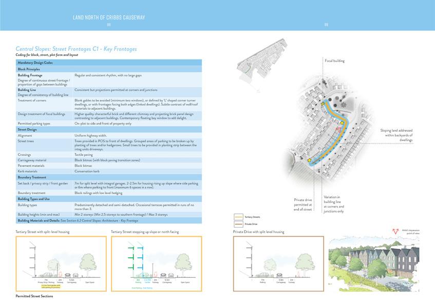
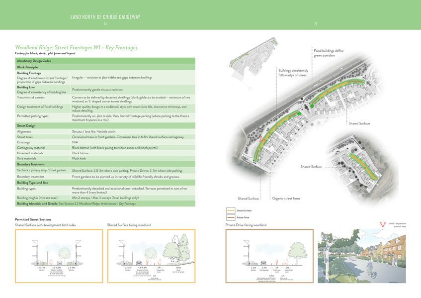
Detailed Design Codes for Character Areas
The Design Code presents detailed instructions for three distinctive character areas with varying elements of urban form, architectural detail, and landscape treatments. The coordinated delivery of distinctive character areas will ensure a consistent design response, help people find their way around, contribute towards a sense of place, and provide a level of richness and delight to the new community.
32
Urban Core
Central Slopes
Woodland Ridge
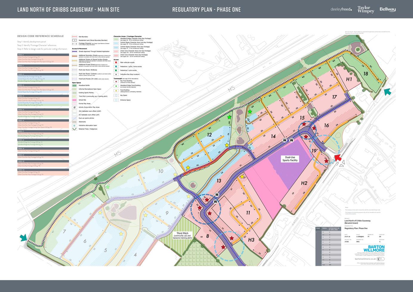
Supporting Plans
In addition to the Design Code, a series of supporting plans were provided to the Council as required by separate conditions of the outline planning permission, including a ‘Phasing Plan’, and ‘Regulating Framework Plan’. The Regulating Framework Plan is presented at 1:1000 scale and sets out the key spatial elements of the development, to be used alongside the Design Code document.
33
Phasing Plan Regulating Plan (Phase One)
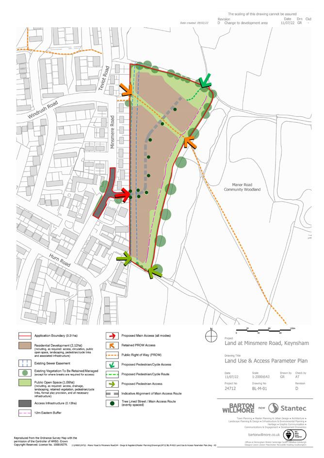
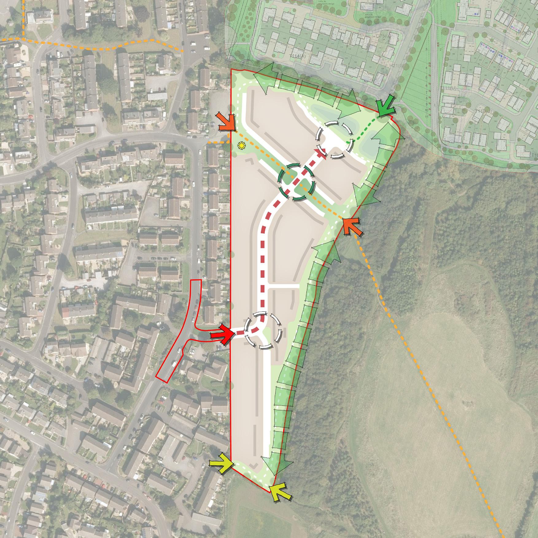
MINSMERE ROAD
Keynsham, UK | Outline Planning Application
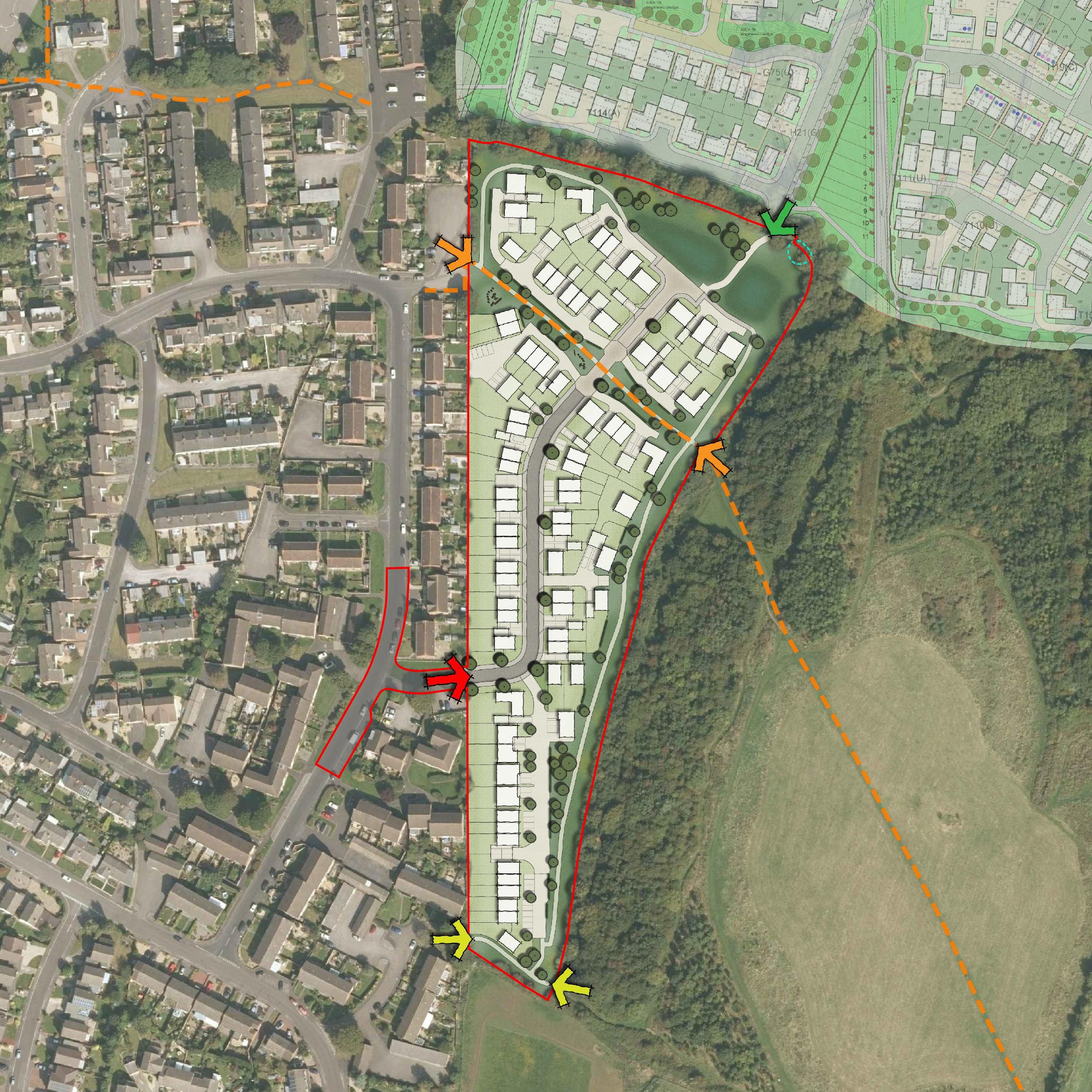
Minsmere Road lies to the east of Keynsham, on land safeguarded for future development under local policy. Working with a team of consultants, a Design & Access Statement was prepared on behalf of the national housebuilder client to support an Outline Planning Application for 70 homes (Use Class C3); new vehicular and pedestrian access on to Minsmere Road, public open space; tree planting and habitat creation; site drainage and associated infrastructure, with all matters reserved except for access.
Following extensive consultation with the local authority, the Outline Application was granted permission by Planning Committee in late 2022.
34
09
Minsmere Road Illustrative Masterplan
WINDRUSHRD HURNLANE TEVIOT ROAD
HYGGE PARK
MINSMERE ROAD MINSMERE ROAD
MANOR ROAD COMMUNITY WOODLAND
The proposals have been designed to deliver 70 new homes at a density compatible with the local area, characterised predominantly by two-storey semi-detached and detached properties. Formal character elements define key movement routes to help establish a legible place, including: consistent building lines and plot widths; tree planting at regular intervals; and repeating house types. Less formal and varied character elements will define other streets and spaces to soften their appearance.
The proposals will be settled within an attractive and multi-functional green infrastructure network. This includes the creation of a green corridor around the existing Public Right of Way, which will establish a transitional gateway to the Manor Road Community Woodland from “urban” to “rural” from west to east. The key transition point is marked by a shared surface area where the routes converge, which will help to encourage slow and considerate movement. An ecological buffer and open space corridor has also been established to protect high value habitats and provide an attractive recreational walking route for the local community in the setting of the Manor Road Community Woodland.
35
WINDRUSHRD HURNLANE TEVIOT
MINSMERE ROAD MINSMERE ROAD
ROAD
MANOR ROAD COMMUNITY WOODLAND
HYGGE PARK
Minsmere Road Land Use & Access Parameter Plan
Minsmere Road Concept Plan
TREASBEARE GARDEN VILLAGE
East Devon, UK | Outline Planning Application
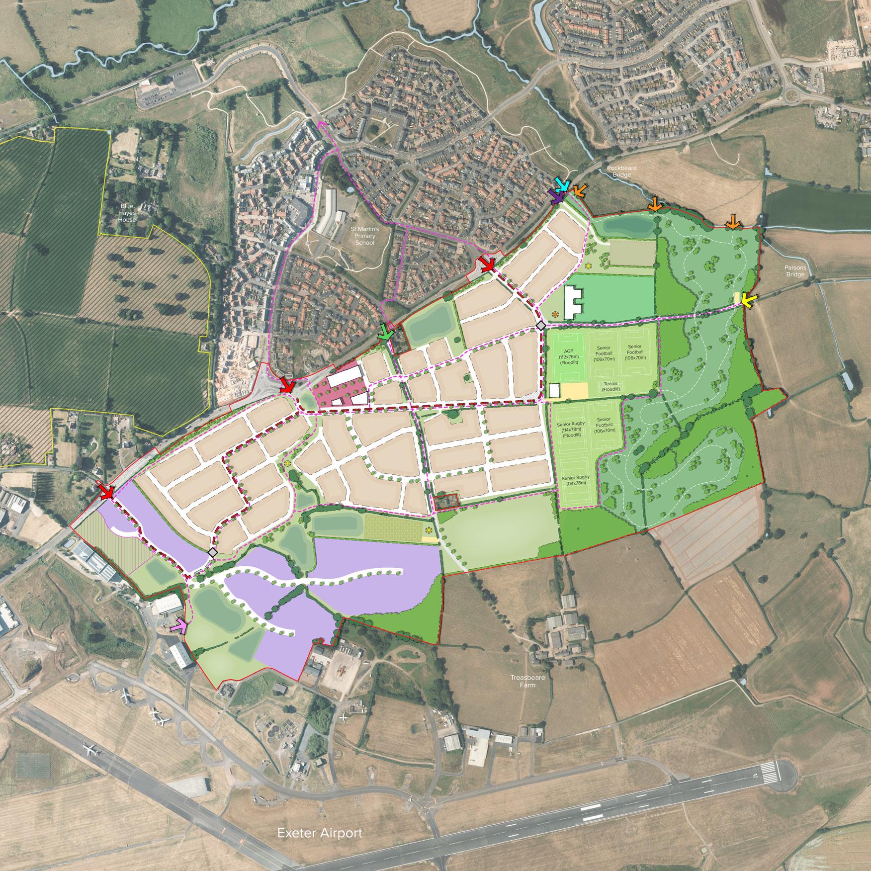
Treasbeare Garden Village lies to the south of Cranbrook, forming part of a wider strategic development area in accordance with local policy.
Working with a team of consultants, a Design & Access Statement was prepared on behalf of a consortium of national housebuilder clients to support an Outline Planning Application for:
‘Up to 1,035 residential dwellings; a neighbourhood centre with a maximum of 3,000sq.m gross of ground floor space (Use Class E); a two form entry primary school, with early years provision (Use Class F1); public open space, including formal open space, formal play space, allotments, amenity open space and SANGS land; a sports hub comprising playing pitches, tennis courts, a multi-use path and a pavilion (Use Class F2); up to 10.25ha of employment land (Use Classes E(g), B2 and B8); 5 serviced pitches for gypsies and travellers; an extension to the existing Cranbrook Energy Centre; sustainable drainage systems; and associated infrastructure. All matters are reserved for future consideration aside from access.’
36
10
Treasbeare Garden Village Illustrative Masterplan
LONDON ROAD (B3174)
Parsons Lane
Treasbeare Lane
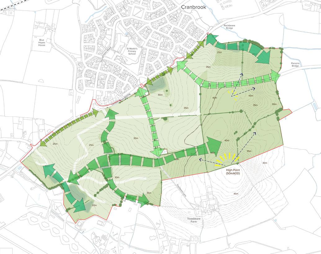
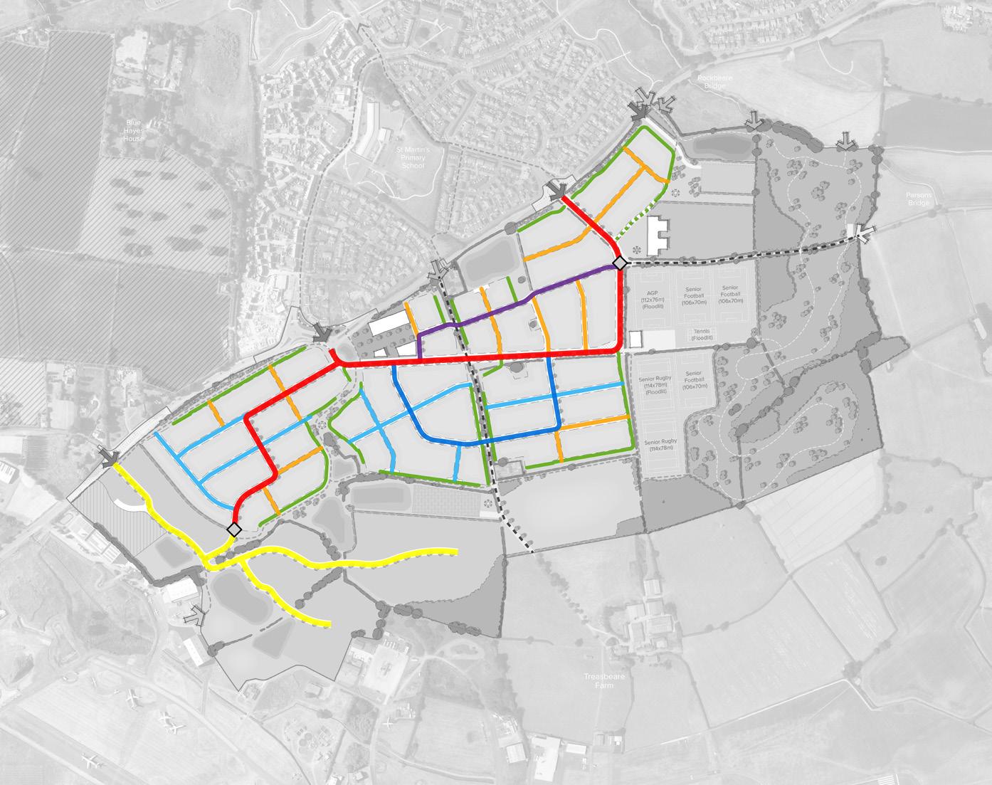
The structure and character of the masterplan has been shaped by the topography of the site and its relationship to existing and future development. Established landscaped features have been retained and integrated within parks, green corridors, and informal green spaces. Open spaces are located on higher grounds to the east with views over Cranbrook and the wider countryside to promote legibility and identity whilst preserving the wider setting to Rockbeare and Whimple. And developable land is maximised within a coherent grid arrangement to ensure safe and convenient movement to local destinations.
The Vision has been shaped by a framework of ‘garden city’ principles, which aim to bring forward a holistic settlement extension that enhances the natural environment and offers high-quality affordable housing and locally accessible work in beautiful, healthy and sociable communities.
37
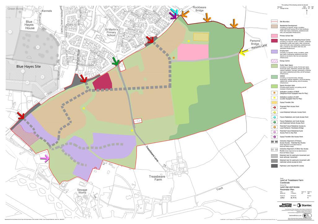
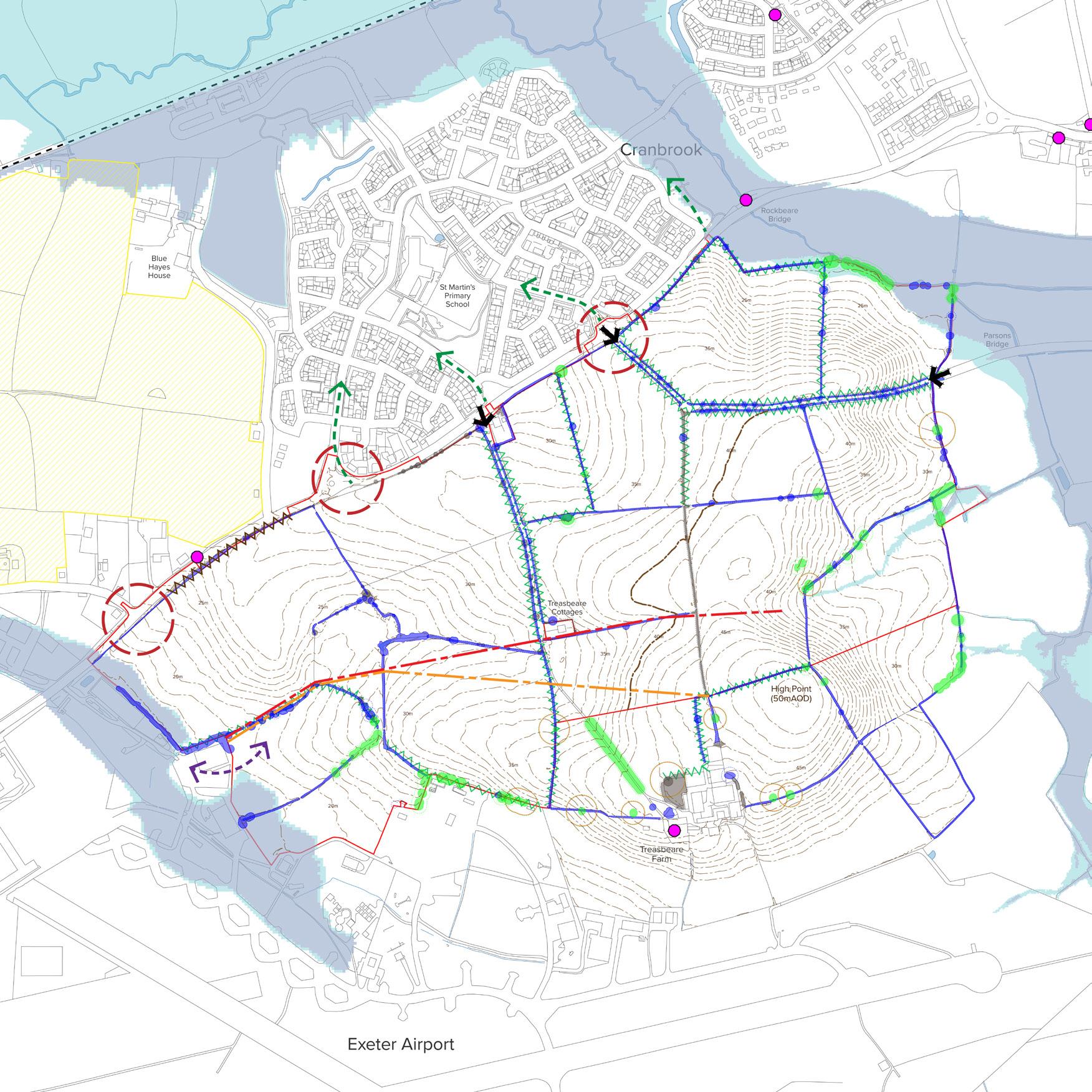
Treasbeare Garden Village Constraints & Opportunities Plan
Treasbeare Garden Village Land Use & Access Parameter Plan
Areas of development will be divided by a cruciform of ‘key green/blue corridors’ that are defined by existing landscape features and enhanced to deliver biodiversity gains, strategic movement routes, and accessible open spaces that will provide civic amenity.
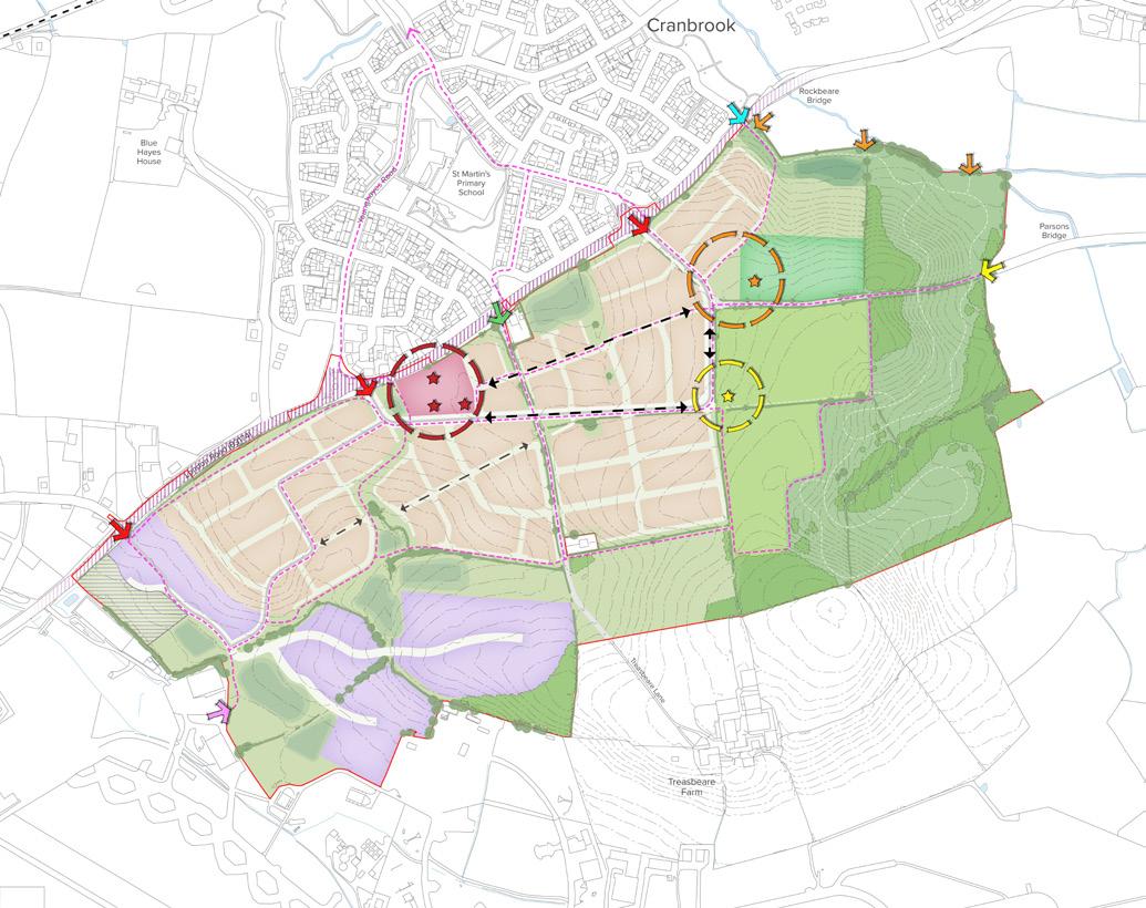
Creating Places & Spaces
A coherent arrangement of links and nodes will establish a compact and connected urban form that informs the creation of new community places and provides legible connections to local destinations.
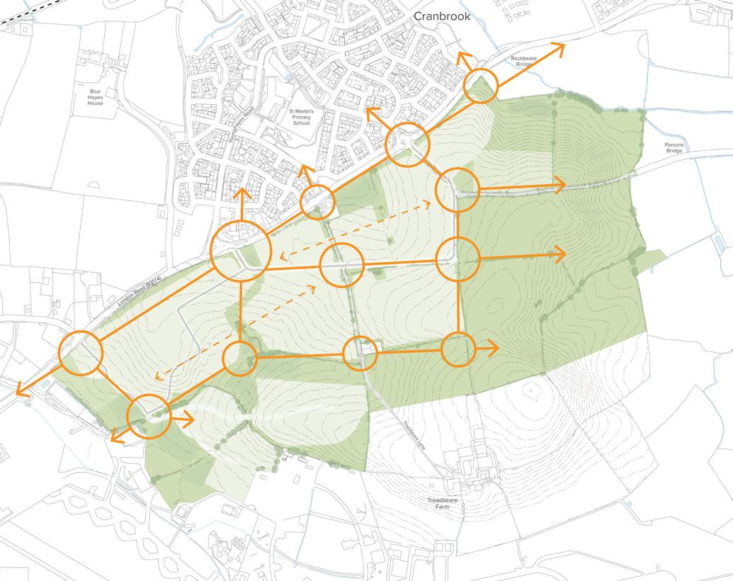

A series of interconnected places and spaces will bring benefits to the community, designed to have a role and function within the development. The Neighbourhood Centre is located to ensure that it is well placed commercially and also acts as an exciting and active gateway to the new development. The School is located near to the development’s main eastern access and primary movement route, and co-located with the Sports Hub to form a transitional edge between development and open spaces. The compact and connected urban form will encourage active and sustainable travel choices to these key community places.
38
Connected Green Infrastructure
Linking the Community

39
Illustrative Layout
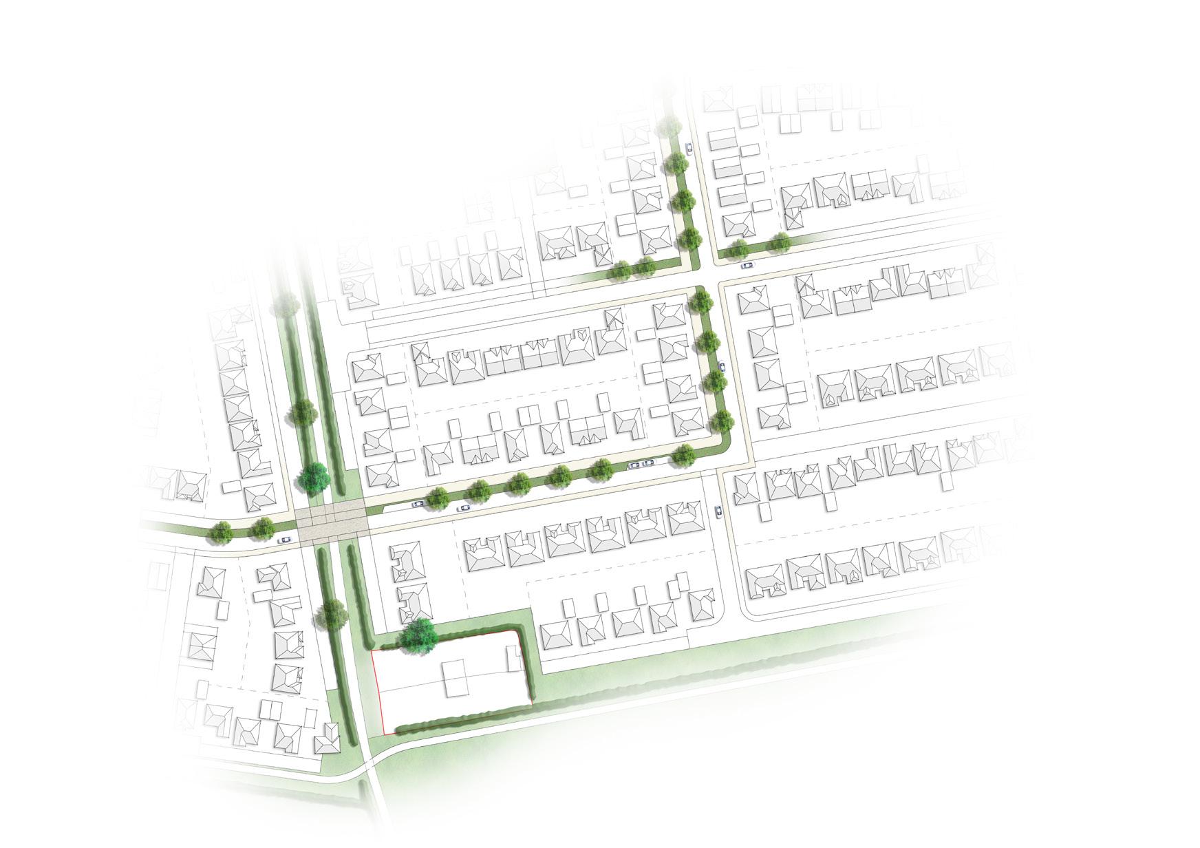
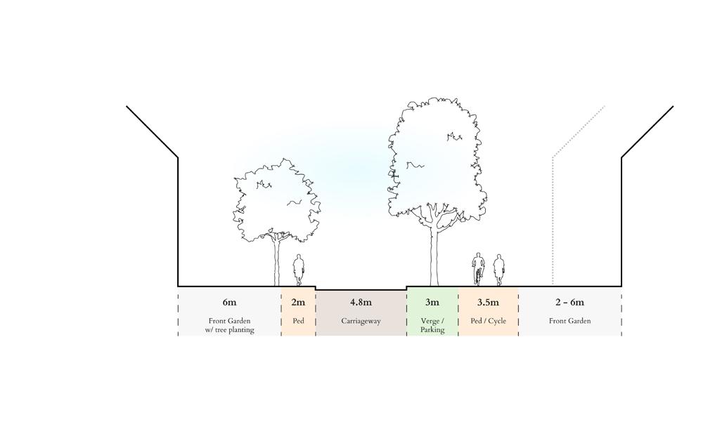
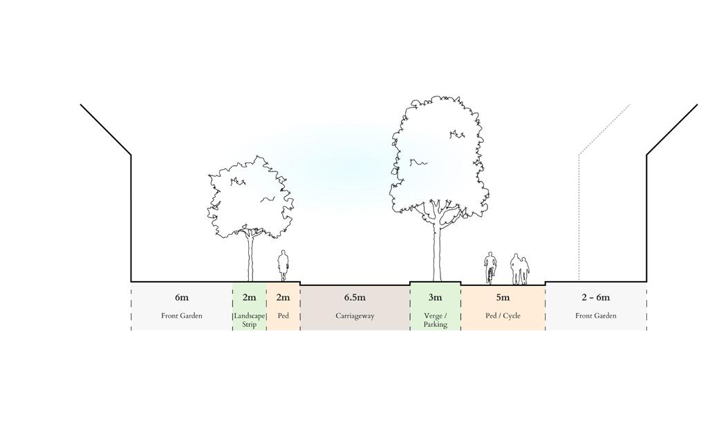
Treasbeare Garden Village Street Hierarchy Plan
‘Secondary Street B’
‘Primary Street’
NEWBRIDGE POINT
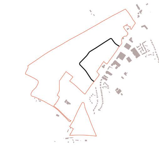
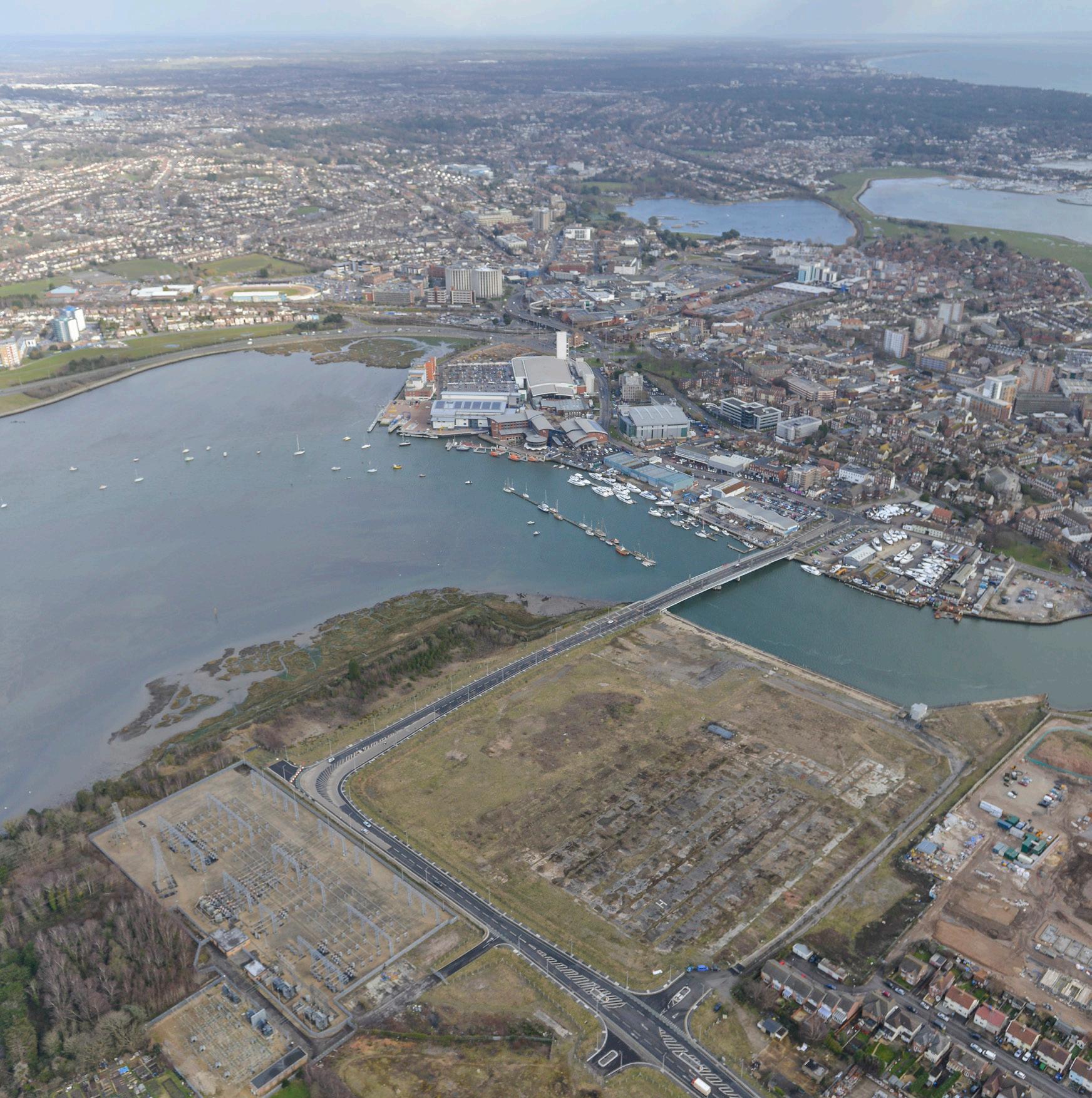
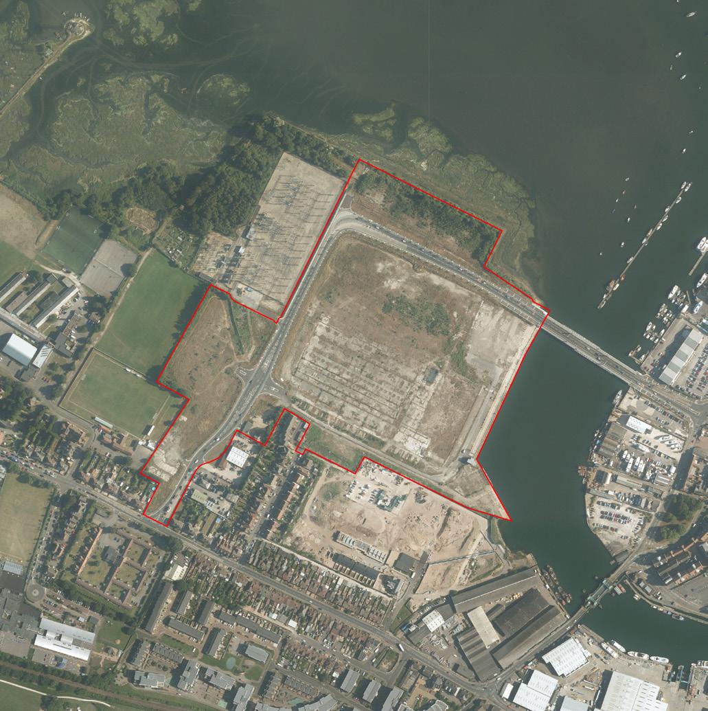
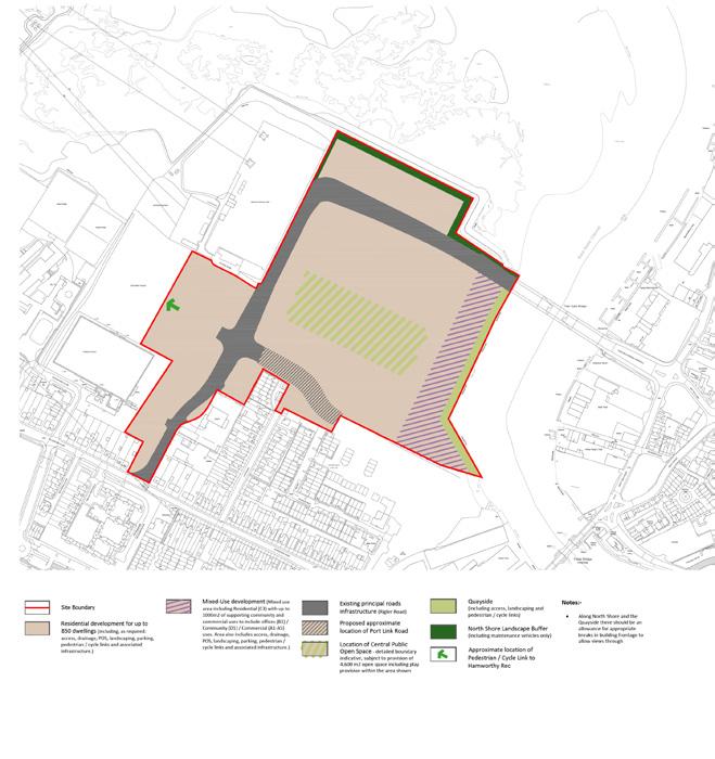
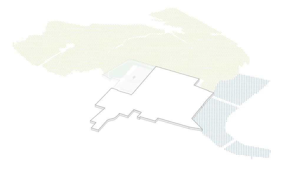
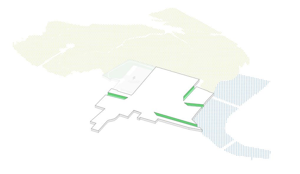
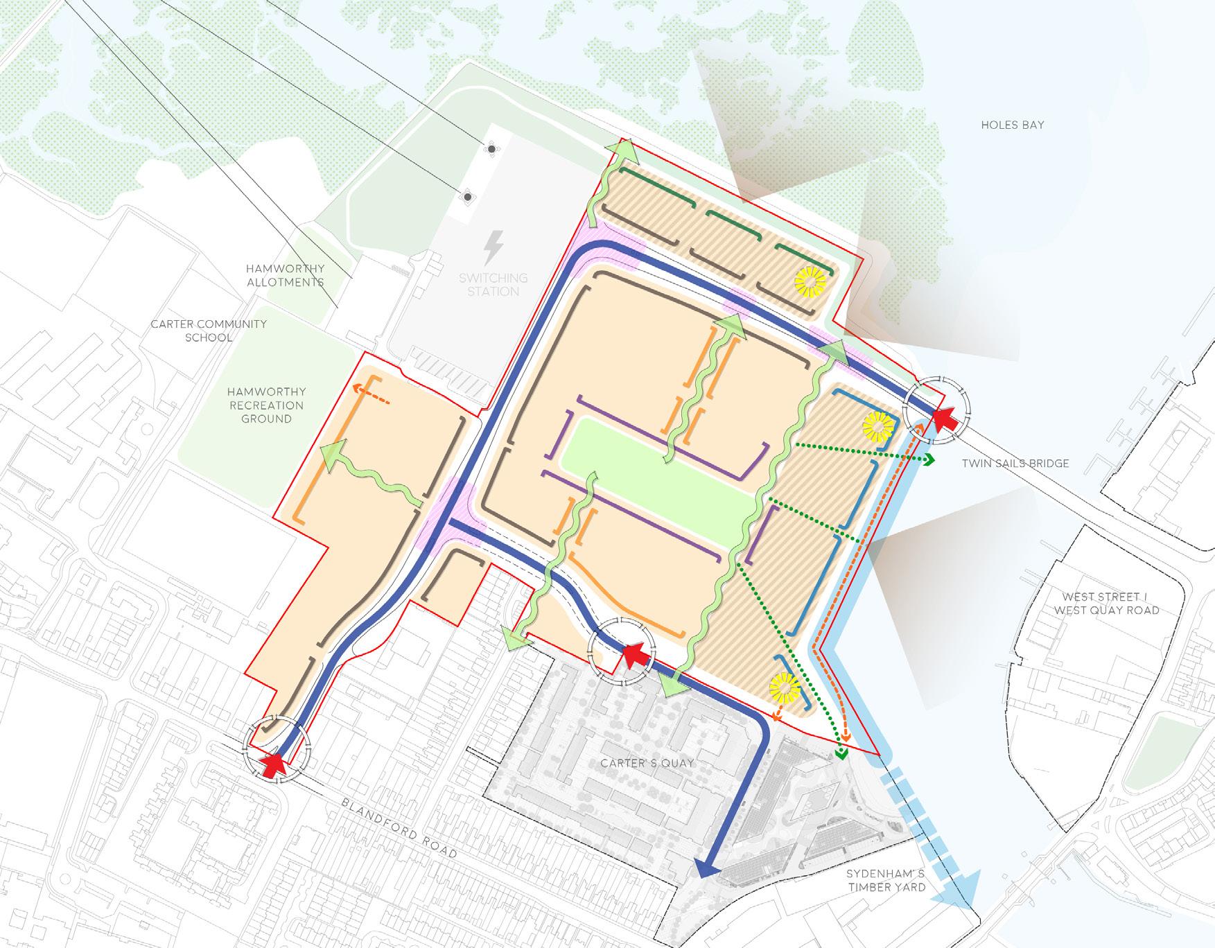
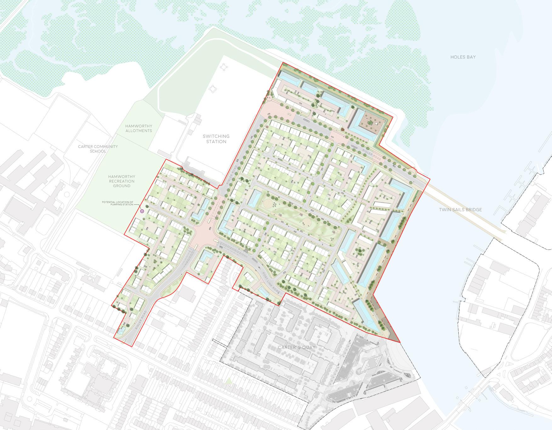
Dorset, UK | Outline Planning Application
Newbridge Point is situated on reclaimed land within Poole Harbour, encouraged for redevelopment by the local authority. Working with a team of consultants, a Design & Access Statement was prepared on behalf of a land promoter client to support an Outline Planning Application for: up to 850 new homes; up to 1000sqm of supporting community and commercial uses; landscaping and public open space including children’s play space; new pedestrian and cycle links (with all matters reserved); and associated highways works including car parking, associated infrastructure, and associated earthworks.
40
11
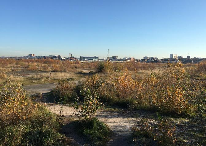
Newbridge Point
Site Photo
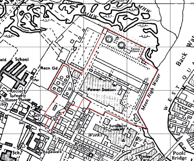
The Site comprises approximately 14ha of open hard-standing reclaimed land, formerly used as a power station and oil depot. Its unique location has an extensive and varied shoreline, with the Holes Bay (Ramsar Site) to the north, and Backwater Channel with views of the Poole Town Centre to the east.
Newbridge Point is a major regeneration opportunity for Poole, but is complicated by challenging environmental and technical constraints, including the ecological sensitivity of the natural setting, contaminated and potentially unstable ground conditions relating to its former uses, and viability concerns due to expensive remediation costs.
41
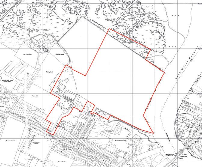
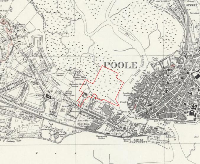
on Historic Map (1938)
on Historic Map (1955)
on Historic Map (1975)
Site
Site
Site
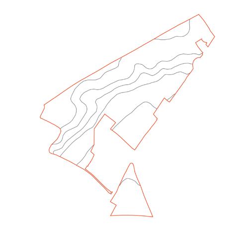
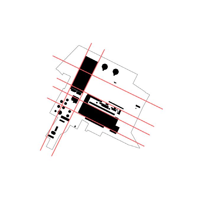
Newbridge Point Site Plan
Newbridge Point Land Use & Access Parameter Plan
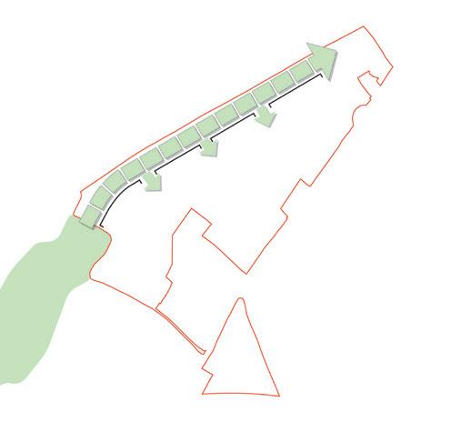
Re-seeding the bay
Inspired by its unique natural setting, an appreciation of its heritage, and its connections to existing neighbourhoods, a key design objective for the site was to facilitate a dynamic integration of the natural and urban environments, characterised by accessible new green spaces and a special architectural language.
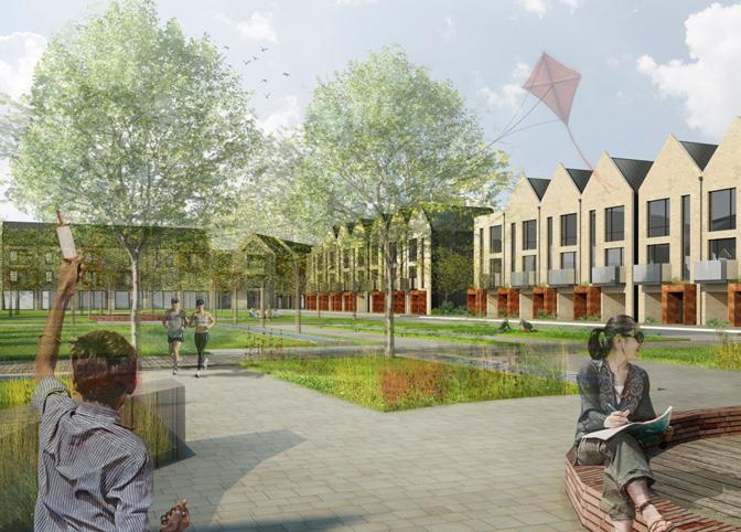
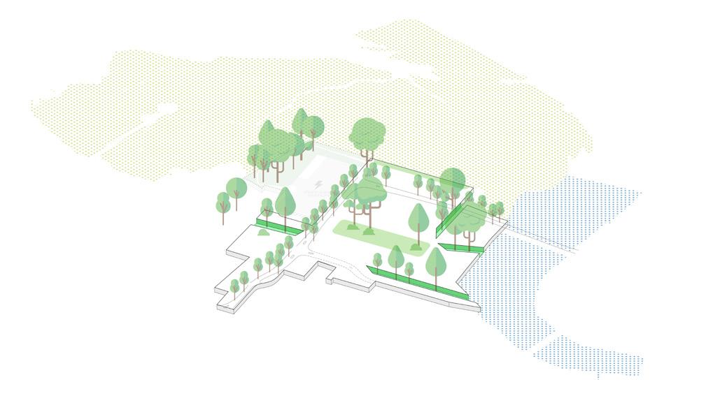
The former power station and oil depot were arranged in an orthogonal manner, with remnant foundations left behind. To recognise the site’s industrial heritage, this arrangement was incorporated into the design response and informed the creation of a new central open space that would playfully retain the remnant foundations in the landscape design.
42
43
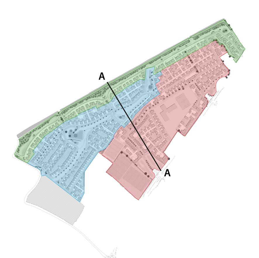
Newbridge Point Concept Plan
Newbridge Point Illustrative Masterplan
OTHER WORKS
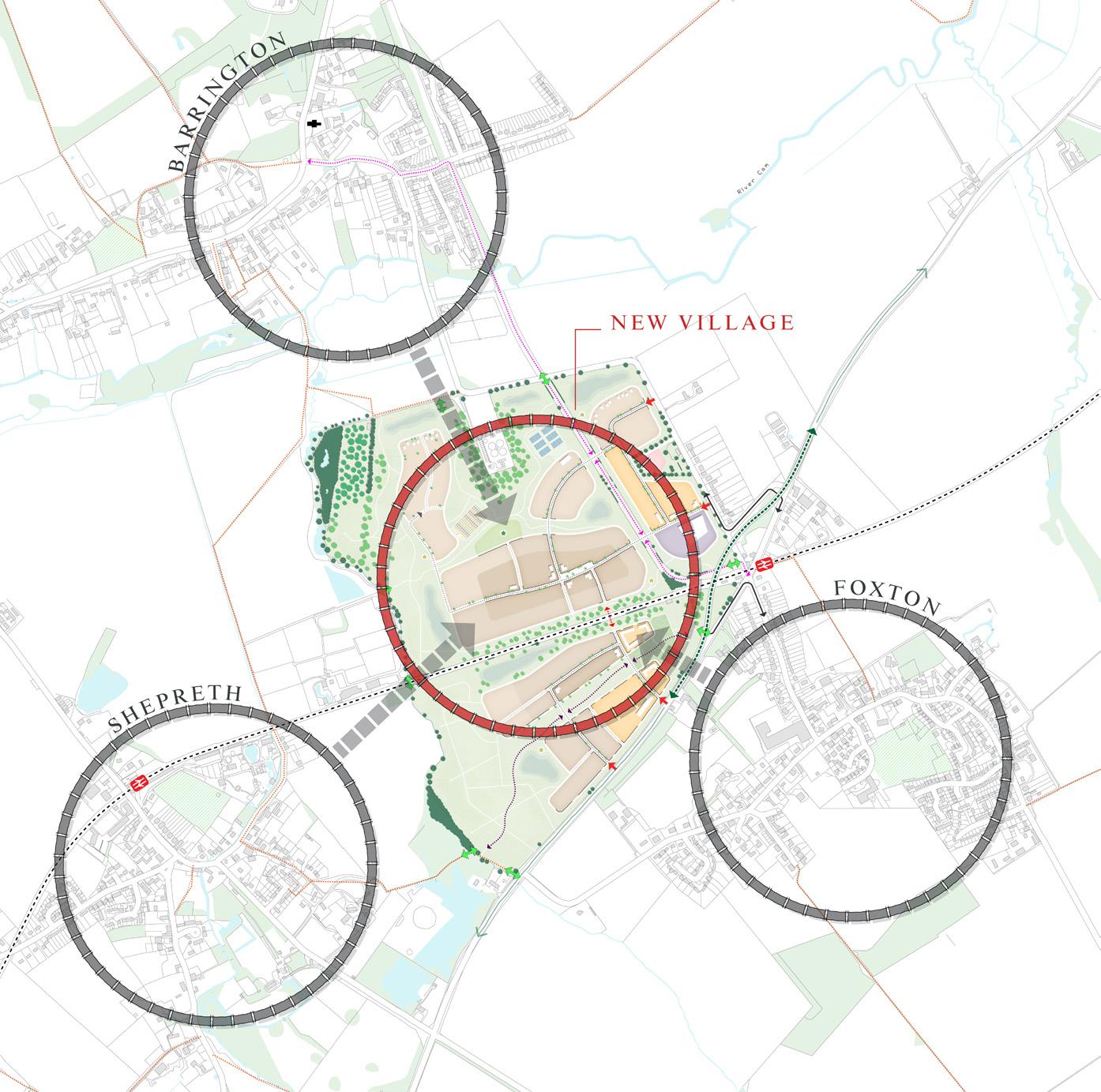
Station Fields | Site Promotion
Station Fields lies within a cluster of villages in South Cambridgeshire, and an important strategic location relative to future infrastructure investment in the Greater Cambridge Area. The development of a ‘new village’ at Station Fields would deliver approximately 1,500 new homes to help meet local demand and enable a coordinated delivery of strategic transport improvements and new facilities that would benefit the wider community. The proposed approach is to create a new community that is well connected to, but physically separate from, the existing villages.
44
12
Station Fields Concept Plan
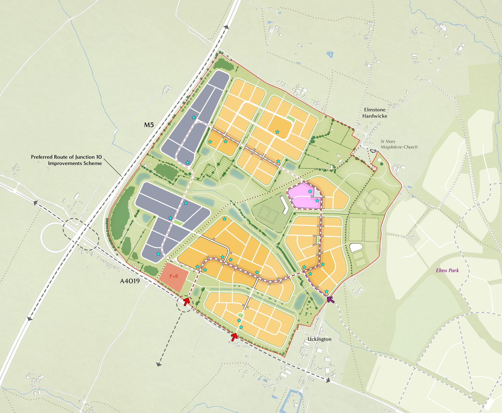
Elms Park West | Site Promotion
Elms Park West lies to the north west of Cheltenham, on land safe-guarded for future development under local policy. Planned improvements to Junction 10 of the M5 are set to unlock this opportunity, which will ensure that there is sufficient highway capacity to accommodate the increased motorised and non-motorised traffic it will generate. The concept shows an emerging spatial framework for the delivery of a sustainable, net zero carbon, contemporary new mixed-use community that would provide up to 2,500 new homes, significant employment opportunities, education and leisure facilities, commercial uses, and a park and ride. Its compact urban form and connected grid arrangement will establish a permeable development, structured around distinctive existing features, such as the Leigh Brook, and responding to the setting of local landmarks, such as the Grade II* listed St Mary Magdalene Church.
45
Elms Park West Concept Plan
Ashton Vale | Site Promotion
Ashton Vale lies to the south west of Bristol within North Somerset, approximately 5km from the Bristol City Centre. Working with a team of consultants, various documents and presentations have been prepared on behalf of the client to support the Site’s promotion through engagement with the local authority and key stakeholders over several years. The design concept has addressed key issues raised through the engagement process, and takes inspiration from the land and its setting. The development areas are arranged into a collection of three new village communities, which responds to the rural settlement characteristics of North Somerset. The slightly disbursed urban areas will be defined and contained by the landscape structure of the Site, with facilities and services provided within each village centre to ensure residents can easily and sustainably access everything they need, such as food shops, leisure activities, workplaces and education. Recently, a large part of the Site has been allocated for development, highlighting a successful site promotion process.
46
Ashton Vale Illustrative Masterplan
Payne’s Shipyard | Site Promotion
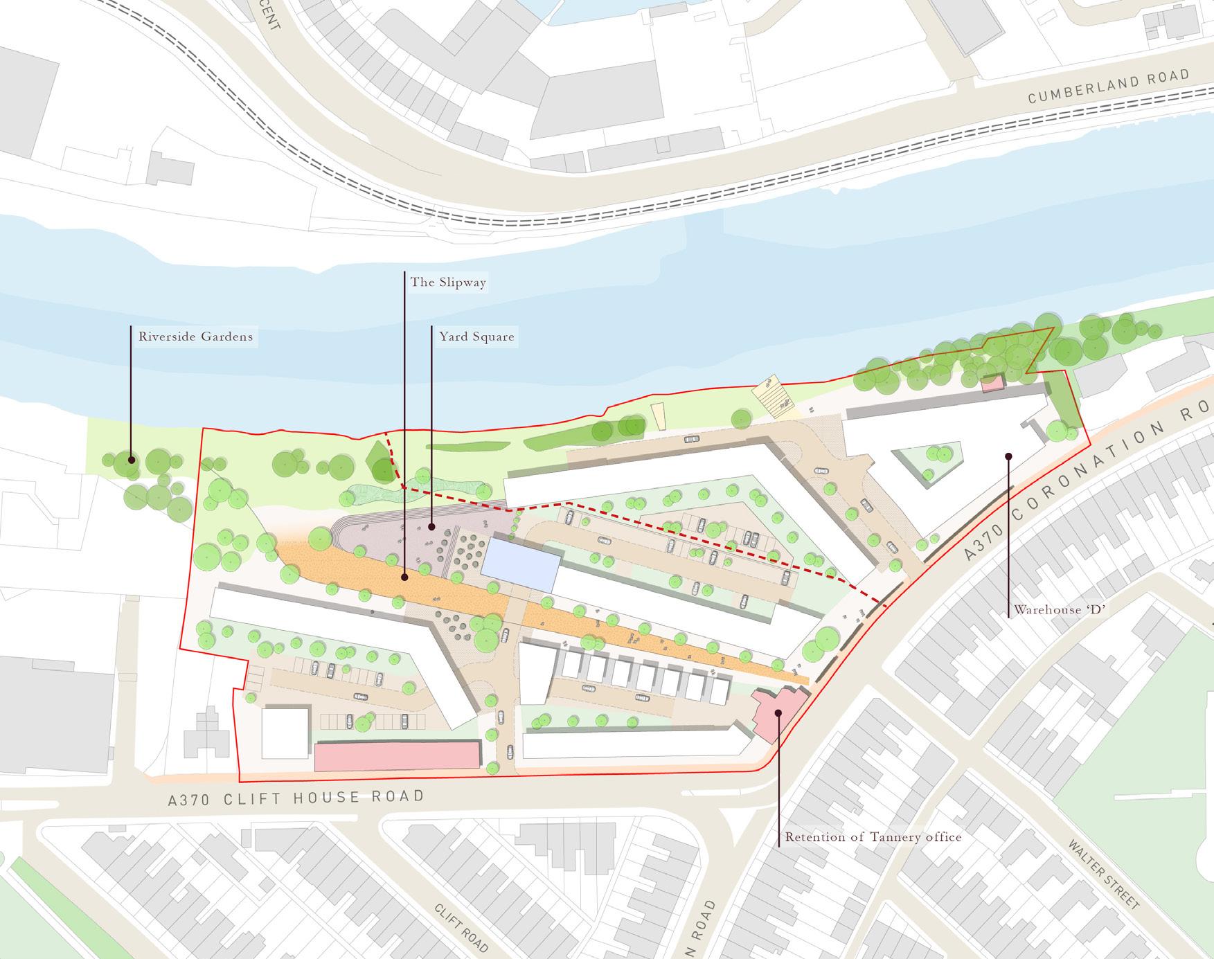
Payne’s Shipyard lies to the west of Bristol City Centre and provides the opportunity to deliver up to 200 new homes through the redevelopment of brownfield land. The Site has been a private walled area for over 100 years, with no physical or visual connections through it. The Site’s industrial heritage, its waterfront location, and its relationship with existing neighbourhoods, have inspired a design approach that would re-connect the Site back into the city. The concept would include: enhanced public access to the river; visual connections to local landmarks; new community work spaces; and the preservation of historical and natural features within vibrant public spaces that encourage social activity.
47
Payne’s Shipyard Concept Plan