3.0 Post Referral – Further Work
Armstrong Creek Investigation Areas
3.1 FurtherWorkVisualAnalysis
In its referral response to the updated background report, DTP raised a number of matters for further consideration. This included the need for a visual impact assessment to confirm any new development in the ‘Mount Duneed and Surrounds’ regionally significant landscape did not detrimentally impact the landscape and green break values identified in the Surf Coast Statement of Planning Policy (SPP).
Post receipt of this advice officers re-engaged Echelon in late 2023 to assist with the landscape assessment work. Consultants Pointalism, assisted by Beverage Williams, commenced in early 2024 with a report completed in May 2024. Echelon have analysed the work completed by Pointalism and prepared an addendum to the Background Report which sets out findings and recommendations.
3.2 VisualAnalysisFindings
The Pointalism visual analysis work is an appendix in the Echelon addendum to the background report.
The two key findings out of the visual analysis are:
55 & 75 Williams Road (Purdies Paddock) is included in the settlement boundary.
10-40 Williams Road is not included in the settlement boundary.
These findings were reviewed by officers prior to a decision being made on the location of the longterm settlement boundary.
4.0 Final Recommendations
There are 4 recommendations to come out of the review that result in changes to existing conditions. Three relate to changes to the boundary (Sparrovale, Moolap and Armstrong Creek South- West investigation areas) and one relates to a land use change outside the boundary (Armstrong Creek South West and South Central investigation areas).
4.1 SparrovaleInvestigationArea
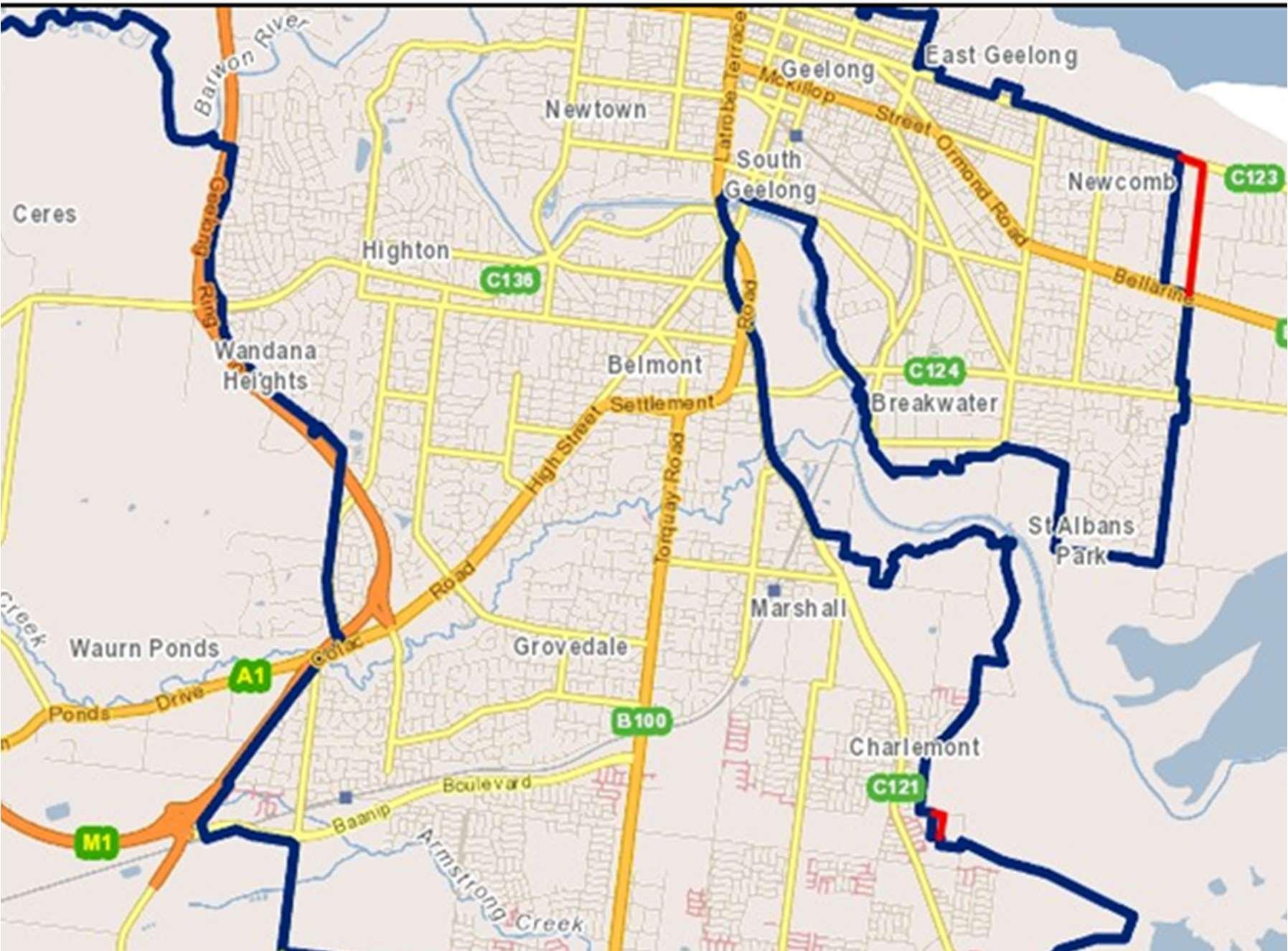
There is a recommendation to extend the boundary to include 145-153 Harriott Road shown in figure 1 below (existing boundary shown in blue, proposed boundary shown in red):
Figure 1 - Existing(blue) and proposed (red) settlement boundary. Source: CoGG
Summary of support for the recommendation:
This minor adjustment to the boundary (one additional lot of ~2.3ha) is contiguous with existing urban land (assessment guiding principle 2).
The land can rely on existing services without creating additional need (assessment guiding principle 5).
Barwon Water have indicated infrastructure delivery benefits if the land is developed that could support development in the existing urban growth zone (assessment guiding principle 4).
Subdivision of this site into larger residential allotments would provide an improved transition between the urban growth and farming zoned land which currently proposes a solid boundary fence.
While Harriots Road itself would make a more logical boundary the flood levels on the other 3 lots means they are not developable. The CCMA have been consulted on the proposal to include this site and did not object subject to conditions.
Of the remaining 3 landowners one noted they were happy to be rezoned or left as farming zone and two landholders did not make a submission.
Given the minor nature of this proposal, this land could be rezoned as part of the boundary review amendment rather than require a separate amendment. A residential zone with design guidance would ensure adequate controls are in place for subdivision.
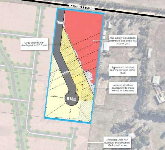
The submission included a proposed layout and a high-level assessment of servicing and other considerations:
Eighteen lots varying in size, offering a transitional density between Haymont estate and the land to the east (see figure 2 below).
A 16m road reserve from Harriott Road and terminating at a court bowl.
All lots provided with adequate area to construct a dwelling and associated outbuildings above the land subject to inundation.
The land subject to inundation and flooding utilised as secluded private open space of adjacent lots.
Minimal fill on the boundary with 135 Harriott and limited to the rear of the property, achieving an urban design outcome that respects neighbouring properties.
Provides a better transition between urban and farming land uses.
Figure 2 – Potential subdivision layout submitted by the landowner with consideration given to flood levels. Source: landholder submission
Barwon Water have indicated they do not object to this lots’ inclusion. They also note there could be benefit to a through road (on proposed site) for infrastructure installation connecting to the court bowl in the urban growth zone (shown in figure 2 above). This can be investigated as the proposal moves forward.
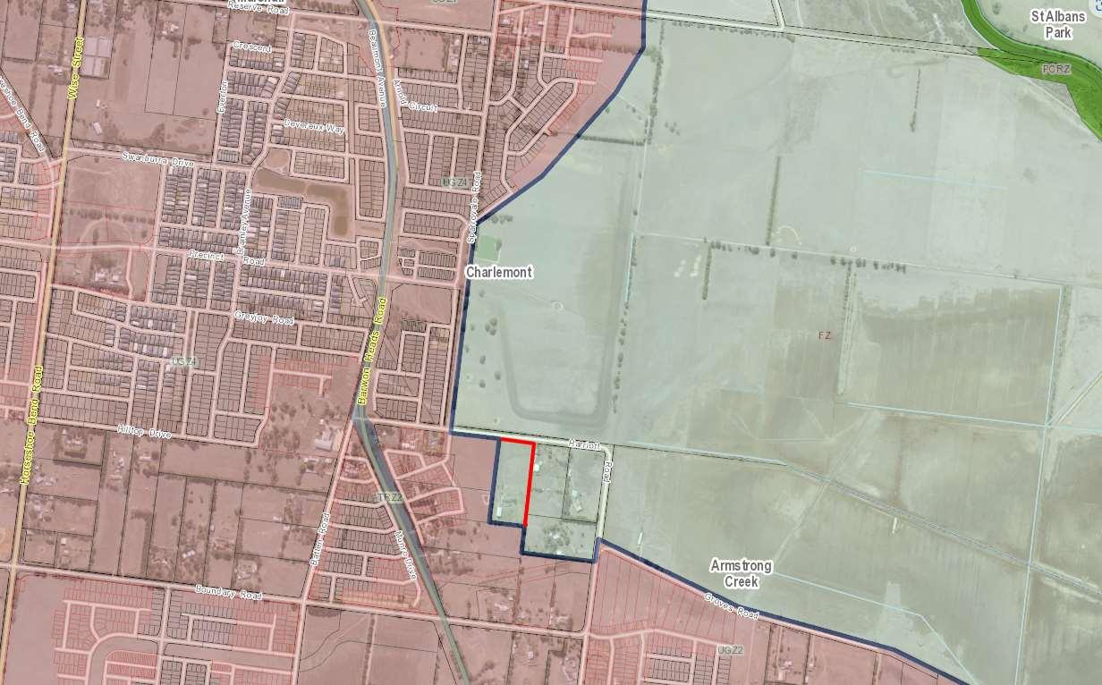
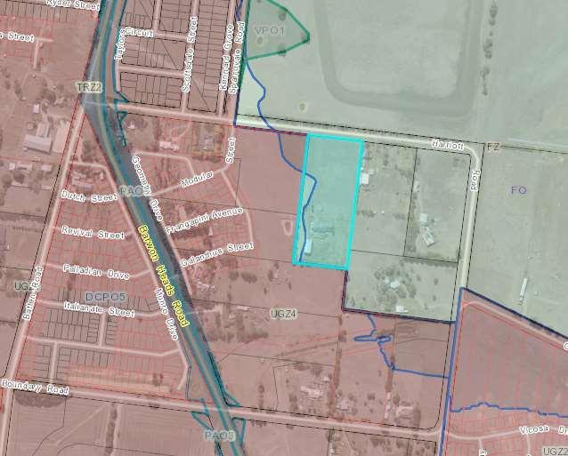
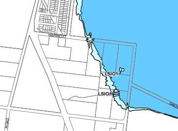
The lot was previously subject to the Flood Overlay (figure 3 below) and thus was excluded from the urban area under the original Armstrong Creek Framework Plan. Under amendment C339 part 2Flood overlays (Lower Barwon and Moorabool rivers and Bellarine Peninsula Coastal Hazard) the flood overlay extent has been revised down on the subject land (figure 4).
Figure 3 – Subject site (blue outline) showing former extent of existing Flood Overlay prior to January 2024. Source: CoGG
Figure 4 – Current extent of the LSIO (light blue) and FO (dark blue) on the Farming Zoned lots on Harriott Rd. Source: GG planning scheme.
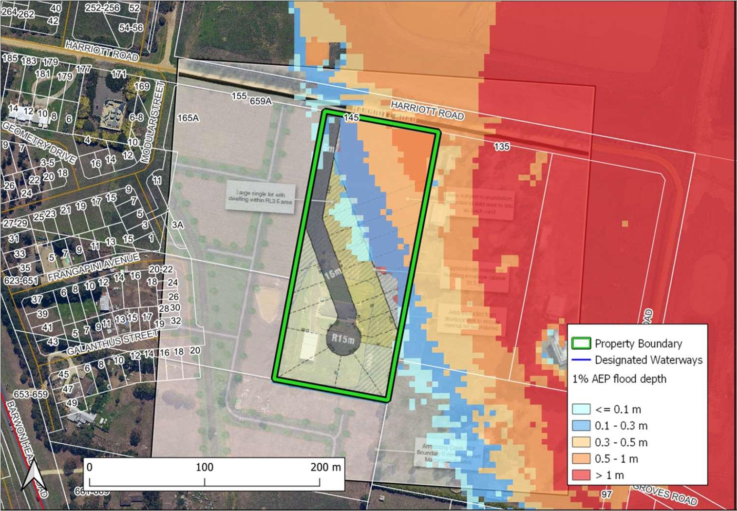
ThesubmissionwasreferredtotheCorangamiteCatchmentManagementAuthority(CCMA)who usedtheproposedsubdivisionlayoutandoverlayedthe1%floodlevel(seeFigure5below).The CCMAdidnotobjecttothispropertybeingincludedwithinthesettlementboundaryand recommendedconditionsfortheconceptuallayout.
Figure5-Subjectproperty(greenoutline)showingtheapplicable1%AEPfloodextentandproposed lotlayout.Source:CCMA
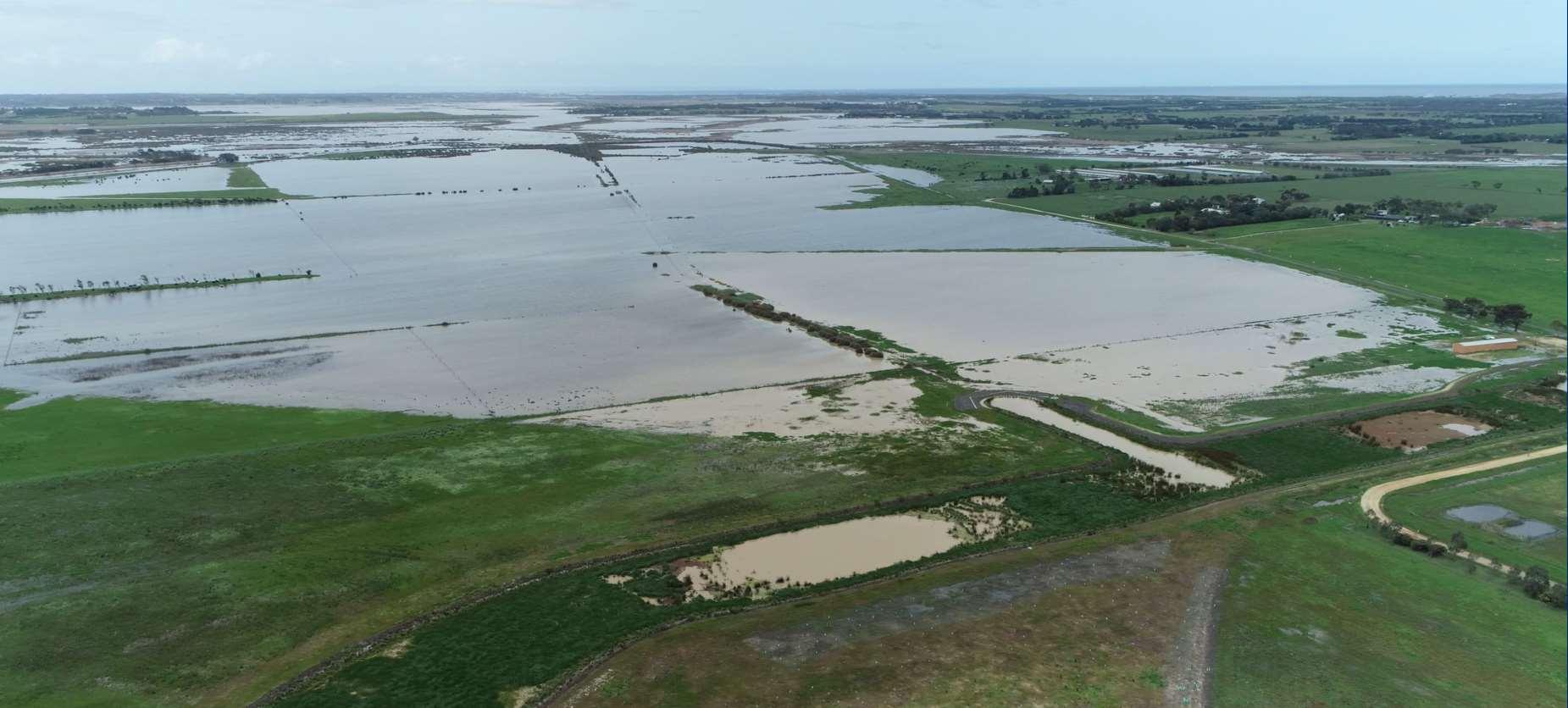
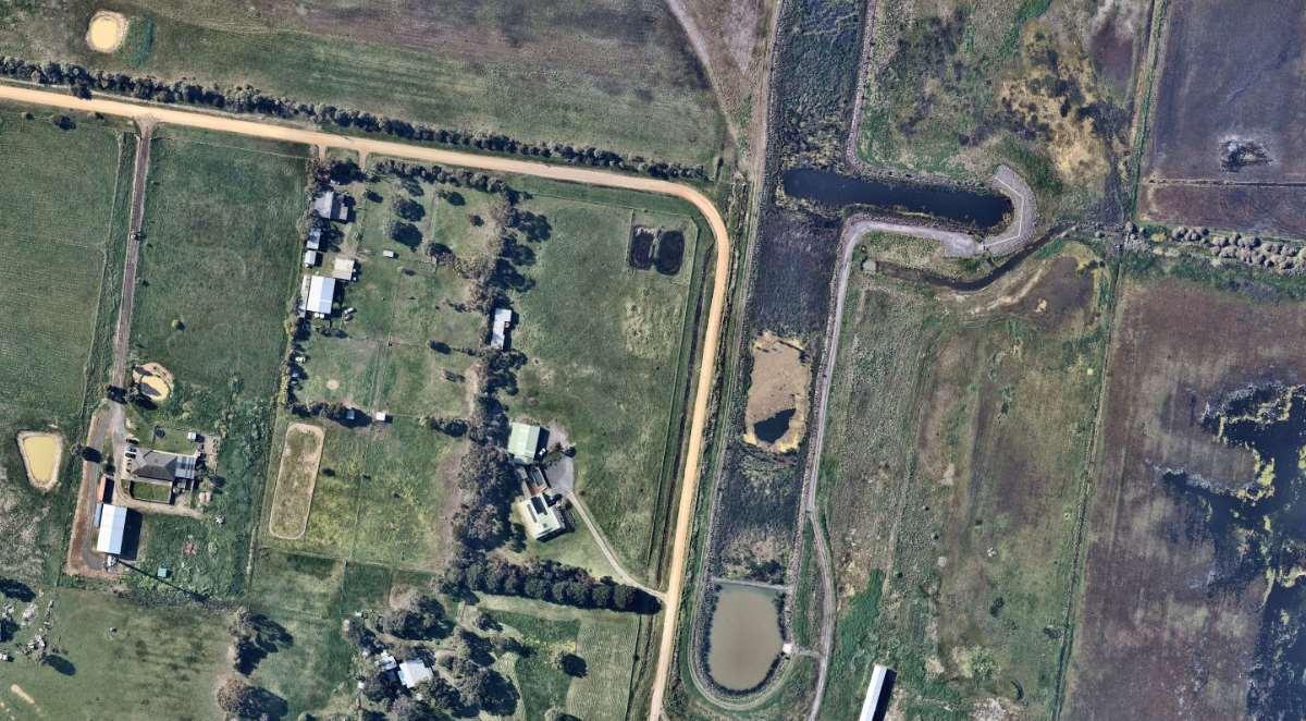
TheimagebelowwastakenduringthehighrainfalleventinNovember2022.Thefloodingdidnot extendbeyondtheSparrovalewetlands(bluearrow)toHarriotsRoad(markedwiththeorange arrow)duringthisfloodevent.Thesubjectsiteisshownwiththeredstaronfigure7.
Figure6–Floodeventin2022showingwatersremaininginSparrovalewetland.Source:CoGG
Figure 7 – Aerial image showing location of subject site (redstar) in relation to Harriott Roads (orange arrow) and flood waters (blue arrow) in Figure 6 above. Source: CoGG
The DTP response indicated there is a lack of strategic justification to include this land within the Settlement Boundary. There is reference to the Bellarine SPP which has the boundary in this area nominated as a green break of regional significance (as is all Farm Zone land in the declared area). The boundary is nominated in the SPP as ‘indicative subject to further work’, the further work being this boundary review.
An assessment against the Bellarine SPP has been carried out below:
Aboriginal cultural heritage – Wadawurrung Country
Objective 1: To conserve, strengthen and promote the declared area’s Aboriginal cultural heritage values and partner with the Wadawurrung to care for Country.
Response
In their response to the draft Background Report the Wadawurrung indicated they want no change to the existing boundary. No response was provided to the updated Background Report. This proposed minor inclusion does not include any known areas of cultural heritage sensitivity including registered Aboriginal cultural heritage places or landforms and land categories that are generally regarded as more likely to contain Aboriginal cultural heritage. The planning scheme amendment/subdivision application will be referred to the Registered Aboriginal Party for comment including any Cultural Heritage Management Plan requirements. The site currently contains a dwelling and farming activities.
Environment and biodiversity
Objective 2: To conserve and enhance the significant biodiversity, ecological and environmental values of the declared area.
Response
The property to be included is currently zoned and used for farming and does not contain any significant biodiversity. Any future subdivision would be subject to vegetation provisions in the
planning scheme. Stormwater can be managed on-site due to the size of the proposed lots and planned infrastructure and CCMA were supportive subject to conditions.
Landscapes
Objective 3: To protect and enhance the identified landscape character, physical features, view corridors and natural and cultural values of the declared area’s significant landscapes.
Response
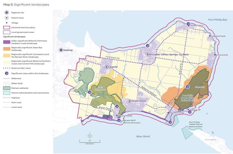
Under the Bellarine SPP the land is located within the regionally significant landscape area:
Central Bellarine Hills landscape area
Covering the whole central and northern area of the Bellarine Peninsula, the Central Bellarine Hills landscape area is characterised by terrain that is gently undulating to hilly. Its high points include Mount Bellarine (also known as Murradoc Hill and which is the most dominant topographic rise in the north), Scotchmans Hill and Marcus Hill. The landscape area forms a backdrop to many settlements and offers expansive views of the coast and beyond. The hilly landscape interfaces with the coast with prominent slopes to Lake Connewarre and a steep escarpment overlooking the Bass Strait coast at Ocean Grove. There is a discernible, steeper edge to the landscape area in the north near Portarlington and Clifton Springs as it meets the coast. Before colonisation, the area would have supported a complex woodland community: now, only pockets of remnant native vegetation remain in small clusters, including those adjacent to waterways and along roadside reserves. The balance of the land is a cleared, agricultural patchwork of paddocks and planted windbreaks, with some exotic trees around homesteads and vineyard plantings.
Figure 8 below shows the extent of the Central Bellarine Hills area in yellow.
Figure 8 – Significant landscapes map, Bellarine SPP. Source: Bellarine SPP
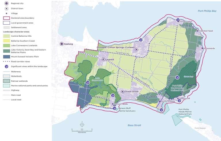
This description does not relate to the land west of Lake Connewarre. This is further demonstrated by the Landscape Character Area Map (figure 9) which nominates this area as part of the Mount Duneed Volcanic Plain rather than the Central Bellarine Hills area.
Figure 9 Landscapecharacter area map, Bellarine SPP. Source: Bellarine SPP
The Surf Coast SPP contains the Mount Duneed Plains and Surrounds regional landscape of significance which also has the landscape area ‘Mount Duneed Volcanic Plain’, arguably this is the landscape that should apply to land west of Lake Connewarre in the Bellarine SPP.
The Surf Coast SPP describes this landscape as:
The Mount Duneed Plain and Surrounds is a flat-to gently-undulating landscape formed by volcanic flows of basalt. It includes the low, volcanic rise of Mount Duneed itself, with its unique geology and communities of grasslands. It also includes Thompson Creek, which winds its way from the coast at Breamlea, its upper and middle reaches cutting a pathway through the patchwork of paddocks that characterise this agricultural landscape. Remnant eucalypts are a further feature of this landscape, found in riparian reserves, adjacent to road corridors and scattered throughout paddocks. They contrast with the mostly exotic, lineal shelterbelt planting. This is an open, expansive landscape of long, straight roads under big skies. It is a very important green break between the built-up areas of Geelong and Torquay and the settlements of the Bellarine Peninsula.
The proposed inclusion does not detract from the landscape or green break values identified in the Bellarine or Surf Coast SPP. No identified views or view corridors are impacted. The green break in this area is preserved in perpetuity due to the presence of flood overlays and public parks and reserves on land adjacent to the existing urban growth zone precinct. This lot is the only lot capable of development before flood levels rule further urban expansion out. The inclusion of lower density lots offers a better transition than the current planned urban-farming transition. It is also consistent with the Surf Coast SPP objective to consider the design and density of development in urban-rural
transition areas within the protected settlement boundary that support the regionally significant landscape setting.
Environmental risks and resilience
Objective 4: To achieve a zero-carbon future and support the resilience of the declared area’s distinctive attributes by taking sustained measures to reduce greenhouse gas emissions, mitigate climate change and natural hazards risks and adapt to their impacts.
Response
The proposal is responsive to the latest flood mapping and is supported by the CCMA.
Historic heritage
Objective 5: To protect, strengthen and promote the declared area’s post-colonial historic heritage values.
Response
Not applicable.
Tourism, agriculture and natural resources
Objective 6: To enable a diverse, sustainable and strong regional economy (including responsible tourism, agriculture and natural resource industries) that protects and promotes the declared area’s landscape significance, environment and biodiversity, agriculture and Wadawurrung living cultural heritage and historic heritage values.
Response
The proposal has no impact on tourism or agriculture. This property is one of four ~2ha lots which are more akin to lifestyle rather than farming properties. Map 7 in the SPP shows the site is covered by the Extractive Industry Interest Area however the proximity of urban development, flood risk and the location of RAMSAR wetlands means it is unlikely to ever be used for extractive activities.
Strategic infrastructure
Objective 7: To ensure the integrated provision and protection of transport, strategic water assets, essential services and community infrastructure that meets the community’s needs while increasing resilience to climate change.
Response
There are no impacts on strategic infrastructure. The inclusion of one 2ha property (potential ~18 lots when subdivided) means the development can rely on existing infrastructure without putting pressure on existing and planned infrastructure, services or facilities.
Settlements
Objective 8: To plan and manage the sustainable development of settlements in the declared area consistent with the protection of the area’s landscape significance, environment and biodiversity values, Wadawurrung living cultural heritage and historic heritage values and consistent with the unique character and hierarchy designation of each settlement.
Response
The proposal provides a superior transition within the settlement boundary from the urban area to the Farming Zone and Public Conservation and Resource zone.
Conclusion
The additon of this lot into the settlement boundary provides a superior urban-rural transition and potential infrastructure delivery benefits.
The additon of this lot into the settlement boundary will not detrimentally impact the greenbreak.
The addition of this lot will not create pressure for further consolidation or boundary expansion due to the environmental constraints of the area.
4.2 MoolapInvestigationArea
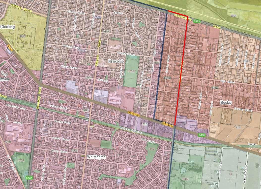
There is a recommendation to extend the boundary to include the area between the existing settlement boundary and Coppards Road in Newcomb (existing boundary shown in blue, proposed boundary shown in red in figure 10).
Figure 10 –Existing boundary (blue) and proposed boundary (red) in Newcomb. Source: CoGG
Summary of support for the recommendation:
The land is zoned Low Density Residential Zone (LDRZ) which is an urban zone and the area is contiguous with the Newcomb urban area (principle 2).
The area is already established and will not impact existing services (principle 5).
The proposed boundary aligns with the Coppards Road boundary on the south side of Bellarine Highway.
The use of a major road offers a more logical and enduring boundary than the rear of properties that mark the change between the GRZ1 and LDRZ.
The boundary aligns with the suburb boundary between Newcomb and Moolap.
The precinct of LDRZ on the west side of Coppards Road is connected to services, the east side has limited sewer and serves as a buffer/transition to the Moolap industrial estate.
Submissions
There were several individual and a group submission that requested further investigation for urban consolidation opportunities and inclusion in the settlement boundary in the area west of Coppards Road. There are approximately 71 landholders in the area and around 35 landholders requested urban consolidation consideration (multiple landholders were included in one submission). The area is generally bounded by Coppards Rd, the rear of lots fronting Helms St (including Coulter Street) and Portarlington and Bellarine Highways. The request for urban consolidation means rezoning from LDRZ to NRZ and/or GRZ.
One submitter was keen to see the area remain as a buffer between urban and rural/industrial areas and to protect the environmental and garden values of the area and to provide a different housing choice (larger lots) to what is currently available.
Discussion
In its referral response, DTP questioned the inclusion the LDRZ area east and not west of Coppards Road and that potentially the Industrial zoned land should be included in the boundary as well.
The boundary review relates to updating the settlement and housing framework plan (02.04-3) and is not intended to be an urban growth boundary, for this reason the inclusion of employment or industrial land is not being considered. This is consistent with the approach taken across the municipality with this project including areas such as the Avalon Employment Precinct, Deakin Waurn Ponds Campus, Geelong Ring Road Employment Precinct, Geelong Port Zone and the Moolap-Point Henry industrial area remaining outside the boundary.
Coppards Road is considered a more logical and enduring boundary than the current boundary which runs between the rear boundaries of the GRZ1 properties fronting Helms Street and the rear of properties zoned LDRZ fronting Coulter Street. Coppards Road is already used as the boundary on the south side of the Bellarine Hwy between Moolap and Whittington/St Albans Park. The proposed boundary would align with the suburb boundary of Newcomb and Moolap.
The area east of Coppards Road (north of the Bellarine Hwy) does not have access to sewer. The LDRZ precinct to the east is also irregular in shape and would not produce a more logical or enduring boundary than Coppards Road. It also offers a transition to the RLZ and provides a lower intensity interface with the Moolap industrial precinct.
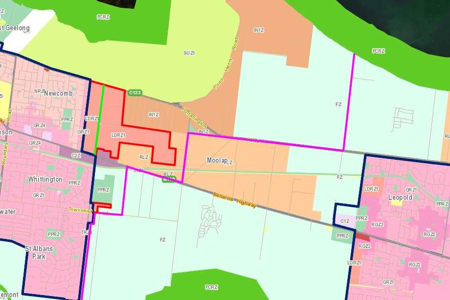
The inclusion of land into the settlement boundary often precedes requests to intensify land uses such as low density residential to conventional residential densities. In this case, the City is not looking at any intensification of this LDRZ precinct, but is recommending land on the east side of Coppards Road be included into the boundary to provide a robust, logical and long-term boundary to the eastern edge of urban Geelong. This will assist with the policy aspiration to provide a green break between urban Geelong and the Bellarine Peninsula. The inclusion of the whole LDRZ will not produce a more logical boundary than the use of Coppards Rd given it would use a combination of lot boundaries and 7 local roads (See red line boundary on figure 11 below).
If DTP do not support this position the options include amending the proposed boundary to include whole LDRZ precinct (red line, figure 11) or maintaining the existing boundary (blue line, figure 11).
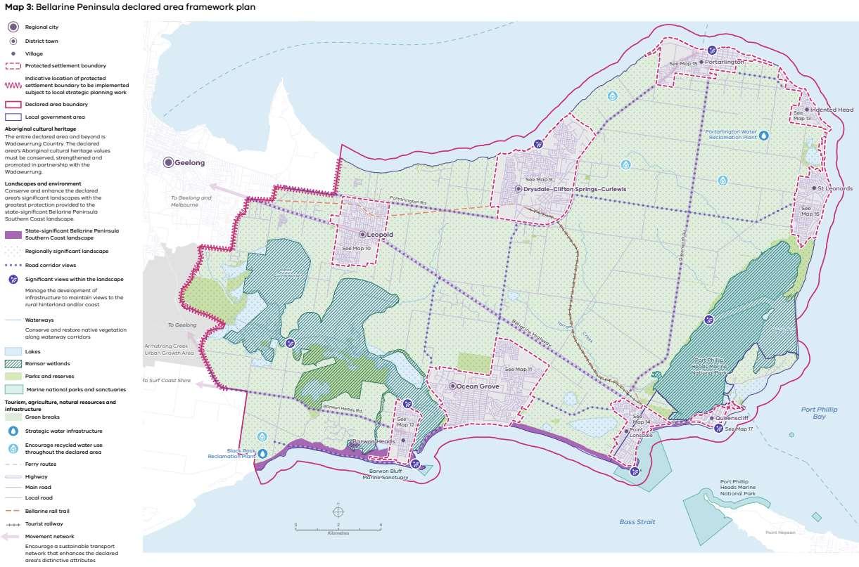
This area has implications for the Bellarine SPP as the framework plan nominates an indicative settlement boundary at the eastern edge of urban Geelong, see figures 11 & 12 below. The indicative boundary in the SPP extends all the way to Clifton Avenue, Leopold, goes west along the Portarlington Highway then south for a small section along Moolap Station Road, Earls Road then Coppards Road. The indicative boundary directly follows the declared area boundary rather than the existing settlement boundary. This is a different approach to the indicative boundary in the Surf Coast SPP which follows the existing settlement boundary rather than the declared area boundary. In this case the declared boundary is not considered an appropriate settlement boundary as it would include rural living and farm zoned land.
Existing settlement boundary
Proposed settlement boundary
Potential boundary if all LDRZ land is included
SPP indicative boundary (based on the declared area boundary)
Figure 11 –Boundary options in the Newcomb - Moolap area. Source: CoGG
Figure 12 –Famework Plan map showingindicative boundary (red zigzag line). Source: Bellarine SPP
The outcome of this review will inform the final position of the Protected Settlement Boundary in the Bellarine SPP which will be implemented by DTP.
The urban consolidation option put forward by submitters has been investigated further with Barwon Water and the City’s Engineers.
Barwon Water noted the area has access to sewerage and water and further development of this area is likely feasible without significant augmentation of existing assets.
Engineering Services advised there are significant stormwater servicing and flooding constraints in this low-lying area. The upgrades required to the network to deliver further development in this area are not likely feasible (costs and land area required for assets etc.). This area forms part of a wider catchment and any localised development could have broader flooding implications upstream. Flood prone areas in this part of Newcomb and Moolap are covered by the Special Building Overlay. For this reason, they have recommended against this area be nominated for ‘further investigation’ for future consolidation at this time.
Conclusion
The use of Coppards Road as the settlement boundary will provide a logical and defendable long term boundary bewtween the eastern edge of urban Geelong and the Bellarine.
Coppards Road is already used as the the boundary south of the Bellarine Highway. It is also the boundary between the suburbs of Newcomb and Moolap.
The extension of the settlement boundary to Coppards Road will not result in a recommendation to change the zone at this time.
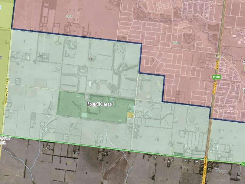
There is a recommendation to extend the boundary to include 55 & 75 Williams Road, Mount Duneed. Figure 13 below shows the existing boundary in blue and proposed boundary in red.
Figure 13 –Existing boundary (blue) and proposed boundary (red). Source: CoGG Summary of support for the recommendation:
This minor adjustment to the boundary (inclusion of ~16.2ha) is contiguous with existing urban land (assessment guiding principle 2).
The land can rely on existing services without creating additional need (assessment guiding principle 5).
The inclusion of this land will see the boundary in this location move from lot boundaries to Williams and Feehans Roads which is more robust and logical.
The visual analysis indicates urban development in this location will have a neutral impact on views of Mount Duneed (see addendum to Background Report).
Development of this site could support the completion of Feehans Road to the Williams Road intersection and connection to the proposed school. (assessment guiding principle 4).
Development of this site can support the upgrade of Williams Road to improve access to the Mount Duneed Primary School. (assessment guiding principle 4).
The development of this site provides opportunities to address local traffic management issues in this area, particularly at pick-up and drop-off times with the approved Catholic Primary school to be constructed and the existing Mount Duneed Primary school is close proximity (assessment guiding principle 4).
Submission
The submission made in support the inclusion of this site was supported by a planning report, infrastructure assessment, storm water assessment, landscape impact assessment and letter of support from Mount Duneed Primary School.
Discussion
The Background Report and Addendum provide detailed commentary on this site.
The inclusion of this land in the boundary will result in new urban development. The Neighbourhood Residential Zone is recommended to restrict development to two storeys and limit the impact on views of Mount Duneed. The application of a Development Plan Overlay/Design and Development Overlay will ensure the orderly planning of the area. Details of the proposed planning scheme changes can be found in section 5.0.
There is an option to pursue the rezoning of this land as part of the boundary review amendment. This will be further investigated with stakeholders as part of preparing the amendment documentation.
Conclusion
The inclusion of these lots produces a logical boundary using roads rather than lot boundaries.
There are road upgrade opportunities to support traffic management around existing and proposed schools.
The impact on the green break is neutral with the Mount Duneed ridgeline still the prominent landscape feature .
Existing canopy trees along Williams Road are to be retained to soften views.
4.4 ArmstrongCreekSouthWestandSouthCentralInvestigationAreas
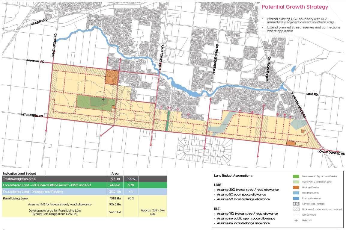
There is a recommendation to nominate land south of the existing Armstrong Creek Urban Growth Boundary to the municipal boundary (Mount Duneed and Lower Duneed Roads) as a rural living node.
Subject to further investigation and planning this would see the area change from the Farm Zone to the Rural Living Zone, see figure 13 below. No changes to the existing settlement boundary are recommended (except for the site noted above in section 4.3).
The Rural Living Zone would create approximately 238 to 596 lots based on lot sizes of 1– 2.5 hectares.
Given there are multiple land owners and fragmentation it is recommended the proposed rural living node be divided into an east and west precint from Torquay Road / Surf Coast Highway. A coordinated approach is required to deliver overall planning for the precincts and ensure the efficient delivery infrastructure and road, drainage and open space networks. Developer contributions will also need to be calculated.
Figure 14 –Proposed rural living zone shown in orange hatching. Source: Background Report Appendix 3 pg 6.
Summary of support for the recommendation:
The land is contiguous with existing urban zoned land (guiding principle 2)
Development of the area for Rural Living will not impact existing services (principle 5).
Some submitters noted farming in the area is becoming increasing problematic with urban encroachment.
The RLZ is part of the rural suite of zones and the proposed lot sizes will ensure this change will not ‘urbanise’ the area.
Housing and landscape policy objectives can be delivered via the Rural Living Zone and built form or landscape overlays.
The application of the Rural Living zone in this area will strengthen the existing settlement boundary by ruling out future urban expansion or consolidation.
Submissions
There were 27 submissions from Armstrong Creek South-West (11) and Armstrong Creek South Central (16) requesting inclusion in the boundary to facilitate some form of more intensive development (GRZ, LDRZ, RLZ or a combination). There are around 59 titles / 56 owners in the corridor. Three submissions in this area requested no change to the existing boundary to support the existing landscape and farming activities in the area. The submissions are summarised and responded to in chapters 6.1 and 6.2 in the Background Report.
A further submission from landowners in the ACSW area was provided in 2024 which included a survey of landholders in the area and their preferred land use outcome. The survey showed there was good support for the Rural Living Zone or a mix of zones from urban, Low Density and Rural
Living to transition the intensity of development from the existing urban area to the farmland in Surf Coast Shire (16/30). There were several unknown responses due to no response or landowners assuming because the land was in an investigation area it would be included in the boundary with the option to sell to a developer, these responses did not offer a preferred land use outcome (11/30). The remaining options included keep as farming (2/30) and make urban (1/30). The majority of landholders are supportive of a change to more intensive development of some kind.
Several submitters raised the issue of farm viability with the existing and proposed urban encroachment. They argued the current transition is inadequate to preserve the ability for landowners to carry out farming activities without issues relating to slashing, spraying, baiting, hay bailing, moving machinery, stray dogs, people trespassing (often to walk dogs), rubbish dumping and biosecurity concerns. Financial and land value issues were also raised.
Referral Response
DTP provided a response to the updated draft with boundary options and land use scenarios based on the further work (Appendix 3 in the Background Report ‘Mount Duneed Road Urban Design Options’) in November 2023. They identified five key issues for further consideration by Council:
Strategic justification – further strategic justification be provided in the context of the Bellarine Peninsula and Surf Coast Statements of Planning Policy (SPPs).
Scope – The potential scale and intensity of any new urban (in interface scenarios 1, 4 & 5, Background Report) development could impact the character of the Mount Duneed landscape and rural green break of the Surf Coast declared area.
Visual impact assessment – Confirm any new development in the Mount Duneed landscape does not protrude above the ridgeline and that visual impacts on the green break are minimised through detailed visual landscape assessments. (See discussion in section 3.2)
Urban-rural transition areas – Consideration should be given to the design and density of development in urban-rural transition areas of Armstrong Creek within the protected settlement boundary, consistent with section 5.9.7 of the Surf Coast Statement of Planning Policy.
Preferred option – The UGZ Interface Option 4 (excluding the land parcel at 10-40 Williams Road) creates a logical boundary and meets the scope of the review subject to undertaking further landscape assessment work to inform an urban-rural interface treatment.
The key issues are addressed in the discussion below.
Discussion
Strategic Justification / Policy
There is relevant state, regional and local policies that inform decision making on the long term/protected settlement boundary in relation to green break principles:
State Policy
11.03-5S Distinctive areas and landscapes
Strategies
Recognise the unique features and special characteristics of these areas and landscapes.
Implement the strategic directions of approved Localised Planning Statements and Statements of Planning Policy.
The Surf Coast SPP contains the following binding objective under section 5.3 Landscapes:
To conserve and enhance the declared area’s significant landscapes.
Regional Policy
11.01-1R -Settlement - Geelong G21
Strategies
Provide for settlement breaks between towns to maintain their unique identities.
Require a settlement boundary for all towns.
Protect critical agricultural land by directing growth to towns.
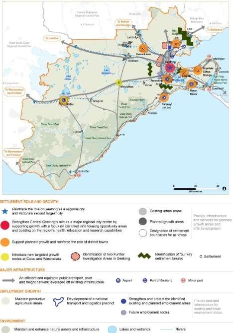
See figure 15 for the Regional Growth Plan.
Local Policy
Municipal Planning Statement (clause 02.03-1) objective:
Maintain the rural break between the ACUGA and Surf Coast Shire.
11.01-1L-01 Settlement - Greater Geelong
Strategies
Maintain the non-urban breaks between Geelong and Melbourne (Wyndham), Geelong and the Surf Coast, urban Geelong and the Bellarine Peninsula, and the townships on the Bellarine Peninsula.
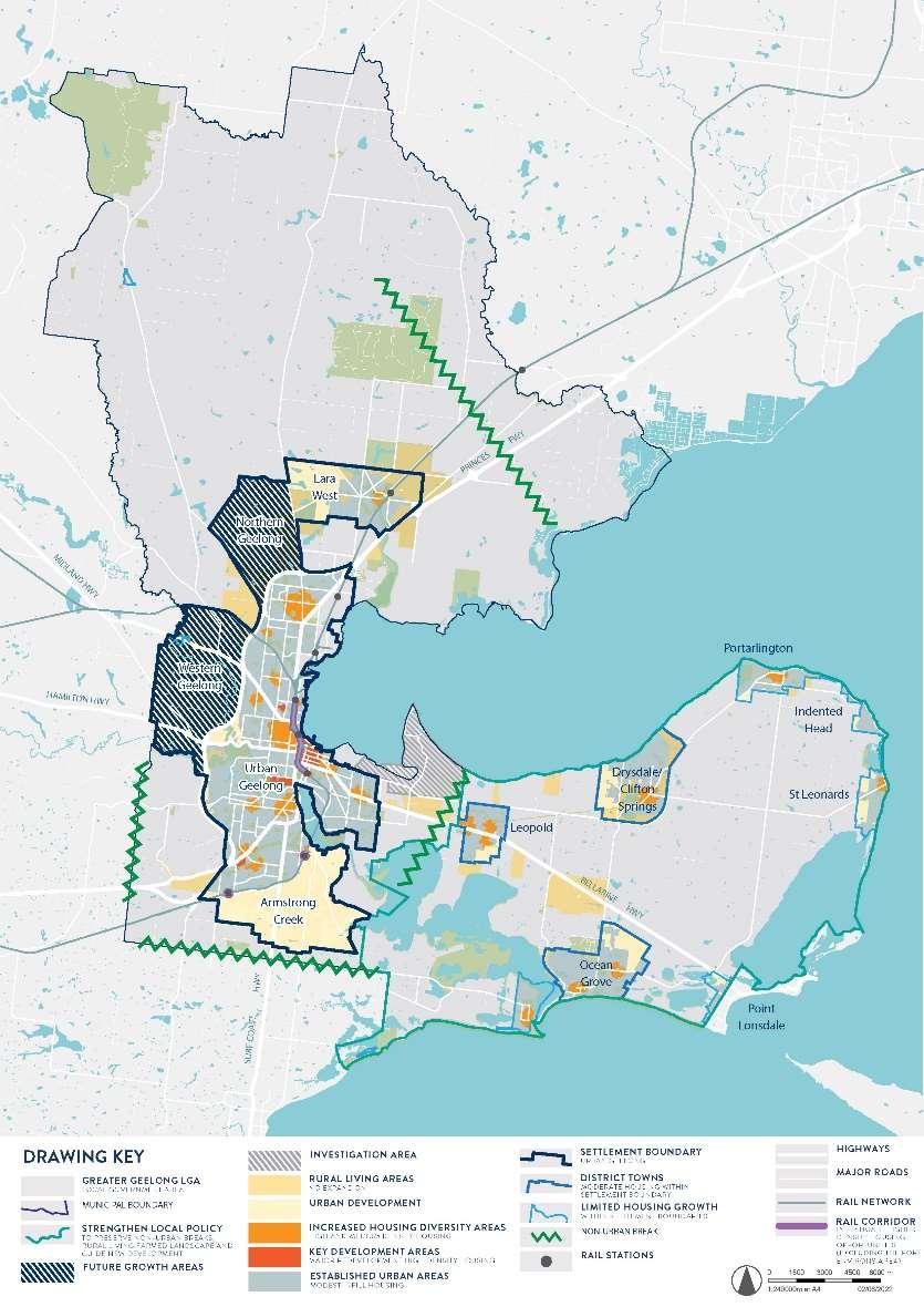
See figure 16 for the Greater Geelong Settlement and Housing Framework Plan.
Figure 15 –G21 Regional Growth Plan
16 –Greater Geelong Settlement and Housing Framework Plan Source: CoGG
Figure
Defining the Green Break
Armstrong Creek Growth Area to the Municipal Boundary
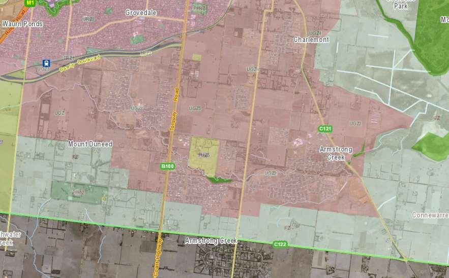
The rural break between the ACUGA and Surf Coast Shire municipal boundary varies in width from 425m near Horseshoe Bend Road to 1.65km near the Mount Duneed Recreation Reserve. The visual qualities of the break vary from open farmland with urban views (housing) beyond to farmed landscapes with tree rows and vegetation with little urban intrusion.
Figure 17 –Ruralbreak between ACUGA and the Surf Coast Shire. Source: CoGG
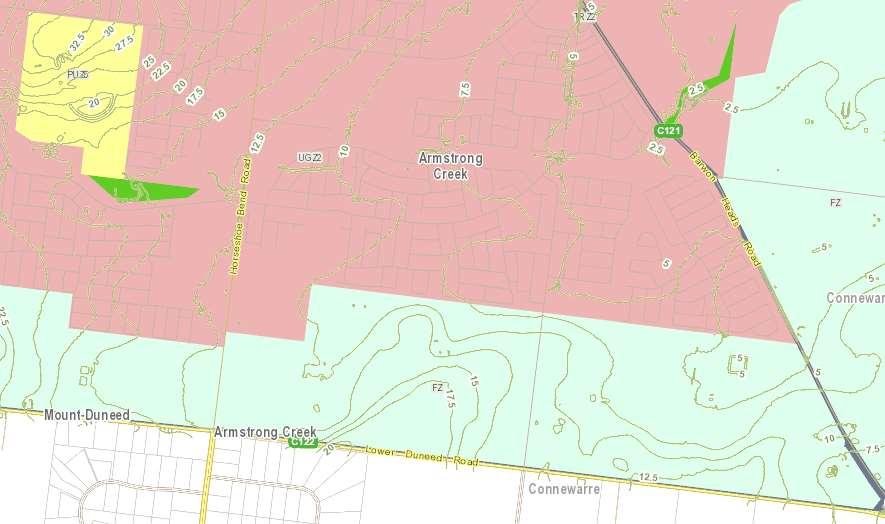
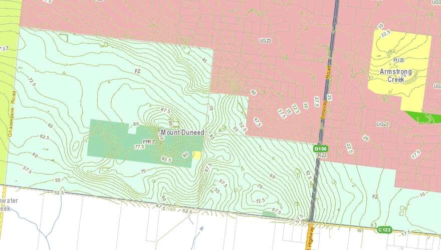
East of Horseshoe Bend Road is relatively flat (figure 18) with more undulation and gentle slope rising up towards Mount Duneed west of Surf Coast Highway (figure 19).
Figure 18 – Investigation area east of Surf Coast Highway showing contours. Source: CoGG
Figure 19 –Investigation area west of Surf Coast Highway showing contours aroundMt Duneed.
Source: CoGG
Green Break between the Urban Areas of Greater Geelong (Armstrong Creek) and Surf Coast (Torquay)
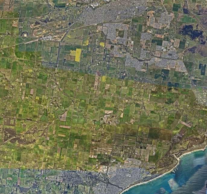
The green break between urban Geelong and urban Torquay is around 6km of farm zoned land (figure 20). The area is dominated by the Thompson Creek valley. The green break is experienced on the major transport corridors of Mount Duneed / Lower Duneed Roads, Surf Coast Highway and Anglesea Road.
The protection of this green break is supported in regional and local policy.
Figure 20 - 2022 aerial imageshowing the green break between urban Geelong and Torquay. Red hatched line indicates municipal boundary along Mt Duneed and Lower Duneed Roads. Orange line shows Low Density residential subdivisions in theSurf Coast Shire.
Source: Nearmap
Surf Coast SPP – Landscape Significance of the green break
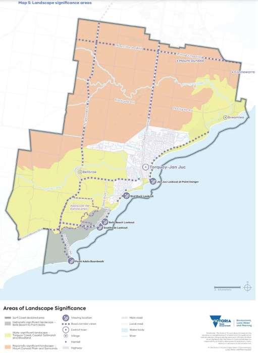
The SPP describes the Mount Duneed Volcanic Plain Landscape Character Area (figure 21 below) as:
‘a flat-to-gently undulating landscape that forms a rural, green break between Torquay–Jan Juc and Geelong. It includes the volcanic rise of Mount Duneed, Thompson Creek and a patchwork of paddocks and eucalyptus stands.’
The Surf Coast SPP provides the following statement for the regionally significant Mount Duneed Plain and Surrounds landscape:
‘The Mount Duneed Plain and Surrounds is a flat-to-gently-undulating landscape formed by volcanic flows of basalt. It includes the low, volcanic rise of Mount Duneed itself, with its unique geology and communities of grasslands. It also includes Thompson Creek, which winds its way from the coast at Breamlea, its upper and middle reaches cutting a pathway through the patchwork of paddocks that characterise this agricultural landscape.
Remnant eucalypts are a further feature of this landscape, found in riparian reserves, adjacent to road corridors and scattered throughout paddocks. They contrast with the mostly exotic, lineal shelterbelt planting. This is an open, expansive landscape of long, straight roads under big skies. It
is a very important green break between the built-up areas of Geelong and Torquay and the settlements of the Bellarine Peninsula.’
Figure 21 - Significant Landscape Areas under the Surf Coast SPP (Mount Duneed Volcanic Plain Landscape Character Area of regional significance hatched brown). Source: Surf Coast SPP
The DAL landscape assessment (Landscape Assessment Review Volumes 1-3, Claire Scott Planning, 2020) which informed the final SPP describes the area as:
‘Landscape Area 1.2 [Mount Duneed Volcanic Plain] within the Surf Coast Declared Area is characterised by flat to gently undulating topography. The highest point in the landscape is Mount Duneed itself, a low volcanic hill, with steeper upper and middle slopes, and gentle lower slopes, which support communities of grasslands. Mount Duneed Road is draped across the topography of this volcanic rise, emphasising further its elevation and affording expansive and long-range views across the open paddocks to the south.’
The relevant recommendations in this report included:
No additional residential development beyond the current zoned Urban Growth Boundary of Greater Geelong should occur.
To retain the rural outlook from inland main road corridors within the landscape, particularly Mount Duneed Road/Lower Duneed Road.
Built form should be characterised by the discreet placement of simple structures in the landscape, set back from main road corridors.
Remnant indigenous vegetation should be protected and increased in riparian road reserves, along waterway corridors, and throughout the rural paddocks, with consideration of the most appropriate EVCs to strengthen landscape character i.e. Plains Grassland, Grassy Woodland and Floodplain Riparian Woodland.
The Review Implementation Vol 2 pg 7 (Claire Scott, Surf Coast Landscape Assessment Review Volume 2) states:
‘The majority of the Mount Duneed Plain and Surrounds landscape is considered to be of low regional significance with areas of higher (moderate regional) significance coinciding with landscape features such as the Thompson Creek corridor, Mount Duneed itself, and the interface with the adjacent landscape of state significance.’
And recommended:
‘To appropriately manage the Mount Duneed Plain and Surrounds landscape of regional significance, of which the Thompson Valley Green Break forms an integral part, by confirming a protected, long -term settlement boundary for Greater Geelong in the location of the existing Armstrong Creek Urban Growth Area (ACUGA) boundary.’
The recommendations from the background reports to limit urban expansion were not included in the SPP. The SPP wording states:
5.9.7 Armstrong Creek urban growth area
‘The resolution of this settlement boundary is subject to the completion of local strategic planning work and public consultation, which will be led by the Greater Geelong City Council in collaboration with the Department of Environment, Land, Water and Planning, other relevant agencies and the Wadawurrung. This work should include consideration of the design and density of development in urban-rural transition areas within the protected settlement boundary that support the regionally significant landscape setting.’
Standing Advisory Committee for the Surf Coast SPP
In November 2020 a Standing Advisory Committee (SAC) was appointed by the Minister for Planning to consider submissions to the draft Surf Coast SPP.
The visual and landscape qualities of the break were considered in detail by the Surf Coast Standing Advisory Committee (SAC) during hearings in early 2021.
Submitters noted:
The City of Greater Geelong should not form part of the Surf Coast declared area.
Urban development of areas away from Mount Duneed could appropriately manage the urban/rural transition by facilitating development south of Armstrong Creek through providing larger allotments and landscape buffer strips along Mount Duneed/Lower Duneed Road.
The nature of the topography and roadside plantings means there is no impact on Mount Duneed if development were to extend to the lower slopes of Mount Duneed and provide a transition to lower densities.
The area is not economically viable or practical for farming purposes anymore.
The Committee found in its report made public in 2022:
The land holdings between Mount Duneed Road/Lower Duneed Road and the Armstrong Creek UGA should not be included in the draft SPP as a potential investigation area.
Greater Geelong should determine the location of the protected settlement boundary at an appropriate time in the future.
The Committee recommended:
Delete reference to the land south of the Armstrong Creek Urban Growth Area in the draft Statement of Planning Policy.
The wording in the final SPP is referenced above under the heading 5.9.7 Armstrong Creek urban growth area.
This boundary review project is the ‘local strategic planning work’ referenced in this section.
In its report the SAC noted the landscape work done to inform the SPP was not peer reviewed which they found ‘perplexing given the importance of the assessment’ (Distinctive Areas and Landscapes Standing Advisory Committee Surf Coast Report, 2021 pg 68). Of the landscape work they concluded that, ‘while the methodology may be appropriately high level for policy purposes, the classifications can be ambiguous and subjective when viewed at a finer scale.’
There are limitations to the broad scale landscape approach undertaken for the SPP when dealing with specific locations. This project has taken a more fine grain approach to the investigation areas to inform the final recommendation.
Rural Living and the green break
The key question is whether the proposed Rural Living Zone will maintain the rural break between the ACUGA and Surf Coast Shire urban Geelong and Torquay.
The Landscape Objective in the Surf Coast SPP is:
‘To conserve and enhance the declared area’s significant landscapes.’
The relevant strategies and a response to them is provided below:
o Strategy 3.3
Reserve green breaks between settlements for conservation, agriculture, nature-based tourism, nature-based recreation and natural resource proposals that prioritise the protection and enhancement of the significant landscape.
Response
A green break is defined under the SPP as:
‘Predominantly rural land located in between settlement boundaries that may comprise a variety of non-urban land uses (such as agriculture, hobby farms and agritourism businesses).’
The purpose of the Rural Living Zone is:
To provide for residential use in a rural environment.
To provide for agricultural land uses which do not adversely affect the amenity of surrounding land uses.
To protect and enhance the natural resources, biodiversity and landscape and heritage values of the area.
To encourage use and development of land based on comprehensive and sustainable land management practices and infrastructure provision.
Under this proposal the green break between urban Geelong and Torquay will be predominantly Farming Zoned land. The Rural Living Zone is a ‘rural’ zone and provides a rural environment with allowances for agriculture and the protection of landscape values consistent with strategy 3.3.
Lot sizes of 1-2.5 hectares (~2.5 – 6 acres) provides for adequate space around and between built structures, space for tree retention and new plantings, on-site storm water management and septic systems (if required, sewer may be available). Built form controls could be implemented to further manage development location, materials, scale, landscaping etc. For example, along Mount Duneed and Lower Duneed roads a buffer could be introduced to limit vehicle access, limit development directly adjacent to the roadside and preserve existing hedge row plantings to maintain ‘green’ views along the road corridor. Controls could also limit development above the ridgeline of Mount Duneed.
The landscape work prepared to support the development of the SPP notes:
‘Mount Duneed Road is draped across the topography of this volcanic rise, emphasising further its elevation and affording expansive and long-range views across the open paddocks to the south.’
When travelling along Mt Duneed Road it is the long-range views to the south over the Thompson Creek valley (Surf Coast Shire) from this elevated position that contributes most to the experience of the green break between urban Geelong and Torquay in this part of the corridor.
Lower Duneed Road does not have the same long-distance views as Mt Duneed Road given the less elevated topography in this location. The long-distance views to the south are rural in nature with views to the north a mix of rural and rural with the Armstrong Creek urban area visible beyond.
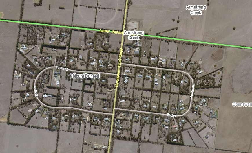
The images below show the Mount Duneed hamlet in Surf Coast Shire which is zoned Low Density Residential Zone (~1ha lots). The hamlet has a protected settlement boundary so further expansion
Figure 22 - Looking west along Mt DuneedRoad with Surfcoast Shire to the left andCity of Greater Geelongto the right. Source: Google street view
Figure 23 - View from Mt Duneed Rd looking south over the Thompson Creek Valley in Surf Coast Shire. Source: Google street view
Figure 24 - Looking west down Lower Duneed Rd with Surfcoast Shire tothe left and City of Greater Geelongto the right. Googlestreet view
Figure 25 - Lower Duneed Rd looking north across farmland to urban development in Armstrong Creek. Google street view
is not possible without amending the SPP. When travelling along Lower Duneed Road it is not immediately obvious there is a hamlet located on the south side of the road due to the lack of driveways, dominance of roadside vegetation, private gardens and minimal views to dwellings and/or outbuildings.
The images below (figures 27-30) are taken from in and around the hamlet with the map below (figure 26) indicating the location of the images.
Figure 26 - Mount Duneed Hamlet figures 25- 28 location. Source: CoGG
Figure 27 - Lower Duneed Road looking west (purple arrow) with Mount Duneed hamlet tothe left and Greater Geelongto the right. Source: Google street view
Figure 28 - Horseshoe Bend Road at the Lower Duneed Road intersection(red arrow) with the Mount Duneed Low Density ResidentialZone to the left and right. Source: Google street view
Figure 29 - View west down Kalkarra Drv at the Horseshoe Bend intersection (pink arrow) with LDRZ subdivision tothe left and right. Source: Google street view
Figure 30 - View east down KestrelCres at the Horseshoe Bend intersection (orange arrow) with LDRZ subdivision to the left and right. Source: Google street view
Figures 27-30 provide an example of views along road corridors in the LDRZ (minimum lot size 1ha in the Surf Coast Planning Scheme LDRZ schedule) which is similar to Rural Living Zone (Greater Geelong schedule) which provides lot sizes of a minimum 1 hectare.
In the SPP the Mount Duneed and Connewarre low-density residential areas are within the green break between the Armstrong Creek urban growth area in Geelong and Torquay–Jan Juc.
The Boundary Review Report (Mt Duneed Road Urban Design Analysis - Appendix 3) contains case studies from Woodend and Torquay which also looks at rural living and low-density development. It shows how design features and lots sizes influence the visual impact.
The Rural Living zone alongside design controls can preserve the attributes of the landscape and green break. The zone will help embed the protected settlement boundary by ruling out urban expansion or consolidation into the future.
o Strategy 3.5
Ensure any development that is allowed to be located in green breaks between settlements responds to the surrounding landscape character while maintaining the visual dominance of the natural landscape by:
being sited so that buildings are responsive to the landscape and use established vegetation or new vegetation buffers to screen development when viewed from the public realm
providing substantial setbacks from road corridors and publicly accessible land
using building forms, design detailing and materials and colours that immerse buildings within the landscape, so they are not visually dominant.
Response
The Rural Living Zone allows 2 hectare lots unless otherwise specified. Greater Geelong has a schedule allowing 1 hectare with the average area of lots in a subdivision being at least 1.5 hectares.
Any future rezoning and subdivision can include requirements to:
Minimise new access points onto Mount Duneed and Lower Duneed Roads to preserve roadside vegetation and the rural outlook when travelling along these roads.
Provide larger lots and building envelopes above ridgelines to maintain the dominance of the topography and vegetation against the sky.
Provide design guidelines to control built form outcomes (setbacks, materials, heights etc.)
Design subdivisions to preserve shelterbelt planting and significant vegetation.
The zone and development guidelines can meet strategy 3.5.
o Strategy 3.6
Ensure that high points and ridgelines remain free of development and associated infrastructure so that views to elevated areas of the landscape reveal the natural form of the topography and vegetation against the sky and are not visually dominated by built form or infrastructure.
Response
Managing lot sizes and providing built form controls can manage view lines and ensure the landscape including ridgelines remain the dominant feature of the area.
DTP Preferred Option
DTP have indicated a preference for the following:
‘The report includes a preliminary urban design study for addressing the interface between urban development in the Armstrong Creek urban growth area and the abutting rural area. The UGZ Interface Option 4 (excluding the land parcel at 10-40 Williams Road) in the Department’s view best meets the objectives for protecting the green break between urban Geelong and Torquay and minimising the visual impact of development. It creates a logical boundary and meets the scope of the review. I would encourage you to explore this option further, including undertaking further landscape assessment work to inform an urban-rural interface treatment.’
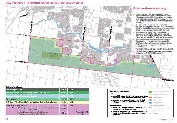
This option includes the addition of some urban land (see figure 31 below) with a ‘landscape corridor’ with trail along the UGZ interface.
This option is not preferred by Officers for a number of reasons namely:
Stormwater issues associated with additional urban development (discussed further on pg 46)
Cost recovery opportunities for the potential number of lots compared with the cost to upgrade infrastructure for conventional residential development as part of a DCP or similar.
The funding, securing, delivery and ongoing maintenance for the landscape corridor with trail across the investigation area. The land and embellishment would go beyond an open space development contribution and require significant Council funding. There is a significant existing linear open space with trail along Armstrong Creek around one kilometre away.
Figure 31 –Option 4 in the Mt Duneed Road Urban Design Analysis Appendix 3, BackgroundReport.
Other Considerations
Planning
Practice
Note 37 Rural Residential Development
Planning Practice Note 37 Rural Residential Development (June 2015) states:
‘Rural residential development refers to land in a rural setting, used and developed for dwellings that are not primarily associated with agriculture. Some agriculture may take place on the land however it will be ancillary to the use for a dwelling. It is likely to be carried on for ‘lifestyle’ reasons and is unlikely to provide a significant source of household income. Rural residential land is typically also used for non-agricultural home occupations or for large gardens. These lots are larger than typical residential lots, but are usually too small for agricultural use.
Because of its primarily residential function, rural residential development requires access to most of the normal services and infrastructure provided in urban settlements. Typically it also generates urban residential amenity expectations.’
The practice note outlines broad questions to be answered in sequence when considering the application of this zone:
Strategy: Does rural residential development align with the overall strategic planning of the municipality?
Greater Geelong ‘s settlement policy (02.03-1) includes the following commentary:
‘Rural living areas offer an important lifestyle choice in the housing market. However, they can be inefficient to service and are generally contrary to the objective of maintaining a farmed rural landscape and supporting agriculture in rural areas. Farming and rural landscapes form non-urban
breaks and are a critical element to the settlement strategy, tourism function and lifestyle of the region.’
And strategic direction:
Limit rural-living developments to existing zoned land in Lara, Drysdale/ Clifton Springs, Wallington, Waurn Ponds, Lovely Banks Batesford, Fyansford, Leopold, Newcomb, Moolap, Curlewis, Portarlington and Ocean Grove.
Response
Commentary is provided in the Background Report around why the Rural Living zone could deliver the policy objectives for the area. The reasons are summarised as:
Agricultural practices in the area are compromised by the proximity of urban development and mix of lot sizes.
Rural living lots between 1-2 hectares can preserve the rural landscape.
Servicing can be accomodated given the Armstrong Creek growth area directly abuts to the north.
Rural Living development has the potential improve access arrangements to the Mount Duneed Primary school via upgrades to Williams Road.
The Rural Living zone will provide a diversity of housing choice in this area of Geelong.
The Rural Living zone will stregthen the protected boundary/long-term boundary for Armstrong Creek by ruling out urbanisation in the future through fragmentation, zone and development controls.
The Rural Living zone could provide an attractive transition from rural to urban areas.
The Surf Coast SPP notes the process to nominate a protected settlement boundary:
‘should include consideration of the design and density of development in urban-rural transition areas within the protected settlement boundary that support the regionally significant landscape setting.’
The SPP defines the urban-rural transition area as:
‘an area that provides a soft edge between urban development within a settlement boundary and the rural land beyond, to minimise the visibility of the development and better manage the settlement’s environmental and landscape impacts.’
There is no guidance on this for the Armstrong Creek urban growth area however text in the Torquay–Jan Juc coastal character statement provides the following description:
‘At the urban-rural interface, generous transition areas within the protected settlement boundary provide a transition to the surrounding rural landscape, and the visibility of the settlement from green breaks is minimised. These character aspects are achieved with reduced dwelling densities, reduced building heights, smaller building footprints, larger lot sizes and substantial landscaping or generously vegetated buffers using fire-resistant indigenous species. Materials and finishes that temper visibility (such as darker materials and materials that weather naturally) are used. All development responds to bushfire risk.’
In the case of the Armstrong Creek growth area this type of ‘urban-rural transition’ cannot be achieved given the area within the boundary has already been planned and is partially constructed.
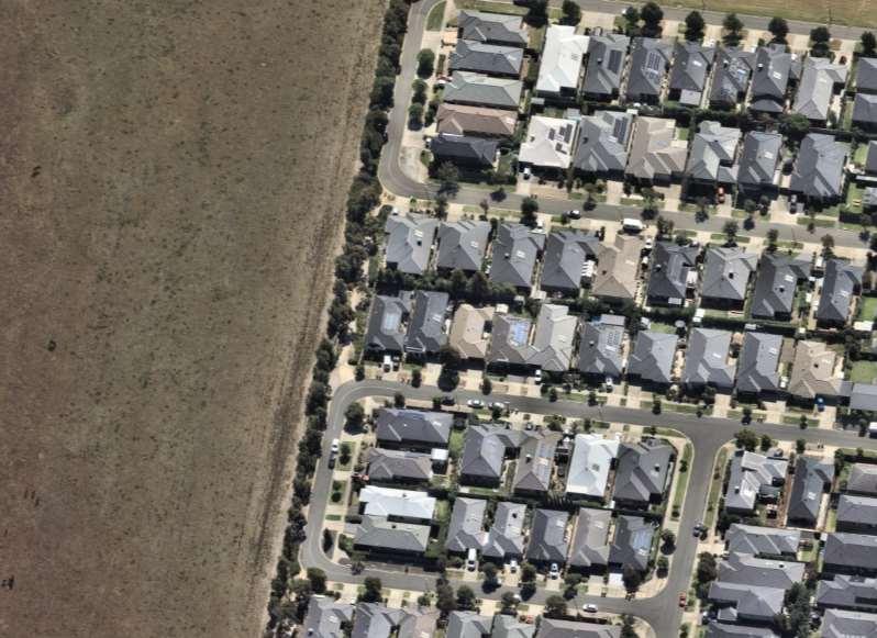
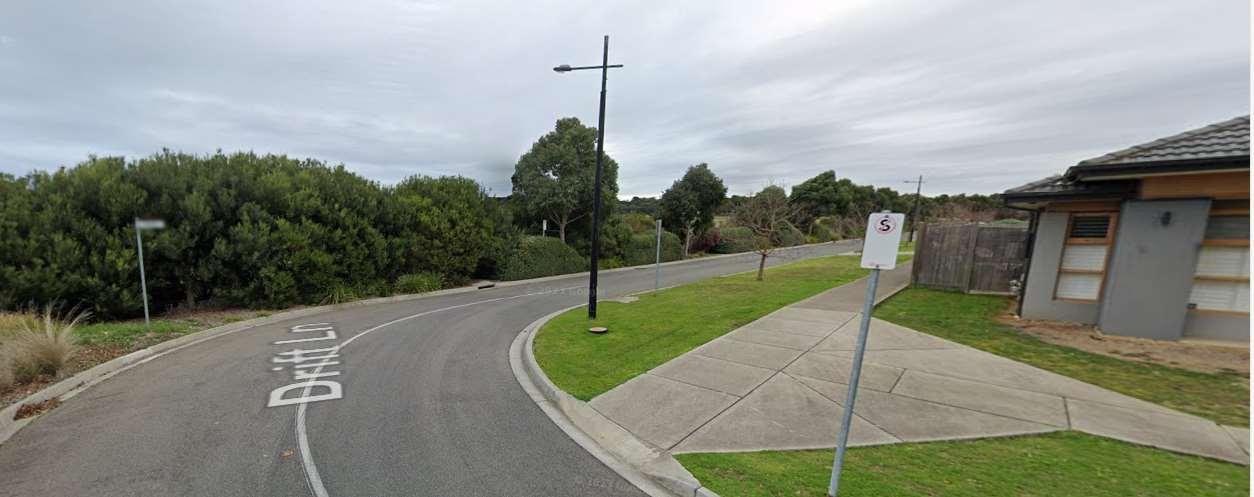
The existing urban-rural transition or interface consists of a combination narrow vegetation strip along the roadside alternating with narrow-shared path with landscaping. See figures 32 & 33 below.
Figure 32 –Aerial image of boundary treatment between the ACGA and farming zone comprising of a local road or walkway with vegetation strip. Source: CoGG
33 –Image of boundary treatment betweenthe ACGA and farming zone showing the vegetation strip. Source: Google images.
It is not considered this wording explicity excludes the Rural Living zone (which is a rural zone) outside the bounday where the existing urban-rural transition within the existing boundary remains unchanged.
Arguably, the narrow landscape strip and road frontage would not meet the transition requirements if they were proposed today with the SPP in place, however, they are already planned and partially constructed.
The application of the Rural Living zone to the corridor could achieve the design outcomes being sought in the SPP without having to expand the settlement boundary. The advantage of the Rural Living zone remaining outside the settlement boundary includes consistency with rural zones being applied outside settlement boundaries, there will be no future pressure to pursue urban
Figure
consolidation within the boundary and limiting the option to expand the boundary for urban purposes in this location into the future due to fragmentation and design controls.
Where urban views of the Armstrong Creek growth area are more obvious when travelling along Lower Duneed Road the rural living zone could ‘temper’ these views through the retention of roadside vegetation (along Mount Duneed and Lower Duneed Roads), subdivision layouts that accommodate existing shelterbelts and significant vegetation, additional boundary plantings and the establishment of private gardens that will also increase screening.
The Mount Duneed hamlet in the Surf Coast Shire is an example of a Low-Density Residential estate that remains largely unseen when driving along Lower Duneed Road (previously discussed in the green break section above).
The local policy can be amended to include this rural living precinct as a node.
Housing need: How much rural residential development is required to provide appropriate housing diversity and choice to meet housing needs?
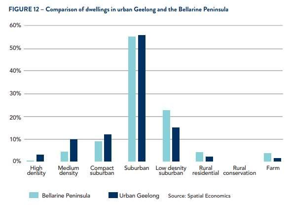
The Settlement Strategy notes there is limited remaining capacity for rural living development, with demand being increasingly diverted to neighbouring municipalities such as Golden Plains Shire. The graph below also shows Rural Living makes up a relatively small proportion of housing in Greater Geelong. The addition of some RLZ land in this location will provide a housing option that is not currently provided in this part of Greater Geelong.
Figure 34 –Settlement Strategy figure showing dwelling types in Greater Geelong. Source: CoGG Settlement Strategy
The provision of Rural Living zoned land in this area will provide a housing and lifestyle choice not currently offered in the Armstrong Creek area. There is housing demand for this lifestyle choice and Greater Geelong has not been supplying this housing option since at least 2007, post the Rural Land Use Strategy. Greater Geelong has also been losing areas of Low Density and Rural Living areas as part of urban consolidation efforts in Lara, Leopold, Drysdale and Ocean Grove which this precinct could replenish.
Location: Where should new rural residential development take place?
The location south of the Armstrong Creek Urban Growth area means the area can connect into and be serviced by infrastructure such as water and sewer, education, retail/activity centres, open space etc.
The Rural Living zone could produce between 238 – 596 lots depending on the ultimate lot size mix. Infrastructure assessments by the social planning and open space teams have confirmed the existing and planned infrastructure in the Armstrong Creek Growth Area could cater for this additional population.
The civil infrastructure team raised concerns about any additional urban development that would result in stormwater being diverted into the Armstrong Creek Growth Area drainage network. The network was designed to meet the needs of the growth area as planned and does not have additional capacity especially during high rainfall events.
The civil infrastructure and environmental planning teams also raised concerns about the Sparrovale-Nubitj yoorree Wetlands which takes stormwater from Armstrong Creek Growth Area prior to it making its way into the Lake Connewarre system. The balance of stormwater (fresh water) entering the system has an impact on salinity levels in the wetlands. Any increase in urban areas and therefore stormwater could change the ecology of the area and impact the Ramsar listed wetlands.
Due to the low site coverage and high permeability of Rural Living lots, stormwater can largely be managed on-site and the stormwater issues can be mitigated. The civil infrastructure team were not supportive of significant additional urban areas but were open to the Rural Living zone.
The planning delivery team noted the cost recovery based on the potential number of lots compared with the cost to upgrade infrastructure for conventional residential development was significantly reduced with Rural Living Zone development. Any Rural Living development would need to make an infrastructure contribution to support road upgrades and contribute to community infrastructure.
Subdivision and design: Is the new rural residential development subdivided and designed in an attractive setting offering high amenity and efficient infrastructure?
The location and attributes of the area means it will be able to offer a very attractive and well serviced lifestyle option. Any future subdivision should consider:
- any treatments required along Mt Duneed and Lower Duneed Roads to preserve roadside vegetation and rural views such as a linear shared path reserve.
- No or limited vehicle access from Mt Duneed and Lower Duneed Road to preserve roadside vegetation and limit ‘urban’ intrusions into view lines.
- Built form guidelines to ensure development does not protrude above ridgelines and complements the landscape.
- Retention of hedge row/wind break plantings and significant scattered trees.
- Connections back into the existing or planned estates to maximise connections and efficient infrastructure provision and
- Consideration of development contributions to contribute to community infrastructure.
Summary
The area forms part of a regionally significant landscape and green break between Greater Geelong and Surf Coast in the Surf Coast SPP, Surf Coast and Greater Geelong Planning Scheme and G21 Regional Growth Plan.
The green break is experienced along the key transport corridors of Mount Duneed / Lower Duneed Roads, Surf Coast Highway and Anglesea Road as well as other minor roads.
The rural living zone located outside the settlement boundary will strengthen the settlement boundary and preserve the green break in the long-term.
The proposed Rural Living node will reinforce the settlement boundary by ruling out future urban consolidation or urban expansion.
The rural living zone is consistent with green break objectives to provide a rural environment and protect landscape values.
Landscape values can be managed using different lot sizes, subdivision design can limit access to key transport/view corridors and preserve existing vegetation and built form controls such as building envelopes and design control overlays.
The existing rural-urban transition remains unchanged and within the settlement boundary.
The proposed Rural Living node can take advantage of the proximity to the Armstrong Creek Growth Area for services, facilities and infrastructrue.
The Rural Living node provides a housing choice not currently available in this part of Greater Geelong.
Bellarine Peninsula Statement of Planning Policy – Protected Settlement Boundary
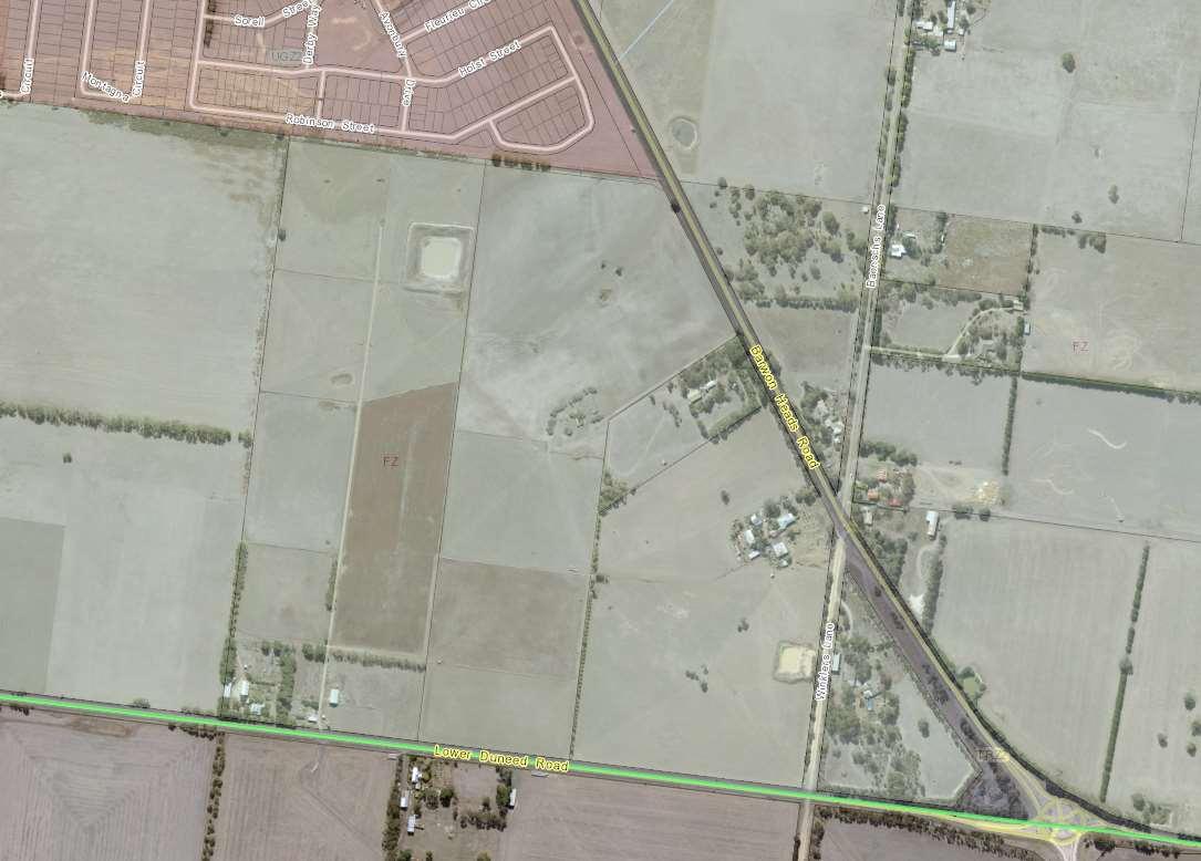
The Armstrong Creek investigation areas also takes in part of the future Bellarine Protected Settlement boundary, refer to Figure 12 - Bellarine Peninsula Framework Plan. The extent of the settlement boundary is in line with the Bellarine Declared area existing boundary. There is an opportunity to deliver the wider road reserve currently missing between the Urban Growth zone and Winklers Lane (see figure 35 below) with the introduction of the Rural Living zone.
Figure 35 –Missing road widening reservationbetween the UGZ and Winklers Lane (red line). Source: CoGG.
5.0 Proposed Planning Scheme Changes
The following changes are recommended to the ordinance and maps in the Greater Geelong Planning Scheme. These are draft only and will be subject to change as part of the amendment drafting and further consultation with stakeholders:
1. Update map in clause 02.04-1 Municipal Framework Plan and 02.04-3 Housing and Settlement Framework Plan to reflect the three inclusions into the settlement boundary and proposed Rural Living Zone node (generally in accordance with map 1 – executive summary) and to update the key on map 02.04-3 to change the ‘settlement boundary’ designation to ‘long term settlement boundary’.
2. Update 02.03-1 Settlement to include Mount Duneed-Armstrong Creek:
LimitrurallivingdevelopmentstoexistingzonedlandinLara,Drysdale/CliftonSprings, Wallington,WaurnPonds,LovelyBanks,Batesford,Fyansford,Leopold,Newcomb,Moolap, Curlewis,PortarlingtonandOceanGroveandMountDuneed-ArmstrongCreeknode.
3. Update 11.03-L Regional and local places to include a new policy for the Mount Duneed –Armstrong Creek Rural Living Node/Precinct to include objectives and strategies and include the Background Report as a policy document.
02.03-1 Draft New Policy (indicative only - final policy confirmed through the amendment process)
Mount Duneed – Armstrong Creek Rural Living Node
Policy application
ThispolicyappliestolandidentifiedintheMountDuneed–ArmstrongCreekRuralLivingNode Map.
Objective
TofacilitatetheorderlydevelopmentofaRuralLivingprecinctthatrespectstheidentifiedlandscape andgreenbreakvalues.
Strategies (Comment: DPO/DDO may also be utilised to facilitate these outcomes)
Facilitateplanningfortwokeyinvestigationareaswithintheprecinct,eastandwestofTorquayRoad.
FacilitateavarietyoflotsizesthatpreservekeyviewssuchastheMountDuneedridgelineandkey roadcorridorviews.
MinimisethenumberofnewroadsthatintersectwithLowerDuneedandMountDuneedroads.
Encouragetheretentionofroadsidevegetation.
Encouragetheretentionofexistingvegetationsuchashedgerowsandsignificanttreesthrough responsivesubdivisiondesign.
EncourageconnectionsintotheArmstrongCreekurbangrowtharea.
EncourageimprovedconnectionstotheMountDuneedPrimarySchoolonWilliamsRoadand proposedschoolonFeehansRoad.
SupportbuiltformdesigncontrolsthatseektoreducethevisualimpactofdevelopmentfromMount DuneedandLowerDuneedRoadssuchaspostandwirefencingandnobuildingzonesadjacenttothe roadsides.
LimitdevelopmentabovetheridgelineofMountDuneedtopreservethedominanceofMount Duneedinthelandscape.
Policy Document
UrbanGeelongLong-TermBoundaryReviewBackgroundReport,July2023.
Draft New Overlay Controls
Development Plan/Design and Development Overlay (or similar)
Any rezoning proposal will need to consider the following key matters:
Urban Design Masterplan
Integrated transport and access plan
Integrated Water Management Plan
Open Space and Landscape Masterplan
Biodiversity Assessment
Environmental Assessment
Cultural Assessment
Shared Infrastructure Funding Plan (or Development Contributions Plan)
Servicing Plan
Staging Plan
4. Potential to rezone land at 145-153 Harriots Road to a residential zone as part of the boundary review amendment.
Officers will seek to progress rezoning alongside the boundary review amendment in consultation with the landowners/proponents.
The rezoning should investigate servicing and connection/integration opportunities with the estate being developed west of the site.
While the proposal will need to be formally referred to the CCMA for the rezoning/subdivision application the initial advice based on the submission indicates the following requirements will be likely:
1. Before the certification of the plan of subdivision under the Subdivision Act 1988, a restriction must be placed on the plan of subdivision identifying land outside the 1% AEP floodplain on each lot which states that:
a. no building shall be constructed outside the building envelopes shown hatched on this plan.
b. All fencing within the 1% AEP floodplain to be post and wire to allow the free passage of flood flows through the fence, thereby preventing floodwaters backing up and affecting neighbouring properties and dwellings.
Definitions:
- ‘AHD’ – Australian Height Datum
- ‘Building’– as per the Planning and Environment Act 1987 definition, excluding a fence.
- Variations: Variation of these requirements will require approval from the responsible authority.
c. No building is to be constructed on any of the lots on this plan with a finished floor level less than the level stated in the table below.
5. Potential to rezone 55 & 75 Williams Road, Mount Duneed to the Neighbourhood Residential Zone with DPO/DDO.
Officers will seek to progress rezoning alongside the boundary review amendment in consultation with the landowners/proponents. Some of the key considerations will be:
55 & 75 WILLIAMS ROAD DESIGN AND DEVELOPMENT / DEVELOPMENT PLAN OVERLAY
Draft Overlay (indicative only - final overlay confirmed through the amendment process)
Design objectives
Tointegratethesubdivisionintotheexistingandplannedurbandevelopmenttothenorthandeastof thesite.
TocreateasafeandintegratedmovementnetworkthatincludessealedaccesstotheMountDuneed PrimarySchoolonWilliamsRoad,thenewprimaryschoolonFeehansRoadandintersectionupgrade ofWilliamsandFeehansRoads.
ToretainandenhancethevegetationalongWilliamsRoadtoensurethe‘greenbackdrop’towards MtDuneedandtheridgelinetothesoutheastisretained.
Toensurebestpracticestormwatermanagementandwaterqualitytreatmenttopreventanyadverse impactondownstreamareas.
Subdivision considerations
SubdivisionPlan
Transportandaccessplanincludinganintegratedandcontinuousnetworkofsafeand convenientfootpaths
StormWaterManagementPlan
OpenSpaceandLandscapeMasterplanincludinganopenspacecontribution(incashorland oracombinationofboth)toaminimumof10percentofthedevelopableresidentialland.
EnvironmentalandCulturalassessments
Infrastructure Contribution/DevelopmentContributionsPlan
Depending on the timing and complexity of the rezoning it may be a separate proponent led amendment will be required in the future separate to boundary review amendment.
AppendixA–ReportRecommendations&OfficeResponse
The following table provides the Background Report recommendations and Officer response.
Report Recommendation
1.0-ArmstrongCreekSouthWest
1.1 MtDuneedRoad(westofWilliamsRoad)
This area should not be included within the Geelong Settlement Boundary. However, further consideration should be given to rezoning land within this area to the Rural Living Zone. Any rezoning of this land be accompanied by a requirement to prepare a development plan, infrastructure plan and infrastructure funding agreements.
1.2MtDuneedRoad(eastofWilliamsRoad)
This area should not be included within the Geelong Settlement Boundary. However, further consideration should be given to rezoning land within this area to the Rural Living Zone. Any rezoning of this land be accompanied by a requirement to prepare a development plan, infrastructure plan and infrastructure funding agreements.
1.3WhitesRoad
It is recommended that the land south of Whites Road (between Ghazeepore Road and 10-40 Williams Road) remain outside of the settlement boundary.
1.4Central(invicinityofWhitesandWilliamsRoad)
Site1-PurdiesPaddock(55&75WilliamsRoad,MtDuneed):
Purdies Paddock be included within the Geelong Settlement Boundary, subject to confirmation that developing this land for housing will have an acceptablevisual impact on views to Mt Duneed when viewed from the east, along Lower Duneed Road.
A structure plan, infrastructure plan and infrastructure funding agreement be prepared for the future residential development of the land.
Following the preparation of the abovementioned plans and agreement, a planning scheme amendment should be initiated to rezone ofthe land to give statutory effect to the structure plans infrastructure funding agreements.
Site2-10-40WilliamsRoad,MtDuneed:
The northern lot of 10-40 Williams Road be considered for inclusion within the Geelong Settlement Boundary, and the southern part of this site be considered for rezoning to the Rural Living Zone, subject to confirming that development on this land for housing will have an acceptablevisual impact on views to Mt Duneed when viewed from the north and north east (i.e. locations suchas the Armstrong Creek Waterway, town centre and Waurn Ponds Station).
A structure plan, infrastructure plan and infrastructure funding agreement be prepared for future residential development on the northern part oftheland. This plan (together with any development plan for the southern part of the site that is identified for rural living purposes) should make provision for the creation of a wide linear open space corridor in the vicinity of the 65AHD contour. This link should connect along the western site boundary to Whites Road, to delineate thelongterm edge of urban Geelong in this location.
Officer Response
Supported. This land will remain outside the boundary and the RuralLiving Zone is supported.
Supported. This land will remain outside the boundary and the RuralLiving Zone is supported.
Supported. This land will remain outside the boundary.
Additional Recommendation: Officers also support the Rural Living Zone for this area.
Officers support the inclusion of 55 & 75 Williams Road. There is the potential to rezone land as part of this boundary review amendment subject to further investigation with stakeholders.
Officers support the exclusion 10-40 Williams Road due to landscape and drainage concerns.
The Addendum report provides additional information of the landscape and view impacts.
Officers support the Rural Living Zone for this area.
Following the preparation of the abovementioned plans and agreement, a planning scheme amendment should be initiated to rezone the land to give statutory effect to the structure plan’s infrastructure funding agreements.
Ifthere is any doubt about being able to successfully realise the above outcomes then Whites and Williams Road should remain as the longterm settlement boundary in this location.
2.0-ArmstrongCreekSouthCentral
2.1LandnorthofLowerDuneedRoad
The current location and form of the Armstrong Creek Central settlement boundary is not particularly logical or enduring, and it requires modification.
Alternate settlement boundary concept could comprise:
•Larger (1.5-3ha) rural living lots on the land north of Lower Duneed Road and on thecorners of the Surf Coast Highway and Barwon Heads Road.
• Smaller (0.2-0.4ha) rural living lots between the abovementioned larger lots and the linear open space corridor along the alignment of the settlement boundary, to provide a transition in density towards the settlement boundary.
2.2LandeastofBarwonHeadsRoad
It is recommended that there be no change to the settlement boundary in this location.
3.0-Sparrovale
3.1Northernarea
It is recommended that 145 Harriots Road be included within the settlement boundary (subject to confirmation of the Flood Overlay and LSIO via Amendment C133).
3.2Southernarea
It is recommended that there be no change to the settlement boundary in this location.
4.0-Moolap
4.1Northernarea
It is recommended the settlement boundary move to Coppards Road but land within it should remain within the existing Low Density Residential Zone unless any proposal to rezone the land can demonstrate with a high degree of confidence that the necessary infrastructure and development issues can be delivered in a cost-effective and orderly manner.
4.2Southernarea
It is recommended that there be no change to the settlement boundary in this location.
5.0-WaurnPondsNorth
It is recommended that there be no change to the settlement boundary in this location.
6.0-WaurnPondSouth
It is recommended that there be no change to the settlement boundary in this location.
7.0LaraNorth
It is recommended that there be no change to the settlement boundary in this location.
8.0LaraSouth
Changed recommendation.
Officers do not support moving the settlement boundary inthis location.
Officers support the Rural Living Zone for this area.
Supported.
Supported. The flood overlay has been confirmed. There is potential to support rezoning as part of the amendment in consultation with stakeholders.
Supported.
Supported. Moving the boundary to Coppards Road is supported and maintaining the existing LDRZ is supported. The City’s engineers have flagged stormwater issues that prevent further consolidation at this time.
Supported.
Supported.
Supported.
Supported.
It is recommended that there be no change to the settlement boundary in this location.
9.0Avalon
It is recommended that there be no change to the settlement boundary in this location.
Supported.
Supported.


