DMARKS

LAN
THE JOURNAL OF UNDERGRADUATE GEOGRAPHY volume vi // 2020

THE JOURNAL OF UNDERGRADUATE GEOGRAPHY volume vi // 2020
The cover illustration was made by Monica Pramanick (oh no moe! Illustration). Inspired by the themes in this issue, including climate, migration, and resistance, it aims to explore the complex relationship between land and identity.
Online version available at landmarksjournal.geog.utoronto.ca
Contact us at landmarks.journal@gmail.com
Khalood Kibria
MANAGING EDITORConnie Yang
Emmy Borlé
Willow Cabral
Alison Feise
Lisa Holliday
Kristal Sinaj
Karina Velazquez-Lara
A Rejection of Canada’s “Best Practice”: A Closer Look at Migrant Agricultural Labour Madeleine Reyno
Infrastructure and Climate Change in a Post-Colonial City: The Case of Georgetown Hanna Given
LRT Erasing Ethno-Cultural Enclaves: Examining the Relationship between Public Transit, Housing, and Gentrification Malek B. Abdel-Shehid
The “Bogus Refugee”: The Impact of “Nomadacy” for Romani People Claiming Refugee Status Sydney N. Wilson
Bodies and Futurity in the Uranium Landscape of Oljato Mesa, Navajo Nation Aisha Assan-Lebbe
Targeted Climate Destruction in New Orleans: The Racialized Socio-Spatial Impacts of Hurricane Katrina Brittany Livingston
Refugees’ Identity in a State of Exception: Exploring Refugees’ Nationality in Dadaab Keenan Krause
Tiny Houses: Colonial Nostalgia and Indigenous Resistance Lee Silden
48 55
Landmarks: The Journal of Undergraduate Geography
The Editorial Board is proud to present the sixth volume of Landmarks: The Journal of Undergraduate Geography. This year’s volume is exceptional in that it was completed during a global pandemic. The spread of COVID-19 has resulted in lockdowns, isolation, loss, sickness, grief, and a rapidly evolving economic crisis. The pandemic has also exposed the deep structural inequalities that shape human life today. While some have had the privilege of staying in their homes or leaving crowded cities to escape to less populated regions, others have been forced to continue their jobs outside the safety of their homes because they are essential workers or because they face evictions if they fail to pay rent. Numerous contradictions such as these show us that communities are undoubtedly experiencing this pandemic in radically different ways, especially along the lines of race, class, and geography.
Although this issue was conceptualized prior to the global spread of COVID-19, it explores themes that are especially relevant in the present moment. The contributors to this issue help us think about how crises of all varieties impact communities differently, why such inequalities exist and proliferate, and how people continue to survive and resist amidst such conditions. In the following pages, you will find outstanding pieces from the department’s undergraduate cohort that open up key contemporary issues. Authors explore the exploitation of migrant labour in Canada’s agricultural sector, climate injustice and destruction of infrastructure in Guyana’s Georgetown, the gentrification of Toronto’s Little Jamaica, the systemic discrimination against Roma refugees, uranium mining in the lands of the Navajo Nation, environmental racism during and after Hurricane Katrina in New Orleans, life in a perpetual state of exception in Kenya’s Dadaab refugee camp, as well as the settler colonial logics of the white North American “tiny house” movement. The articles simultaneously discuss the ways in which communities across the world have developed and protected their own relationships with various geographies and continue to struggle for their dignity, sovereignty, and liberation.
The contributors leave us with thoughtful analyses that push us to think more deeply and critically about the many crises that existed prior to COVID-19, crises that continue to grow in varying capacities during this pandemic, and crises that will likely await us afterwards. I invite you to read this issue and ask yourself: what might a new “normal” look like? What can be learned from existing crises and what might we do differently this time? How can we reimagine our relationships with each other and with the spaces in which we live, work, and find pleasure?
The Editorial Board is grateful to the Department of Geography and Planning for their ongoing support of the journal. We want to thank the many students who submitted their papers for consideration; it was a pleasure to read your work. We are incredibly grateful to all the contributors for their hard work and the care they put into completing this issue during a remarkably difficult time. We want to thank Monica Pramanick for the beautiful cover art. I want to especially extend a heartfelt gratitude to the entire team of editors for their labour, dedication, and patience over the course of many months, and to Connie Yang for her leadership. We hope that you are in good health and are able to enjoy the sixth volume of Landmarks.
Sincerely, Khalood Kibria, Editor-in-Chief Landmarks: The Journal of Undergraduate Geography
Madeleine Reyno Canada’s agricultural sector relies heavily on the labour of migrant farm workers. As a result, the Canadian state has created programs that monitor and regulate this labour, some of which have been internationally praised as “best practice” models. This paper examines one of the state-sanctioned programs that creates the conditions for migrant labour in Ontario’s agricultural sector, the Seasonal Agricultural Workers Program (SAWP). Though the program is praised for its contributions to Canadian agriculture and economies, to what extent does it create appropriate conditions for the equitable treatment and insurance of safety and security for these workers, both historically and in the present? Through a critical engagement with documentary sources, media statements, and film, this paper examines the history of the program, its ties to global capitalism, employer-worker relations, institutional barriers faced by program participants, and community organization and worker resilience. This paper argues that the SAWP actively works to disempower migrant farm workers, with conditions of precarity and violence enforced by state institutions and employers alike.
For the past couple summers, I have had to rise quite early in the morning for work. I would often make the drive from St. Catharines, Ontario to the town of Jordan along winding country roads before the sun had fully risen. Passing other cars was a rarity, especially on lazy weekends, but I always had other company on the roads: a plethora of farm workers, peddling on bikes that appeared to lack any kind of safety equipment—no lights, no reflective gear, no helmets in sight. This was not a new sighting; I grew up in a region that relies heavily on the labour of migrants, and had become rather accustomed to their presence. Perhaps because of this, I had never really questioned the conditions under which they lived. I never wondered about their families in their home countries, or if they had proper sleeping quarters, or whether or not they had protective gear when they tended to crops coated in herbicides. I never thought about their looming fear of deportation at the hands of their employer, as I have never had to consider this a fear of my own. My own employment termination would not result in me becoming an illegal body on this (stolen) land. Before moving into the core argument of this paper, I would simply like to acknowledge my own privilege. I will be writing of experiences that I will never face and cannot fully relate to. However, I want to make clear that these acts of injustice are a continuation of a longstanding colonial history, a narrative that persists to this day.
The Seasonal Agricultural Worker Program (SAWP) was established in Canada in the mid-20th century as a temporary fix to a labour shortage, but is now the longest running temporary worker
Landmarks: The Journal of Undergraduate Geography
program (TWP) in the country (Vosko, 2018, p. 883). The SAWP, like other temporary worker programs, restricts its participants from accessing permanent residency and many other resources. Though these restrictions are debilitating and discriminatory, they have not stopped migrant workers from organizing in acts of resistance. Grassroots organizations such as Justicia for Migrant Workers (J4MW) have emerged as a collective of workers and activists to empower themselves and fight for equity in the agricultural industry. In terms of concrete, structural change, however, the federal government continues to support these TWPs, boasting claims of informing workers of their rights without taking any tangible action. The institutional barriers temporary farm workers face in accessing their basic needs is a deliberate tool of disempowerment enforced by the state and programs such as the SAWP to continue the reproduction of capitalist processes embedded in the agricultural industry. This paper seeks to unfold and analyze the processes and mechanics of the SAWP by unpacking its history and ties to global capitalism, identifying its barriers, and highlighting acts of resilience through community organizing.
We are living in an increasingly globalized society at the hands of capitalist processes. Though neither original nor groundbreaking, this observation provides grounds for beginning to understand the astonishing growth of migrant labour in the Global North over the past half-century. As Paz Ramirez (2013) states, global capitalist expansion has allowed for a marked increase in state-supported TWPs, resulting in the creation of “flexible labour” as a solution to labour shortages. TWPs are supported by international organizations such as the World Bank, and have therefore garnered a significant amount of clout and participants over the years (Vosko, 2018, p. 882). These programs are useful for countries such as Canada to remain competitive in the global market, allowing for farmers to hire workers at a relatively low cost (Paz Ramirez, 2013, p. 1). The implication of bringing in workers “temporarily” changes the way we think of labour; it cultivates the notion that these people are replaceable, disposable, and ephemeral in their presence.
The establishment of the Seasonal Agricultural Workers Program in 1966 marked the emergence of temporary worker programs in Canada (Dunsworth, 2017). The SAWP was originally intended to be a temporary solution to labour shortages in the horticultural industry, but has grown significantly to become a pillar of Canadian agricultural production. Though the SAWP originally recruited temporary workers from Jamaica, the program now accepts participants from Mexico and a number of Caribbean countries (Paz Ramirez, 2013, p. 12). On an international scale, Canada has made quite a reputation for itself in terms of these TWPs. The SAWP, in particular, is often regarded as a “best practice” model for its leadership in the “management of migration” (Hennebry & Preibish, 2012, p. 23). This program is attractive to states and employers alike because it is demand driven, meaning it does not have quotas or caps, provides low-cost support to the agricultural industry, and has significant employer power over working and living conditions (Hennebry et al., 2012, p. 24).
Over 30,000 temporary workers enter Canada on an annual basis through the SAWP, which is a far cry from its humble beginnings of 264 participants (Paz Ramirez, 2013). Despite this, the Canadian government’s official statements on temporary agricultural labour fail to directly address the SAWP. However, published discourse on other temporary worker programs suggests that the government
Landmarks: The Journal of Undergraduate Geography // Reyno 7
actively supports the program on both national and provincial scales. In 2017, the federal government released a statement on offering support to “vulnerable migrant workers” in Canada. Despite repeated promises of equality, the statement is vague in its claims of collaborating with national stakeholders to increase migrant workers’ awareness of their rights and therefore improve their experience in Canada, with no specifications or further mention of who these stakeholders may be (Employment and Social Development Canada [ESDC], 2017). The federal government has also granted $93,000 to the Migrant Workers’ Dignity Association (MWDA), a non-profit organization with the purpose of improving the quality of life of foreign temporary workers. According to the news release, these funds would go towards developing a series of workshops, information tools, and materials with the purpose of informing these workers about a variety of topics such as housing, health care, and access to special benefits (ESDC, 2017). Details on when and where these workshops would occur remain unclear, and the news release does not mention making any amendments and adjustments to the SAWP or any other temporary foreign worker programs in Canada. The specific barriers faced by migrant farm workers are similarly left unmentioned, seemingly dismissed altogether.
There are certain mechanisms embedded within TWPs that actively serve to disempower migrant workers (Hennebry et al., 2012, p. 30). Migrant farm workers in Canada under the SAWP have a different set of labour and immigration rules than those that apply to Canadian workers with permanent status (Paz Ramirez, 2013, p. 11). This is a deliberate tool that is used to weaken and disempower migrant agricultural workers, stripping them of their autonomy and rights. Specific barriers that migrant workers under the SAWP face include precarious working and living conditions, limited access to state services, and inability to apply for permanent resident status. These barriers are built directly into state-supported TWPs so that they can be easily reproduced, continuing their legacy of exploitation and extortion.
At the core of all issues faced by migrant farm workers lies a common denominator: the employer. Workers are dependent on their employer for labour, working and living conditions, and practically all other aspects of their lives, therefore cultivating and reproducing a starkly unbalanced power dynamic (Paz Ramirez, 2013, p. 16). These conditions are explored in Migrant Dreams, a powerful documentary directed by Min Sook Lee (2016) that follows the lives of agricultural workers and community organizing efforts in Leamington, Ontario. In Migrant Dreams, a number of different migrant workers fret continuously over their employers going through their personal belongings, and even showing up at privately held gatherings (Lee, 2016). Employers have the ability to dictate almost every aspect of their workers’ lives, including time off, social relations, and employment termination (Paz Ramirez, 2013, p. 16). As a result, workers are often vulnerable to exploitation and denial of basic needs by their employer. Workers fear complaining of subpar working and living conditions, as it puts them at risk of having their employment contract terminated, leading to their inevitable deportation (Dunsworth, 2017). Labourers’ legal ties to their employer compounds this unbalanced relationship; work permits are only issued for specific employers, restricting workers from seeking other forms of employment (Paz Ramirez, 2013, p. 17). Employers, on the other hand, can choose to terminate worker contracts at any point in time, leading to the imminent deportation of that worker (Hennebry et al., 2012, p. 30).
Landmarks: The Journal of Undergraduate Geography // Reyno
SAWP participants are legally entitled to health care, but these services may not be accessible to them for a number of different reasons, such as language barriers and lack of awareness of how to access the system (Braganza, 2016). Oftentimes, lack of access to health care is less due to an inability to navigate the system but instead a direct result of the fear of being terminated. According to Warren and Carlous, two greenhouse workers from Jamaica who were interviewed in Migrant Dreams, workers were not provided with proper protective equipment to spray plants with chemicals multiple times a day, leading to direct exposure (Lee, 2016). After dealing with coughing fits, fatigue, and breathing problems, Warren contracted a lung infection. He was able to see a doctor, who recommended that he should stop working, or at the very least wear a respirator mask while at work. Warren chose to wear the respirator mask, but was quickly told by his employers to take it off—jeopardizing his own health— because the appearance of the mask would give other workers the impression that they are also in danger (Lee, 2016). It is clear that employers are choosing efficiency and valuing maintaining appearances over the health of their own workers.
Participants of TWPs are often excluded from facets of society that directly affect them. Some SAWP participants, for example, have been returning to work in the same location for over 20 years, yet cannot participate in the political processes that impact their employment and living conditions for over three quarters of the year (Gabriel & MacDonald, 2011, 51). Additionally, temporary workers pay into a number of federal funds, one of them being Employment Insurance (EI). In 2001, it was estimated that migrant farm workers paid over $11 million in EI (J4MW, n.d.). Despite this, these workers are not eligible to apply for EI returns (Braganza, 2016). This raises a host of questions, namely: why? Why are migrant workers required to pay into a program from which they cannot reap the benefits when they are only making minimum wage? Why are migrant workers not covered under Canada’s EI program when they work in a high-risk profession and are more likely to require its use? These questions seem to remain unanswered by the government and TWPs, but evidence suggests that migrant farm workers are seen as a tool of capitalism, an object that can be disposed of and replaced when it is no longer deemed functional. Therefore, with the framing of this logic, it becomes quite clear that migrant workers are not considered to be worth the investment that they themselves pay into.
Often, migrant workers choose to work in Canada because they are promised that they will have access to permanent residency status (Lee, 2016). SAWP, however, provides no opportunities to apply for permanent citizenship in Canada (Gabriel & MacDonald, 2011, p. 51). Temporary foreign workers cannot apply for permanent residence while classified as “low-skilled”; they must first be reclassified as “high-skilled” workers in order to be considered for residency (Guerrero-Campbell, 2017). However, as discussed earlier, participants of the SAWP are bound to one employer through their work permit, therefore making the transition to high-skilled labour virtually impossible. As Guerrero-Campbell (2017) highlights in her article, the government makes this process difficult and bureaucratic on purpose; if all low-skilled temporary workers were able to easily abandon their jobs for high-skilled positions and accessible language classes, the program would collapse. This solidifies SAWP and other TWPs as merely a measure of growing the Canadian economy by bringing in labour, rather than having a sustainable, long-term goal of creating an inclusive and welcoming space for everyone.
Analyzing these barriers provides a clear insight into how temporary worker programs and the government view farm labourers: they are a tool, only useful when they are able to work, and outside of that bring no value to this country. The federal government does not wish to bring low-skilled workers Landmarks: The Journal of Undergraduate Geography // Reyno
into Canada to live here on a long-term basis; they want to get rid of them as soon as their immediate use value wears off. It is no wonder that the government chooses to funnel money into promises of workshops and “educating” migrant workers rather than creating tangible, fundamental changes to the policies that dictate how these programs run. They do not want conditions to change, because business as usual is—and has been—serving them quite well.
Under the SAWP, migrant farm workers are not allowed to unionize (Dunsworth, 2017). As a result, the fight for justice and equity falls largely into the hands of localized, grassroots organizations. Justicia for Migrant Workers (J4MW) is a non-profit, volunteer-run collective that was established in 2002 with the goal of promoting the rights of temporary farm workers participating in the SAWP and other TWPs (J4MW, n.d.). J4MW aims to create safe spaces for these workers to express their concerns and address their needs without fear of having their employment terminated (J4MW, n.d.). The organization also lays out a series of demands that are integral to achieving justice and equity for temporary farm workers. Some of these demands include the right to EI, the right to apply for citizenship, and the right to be treated with dignity and respect by their employers (J4MW, n.d.). The work being carried out by J4MW is integral to effecting change in our society, in terms of empowering migrant workers, decreasing stigmatization, and pushing the government to improve regulations.
Over the past century, we have seen a dramatic, unprecedented transition to a global market, one in which the agricultural industry has developed through a neoliberal process (Van der Ploeg, 2010, p. 101). This global market creates channels for a seemingly infinite flow of commodities between countries. Van der Ploeg (2010) highlights the exchangeability of agricultural systems in their work, and their interpretation of the global capitalist system can easily be applied to the context of TWPs and migrant farm workers. By this point, it is clear that the discourse on temporary labour is deeply ingrained within the agricultural industry, and, by extension, in the global market. Migrant workers are depicted as a cog in the machine of the agricultural system, just as exchangeable and replaceable as a plow or a tractor. The workers interviewed in Migrant Dreams repeatedly make clear that their supervisors and recruiters do not care for their well-being and safety; they only care whether or not they are able to continue to work (Lee, 2016). The treatment of these workers continually disempowers migrants and dispossesses them of their autonomy and well-being, two things that they were likely promised to retain in Canada.
Global capitalism has created a new form of “flexible labour,” in which workers are treated as disposable and replaceable resources, and are denied their basic and fundamental rights. As Evelyn from J4MW states in Migrant Dreams, the Canadian state has created a “nation of disposable peoples” (Lee, 2016). Despite promises of good pay, adequate living conditions, and the process of achieving permanent residency at the end of it all, migrant farm workers are faced with a reality that is much different. They are not treated even remotely similarly to Canadian citizens; migrant workers are annexed to the outskirts of society, shaped by a “constructed vulnerability” that is virtually impossible to avoid (Lee, 2016). I will remember this as I pass large groups of migrant workers on their bikes. I will no longer feel comfortable in the secure seats of my car. I have become aware of a reality that is inescapable to some,
Landmarks: The Journal of Undergraduate Geography // Reyno
and is embedded in a long history of colonial and capitalist processes. Justicia for Migrant Workers and other grassroots efforts, however, give me a sense of hope. Perhaps there is a light at the end of the tunnel, and perhaps that light is the equitable treatment of individuals that come to Canada for “low-skilled” work. Perhaps that light is the government acknowledging that it needs to make fundamental changes to the way TWPs such as the SAWP function. For now, however, thousands of Canadian citizens in their cars will continue to pass thousands of workers on bikes, blissfully unaware of who they are really passing.
Braganza, C. (2016, September 16). What you need to know to understand migrant labour in Canada. TVO. https://www.tvo.org/article/what-you-need-to-know-to-understand-migrant-labour-in-canada
Dunsworth, E. (2017, October 4). Predicting the future of temporary foreign worker Programs… in the 1960s and 70s. Active History. http://activehistory.ca/2017/10/the-future-of-temporary-foreign-worker-programs
Employment and Social Development Canada. (2017, December 11). Government of Canada offers support to vulnerable migrant workers in Canada. https://www.canada.ca/en/employment-social-development/news/2017/12/government_of_canadaofferssupporttovulnerablemigrantworkersincan.html
Gabriel, C., & MacDonald, L. (2011). Citizenship at the margins: The Canadian Seasonal Agricultural Worker Programs and civil society advocacy. Politics & Policy, 39(1), 43-67. https://doi.org/10.1111/ j.1747-1346.2010.00282.x
Guerrero-Campbell, E. (2017). Inside a rising temporary foreign work occupation: Chicken catching. Canadian Filipino Net. https://www.canadianfilipino.net/news/inside-a-rising-temporary-foreign-work-occupation-chicken-catching
Hennebry, J. L., & Preibisch, K. (2012). A model for managed migration? Re-examining best practices in Canada’s Seasonal Agricultural Worker Program. International Migration, 50(1), 19-40. https://doi.org/10.1111/j.1468-2435.2009.00598.x
J4MW. (n.d.). Justicia for Migrant Workers. http://justicia4migrantworkers.org/justicia_new.htm
Lee, M. S. (Director). (2016). Migrant Dreams. [Film]. Tiger Spirit Productions. Paz Ramirez, A. (2013). Embodying and resisting labour apartheid: Racism and Mexican farm workers in Canada’s Seasonal Agricultural Workers Program [Master’s thesis, University of British Columbia]. https://open.library.ubc.ca/collections/ubctheses/24/items/1.0103384
Van der Ploeg, J. (2010). The food crisis, industrialized farming, and the imperial regime. Journal of Agrarian Change, 10(1), 98-106. https://doi.org/10.1111/j.1471-0366.2009.00251.x
Vosko, L. F. (2018). Legal but deportable: Institutionalized deportability and the limits of collective bargaining among participants in Canada’s Seasonal Agricultural Workers Program. ILR Review, 71(4), 882-907. https://doi.org/10.1177/0019793918756055
Landmarks: The Journal of Undergraduate Geography // Reyno
Hanna Given The coastal city of Georgetown was built in 18th century Guyana to serve the colonial economies of the Dutch and the British, who profited from the labour of individuals caught in the transatlantic slave trade, indentured labourers from South Asia, and the Indigenous people of Guyana. However, Georgetown’s original colonial infrastructure is quickly becoming more vulnerable to the effects of massive floods, which are happening more frequently and more severely as climate change intensifies around the world. Using visual aids and literature sources centred around Georgetown, this paper explores how the current residents of Georgetown are having to fight for the ailing infrastructure built by their enslaved ancestors, as the Guyanese government appears to be absent from any meaningful remediation efforts. In turn, the poorest residents are suffering the most from the climate crisis and the flooding that is destroying the city’s infrastructure.
Located on the Atlantic coast of South America is the small country of Guyana, a former British colony that is popularly referred to as the “Land of Many Waters.” Traditionally, this designation refers to the three rivers flowing through the rural areas of the south and emptying into the ocean, with the Demerara River touching the coast of Georgetown just before meeting up with the Atlantic. European colonial powers used the labour of enslaved Africans from the transatlantic slave trade, indentured labourers from the Indian subcontinent, as well as the Indigenous people of Guyana to build colonial infrastructure in Georgetown. Although the Dutch and the British are normally credited for these constructions while those who laboured against their will are omitted from the narrative, each of these groups played a critical role in shaping the current culture and politics of this independent Caribbean nation. The “Land of Many Waters” is an ironic title, however, given Guyana’s susceptibility to major flooding, which dates back to the mid-19th century when Europeans started to grossly remodel the land for agricultural purposes (Mullenite, 2019). Consequently, as a low-lying coastal city home to a large sector of the national population, Georgetown is particularly vulnerable to the devastating effects of these floods. These problems have become exacerbated in this era of climate change, where rising sea levels and intensifying weather patterns are placing increasing amounts of stress on existing physical and social infrastructure. Despite increasing domestic pressure on federal powers to take preventative and protective measures against the incoming tide of climate change, the Guyanese government remains largely inactive in critical flood protection efforts.
In this paper, I will analyze a collection of architectural photographs, a local newspaper article, and disturbing civilian footage to make the case for Georgetown, Guyana as being a city maladapted to
withstand the intensifying burdens of climate change, given that it was first constructed as a colony to be exploited for economic purposes. As a result, the current post-colonial government is both unable and unwilling to properly invest in remediation efforts, putting the most vulnerable citizens of Georgetown in harm’s way. As climate change bears down more heavily on the earth, different sites will vary in their ability to adapt to incoming changes; in this regard, I place an expository light on Georgetown in the sections of this paper that follow.
On a continent brutally colonized at every corner by various European powers, it was the British who eventually laid formal claim to the land in Guyana for a century and a half, from the early 19th century up until the nation became independent in 1966 (Mullenite, 2019). Back in the early 18th century, before the harsh trajectory of climate change was known, Dutch colonizers strategically developed the city of Georgetown right on the Atlantic coast for the purposes of trade and colonial control (Mycoo, 2014). As Indigenous people generally preferred living farther inland, the Dutch set up their own trading posts farther north on the rivers, closer to the Atlantic Ocean; these posts became the foundation for further extensive developments to the land for the purpose of mass coastal agriculture (Rodney, 1981). This area of land later became a consolidated city through the amalgamation of various plantation holdings, bringing the African, Indian, and Indigenous residents into one collective and dynamic community (Davis, 2017). Figure 1 shows what the city looked like in 1890.
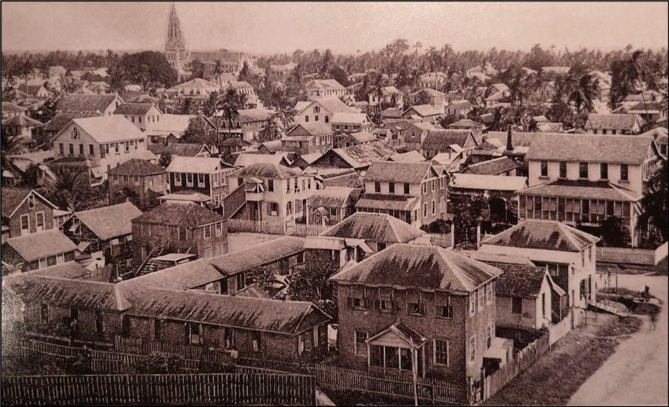 Figure 1 The Colonial Port City of Georgetown in 1890. From City of Wooden Houses (p. 20), by C. Davis, 2017, Merrell Publishers. Copyright 2017 by Merrell Publishers.
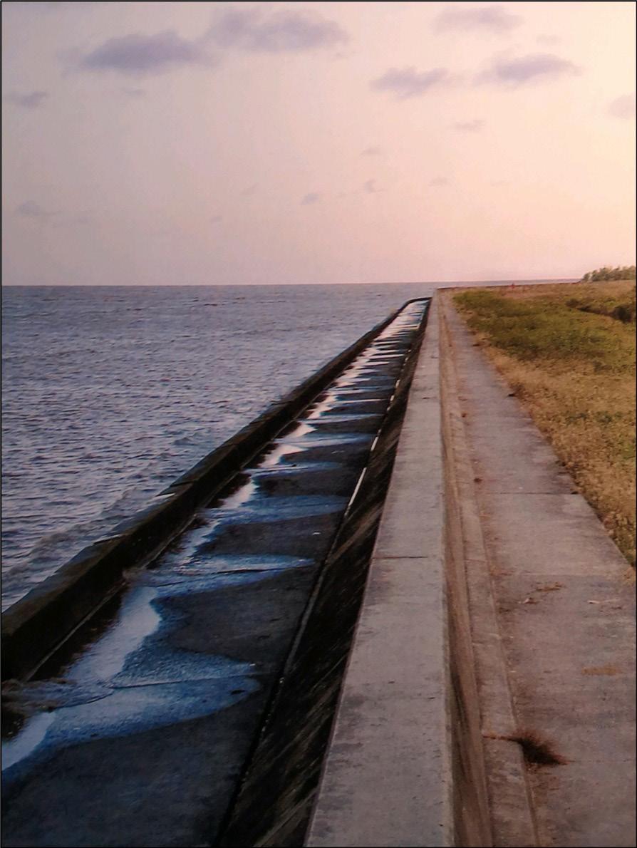
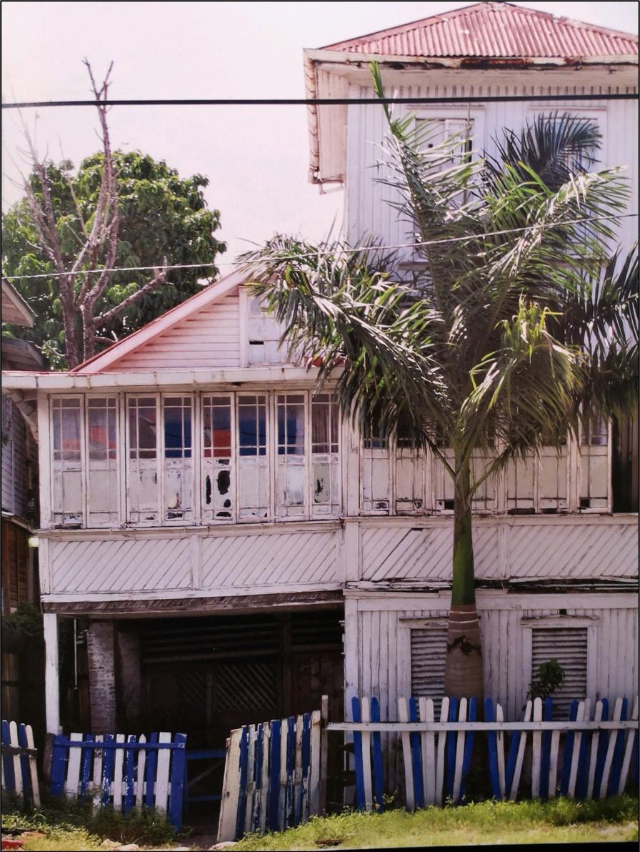
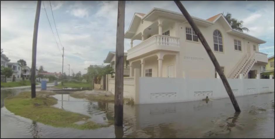
As a defensive measure, Dutch colonizers began the construction of a sea wall intended to prevent high waters from flooding the low-lying land in Georgetown; this wall was completed by the British in the 1950s and still stands today (Figure 2). Construction of the city buildings was partially inspired by British architectural styles, but the primary construction material was wood given its abundance in this area of the continent (Davis, 2017). Remnants of this colonial architecture can still be seen today (Figure 3).
Both aboveground and underground infrastructures were central in transforming Georgetown into a functional colonial port city. The operation of successful sugar plantations required efficient irrigation and drainage systems, which were especially crucial given that the 18th century Dutch colonizers who preceded the British noticed a constant threat of flooding near the coast (Davis, 2017). Although the Dutch have taken credit for the construction of these critical dams and canals, it was the enslaved people from Africa who were given the laborious task of building this infrastructure prior to the British abolition of slavery in 1833. In 1948, the Venn Sugar Commission speculated that enslaved people under Dutch orders and supervision were brutally relegated the task of moving approximately 100 million tons of waterlogged clay soil as a part of the construction process, with shovels being the most robust tool they had at their disposal (Rodney, 1981). After British emancipation, indentured labourers from the Indian subcontinent were tasked with maintaining these drainage systems, working under inhumane conditions and being subjected to exhausting environmental predicaments (Rodney, 1981). While all of these constructions paved the way for the drainage systems that exist in present-day Georgetown, the number of fatalities incurred during this vast undertaking remains undocumented (Davis, 2017).
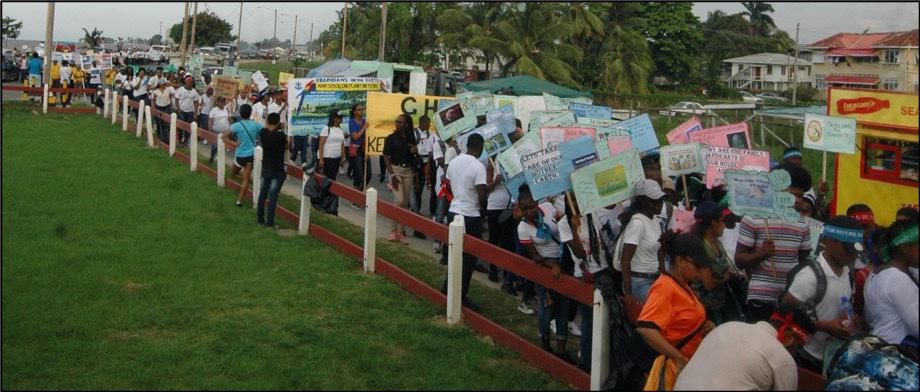
Moving forward to the year 2019, the young people of Guyana took to the streets of Georgetown in support of urgent climate action. A newspaper article published by Kaieteur News (2019) describes how groups of schoolchildren, university students, non-governmental organizations, and “hinterland participants” all marched as one collective force in an attempt to make the “adult world” understand the severity of climate change. Notably, the Guyanese government was absent at the march, even though they are responsible for combatting the nationwide infrastructural, environmental, and social losses incurred due to climate change. A photograph taken at this event shows hundreds of evocative signs being toted down the street, some of which reference a need to protect Guyana’s rivers (Figure 4).
2019, https://www.kaieteurnewsonline.com/2019/10/03/school-age-guyanese-stage-climate-protest.
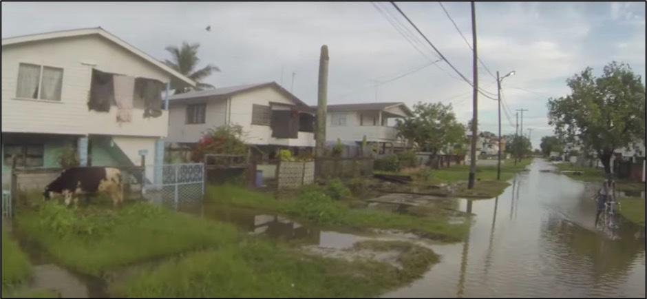
In response to climate change, environmental management measures involving infrastructure remediation and maintenance are very much needed in modern-day Georgetown. An informal journalistic video produced by a private civilian organization shows footage of the intense flooding that takes place in Georgetown after only two hours of rain (Real Guyana, 2013). The footage shows how homes built on wooden stilts in areas more susceptible to flooding have been abandoned due to decay, and how wooden electrical poles planted in the ground frequently become rotted and unstable in the wet conditions, which promotes the growth of wood ant colonies (Figure 5). While few people can be seen walking down the streets, people freely bike and drive their cars through the ankle-deep floodwater, almost as if they have adapted to the floods out of necessity. In addition, the footage shows cows grazing in flooded grass, thus contaminating the floodwater with their feces. Figure 6 illustrates the reality of people continuing to bike and cows continuing to graze regardless of the surrounding floodwater.
 Landmarks: The Journal of Undergraduate Geography // Given
Georgetown remains vulnerable to floods of this magnitude for several important reasons. Notably, its close proximity to the ocean—as ensured by European colonizers—has created a situation where 90% of Guyana’s entire population lives below sea level in order to profit off of the economies that have developed there over decades (Mullenite, 2019). While the sea wall has mostly kept the ocean out of Georgetown for decades, it is highly susceptible to incurring significant functional damage in the coming years as sea levels rise around the world. Additionally, the clay soil and level topography on which Georgetown sits are not conducive to adequate water drainage following the heavy rains so characteristic of this region of the world (Pelling, 1997). Natural water drainage methods will only become less effective as groundwater levels rise in the wake of climate change (Pelling, 1997).
The main contributor to the consistently severe nature of these floods, however, is the poorly maintained flood control infrastructure currently in place in Georgetown. In the Real Guyana video, the camera-person describes how the “pipes that were put in place to facilitate drainage of the road have clogged up with silt and weeds” (2013, 15:04). This has led to a situation where even short periods of rain generate catastrophic flooding conditions. One explanation for the inadequate drain cleaning has to do with the informal squatter settlements that have developed close to significant dams (Real Guyana, 2013, 22:10). The lack of adequate public housing in Georgetown has forced many civilians with lower incomes to take up residence in informal settlements that have remained unsanctioned by the Guyanese government since the 1970s (Pelling, 1997). Drains are thus supposedly inaccessible to the government, preventing them from maintaining the structural integrity of underground infrastructure. As such, the conditions have been created for Georgetown to become frequently inundated with contaminated floodwater (Real Guyana, 2013, 19:00).
Given that the maintenance of drains and public infrastructure is generally the responsibility of the government, it is important to ask—as civilians in Georgetown have been doing—why such crucial tasks are being ignored. The person behind the camera of the flood footage mused that one has “to wonder about the quality of civil engineers [they] have in [their] country” (Real Guyana, 2013, 15:35), and airs a deep-seated frustration that “nothing is ever done properly in this day and age” (Real Guyana, 2013, 14:22).
In one explanation, Pelling (1997) references the sociopolitical situation behind the continued flooding, describing the aforementioned insufficient public housing in Georgetown that has led to unkept drainage systems with entry points located within squatter settlements. Davis (2017) corroborates this point by discussing the disappearance of older colonial-style houses since the 1980s due to damage and decay, and how the “slow creep of modernism is reflected in the [new] glass-and-concrete buildings” (p. 18). In a different way, Mullenite (2019) targets the Guyanese government directly, arguing that climate change allows governments to assume a new genre of environmental control over their people. The ongoing neglect of flood infrastructure not only creates opportunities for the government to increasingly tax its civilians, but it also attracts foreign capital to help fund major infrastructure projects (Mullenite, 2019). Furthermore, keeping a nation’s civilians vulnerable to the effects of devastating floods prevents them from resisting powerful and unjust governmental structures, as they are justifiably more concerned with their own survival than challenging and organizing against authoritative ruling bodies. These power dynamics are likely to intensify as the grip of climate change
tightens on the nation of Guyana, bringing more intense storms and higher floodwaters. Civilians are very aware of these dynamics, and they have little faith in the competence of their own government to be able to mitigate widespread losses in environmental crisis situations (Mycoo, 2014).
Undoubtedly, certain Georgetown civilians are at a higher risk of incurring losses—financial or otherwise—to flooding than others. One’s vulnerability can be increased by any combination of social, economic, demographic, psychological, or environmental factors (Pelling, 1997). As previously mentioned, the plantation holdings that came together to form Georgetown so many decades ago have since been designated as wards, which are essentially neighbourhoods that each have different sociodemographic characteristics (Davis, 2017). As could be expected, wards and households with lower incomes are more likely to experience flooding in their homes, since infrastructure that can protect against flooding is generally more costly (Pelling, 1997). Such infrastructure includes concrete barriers around one’s home, tightly enclosed ground floors, or strong stilts upon which a house sits. Another important trend is the ability of homeowners to be able to raise the ground level of their home through expensive engineering methods, whereas civilians living in homes they rent do not have this conservation option (Pelling, 1997). Those living in poverty are further vulnerable to the effects of flooding since they have to miss days of work in order to mitigate flooding crises at home, and then pay for any damages incurred using the little money they have (Mycoo, 2014). Moreover, the bacteria in the floodwater can cause fatal illnesses, especially in infants (Pelling, 1997).
As governing bodies are not taking significant steps to fortify the city’s infrastructure in protection against climate change, Georgetown’s residents are being forced to take their own measures to protect themselves from the constant flooding and other environmental dangers. Those with adequate financial means have the ability to build concrete fences around their homes or elevate their yard levels using cement (Mycoo, 2014). A cheaper, more popular option for floodwater control is the use of sand and sandbags in massive quantities (Real Guyana, 2013, 2:08). While a seemingly obvious civilianmediated solution would be to move out of Georgetown, farther into the rural areas of the south, many young people and individuals with higher education have strong and well-founded desires to keep living in Georgetown (Mycoo, 2014). Since its first days under colonialism, it has been a major centre of economy, intellectual thinking, and culture, all of which people wish to be a part of in the present. The infrastructure of the city was put in place by enslaved people during brutal colonial times, and their descendants are now having to fight for its remediation in order to continue living in the city they have carefully created together since colonization. Instead of abandoning it, the residents of Georgetown chose to march for their city in hopes that political leaders might be pushed to take swift steps to protect the city.
The coastal city of Georgetown is maladapted to the harsh and unapologetic side effects of climate change, which has rapidly become a problem of the present as opposed to a future concern. A geographical location chosen by European colonizers for economic purposes has become a curse to the multi-ethnic and multi-racial population that lives there in the wake of a plantation-based economy. Materials and structures that formerly characterized this landscape are now deteriorating under the rule of a post-colonial government with no discernible plans for their remediation. Additionally, the sea wall built by the Dutch and the British during the 19th and 20th centuries has proven ineffective
at preventing colossal floods from drowning the city, and it is ultimately the poorest residents who pay the highest price for the short-sightedness of those with more power than them. It is crucial to note that, while there is a significantly greater amount of research targeted towards the effects of climate change on more affluent parts of the world, it is the poorer countries that will be most significantly impacted (Mycoo, 2014). This is especially true in the case of the Caribbean and Latin America, where there is far less climate change research in comparison to research about places in Asia (Mycoo, 2014). The best climate change mitigation efforts are fuelled by sound and sufficient research, and it is thus of great importance that geographers pay attention to landscapes like this one in their studies, as much time has already been lost for crisis mitigation in Georgetown, Guyana.
Davis, C. (2017). The colonial port city of Georgetown in 1890. [Photograph]. In City of Wooden Houses: Georgetown, Guyana (p. 20). Merrell Publishers.
Davis, C. (2017). A house in Georgetown built in a colonial architectural style. [Photography]. In City of Wooden Houses: Georgetown, Guyana (p. 49). Merrell Publishers.
Davis, C. (2017). The sea wall in Georgetown Guyana. [Photograph]. In City of Wooden Houses: Georgetown, Guyana (p. 14). Merrell Publishers.
Davis, C. (2017). Introduction: Georgetown and its building tradition. In City of Wooden Houses: Georgetown, Guyana (pp. 16–65). Merrell Publishers.
Mullenite, J. (2019). Infrastructure and authoritarianism in the land of waters: A genealogy of flood control in Guyana. Annals of the American Association of Geographers, 109(2), 502-510. https://doi.org/10.1 080/24694452.2018.1490635
Mycoo, M. A. (2014). Autonomous household responses and urban governance capacity building for climate change adaptation: Georgetown, Guyana. Urban Climate, 9, 134-154. https://doi.org/10.1016/j. uclim.2014.07.009
Pelling, M. (1997). What determines vulnerability to floods; a case study in Georgetown, Guyana. Environment and Urbanization, 9, 203-226. https://doi.org/10.1177/095624789700900116
Real Guyana. (2013, August 1). The Real Atlantis - Is Georgetown, Guyana a Sinking City? [Video]. Youtube. https://www.youtube.com/watch?v=Ew86PQgh3_Y
Rodney, W. (1981) Internal and external constraints on the development of the working people. In A History of the Guyanese Working People, 1881-1905 (pp. 1-30). The Johns Hopkins University Press.
School – age Guyanese stage climate protest. (2019, October 3). Kaieteur News. https://www.kaieteurnewsonline.com/2019/10/03/school-age-guyanese-stage-climate-protest
Landmarks: The Journal of Undergraduate Geography // Given
On the surface, the Eglinton Crosstown serves as a promising addition to Toronto’s lackluster transit network that would benefit the city in the long term. However, the effects of this multibillion-dollar project on racialized and working-class communities, particularly Little Jamaica in the city’s west end, necessitates investigation. This paper seeks to shed light on the area’s demographic shifts, lack of government protection for residents and business owners, and prioritization of corporate profits towards reducing Jamaican and working-class presence in favour of new white and middle-class residents. Though urban renewal, revitalization, and gentrification are arguably necessary to periodically improve the livelihoods of city residents, greater consideration of how anti-black racism and elitism manifest in seemingly benign city building projects is necessary to ensure equitable planning and governance.
Toronto should upgrade its inefficient and limited public transit network to facilitate movement across the automobile-congested and rapidly growing city. The Eglinton Crosstown LRT is one of the biggest public transit projects in Toronto’s recent memory. It would run along Eglinton Avenue, easing road congestion and providing residents with an accessible method of getting across the city. Despite the numerous benefits that this transit line would provide, the neighbourhood of Little Jamaica in Eglinton West has been detrimentally impacted by the project. Drawing on resident testimony, census data, and the registry of businesses operating in the area, I argue that increasing residential and commercial demographic shifts, lack of concrete government policies protecting current residents, and corporate influence over redevelopment are working in tandem to slowly displace current residents and erase the area’s ethno-cultural distinctiveness. In the following sections, I explain the local historical context, the Eglinton Crosstown project, and demographic shifts of the neighbourhood caused by rising property and rental rates. Then, I analyze government inaction and private interests to show how the recent decision to invest in public transit has been characterized by a lack of consideration for guarding residents’ interests against the harmful effects of gentrification. The government has prioritized commercial interests in the neighbourhood above those of residents who have been in the neighbourhood for generations. Finally, I conclude by summarizing the project’s shortcomings.
Located in the west end of central Toronto, Little Jamaica stands out among the city’s many neighbourhoods as one of the historical homes of Jamaican and other Caribbean immigrants to the city. The area runs along Eglinton Avenue West from Allen Road in the east to Keele Street in the west. Along with Bathurst and Bloor, as well as Jane and Finch, Little Jamaica is an ethnic enclave for the city’s Caribbean community who immigrated and settled there in the 1960s (Parris, 2019).
During that era, the Canadian government was deepening its ties with Jamaica and other Caribbean nations as part of the West Indian Domestic Scheme (Spurr, 2018). Over the next two decades, Canada accepted many non-European immigrants, including 100,000 Jamaicans (Spurr, 2018; Parris, 2019). Eglinton West soon became Canada’s largest Jamaican ethnic enclave and one of the largest in the world (Spurr, 2018). Jamaicans and other Caribbean immigrants who were not living in the area visited the neighbourhood to accommodate their commercial and cultural needs (Spurr, 2018; Parris, 2019). Little Jamaica’s cultural significance spans decades and serves as an important example of diasporic resilience and mutual aid against pervasive anti-black racism and xenophobia.
Discussing global Jamaican culture necessitates recognizing the historical significance of Little Jamaica. The area provided immigrants of Caribbean origin to have a place where they feel belonging; it has also been useful in terms of tourism. According to Spurr (2018), Little Jamaica’s output of reggae music was eclipsed only by Kingston, Jamaica. Reggae is a popular genre of music, and artists and enthusiasts once commonly visited Little Jamaica to purchase vinyl records and record music. More recently, however, the demographics of the neighbourhood have changed, as Canada’s main pools for immigrants changed, more black immigrants moved to the outer suburbs, and revitalization projects such as the Eglinton Crosstown began (Kurek, 2017; Spurr, 2018; Parris, 2019). Little Jamaica’s historical Jamaican population is threatened by several interrelated issues today.
The Eglinton Crosstown is a light-rail transit line currently under construction along the Eglinton Avenue east-west thoroughfare. With construction beginning in 2016 and slated for completion in 2022, the new line will become the Toronto Transit Commission’s (TTC) fifth rapid transit route (Metrolinx, 2020). The $5.3 billion project is being financed by Metrolinx and will be operated by the TTC once completed (Sherman, 2018; Spurr, 2018).
Metrolinx’s main policy document The Big Move: Transforming Transportation in the Greater Toronto and Hamilton Area shows that upgrading transit along Eglinton is a focus (Metrolinx, 2008, p. 24). One of the main goals is to ensure “that Toronto Pearson International Airport becomes connected to the regional transit network” (Metrolinx, 2008, p. 24). The document mentions the Yonge-Eglinton intersection as one of “Toronto’s five urban growth centres” and criticizes the city’s lack of east-west transit thoroughfares (Metrolinx, 2008, p. 61). Another goal is to have the Crosstown connect Durham Region to Toronto’s transit network (Metrolinx, 2008, p. 62).
Mayor Ford’s New Transit Proposal is another important document in the planning stages of the Crosstown. Although the mayor largely opposed public transit, he did see value in facilitating eastwest travel across the city (Burda & Haines, 2011, p. 1). While the initial planners of the project view the Crosstown as a necessary addition to the city’s current transit network, they provide minimal
Landmarks: The Journal of Undergraduate Geography // Abdel-Shehid
information regarding its effects on local communities. This neglect on the part of the municipal government, planners, and policymakers suggests that there is an absence of concern over the livelihoods of marginalized populations in the area.
A combination of resident testimony, census data, and local business registries indicate that people of Caribbean descent are no longer moving to Little Jamaica. Instead, they are moving to outer suburbs such as Brampton and Mississauga (Kurek, 2017). The largest ethnic group currently moving into Little Jamaica is of Filipino origin (Spurr, 2018). According to a local resident, the area’s earlier Jamaican population is being replaced by people of Chinese, Italian, Portuguese, Hungarian, and Filipino origin (Kurek, 2017). I argue that gentrification is playing an influential role in the demographic shifts currently underway in Little Jamaica. In a discussion of racial inequality and social change in Chicago, Hwang and Sampson describe gentrification as “the process by which central urban neighborhoods that have undergone disinvestments and economic decline experience a reversal, reinvestment, and the in-migration [emphasis added] of a relatively well-off middle- and upper middle-class population” (2014, p. 727). Official figures show a decline in Jamaican and black residents in the neighbourhood over the past ten years.
Local census data from 2011 shows that, in terms of ethnic origin, Jamaicans are Ward 15’s eighthlargest group, and black residents are the second largest visible minority population: 3,035 residents identified as Jamaican and 7,445 residents of Ward 15 identified as black (City of Toronto, 2014, p. 8). Census data from the same office in 2016 reveals that Jamaicans had fallen to the ward’s ninthlargest group while black residents remain the second-largest visible minority population: 2,515 residents identified as Jamaican and 6,760 identified as black (City of Toronto, 2018, p. 22). Although Little Jamaica covers a small portion of Ward 15, it is necessary to consider changes to the commercial make-up of the area in relation to these demographic changes.
The availability of special cultural amenities such as ethnic food stores, sites of worship, and other residents of the same ethno-cultural background is central to this conversation. Although affordability and access to public transit are consequential, access to special cultural amenities importantly permits prospective residents to feel a connection to their place of origin in their new community (Amar & Teelucksingh, 2015, p. 54). The arrival and increasing activity of private developers in the area are negatively affecting current local business owners (Kurek, 2017; Sherman, 2018). Composed predominantly of Caribbean-oriented businesses, the area historically contained many ethnic grocery stores, barbershops, hair salons, record stores, and ethnic restaurants (Spurr, 2018; Parris, 2019). Current residents are divided on the topic of Little Jamaica’s enduring character; some claim that the area has already lost a significant portion of its Jamaican population and many of its traditional businesses have closed down, while others recognize the displacement but are still hopeful that the Crosstown LRT will provide renewed vitality (Spurr, 2018).
Municipal neglect of resident claims to housing and commercial activity demonstrates a prioritization of redevelopment and profits over working-class and racialized livelihoods. In the Theatre District along
King Street, where the streetcar pilot project was in effect, complaints quickly led to the allocation of funds from the city to a local business budget, city-subsidized parking, and increased media attention (Spurr, 2018). Unlike Eglinton West, which is populated mainly by racialized and working-class residents, King West is populated mainly by white, upper-class residents. To avoid disproportionately harmful effects of gentrification, equitable planning and governance strategies must ensure that all residents, regardless of race or socioeconomic status, are treated equally. Although King West and Eglinton West are two different areas with distinct transit projects, preferential treatment based on location is unjust. Increased store closures and decreased neighbourhood accessibility have contributed to declining economic output for Little Jamaica.
Construction on the Crosstown LRT has greatly impeded the commercial activity of local businesses so that residents have difficulty paying rent for both residential and business responsibilities. Along the project’s entire 19-kilometre stretch, there is reduced lane availability and minimal on-street parking (Sherman, 2018; Spurr, 2018). This has led to increased congestion and travel times, and has also reduced the ability for potential customers to visit local shops. Metrolinx, the municipal government, and some Business Improvement Areas (BIAs) along the construction route have sought to encourage commercial activity through their “Experience Eglinton” program (Spurr, 2018; Metrolinx, 2020). As another means to encourage commercial activity in the area, BIAs on Eglinton have received $10,000 from Metrolinx (Spurr, 2018). If these provisions are in place and the government claims that they are helping residents, why are people leaving the area and citing difficulty to conduct business? Josh Colle, the Councillor for Ward 15 Eglinton-Lawrence from 2010 to 2018, had actively protected the interests of the community. He had offered suggestions on how to alleviate the construction process, including “temporarily deferring commercial taxes, waiving fees for street events, offering financial relief to businesses behind construction hoardings, providing free parking, and staging Nuit Blanche events in the area” (Sherman, 2018; Spurr, 2018).
However, Little Jamaica is also noteworthy in discussions of performative disingenuous protections of historically significant neighbourhoods. In 2015, due to the area’s deep ties to reggae music, Colle led the community to paint a mural in a local alley and renaming the alley “Reggae Lane” (Kurek, 2017; Spurr, 2018). Some residents of the community feel this is a failed attempt at commemoration since the neighbourhood no longer retains this ethno-cultural feature in the present day (Spurr, 2018). Despite this commemoration, the laneway is not conducive to commercial activity or cultural gatherings as the only change to the surrounding area was the mural (Taekema, 2015). While the city made an effort to commemorate the area’s history, it did not provide support for local businesses to expand commercial activity into this area and reap some profit during the construction period. Further investment in the area would help local business owners attract customers to their stores during this turbulent time characterized by layoffs, cutbacks, closures, and outward migration. The community would greatly benefit from the support of the municipal government.
Construction on the Crosstown LRT and accompanying private development has led to an increase in land value so that many historical residents are unable to afford to live and work in Little Jamaica. All five of the Crosstown’s stations in Little Jamaica will be underground (Metrolinx, 2020). The area comprises primarily two-to-three-storey mixed-use buildings (Spurr, 2018). The
stops and stations in the area will be built on a mixture of vacant lots purchased from previous landowners (Metrolinx, 2020). As more developers begin their work around the area, there is an increasing likelihood that existing smaller structures will be torn down and replaced with larger, more expensive developments (Spurr, 2018). As the city prepares for the Crosstown LRT and changes local zoning policy to permit the construction of mid-rise developments, developers will be able to construct eight-to nine-storey buildings (Sherman, 2018; Spurr, 2018). While The Big Move mentions the term “housing” once (Metrolinx, 2008, p. 2), Mayor Ford’s proposal does not mention it all.
Due to the relationship between public transit and housing, there should be more insight into how the two are related and how changes to one will cause changes in the other. Amar and Teelucksingh’s discussion of the relationship between housing choice and access to transportation suggests that the dominant factor in housing choice is affordability, which is closely linked to access to public transit (2015, p. 53). Residents will find themselves forced to choose between leaving the area or downgrading their residences and businesses. While Little Jamaica’s residents of the past 50 to 60 years were able to afford to live there, the construction of the Crosstown LRT and subsequent private development are working in tandem to raise the price of living.
There are other factors that dictate the relationship between housing choice and access to transportation, including proximity to transit, the most influential factor after affordability (Amar & Teelucksingh, 2015, p. 54). Many working-class communities do not have the financial resources to afford two automobiles, or even one. Using public transit as a means to travel outside of their neighbourhoods is their only option. However, this is only part of the story in Toronto, as housing in proximity to the subway is generally less affordable than housing at a further distance from the subway (Amar & Teelucksingh, 2015, pp. 54). There is a relationship between higher socioeconomic status and proximity to rapid transit lines in Toronto, where the past few decades have seen increasing income inequality and greater population without access to the subway (Hulchanski, 2007, pp. 1-2). It is evident that the Eglinton corridor will follow trends along other transit routes, where those in close proximity are largely higher-income and often white. Although the Crosstown LRT is not a subway route akin to the TTC Line 1, Line 2, and Line 4, it would be separate from road traffic, be partially underground, and increase mobility across the city (Metrolinx, 2020). Residents along the Eglinton corridor will benefit from this project, but if the working-class and black residents of Little Jamaica have been displaced, then not all residents will have equally benefited.
Toronto is considered to be one of the most diverse cities on the planet. Little Jamaica’s ethno-cultural composition contributes to this diversity. Jamaicans may have been the dominant population in the past half-century, but they were not the only group residing in the area. Other people of Caribbean origin and people from outside the region have also called Little Jamaica home. Regardless of ethno-cultural origin, people will move around and settle where it is most convenient for them. In the present day, incorporating the Eglinton Crosstown into the current regional transit network is a means to facilitate travel around the region. Lack of Jamaican or Caribbean interest in and ability to move to the area, insufficient and ineffective government protections, and developers occupied by corporate interests are leading to changing demographics. Areas undergo changes all the time with new people moving in, new structures being built, and new policies coming into effect and changing the social fabric. The
visibility of Bathurst and Bloor’s black community has nearly been eradicated due to gentrification, and Jane and Finch is rarely the focus of city-wide megaprojects. Other ethno-cultural areas such as Little Italy and Chinatown regularly receive support from municipal government, but the same cannot be said for Toronto’s most notable black neighbourhoods (Spurr, 2018). Ultimately, until the bodies of black working-class immigrants are valued to the same extent as white, upper-class Canadians, similar occurrences will persist.
Amar, A. K., & Teelucksingh, C. (2015). Environmental justice, transit equity and the place for immigrants in Toronto. Canadian Journal of Urban Research, 24(2), 43-63. www.jstor.org/stable/26195291
Burda, C., & Haines, G. (2011). New transit plan for Toronto: Analysis and recommendations. Pembina Institute. http://www.pembina.org/pub/2186
City of Toronto. (2014). City of Toronto ward profiles – 2011 National Household Survey: Ward 15 –Eglinton-Lawrence. https://www.toronto.ca/wp-content/uploads/2017/10/9729-City-Planning-Ward-15NHS-Profile-2011.pdf
City of Toronto. (2018). City of Toronto ward profiles – 2016 Census: Ward 15 – Eglinton-Lawrence. https://www.toronto.ca/wp-content/uploads/2018/05/8efa-City_Planning_2016_Census_Profile_2014_ Wards_Ward15.pdf
Hulchanski, J. D. (2007). The three cities within Toronto: Income polarization among Toronto’s neighbourhoods,1970-2005. University of Toronto.
Hwang, J., & Sampson, R. J. (2014). Divergent pathways of gentrification: Racial inequality and the social order of renewal in Chicago neighborhoods. American Sociological Review, 79(4), 726-751. www.jstor.org/ stable/43187561
Kurek, D. (2017, January 12). Is Toronto’s Little Jamaica still a Jamaican neighbourhood? Toronto.com https://www.toronto.com/news-story/7053325-is-toronto-s-little-jamaica-still-a-jamaican-neighbourhoodMetrolinx. (2008). The Big Move: Transforming transportation in the Greater Toronto and Hamilton Area. http://www.metrolinx.com/thebigmove/Docs/big_move/TheBigMove_020109.pdf
Metrolinx. (2020). Eglinton Crosstown. http://www.thecrosstown.ca
Metrolinx. (2020). Eglinton Crosstown LRT. http://www.metrolinx.com/en/greaterregion/projects/crosstown.aspx
Parris, A. (2019, September 27). Remembering Little Jamaica: This new film pays tribute to a disappearing Toronto neighbourhood. CBC Radio-Canada. https://www.cbc.ca/arts/remembering-little-jamaica-this-new-film-pays-tribute-to-a-disappearing-toronto-neighbourhood-1.5300174
Landmarks: The Journal of Undergraduate Geography // Abdel-Shehid
Sherman, J. (2018, May 10). Can Little Jamaica survive, or will gentrification get the better of the vibrant neighbourhood? TRNTO. https://trnto.com/can-little-jamaica-survive-or-will-gentrification-get-the-betterof-the-vibrant-neighbourhood
Spurr, B. (2018, March 24). In a city desperate for more transit, for Toronto’s Little Jamaica it could be bad news. Toronto Star. https://www.thestar.com/news/gta/2018/03/08/in-a-city-desperate-for-more-transit-fortorontos-little-jamaica-it-could-be-bad-news.html
Taekema, D. (2015, September 19). Side street revitalization honours Toronto’s role in reggae. Toronto Star. https://www.thestar.com/news/gta/2015/09/19/side-street-revitalization-honours-torontos-role-in-reggae. html
Romani people, a distinct ethnic group that has lived throughout Europe since the 11th century, are recognized as one of the poorest and most discriminated against populations in Europe (Diop, 2014). They are often referred to as “gypsies,” an offensive term that alludes to their history as travelling communities and serves to reinforce the notion that Romani are intrinsically nomadic and lack connection to their place of living, even when they have remained stationary for generations. This paper uses Bauman’s theory of immigrants and refugees as “strangers in our midst”—dangerous internal threats to maintaining state security and identity—to argue that the casting of Romani as “nomads” both confounds and threatens the current state-based system of world order and identity. By examining the experiences of both EU-citizen and non-EU-citizen Romani in claiming refugee status in Germany, Italy, and Canada from the 1990s through the 2010s, this paper argues that the casting of Romani refugees as “bogus refugees” has resulted in their claims being overwhelmingly rejected.
The Romani people, a distinct ethnic group living within many, if not most, European countries broadly trace their origins to India when they began migrating north following the expansion of the Ghaznavid Empire during the 11th century (Diop, 2014). Since then, they have experienced virtually constant discrimination and exclusion throughout Europe, with practices such as ear cutting and branding becoming a commonplace way of identifying Romani within a country. During the Holocaust, known in Romani communities as the Porjamos (“The Devouring”), Romani suffered mass internment in concentration camps alongside Jewish people. An estimated up to 1.5 million Romani were killed during this period, representing 70-80% of the European Romani population (Diop, 2014). Today, Romani people are recognized as one of the poorest, most discriminated against, and least “integrated” ethnic population in Europe (Sigona & Vermeersch, 2012). Why, then, have Romani seeking asylum in Western countries overwhelmingly experienced a denial of the legitimacy of their claims?
This paper will argue that Romani have been cast as generalized population of “bogus refugees” and “poverty migrants,” which has occurred due to their characterization as naturally geographically unbounded nomadic people, in conjunction with a general inability to conceptualize ideas such as citizenship, homeland, and discrimination outside of the nation-state framework. To make this argument, I examine the experiences of non-EU citizen Romani claiming asylum in Germany and Italy
on the basis of war displacement during the Balkan Wars of the 1990s, and the experiences of EU citizen Romani claiming asylum in Germany and Canada on the basis of ethnic discrimination during the 2000s and 2010s.
In order to maintain authority, the nation-state requires the mostly unified support of the masses for legitimacy, which is only likely to arise if the masses feel not only a common similarity with their fellow countrymen, but also a shared dissimilarity towards those outside. Thus, in-group and outgroup categories are a necessary component of the nation-state project. However, Bauman (1992) posits that, in order for the state to continue being effective, nationalism must at once be constant and inviolate yet always capable of demise, because the human condition tends towards ambivalence and inaction without the presence of constant threat. As such, it is not enough to merely have an external enemy; a nation must also have internal enemies. Bauman terms these the “stranger in our midst”—someone who is geographically close but does not share “our” values. Consequently, these strangers represent the ultimate threat to us because they can corrupt our way of life, while we are unable to prevent them due to their existence within the borders of our nation-state (Bauman, 1992, p. 687). Thus, we must always be suspicious of any sign of otherness. Most importantly, we must rout out ambivalence within ourselves and our communities such that our truth becomes the truth, lest there be room left for the influence of their truth.
Following the logic of Bauman’s theorization, immigration in general thereby represents the ideal opportunity for the proliferation of the stranger, leading to increased scrutiny towards them. Refugee claimants become even more suspect than regular immigrants due to a perceived lack of documentation, the urgency of their claims putting pressure on “due process” and potentially causing threatening aspects of their character to be missed, and the nature of crises causing an increased number of claimants in a short period of time so that it becomes a “wave” of foreign people with foreign customs “flooding” into “our” country (Mountz et. al, 2013). Because of this, state narratives often stress the potentially disastrous, even fatal or security-comprising, outcomes of accidentally accepting such a bogus refugee as justification for strict policies (Mountz et. al, 2013). As such, being labelled a “bogus refugee” can have significant consequences to the acceptance of a person’s refugee application, their perception and status within the global community, and—perhaps most impactfully—the communities within which they settle. Sigona (2003) notes that refugeehood is intrinsically linked to the idea of forced migration from one’s homeland. The consistent labelling of Romani people as “gypsies” or “nomads,” terms that imply an inherently transitory nature and way of life, is of considerable importance to Romani experiences of refugeehood; it suggests they are lacking a homeland from which they could be made stateless. Thus, to be Romani is to be by default a bogus refugee.
One example of how Romani people are by default seen as bogus refugees can be seen by examining Germany and Italy’s treatment of asylum-seeking Romani people from the Balkan region who are not EU citizens. Throughout the 1990s and early 2000s, continued conflict and ethnic discrimination in the Balkan region led tens of thousands of people, mostly from Kosovo, to flee the area. Those displaced received refuge in countries throughout Europe, including Italy and Germany. Amongst them was a
Landmarks: The Journal of Undergraduate Geography // Wilsonsizeable population of Romani people who had been pushed back into Kosovo by Serbian authorities after attempting to flee attacks from returning Albanian forces, and had therefore faced persecution from all sides during the war. However, despite the fact that the vast majority of Romani had lived at least one full generation in the Balkan area, they continued to be thought of primarily as nomads by state institutions and society more broadly (Sigona, 2003). This caused their status as victims to largely be ignored because they were considered neither Kosovan nor Albanian (Sigona, 2003).
In Germany, this resulted in more than two-thirds of Romani never receiving finalized refugee status but instead being given Duldung Duldung, which literally translates to “toleration,” is a grey legal category where the person is understood to be required to leave the country, but their deportation has been temporarily suspended. Duldung status is specifically designed to be a temporary measure and is typically used for asylum seekers whose claims have been denied but who cannot yet be returned to their country of origin. Yet many Balkan Romani lived in Germany as Duldung for years without access to social welfare benefits, having to go through government review of their status every six months. Thus, Romani lived under the constant threat of deportation while also facing the mental and social burden of having been unequivocally rejected from inclusion in Germany. Meanwhile, non-Romani Kosovans and Albanians were largely given refugee status (Castañeda, 2015). This demonstrates how the official classification of Romani as nomads resulted in their differential treatment within a larger refugee group; their claims were being rejected even when the group’s victim status as a whole was largely recognized as legitimate.
Returning to Bauman’s theory, I argue that Duldung functions as an official transitory status that amounts to the government officially designating a person as a stranger. Thus, by labelling the majority of Romani from the Balkan region Duldung, the German government perpetuates the link between being Romani and not belonging both on an institutional and a cultural level. The unusual length of Romani remaining in Germany, such that people found permanent jobs and houses, and thousands of Romani children were born and completed years of schooling, makes them a far more permanent— but officially non-permanent and non-desired—group than other refugee groups. As such, Germany’s treatment of Balkan-fleeing Romani was unique, and evidently informed by their characterization as nomads unable to claim connection to, and thus legitimate loss stemming from, the Balkan Wars. At the same time, the German government’s legal treatment and classification reinforced the notion of Romani as transient nomads and consequently bogus refugees.
Italy took a somewhat different, yet similarly discriminatory, approach. There is a relatively large population of Italian-born Romani who have traditionally been housed in government-authorized and unauthorized camps physically separated and usually located on the far outskirts of cities (Sigona, 2003). The European Commission against Racism and Intolerance reported that this segregation “appears to reflect a federal approach of the Italian authorities which tend to consider Romani as nomads and wanting to live in camps” (ECRI, 2002, n.p.). This is echoed in regional laws across the country, for Romani matters have been by custom the responsibility of local governments, which guarantee “the right of nomadism” under clauses with titles such as “in defence of Gypsies” (Sigona, 2003, p. 76). These camps were a key settlement site for the at least 10,000 Romani who were estimated to have fled the Balkans in the spring and summer of 1999. Notably, neither Italian authorities nor most of the organizations that are crucial to supplying these camps discern between the Italian-born and foreign-born Romani, but instead label them all indiscriminately as “nomads”
(ECRI, 2002). Thus, rather than being recognized as refugees fleeing devastating wars, the Balkan Romani population were normalized and portrayed as essentially doing what Romani people “do”: moving from place to place. A prominent Italian general summed up this sentiment when asked to comment on the recent influx of refugees coming into Italy on a talk show in 1999, replying, “on those boats there are bogus refugees who want to take advantage of our generosity. They pretend to be Kosovans, but they are nomads!” (as cited in Sigona, 2003, p. 74). Overall, Italian policy and public sentiment illustrate the depth to which this characterization of nomadacy, or a perceived nomadic way of living, is thought to be an intrinsic and vital part of Romani identity. It also demonstrates the impact such labelling has had on policy. This is true not only for refugee Romani who are, even if not by choice, displaying transitory behaviour, but also on Italian-born Romani who have never migrated.
The conditions of the Italian Romani camps are considerably worse than the standard of living found in Italian cities, with some camps lacking running water, electricity, and schools. (Giuffrida, 2018). As such, it is hardly surprising that a considerable number of foreign-born Romani chose to leave Italy (Sigona, 2003). However, this forms part of a self-confirming cycle whereby Romani are seen as frequently moving and thereby inherently nomadic in nature. This makes them “undesirable” or “bogus” refugees, thereby causing governments to enact policies that encourage them either to return to their country of origin or to move to another country. In turn, when Romani people do move, they inadvertently confirm their nomadacy and justify the receiving countries’ belief that they were false refugees all along. Sigona (2003) notes that this has enabled countries such as Italy to deflect domestic and international criticism of their treatment of Romani refugees while maintaining their own generous “Western saviour” image.
The Treatment of Romani with EU Citizenship: Germany and Canada Immigration, and especially the granting of refugee status, is a highly complex process whereby the receiving country, usually of the Global North, supposedly must balance internal concerns such as security and economics with their moral duty to aid those in need of help. Of particular concern is the supposed “unknown-ness” of these refugees whose motives for seeking asylum are potentially a ruse to gain entry into the country (Mountz et. al, 2013). Thus, a key component of the asylumseeking process is assessing the claimant so that the state feels satisfied in knowing the claimant’s character and values in addition to the validity of their claims. This often manifests in an expectation that claimants replicate a “migration-to-liberation” narrative (Murray, 2014, p. 132). In this narrative, refugee claimants depict their home country as something they are deeply attached to, but which is backwards and discriminatory, causing them to seek safety in the civilized social utopia of the country they are applying to (Murray, 2014). Thus, refugees are expected to demonstrate a clear narrative that is sympathetic, relatable, and fitting easily within pre-existing conceptions. The construction of Romani as “nomadic,” then, essentially represents the opposite of what the refugee process is seeking. Their supposed lack of attachment to a homeland represents something fundamentally unrelatable in a world where conceptions of the nation-state hold primacy. In this way, Romani represent not simply a foreign group to “our” country, but a foreign group to all countries.
This analysis may shed light on another aspect of how the construction of Romani as a geographically unbounded people affects their refugee experiences. Many thousands of Romani from Eastern Europe have attempted to claim refugee status on the basis of discrimination within their country of origin.
Landmarks: The Journal of Undergraduate Geography // Wilson 31
In 2012, a neo-Nazi rally of over 2,000 people was held in a Czech town with slogans such as “Gypsies, you’ve fucked up” and “Let’s stop gypsy terror” (Diop, 2014, p. 70). Amnesty International and Human Rights Watch both note that this is neither an isolated incident nor a problem specific to Czechia, but in fact is a widespread problem occurring in many Eastern European states (as cited in Diop, 2014). Discrimination against Romani occurs at a governmental and administrative level throughout Europe, with reports of forced sterilization, widespread educational segregation, and medical segregation (Diop, 2014).
The racism and persecution faced by Romani in Europe is “clearly recognizable as systemic in nature,” which “in itself ought to qualify them as refugees” within the parameters laid out in the Geneva Convention Relating to the Status of Refugees in 1951 (Levine-Rasky et al., 2014, p. 69). Yet, Germany has maintained that these Romani are “EU members with no proof of political persecution, making them ineligible for refugee status” (Castañeda, 2015, p. 94). Instead, they have been labelling them as “poverty migrants,” which is different from labour migrants because there is an assumption that not only are they looking for work, but also that they are seeking the significantly higher welfare benefits in Germany as compared to their country of origin. On this basis, Germany and an increasing number of other Western European countries have begun forcibly expelling Romanian and Hungarian Romani even though their EU citizenship legally entitles them to free movement and settlement. The perception of Romani people as continually migrating for better opportunities has, somewhat ironically, contributed to the restriction of their physical movement throughout Europe.
However, the narrative that EU status protects Romani from discrimination continues to dominate discussions of EU-citizen Romani refugees. For example, after a significant increase in asylum claims from Romani-Czechians in 2009, then Canadian Minister of Citizenship and Immigration Jason Kenney defended a visa restriction on Czech citizens by saying that European asylum claims made no sense because they could easily move to 26 other countries in the EU. He instead referred to them as “economic migrants jumping the queue, by going through the backdoor of the asylum system” (CTV News, 2009). In fact, the Canadian government was so convinced of the bogusness of overwhelmingly Romani Eastern European refugee claims that they revamped the entire Canadian refugee claim process to try and restrict their claims. Bill C-31, Protecting Canada’s Immigration System Act, was tabled in February 2012 under the argument that the existing system had been “crippled by an ever-increasing number of new unfounded claims” (Government of Canada, n.d., n.p.). The legislation gave the Ministry of Immigration the power to create “designated countries of origin,” a list of countries that “do not normally produce refugees and respect human rights” (Government of Canada, n.d., n.p.). Hungary, the Czech Republic, the Slovak Republic, and Croatia were all immediately included on the list, with Romania being added in 2014. Minister Kenney directly linked the implementation of this policy with the curbing of claims from the “European countries that are the primary source of false asylum claims” (Boesveld, 2012, n.p.). Thus, although Canada did purport to recognize discrimination towards EU-citizen Romani refugees as a legitimate claim for asylum, their stance was that these countries had fair state systems in place and if Romani felt otherwise, their EUcitizenship gave them the option to leave.
Considering the widespread and systemic nature of Romani discrimination, how could the Canadian
government have missed the fact that Romani people could not simply move to another EU country? I argue that this is the result of the Canadian government’s over-focus on the national scale, which is demonstrated by the fact that the information used to add countries to the designated country list comes solely from country-specific reports, with no analysis of conditions at a broader regional level (Diop, 2014). Without analysis beyond the scale of the nation-state, each country’s policies are viewed as separate and unrelated, thus causing a general failure to recognize the fundamentally transnational nature of discrimination against Romani people.
The focus on the nation-state is also important to understanding why the construction of Romani people as nomads has caused so much social exclusion and discrimination throughout history. Eliassi (2016) notes that statelessness is perceived as something that is experienced by individuals facing unusual circumstances, or sometimes by ethnic groups claiming the separation of what they deem to be their homeland from an existing state. Beyond this, she argues, statelessness on a collective level is inconceivable within a system where people’s individual and group legitimacy is derived from their association with a state. This is particularly heightened for the Romani people, who have existed in over 40 countries for centuries, have never had a distinct homeland, and have not organized a notable homeland movement (Sigona, 2003). Similarly, Gill (2010) suggests that not only is the “refugee” category contingent on nation-state sovereignty, but the legitimacy and effectiveness of the worldwide system of nation-states itself is bolstered by the “simultaneous objectification and abjection of those unfortunate enough not to belong to a nation-state community” who are consequently depicted as lacking something that only a nation-state can provide (p. 626). As such, it seems clear that Romani are discriminated against by states precisely because they are seen as nomads; they not only exist outside of the nation-state system but actually threaten its very construction.
As a result, countries engage in a myriad of practices to avoid recognizing the systemic discrimination against Romani, because its acknowledgement would represent a tacit admission of the limits and failures of the nation-state system. Germany and Italy’s treatment of non-EU citizen Romani refugees from the Balkan Wars reveals how nomadacy is used to deny them refugee status on account of a lack of homeland and suggests that their movement is rooted in the practice of migration for economic betterment. Nomadacy has been similarly used by Germany and Canada to label Romani from EU countries as “poverty migrants” or “economic migrants” in the past 20 years, but with the added argument that their EU citizenship gives them too much privilege of movement for them to have legitimate refugee claims even though Western EU countries have launched several legal challenges to their right to move between countries and partake in social benefits. Overall, the narrative of Romani as a nomadic ethnic group without ties to a homeland has been absolutely crucial to their history of discrimination and their experiences in asylum-seeking.
Bauman, Z. (1992). Soil, blood and identity. The Sociological Review, 40(4), 675-701. https://doi. org/10.1111/j.1467-954X.1992.tb00407.x
Boesveld, S. (2012, April 22). Efforts to keep bogus Roma refugees out have failed: Jason Kenney. National Post. https://nationalpost.com/news/canada/efforts-to-keep-bogus-roma-refugees-out-have-failed-jasonkenney
Castañeda, H. (2015). European mobilities or poverty migration? Discourses on Roma in Germany. International Migration, 53(3), 87-99. https://doi.org/10.1111/imig.12166
CTV News Staff. (2009, July 15). Kenney defends visa rules for Czech nationals. CTV News. https://www. ctvnews.ca/kenney-defends-visa-rules-for-czech-nationals-1.416560
Diop, P. M. (2014). The “bogus” refugee: Roma asylum claimants and discourses of fraud in Canada’s Bill C-31. Refuge, 30(1), 67-80. Retrieved from https://link-gale-com.myaccess.library.utoronto.ca/apps/doc/ A376392545/CPI?u=utoronto_main&sid=CPI&xid=7c16da41
Eliassi, B. (2016). Statelessness in a world of nation-states: The cases of Kurdish diasporas in Sweden and the UK. Journal of Ethnic and Migration Studies, 42(9), 1403-1419. https://doi.org/10.1080/136918 3X.2016.1162091
European Commission against Racism and Intolerance. (2002). Second report on Italy. https://rm.coe.int/ second-report-on-italy/16808b582e
Gill, N. (2010). New state-theoretic approaches to asylum and refugee geographies. Progress in Human Geography, 34(5), 626-645. https://doi.org/10.1177/0309132509354629
Giuffrida, A. (2018, July 26) Italian police clear Romani camp despite EU ruling requesting delay. The Guardian. https://www.theguardian.com/world/2018/jul/26/italian-police-clear-Romani-camp-despite-eu-ruling-requesting-delay
Government of Canada. (n.d.). Designated countries of origin policy. Retrieved November 29, 2018, from https://www.canada.ca/en/immigration-refugees-citizenship/services/refugees/claim-protection-inside-canada/apply/designated-countries-policy.html
Levine-Rasky, C., Beaudoin, J., & St Clair, P. (2014). The exclusion of Roma claimants in Canadian refugee policy. Patterns of Prejudice, 48(1), 67-93. https://doi.org/10.1080/0031322X.2013.857477
Mountz, A., Coddington, K., Catania, R., & Loyd, J. (2013). Conceptualizing detention: Mobility, containment, bordering, and exclusion. Progress in Human Geography, 37(4), 522-541. https:// doi.org/10.1177/0309132512460903
Murray, D. (2014). The challenge of home for sexual orientation and gendered identity refugees in Toronto. Journal of Canadian Studies, 48(1), 132-152. https://doi.org/10.3138/jcs.48.1.132
Sigona, N., & Vermeersch, P. (2012). Editors’ introduction. The Roma in the new EU: Policies, frames and everyday experiences. Journal of Ethnic and Migration Studies, 38(8), 1189-1193. https://doi.org/10.1080/1 369183X.2012.689174
Sigona, N. (2003). How can a ‘nomad’ be a ‘refugee’? Kosovo Roma and labelling policy in Italy. Sociology, 37(1), 69-79. http://www.jstor.org/stable/42856494
Landmarks: The Journal of Undergraduate Geography // Wilson
Aisha Assan-Lebbe
This paper investigates the gendered and futurist dimensions involved in the production of the Navajo Nation as an extractive landscape. As with numerous sovereign Indigenous nations, the land of the Navajo Nation has been the site of intensive mining enterprises from the late 1940s through the end of the 20th century due to the Cold War impetus for nuclear armaments. While mining activities have come to an official halt, the legacy of this toxic industry remains uncannily present in the life forms that inhabit this space, subjecting inhabitants of the Mesa to harmful and deleterious effects of war-time technologies. This paper concludes that destructive forces are the logical consequences of the “production” of a resource landscape. In particular, the contamination of the landscape has subverted the role of space as witness and active agent throughout history while undoing intergenerational solidarities within the Mesa.
In a series of essays written shortly before his death, Walter Benjamin notes, “even the dead will not be safe from the enemy if he wins” (Benjamin, 1968, p. 255, emphasis original). This quote powerfully illustrates the myriad entanglements of human survival, the writing of history, and its uses (and abuses) over time. Situated on the largest Indigenous reservation in the United States, the Navajo Nation is a powerful case-in-point of precisely this conundrum. Straddling the borders of Utah, Arizona, and New Mexico, the southwestern landscape is famous for the presence of Monument Valley, scenic vistas, and majestic rock formations.
As a tourist site, it holds material and symbolic significance to American cultural identity, having been featured prominently in many mid-20th century western films, including those by John Ford and Clint Eastwood. However, the 1940s saw the site’s emergence as a space amenable for intensive mineral and resource extraction. This prolific extraction is the debris of capitalist waste and violently uneven modernity that privileged the “potential” of earth minerals over human lives, drastically reshaping the land and lives of the Indigenous Diné tribe that has inhabited it since time immemorial. This paper will argue that the formation of the Oljato Mesa as a uranium landscape—which reached its zenith in the late 1940s—entailed the destruction of the conditions for the possibility of life and the interconnections of generations of Diné people. In addition to causing environmental degradation, mining practices have subverted what cultural geographers refer to as principal roles of the landscape—both witness and actor—actively recording and shaping history.
This paper first outlines the formal emergence of the Navajo Nation as a resource landscape at the height of the Cold War and in the succeeding years, tracing the mining practices that resulted in the transformation of the Navajo Nation into an extractive landscape, a process that occurred concomitantly with the attempted destruction of Navajo futurity. Borrowing from Deborah Bird Rose’s concept of “double death” and James Hatley’s neologism “aenocide,” this paper will illustrate the spatial dimensions of Indigenous futurity and intergenerational connectivity in this region, which the resource landscape especially targets. The paper then explores the connection between the seeping of modernity into the Cold War period and the consequences of the Oljato Mesa’s emergence as a resource landscape. Lastly, this paper contends that the slippage involved in the making of this landscape undermines the process of sedimentation, where the documentation of history and memory cannot occur.
Propelled by a Cold War impetus for nuclear armaments, the Monument Valley territory supplied critical materials to support the atomic weapons arsenal of the United States from the 1940s to the 1980s. Local demand for clean water in cities like Las Vegas further cemented the Oljato Mesa’s status as an extractive landscape, given the geographic proximity of these two regions. Once the site of Diné hunting grounds and land-based lifeways, the incursion of uranium prospecting brought increased federal interest in the land. This matter was further complicated by the prospect of increased sources of employment associated with the extraction of minerals, which were precarious, short-term, and unsteady, among other issues.
Critical historians have noted that the establishment of the Navajo Nation’s border coincided with federal recognition of it as a resource landscape (Iverson & Roessel, 2002, p. 134). Contrary to popular belief that Indigenous sovereignty led to the formation of the Navajo Nation Council, legal scholar David Wilkins asserts that the council was largely a product of the Secretary of the Interior (Wilkins, 2003, pp. 83-85). The Navajo Nation Council also affirmed the role of mining interests in shaping the political landscape, noting the discovery of oil as the impetus for the need of a new Diné governance body to help meet the “increasing desires of American oil companies to lease Navajo land for exploration” (Navajo Tourism Department, n.d.). The destructive influence of uranium on both the physical environment and human life forms contributed to the production of this cultural and political landscape.
The impact of mining upon the physical landscape of the Mesa is well-documented (Morales, 2012). After uranium mining was shut down, mines were abandoned without proper seals or caps, leaving 521 uranium mines open to contaminate local air and water (Morales, 2012). The Navajo Nation was littered with abandoned and open radon-emitting mine sites. Waste was dumped carelessly in unmarked piles where children could be found playing. For years, unsuspecting members of the Navajo Nation inhaled radioactive dust and drank contaminated well water, causing genetic mutations that resulted in cancer and other diseases at rates that twice exceeded the national average of the United States (Macmillan, 2012).
There is extensive literature regarding the extractive industries’ detrimental effects on the health of locals. Specifically, scholars such as Traci Voyles have explored the negative health effects on women and girls, including birth defects, reproductive anomalies, and spontaneous abortions (miscarriages) as reported by Navajo women. There are acutely gendered implications of the uranium industry (Voyles, 2015, 141). The production of this resource landscape entailed the literal destruction of the body politic. Even teenage Navajo girls have rates of reproductive cancers that are exceptionally high, exceeding the average of their national counterparts seventeen times (Macmillan 2012). As the main progenitors of new life, girls and women embody futurity, defined as “renewed or continued existence” (Oxford English Dictionary, n.d.). Since new life is tainted by the legacy of the nuclear arms race that has resulted in Navajo children being born with uranium in their urine, uranium mining in the Oljato Mesa is harmful to the continuity of human life.
The decay products of uranium, such as radon and radium, corporeally trouble Navajos as these materials are known to cause cancers (Macmillan, 2012). Voyles, a women and gender studies scholar, uses the racialized metaphor of zombies, originating from the Haitian Revolution, to describe the unabating influence of uranium on Navajo populations throughout time. Uranium is an undying material that has harmful and enduring effects on genes (Voyles, 2015, p. 4); it corporeally haunts the bodies of Indigenous women in this region. This landscape is thus witness to the unmaking of life and the amplification of death. Dana Powell’s framing of the Navajo Nation as a “landscape of power” signals the multivalent nature of potential in the Oljato Mesa. Here, power is doubled to include landscape destruction due to industrial capitalism while conferring mourning for the extinguishing of human life as lost potential.
This centring of destruction is consistent with what multi-species ethnographer Deborah Bird Rose calls “double death,” in reference to the cascading and intergenerational effects of extraction, the consequence of which extinguishes times yet to come (Rose, 2004). Double death invokes the temporal disjunction of death—a connection to the anthropogenic destruction caused by violent settler colonialism and capitalist expansion. Therefore, corporeal and environmental destruction are entwined. In a similar vein, philosopher of genocide and species extinction James Hatley coins the term “aenocide” to describe the killing of generations. He notes that with aenocide, “generations disappear, time as an articulation of a responsibility collapses, and no one remains who can carry on that specific line of responsibility. One finds here a time that cannot be mourned” (Hatley, 2000, p. 31). In fact, the idea of the destruction of time is an issue of mourning. According to Hatley, these death narratives are situated in place and belong to those who inherit and transmit them. In the ruthless advancement of industrial capitalism, however, the materiality of the Oljato Mesa has been undermined. Therefore, just as the body serves as an index of time, the landscape reveals the strata of time. The Oljato Mesa is hardly a plain surface upon which human events unfold.
The idea of the landscape has been articulated by influential cultural geographers such as Carl Sauer and Peirce Lewis. Sauer, in the seminal text The Morphology of Landscape, argues that the cultural landscape is concerned with “man’s [sic] record upon the landscape” (Oakes & Price, 2008, p. 103). Likewise, Lewis contends that history is preserved in the landscape, which he argues is “our
unwitting biography” (Jackson & Meinig, 1979, p. 12). Despite their obvious neglect of the materiality of landscape, these quotes illustrate the potency of the metaphor of landscape as text, positing that every landscape has a history that is intimately connected to memory—both of humans and of the land.
Diné bodies and land have been materially affected by the violent legacies of the European colonial project. The Diné people experienced killings and brutalities at the hands of Spanish colonizers (Powell, 2018), but the landscape figures into the history of Diné survival in taking on a timeless and monumental quality. The landscape also contains the toxic residues of uranium mining. The Oljato Mesa is not a separate or passive entity; rather, it is a living and endeavouring thing that serves as a witness to the transmission of memory and wisdom. In the context of the Oljato Mesa, however, the destructive impact of uranium mining has disrupted the role of landscape as an actor that is capable of both producing and transforming memory.
Uranium mining has undermined Navajo cultural recollection. The Oljato Mesa and the Diné tribe that inhabits it remember and tell stories through a rich oral tradition, thereby preserving the past and actively shaping the future. Seemingly inanimate objects are teeming with meaning and alive with history; atmosphere, minerals, and terrain are personified in Diné folklore (Powell, 2018, p. 14). Likewise, the enduring contestation of the Oljato Mesa is, in fact, a struggle over its past and future. A significant consequence of this destruction has been the subversion of futurity, legacy, and inheritance. In the struggle over control of the landscape, memory is not merely focused on the past but instead comprises the creation of the future. The landscape bears manifold traces of history; for the Oljato Mesa, it is witness to the ongoing conditions of colonialism.
The emergence of the Mesa as a resource landscape has disrupted the sedimentation of the past— namely, the legacies of dispossession and the violence of colonial conquest that befell the landscape. In the attempted destruction of Diné futurity, the land cannot serve as a witness to history and the landscape cannot be a refuge for history. Many scholars have grappled with the idea of colonialism being continuous. According to Powell, “ethnographies of these interstices and modes of resistance have exposed settler colonialism as an unfinished and open-ended project” wherein the narrative of modernity is inseparable from enduring legacies of colonial violence (Powell, 2018, p. 7). Indeed, the present is unsteady, haunted by residues of violence (Gregory, 2004). Thus, history has come to be understood through the extensive entanglements of colonialism and modernity. Despite this bleak reality, autonomy is consistently affirmed in the face of colonial conditions. While the Oljato Mesa is a space of hegemony, it is also one of Diné agency and reclamation. The framework of settler colonialism creates the conditions of possibility for disruption, which is evidenced through expressive arts and, as previously suggested, the presence of human bodies that disturb the teleology of reproduction.
Uranium mining from the late 1940s to the end of the 20th century has completely altered the symbolic and material landscape of the Oljato Mesa and the broader Navajo Nation. While mining at the site has technically ceased, the legacy of this industry remains active in Navajo land and bodies. Settler colonialism destroys to replace, and this is a landscape of destruction as much as it is one that produces. In particular, the gendered implications of the uranium industry are an assault on continued
Diné existence, as girls and women signal human continuity. The annihilation of times yet to come is a trademark of industrial capitalist modernity, given that the landscape is replete with toxins— the trauma of which is intergenerational and unabating. Settler colonialism’s logic of destruction, in tandem with forces of industrial capitalism, has shaped the literally undying process of this landscape’s production. Therefore, the destruction of the landscape at the hands of late modernity is a logical consequence of its production and emergence.
Benjamin, W. (1968). Illuminations. Harcourt, Brace & World.
Gregory, D. (2004). The colonial present. Blackwell.
Hatley, J. (2000). Suffering witness: The quandary of responsibility after the irreparable. State University of New York Press.
Iverson, P., & Roessel, M. (2002). Diné: A history of the Navajos. University of New Mexico Press.
Jackson, J. B., & Meinig, D. W. (Eds.). (1979). The interpretation of ordinary landscapes: Geographical essays. Oxford University Press.
Macmillan, L. (2012, March 31). Uranium mines dot Navajo land, neglected and still perilous. New York Times. https://www.nytimes.com/2012/04/01/us/uranium-mines-dot-navajo-land-neglected-and-still-perilous.html
Morales, L. (2012, April). For the Navajo Nation, uranium mining’s deadly legacy lingers. NPR. https:// www.npr.org/sections/health-shots/2016/04/10/473547227/for-the-navajo-nation-uranium-minings-deadly-legacy-lingers
Navajo Tourism Department. (n.d.). Navajo History. Discover Navajo. https://www.discovernavajo.com/ navajo-culture-and-history.aspx
Oakes, T., & Price, P. L. (Eds.). (2008). The cultural geography reader. Routledge.
Oxford English Dictionary. (n.d.). Futurity, n. In OED Online. http://www.oed.com/view/Entry/75863
Powell, D. E. (2018). Landscapes of power: Politics of energy in the Navajo Nation. Duke University Press.
Rose, D. B. (2004). Reports from a wild country: Ethics for decolonisation. University of New South Wales Press.
Voyles, T. B. (2015). Wastelanding: Legacies of uranium mining in Navajo country. University of Minnesota Press.
Wilkins, D. E. (2003). The Navajo political experience. Rowman & Littefield.
Landmarks: The Journal of Undergraduate Geography // Assan-Lebbe
The increasing impacts of climate change demands that cities proactively develop urban resilience: the ability to adapt to and recover from anticipated stresses to its social, economic, and physical infrastructure (Coaffee et al., 2018). However, the uneven climate resilience across New Orleans threatens its ability to recover from climate disasters fully. This paper will investigate how environmental racism and growth-oriented urban governance have socio-spatially concentrated local climate impacts on New Orleans’ low-income, racialized communities. Through historical analysis, this paper finds that continuous environmental racism has relegated New Orleans’s black population to low-lying neighbourhoods that were particularly vulnerable to Hurricane Katrina’s destruction. This socio-spatial climate vulnerability was compounded by the inequitable allocation of recovery funds and climate gentrification, which further displaced lowincome, black residents. Ultimately, New Orleans’s political approach to resilience fails to sustainably mediate the environmental and industrial processes that increase its vulnerability to extreme flooding, continually rendering marginalized communities the most vulnerable to future climate change destruction.
The increasing impacts of climate change demand that cities proactively develop resiliency to withstand future hazards. Urban resilience is defined as a city’s ability to adapt to and recover from anticipated stresses to its social, economic, and physical infrastructures (Coaffee et al., 2018). As the organization of the city simultaneously reflects and produces underlying socio-economic inequalities, some sections of the city are more resilient than others (Vale, 2014). Studying New Orleans, an inequitable coastal city facing rising sea levels and extreme flooding, this paper will discuss how environmental racism and growth-oriented urban governance have socio-spatially concentrated local climate impacts on lowincome, racialized communities. This paper will first examine Hurricane Katrina’s focused destruction of racialized, low-income neighbourhoods as a result of environmental racism: black residents of New Orleans have not historically garnered the same “right to the city” as their white counterparts— the ability to fully access urban resources without socio-spatial restrictions (Harvey, 2012). Next, this paper will discuss how the inequitable allocation of recovery funds perpetuates this racialized geography, followed by how climate gentrification exacerbates coastal displacement. Lastly, this paper will explore how New Orleans’s reactive approach to resilience fails to address the environmental and industrial processes that render the city vulnerable to extreme flooding.
While New Orleans’s geography as a low-lying delta city in a hurricane zone acutely exposes the city to sea level rise and coastal flooding, its level of climate risk is further intensified by its sociospatial particularities. The socio-economic variance in vulnerability, identified by Vale (2014), is exemplified by Hurricane Katrina’s disproportionately high impact on the black community. As a form of environmental racism, black residents have been concentrated in flood-prone residential areas with poorly-maintained levees (Elliot & Pais, 2006). Environmental racism is the varying exposure to environmental harm and access to resources that relies on and reproduces racial differentiation (Pulido, 2000). It is the systematic exclusion of racialized people from healthy environments and the increased exposure to hazards (Pulido, 2000). Those who tend to contribute the least to climate change, such as marginalized and low-income populations, tend to suffer its effects most severely (Coaffee et al., 2018). As a result of where they live, in addition to their lack of political clout and equitable access to resources, they are most likely to have their neighbourhoods destroyed by extreme weather events or to be deprived of food and medicine during a disaster (Vale, 2014).
As a consequence of historical settlement patterns tied to topography and real estate policies that bolstered racial segregation, people of colour and low-income residents have been more likely to live in low-elevation areas at higher risk of flooding. In the 20th century, early settlers and government officials expanded the inhabitable area of the city by draining the marshes and building levees and floodwalls (Colten, 2006; Fussel, 2007). The elimination of these coastal marshes, which form New Orleans’s natural defences against extreme flooding by absorbing excess water, significantly increased the devastating effects of Hurricane Katrina (Wang et al., 2014). As local wetlands were drained to enable urban development, developers began building more houses and businesses in flood-prone areas. Wealthy, white residents settled on the city’s elevated land created by natural geologic ridges, forcing lower-income, racialized residents to live on the undesirable low-lying swampland (Colten, 2006). These coastal areas formed the city’s first black neighbourhoods in Jim Crow New Orleans (Campanella, 2007; Elliot & Pais, 2006).
Racialized local zoning ordinances further excluded black residents from elevated neighbourhoods that remained predominately white. Black residents were barred from living in white enclaves, which further limited their housing options to historically black communities near the coast (Campanella, 2007). Even after federal courts deemed racial zoning laws unconstitutional in 1927, policies that supported racial segregation continued as they were replaced by zoning rules that sought to protect white single-family zones for middle-class residents (Elliot & Pais, 2006; Fussel, 2007). Once again, black residents were excluded from residing in white areas and were subsequently confined to flood-prone zones. From 1930 to 1968, these zoning ordinances supported “redlining,” the practice of refusing loans to residents living in neighbourhoods seen as a financial risk (Campanella, 2007). Redlining was applied almost exclusively to black areas. These policies prevented African-Americans from buying homes, setting up the current racial wealth gap (Colten, 2006; Fussell, 2007). While white families accrued wealth through homeownership, African-Americans did not have the same opportunity to invest and build equity in homes, forcing them to reside in inexpensive rental housing in racialized, flood-prone areas.
As such, black residents of New Orleans have not historically garnered the same “right to the city” as their white counterparts (Harvey, 2012). While white residents had their “right to the city” protected
by racially-restrictive covenants that secured their exclusive tenancy in desirable neighbourhoods, people of colour were denied the right to live in these neighbourhoods and were instead forced to live in less desirable and environmentally-vulnerable areas (Campanella, 2007; Harvey, 2012). Relegating black residents to unresilient areas ensured that they faced the brunt of the environmental devastation. By systemically excluding racialized people from healthy environments and increasing their exposure to climate hazards, New Orleans’s racialized housing pattern exemplifies environmental racism, as described by Pulido (2000).
New Orleans’s racialized wealth gap provides wealthier white residents with greater environmental safety than poor residents of colour, as they live in more expensive neighbourhoods with wellmaintained levees and have the financial means to leave during a disaster. As such, this varying resilience between different neighbourhoods and groups of people is linked to both topography and income (Vale, 2014). The government’s failure to equitably maintain flood-protection infrastructure and organize comprehensive evacuation plans has led to the increased vulnerability of poor and racialized minorities. The emergency evacuation plan established by the city and federal governments for 15,000 people was insufficient to provide for the 20,000 stranded residents (Elliot & Pais, 2006). The plan falsely presumed that many residents had the financial means and mobility to leave the city in advance of the hurricane, ignoring the racialized wealth gap and processes of environmental racism that placed low-income residents at the forefront of Hurricane Katrina’s destruction.
Coaffee et al. (2018) question whose interests are included in resiliency measures. The preservation of the levees near affluent white communities suggests the political prioritization of this group as the city’s valuable constituents (Fussell et al., 2010). As such, low-income and racialized communities are not equally considered in the development and implementation of resiliency measures. Not providing equivalent resilience for all neighbourhoods and residents of New Orleans indicates that there is an inherent socio-spatial hierarchy that privileges high-income and often white residents. Vale (2014) cautions that resilience can only be implemented as a valuable model and progressive practice if it is explicitly linked with helping disadvantaged groups. New Orleans’s resilience strategy does not follow this equitable model of resilience by prioritizing the safety and well-being of affluent white communities, furthering the disproportionate geographical impact of extreme flooding events on low-income and racialized populations along the coast.
Despite billions of dollars of recovery funds flowing into the city post-Katrina (Elliot & Pais, 2006), New Orleans’s legacy of historical racist housing practices has proliferated. Programs designed to rebuild the city after Hurricane Katrina have reinforced the racialized geography of local housing due to the inequitable allocation of recovery funds. Hurricane Katrina destroyed or severely damaged 80% of New Orleans’s housing stock, with reconstruction estimated to cost between 27 and 35 billion dollars (Finch et al., 2010). The federally-funded Road Home program was central to rebuilding efforts in New Orleans after Hurricane Katrina; however, the program disproportionately benefited white residents due to New Orleans’s legacy of residential segregation. As the value of Road Home grants reflected the pre-storm value of the home, homeowners in segregated white neighbourhoods with higher pre-storm values received more money. In contrast, those in predominantly African-American neighbourhoods received less, even for homes of a similar age and size (Fussell et al., 2010). The Bush administration
calculated payments according to a property’s market value, which garnered generous compensations for the owners of grand villas in the affluent Garden District, while residents with inexpensive coastal properties received meagre sums to rebuild (Petterson et al., 2008).
Black residents living in low-income coastal neighbourhoods benefited marginally from the program, as the costs to rebuild their homes remained financially significant. As such, the inequitable distribution of recovery funds in the Road Home program has made it more challenging for black families to return to their homes. Seventy percent of long-term white residents returned to New Orleans within a year after Hurricane Katrina; in contrast, only 42% of long-term black residents returned within the same period (Finch et al., 2010). This statistic explicitly demonstrates that black residents of New Orleans have not garnered the same “right to the city” as their white counterparts following Hurricane Katrina (Harvey, 2012). The Road Home program’s higher grants for white, affluent residents better protected their “right to the city” by making it easier for them to rebuild their houses and lives in New Orleans (Fussell et al., 2010; Harvey, 2012). By providing black, low-income residents with smaller loans, the program perpetuated their lack of resiliency and increased their vulnerability to future climate disasters, and they have been largely unable to recover from the environmental devastation caused by Hurricane Katrina (Robertson & Fausset, 2015). Thus, the national funds intended for broad‐scale recovery became instruments to further racialize the concentration of wealth.
Hurricane Katrina’s targeted destruction paved the way for climate gentrification in hurricanedamaged areas of New Orleans, widening the existing socio-economic disparity that increases the climate vulnerability of racialized populations. Climate gentrification is a subset of gentrification that is spurred by the redevelopment process following a climate disaster (Keenan et al., 2018). New Orleans’s climate gentrification has displaced even more of the minority and low-income residents who were initially forced from their homes, further infringing upon their “right to the city” (Harvey, 2012; Van Holm & Wyczalkowski, 2019). Climate gentrification follows the traditional pattern of stage model gentrification: the successive influx of increasingly affluent residents as upperclass amenities and housing increase the local costs of living, culminating in the neighbourhood’s middle-income occupation and low-income displacement (Shaw, 2008). Climate gentrification, prompted by extreme weather, greatly accelerates the entire process (Keenan et al., 2018).
Devastating physical damage has demolished entire neighbourhoods and displaced existing populations, making it easier for developers to assemble large plots of land that can be rebuilt (Petterson et al., 2008; Slater, 2008). Hurricane Katrina provided local developers with a natural wrecking ball for razing and redeveloping existing neighbourhoods (Keenan et al., 2018). Opportunistic real estate developers have swept into damaged neighbourhoods, buying inexpensive land and constructing resilient luxury housing. To maximize their profits, developers seek to garner the highest land use value by building expensive properties for high-income residents, paving the way for mass gentrification (Slater, 2008). This socio-spatial transformation has dramatically increased market rates, forcing low-income residents to move elsewhere (Johnson, 2011; Shaw, 2008).
The Journal of Undergraduate Geography // Livingston
New Orleans’s most vulnerable residents continue to experience Hurricane Katrina’s socio-spatial destruction as they are further displaced through climate gentrification, which perpetuates the local hierarchical “right to the city” that prioritizes the interests of high-income and non-racialized communities (Harvey, 2012). Fifteen years ago, the coastal area was almost entirely black; however, the proportion of African-Americans in the area dropped from 67% in 2005 to 49% in 2015 and is accelerating downwards (DeWaard et al., 2016). Forced out by an influx of young, white gentrifiers, low-income and often racialized residents have relocated to the suburbs (Robertson & Fausset, 2015). Historically black working-class neighbourhoods such as Bywater, Marigny, the Seventh Ward, and Freret have become whiter and more affluent (Finch et al., 2010; Fussell et al., 2010). Bywater, a previously low-income, black enclave located adjacent to the Lower Ninth Ward, lost 64% of its black population between 2000 and 2010 while simultaneously gaining 22% more white residents (Johnson, 2011).
The municipal government’s increase of the height restrictions along the waterfront will likely intensify the already-rapid process of climate gentrification. As of 2015, developers have been able to build taller properties along the coast, which makes building in the area even more desirable to real estate capitalists as the additional floors would increase the number of profitable units per building (DeWaard et al., 2016; Wang et al., 2014). This state-led process of “channelled reinvestment” (Stein, 2019) has been used by the city of New Orleans to aid in its socio-spatial recovery. Intended to spur redevelopment in the coastal areas most devastated by Hurricane Katrina, the zoning ordinance will raise building height limits in many historically black neighbourhoods along the waterfront (DeWaard et al., 2016). As such, this legislation will attract further affluent property development that will continue to gentrify these racialized areas through “targeted displacement” (Stein, 2019).
New Orleans’s planning process exemplifies the “capitalist-democracy contradiction” through which the interests of the elite capitalists dominate (Stein, 2019). Members of the working class are only included in the planning process to ensure the appearance of legitimacy (Johnson, 2011). While New Orleans City Planning Commission (2012) requires a “meaningful neighbourhood review” of proposed land use actions affecting a neighbourhood, this tokenistic involvement prioritizes the interests of the real estate elite. As the developer has no formal obligation to consider or implement any comments provided by members of the community, vulnerable communities often lack the means to advocate on their behalf (Stein, 2019). Moreover, minority and low-income groups are often underrepresented in community zoning boards that are dominated by real estate and business elites (Stein, 2019).
New Orleans’s reactive approach to resilience fails to address the environmental and industrial processes that render the city and its marginalized residents vulnerable to extreme flooding. Coaffee et al. (2018) suggest that resilience strategies must be proactive and innovative to be effective; in contrast, New Orleans’s approach to resilience focuses on maintaining current structures. Following Katrina, the federal government funded a 14 billion-dollar network of levees and floodwalls, known as the Greater New Orleans Hurricane and Storm Damage Risk Reduction System (Frank, 2019). Completed in 2018, the system will stop providing adequate flood protection by 2023 due to rapidly rising sea levels and shrinking levees (Frank, 2019). The levees are losing height as erosion destroys
protective marshlands, a process exacerbated by local oil and gas production (Nerem et al., 2016). While New Orleans is projected to be one of the cities most affected by sea level rise (Nerem et al., 2016), its flood protection system was designed according to conservative climate projections that fail to address its future climate threats or improve the city’s long-term resilience.
New Orleans’s reactive resilience strategy has further prioritized the needs of the industrial capitalist elites over local human and environmental health. Instead of regulating destructive activities such as oil and gas production, which degrade protective coastal land and thus increase the severity of extreme flooding, the state permits these activities if industrial actors fund their cleanup (City of New Orleans, 2015; Woods, 2017). These funds are then used to pay for local initiatives to improve New Orleans’s resilience, channelled through the Louisiana Coastal Master Plan (City of New Orleans, 2015). This resilience strategy models Stein’s (2019) property contradiction by orienting their resilience strategy around the interests of industrial capitalism. “Property contradiction” is defined as the capitalist demand for specific planning interventions that enable accumulation while opposing other interventions that limit accumulation (Stein, 2019). Given the need to address the local land loss crisis, the state is holding the industrial agents of environmental destruction accountable; however, the operations of these industries are never questioned. Rather than challenging the environmentally-destructive practices that necessitate resilience, policymakers have opted to accommodate industrial interests and prepare residents for the inevitable future climate disasters through reactive resilience strategies.
In brief, the uneven climate resilience across New Orleans threatens its ability to recover from climate disasters fully. This essay analyzed the socio-spatial concentration of the impacts of climate disasters on low-income, racialized communities in New Orleans, discussing the growing link between environmental racism and growth-oriented urban governance. This paper first examined how environmental racism has concentrated Hurricane Katrina’s destruction on low-income, racialized communities. Next, this paper discussed how the inequitable allocation of recovery funds and climate gentrification had perpetuated the displacement of local marginalized populations. Lastly, this paper explored how New Orleans’s approach to resilience fails to address the environmental and industrial processes that increase its vulnerability to extreme flooding. Hurricanes are predicted to become more frequent and severe over the next several decades, with their effects having the most significant impact on marginalized coastal populations (Nerem et al., 2016). Addressing the existing socio-spatial inequities that have rendered marginalized communities the most vulnerable to their destruction is thus critical to establishing comprehensive and equitable resilience strategies for the future. Further research is needed to define which socio-political strategies, specific to the complexities of varying local contexts, can be employed to achieve climate resilience in municipalities around the world.
Landmarks: The Journal of Undergraduate Geography // Livingston 45Campanella, R. (2007). An ethnic geography of New Orleans. The Journal of American History, 94(3), 704715. https://doi.org/10.2307/25095131
City of New Orleans. (2015, August). Resilient New Orleans. Retrieved from http://resilientnola.org/wp-content/uploads/2015/08/Resilient_New_Orleans_Strategy.pdf
Coaffee, J., Therrien, M.-C., Chelleri, L., Henstra, D., Aldrich, D. P., & Mitchell, C. L. (2018). Urban resilience implementation: A policy challenge and research agenda for the 21st century. Journal of Contingencies and Crisis Management, 26(3), 403-410. https://doi.org/10.1111/1468-5973.12233
Colten, C. E. (2006). Vulnerability and place: Flat land and uneven risk in New Orleans. American Anthropologist, 108(4), 731-744. https://doi.org/10.1525/aa.2006.108.4.731
DeWaard, J., Curtis, K. J., & Fussell, E. (2016). Population recovery in New Orleans after Hurricane Katrina: Exploring the potential role of stage migration in migration systems. Population and Environment, 37(4), 449-463. https://doi.org/10.1007/s11111-015-0250-7
Elliot, J. R. & Pais, J. (2006). Race, class, and Hurricane Katrina: Social differences in human responses to disaster. Social Science Research, 35(2), 295-321. https://doi.org/10.1016/j.ssresearch.2006.02.003
Finch, C., Emrich, C. T., & Cutter, S. L. (2010). Disaster disparities and differential recovery in New Orleans. Population and Environment, 31(4), 179-202. https://doi.org/10.1007/s11111-009-0099-8
Frank, T. (2019, April 11). After a $14-billion upgrade, New Orleans’ levees are sinking. Scientific American. https://www.scientificamerican.com/article/after-a-14-billion-upgrade-new-orleans-levees-aresinking
Fussell, E. (2007). Constructing New Orleans, constructing race: A population history of New Orleans. The Journal of American History, 94(3), 846-855. https://doi.org/10.2307/25095147
Fussell, E., Sastry, N. & VanLandingham, M. (2010). Race, socio-economic status, and return migration to New Orleans after Hurricane Katrina. Population and Environment, 31(1-3), 20-42. https:// doi.org/10.1007/s11111-009-0092-2
Harvey, D. (2012). The right to the city. In Rebel cities: From the right to the city to the urban revolution (pp. 3-25). Verso.
Johnson, C. (2011). The neoliberal deluge: Hurricane Katrina, late capitalism, and the remaking of New Orleans. University of Minnesota Press.
Keenan, J. M., Hill, T., & Gumber, A. (2018). Climate gentrification: from theory to empiricism in Miami-Dade County, Florida. Environmental Research Letters, 13(5). https://doi.org/10.1088/1748-9326/ aabb32
Nerem, N.S., Beckley, B. D., Fasullo, J. T., Hamlington, B. D., Masters, D., & Mitchum, G. T. (2018). Climate-change–driven accelerated sea-level rise. Proceedings of the National Academy of Sciences, 115(9), 2022-2025. https://doi.org/10.1073/pnas.1717312115
Landmarks: The Journal of Undergraduate Geography
New Orleans City Planning Commission. (2012, May 22). Neighborhood Participation Program for Land Use Actions Public Release Draft. https://fsjna.org/wp-content/uploads/2012/07/NPP-2012.pdf
Petterson, J. S., Stanley, L. D., Glazier, E. & Philipp, J. (2008). A preliminary assessment of social and economic impacts associated with Hurricane Katrina. American Anthropologist, 108(4), 643-670. https:// doi.org/10.1525/aa.2006.108.4.643
Pulido, L. (2000). Rethinking environmental racism: White privilege and urban development in Southern California. Annals of the Association of American Geographers, 90(1), 12-40. https://doi.org/10.1111/00045608.00182
Robertson, C., & Fausset, R. (2015, August 26). 10 years after Katrina. New York Times. https://www. nytimes.com/interactive/2015/08/26/us/ten-years-after-katrina.html
Shaw, K. (2008). Gentrification: What it is, why it is, and what can be done about it. Geography Compass, 2(5), 1697-1728. https://doi.org/10.1111/j.1749-8198.2008.00156.x
Slater, T. (2008). ‘A literal necessity to be re-placed’: A rejoinder to the gentrification debate. International Journal of Urban and Regional Research, 32(1), 212-223. https://doi.org/10.1111/j.14682427.2008.00781.x
Stein, S. (2019, June 26). Gentrification is a feature, not a bug, of capitalist urban planning. Jacobin. https://jacobinmag.com/2019/03/gentrification-is-a-feature-not-a-bug-of-capitalist-urban-planning
Vale, L. J. (2014). The politics of resilient cities: Whose resilience and whose city? Building Research & Information, 42(2), 191-201. https://doi.org/10.1080/09613218.2014.850602
Van Holm, E. J., & Wyczalkowski, C. K. (2019). Gentrification in the wake of a hurricane: New Orleans after Katrina. Urban Studies, 56(13), 2763-2778. https://doi.org/10.1177/0042098018800445
Wang, F., Tang, Q., & Wang, L. (2014) Post-Katrina population loss and uneven recovery in New Orleans, 2000–2010. Geographical Review, 104(3), 310–327. https://doi.org/10.1111/j.1931-0846.2014.12028.x
Woods, M. (2017, May 9). “Stop calling me resilient”: Addressing environmental degradation in Louisiana. Edge Effects. https://edgeeffects.net/stop-calling-me-resilient
The continued existence of refugee camps worldwide produces liminal spaces that have distinct impacts on individuals’ nationalities. Refugee camps exist as a temporary state of exception to control the influx of refugees, but their continued presence suggests a more permanent nature. An analysis of these camps demonstrates an emergence of a “hybrid sovereignty,” given that international organizations jointly run these camps and the inhabitants are not classified as citizens. These camps become a space both operated within the state boundaries and outside of it. This distinct liminal space becomes uniquely situated to inform new understandings of national identity that are not restricted to land-based claims. By focusing on Dadaab, a refugee camp complex in Kenya, this paper shows how refugees challenge traditional frameworks of national identity and instead offer alternative identities that are not based on relationships to national land boundaries.
Refugee camps create liminal spaces under the state system that shape distinct experiences and livelihoods. Agamben’s (2005) seminal work on “states of exception” outlines how, during times of crisis, governments create temporary institutions that operate outside of standard laws. This theory portrays the creation of refugee camps as spaces that simultaneously exist within sovereign land and outside of its traditional political, social, and legal structures. These institutions form unusual realities for those living within the national borders of a country without the rights of citizens or permanent residents. This paper will focus on Dadaab, a refugee complex in Kenya, as one space of exception that offers crucial insights into the implications of living with an uncertain national status. Despite spending years or generations within Dadaab, refugee families in these camps rarely obtain official recognition to become members of the host country while they simultaneously grow disconnected from their presumed “home” country. Through the exceptional characteristics of these camps, inhabitants are forced to live with liminal nationalities. This liminality challenges the conventional approaches to nationality since refugees are unable to associate their identity with one sovereign nation. Supported by recent scholarship on territorializing national identity and the shifting nature of sovereignty, this paper seeks to demonstrate the need for a new understanding of nationality. As the evolving relationship between state and land impacts the nature of sovereignty, analyzing Dadaab will show that the relationship between land and its inhabitants is also changing. The unsettled communities require novel classifications that better reflect the uncharted nature of their liminal nationalities with an urgency of definition that matches the rapid growth of these groups worldwide.
Dadaab offers valuable insights on how the state attempts to control refugees through a state of exception. The refugee complex consists of three distinct camps, all functioning under the same structure. The Kenyan state established these camps in 1991 to control the influx of an estimated 90,000 refugees fleeing from the Somali civil war. Now almost three decades old, the camps are home to over 200,000 refugees, over half of whom are children (United Nations High Commissioner for Refugees [UNHCR], 2019, p. 1). Though some interpret its creation as a compassionate gesture, other scholars interpret it as an instrument of state control (Ramadan, 2013). In this framework of control, Hyndman and Mountz view refugee camps as comparable to migrant detention centres because of the shared purpose of control and exclusion (2006, p. 80). Mountz et al. (2012) argue that states design detention centres to limit the mobility of the newcomers while concurrently excluding them from the nation-state. Likewise, refugee camps act as a means of administration and the exclusion of bodies from the general public (O’Callaghan & Sturge, 2018, p. 6). States seek a means of exclusion for incoming groups because of the common belief that refugees bring tensions and instability (Hyndman & Mountz, p. 77). To prevent instability arising from the refugee crisis, states resort to an institutional structure that mirrors Agamben’s state of exception as it exists partially outside of both the nation and the state. Agamben writes about the USA PATRIOT Act as relating to a state of exception since it allowed for the indefinite detention of immigrants and non-citizens with the justification of preventing terrorism (2005, p. 3). Therefore, refugee camps are similar exceptional institutions designed for impermanence, which states leverage by operating outside of standard laws that would apply to citizens.
The refugee camp limits the mobility and growth of its inhabitants as the camp itself is suspended in impermanence. Many early rules governing Dadaab have not adapted over time. The Kenyan government created many rules in the camp’s beginning that reinforce its temporary nature, such as the regulation prohibiting the construction of any permanent structures inside the camps (BBC News, 2016). While permanence may exist in some capacity for refugees, the state’s regulations limit the basic rights required for empowerment in life—evidenced, for example, by the continued dependence on foreign organizations such as the UNHCR or CARE to provide vital resources limits the autonomy of the community (Enghoff et al., pp. 26-28). Since Dadaab’s establishment, these organizations have been vital in funding and implementing local projects focused on basic needs such as food security or healthcare (Enghoff et al., pp. 26-28). This positions international organizations as a primary care provider, a task that would have otherwise been the sole responsibility of the state. On these grounds, refugees live in precariously suspended impermanence that the state maintains without adapting to their changing needs, and forces their reliance on support from international organizations.
The state’s attempts to keep the camp as a temporary entity have not stopped the refugees from growing roots in the space they inhabit. Despite state restrictions, many refugee-run businesses in Dadaab, such as bakeries and boutiques, generate profits for the inhabitants while building community within the complex (Enghoff et al., 2010). One report estimates that approximately 5,000 shops across Dadaab generated 25 million dollars (Enghoff et al., p. 74). These widespread business ventures demonstrate a desire and an aptitude to build a permanent life. Irrespective of this economic sustainability, the Kenyan government’s policy of enforcing the refugees’ confinement to the camps limit the inhabitants within the system. Additionally, Dadaab’s residents often feel state pressure to repatriate to Somalia (O’Callaghan & Sturge, 2018, p. 3). However, this is particularly problematic for the generations of refugees born in the camps since “Younger [refugee] generations are expected to miss keenly something
they themselves have not experienced losing” (Allan, 2005, as cited in Ullah, 2014, p. 65). As a result of the restricted mobility and the pressure to leave their home, the state prohibits refugees from gaining freedom and total agency in their lives, and as an extension, individual identity rooted in Kenya.
Although Dadaab is located on Kenyan soil, the state designates it as an extraterritorial space that exists not only outside of the broader social sphere but also outside of Kenyan sovereignty. The state excludes people born inside Dadaab from the national structure that Kenyan citizens enjoy. To govern and run such a massive space, the Kenyan government partnered with the UNHCR and other international organizations and NGOs. Therefore, despite being within Kenya’s borders, Dadaab is not under Kenya’s sole authority, creating a rare form of “hybrid” sovereignty (Ramadan, 2013). Carl Schmitt famously stated that, in a strict sense, sovereignty comes from “he who decides on the state of exception” (as cited in Agamben, 2005, p. 1). Under this definition, it is the state, with its ability to make executive decisions on the questions of land and people within its boundaries, that is the de facto sovereign. The Kenyan government demonstrated this sovereignty in 1991 by approving the creation of the camps that make up the Dadaab complex, an act that also impacted many people within their borders. Despite the increasing role of international stakeholders, it may appear that no meaningful shift in sovereignty away from the state occurred.
However, during the 2010s, complete authority over these camps came into question when the Kenyan executive branch sought to close them down. In 2016, Kenyan President Uhuru Kenyatta called for the closure of Dadaab because of his belief that the camps harboured terrorist groups, specifically al-Shabaab, and, therefore, became a security risk (Hujale, 2016). This was not the first time the Kenyan government attempted to close the camp, nor would it prove to be the last. Nine months following the government announcement to close the camps, the High Court of Kenya ruled against this action. Among the reasons outlined by the court was that Kenya’s signature on international agreements, including the 1951 UN Refugee Convention and the 1969 Organization of Africa Unity Refugee Convention, prohibited actions associated with closing the camps (High Court of Kenya, 2017). This decision suggests that Kenya’s sovereignty over refugee camps is partially shared. The sovereignty is best described with a “hybrid” framework since new levels of authority come from international law and the role of international organizations in decisions concerning the protection of refugees. While the state exercised absolute sovereignty in the creation of Dadaab, the growing needs of the camps and the complexity of the situation led to an increasing role for international non-state actors.
While questions of sovereignty spark debates about shared authority with non-state actors, discussions also emerge about the binary logic of sovereignty. When referencing the legal dimensions of states of exception, Agamben explains that it is “a zone of indifference, where inside and outside do not exclude each other but rather blur with each other” (2005, p. 23). The refugee complex emerges when the sovereign state produces a space outside the confines of its domestic legal system. In the case of Dadaab, Kenya approved its construction, but it now exists outside of its sole control. Balaguera (2018) explores the recent emergence of a type of sovereignty that is not rooted exclusively in the state through an examination of the role of shelters in the journey of trans migrants. She demonstrates how they provide rights to migrants that are not provided by the state, including much-needed protection, concluding
Landmarks: The Journal of Undergraduate Geography // Krause
that “to be in transit, at the limits of sovereignty, warrants considering intersecting liminal configurations of power, whose transformations impact our world at large” (Balaguera, 2018, p. 659). In line with the queer theorizing used by Balaguera, new interpretations of sovereignty challenge established frameworks of binary either/or logics (Weber, 2016). This binary logic of belonging to either one sovereign country or another is now challenged by a plural logic that illustrates alternatives. Instead of restricting existence to one state’s sovereignty, a hybrid sovereignty emerges within liminal spaces such as Dadaab’s camps and sparks questions regarding residents’ national identity.
For centuries, peoples’ nationality has been linked to the sovereign of the land on which they belong (Malkki, 1992, p. 27). This national affinity is seen most clearly in the possession of a passport and citizenship. However, as seen in Dadaab’s refugees, Kenya’s lack of desire to take full responsibility and control over the camp restricts inhabitants’ access to citizenship. The government created the camps to exclude refugees from Kenyan society, and the minimal rate of Kenyan naturalization for those born in Dadaab reflects this intention (O’Callaghan & Sturge, 2018, p. 5). Dadaab’s refugees are further excluded due to their restricted mobility, reliance on informal economies for employment, and physical distance from other major Kenyan centers (O’Callaghan & Sturge, 2018, p. 6). Though some youth born in the camp travel to attend school in places like Nairobi and learn the Kenyan national anthem, they are denied local citizenship (Khawaja, 2018). Due to the state’s shared sovereignty over Dadaab and refusal to claim full responsibility for the refugees, the inhabitants rarely obtain the privileges of citizenship awarded to those living under the full sovereignty of the state.
The state strategy of controlling through exclusion problematizes common perceptions of the relationship between physical space and identity. Ullah explains that “Citizenship and nationality often have an almost monolithic hold over how people self-identify and how they are perceived in relation to others” (2014, p. 61). Therefore, residents of Dadaab, as a case study for refugee camps more broadly, offer valuable insights into what identity becomes without those influential factors from the state. The enduring presence of refugee camps in Kenya allows people to have been born and raised entirely in these stateless camps without a traditional national identity. The emergence of a “Dadaabian” identity illustrates a way of identification that exists outside of traditional frameworks that fail to apply to refugees born in Dadaab. Among the 235,000 displaced individuals living in Dadaab is Brownkey Abdullahi, whose experience demonstrates the complexity of those raised in camps since she is the daughter of two Somalians but born and raised in a refugee camp in Kenya. She explains that her “nationality is refugee. I was born in the soil of Kenya, but I do not belong to Kenya. I can’t claim that I am Somali either. That’s why I call myself ‘Dadaabian’” (Khawaja, 2018). This suggests that the state of exception creates new realities once it evolves beyond a temporary entity and into a norm.
While not everyone born in Dadaab might think of themselves as “Dadaabian,” other people have mentioned the struggle of creating a national affiliation while growing up in a state of exception. Asad Hussein, born and raised in Dadaab, acknowledged in an interview that “Dadaab is stuck in a sort of limbo—it’s between places. It’s not in Kenya, it’s not Somalia” (Wenner, 2018). If the state of exception, designed to deal with immediate crises, is not constrained by time, it produces new realities that exist outside the framework of a nation-state. This new framework suggests that, just as the binary logic of sovereignty might require further debate, modern identity also demands a new plural logic. Xeno
Landmarks: The Journal of Undergraduate Geography // Krause 51explains that stateless communities “exist but reside nowhere, since to be at home now requires residence in a nation-state” (1996, p. 823). This statement suggests that prominent understandings of identity include a tendency to assume an intimate connection with nationality. In this approach, identities are simplified into common homogenous experiences of those within the same nation (Xenos, 1996, p. 824). However, by using the identities of those inhabiting spaces of limbo, identities outside of the nation-state’s official recognition demand a new approach to recognize alternative affiliation.
By investigating the relationship between land and identity among displaced populations, gaps emerge concerning self-identification and official recognition. Malkki claims that “citizenship does not amount to a true nativeness” (1992, p. 36). Displaced populations in Dadaab thus provide an example of a group that exists outside of the national identity yet have equal claims, compared to a recognized citizen, to a Kenyan nationality. Their recognized identity does not always reflect the true nature of their experience and roots because contemporary identities tend to be framed around land borders. As such, the Dadaabians are a group whose identities are not fixed to an official territory. Attachment to an identity that opposes one’s own beliefs has been present in many separatist movements in places like Quebec, Canada, beginning in the 1960s or Catalonia, Spain, more recently. However, Dadaabian groups are distinct from these movements since they lack the historical justification for their land and have no issue integrating into the surrounding nation. Rather than being forced to accept a broad identity that does not reflect their self-identity, Dadaab’s refugees are forced into a narrower identity that lacks recognition. The problem concerning liminal identities lies in refugees’ inability to leave the state of exception and join a broader nationality. Since this population and their identities are fixed to this extraterritorial space, scholars must look beyond national borders as a lens of analysis regarding identity.
Claims to identity matter for two crucial reasons. The first involves the necessity of the right to identify. This right guarantees people basic characteristics of identity, including nationality as codified in international law. In addition to its value in providing self-autonomy and dignity, this right impacts stability and security in life. CARE interviewed a refugee father living in Dadaab who explained how his children, born in the camp, face uncertainty regarding their identity. The father was quoted saying that “Their birth certificates show they’ve never seen Somalia. They’re confused about what identity to take. They’re not Somali, not Kenyan – they’re confused” (CARE, 2016). It is evident that physical and official records impact how someone perceives their own identity and their ability to access bureaucratic processes necessary for travel or social services provided by the state. Additionally, having the wrong identity can limit opportunities for inclusion or growth in Kenya, where political patronage is prominent (Khawaja, 2018). Abdullahi understands this grim reality and explains that without proper identities, “We can’t have access to the world” (Khawaja, 2018). The second reason relates to how new identity frameworks advance understandings on a broader level, which is crucial for recognizing the people who do not fit into existing frameworks. New approaches can encourage global scholars to challenge assumptions and theories that have lost relevance in an evolving world and seek to ensure that how people see the world remains reflective, rather than generative, of real life.
Exceptional identities will pressure scholars and politicians to reflect on how they analyze and govern the communities in relation to the nation-state model. The communities living within Dadaab exist
within a distinct set of conditions that do not allow them to conform to state constructions of identity. While the experiences of each refugee are unique, analyzing the identity of Dadaab inhabitants can offer potential insights into the realities experienced by others. Broadening the framework of identities will benefit not only refugees but is also relevant to the modern identities of people who are increasingly moving across borders. To continue advancing the understanding of identity, local narratives provide indispensable insights into how realities differ from academic frameworks. Through these narratives, one can understand how someone could be stateless without citizenship, but not nationless because of their community of exceptional individuals. Thus, a more accommodating identity classification is needed for communities and nations whose memberships cross and transcend state borders.
Agamben, G. (2005). State of exception. University of Chicago Press.
Balaguera, M. (2018). Trans-migrations: Agency and confinement at the limits of sovereignty. Signs: Journal of Women in Culture and Society, 43(3), 641-664. http://doi.org/10.1086/695302
BBC News. (2016, May 13). Inside the world’s biggest refugee camp [Video]. https://youtu.be/s-kxkOaK37g
CARE. (2016, April 8). Born and raised as a refugee. https://www.care.org/impact/stories/born-and-raisedrefugee
High Court of Kenya. (2017). Constitutional Petition No. 227 of 2016. Nairobi. http://kenyalaw.org/caselaw/cases/view/131173
Enghoff, M., Hansen, B., Umar, A., Gildestad, B., Owen, M., & Obara, A. (2010). In search of protection and livelihoods: Socio-economic and environmental impacts of Dadaab refugee camps on host communities. Danish International Development Agency. https://www.alnap.org/system/files/content/resource/files/ main/1396.pdf
Hujale, M. (2016, January 27). Life in Dadaab: Three generations of refugees isolated from Kenyan society. Guardian. https://www.theguardian.com/global-development/2016/jan/27/life-dadaab-three-generations-of-refugees-isolated-from-kenyan-society
Hyndman, J., & Mountz, A. (2006). Refuge or refusal: The geography of exclusion. In D. Gregory & A. Pred (Eds.), Violent geographies: Fear, terror and political violence (pp. 77-92). Routledge. Khawaja, N. (2018, June 8). Kenya’s identity crisis. Journal of International Affairs. https://jia.sipa.columbia.edu/online-articles/kenyas-identity-crisis
Malkki, L. (1992). National geographic: The rooting of peoples and the territorialization of national identity among scholars and refugees. Cultural Anthropology, 7(1), 24-44. https://doi.org/10.1525/ can.1992.7.1.02a00030
Mountz, A., Coddington, K., Catania, R. T., & Loyd, J. M. (2013). Conceptualizing detention: Mobility, containment, bordering, and exclusion. Progress in Human Geography, 37(4), 522–541. https:// doi.org/10.1177/0309132512460903
Landmarks: The Journal of Undergraduate Geography // Krause 53
O’Callaghan, S., & Sturge, G. (2018). Against the odds: Refugee integration in Kenya. Humanitarian Policy Group. https://www.odi.org/sites/odi.org.uk/files/resource-documents/12542.pdf
Ramadan, A. (2013). Spatialising the refugee camp. Transactions of the Institute of British Geographers, 38(1), 65-77. https://doi.org/10.1111/j.1475-5661.2012.00509.x
Ullah A. A. (2014). Refugee Politics in the Middle East and North Africa. Palgrave Macmillan.
United Nations High Commissioner for Refugees. (2019, August). UNHCR operational update - Dadaab, Kenya. https://reliefweb.int/report/kenya/unhcr-operational-update-dadaab-kenya-august-2019
Weber, C. (2016). Queer international relations: Sovereignty, sexuality and the will to knowledge. Oxford University Press.
Wenner, A. (2018, September 4). Q&A: Asad Hussein ’22 on his path from a refugee camp to the Princeton Campus. Princeton Alumni Weekly. https://paw.princeton.edu/podcast/qa-asad-hussein-22-hispath-refugee-camp-princeton-campus
Xenos, N. (1996). Statelessness: The making and unmaking of political identity. The European Legacy, 1(2), 820-825. https://doi.org/10.1080/10848779608579488
Landmarks: The Journal of Undergraduate Geography // Krause
This paper is situated within the context of cultural geography, examining how tiny houses reflect the culture and ideologies of those who build them. I argue that tiny house settlements are important cultural landscapes in contemporary North America as their imagined forms influence their political uses, I investigate cultural texts, from paintings to advertisements, that depict tiny homes as frontier settlements to argue that these imagined tiny house landscapes romanticize colonialism and recreate the dispossession it relied on. I then examine Indigenous songs and artworks that envision tiny homes as tools to challenge this dispossession, looking to the case of the Secwepemc and Ktunaxa Nation’s Tiny House Warriors project to investigate how tiny houses are imagined and realized as tools for Indigenous resistance and decolonization. I find that imagined tiny house landscapes greatly influence their built form: tiny home landscapes that are viewed as recreations of a frontier lifestyle work to further settler colonialism in the contemporary moment, while tiny house landscapes that are imagined as tools for Indigenous resistance contribute to decolonization.
There is something deeply romantic to me about the idea of tiny house living, especially as tiny homes increasingly grace the pages of lifestyle blogs and magazines, and are featured in do-it-yourself, feel-good reality shows such as Netflix’s recent Tiny House Nation (Rigg et al., 2014-2019). These stories often highlight a young person or couple looking to live a more sustainable lifestyle—both in ecological and economic terms—in a home that they build themselves. As a young woman facing Toronto’s current real estate market, the call of a home that I own rather than rent, which I built myself for a reasonable price, and which reduces my carbon footprint seems like a dream come true. Beyond their practical aspects, tiny homes are often depicted as picturesque pseudo-cabins set in woodland scenes, evoking romantic notions of living away from the hustle and bustle of the city. However, there is a problem with tiny house living. While there are multiple imagined and material political uses for tiny homes, from a means to address homelessness to reinstating community cohesion, most of the tiny house living arrangements advertised in magazines and on television are primarily reserved for the economically privileged. As April Anson (2014) outlines in regard to her own experience, building a tiny home requires a significant amount of pre-existing capital: banks are reluctant to give loans for building tiny houses, one must purchase building materials as well as tools, and one must have a significant amount of free time for unpaid construction work. Thus, the dream of a sustainable lifestyle in a tiny home can only be realized by those with the preexisting economic privilege to carry it out.
As I dug deeper, I found another troubling aspect to tiny house living. Depictions of tiny homes as cabins set against woodland backgrounds offer these “natural” settings as open real estate for potential
tiny house owners, consequently depicting rural land as empty and ready for settlement. In the North American context, the presumption that land is “empty” before settlement is a historic discourse used to justify Indigenous dispossession (Paperson, 2014). While tiny house living may appear to be a romantic way of life, the lifestyle it promotes is reserved for the privileged and reinforces settler colonial discourses that dispossess Indigenous peoples of their land. As colonial depictions of land as “empty” are critical for Indigenous dispossession, Indigenous sovereignty movements often focus on reestablishing Indigenous visibility on land (Da Silva, 2010). For example, Indigenous land defenders use mobile tiny house blockades and tiny houses adorned with murals that showcase Indigenous art to highlight Indigenous presence and rights to North American land (Cantieri, 2018). This use of tiny houses is in direct conflict with the economically privileged uses showcased in popular media, as Indigenous activists use tiny homes to emphasize Indigenous land sovereignty over the same land that other, non-Indigenous individuals position as empty and open to settlement.
In this paper I explore how tiny house living is used for a variety of political means, focusing on the tension between tiny houses as settler projects of Indigenous dispossession and tiny houses as tools for reinstating Indigenous sovereignty. I argue that tiny house settlements are culturally important landscapes in contemporary North America as their imagined forms influence their political uses, focusing on how they are envisioned as tools to recreate an idealized frontier lifestyle and as tools for Indigenous resistance. In particular, tiny house living is envisioned through art, marketing, and potential settlements in a form that is highly reminiscent of early frontier life, effectively romanticizing this colonial legacy while recreating the dispossession it relied on. In contrast, tiny house settlements are used by Indigenous land defenders to reinstate their sovereignty over North American land. They serve as both physical markers of Indigenous presence on the land and as tools for decolonization by providing a space for showcasing Indigenous ways of life.
To explore these contrasting tiny house landscapes I situate this paper within the context of cultural geography, wherein everyday landscapes—such as residential areas—offer insights into the culture of those who produced them. As the influential landscape writer J.B. Jackson (1987) outlines, vernacular landscapes display the culture of those who created them and offer insight into how these people live their lives. I also discuss how landscape depictions in art and media are politically powerful as they shape the form these landscapes take when physically built. Land is not private property inherently; rather, depictions of land as privately owned through maps and laws shape public perceptions to reflect the understanding of land as private property (Blomley, 2002). Similar reasoning can be applied to depictions of residential spaces—such as tiny houses—in art and media.
I begin by offering a brief overview of tiny homes, noting how their imagined political uses inform their built form. I then explore how depictions of tiny house settlements in art and marketing depict tiny house living in colonial terms. This discussion is broken into three sections. Firstly, I examine tiny houses within the imaginative landscapes of the artist, looking at two works of art that depict tiny house settlements in romanticized colonial terms. Secondly, I analyze tiny house marketing, exploring how tiny house settlements are sold in terms that depict the buyer as a colonial settler and tiny house living as a recreation of frontier life. Thirdly, I look to a tiny house village that reflects the imaginative landscape of tiny house living as a recreation of frontier life, thus contributing to settler colonial dispossession
Landmarks: The Journal of Undergraduate Geography // Silden
in the contemporary moment. Following this discussion, I explore how tiny houses are used as tools for Indigenous resistance and decolonization as they assert Indigenous visibility and rights to land. I draw on the case of the Tiny House Warriors in British Columbia, a grassroots movement that uses tiny houses to block the Kinder Morgan Pipeline on unceded Secwepemc land, emphasize Indigenous sovereignty over Secwepemc territory, and reinstate Indigenous life on their land (Cantieri, 2018).
As a relatively new housing phenomenon, tiny houses have captured the popular imagination in various ways, wherein each imagined tiny house landscape offers a different perspective on tiny houses’ political use. One such imagined landscape is the environmentally-friendly tiny house village. These tiny house supporters argue that tiny homes are a political tool for addressing the climate crisis, as tiny house villages could provide sustainable communities that reduce large-scale housing’s carbon footprint (Ford & Gomez-Lanier, 2017). Another imagined political use for tiny house villages is as low-income housing. To live smaller is to live cheaper, as building a tiny home costs substantially less than buying an average North American home, and maintenance costs such as electricity and hydro are also significantly lower (Anson, 2014). This imagined landscape was realized in the East Union Homeless Village in Seattle Washington, a tiny house village that consists of 15 three-person homes where low-income residents may stay—paying a low monthly upkeep fee of $90—while they secure more permanent housing (Ford & Gomez-Lanier, 2017). Further, tiny house living is viewed as a solution to urban isolation as their smaller form dictates that residents must live in close proximity to each other. One example is Boneyard Studios Village in Washington, D.C., a community-based tiny house village where four homes were built on an unused lot, sharing a communal garden and property rights (Ford & Gomez-Lanier, 2017). Boneyard Studios and the East Union Homeless Village illustrate how tiny house landscapes are imagined in a variety of political ways, which ultimately shape how tiny homes are built and used.
While tiny houses have captured the imagination as a source of economically feasible housing, sustainability, and community, there are other uses and imaginations of tiny homes that must be problematized. One is the white urbanite perception of tiny homes as a means to achieve a simple frontier settlement lifestyle. By downsizing to a smaller, cheaper, and often mobile home, upwardly mobile white urbanites use tiny houses as a means to escape dense urban areas to pursue what they imagine as simple life within nature (Anson, 2014). Here I work primarily with Anson’s (2014) discussion of tiny house living as a greenwashed project that promotes a romanticized Thoreauvian way of life. A “Thoreauvian way of life,” inspired by the philosophies of Henry David Thoreau, is the cultivation of a simple self-sufficient lifestyle wherein one builds their own home, grows their own food, is connected to nature, and is removed from modern technologies (Anson, 2014). The Thoreauvian way of life that tiny house living romanticizes mirrors that of colonial frontier life in North America, as circumstances dictated that early settlers had to live by Thoreauvian philosophies to establish their homesteads.
Tiny houses are notable as they promote an environmentally sustainable “back-to-the-land project,” an idealistic dream that relies on the terra nullius concept (Anson, 2014, p. 299). Terra nullius refers to the ideology that positions land as empty or not legally owned prior to settler presence, thus justifying
Landmarks: The Journal of Undergraduate Geography // Silden 57
colonial occupation and claim to Indigenous land (Paperson, 2014). The terra nullius concept is particularly problematic because it obscures that North American land is not empty; rather, it had to be emptied through violence and false narratives (Paperson, 2014). The tiny house movement reinforces settler colonialism in the contemporary moment as it perpetuates terra nullius discourses by advocating for white movement to rural land that is falsely positioned as empty and available for settlement. Settler colonialism refers to the process wherein a settler state works to possess Indigenous lands for their own use while operating on racial hierarchies that prioritize whiteness, dispossessing and displacing Indigenous populations through various means (LaFevre, 2015). One way that settler colonialism furthers Indigenous dispossession is through powerful narratives that normalize unlawful settler occupation of Indigenous lands. Here, the connection between how everyday landscapes are perceived and imagined and their material form is apparent. The trend of tiny homes as built recreations of frontier life reveals how prevalent colonial ideologies like terra nullius are still in our contemporary moment and how they still have the power to normalize and perpetuate Indigenous dispossession.
In this section, I discuss how visions of tiny houses in art and marketing reiterate that North American land is settler space through colonial nostalgia, positioning tiny house settlements as a means to recreate frontier settler life in the contemporary period. By romanticizing early North American colonial settlements, this imaginative landscape reinforces settler colonialism by idealizing the frontier landscape that was critical to Indigenous dispossession, normalizing North American land as settler space, and reinforcing Indigenous dispossession by reproducing the terra nullius discourse.
Paintings and illustrations of tiny house villages depict contemporary tiny house villages as frontier settlements on “empty” land, thus situating tiny house living as a tool for settler colonialism. Lisa Judd’s painting Tiny Houses by the River (2017) depicts a series of tiny A-frame homes crowded along a bright blue riverbed. Gently rolling green hills make up the background, ducks and swans swim through the river, and notably, the landscape is devoid of people (Figure 1). By depicting these homes as set in uninhabited nature, Judd reflects settler colonial ideals by reinforcing the perception of rural land as devoid of people and thus fit for settlement. Similarly, Kell Kitsch’s Tiny House Village (2018) depicts a cluster of small cabin homes set against a green forest. The central square of this small village contains a garden, campfire, and a laundry line. Only a singular solar panel and RV style home indicate that this illustration is set in the twenty-first century (Figure 2). This depiction of tiny house living romanticizes the settlements of the early colonies as it advocates for a “simple” and “natural” Thoreauvian way of life that emulates the colonial frontier in the contemporary period by including rustic home built cabins and a covered wagon. These representations of tiny home villages illustrate how the ideal tiny house lifestyle is critically tied to a reenactment of a white colonial past.
 Figure 2 Tiny House Village, by Kell Kitsch, 2018, https://kellkitsch.com/tiny-House. Reprinted with permission.
Similarly, the marketing of planned tiny house villages and companies that sell tiny homes relies on colonial nostalgia to sell the tiny house lifestyle by romanticizing and recreating frontier settlements. This is particularly apparent in the case of a proposed tiny house village called “The Homestead Project” on the outskirts of Okotoks, Alberta (“Tiny Homes Ecovillage,” 2019). While the proposed development itself resembles a dense suburb (Figure 3), the name of the project links macro tiny house development to notions of frontier settlement. Naming Okotoks’ potential tiny house village “The Homestead” effectively casts its modern inhabitants in the role of the pioneers settling the land. By invoking the language of colonial settlement, this project reinforces settler colonialism by depicting modern housing developments as a settler project and as a means to claim the land for the settler state.
Figure 3 “The Homestead Project” plan. From CBC News, 2019, https://www.cbc.ca/news/canada/calgary/okotoks-tiny-homes-ecovillage-council-1.5254464.
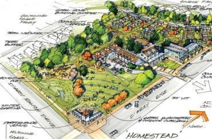
A similar story appears when looking to tiny house building companies. Tiny homes are often based on problematic off-the-grid frontier ideals, as the names of tiny house construction companies such as “Frontier Fortress” reveal (Anson, 2014, p. 299). Similarly, the company Wind River Tiny Homes (WRTH) presents a troubling reliance on colonial nostalgia to market the tiny houses they build and sell. Opening their website, one is greeted with a picture of a quaint craftsman style cottage set against a lush green background. A portion of the tagline superimposed across this image reads “bringing The American Dream back to reality by pioneering tiny homes” (Wind River Tiny Homes, n.d.). Further, one of the self-described “rustic” housing models that customers can choose is named “The Mayflower,” invoking colonial nostalgia by bringing customers back to the year 1620 when the English ship, the Mayflower, reached North America laden with passengers set to colonize the “New World” (Wind River Tiny Homes, n.d.). Thus, when marketing their tiny homes, WRTH uses frontier aesthetics and language that invokes North American colonial history to sell their product. Consequently, the marketing of tiny homes prioritizes white settler histories and recreates them through language and setting in a modern context.
Landmarks: The Journal of Undergraduate Geography // Silden
Those looking to live in villages such as “The Homestead” or in a tiny home built by WRTH are part of an upwardly mobile white class looking to move out of urban centres to a supposed quiet wilderness (Anson, 2014). The imagined landscape of the tiny house and their villages as a contemporary frontier based in colonial nostalgia furthers settler colonialism, as these citizens move out of cities to their rustic tiny cabins and stake “claim” to North American land through settlement. For example, the Sanctuary Minnesota, an 80-acre tiny house village bordering the Mille Lacs State Wildlife Management Area, is presented as an escape from urbanity; its owners hope to provide “a simpler way of life” for all residents (The Sanctuary Minnesota, n.d.). The project is ongoing, currently consisting of four tiny house cabins which are promoted by their owners as rustic and simple homes set into the “natural” landscape (Figure 4). The Sanctuary Minnesota illustrates Blomley’s (2002) argument that imagined landscapes are powerful as they influence a landscape’s built forms; depictions of tiny house landscapes as frontier settlements in art and marketing have visibly influenced the Sanctuary. As a vast private property owned by two white citizens, the Sanctuary Minnesota effectively recreates a frontier lifestyle while reinstating settler colonial “rights” to Indigenous land through white, non-Indigenous settlement.

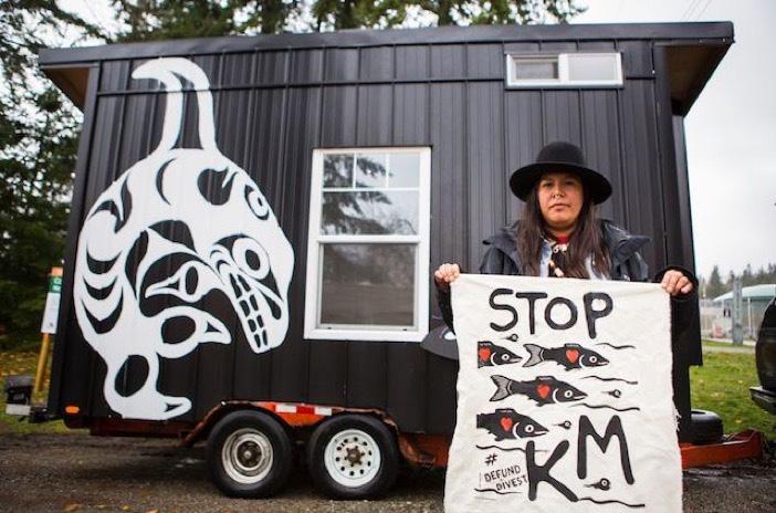
While tiny houses are imagined and used by non-Indigenous urbanites to recreate an idealized frontier way of life on Indigenous land, tiny houses are also used as tools for Indigenous resistance and decolonization as they facilitate Indigenous visibility on this same land—thus deconstructing the terra nullius discourse that justifies settler colonialism. The Anishnaabe of Grassy Narrows in Northern Kenora, Ontario have been fighting the logging industries’ encroachment into their traditional territory since 2002 (Da Silva, 2010). A key aspect of this resistance has been a highway blockade that has prevented logging actors from accessing Grassy Narrows land. Critically, the blockade contains a tiny home cabin constructed by the community’s youth. Leader and organizer Judy Da Silva (2010) describes this action as key to “decolonize our youth and get them back on the land so we’re more visible on the land” (p. 75). Thus, this tiny home’s construction countered historic justifications of colonization such as the terra nullius discourse by emphasizing the Grassy Narrows community’s presence on this land.
As a tool for reinstating Indigenous presence on Indigenous land, tiny houses have been adopted by multiple Indigenous organizations. For example, Standing Rock water protectors constructed a tiny house to block the construction of the Dakota Access Pipeline on Standing Rock Sioux territory (Cantieri, 2018). Standing Rock resistance inspired the Tiny House Warriors, a project created to block the Kinder Morgan pipeline on unceded Secwepemc territory in British Columbia (Cantieri, 2018). Founded by Kanahus Manuel of the Secwepemc and Ktunaxa Nations, the Tiny House Warriors’ resistance is a project that uses tiny homes as tools for decolonization (Figure 5). While settler
Figure 5 Kanahus Manuel of the Secwpemc Nation in front of one of the tiny houses set to block the path of Kinder Morgan’s proposed Trans Mountain pipeline expansion project, by Katie Lin, 2017, https://www.colorlines.com/articles/can-tiny-houses-halt-expansion-trans-mountain-pipeline.colonialism works to dispossess Indigenous communities from their land, decolonization focuses on reinstating Indigenous land sovereignty (LaFevre, 2015). Indigenous worldviews position human to land and animal relationships as mutually beneficial, wherein all land beings must support one another to maintain the earth’s balance (Watts, 2013). Thus, Indigenous land sovereignty is critical to decolonization as it facilitates the reinstatement of Indigenous ways of life that are deeply tied to Indigenous land relations. The Tiny House Warriors project reinstates Indigenous land sovereignty by physically establishing Indigenous presence on Indigenous land and reinstating Indigenous ways of life that settler colonialism has attempted to destroy.
Figure 6 Mayuk Manuel and her partner Isha Jules standing next to a tiny house they helped build, by Stephanie Cram, 2017, https://www.cbc.ca/radio/unreserved/rethinking-housing-from-an-indigenous-perspective-14372047/ tiny-house-warriors-build-homes-to-protest-pipeline-plans-1.4375245.
The Tiny House Warriors project is both a blockade and a site of decolonization as the project has come to represent a reinstatement of Indigenous life. Connection to community and land is critical for resistance to settler colonialism and tiny houses are increasingly imagined as part of the landscape of resistance by Indigenous land and water defenders. This is represented in the song “The Warriors” by Indigenous hip hop group Snotty Nose Rez Kids, wherein they equate Indigenous land sovereignty to the Tiny House Warriors’ resistance by stating, “Look, I stand with the warriors / This land is who we are, we can’t let you destroy us” (Snotty Nose Rez Kids, 2018, 2:20). Thus, tiny homes appear within narratives around Indigenous resistance as they are imagined as a means for reinstating Indigeneity itself. Further, while the Tiny House Warriors’ project blocks the Kinder Morgan Pipeline, these tiny homes also showcase Indigenous values and culture through their adorning murals (Cantieri, 2018). The Tiny House Warriors’ homes are built in a cube shape to better showcase art on their outside walls, celebrating Indigenous artistic styles and highlighting critical human-land relations. These murals
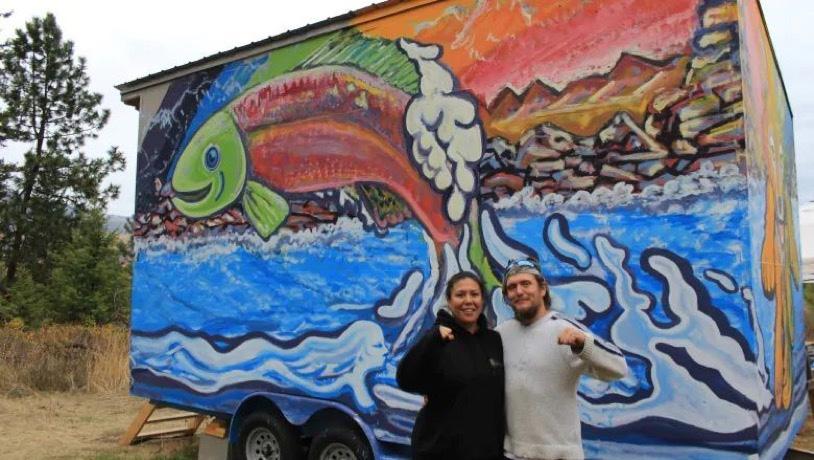 Landmarks: The Journal of Undergraduate Geography // Silden
display images of native wildlife that would be critically affected by potential Kinder Morgan oil spills (Figure 6). The Tiny House Warriors use tiny houses as tools for decolonization, connecting the Secwepemc and Ktunaxa Nations with their land and providing a space for showcasing Indigenous culture and knowledge through art. When imagined as tools for resistance, tiny homes are effectively transformed into these tools, countering other imagined tiny house landscapes that perpetuate settler colonialism.
While tiny houses are suited to various political uses, I have focused on how tiny house landscapes are viewed as recreations of an idealized frontier life and as tools for decolonization. I have argued that romanticized colonial tiny house depictions in art and marketing present a narrative that shapes tiny homes into tools for settler colonialism. These tiny house depictions prioritize colonial histories and reinforce the terra nullius discourse and reenact colonial settlement in the contemporary period. However, tiny houses are also used as tools for decolonization, as Indigenous land and water defenders use them to block colonial state projects that threaten their right to self-determination and sovereignty over their land. Tiny houses also showcase Indigenous ways of life through art and culture. Therefore, tiny house development as a form of resistance by Indigenous land and water defenders stands in direct conflict to settlers’ framing of tiny homes as a mode for recreating frontier life and reinforcing settler colonialism. Yet in both cases, it is human perception of how a tiny house landscape will manifest that ultimately shapes its material form, illustrating how powerful imagined landscapes can be.
Anson, A. (2014). “The world is my backyard”: Romanticization, Thoreauvian rhetoric, and constructive confrontation in the tiny house movement. In W. G. Holt (Ed.), Sustainable to resilient cities: Global concerns and urban efforts (pp. 289-313). Emerald Publishing.
Blomley, N. K. (2002). Mud for the land. Public Culture, 14(3), 557-582. https://www.muse.jhu.edu/article/26291
Cram, S. (2017). Mayuk Manuel and her partner Isha Jules standing next to a tiny house they helped build [Photograph]. CBC Radio. https://www.cbc.ca/radio/unreserved/rethinking-housing-from-an-indigenous-perspective-14372047/tiny-house-warriors-build-homes-to-protest-pipeline-plans-1.4375245
Da Silva, J. (2010). Grassy Narrows: Advocate for mother earth and its inhabitants. In L. Davis (Ed.), Alliances: Re/envisioning Indigenous-non-Indigenous relationships (pp. 69-76). University of Toronto Press.
Ford, J., & Gomez-Lanier, L. (2017). Are tiny homes here to stay? A review of literature on the tiny house movement. Family and Consumer Sciences Research Journal, 45(4), 394-405. https://doi.org/10.1111/ fcsr.12205
Jackson, J. B. (1987). The popular yard. Places: A Quarterly Journal of Environmental Design, 4(3), 26-32.
Judd, L. F. (2017). Tiny Houses by the River [Painting]. Fine Art America. Retrieved from https://fineartamerica.com/featured/tiny-houses-by-the-river-lisa-frances-judd.html
Kitsch, K. (2018). Tiny House Village [Illustration]. Retrieved from https://kellkitsch.com/tiny-house LaFevre, T. (2015). Settler colonialism. In J. L. Jackson (ed.), Oxford Bibliographies in Anthropology. https:// doi.org/10.1093/obo/9780199766567-0125
Lin, K. (2017). Kanahus Manuel of the Secwpemc Nation in front of one of the tiny houses set to block the path of Kinder Morgan’s proposed Trans Mountain pipeline expansion project. [Photograph]. Colorlines. https://www.colorlines.com/articles/can-tiny-houses-halt-expansion-trans-mountain-pipeline
Paperson, L. (2014). A ghetto land pedagogy: An antidote for settler environmentalism. Environmental Education Research, 20(1), 115-130. https://doi.org/10.1080/13504622.2013.865115
Rigg, N., George, D., Hochman, J., Edwards, T., McCarthy, G., & Bolosh, J. (Executive Producers). (2014-2019). Tiny House Nation. Loud TV.
The Sanctuary Minnesota. (n.d.). About. The Sanctuary Minnesota. Retrieved from https://www.thesanctuaryminnesota.com/about
Snotty Nose Rez Kids. (2018). The warriors [Song]. On Tiny House Warriors [Album]. RPM Records.
The tiny homes would have been part of a larger development called the Homestead Project. (2019, August 21). CBC News. https://www.cbc.ca/news/canada/calgary/okotoks-tiny-homes-ecovillage-council-1.5254464
Watts, V. (2013). Indigenous place-thought and agency amongst humans and non humans (First Woman and Sky Woman go on a European world tour!). Decolonization: Indigeneity, Education & Society, 2(1), 2034. https://jps.library.utoronto.ca/index.php/des/article/view/19145
Wind River Tiny Homes. (n.d.). Home. Wind River Tiny Homes. Retrieved from https://www.windrivertinyhomes.com
Landmarks: The Journal of Undergraduate Geography // Silden 65