Industry experts discuss the past decade and what’s next The geospatial sector unpacked in six questions
Spatial is no longer special
Mapping the future: industry survey insights Geo-matching turns 10: Spotlight on industry innovators
Director Strategy & Business Development
Durk Haarsma
Financial Director Meine van der Bijl
Technical Editor Huibert-Jan Lekkerkerk
Head of Content Peter Tapken
Contributing Editor Wim van Wegen
Copy-editor Lynn Radford, Englishproof.nl
Marketing Advisor Myrthe van der Schuit
Design ZeeDesign, Witmarsum, www.zeedesign.nl
Mapping the future: industry survey insights
In an era marked by rapid technological advancement, both the geospatial and hydrographic sectors are experiencing significant transformation. Recent industry surveys conducted by the esteemed international magazines and media brands GIM International and Hydro International provide a snapshot of these changes, revealing emerging trends, key challenges and future directions. These insights are valuable for professionals navigating these dynamic fields, and platforms such as Geomatching are playing a supporting role in accelerating the adoption of new technologies by connecting buyers with suppliers of geospatial software and equipment.
Spatial is no longer special 10 years of ‘GInnovation’
This year Geo-matching celebrates its 10-year anniversary. A good moment to consider what sort of innovations we have seen over the past decade. Some are probably obvious and have been hyped, others are somewhat more obscure but often just as important. Reflecting on the past decade, Huibert-Jan Lekkerkerk observes that one of the most significant developments has been the integration of geospatial information into our daily lives. Curious about when your loved ones will return from their holiday? Check airline or train tracking websites, or ask them to enable location sharing so you can see their real-time whereabouts. Need to get somewhere? Simply choose a navigation app and follow its precise directions, down to the metre.
Industry experts discuss the past decade and what’s next In celebration of Geo-matching’s 10 anniversary, we have invited four prominent geospatial experts to shed their light on the most impactful technological advancements over the past decade. This roundtable focuses on the evolution of the industry, particularly in the areas of uncrewed platforms, data processing, and the future trends. Their insights give us a clearer understanding of how these advancements have driven the industry forward and are poised to reshape the geospatial landscape.
Cover story
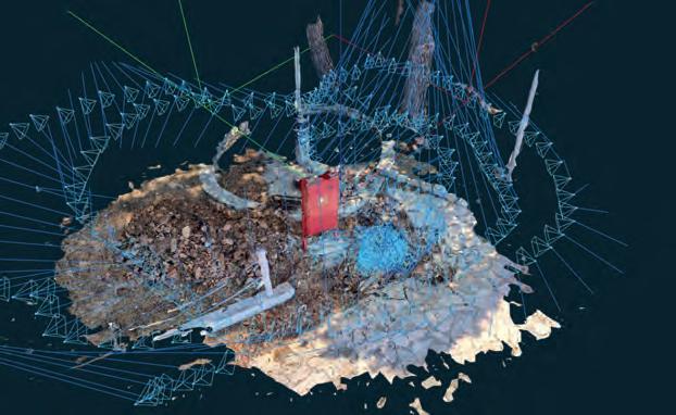
Geo-matching is proudly marking its 10th anniversary – a milestone that calls for recognition! Since its inception in 2014, the platform has been dedicated to simplifying the lives of industry professionals across the globe. What began with 600 products across 14 categories has now grown into a comprehensive resource featuring over 5,000 products from 1,200 manufacturers, alongside 1,500 case studies and 2,100 product videos. Geo-matching has become an essential tool for the geospatial community worldwide, as beautifully illustrated by the image on the front cover. (Image: Shutterstock)
Facilitating 10 years of geospatial innovation!
Wow, Geo-matching has already reached its 10-year milestone – and what a journey it has been! Geo-matching was originally created in 2014 to provide easy access to the highly valued product surveys published in our magazines GIM International and Hydro International. They provided an at-a-glance overview of the main differences between products from different manufacturers. But with the online platform, we made life even easier for industry professionals. Having started in 2014 with 600 products in 14 product categories, Geo-matching now includes more than 5,000 products from 1,200 manufacturers, 1,500 case studies and 2,100 product videos.
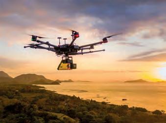
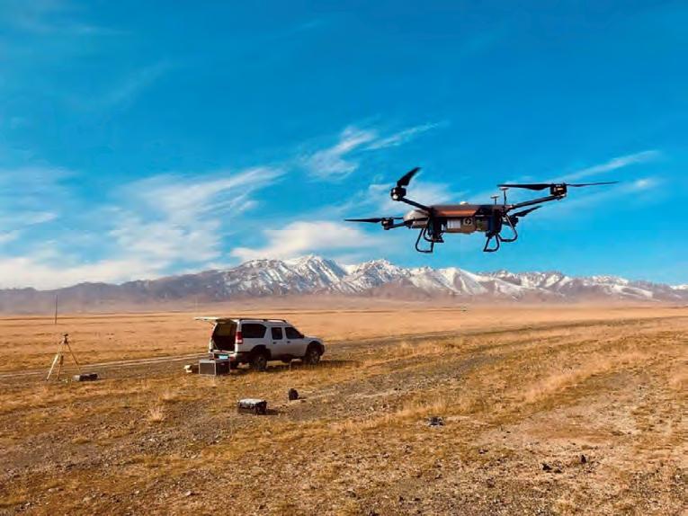
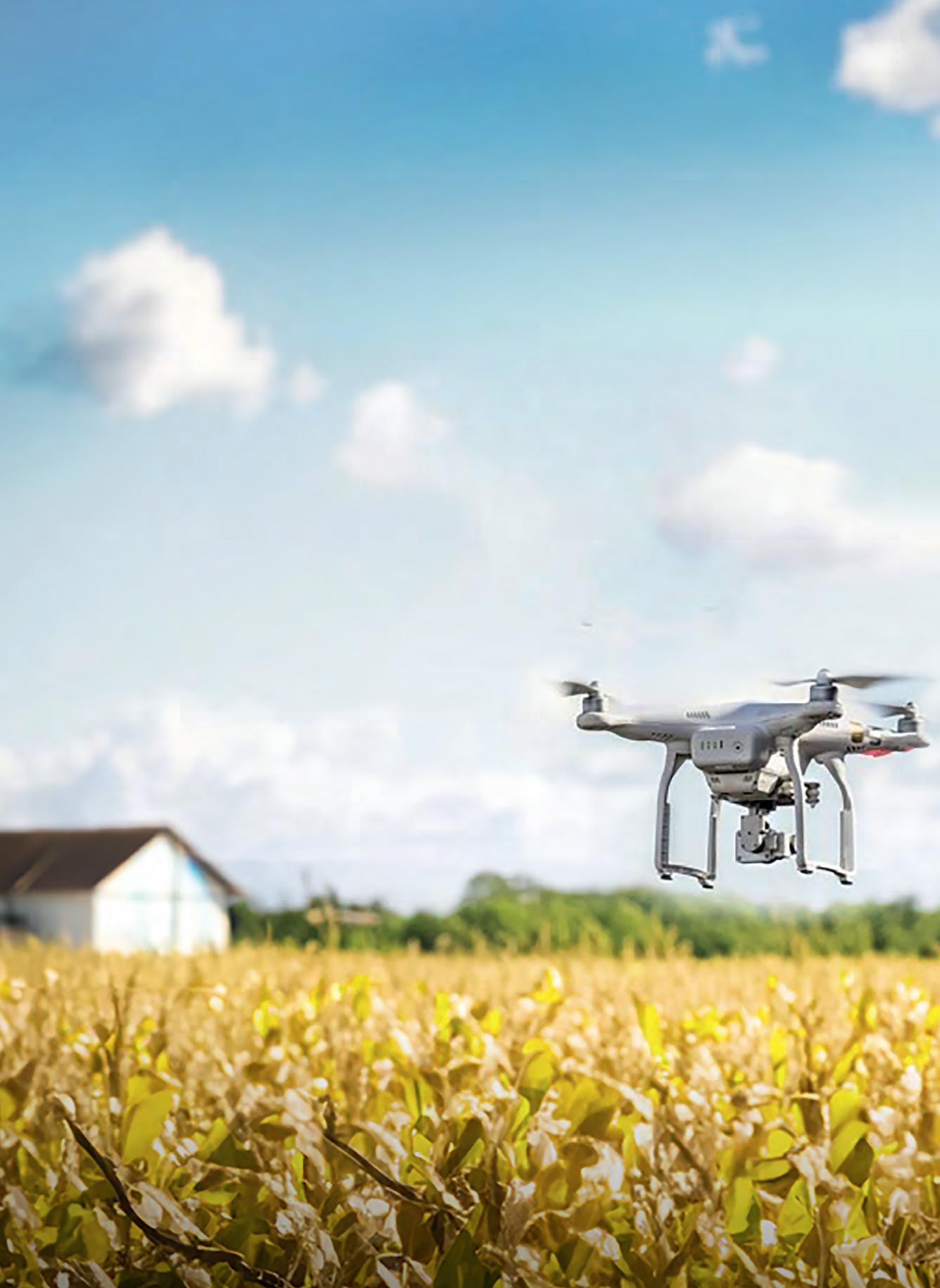
When I personally attended Intergeo for the first time in 2014, uncrewed aerial vehicles (UAVs or ‘drones’) were regarded as the most important technological development at that time. This trend was also clearly visible on Geomatching; we could see that UAV technology was frequently being researched for a wide range of applications. Even at a very early stage of the technology’s evolution, questions came in almost daily about how UAVs could be used – not only for traditional survey tasks, but also for precision agriculture, archaeology, and stockpile measurement in mining.
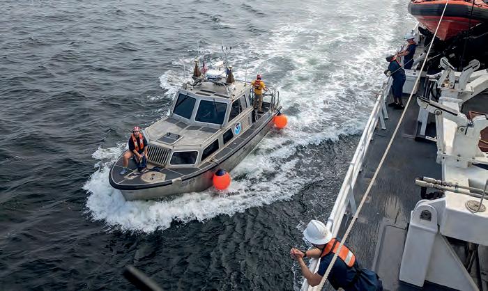
In the hydrographic sector, there has been a similar advancement of uncrewed platforms such as autonomous underwater vehicles (AUVs), remotely operated vehicles (ROVs) and uncrewed surface vehicles (USVs). These days, professionals can choose between numerous platform types and models, and a wide array of hydrographic and oceanographic platform-mountable sensors. A USV platform can be equipped with multibeam sensors for bathymetry, but it can also perform habitat mapping and take water samples, for example.
At this year’s Intergeo, visitors will see a strong increase in small Lidar scanners that can be mounted on a drone, and handheld Lidar scanners that can be used for data capture within buildings. On the Geo-matching website, we see that Lidar technology is being researched for traditional survey and mapping applications, but we’re also regularly receiving many new, interesting and sometimes surprising questions about how this technology can be used, such as for forestry mapping in Canada or for urban mapping in Dubai (with a Lidar scanner mounted on a bike!).
In this special Geo-matching anniversary publication, we have asked our various industry professionals – including our technical editor Huibert-Jan Lekkerkerk, other thought leaders and product manufacturers –to share their visions of the future trends and product developments.
In this high-tech and fast-moving environment, the role of the Geo-matching website will remain unchanged. We will keep working on an easy-to-access overview of survey and mapping products and continue to highlight interesting use cases and videos. After all, technology only gains its true value and meaning when it is applied in practice to solve society’s problems and improve people’s lives. We would like to thank all product manufacturers, system integrators and industry professionals for using the Geo-matching platform over the past 10 years. We are looking forward to supporting the geospatial and hydrographic community for another great decade and beyond!
Peter Tapken head of content, Geo-matching
Exploring emerging trends and innovations in the geospatial and hydrographic sectors
Mapping the future: industry survey insights
In an era marked by rapid technological advancement, both the geospatial and hydrographic sectors are experiencing significant transformation. Recent industry surveys conducted by the esteemed international magazines and media brands GIM International and Hydro International provide a snapshot of these changes, revealing emerging trends, key challenges and future directions. These insights are valuable for professionals navigating these dynamic fields, and platforms such as Geo-matching are playing a supporting role in accelerating the adoption of new technologies by connecting buyers with suppliers of geospatial software and equipment.
Geospatial sector: the technological shift
The most recent edition of the GIM International industry survey, which focused on land surveyors and geospatial professionals, highlights a profound shift towards more advanced and accessible technologies. Remote sensing, especially the integration of UAVs (drones) with Lidar, has become a game-changer in the industry.
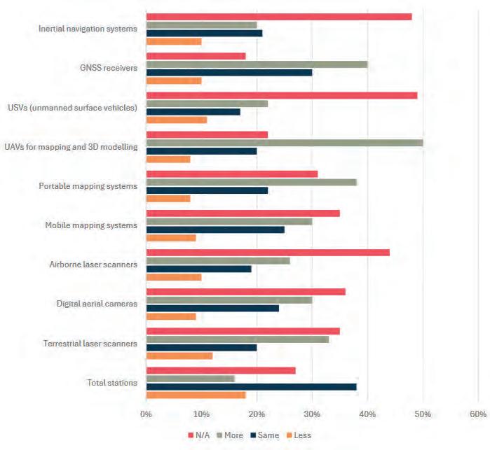
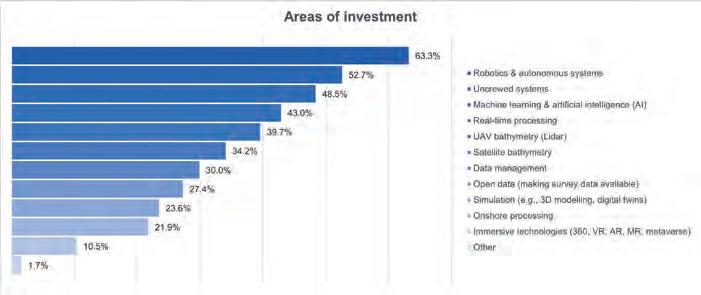
Top priorities for investment, according to this year’s industry survey conducted by GIM International among geospatial professionals, are a valuable indicator of perceived growth and development opportunities.
While airborne Lidar mapping was once considered niche and expensive, this combination is now integral to many surveying operations due to its ability to provide efficient and precise data collection. This is particularly important in challenging environments where traditional methods fall short.
Another key development frequently mentioned by survey participants is the integration of cloud computing and big data analytics, and how this is enabling real-time data processing and more sophisticated analysis, which is essential for large-scale projects. These advancements are not only improving the efficiency of data collection but also expanding the possibilities for what can be achieved with geospatial data. The GIM International survey underscores the need for professionals to adapt to these new tools, as the ability to handle large datasets and leverage cloud-based platforms becomes increasingly critical.
Geo-matching as a product comparison platform has a central place in this technological shift, as it enables professionals to compare specifications and choose the best equipment for their needs. Whether they are looking for the latest in drone technology, Lidar systems or other surveying tools, Geo-matching is a helpful tool when it comes to streamlining the decision-making process, ensuring that surveyors can adopt the most effective solutions to meet their project requirements.
Artificial intelligence (AI) is another major trend identified in the survey – as in many parts of our everyday lives. While AI promises to enhance efficiency by automating tasks such as image recognition and pattern detection, its integration is being approached with caution. Survey respondents are optimistic about AI’s potential, but emphasize that
hydrographic sector over the coming years. (Source: Hydro International)
and this is reflected in respondents’ plans to purchase new equ Denisot)
and methods are introduced. The GIM International survey highlights concerns about ensuring that data from different sources and technologies can be seamlessly integrated. This is certainly an issue of importance, as the ability to combine and analyse data from various platforms is essential for making informed decisions in complex projects.
As the use of AI and big data continues to grow, there are emerging concerns about the ethical and privacy implications of geospatial data collection and use. These concerns highlight the need for clear guidelines, and for sharing best practices to ensure that the benefits of new technologies are realized without compromising ethical standards or individual privacy.
Hydrographic sector: strong focus on autonomy
The latest Hydro International industry survey reflects similar trends in the hydrographic sector, with an undeniably strong emphasis on autonomous systems such as autonomous surface vehicles (ASVs) and unmanned underwater vehicles (UUVs). These technologies are revolutionizing data collection in the marine environment, allowing for more efficient and safer operations in areas that are difficult to access or hazardous. The advent of multibeam echosounders and subsea Lidar systems is further expanding the possibilities in underwater mapping, making it possible to gather high-resolution data in challenging environments.
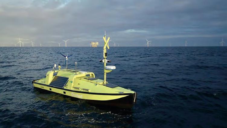
The Hugin USV is anchored at Ørsted’s Anholt wind farm, ready to be deployed for offshore metocean measurement campaigns in the wind farm industry. This stands as a good example of the ever-increasing role of autonomous survey methods in hydrography. (Image courtesy: Ørsted)
it should complement rather than replace human expertise. They also feel that we should not overhype AI, as we risk using it as a buzzword rather than zooming in on how it can really add value for practical mapping and surveying tasks. This balanced view is critical as the industry seeks to leverage AI without compromising the quality and reliability of geospatial data.
The rapid adoption of these technologies brings its own set of challenges. Data standardization and interoperability are becoming increasingly important as new tools
Survey respondents note that integration of these autonomous systems also has its challenges, particularly in terms of data interoperability and the need for standardized protocols. This is where platforms such as Geo-matching can be of great benefit. Geo-matching empowers hydrographic professionals by offering in-depth comparisons of various systems and solutions, enabling them to choose the most appropriate technology for their needs. This ensures that their operations are not only optimized for efficiency but also adhere to the highest industry standards.
Another significant trend in the hydrographic sector entails the growing capability for real-time data transmission
The
The evolution in hydrographic surveying methods necessitates acquiring new skills for the future, yet envisioning a hydrographic sector devoid of crews and offshore surveyors is deemed unlikely. (Image courtesy: NOAA)
during surveys. This development is particularly important for operations in remote or hazardous environments, where the ability to transmit data in real time can significantly enhance safety and efficiency. Again, Geo-matching can assist professionals in identifying the technologies that best meet their operational needs.
Environmental considerations are also increasingly important in the hydrographic sector. The survey highlights a growing awareness of the need for sustainable practices, which is driving innovation in energy-efficient vehicles and eco-friendly survey methods. As the industry continues to evolve, platforms such as Geo-matching can help professionals to stay informed about the latest sustainable technologies and practices. Furthermore, the increasing importance of marine spatial planning (MSP) in managing the sustainable use of marine resources is another area where Geo-matching can provide valuable insights and tools.
Workforce challenges and future prospects
Both surveys reveal a common concern: the shortage of skilled professionals in the geospatial and hydrographic sectors. The rapid pace of technological change requires a workforce that is not only skilled but also adaptable. However, attracting and retaining talent is proving difficult, especially in specialized areas such as underwater surveying and
advanced geospatial analytics. The GIM International and Hydro International surveys emphasize the need for targeted education and training programmes to address this gap.
Moreover, the importance of continuous learning and professional development cannot be overstated. As new technologies emerge, professionals must be able to quickly learn – and adapt! – to these changes. Platforms such as the three mentioned in this article can support this transition by not only providing access to the latest equipment and software but also offering educational resources such as webinars, tutorials and case studies. This helps to ensure that professionals are equipped with the knowledge and skills they need to succeed in an evolving landscape.
The outcomes of the most recent Hydro International industry survey also suggest that public-private partnerships could be key to addressing the skills shortage. By collaborating with educational institutions, governments and private companies, the industry can develop strategic workforce plans that include comprehensive training and education initiatives. These partnerships could play a crucial role in ensuring that the workforce meets future demands.
Despite these challenges, the future holds great promise. Many survey respondents believe that the ongoing digital transformation will unlock exciting new opportunities for growth. However, this will necessitate a strategic focus on workforce development, including specialized education and training programmes. When it comes to equipping professionals with the tools they need, Geo-matching stands out as the ideal platform to support this evolution.
Crossroads
The geospatial and hydrographic sectors are at a crossroads, with rapid technological advances such as AI and drones driving growth. However, the industries face challenges, including skill shortages and economic uncertainties. Geo-matching plays a crucial role in helping survey professionals to navigate these complexities by providing access to the latest innovations and tools. In this way, professionals can stay ahead of the curve, enhance their expertise, and contribute to building a more resilient and sustainable future in these evolving fields.
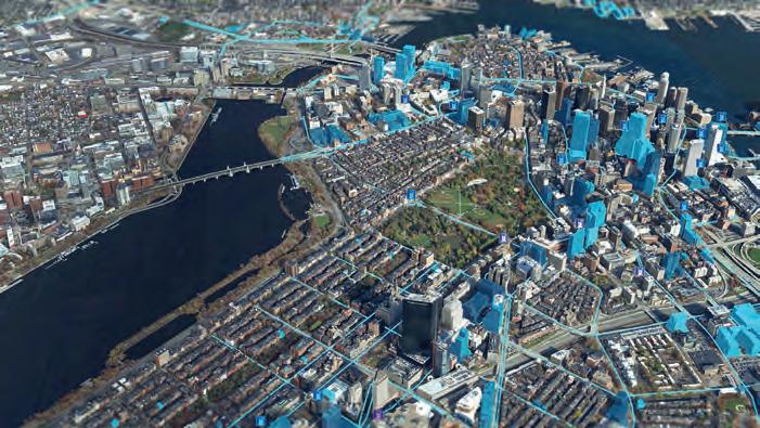
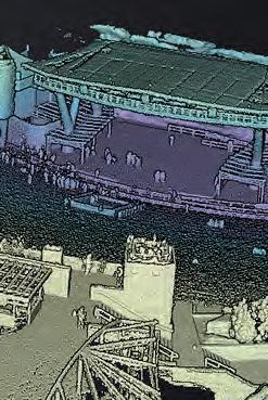
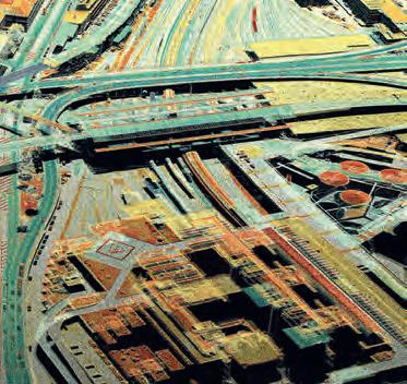
rising need for freshly acquired geospatial data is unlocking substantial opportunities in the sector. This example features a reality mapping 3D model of Boston, which forms the basis for digital twins of cities. (Image courtesy: Bluesky and Esri)
10 years of ‘GInnovation’
Spatial is no longer special
By Huibert-Jan Lekkerkerk
This year Geo-matching celebrates its 10-year anniversary. A good moment to consider what sort of innovations we have seen over the past decade. Some are probably obvious and have been hyped, others are somewhat more obscure but often just as important.
One innovation is of course the use of artificial intelligence (AI). So, why not start by asking ChatGPT 3.5 how the geospatial industry has changed in the last 10 years? ChatGPT comes up with the usual suspects in its top three (technology advancements, data explosion, cloud computing & GIS). Some others are: enhanced visualization, new applications, and regulatory and policy changes. Each of these will be investigated below. The closing paragraph is however very interesting as ChatGPT feels that “overall, the geospatial industry has become more dynamic, integrated, and essential across various domains, driven by technological innovations and a growing recognition of the value of geospatial data in solving complex problems and improving decision-making”. In other words, spatial is no longer special, but part of mainstream processes!
Technological advancements
Probably the biggest change has been the introduction of uncrewed aerial vehicles (UAVs or ‘drones’). Whereas 10 years ago the industry was fully experimenting with this technology, nowadays literally anybody can do photogrammetry with a cheap drone and off-the-shelf (open-source) software. This has probably democratized geospatial information collection as no other technology ever has. GPS was a step to democratizing positioning, but was hardly used by the public for data collection. Now, everybody can create a 3D model of whatever they want.
In a similar way, Lidar has become much more integrated in daily workflows as sensors have become less expensive and even small enough to fit under a (larger) drone. At the same time, small, handheld Lidar has become available, allowing data capture within buildings. As a result, Lidar is now used on a regular basis in all sorts of domains, from construction to archaeology and farming.
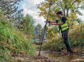
In the same decade, other technologies have become more mature, and accuracies and resolutions have increased across the board. More evolution than revolution. A good example is GNSS which became cheaper and ever-more accurate. Whereas GNSS precise point positioning (PPP) had limited use 10 years ago, it is now the standard in offshore hydrographic surveying and on land where no RTK coverage is available. Additions like tilt correction make using a GNSS receiver even easier.
Figure 1: A CHC Navigation BB4 UAV which can be equipped with Lidar and cameras.
Challenges still not (fully) solved are universal indoor positioning and also reliable detection of unexploded ordnance (UXO), both on land and in marine environments. In hydrography, satellite-derived bathymetry and bathymetric photogrammetry are slowly being developed. However, both are still in the research stages with a Technological Readiness Level of 7.
Data advancements
Over the past decade, the concept of big data has become more i mportant. This is coupled with the progress of processing advancements such as de ep learning and machine learning (see below). Not just specialist sensors that produce more data, but more data in general has become available based on a geographic component. Insurance companies, tech giants but also web shops now regularly use geo graphic information such as postal codes and addresses for specific analysis for cre ating customer profiles and targeted approaches.
Another derivate of data advancements is the development of the digital twin. Although again the basic concept is not new, the specific definition of the digital twin concept has spurred an increase in collecting – and, more specifically, connecting – geospatial information with a single purpose in mind.
At the same time, a move towards 3D data can be seen where existing datasets are upgraded to a 3D approach. An interesting use case is the generation of a 3D base map from the existing 2D base map and height data from various sources including Lidar and photogrammetry.
Whereas 10 years ago there were many discussions about open data, we now see many datasets being provided in an accessible way, with app makers reusing the data to create specific applications. At the same time, we have seen an increase in regulations about sharing data, most specifically around data privacy and security. As seen, this coincides with the collection of more personal data and the ease with which our movements can be tracked by modern devices. Big tech companies find themselves facing government lawsuits for abusing such (geo)data.
Processing advancements
Probably the most significant change in the last decade is the (fast) rise of AI across domains. Though technologies such as machine learning (ML) are not new and were used in the analysis of, for example, satellite imagery at the start of the decade, now everything seems to be geared towards AI. While it is a hype, it is also a technology that is seeing rapid implementation. Using AI/ML allows software to become more autonomous and aid the geospatial information specialist with tools such as object detection and recognition, and automatic de-spiking of data, allowing complex analysis and data classification.
On a different level we see simpler data processing becoming more democratized. An example is the generation of 3D imagery from photogrammetry (or 3D scanners). Where this used to be a complicated process, even requiring specific instruments until the turn of the century, it is now literally a matter of a few mouse clicks between photographs and a 3D model or orthophoto. The use of layered geoinformation is now also standard in many web viewers.
Figure 2: A Spectra Precision SP100 GNSS receiver with PPP and tilt correction.
Figure 3: Topcon Magnet software for processing and modelling point clouds.
Towards the next 10 years
Two technologies that showed much promise 10 years ago and were predicted to have (fully) happened by now are still under development. One is aut onomous (driving). While developments seemed to be moving rapidly, the actual implementa tion seems to be more diffi cult than promised. A case in point are autonomous cars. A decade ago, it was envisaged that we would be driving fully autonomously by now. W hile the technology
Though technologies such as machine learning are not new and were used in the analysis of, for example, satellite imagery at the start of the decade, now everything seems to be geared towards AI
has advanced without any doubt, we are not at the point of full y autonomous just yet. However, this might happen in the next 10 years, provided we ca n solve legal issues (who is to blame in case of an accident?), geospatial issues (a ccuracy of positioning, cartographic material and fast updates) as well as technologica l issues such as object detection under diffi cult circumstances.
Another technology that was envisioned to have changed our live s by now is augmented reality. Although still very much alive, the technology is now limited to specifi c use cases (and even for those is very expensive). Virtual reality is now somewhat of a standard for certain types of games, and equipment is becoming less expensiv e and more elaborate every year.
Conclusion
When looking back at all the changes described above, maybe the biggest change was not yet mentioned. That is the invasion of geospatial information into daily lives. Want to know when your loved ones will arrive back from their holiday? Look at airline or train tracking websites, or alternatively ask them to put on their location tracking and see where they are in real time.
Need to go somewhere? Pick any navigation app, and go there to the metre…
But it is not just daily life. Agriculture and construction have always been technologyheavy, but nowadays any farmer can just get a drone, launch it and have an instant idea of the crop status. Want to track your cattle? It’s possible (albeit still a bit expensive). But it’s not just these domains; as stated, insurance firms and web shops are also using it to analyse their customer behaviour. And archaeologists leverage all sorts of remote sensing and geoinformation (GI) technology to investigate possible cultural heritage sites.
The general public is also much more aware of these endeavours thanks to TV programmes such as National Geographic’s ‘Drain the Oceans’, or news items about finding Amelia Earhart’s plane, HMS Terror and Mayan temples. And then, on a less positive note, there is the disruption of positioning systems such as GNSS and INS during the conflict between Russia and Ukraine. The resulting media coverage makes more and more people aware of the use and limitations.
The geospatial industry is indeed going strong, and is set to remain strong for (at least) the next 10 years.
About the author
Huibert-Jan Lekkerkerk is a contributing editor to GIM International and Hydro International, a freelance hydrographic consultant, the author of publications on GNSS and hydrography, and a principal lecturer in hydrography at Skilltrade (Cat B) and the MIWB (Cat A) in the Netherlands. He is also chair of the Hydrographic Society Benelux and the IFHS HPAS panel.
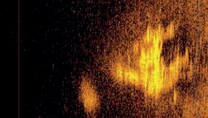
Figure 4: A sonar image captured in the Pacific Ocean by Deep Sea Vision is believed to depict Amelia Earhart’s Lockheed 10-E Electra aircraft. (Image courtesy: Deep Sea Vision)
3Dsurvey
To celebrate Geo-matching’s 10-year milestone, we are highlighting some of the companies showcasing their products on our online comparison platform. How do they set themselves apart in the market? And which key features should buyers consider when making purchasing decisions? Here, 3Dsurvey shares insights into its recent advancements and improvements, as well as its strategies for staying ahead of industry changes.
How do your products differentiate themselves from other solutions on the market?
I am convinced that the product greatly defines the creative team and their values. From the very beginning, we have been enthusiastic, flexible, and willing to cooperate and help, especially in solving complex problems. We have always aimed to make it as easy as possible for 3Dsurvey users to achieve final results and save time in their work. We closely collaborate with users and partners who represent us in the market, as local requirements on the global market vary greatly.
We offer free training to every new user on how to use the software and I believe that, compared to the competition, 3Dsurvey is easy to use. In addition to numerous unique features, we also provide fast, responsive, high-quality support and regular updates. We strive to keep up with developments because it is important to follow other industries that impact the development of photogrammetric software, such as the development of computers, cameras, drones, legislation and more. I would like to emphasize that 3Dsurvey is not only intended for mapping but also for more complex processing and merging of various point clouds captured with different tools (SLAM, Lidar, videogrammetry). Our resellers have made the biggest difference compared to competitive solutions, as they sell 3Dsurvey with every surveying instrument.
When purchasing your products, what features are the most critical to consider?
When purchasing 3Dsurvey, it is important to know that it was made by surveyors for surveyors, so it has features designed for faster working and achieving high accuracy. This is important because surveyors are precise engineers who bear great responsibility in their work. The most practical and widely used features are X-ray, volume calculation, CAD tool, point cloud merging, floating licence, and cloud sharing.
What do you anticipate for the future development of technology, and how do you plan to stay ahead of these changes?
Software development is never complete, as 3Dsurvey is like a living being. It evolves from small to large, from simple to more complex tools, and we are also expanding its usability. For a long time, our slogan was “by surveyors for surveyors”. But 3Dsurvey is now becoming more widely applicable – not just for surveyors, but also for builders, architects, archaeologists, and everyone involved in spatial and object analytics.
For most users, a 3D point cloud represents too much unorganized spatial data and is difficult to use in other software. Spatial data is most useful when it is constructed, modelled, classified and spatially defined. Our guiding principle is “keep it simple”, and we will continue to strive to maintain this approach in the future. Certainly, 3Dsurvey is currently one of the easiest software solutions to use, even though we have added a huge number of functions in recent years and many more are on the development department’s list. Our development focus will definitely be on advanced CAD functions and automatic artificial intelligence (AI) classification.
Which advancements or improvements have been made to your products in recent versions?
We have made a number of upgrades to the latest version, 3Dsurvey 3.0. For example, the coordinate systems (PROJ) solution offers users a faster path to precise georeferenced spatial data without unnecessary local transformations – which reduce accuracy – and without the need for third-party software. Thanks to automatic machine deactivation, the licence is immediately freed up for use on another device after the 3Dsurvey computer is shut down, so no more waiting or manual intervention is required. Meanwhile, our new Clip function empowers users to clip their results to the exact
3Dsurvey allows geospatial professionals to generate highly accurate georeferenced 3D models through RTK videogrammetry.
area they need. By using a CAD line – which can be imported or created directly in 3Dsurvey CAD – the data can be precisely cut so that only the relevant portions are shared with customers. Another new feature is the script engine update, which offers the added benefit of being able to process multiple datasets one after another, and/ or process one dataset multiple times with different settings. Above all, we are most proud of the fact that we are introducing modules to the 3Dsurvey solution for users to add as needed. We are starting with two modules. The Scan module offers the option to merge point clouds or meshes from sources like photogrammetry, videogrammetry, Lidar, sonar, SLAM, GNSS or total stations. It is for all cases when it is
necessary to combine data from different locations using identical points, or visualize drone Lidar data, SLAM or terrestrial scanner data with options like intensity, number of returns or scanning time. This is an ideal add-on for users struggling to produce accurate floor plans from their scan or SLAM data. The second module is RTK videogrammetry. Its standout feature is the elimination of overlap concerns, since the video is continuously shot with 30fps or more. Integrating videogrammetry into the data collection toolkit promises to accelerate project timelines, streamline workflows and, above all, make users more responsive, since a smartphone is always on site. This makes videogrammetry a cost-effective solution for surveying tasks.
studied geodesy before working for a surveying company as a geodetic engineer. After five years, in 2004, he founded his own company. Then in 2011 his passion for photogrammetry led to him developing 3Dsurvey as a startup. Today, 3Dsurvey is an international product that is sold through representatives in more than 50 countries worldwide.
Emesent
To celebrate Geo-matching’s 10-year milestone, we are highlighting some of the companies showcasing their products on our online comparison platform. How do they set themselves apart in the market? And which key features should buyers consider when making purchasing decisions? Here, Emesent shares insights into its recent advancements and improvements, as well as its strategies for staying ahead of industry changes.
How do your products differentiate themselves from other solutions on the market? Our Hovermap ST and ST-X have unrivalled versatility and accuracy, enabling users to rapidly create a 3D model of a site by using a variety of capture methods, including handheld, backpack, vehicle, drone and more. This is enabled by a modular, lightweight form factor and proprietary SLAM algorithm which is based on Australia’s Commonwealth Scientific and Industrial Research Organisation’s (CSIRO) Wildcat technology. Wildcat has unparalleled robustness in challenging environments, allowing users to create highly accurate 3D models where others cannot.
Meanwhile, our newly available Backpack RTK solution for georeferencing Hovermap scans reduces or eliminates the need for ground control points on projects while achieving centimetre-level georeferencing accuracy in ideal conditions. What makes this solution unique is that it allows users to seamlessly swap their Hovermap unit between vehicle-based scanning and backpack-based scanning, while benefiting from RTK data for both modalities. Our SLAM algorithm uses the RTK data to improve the accuracy of the point cloud, including when scanning long linear assets or areas with limited features for SLAM.
When purchasing your products, what features are the most critical to consider? Hovermap is an extremely versatile product, with many capture methods and accessories which can be explored. It is used for an incredible variety of projects, including topographic surveys, scan to BIM, tunnel surveying, bridge inspection, plantation mapping, stockpile volumes and more. Therefore, it is most important to think about which type of projects it will be used for, and how it can be tailored to meet the business needs. For example, users who require high accuracy and high-quality imagery for scan-to-BIM projects may consider the Hovermap
ST-X with 360-degree camera and the allnew Backpack RTK. Users can benefit from automatic georeferencing, and can extract 360-degree images to assist with drawing up. On the other hand, users who are interested in bridge inspections may consider the Hovermap ST-X with the DJI M350 drone and our marketleading autonomy. This combination enables high-quality image capture very close to and even directly underneath the bridge, with no risk of collisions.
What do you anticipate for the future development of technology, and how do you plan to stay ahead of these changes?
At Emesent, we are committed to consistently pioneering in the technology landscape and providing customers with solutions that meet their most challenging needs. We are at the forefront of SLAM scanner development, proving they can be a viable alternative to traditional surveying methods for certain projects, saving users significant time in the field. We expect SLAM algorithms to improve and become widely adopted, and for Lidar data to become more seamlessly integrated with third-party (or vertically integrated) software. We also expect Lidar sensors to become smaller and lighter with better accuracy, range and point density, allowing mobile laser scanners to improve.
We will stay ahead of these changes by ensuring we’re utilizing the latest and best Lidar sensors. We will continue to invest in our market-leading SLAM to achieve better and more accurate point clouds. We’re also constantly improving our autonomy capabilities, and we’ll continue to improve our visualization and processing software Aura, ensuring a seamless user experience
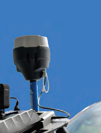
Emesent Vehicle RTK delivers confident scanning over large areas and of long, linear assets without the need for ground control points.
to help users get to their end deliverable as quickly as possible. All of this will ensure Hovermap can be used in a wider variety of environments, can capture data more efficiently, and can be deployed for even more projects.
Which advancements or improvements have been made to your products in recent versions?
Hovermap with Backpack RTK and 360 colourization allows users to combine georeferenced data with 360-degree images and colourized point clouds for comprehensive site context. Automated georeferencing allows users to reduce or eliminate ground control points on their
projects and place scans in the real world with ease. Hovermap can be seamlessly swapped from the Backpack RTK to the recently launched Vehicle RTK, allowing flexibility to project needs.
We’ve also recently launched an integration with the Freefly Astro Drone, delivering unmatched capabilities. This integration offers up to 25 minutes of flight time, even when carrying Hovermap, which opens up more opportunities for continuous, autonomous scanning capabilities over large areas. It is also able to operate in GPSdenied, confined or difficult-to-access areas, plus it is compliant with stringent regulatory environments.
the forefront of drone autonomy R&D for nearly 20 years. He led the development and commercialization of Hovermap in CSIRO, and cofounded Emesent in 2018 to bring this groundbreaking technology to market.
Exyn Technologies
To celebrate Geo-matching’s 10-year milestone, we are highlighting some of the companies showcasing their products on our online comparison platform. How do they set themselves apart in the market? And which key features should buyers consider when making purchasing decisions? Here, Exyn Technologies shares insights into its recent advancements and improvements, as well as its strategies for staying ahead of industry changes.
How do your products differentiate themselves from other solutions on the market?
The rugged modularity itself separates the Exyn Nexys from the market in its ability to be singular mapping solution for the vast majority of projects. It is a modular 3D mapping solution that can be used either handheld, backpack-mounted, vehicle-mounted, droneintegrated or ground robot-mounted. This greatly simplifies budgeting and execution for in-field teams in a way our customers love.
Its autonomous navigation is also a key differentiator in the market. Most of the market has little or no autonomous capability, and Nexys is much more robust than any who do. When paired with a drone or terrestrial robot, our solution uses proprietary autonomy algorithms to collect data without a pilot – even in GPS-denied, hazardous and unilluminated environments. Features like navigating through dust clouds or outside line of sight and radio communications, and detecting razor-thin wires and other obstacles underline the fact that not all autonomy is created equal.
When purchasing your products, what features are the most critical to consider?
Flexibility is a critical aspect when considering surveying and mapping tools. Our customers appreciate being able to purchase one device that will work for the majority of their projects moving forward rather than constantly purchasing new tools. Another aspect to consider is accuracy and speed of capture. Nexys is survey-grade accurate and speeds up the capture process by multiples as compared to terrestrial scanners. The ability to quickly capture surveygrade data in a repeatable fashion when necessary is a critical component of evaluating tools. Last but not least, cost will always be an integral part of the purchasing process and it has been important at Exyn to provide high-quality equipment at cost-effective levels.
What do you anticipate for the future development of technology, and how do you plan to stay ahead of these changes?
There has been exponential growth in the use of robotics in surveying and mapping, and that is expected to continue. Advancements in safety, ease of use and robustness will accelerate and further drive the adoption even more. The safety aspects alone of allowing a robot to access areas either inaccessible or dangerous to humans have pushed the extremely rapid advancement of autonomous navigation. Here at Exyn, our autonomous navigation for robotics is geared towards these GPSdenied and dangerous areas that are most difficult to navigate through. Focusing our efforts here makes it much easier for our team to hone our autonomy for additional environments such as manufacturing and warehousing facilities, oil and gas environments, construction sites, renewable energy sites such as wind farms and solar farms, and many more. Our goal is to continue to innovate and improve to push the limits of autonomous navigation for robotics, to elevate safety and reduce barriers to entry such as cost and ability to deploy.
Which advancements or improvements have been made to your products in recent versions?
Nexys boasts significant improvements to map accuracy and usability as well as meaningful advancements in autonomous navigation. Accuracy improvements have been achieved through hardware and software changes including a new sensor option and improvements to proprietary algorithms on the software.
Nexys captures real-time colourized point clouds for instant 3D model accuracy.
We have also focused on improving the navigation in areas like millimetre item detection, navigation in heavy dust, and even more increased reliability when out of communication and sight range. This is also capped with additions and improvements
to the user interface on our software platform such as a revamped ground control point process. These changes make autonomous mapping mission planning and execution even faster and easier for our customers.
value of Exyn’s hardware, platform modularity, and aerial and terrestrial autonomy to companies within the infrastructure sector. His specific focus is on construction, engineering and geospatial teams.
Nexys: 3D mapping for geospatial surveying.
Accelerating 10 years of geotechnology adoption together
Powered by our premium manufacturers
and many more ...
3D Target
Aanderaa
Advanced Navigation
Aeromao
Airborne Technical Systems
Airmar
Alpha GEO (a-GEO)
Alpha Surveying
AML Oceanographic
Applied Acoustics
Baywei Sonar
Blueprint Subsea
Boxfish
Bynav
CADDEN
C-Astral
CHC Navigation
Codevintec
ComNav Technology
Develogic
dotOcean
DREAMTNS (PozStar)
Echologger
EdgeTech
EIVA
Eos Positioning Systems
Epson Europe Electronics
Evologics
Exail
Eye4Software
Falmouth Scientific
FOIF
Frankstar Technology Group
Geneq (SXBlue)
GeoAcoustics Ltd
GeoDyn Technology
Geosun Navigation
GPS Networking
GreenValley International
Haiying Marine
Headwall Photonics
HxGN Content Program
Hi-Target
IGI
imajing
Impact Subsea
Inertial Labs
InfraTec GmbH
Innomar Technologie
ITER Systems
Javad GNSS
K.U.M.
Kongsberg Discovery
L3Harris ASV
L3Harris
Laser Technology
Lead'Air, Inc.
Leica Geosystems AS
Lidaretto
LiteWave Technologies
Manam Applications
Maritime Robotics
Medusa Radiometrics
METTATEC
MicroSurvey Software Inc.
Movella
Nordic Wing
NorPix, Inc
Nortek AS
Norwegian Subsea
Novatel
Ocean Physics Technology
OceanAlpha USV
OxTS
Parker Hannifin
Phase One A/S
PMS Photo Mess Systeme
Poseidon Robotics
Pyroscience GmbH
Pythagoras
QPS
Radac
RBR
ReSe Applications LLC
Rim Drive Technology
RJE Oceanbotics
RS Aqua
RTsys
Satlab
SBG Systems
Schneider Digital
Seafloor Systems
Share UAV
Sidus Solutions
SimActive
SingularXYZ
Sokkia
SOMAG AG
Sontek - Xylem
Spectra Geospatial
SPH Engineering
Stonex
Subsea Europe Services
Technogis
Teledyne Geospatial
Teledyne Valeport
Topcon Europe Positioning
TOPODRONE
Trimble Inc
Trimble Applanix
Vectornav Technologies
VideoRay
WASSP Multibeam
Water Linked
XGRIDS
YellowScan
Zoller + Fröhlich
Gexcel
To celebrate Geo-matching’s 10-year milestone, we are highlighting some of the companies showcasing their products on our online comparison platform. How do they set themselves apart in the market? And which key features should buyers consider when making purchasing decisions? Here, Gexcel shares insights into its recent advancements and improvements, as well as its strategies for staying ahead of industry changes.
How do your products differentiate themselves from other solutions on the market?
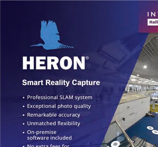
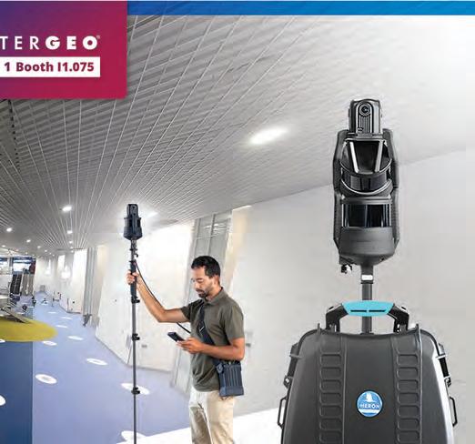
HERON stands out from other professional SLAM systems with a combination of cutting-edge features. Our proprietary algorithm ensures accurate surveys in a number of difficult situations by producing highly optimized trajectories and supporting pathways without loop closures. HERON’s trajectories can be constrained and georeferenced using ground control points or georeferenced point clouds acquired with other sensors (e.g. TLS, drone, mobile scanner), achieving local millimetric accuracy. For outdoor acquisitions, it can be equipped with a quality topographic GNSS system. HERON is provided with 120m- or 300m-range Lidar sensors and a proprietary highresolution 360° camera for comprehensive data capture, combining high-resolution point clouds with 8K resolution images.
Starting at just 3kg, the lightweight and portable design offers unparalleled flexibility. It adapts to various surveying conditions, whether mounted on poles of up to 15m for cavity mapping, used in underground environments, or deployed on vehicles and robots. Its broad array of accessories allows customization to meet specific client requirements. Our system is delivered with a complete suite of desktop software, enabling full control over data processing without the need to upload data to external servers and avoiding additional costs. Last but not least, HERON can self-localize to a BIM model or a previous survey to detect discrepancies or changes.
When purchasing your products, what features are the most critical to consider?
When choosing an indoor mapping system, the quality of the SLAM algorithm is the essential feature to consider, as it directly impacts the final data quality and dictates the processing workflow. Besides the abovementioned features, HERON’s proprietary algorithm works on desktop software offering two processing modes: a fully automatic mode with presets for specific surveying scenarios – such as small rooms, tunnels, stairs or outdoor sites – and a fully customizable mode. This one significantly enhances value by allowing users to optimize the quality of their results, making the final product a reflection of their expertise.
Another key feature is the ability to generate output results not confined to the proprietary software but instead fully compatible with other platforms. HERON’s data can be exported to widely used software like ReCap and several cloud-sharing platforms. A noteworthy aspect is the capability of the 360° camera to capture 8K images or 4K videos without burdening the data acquisition and storage process, as well as office operations. Beyond these aspects, the field functionality must also be considered. The highly versatile design prevents it from being restricted to a single configuration. The capture head can be easily mounted on rugged or ultra-light backpacks, extendable poles and vehicles. Additionally, it can be equipped with various accessories –such as LED lights for dark environments – which are particularly useful during the surveying phase.
What do you anticipate for the future development of technology, and how do you plan to stay ahead of these changes?
We are witnessing significant advancements in SLAM systems, driven by the growing importance of visual data. Artificial intelligence (AI) algorithms will increasingly utilize imagery information in combination with 3D data for object recognition and enhanced localization capabilities. Originally used only as survey instruments for topographic applications, SLAM-based systems are now expanding into geospatial and other applications, playing a crucial role in the development of digital twin models. Surveyed environments are converted into virtual spaces enriched with updated information that is immersive and remotely accessible, facilitating data exchange for planning, management, decision-making and other purposes.
We are at the forefront of this evolution, advancing both our hardware and software algorithms to enhance its capabilities. The development
HERON’s portable 3D mapping systems offer remarkable accuracy and exceptional photo quality.
includes bolstering existing features while introducing new functionalities that support emerging acquisition and processing methods. This ongoing development underscores HERON’s commitment to providing state-ofthe-art tools for professionals in diverse fields, driving innovation and efficiency in remote data access and the modelling of immersive environments.
Which advancements or improvements have been made to your products in recent versions?
We have recently made significant advancements to enhance HERON’s capabilities. One of the key developments is the introduction of a proprietary panoramic camera that stands out for its compactness and advanced capture features. This camera can operate in both single-shot mode at 8K resolution, and in streaming mode at 4K/24fps. The captured images are automatically mapped onto the point cloud,
enabling the creation of highly photorealistic 3D models. These models are ideal for developing digital twins, providing a detailed and accurate virtual representation of realworld environments.
We have also integrated a high-performance GNSS receiver, designed for advanced topographic applications. This receiver not only georeferences the 3D model but also optimizes its global and local accuracies, achieving millimetric precision. This level of accuracy is crucial for applications requiring detailed and reliable geospatial data. Furthermore, we have established new partnerships with leading cloud-sharing platforms. These collaborations enhance the system’s versatility, allowing users to seamlessly share and manage their data in real time. Through these innovations, HERON continues to provide state-of-the-art tools that meet the evolving needs of professionals in geospatial and topographic fields.
Matteo Sgrenzaroli (Eng, PhD) is cofounder of Gexcel Srl, an independent company with nearly 20 years of experience designing and selling 3D mapping and Lidar data processing systems. He serves as product manager and head of research and development.
RIEGL
To celebrate Geo-matching’s 10-year milestone, we are highlighting some of the companies showcasing their products on our online comparison platform. How do they set themselves apart in the market? And which key features should buyers consider when making purchasing decisions? Here, RIEGL shares insights into its recent advancements and improvements, as well as its strategies for staying ahead of industry changes.
How do your products differentiate themselves from other solutions on the market?
For more than 40 years, RIEGL has been introducing innovative sensors and systems to the market, establishing standards in terms of reliability, effectivity, accuracy and durability. For numerous surveying and engineering scenarios, the generation of digital twins at a wide range of scales is a fundamental demand. The complexity of specific applications requires the adaption of provided systems, and harsh environmental conditions may challenge the technical design. Due to our long-term experience and awareness of these factors, RIEGL’s portfolio safeguards successful data acquisition under various conditions with tailor-made solutions.
Whether airborne or terrestrial, static or kinematic – for each survey scenario, we are
design customized solutions for the combination of these different survey strategies and routines. For example, RIEGL’s terrestrial laser scanners are perfectly aligned with customer preferences. Their low weight, their robust onboard registration of scans, and especially RIEGL’s extremely fast workflows make them suitable for even tough daily use. The unique real-time control of the survey progress and monitoring of the collected data saves time and effort. In short, an investment that pays off.
When purchasing your products, what features are the most critical to consider?
RIEGL’s main policy includes taking care of the customers’ preferences. The basic prerequisites for this are excellent performance data, outstanding manufacturing quality, longevity, and reliability. We listen to our customers and take their concerns seriously, working with them to define an all-inclusive package that is optimized for their specific tasks and adapted to their existing framework conditions. In addition to in-depth consultations, we also include live demonstrations and test projects, and provide corresponding software packages, tools and useful apps, as well as interfaces to well-known and proven third-party software and hardware.
We also offer additional benefits to not only encourage our customers to buy our products, but also to retain their loyalty to RIEGL. After the purchase, we ensure that the customers can make optimum use of our products by providing an intensive training phase tailored to the customer’s needs, and continuing support during the lifetime of the sensor. Appropriate service cycles and upgrades are proven to ensure durability of instruments and reliability of data. Our cooperation with numerous customers, whom we have been supplying for decades, shows that we are on the right track.
What do you anticipate for the future development of technology, and how do you plan to stay ahead of these changes?
Digitalization is finding its way into all areas of life. Consequently, there is also an increasing need to acquire the corresponding basic data. The challenges ahead of us include not only the accurate and precise acquisition of data, but also the fast handling of this information. To enable the most effective analysis of the data, applicable information must be derived in a straightforward and highly automated approach.
We are constantly working on the further development of our hardware and software products to offer new, even more powerful options for both data acquisition and processing. Close contacts with users and customers, but also collaborations in high-end research, are prerequisites for precise and solution-oriented development. While in the field of data acquisition, customers can expect further advances in measurement rate, accuracy and range, as well as efficient processing routines in respective formats for further analysis. The tight integration of Lidar data and navigation data safeguards precisely georeferenced results from all types of offered kinematic and static laser scanning systems. The combination of deep learning and cutting-edge hardware will enable fast, near-to-real-time processing of Lidar data, enabling new applications and more automated data handling and information extraction from Lidar.
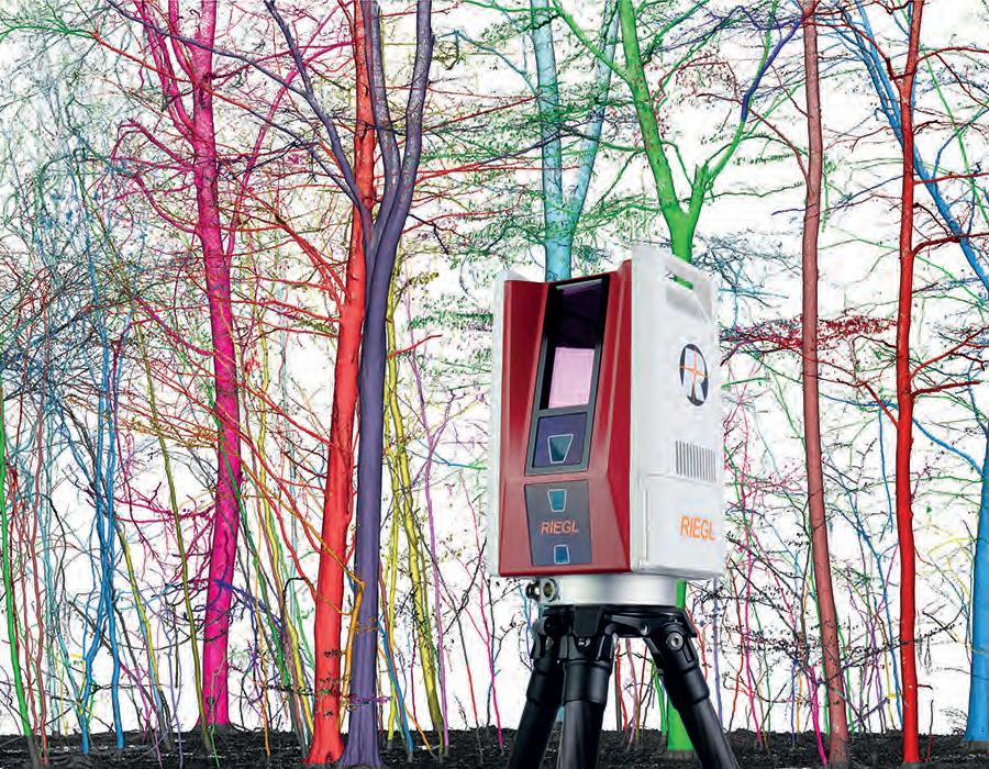
RIEGL VZ-600i: Highly accurate and informative point-cloud data, e.g. for single tree segmentation in forestry.
Which advancements or improvements have been made to your products in recent versions?
With the introduction of the RIEGL VZ-600i, we achieved a milestone in 3D terrestrial laser scanning. The VZ-600i stands for extreme versatility, high productivity, ultimate performance and additional mobility, plus provides an excellent return on investment. Its key features include onboard processing that speeds up the workflow indoors and outdoors. In combination with recent software developments, the customer experiences a straightforward and transparent workflow from data acquisition to the analysis of the data.
Newer products in the market will challenge further user-friendly enhancements in drone-based laser scanning relying on
tight integration of Lidar, GNSS and inertial data. With easy-to-use workflows, we focus on minimizing the effort and time for data acquisition and processing to enable a fast display and analysis of the collected data. With the RIEGL VUX-18024 we offer a Lidar scanner with an extremely high scanning speed of 800 lines/second, ideally suited for corridor mapping. Our nadir, forward, backward (NFB) scanning technology – as featured by the VUX-12023, VUX-16023 and VQ-680 scanners – allows our customers to exploit RIEGL’s waveform Lidar technology with its highest measurement rates, scanning rates and multiple scanline directions. This innovative scan pattern also allows the detection of vertical targets such as high-voltage pylons, house facades or steep mountain slopes.
Jürgen Nussbaum has been with RIEGL since 1995. After initially working in mechanical engineering and production, he joined the RIEGL sales department in 1999, which he has been heading since 2010 as director of international sales, and since 2022 as chief sales officer (CSO).
Teledyne Marine
To celebrate Geo-matching’s 10-year milestone, we are highlighting some of the companies showcasing their products on our online comparison platform. How do they set themselves apart in the market? And which key features should buyers consider when making purchasing decisions? Here, Teledyne Marine shares insights into its recent advancements and improvements, as well as its strategies for staying ahead of industry changes.
How do your products differentiate themselves from other solutions on the market?
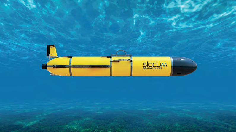
At Teledyne Marine, we have distinguished ourselves through the advancement of our technology and unparalleled durability while providing a user-centric design. Teledyne’s line of autonomous underwater vehicles (AUVs), gliders and sonar systems together provide customized solutions using advanced, critical technology that has been developed to optimize reliable and precise data collection while reducing operational costs using sustainable products.
Our commitment to sustainability sets our product line apart. Equipped with high-resolution sensors and imaging systems, our gliders and AUVs offer precise data collection capabilities. Present and future environmental concerns require technologies that embrace sustainability and conservation, designed to minimize the impact on marine life while maximizing data collection efficiency. Our vehicles can be customized so that users can adjust the payloads to fit their specific requirements, whether for environmental monitoring, surveys or defence purposes. Teledyne’s eco-friendly design is crucial as the industry moves towards more sustainable practices.
Meanwhile, our Teledyne Marine multibeam sonar solutions stand out due to their wide swath coverage and high-frequency capabilities. The multibeam system includes a quarter-degree beam width at nadir, enabling surveyors to map expansive underwater areas with high precision in a fraction of the time. This is all done without sacrificing detail and accuracy. Our sonars can do this by utilizing advanced adaptive
gating technology, which minimizes false detections while reducing the effects on the marine environment.
When purchasing your products, what features are the most critical to consider?
Our gliders and AUVs offer essential features like advanced navigation and communication, ensuring accurate positioning and effective communication. Clients can customize payloads with sensors to fit specific mission requirements, with engineering that ensures their vehicles perform reliably over long periods and in harsh environments. The durability of the systems provides reliability in harsh environments for long-term, trouble-free operations, setting our products apart from other market solutions.
The Sonar User Interface (SUI) seamlessly integrates with the surveyor’s workflow, providing more intuitive control and real-time feedback. Its user-friendly features include colour-coded 3D point cloud displays, advanced visualization tools, and automated parameter adjustments. This intuitive design helps to ensure that the most complex systems are easy to operate, making for a natural extension of the user’s experience. The wide swath and high resolution provide comprehensive, detailed mapping of large areas quickly and efficiently.
What do you anticipate for the future development of technology, and how do you plan to stay ahead of these changes?
Teledyne Marine products are at the pinnacle of subsea technology, ensuring precise positioning and reliable data transmission with autonomous operation. The future is geared towards greater automation, enhanced data accuracy and sustainability. We are staying ahead of these changes by continuously innovating and integrating advanced technologies.
poised to enhance oceanographic monitoring across a variety of applications.
With further advancement in AI-driven data analysis and real-time environmental monitoring, Teledyne is at the forefront of investing in research and development, and collaborating with leading scientists and industry experts to push the boundaries of what is possible in the marine technology space. We continue to strive to meet the current and future needs of the marine industry by providing cutting-edge, sustainable products with advanced features and improved mission efficiency.
Which advancements or improvements have been made to your products in recent versions?
When further developing our AUVs, gliders and sonar systems, we maintain our focus on increased automation, precision
and sustainability. As a result, our latest products feature high-resolution sensors and customizable payloads, supporting ecofriendly designs essential for the industry. For example, our multibeam sonar systems offer a quarter-degree beam width at nadir for unmatched precision and accuracy.
Advanced adaptive gating technology further improves target detection and data quality while minimizing environmental impact. Another example is the redesign of our SUI for even better usability and efficiency. Looking ahead, we are incorporating AI and machine learning to further enhance our data collection capabilities and operational efficiency, ensuring we continue to meet the evolving demands of the subsea sector with sustainable, state-of-the-art solutions.
Rhonda J. Moniz is a published author, conservationist, scientific diver, ROV pilot, journalist and filmmaker specializing in diving technologies and underwater forensics. She has overseen multiple expeditions, trained law enforcement professionals and the military, and hosts a podcast on ocean technology.
Hands Off, Precision On: SeaBat Leads the Way!
Say goodbye to manual controls and time-consuming data processing.
The SeaBat adjusts the settings automatically and making sure you always get the best data output.
The SeaBat T-series is your underwater ally if you want to eliminate constant supervision allowing you and your crew to focus on what truly matters.
Receive clear data that minimize the need for extensive post-processing.
Let us show you how it’s done.
Scan the QR code to get data.
Vexcel Imaging
To celebrate Geo-matching’s 10-year milestone, we are highlighting some of the companies showcasing their products on our online comparison platform. How do they set themselves apart in the market? And which key features should buyers consider when making purchasing decisions? Here, Vexcel Imaging shares insights into its recent advancements and improvements, as well as its strategies for staying ahead of industry changes.
How do your products differentiate themselves from other solutions on the market?
Vexcel consistently goes the extra mile in UltraCam camera design, enhancing flying efficiency and data quality for our customers. Our approach positions our solutions as leaders across the fundamental, premium, and integrated-system segments. For example, our proprietary Adaptive Motion Compensation (AMC) is the only solution on the market that compensates for motion blur across multiple directions, rotations and even scale changes, delivering consistently sharp imagery with low ISO settings for utmost image quality. Secondly, for our fundamental camera line-up, we have chosen a design that does not require tilting cones, thereby avoiding any artificial interpolation. A third example is our attention to small details. We’ve integrated sensor shifts along with cone tilts in the left and right oblique cones of our Osprey. This adjustment maximizes ground resolution and coverage, capturing detailed and comprehensive imagery where it matters most. And last but not least, our hybrid aerial mapping system, the Dragon, sets the industry standard for integrated systems by combining Vexcel’s leading camera technology with a revolutionary new Waveform Lidar scanner from RIEGL. With an innovative Lidar scan line pattern featuring five cross directions of ±20°, ±10° and nadir, the Lidar ensures unparalleled coverage in urban canyons as well as on facades and linear structures.
On the processing side, usability and a rich set of innovative features differentiate UltraMap from other software systems. Features such as automated colour balancing and the AI-based water mask save our customers a lot of manual work, and lead to stunning, consistent and repeatable results.
When purchasing your products, what features are the most critical to consider?
When purchasing a Vexcel product, you’re investing in a comprehensive ecosystem designed for long-term success. Each UltraCam system leads its market segment, meaning you can’t go wrong with an UltraCam. Key considerations for selecting the right system include budget constraints, the need for oblique capabilities, and the importance of Lidar data. For instance, the Eagle excels in photogrammetric nadir, the Osprey combines nadir and oblique photogrammetry, and the Condor is suited for wide-area mapping, each with superior image quality and efficiency. The Merlin offers fundamental nadir image quality at a lower cost due to its simpler camera concept. And if Lidar data is crucial, the Dragon is the ideal choice.
Beyond the system itself, I always recommend considering operational efficiency, such as the learning curve and the intuitiveness of the system operating software – which is consistent across all UltraCams. Our 24/7 worldwide support ensures help is always available. Additionally, we support scalability through system upgrades or trade-ins, complemented by webinars, user group meetings and other resources to help with troubleshooting and to maximize each customer’s investment. Partnering with Vexcel means you get more than just an UltraCam; you’re investing in technology that will drive your business forward by ensuring your chosen system delivers significant business value and integrates smoothly into your operations.
What do you anticipate for the future development of technology, and how do you plan to stay ahead of these changes?
At Vexcel, we recognize that the future of technology is shaped not only by our innovations, but also by the people behind them. Our team of developers, engineers and experts are central to our success. They are deeply knowledgeable and continuously strive to advance their skills and understanding of emerging technologies. This commitment to professional growth ensures we remain at the cutting edge of the industry.
On the hardware side, our strong connections with key suppliers, particularly imaging sensor providers, offer us invaluable insights into their development plans. This allows us to influence their roadmaps and anticipate new technologies, enabling us to strategically plan our camera roadmap years in advance. Such foresight guarantees that our systems continue to set the standard for excellence. In the realm
machine learning. These partnerships enrich our processing software, UltraMap, with a continuous stream of innovative features that enhance its capabilities, streamline workflows, reduce operational costs, and improve customer outcomes. These advancements not only benefit our clients, but also ensure our tools evolve in line with industry demands.
Which advancements or improvements have been made to your products in recent versions?
On the camera side, the fourth generation is now complete with the premium line, which includes the Eagle 4.1, Osprey 4.1 and Condor 4.1. All these cameras utilize the sophisticated concept of pansharpening, are fully CMOS-based, feature AMC, and incorporate new computer and storage systems for a fast frame rate of
0.7 seconds. Consequently, they are faster, more effi cient, deliver higher quality data, and are lighter and require less power compared to their predecessors. The newly announced Merlin family, part of our Bayer pattern line-up, sets a new standard in the fundamental camera segment with its support for AMC and the elimination of the need for tilted cones for full-frame nadir imaging. The newly announced Dragon is now on the market, with the fi rst systems already shipped to customers. A sample dataset from Graz, Austria, is available, and another will be captured over India in September. We invite everyone to evaluate the data quality fi rst-hand. On the software side, we recently implemented automated water handling into UltraMap, which signifi cantly reduces manual labour in the workfl ow and ensures uniform ortho images over water areas.
CEO of Vexcel Imaging since 2008, has expertise in aerospace and telematics technologies
standards. With degrees in aerospace and aeronautics, plus an MBA, his strategic vision and leadership help to continually drive technological advancements.
YOUR SUCCESS IS OUR MISSION!
We are global leaders in aerial imaging solutions. Our UltraCam systems, the most advanced cameras and hybrid mapping systems, along with our UltraMap photogrammetry software, support you best in achieving your project goals.
Industry experts discuss the past decade and what’s next
The geospatial sector unpacked in six questions
By Wim van Wegen
In celebration of Geo-matching’s 10th anniversary, we invited four prominent geospatial experts to shed their light on the most impactful technological advancements over the past decade. This roundtable focuses on the evolution of the industry, particularly in the areas of uncrewed platforms, data processing, and the future trends. Their insights give us a clearer understanding of how these advancements have driven the industry forward and are poised to reshape the geospatial landscape.
Introducing the experts
Our esteemed experts are: Jonathan Murphy, CEO of GoGeomatics Canada, Linda Foster, strategic visionary at Esri, Chris Trevillian, director of product go-to-market geospatial at Trimble, and Lee Hellen, CEO and founder of Kurloo Technology. With their extensive experience across various sectors within the geospatial industry, these experts bring a wide range of perspectives.
Which technological development has had the most impact on the geospatial industry in the past decade?
• Jonathan Murphy: The integration of artificial intelligence (AI) and machine learning (ML) with geospatial data has been one of the most transformative developments. The ability of AI and ML to automate data analysis and pattern recognition has significantly enhanced decision-making capabilities across industries. This shift has enabled more accurate predictions, efficient workflows, and the ability to handle vast geospatial datasets in real time. It’s incredible to see how AI has unlocked new possibilities, turning raw data into actionable insights like never before.
There have certainly been a number of technological developments in the last decade, so it is tough to pick just one. However, I would have to say the maturing of cloud computing and communication infrastructure has to be close to the top. It really allows us to leverage all of the other advancements in geospatial technology to their fullest potential. A close second is the growth of GNSS globally. Expanded coverage and more robust accessibility have enhanced and broadened what we can do and how we do it, and in a more accelerated state.
Chris Trevillian: The two main technological developments I believe have had the biggest impact on the field users in the geospatial industry during the past decade are firstly, the broader adoption of remote sensing technologies, including 3D laser scanning, mobile mapping systems and UAS, and secondly, the rise of sensor fusion hardware like GNSS+IMU receivers. These two developments have unlocked massive productivity and safety gains in field data capture routines. In the office, my vote would be for the more recent developments in machine learning techniques which have sped up the process of extracting meaningful information from these large remote sensing datasets.
If I were to select one, it would be positioning navigation and timing (PNT) by virtue of providing a foundation for all geospatial
Linda Foster
information. With the decreasing costs of space launches, the future for PNT and Earth observation (EO) looks incredibly influential. There are also many other layers of technological innovation – such as robotics, Lidar sensor systems, cloud and AI – that have already been highly influential over the past decade. Geospatial information advancement combines both technology and policy, so success would not have been possible without the national policy and international collaboration to allow those technologies to proliferate.
What are your views on the evolution and current state of uncrewed platforms in the geospatial and hydrographic sectors over the past ten years?
• Jonathan Murphy: Uncrewed or unmanned aerial platforms like drones/UAVs and autonomous underwater vehicles (AUVs) have revolutionized the geospatial and hydrographic sectors, evolving from experimental tools into indispensable assets. These uncrewed platforms offer unmatched efficiency as they can cover areas that were once difficult or impossible to survey, often at very reasonable costs. Advancements in sensor technology and autonomous navigation have also evolved and expanded their application. From environmental monitoring to infrastructure inspection, these platforms are now integral to modern surveying, providing highresolution data at a fraction of the time and cost compared to traditional methods.
• Linda Foster: Uncrewed platforms have become mainstream over the past decade thanks to advances in positioning communication and (micro)computing capabilities. Unmanned aerial vehicles (UAVs or ‘drones’) are perhaps the most deployed in the geospatial sector, but other types of uncrewed systems – such as unmanned surface vessels (USVs) used for hydrographic surveying – take advantage of
“We’ve gone from the everyday surveyor processing baselines and traverse adjustments, to now processing complex reality capture data”
sensors that can provide a much wider range of remote sensing capabilities. The entire workflow – from mission planning and deployment, to processing and deliverable creation – has been streamlined to a point where almost all customers I speak with have some element of UAS deployed in their business.
many of the same advancements. They will undoubtedly continue to evolve, but have already established themselves as an important part of the geospatial arsenal.
• Chris Trevillian: It has been really amazing to witness the rapid change and adoption of uncrewed systems over the past decade. Ten years ago, the sensors were not well integrated, and the systems had limited awareness of their surroundings, which required a lot of pre-planning and logistics to have successful missions. Today, these systems carry a multitude of well-integrated
• Lee Hellen: Autonomous systems provide the ability to offer safer, more frequent, and temporarily precise solutions. This provides higher volumes of data that are more powerful for improving the confidence of change detection and geospatial analysis. I believe we are only just commencing the next digital age where data volumes from autonomous systems will become a major challenge for our industry. Providing truth or meaning from these systems will require our industry to extend our professional capability and capacity to allow our communities to operate with greater confidence and creativity to address and overcome the challenges of the future.
How has data processing evolved over the past decade?
• Jonathan Murphy: Data processing has seen a leap forward with cloud computing and parallel processing enabling real-time analysis of massive datasets. The rise of big data analytics and advancements in artificial intelligence and machine learning has also streamlined the extraction of meaningful insights from raw data. These developments have made processing faster, more accurate
and scalable, allowing professionals to focus on data interpretation rather than data handling. In my opinion, the transition from desktop-based processing to cloud-based platforms marks a significant shift in how the industry currently operates.
• Linda Foster: I would circle back to my answer to the first question here. Advancements in computing, both onsite and offsite (cloud) as well as onboard capability, have really been game changers. They have unlocked some of the capabilities available to us for a long time, but we could not fully realize them due to computing limitations and/or the prohibitive cost of handling and processing the data. Computing power has also enabled ML and AI to take our data processing capability to new levels.
• Chris Trevillian: We’ve gone from the everyday surveyor processing baselines and traverse adjustments, to now processing complex reality capture data. This has pushed advancements in our industry’s software capabilities while necessitating the unlocking of computing power in GPUs and cloud computing. We are now seeing much of the manual processing being replaced by machine learning and artificial intelligence, allowing our industry experts to make use of more complex data in easier and more efficient ways.
• Lee Hellen: Advancement in software systems has become a major focus for leading technology providers. Customers want solutions, so leading technology providers focus on providing a
holistic solution. Many packages are moving to cloud or web-based software as a service, where a third party will process information on your behalf, decreasing the time and cost to reduce or process
“The push towards greater automation and the use of uncrewed systems will continue, with a focus on improving autonomy and data quality.”
the data yourself. One challenge remains around metadata or standards to which that data and results are presented: for geospatial experts, the limitations of any data processing outcome must be fully understood and interpreted.
In what ways have market demands shifted in terms of survey instrument features and capabilities over the past decade?
Jonathan Murphy: There has been a growing demand for ease of use, multifunctionality and interoperability. Users now expect survey instruments to be compact yet powerful, with intuitive interfaces that automatically reduce the learning curve. There’s also a growing demand for multi-sensor integration and seamless data transfer between devices and platforms. This shift reflects the industry’s need for flexible, versatile tools that can adapt to diverse project requirements while maintaining high precision and reliability.
Linda Foster: In my experience, the market has demanded better interoperability, efficiency and, of course, accuracy, which has been realized in several ways. Some examples of this include robotic total stations, integrated surveying capability (GNSS and total station together, for instance), the addition of photogrammetric and Lidar data acquisition, rod tilt compensation, auto-levelling, and so on. The result has been smaller crew sizes, often improved productivity and, in many instances, safety advantages.
Chris Trevillian: The market has shifted to embrace the changes in technology, mostly related to reality capture data and sensor fusion. Most customers today require the productivity gains inherent in these two technologies to counterbalance the labour-force challenges. I am seeing a general shift away from datasheet specs and a shift more towards the business-tangible elements that can be realized with new equipment procurement. Everyone’s specs are similar, but the real difference is how easily these features and capabilities are translated to overall business productivity and the quality of the end deliverable.
Lee Hellen: Market demands are focused on saving time and reducing complexity. More compactness, greater flexibility and higher quality achieve this. Robotics has transformed the surveying profession; the days of two-man survey crews are almost gone. This has had a negative impact on field training/mentoring aspects to a degree, but has provided a positive in terms of time, flexibility and cost savings for surveying field tasks. Integration of sensors in field instruments, such as tilt meters in poles, helps solve familiar
Chris Trevillian
challenges with everyday surveying. But sensors still have some way to go in surveying instruments to make them even more intelligent in reducing common sources of error.
To what extent have user-interface and software advancements improved the usability of survey instruments?
• Jonathan Murphy: Survey instruments today are more accessible to a broader range of users because of ease of use. Modern interfaces are designed with simplicity in mind, featuring touchscreens, customizable workflows and real-time feedback. These improvements have reduced the learning curve for new users and the likelihood of errors, making it easier to train new operators. Also, the new software being launched can easily integrate with various platforms, which enhances a collaborative work environment and allows teams to work more efficiently and with greater accuracy.
• Linda Foster: Interfaces across platforms seem to be standardizing more with some commonality coming from underlying operating systems. The widespread adoption of mobile devices for routine personal and business interactions also seems to have established a baseline familiarity with mobile computing, making it easier for users to adapt to whatever input device is being used to operate survey instruments. Onboard computing and built-in connectivity have also improved the usability of today’s survey instruments.
• Chris Trevillian: User interfaces have advanced a long way in the last decade – from basic form and 2D map features, to sophisticated 3D model and point cloud visualization in the field with real-time overlay on instrument imagery. This advancement has allowed our users to get closer to the designs in the field and utilize the equipment to make more informed real-time decisions. For example, it’s now possible to take survey-collected data and immediately analyse the as-built situation compared to the design without ever having to go back into the office.
• Lee Hellen: User interfaces (UIs) now cater for varying levels of expertise and applications. A decade ago, it was uncommon for a non-surveyor to use a total station or a GPS. Today, surveyors make up the minority of survey instrument users. This has led to manufacturers creating specific interfaces for those user applications. The interface is now designed specifically for a task, which makes it easier for non-experts to operate survey instruments. This will continue to evolve. Some manufacturers will focus on surveyors with full features, while others will offer lowerpriced UIs that are targeted towards specific tasks.
less time on gathering, assembling and maintaining data currency. Machine learning and AI will also continue to play a key role in supporting these functions.
Which new trends and technologies do you expect to emerge in the geospatial industry in the next few years?
• Jonathan Murphy: We can expect to see further integration of artificial intelligence, machine learning and real-time analytics into geospatial workflows. Advancements in the Internet of Things (IoT) will lead to more interconnected systems, enabling continuous data collection and monitoring. The push towards greater automation and the use of uncrewed/unmanned systems will also continue, with a focus on improving autonomy and data quality. Finally, augmented reality (AR) and virtual reality (VR) are set to play a bigger role, offering immersive ways to interact with geospatial data for planning, analysis and training.
• Linda Foster: I think we will see an acceleration of the ‘fusion’ of the technologies and capabilities that have emerged in the past decade
• Chris Trevillian: I see a big push from our industry to adopt more data interoperability standards. Data and information must flow easily from one system to another without loss of integrity. We must do everything we can to champion the geospatial professional as the key contributor to the integrity of any project requiring geospatial information for decision-making. As reality capture techniques are embraced by a wider range of users, the reliance on cloud-based geospatial services will grow, and so too will their capabilities, allowing industry professionals to unlock geospatial data at scale by utilizing more artificial intelligence and machine learning. These trends will revolutionize geospatial data processing and analysis, enabling automated information extraction, more accurate predictions and enhanced decision-making from this larger volume of geospatial data. AR and MR technologies are set to enhance the visualization and interaction with geospatial data, providing immersive experiences for non-technical users across a wide range of use cases, ranging from site documentation and
contextualization to training, simulation and navigation.
• Lee Hellen: I expect to see a rise in Earth observation and mobile satellite communications. One barrier to globalization for geospatial technology is consistency and confidence in data communications. Many advanced countries like Australia still have technological challenges around consistent data communication in remote areas. This is also the case in most developing countries. The ability to obtain geospatial data anywhere at any time will open up many opportunities for the private and public sector to expand beyond local specialized knowledge. This could result in a space-fuelled, globally connected geospatial ecosystem, guided by more precise and frequent data outcomes, with greater connectivity and interoperability between geographic information systems.
Conclusion
Jonathan Murphy is the CEO, president and founder of GoGeomatics Canada, a leading force in the country’s geospatial sector. In 2020, he was appointed to the ISO/ TC 211 Geographic Information/Geomatics Technical Committee, playing a crucial role in shaping global geographic information standards, and in 2023 he joined the board of directors of buildingSMART Canada. He holds a bachelor’s degree in Archaeology from the University of Calgary, complemented by advanced diplomas in GIS and Applied Geomatics Research from NSCC’s Centre of Geographic Sciences (COGS). Murphy’s contributions to the field have earned him the distinction of Fellow of the Royal Canadian Geographical
Over the past decade, the geospatial industry has experienced significant transformation, fuelled by advancements in artificial intelligence, machine learning, uncrewed platforms and cloud computing. These technologies have revolutionized how geospatial data is captured, processed and applied across various sectors. The insights from our panel of experts underscore the critical developments that have shaped the industry, and the emerging trends that will continue to redefine its future. All of this is reflected in the incredible range of products showcased by Geo-matching.com. With the continued evolution of these innovations, users can look forward to even greater efficiencies, deeper insights and enhanced capabilities so that they can ultimately achieve the specific outcomes they need or aim for in their work.
Geo-matching, in its role as a pivotal comparison platform for mapping and survey equipment used within the geospatial sector and beyond, supports this progress by empowering professionals to make well-informed decisions. By facilitating detailed comparisons of the latest geospatial products and technologies, Geo-matching ensures that industry practitioners are equipped with the best tools to harness these advancements effectively.
Linda Foster leads Esri’s global strategy for land records, cadastre, surveying and land administration, where she drives innovation in geospatial technologies. Beyond Esri, she is currently serving on the board of directors for the National Society of Professional Surveyors (NSPS). Additionally, she has contributed as a mentor in the URISA mentorship network and led the statewide design of low-distortion projections, preparing for the National Geodetic Survey’s (NGS) upcoming datum updates. Foster is a registered professional land surveyor and a certified GIS professional. She holds a BSc in Geological Engineering and an MSc in GIS from Penn State University.
Chris Trevillian currently works as director of product go-to-market geospatial at Trimble. Preceding his current role, Trevillian has worked as the director of geospatial GNSS product management, helping bring the Trimble R12i GNSS receiver to market. Before joining Trimble in early 2011, he spent eight years surveying in the USA and gained project management experience spanning both the field and office. Trevillian graduated from James Madison University with a BSc in Telecommunications and a minor in Computer Science.
is the CEO and founder of Kurloo Technology, an IoT positioning pioneer, based in Brisbane, Australia. He is a respected leader in the geospatial industry with 25-plus years of consulting experience. Hellen has been an active member for many years of the Geospatial Council of Australia and its predecessors: the Surveying and Spatial Sciences Institute and the Spatial Industries Business Association. His deep involvement in these organizations reflects Hellen’s commitment to advancing the industry, motivated by his commitment to improving work dynamics and building lasting professional connections.
Cutting-edge UAVbased solutions, research and online education
Born from the ITC expertise in Geo-information, the UAV centre has developed cutting-edge research that is now available in online courses tackling specific advanced problems.
Expand your knowledge and skills in a global community of learners. A selection of courses fed by research is available online through the Geoversity platform. They are advanced courses tackling specific problems and several use cases.
To find out more scan the QR-code or visit: ut.onl/geoversity
Tackling the Global Challenges Serving society, benefitting people and the planet
represents the interests of surveyors, land professionals and related professions worldwide members are national surveying and geospatial associations, representing more than 300,000 individuals includes Land Government Agencies & Ministries, Surveying Universities and the Geospatial Industry among its memberships professional work is led by Commissions, Networks,Task Forces and Permanent Institutions will celebrate its 150th anniversary in Paris in 2028 organises events toenhance Networking, Knowledge Sharing and International Cooperation contributes to the global agenda in cooperation with UN agencies and other stakeholders
represents the interests of surveyors, land professionals and related professions worldwide members are national surveying and geospatial associations, representing more than 300,000 individuals includes Land Government Agencies & Ministries, Surveying Universities and the Geospatial Industry among its memberships professional work is led by Commissions, Networks,Task Forces and Permanent Institutions will celebrate its 150th anniversary in Paris in 2028 organises events toenhance Networking, Knowledge Sharing and International Cooperation contributes to the global agenda in cooperation with UN agencies and other stakeholders
can attend FIG Working Weeks, Congresses and other FIG events can be active and have influence on the work and achievements of FIG can contribute to the global agenda making the world a better place
can attend FIG Working Weeks, Congresses and other FIG events can be active and have influence on the work and achievements of FIG can contribute to the global agenda making the world a better place
TASK FORCES 2023–2026
• FIG and the Sustainable Development Goals
• FIG Climate Compass – The Surveying Profession’s Global Response to Tackling the Climate Agenda
• The Role of FIG in international Trends and Future Geospatial Information Ecosystem
• The Surveyor’s Profession: Evolutionary Diversity and Inclusion