The power of 3D: CyArk’s journey in preserving cultural heritage

Interview with John Ristevski, CEO and chairman
Empowering the geospatial community www.gim-international.com
6 2023 Volume 37
history in the high Arctic
in Benin’s
land
Issue
Preserving
Advancements
digital
registry
Mapping subSaharan Africa for humanitarian aid
Special edition: PRESTIGIOUS PROJECTS
RIEGL VZ-600 i
RIEGL’S NEW ERA OF TERRESTRIAL LASER SCANNERS


» broad range capability (0.5 m up to 1000 m)


» 5 sec scan time for low resolution overview scans


» 30 sec scan time for 6 mm resolution @ 10 m distance
» 60 scan positions per hour (with image acquisition)
» 3D position accuracy up to 3 mm @ 50 m

» precise real-time onboard registration


» internal cameras & GNSS receiver

» weight 6 kg / 13 lbs

» prepared for mobile use


NEW
extreme versatility | high productivity | ultimate performance | prepared for mobility Austria | USA | Japan | China | RIEGLWORLDWIDE | Australia|Canada | United Kingdom RIEGL VZ-600i Data Sheet www.riegl.com
Director Strategy & Business Development


Durk Haarsma
Financial director Meine van der Bijl
Technical director Huibert-Jan Lekkerkerk
Contributing Editors Dr Rohan Bennett, Frédérique Coumans
Head of Content Wim van Wegen
Copy-editor Lynn Radford, Englishproof.nl
Marketing Advisor Myrthe van der Schuit
Circulation Manager Adrian Holland
Design ZeeDesign, Witmarsum, www.zeedesign.nl
GIM International, one of the worldwide leading magazines in the geospatial industry, is published eight times per year by Geomares. The magazine and related website and newsletter provide topical overviews and reports on the latest news, trends and developments in geomatics all around the world. GIM International is orientated towards a professional and managerial readership, those leading decision making, and has a worldwide circulation.
Subscriptions
GIM International is available eight times per year on a subscription basis. Geospatial professionals can subscribe at any time via https://www.gim-international.com/subscribe/ print. Subscriptions will be automatically renewed upon expiry, unless Geomares receives written notification of cancellation at least 60 days before expiry date.
Advertisements
Information about advertising and deadlines are available in the Media Kit. For more information please contact our marketing advisor: myrthe.van.der.schuit@geomares.nl.
Editorial Contributions
All material submitted to Geomares and relating to GIM International will be treated as unconditionally assigned for publication under copyright subject to the editor’s unrestricted right to edit and offer editorial comment. Geomares assumes no responsibility for unsolicited material or for the accuracy of information thus received. Geomares assumes, in addition, no obligation to return material if not explicitly requested. Contributions must be sent for the attention of the head of content: wim.van.wegen@geomares.nl.
Benin’s nationwide digital land registry journey
To provide all Beninese citizens the right to access land, bring economic prosperity and prevent land-related disputes, the Beninese government aims to establish a nationwide digital land administration system. With financial support from the Netherlands, the Land Administration Modernization Project started in 2018.
Service in the surveying industry
It is time to innovate with technology that can be applied ‘right here, right now’. That was the clear message during HxGN LIVE Global 2023. Hexagon’s president and CEO Paolo Guglielmini set the tone with his opening keynote speech on ‘Optimism at scale: The power of you, technology and community’.

Empowering growth and efficiency through mapping
El Salvador is embarking on a large-scale project to map the complete country, with the 14 departmental capitals and Surf City mapped at a higher level of detail. The aim is to overcome technological laggardness by updating datasets and sharing online mapping applications for better decision-making.

CyArk’s journey in preserving cultural heritage
John Ristevski, chairman and CEO of CyArk, takes us on the organization’s 20-year journey of digitally preserving cultural heritage sites. Today, the company uses advanced technologies to create accurate and immersive 3D models that don’t just capture the physical aspects, but also document the stories and historical context.
Geomares
P.O. Box 112, 8530 AC Lemmer, The Netherlands

T: +31 (0) 514-56 18 54
F: +31 (0) 514-56 38 98 gim-international@geomares.nl www.gim-international.com
No material may be reproduced in whole or in part without written permission of Geomares.


Copyright © 2023, Geomares, The Netherlands

All rights reserved. ISSN 1566-9076
Preserving history in the high Arctic
In the Arctic Archipelago of Svalbard, the Sveagruva coal mine and settlement were once bustling until their closure. A collaborating team is restoring the area to its natural state. SNSK partnered with the Norwegian Institute for Cultural Heritage Research to 3D-document the site, preserving its history.

Mapping sub-Saharan Africa to enable humanitarian aid
Thanks to collaboration among the world’s largest humanitarian aid organizations and geospatial data providers, there is now a comprehensive map of every building and road in sub-Saharan Africa. The map is supporting public health, education and sustainability initiatives.
Geospatial satellite startup NUVIEW on an ambitious mission
A new and ambitious startup called NUVIEW entered the geospatial satellite industry with a ‘big reveal’ in May 2023, following a long period of secrecy to deliberately keep competitors in the dark. In this exclusive interview, the company’s CEO and co-founder Clint Graumann discusses NUVIEW’s aspirations.

How UAV Lidar improves landmine clearance planning


British mine-clearance charity The HALO Trust partnered with Routescene to undertake a UAV Lidar project in Angola. This case study demonstrates the benefits of UAV Lidar to detect and map minefield features as the basis for informing clearance planning.
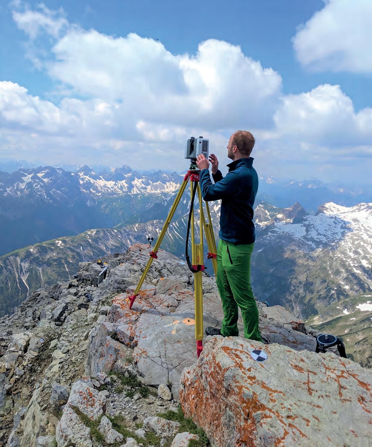
Cover story
The front cover shows a surveyor mapping the Hochvogel – a 2,592m mountain in the Allgäu Alps, on the German/Austrian border – as part of the AlpSenseRely remote-sensing project to study climate-induced natural hazards. The goal is to promote a transnational safety strategy for the region and enhance the availability of natural hazard information for various stakeholders by implementing 3D visualization and decision-support systems.
(Image courtesy: Prof Dr-Ing Christoph Holst, chair of Engineering Geodesy, Technical University of Munich, www.asg.ed.tum.de/gds)

3 Contents Issue 6 2023
5 Editorial 7 Headlines 36 Perspectives 48 Intergeo Preview 50 ISPRS
10 28 14 33 20 39 24
www.gim-international.com Preserving history in the high Arctic Advancements in Benin’s digital land registry Mapping subhumanitarian aid The power of 3D: CyArk’s journey in preserving cultural heritage Interview with John Ristevski, CEO and chairman Special edition: PRESTIGIOUS PROJECTS To subscribe to GIM International go to www.gim-international.com/subscribe
43


Provoking thoughts
I am once again honoured to be writing the editorial column for this ‘Prestigious Projects’ issue. Just like last year, this seems to be one of the more difficult editorials to write – not because of a lack of inspiration from the projects featured in this edition, but because it is impossible to select one as being more prestigious than the rest.
That set me thinking about the meaning of ‘prestigious’. Right now, I have a digital stack of around 60 papers that need to be graded, a summer camp of students to be kept in check (thankfully with help from Boskalis, QPS and Fugro) and several other projects requiring immediate attention. All of this is pretty run-of-the-mill stuff that crops up every year around this time. Stressful? Yes. Prestigious? No!
So what makes something prestigious? Recently, I organized the grading of our bachelor students’ theses. Each student had done five months of research into a topic that should contribute to general hydrographic knowledge as well as to the organization where they did the research. The subject should be interesting, novel and provoke new thoughts. However, not all of the students’ theses did provoke new thoughts. Some were very well-executed research projects that provided solutions to a new or existing problem. Some of them could have been prestigious, but were not presented in a sufficiently thought-provoking manner.
Nevertheless, a few were actually deserving of the term ‘prestigious’, in my opinion: wellexecuted research into a topic that sparks discussion or sheds completely new light on the matter. In fact, the topic that sparked the most discussion was not the highest-


graded thesis or the best executed research from an academic perspective. Besides the good, solid research, what made it most thought-provoking and therefore potentially prestigious was the clear presentation. The subject was the application of medical 3D software for shallow sub-bottom profiling of geophysical data in order to determine the possible locations of 18th-century wooden shipwrecks at the soft, silty bottom of the sea. No wrecks were definitively located, but some high-potential areas were identified which might not have been as clear with conventional 2D representation. None of the described methods were completely new, but their combination in this context made the research definitely thought-provoking and probably prestigious.
My thoughts then turned to our first and second-year students. Every year, they are required to use GNSS, photogrammetry, and singlebeam and multibeam echosounding to survey the entire harbour area around our university of applied sciences. The concept is tried and tested, providing that things go as planned. But this year, it was the maiden voyage of our very own unmanned surface vessel (USV), a second-hand, modified device donated by Van Oord. Initial teething troubles were quickly solved and it – and all the other equipment – was soon up and running. But then, just like in the real world, ‘Murphy’ joined the project. After the outboard engine on the survey launch gave out, some first-year students took the initiative and decided that, due to poor RTK reception, they needed to replace the rover on the USV – which inadvertently also changed all the communication parameters. This was not the actual problem (too close to a very high base station, telemetry overshoot) and several days were lost sorting everything out. Then just when everything was running smoothly again and survey data was being collected, Murphy struck again
5 Editorial Issue 6 2023
in the shape of a rather ferocious bird that attacked our small A1 drone, reducing it to a collection of plastic and electronic parts. The drone was replaced the very next day (long live online shopping!) and the survey was eventually concluded within the deadline, albeit with multiple stressful moments for the students. So is this an example of a prestigious project? I can’t say that the results of the survey were very striking or innovative. The students (and supervising lecturers) definitely overcame challenges to set everything straight. And in the end, the entire allocated area was surveyed and reasonable data was collected. Despite all the issues (some of which were self-inflicted), it was a great achievement for the students and they themselves will probably consider it ‘prestigious’. But from my perspective, it’s not thought-provoking enough.
This brings me back to the articles in this edition. The projects featured in these articles may well have had a visit from Murphy too, but if so, that will probably not receive much of a mention. In fact, we rarely get to hear about such issues – even though, in my view, the most important skill of a modern-day surveyor is to identify the real problem and fix it ASAP to get all the expensive high-tech equipment up and running again.
I will leave it to you to think about your own definition of ‘prestigious’, but I hope you find the projects featured in the following pages as thought-provoking as I do!


 Huibert-Jan Lekkerkerk, technical editor
OMNI VIEW, OMNI POTENT


Turns to see moreTilts to see enough
Introducing WARP Omni : A transformative gigapixel aerial camera offering unparalleled productivity and flexibility. Doubling the oblique views and nadir frame size, in half the size of other systems. Versatile, autonomous and highly competitive with satellite and UAV imaging for mapping, smart city, and wide area monitoring.


6 Issue 6 2023
Learn more at stellar-vision.com
Advanced Navigation presents IMU developments


Advanced Navigation, a renowned provider of artificial intelligence (AI) for robotic and navigation technologies, has unveiled an expansion of its Boreas digital fibre-optic gyroscope (DFOG) range with the introduction of the new A Series. This development showcases the company’s commitment to meeting the escalating demand for ultrahigh-accuracy solutions, even in the most challenging conditions. The Boreas A Series, comprising the A90 and A70, are strategic-grade inertial measurement units (IMUs) that offer great precision, stability and reliability in providing acceleration and orientation data without relying on GNSS. One of their standout features is automatic gyrocompassing, boasting significant reductions in size, weight, power and cost (SWaP-C) when compared to competing systems in the market. Xavier Orr, CEO and co-founder of Advanced Navigation, expresses his enthusiasm about the latest technology: “Our world-first Boreas DFOG technology represented a step-change for fibre-optic gyroscopes. The addition of the A Series ensures we have greater ability to meet the rapidly growing demand for ultra-high-accuracy solutions, even in the most demanding conditions.”

Woolpert and Ecopia collaborate to create 3D maps of Australian metropolitan areas

Ecopia AI and Woolpert have expanded their partnership to map Australia’s top metropolitan areas in 3D. The resulting vector maps will provide Woolpert’s Asia-Pacific clients with a detailed, accurate and up-to-date foundational layer of geospatial data that represents the dimensional world as we know it. As a leading geospatial services provider, Woolpert works with government and commercial organizations alike to map and analyse locations for strategic decision-making. Among its clients are municipalities developing smart city technology to foster more sustainable, liveable communities, as well as telecommunications and engineering firms building infrastructure that supports a constantly changing world. This expanded partnership builds upon Ecopia and Woolpert’s previous collaborations. In 2021, the two companies partnered to map the City of Perth in 3D for a state land information authority. Through that engagement, Ecopia leveraged Woolpert’s high-resolution aerial imagery to map all of Perth’s buildings in 3D, plus surrounding land cover in 2D. Ecopia’s AI-based mapping systems were able to digitize these features in just 12 days, with 40% cost savings for the local state information authority.
Artec 3D joins forces with Leica Geosystems to launch Artec Ray II
Artec 3D, a specialist in 3D scanning technology solutions, has introduced the Artec Ray II, a highly precise 3D Lidar scanner specifically designed for digitizing large objects and spaces with exceptional speed and accuracy. The new scanner is the result of a collaborative effort between Artec 3D and Leica Geosystems, part of Hexagon, leveraging the expertise and innovation of both industry-leading companies. The Artec Ray II is capable of capturing a complete dome in just 1.7 minutes, achieving a 3D point accuracy of 1.9mm from a distance of 10m. These features make it an ideal solution for generating digital twins of extensive objects and complex scenes. The data acquired by the Artec Ray II can seamlessly integrate with data from other Artec 3D scanners, such as the wireless and user-friendly handheld Artec Leo. The Artec Leo is capable of capturing highly detailed scans of specific areas of large objects, allowing for the creation of comprehensive 3D models.

7 Headlines Issue 6 2023
The Artec Ray II 3D Lidar scanner is designed for digitizing large objects and spaces. (Image courtesy: Artec 3D)
Sample of a 3D vector map showcasing Melbourne. (Image courtesy: Ecopia AI)
The Boreas A Series, comprising the A90 and A70. (Image courtesy: Advanced Navigation)
Topcon acquires Finnish industrial radio solutions leader Satel

Topcon Positioning Systems has acquired Satel, one of the world’s leading experts and innovators in wireless technology. Finnishbased Satel designs, manufactures and offers high-quality connectivity solutions that enable secure, mission-critical connections, utilizing the best characteristics of a variety of communication technologies for real-life use cases. “After having worked with Satel for over 20 years, we are delighted with this acquisition, which we see as a critical component for the future of our high-accuracy positioning solutions,” said Ray O’Connor, Topcon Positioning Systems president and CEO. “As our products and services have evolved from individual measurement tools to complete, multi-node workflow automation solutions, the significance of advanced communication technology has grown. Through this acquisition we are able to secure long-term access to a key technology component for our portfolio, today and in the future.” Whether onshore or offshore, Satel’s solutions offer mission-critical connectivity for the most demanding industrial applications, from electricity distribution to windmills, from precision
Hanseatic city of Deventer to welcome FIG Commissions 2 and 7

Geospatial professionals and land administration experts are invited to take part in the combined FIG C7/C2 Annual Meeting in the historic Hanseatic city of Deventer, the Netherlands. The gathering will be proudly hosted by the Netherlands Cadastre, Land Registry and Mapping Agency (Kadaster) and ITC, University of Twente, from 2-4 October 2023. The Netherlands offers all the essential ingredients to guarantee an event that will exceed expectations. The country is known for its tulips, windmills and polder landscapes, but it is also recognized as one of the best-surveyed areas in the world. Every square metre has been mapped, registered and documented. Being a small-sized, densely populated country, partly below sea level, and the second-largest exporter of agricultural goods in the world, the management of land and water is crucial in its society. Mapping and surveying are fundamental activities that support the management of land and water. With almost 200 years of experience in mapping and over 100 years of land consolidation, the Netherlands offers an inspiring environment for the FIG C7/C2 Annual Meeting. Not only do the rural and urban environments showcase the important role of this profession, but the institutional and professional context is also renowned for its high-level standards.
farming to port cranes, from weather stations to racing cars, and from real-time passenger information to surveillance systems.
CHCNAV presents pioneering new cameras for enhanced aerial photogrammetry


CHC Navigation (CHCNAV), a leading provider of geospatial solutions, has introduced the C5 and C30 aerial survey cameras offering more precision and efficiency in aerial photogrammetry. These sophisticated cameras seamlessly integrate with unmanned aerial vehicles (UAVs or ‘drones’) and deliver excellent image quality, enabling professionals to fully leverage the potential of aerial surveying. Based on advanced imaging technology, the C5 and C30 aerial survey cameras ensure superior image quality, capturing highly detailed and accurate aerial images for a precise representation of the surveyed area in each pixel. This level of precision significantly enhances data accuracy and provides professionals with valuable insights. Since the C5 and C30 cameras are designed for easy integration with UAVs, they empower professionals to optimize their workflows and achieve remarkable results using existing platforms. Thanks to the versatility of these new aerial survey cameras, they support a wide range of applications including infrastructure planning, environmental monitoring, topographic mapping and disaster management.

Issue 6 2023 Headlines
IJssel. (Image courtesy: Alfred Grupstra/Pixabay)
Precise aerial survey data acquired with the advanced C5 and C30 cameras. (Image courtesy: CHCNAV)
8
Satel is a leading provider of radio technology solutions, catering to both short-range and long-range communication needs. (Image courtesy: Satel)
Hesai and NavVis innovate reality capture through Lidar sensor partnership

A new partnership marks a significant milestone in the field of reality capture: NavVis has selected Hesai as its exclusive Lidar sensor provider for its industry-leading device, the NavVis VLX 3, which enables efficient scan-to-BIM workflows. Hesai Technology is a global leader in Lidar sensor

solutions. Meanwhile, NavVis has gained a stellar reputation for delivering comprehensive and highly detailed reality capture data for digital twin and industrial use cases in manufacturing, especially for factory planning, assembly planning and shopfloor operations. The German company has supported major manufacturing companies like Volkswagen, Siemens and BMW. Its innovative wearable mobile imaging system, NavVis VLX 3, enables laser scanning professionals to efficiently capture and analyse intricate environments, facilitating the accurate and efficient creation of building information models (BIMs). The VLX 3 by NavVis will use Hesai’s all-new XT32M2X Lidar sensor. By choosing Hesai as Lidar sensor provider, NavVis ensures that its solution benefits from the most advanced and reliable Lidar technology available in the market. Hesai’s Lidar sensors offer impressive 120m range performance, accuracy with 32 laser channels, and reliability, empowering NavVis users to capture precise and comprehensive data with extreme efficiency. Based on the joint industry expertise of the two companies, Hesai has designed these Lidar sensors specifically to serve industries such as reality capture, AEC and scan-to-BIM.

9 Headlines Issue 6 2023
Drawing on the industry expertise of NavVis in combination with its own, Hesai has developed specialized Lidar sensors tailored to meet the unique demands of industries such as reality capture, AEC and scan-to-BIM. (Image courtesy: Hesai)
Benin’s journey to a nationwide digital land registry and cadastre


From paper to pixels
By Christelle van den Berg and Luc Groot, Kadaster International, The Netherlands
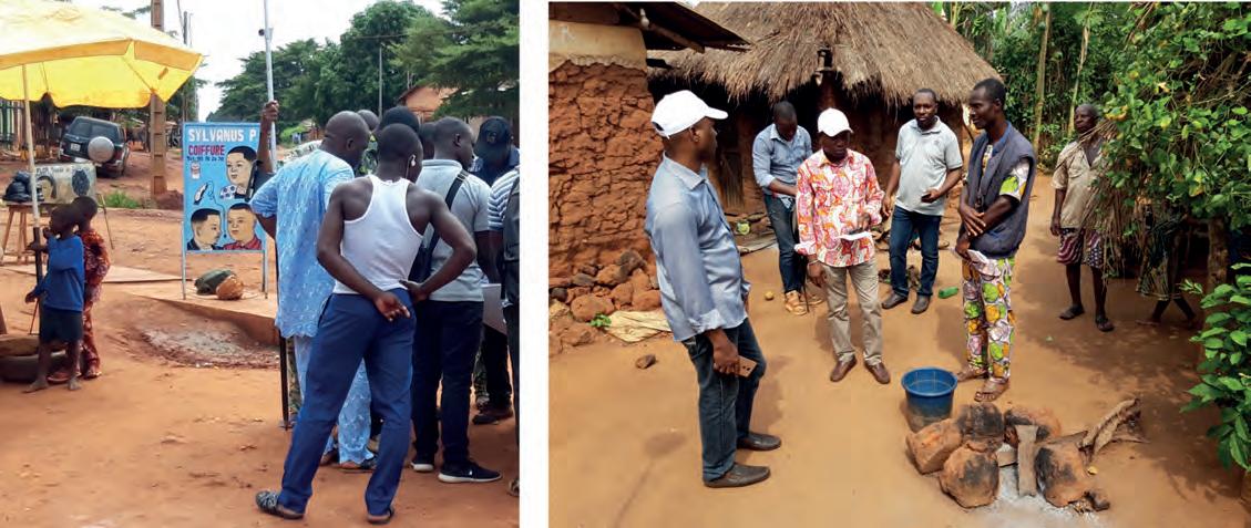
To provide all Beninese citizens the right to access land, bring economic prosperity and prevent land-related disputes, the Beninese government aims to establish a nationwide digital land administration system. With financial support from the Netherlands, the Land Administration Modernization Project (PMAF) started in the West African country in 2018. Unconventional methods have been used in implementing fit-for-purpose land administration, including marking borders using locally produced boundary stones, involving the local population in data collection activities, and registering presumed ownership. The results of the project are promising, with a significant reduction of costs per parcel combined with radical acceleration of the data collection and maintenance process.
With the introduction of the 2013 Land Administration Law and the establishment of the Beninese National Land Agency (ANDF), Benin had decided upon centralized land administration, with the objective of recording the entire national territory in
one digital system. With this law, Benin has opted for a very high level of legal certainty, a Torrens-based system, with the provision of land titles that grant a practically indisputable property right to the natural person or legal entity stated on the title. This property
Issue 6 2023 10
Using a GNSS receiver to measure parcel boundaries. Boundary stone made by local craftsmen.
right is guaranteed by the state and can only be lost through a expropriation procedure described in the 2013 Land Administration Law. Except for the legal transition period of ten years, no further specific measures had been taken to ease the transition to the legally prescribed title system. The following assumptions implicitly provided the support that this approach would deliver the envisioned legal certainty to Benin:
1. That the Land Administration Law compels all landowners, of their own accord, to apply for a land title within a foreseeable period
2. That these title applications and resulting transactions generate a stream of revenue such that ANDF can provide its services in each municipality of Benin.
Five years after the introduction of the Land Administration Law in 2013, it appeared these implicit assumptions would not be satisfied. The legal certainty had increased, but its effect was limited since the transition to titles was progressing more slowly than expected. The procedure for obtaining a land title takes too long and is too complex and too expensive for most people in Benin. In 2018, approximately 45,000 land titles had been issued. By January 2021, this number had risen to about 60,000. This is only a very small part of the total number of parcels to be registered in Benin, which ANDF estimates at about eight million. In 2018, it was already obvious that this process would not succeed in registering land rights for a substantial portion of the Benin territory by the end of the transition period in 2023. This was the reason for ANDF to join forces with experts from the Netherlands in 2018 and jointly find a way to implement nationwide land administration.
Fit-for-purpose land administration customized for Benin
A customized fit-for-purpose land administration approach parallel to the existing system formed the basis for the project execution. Key to speeding up the land administration process was not to establish ownership as absolute right, but to use other verification methods and establish presumed ownership during the period of data collection. Conversion into a higher level of legal certainty, the land title, can be achieved in a later stage, for example, through the application of statutes of limitations. In contrast to the property right documented by a title, this presumed ownership is not absolute and can be disputed; it is applicable until a legal procedure decides otherwise. The introduction of the possibility for later correction provides space for a faster, cheaper and less formal approach that better aligns with the political goal of achieving a land registration system that covers the entire country in a relatively short period of time.
Unconventional implementation methods
Together with the implementing partners – MDF Training & Consultancy, the Association of Netherlands Municipalities (VNG) and Kadaster International – ANDF is using unconventional methods to implement fit-for-purpose land administration. For example, in order to collect the spatial data and the administrative data in 12 municipalities subject to the PMAF project, alternative data collection approaches were deployed. Before the registration process in a specific village or region started, landowners were asked to mark their parcel boundaries using boundary stones. Preferably this was done in cooperation with the neighbouring landowner. These stones were provided by the PMAF project and made by local craftsmen.
About the authors
Christelle van den Berg is a regional manager at Kadaster International. She extends the organization’s knowledge to countries undergoing land administration development, collaborating with ministries, embassies, universities, global businesses and financial partners such as The World Bank and the European Union. She manages expert teams in multiple African countries and actively contributes to the national land administration modernization programme in Benin. With her impressive educational background and over 15 years of experience in spatial planning and geoinformation, she represents Kadaster International on national and international platforms.

Luc Groot is a regional manager at Kadaster International. After studying International Relations at the University of Groningen, he worked as a policy advisor in the European Parliament and as a public affairs manager in Brussels. He also spent eight years working as a project manager, advisor and business developer for an international NGO in the field of agriculture and cooperative development. Before joining Kadaster International, he was secretary and advisor to the board for the Dutch Federation for Private Landownership.

Boundary stones were needed to easily measure and map parcels in Benin as satellite imagery did not always provide information due to the limited natural boundaries between landowners’ land. These stones were handed out in parallel with other local project interventions. For example, the project team trained the local land management committees of the village or commune on the registration process and guidance for landowners on the use of the boundary stones. In this way, active participation of the local community was guaranteed. All collected parcels were put on the same map, which had to be confirmed by the local community members through public inspection.
In the case of conflicts, mediation on the presumed ownership was done by involving local land administration committees. If the mediation failed, the parcel was registered as a conflict parcel. In those few cases, formal proceedings were required outside the scope of the project according to the new Land Administration Law.
Issue 6 2023 11 Feature
In addition, to save time and money during data collection in the field, less accurate equipment for establishing parcel boundaries was used. During testing, it became clear that a measurement accuracy of one metre for all cadastral parcels – both rural and urban – would be sufficient to establish a first reliable and valuable land administration system. This saved costs by enabling budget GNSS receivers to be used, and provided possibilities to train more people in a limited time as data and measuring tools were easier to operate. As an added advantage, landowners better understood the tools that were used, which boosted their commitment. This data collection approach resulted in a more
realistic and cost-effective operation to deliver a land administration system that covers the whole of Benin. The project mapped and registered more than 450,000 parcels in the space of three years.

Fully digital
For the collection of administrative data, a local software developer developed an opensource Android application called the ‘socio-app’. A low-cost commercial Android geodata collection app (Locus GIS) was used for on-site capture and verification of the parcel perimeter. This so-called ‘topo app’ processed the coordinates of the measured boundary points (such as the placed boundary stones) provided by the budget GNSS receiver. In addition, a consolidation application for the integration of the data from both the socio and the topo application was developed. This integration was done on the basis of assigning temporary (project) parcel numbers, with team members exchanging them so that they could each enter the same number for the same parcel in their application.
To store the data from the 450,000 parcels collected initially – and the approximately 7.5 million parcels collected in the future – an IT system called ‘e-Foncier Benin’ was created by a team of
Issue 6 2023 12
Field tests using aerial photography to identify parcels.
Mapping parcel boundaries in urban Bohicon and in rural Tori Bossito.
local software developers. After the field data has been processed in the digital land information system, the temporary project number is replaced by a final unique identifying parcel number, with the original project number remaining available for reference purposes. An important design feature of e-Foncier Benin is that it can visualize the legal status of parcels with a land title and also parcels with presumed ownership in such way that the legal status of the parcel is clear. The development of the e-Foncier Benin national digital land information system is based on the Land Administration Domain Model and is compliant with the ISO 19152 standard.
Sustainable maintenance
Establishing a land administration system is not limited to the collection and safe storage of data. Maintenance procedures are also necessary to keep the data up to date and reliable. A number of major financiers have already expressed their willingness to contribute towards a system of nationwide coverage. In preparation for this, work is currently underway to set up procedures to guarantee sustainable maintenance. The choices made in developing the land administration system allow these procedures to be considerably simplified compared to the current situation. This is because the system can immediately perform checks that normally have to be confirmed by several parties. As a result, the turnaround time of a transaction process can be reduced from several months to just a few days. This will make updating significantly cheaper and faster. The system is also realistic to implement because it is designed to be scalable to national coverage without ANDF having to grow at the same rate.
Significant step in Benin’s development
The Land Administration Modernization Project in Benin is a significant step towards transforming the country’s land administration system, promoting good governance and driving sustainable development. By embracing technology, streamlining processes and enhancing local participation, Benin is ready to unlock its land potential, attract investment and empower its citizens. The project’s successful implementation will serve as a model for other
About fit-for-purpose land administration
The basic idea of the fit-for-purpose approach is that land administration should be designed to meet the need of affordable tenure security for all people in a relatively short time. In Benin, this means that lower accuracy was used in determining parcel boundaries and a limited set of features was used as the start of the development of the digital e-Foncier Benin system. Fit-for-purpose is an incremental approach, and becomes more and more advanced over time.

About Benin
Situated at the crossroads of two vital regional corridors –the Abidjan-Lagos and Cotonou-Niamey routes – Benin offers a lot of potential as a significant West African commercial and tourism hub. With a breathtaking 121km coastline along the Gulf of Guinea, it beckons travellers and traders alike to explore its diverse wonders. Moreover, Benin’s commitment to robust land administration is key to sustaining its economic growth and fostering a thriving business environment. The efficient management of land resources ensures smooth infrastructure development, secure property rights and equitable access to resources. As the country continues to attract investment and tourism, its dedication to sound land governance plays a pivotal role in shaping a prosperous future.
countries facing similar land administration challenges. As Benin marches forward on this transformative journey, it is crucial for all stakeholders, including the government, citizens and development partners, to collaborate and ensure the project’s long-term success. With a modern and efficient land administration system, Benin will be well-positioned to realize its economic and social aspirations while preserving its rich cultural heritage.
Issue 6 2023 13 Feature
Service in the surveying industry
Reflections on HxGN LIVE Global 2023
By Peter Tapken, Geo-matching.com
It is time to innovate with technology that can be applied ‘right here, right now’. That was the clear message during HxGN LIVE Global 2023. President and CEO Paolo Guglielmini set the tone with his opening keynote speech on ‘Optimism at scale: The power of you, technology and community’. Which new geospatial technology was showcased? How does Hexagon envision that this can be instrumental for solving the world’s sustainability challenges? And why does our industry need to ‘put the serve in surveying’? Here, GIM International presents some of the key takeaways.
This year’s edition of Hexagon’s flagship event, the HxGN LIVE Global 2023 conference, was held in the US city of Las Vegas, Nevada, from 12-15 June. More than 3,600 people from 77 countries around the world attended this high-profile showcase of the latest Hexagon technology and applications. The event was also an important information and networking hub for professionals wanting to gain a glimpse of upcoming developments in terms of geospatial sensors, software and autonomous technology, and to learn more about potential future applications.

Supported by stunning audiovisuals, passionate Hexagon executives shared their company’s vision. With a focus on “optimism at scale” (Paolo Guglielmini, president and CEO), the message was clear: it is time to innovate – and not just sometime in the future, but with technology that can be applied “right here, right now” (Burkhard Boeckem, CTO).
Capturing reality across Hexagon’s industries
In his keynote session on ‘Optimism at scale’, Paolo Guglielmini highlighted the company’s
focus on creating the right technology for the Hexagon user communities while achieving opportunities for them at scale. He emphasized human-centric innovation, in which the applicability to users’ needs, technology usability and flexibility in business models is key.
Digital manufacturing for the automotive industry is one inspiring use case demonstrating how Hexagon’s reality capture technology is being used today. Californianbased engineering company Divergent utilizes advanced CAD design software, AI/ML software models for quality optimization, and 3D printing and assembly technology to build digital production lines for printed car parts. Digitizing the production process reduces the need for parts and also for energy, plus all the components can be recycled for future use.
A second highlighted example was in the construction sector, where US-based Mortensen uses digital construction techniques for constructing modular hotels using reality capture and autonomous technology. Thanks to drone flights, photo documentation, real-time progress updates and the use of robotics for the layout of construction elements, construction projects are completed faster and more efficiently using fewer materials. The construction process is also much safer because there is less on-site construction work at height.
Issue 6 2023 14
The latest Hexagon technology was presented in the exhibition area.
Industries are racing to digitize their physical processes, and artificial intelligence (AI), virtual reality (VR) and the metaverse will become increasingly important. Hexagon has intensified its collaboration with NVIDIA, a pioneer in accelerated computing, to combine Hexagon’s reality capture expertise with NVIDIA’s expertise in AI, VR and visualization. Thanks to this strengthened relationship, industrial and construction processes can be AI-optimized using NVIDIA’s virtual worlds. To enable future steps in AI, machine learning (ML) and automation for all Hexagon industries, the company will also connect its Hexagon Digital Reality (HxDR) and NEXUS software suites to NVIDIA’s Omniverse.


Innovation in everything: right here, right now
Hexagon’s CTO Burkhard Boeckem presented the latest technological developments that are available right here, right now. At the heart of Hexagon’s innovation thinking is the belief that industrial technologies need to be as human-centric as consumer technologies. Therefore, all new Hexagon innovations need to be intuitive, efficient and inspiring for any industry and any application, he explained. Some examples of that human-centric approach include the highly intuitive BLK360 laser scanner that was launched at HxGN LIVE 2022, the improved tilt function of the Leica AP20 autopole that has made creating survey points much more intuitive, and the new singleperson-use car mount for the Leica Pegasus RTK mobile mapper. The new HxDR solutions make it possible to process and share digital realities at any scale. This facilitates the visualization of entire cities and environmental simulations with custom industry solutions.
About the author
Peter Tapken is the head of content for Geo-matching.com, the world’s leading product news and sourcing platform for surveying, mapping and autonomy. Geo-matching offers the most comprehensive overview of equipment, instruments and software for the geospatial industry.

Moreover, surveyors can connect Hexagon products to digital twins in the cloud and create new applications powered by HxDR. For example, 2D and 3D subsurface models can be generated from ground penetrating radar data without additional coding. For surveying and mapping applications, the most promising development powered by HxDR is Reality Cloud Studio. Essential reality capture data visualization, collaboration and storage functionalities are made available in a web browser at an accessible price point. This makes it very easy for users to upload their data and provide all project members with access to survey-grade mapping and 3D visualization.
Putting the serve in surveying Morritz Lauwiner, president of the firm’s geomatics division, addressed the changing landscape for surveyors in his keynote on ‘Putting the serve in surveying’. Surveyors are at the core of the surveying profession and need to provide accuracy, quality, reliability, client satisfaction and a professional reputation, he stated. Lauwiner’s main message was that the major technological advancements mean that surveyors need to innovate. But their innovation efforts should go beyond investing in new technology such as accurate sensors and intelligent software. For surveyors, innovation also means that they need to add value by investing in their service level. After all, surveyors are in the service business; they should be not only selling their expertise, but also converting it into a superior service for their end users.
Doug Browning, a surveyor at the US firm Walsh Construction & Archer Western, presented a very informative use case to illustrate this. Besides high-quality survey data and deliverables, his
Issue 6 2023 15 Report
Hexagon president and CEO Paolo Guglielmini kicked off the event with his keynote session.
Californian-based engineering company Divergent explained how it utilizes reality capture for 3D printing. solutions.
company also strives to deliver a superior service by focusing on communication and teamwork, being able to work with different technologies and processes, attention to detail, flexibility, adaptability and availability.
A second example of the added value of technology came from Derek Twente, geospatial service manager at TWM Inc, an engineering firm in the St. Louis region. He explained that new technology improves his current services because new features enable him to better serve client needs and also help him to capture more data with fewer people. As technology is becoming more accessible, the technological playing field is levelling out, according to Twente. It will therefore become increasingly important for surveyors to set themselves apart by focusing on other aspects like improving their service level and other business skills.
Sustainability through sustainable business models
At Hexagon, they are very passionate about sustainability and strongly believe that the technology they create is instrumental for solving sustainability challenges. In key Hexagon business sectors such as construction, industrial facilities and 3D printing, business goals and decarbonization targets go hand in hand. There are multiple examples, including reducing the use of building materials, reducing waste and designing new industrial manufacturing products with recycling or reuse in mind.
In fact, Hexagon has a separate business division called R-Evolution focusing specifically on sustainability, which is seen as one of the biggest business opportunities for the 21st century. R-Evolution’s mission is to accelerate green technology across the world. One example is the project on which research organization Beneath The Waves cooperated with R-Evolution in the Bahamas. According to seafloor sediment research, seagrass captures 10-15 times more carbon than tropical rainforests, and 35 times faster. Using Hexagon’s airborne Lidar solutions, Beneath The Waves was able to measure how much CO2 was stored in the seagrass and sediment in the Bahamas seagrass meadows. The most important discovery is that the Bahamas is potentially the largest nature-based carbon capture reservoir (92km2) in the world. This example illustrates that nature can be an asset in achieving sustainability goals.

R-Evolution is also working on a sustainable business model in forestry conservation and protecting biodiversity, with research outcomes expected to be available next year. It is hoped that these
initiatives will help to build a sustainable business model for similar nature conservation projects around the world.
Other new launches and announcements
Leica Geosystems has launched the brand-new Leica CountryMapper for large-area imaging and Lidar mapping. By integrating a largeformat photogrammetric camera and a high-performance Lidar unit into a single system, the CountryMapper enables the simultaneous collection of foundational geospatial data, resulting in the generation of highly accurate data products to support a wide range of customer applications.
The BLK2GO PULSE, which is planned for release in early 2024, will add a new, unique and disruptive member to the BLK2GO product family. The handheld reality capture device fuses Sony’s advanced time-offlight technology and Hexagon’s GrandSLAM technology to create a fast, simple and intuitive first-person scanning method for mapping from your point of view. It will be primarily used for short-range indoor applications with instant point cloud visualization while you capture.
3 takeaways for the surveying community

Hexagon is building AI solutions and industrial metaverses, and is investing heavily in robotics. Converting digital reality data into land cover layers, classifying models, modelling 3D environments and buildings, detecting changes and managing construction processes are just some of the things that AI can already do. But what does this mean for surveyors? How can they leverage technology to add value? And how can they compete in a landscape in which technology can replace some tasks to a certain extent? These three takeaways from HxGN LIVE 2023 should provide pointers for the surveying community:
1. The technology is already available, including use cases. More accurate sensors and intelligent software solutions are being developed all the time. It is crucial to keep pace with the technological advancements.
2. Focus on developing your market position. Surveyors need to focus on the needs of their main group of customers and users. Adopt technology that strengthens your unique value proposition based on your main surveying applications.
3. To serve is at the heart of the surveyor, and new technology will not change this. Besides adopting technology, surveyors need to maintain and improve their service level.
Issue 6 2023 16
Morritz Lauwiner emphasized the importance of service in the surveying industry.
Mock-up of the Bahamas seagrass project, supported with augmented reality.
The convertible camera is here

A revolving camera for evolving aerial imaging applications


Our fast-changing world demands aerial cameras that are more productive, versatile and cost effective. The WARP Omni convertible camera is engineered to be highly competitive with satellite and UAV imaging, allowing you to leverage your expertise in aerial mapping for a broader range of applications.
Nowadays, aerial images have become essential for various applications beyond just mapping. They are utilized in big data engines to influence multiple aspects of our daily lives, from city planning to agriculture. Images have evolved from raw input to valuable end products. In online maps, the map itself changes minimally, but overlay images are updated periodically.


Trends and challenges


For many applications, relative changes are more important than absolute values. Such applications rely on the availability of regularly collected images as well as accurate geometric, spectral and radiometric information. Consequently, data collection needs to be comprehensive and fast, capturing high-resolution snapshots of large areas quickly and routinely.
Traditional aerial surveys using fixed-wing aircraft now face competition from satellites


above and smaller uncrewed aerial vehicles (UAVs or ‘drones’) below. Although lacking in spatial resolution, satellite imaging provides broad coverage, useful update frequencies and no operating costs for users. Meanwhile, UAV imaging offers unmatched resolution and ease of use but is limited by smaller sensors and shorter flight times. Aerial imaging needs to offer high resolution, long flight times, efficiency and flexible update rates to stay competitive with satellite and UAV solutions. The WARP Omni is designed to ‘capture more, and more often’.


Sponsored article
Figure 1: The WARP Omni camera
Issue 6 2023 17
Figure 2: Image footprints of the WARP Omni in four operation modes.
Standard oblique
Omni oblique
Oblique mapping
Wide-area monitoring
State of the art
The oblique camera system consists of nadir and oblique sensors, which can be either metric medium-format or crop-size consumer sensors. The medium-format sensors offer up to 150 megapixels, providing excellent coverage and accuracy. Their lenses are of high quality, producing sharp and distortionfree images across the frame. Both lenses and shutter are individually calibrated to achieve very high geometric and timing accuracies. The shutter speed can reach 1/2,500s while maintaining precise synchronization in a multi-sensor setup. On the other hand, UAV oblique cameras with crop-size sensors are gaining popularity due to their low cost and ease of use, despite lacking in frame size, lens quality, flight speed and coverage.
The WARP Omni was engineered to not only have all the benefits of a metric sensor system, but also to have double the capacity in key aspects. By improving usability and flexibility while controlling the cost, this enhances the overall cost effectiveness and return on investment (ROI).
Double the views
Oblique cameras capture images along parallel flight lines, with orthogonally placed sensors directing along and across those lines. Buildings aligned with flight lines yield better details than those that are not. Increasing overlap and capturing more images will not yield additional details, as fuzzy inputs cannot provide additional information. UAVs equipped with single oblique sensors, flying in circular mode, can generate precise 3D building models using


fewer images compared to standard fivesensor oblique cameras. The more distinctive views are key to the improvement.


Through fast and precise rotation of the camera pod, the WARP Omni doubles the unique oblique views without a substantial increase in size, weight and cost. In contrast with integrating many smaller-framed oblique sensors, using metrically calibrated, precisely synchronized large-frame sensors eliminates the need to estimate sensor-intrinsic parameters and greatly reduces number of extrinsic parameters to be adjusted in aerial triangulation. This boosts processing speed and improves the quality of 3D results. The rapid, comprehensive and accurate capture of geotagged images of the large area beneath an aircraft is also advantageous for applications such as emergency response, search and rescue, situation monitoring, and wide-area intelligence, surveillance and reconnaissance (ISR).


Half the size
The WARP Omni is compact and selfcontained, packing up to seven mediumformat sensors with image acquisition and storage, flight management and position and orientation system (POS) into a pod that weighs only 30kg. Unlike other metric oblique cameras, its streamlined design and minimal external cabling enables precise and reliable rotation under typical flight conditions. Additionally, its compactness allows for quick installation by a single person, reducing operational costs.
Nadir widens in seconds

Large-format mapping cameras and oblique cameras have traditionally been separate products. As the survey market for 3D reality capture projects continues to expand, it is becoming less advantageous to keep two


separate camera systems. The WARP Omni addresses this by supporting both oblique and nadir mapping modes, allowing for quick transition between them in flight. When commanded, precision actuators adjust the pitch of the left and right sensors until their views overlap with that of the nadir sensor to create a single stitched image with nadir ground sampling distance (GSD), but approximately twice its width. As standard, the WARP Omni is equipped with a 70mm nadir lens and four 110mm oblique lenses. The combined frame width exceeds 27,000 pixels with 80° field of view (FOV). If the left and right sensors are mounted with their long sides oriented cross-track, the resulting frame width reaches 29,000 pixels and 86° FOV.
In wide-frame mapping mode, the front and back sensors can remain at 45° or move together with the left and right sensors. At 45°, they provide along-track oblique views of ground features, enhancing 3D capturing. Meanwhile, the cross-track views form a single image with uniform GSD. This makes the WARP Omni particularly useful for corridor mapping, especially over mountainous terrain where standard oblique angles may result in views falling outside of the corridor area. If the front and back sensors are brought in along with the side sensors, the nadir frame effectively widens along the track. When the camera rotates to capture images in both the + and x directions, the frame coverage expands even further. Moving sensor footprints inwards also prevents obstruction and reduces atmospheric influence on oblique images when they are captured through the optical window of a pressurized aircraft at high altitude. The ability to quickly switch between oblique and nadir mapping modes offers
Issue 6 2023 18
Figure 3: Standard Maltese-cross oblique cameras are less capable of capturing facades of buildings that are not aligned with parallel flight lines.
Figure 4: Difference in ground footprints for cameras in standard oblique (left) and oblique (right) mapping mode when flying over a mountainous corridor.
greater flexibility to tackle applications with demanding quality, time and cost constraints.


Works well with Lidar
Airborne Lidar solutions typically have 60° FOV, and a camera with a similar FOV is often used for reference images. A 150MP sensor with a 50mm lens is common. For a digital elevation model (DEM) mission, a 10-15% overlap between Lidar strips is sufficient, but this is not enough for generating a digital ortho map (DOM) from the images. Thanks to the WARP Omni’s combined nadir FOV of over 80°, images have side overlap of over 35%, meeting photometric requirements. Additionally, the longer focal length provides a 40% improvement in the GSD. Moreover, the camera can operate autonomously or in response to Lidar flight management system (FMS) commands. No separate planning is needed, making it ideal for time-sensitive projects like natural disaster assessment.

Sharp and fast


Flying at high speeds is crucial for productive aerial imaging. The shutter speed needs to be fast enough to capture clear highresolution images from fast-moving aircraft. Mechanical forward motion compensation (FMC) and inertial-aided deblurring techniques have been used to reduce motion blur, but they have limitations. FMC only works for nadir sensors and not obliques, while deblurring is more effective for slower shutter speeds and lower resolutions, and is therefore often used in video rather than single images. In contrast, the WARP Omni uses sensors with an exposure time as low as 1/2,500s. It can reliably produce images with 10cm GSD at speeds over 250kts or 3cm GSD at 100kts. The camera also supports high-performance
image acquisition and storage, allowing for sustained capture rates of up to two frames per second, which is essential for capturing high-resolution images with a large overlap during fast flights. Additionally, a customized gyro mount minimizes the negative effects of vibration and shock on image quality, ensuring consistent performance even in high-vibration environments such as helicopters.
Onboard operator optional
The WARP Omni is built on the same framework as the large-format multi-sensor payloads for long-endurance drones. These products have been successfully deployed in various installations since 2018, and have conducted autonomous missions in challenging environments including surveying, forestry, flood monitoring and earthquake damage assessment.
The camera’s FMS supports fully automatic closed-loop control of cameras and gyro mounts based on uploaded flight plans and position readings. It can also control external sensors like Lidar and hyperspectral cameras, enabling comprehensive data collection. The FMS efficiently handles large flight plans with
thousands of lines and hundreds of thousands of photo points. The entire flight plan can be uploaded at once and executed autonomously, eliminating the need for manual line selection. The camera also supports ad-hoc image collection without predefined flight plans by using GPS positioning and a built-in global DEM. Moreover, the camera actively monitors and logs the health of its major components and environmental conditions.
Flexible and versatile

The WARP Omni offers exceptional flexibility in lens and sensor configurations for a multitude of projects. Users can choose combinations of nadir sensors, including RGB or NIR 150MP sensors, 280MP RGB and hyperspectral sensors. Lens options include 40/70, 70/110 and 110/150 in addition to the standard 70mm/110mm configuration. With its compact design and autonomous capabilities, the WARP Omni is suitable for a wide range of airborne platforms, including fixed-wing aircraft, helicopters and longendurance drones, depending on the project needs.

Tested and proven

Since 2022, the WARP Omni has completed imaging of tens of thousands of square kilometres for diverse and challenging realworld projects including 3D terrain imaging, 3D city modelling and railroad planning. Operations ranging from 500m AGL at 100kts to over 8,000m at 240kts, and with airborne Lidar and spectral sensors, prove its efficiency, versatility, accuracy and reliability.

Sponsored article
Figure 5: The WARP Omni’s wide FOV in nadir mapping mode produces images with more than 35% overlap and 40% higher resolution for DOM when flying with 15% cross-track overlaps for Lidar.
MORE INFORMATION www.stellar-vision.com
Figure 6: The WARP Omni works with fixed-wing aircraft and helicopters.
Issue 6 2023 19
Standard Lidar camera WARP Omni nadir mapping mode Equivalent nadir wide frame
Country-wide transformation using cadastral geospatial information for strategic decision-making
How El Salvador is empowering growth and efficiency through mapping
 By
By
Through the National Registry Center (CNR), the government of El Salvador is embarking on a large-scale project to map the complete country (an area of 20,742km2), with the 14 departmental capitals and Surf City mapped at a higher level of detail. The aim is to overcome years of technological laggardness with an updated dataset and online mapping applications shared across government entities to support better decision-making.
El Salvador is a very densely vegetated country with a challenging topographical landscape, since 76% of the territory features slopes with more than 30% inclination. These characteristics are perfect for growing some of the best coffee
plants, but make mapping difficult. The country is not visible in Street View, and the current general-use map applications (i.e. Google Maps, Apple Maps, Mapbox, etc.) only publish satellite imagery and terrestrial panoramas uploaded by users,
which means at best 0.6m ground sample distances (GSDs).
The 2.7 million parcels that make the CNR’s land registry maps are grouped in individual block-level CAD files, which are difficult to query for specific needs, such as finding lots with particular investment characteristics. Previous orthophotos were ten years old and in low resolution (60cm/px). Land registry and parcel-boundary review processes were paper-based and required field inspections, resulting in processing times of over two months. The inherited state of affairs in El Salvador required action. To reduce processing times, the CNR needed new tools to match the information necessities to support the Presidential Governmental Plan called ‘Plan Cuzcatlan’. CNR’s challenge was to modernize its dataset and tools in record time (two years) at a fraction of the budget used in previous attempts.

From 2D data to omnidata
The updated dataset had two prerogatives: to use the latest technology and to build the capacity within the CNR to update such information by acquiring infrastructure. The 14 most important cities in El Salvador represent over 80% of both the economy and of CNR’s processing requests, so they were prioritized for a higher level of detail. This area, totalling 751km2 , was surveyed for the first time using multiple
Issue 6 2023 20
Public satellite imagery and project imagery at 8cm (El Salvador).
Omnidata, vision 360, oblique photo (El Salvador).
Camilo Trigueros, CNR, El Salvador, and Felix Audirac, CartoData, Mexico
simultaneous sensors. For vertical imagery, a high-resolution photo (8cm GSD) unveiled many details hidden between the pixels. The obliques and Lidar were flown at the same time, providing the capacity to see the building facades, understand multistorey constructions on the side of the cliffs, and quantify the buildings under the trees.
The rest of the country was surveyed at 20cm/px resolution providing countrywide coverage. To update the aerial part of the dataset, fixed-wing and multirotor uncrewed aerial vehicles (UAVs or ‘drones’) were acquired by CNR. Drones complement crewed surveys by quickly providing highly detailed imagery for small areas (of less than 5km2).
Street mapping has become such an essential part of geospatial datasets that it is hard to imagine finding directions – or managing a country – without it. Cities are constantly changing, so CNR targeted the long-term game. Instead of contracting out the mobile street mapping, the organization decided to learn by doing. As 1,750km of streets were travelled, the designer of the mobile mapping platform transferred the knowledge and capacity to CNR’s technical staff. The El Salvador Maps mobile mapping unit is now on its way mapping over 250km per month.
Evolving to web mapping applications


Mapping operators previously had to go through many server directories to find the correct orthophoto sheets and vector files,
then load them into the client to perform a specific procedure on a parcel. This could take 10 to 45 minutes, depending on the complexity and size of the area. The ‘El Salvador Maps’ project consolidated isolated files into a single geodatabase. Now, it takes no more than 10 seconds to zoom into a specific area and get started.
Everything runs on eCarto, a PostgreSQL DB and a .NET web stack. Among the online mapping apps developed for this project, three stand out: cadastral maintenance, vertical condominium management, and forsale data preparation. Cadastral maintenance allows CNR’s operators to validate property coordinates provided to the omnidataset and gain an accurate understanding of the situation from their desks. Subdivisions,
Issue 6 2023 21 Feature
Coverage comparison of user-uploaded panoramas vs El Salvador Maps.
The El Salvador Maps mobile mapping unit and UAV field crew.
Push the boundaries of 3D laser scanning.


You make the impossible possible—going where others don’t want to go and achieving what others can’t. You lead the way in capturing and documenting the world around us with unparalleled accuracy and detail.
Push the boundaries of 3D laser scanning with powerful in-field automated registration, on-the-fly measurements, and annotations. Trimble® 3D laser scanning systems enable you to visualise and verify your projects before leaving the site, so you can capture complex real-world data with the confidence of getting it right the first time.
Find

out more at:
geospatial.trimble.com/3D-laser-scanning-solutions
© 2023, Trimble Inc. All rights reserved. GEO-225-en-UK (05/23)
fusions and boundary rectifications can be done through the platform by updating existing cartography online. Meanwhile, vertical condominium management has always been a challenge in 2D environments. The evolution to 3D has provided the flexibility required to address multiple ownership rights in the same building.

Last but not least, citizens, companies and other government entities regularly request specific areas of interest from CNR. The preparation of such datasets was highly demanding in terms of manpower, as a jigsaw of different sources needed to be assembled to achieve the requested task. All three above-mentioned applications have transformed CNR’s ability to respond faster to end users, including by offering reduced processing times.
Empowering decisions
The highest decision-making authority in El Salvador is the President and the Congress. Decisions are fast-paced and require equally fast provision of information. Thanks to the new omnidataset and tools provided by El Salvador Maps, CNR has been able to provide timely information to support the design and construction of the country’s second international airport, the Pacific Train, infrastructure for law enforcement, and green energy generation clusters (solar, wind and volcanic).
Moreover, in search of budgetary and bureaucratic efficiencies, on 1 June 2023 the nation’s president announced plans to
Camilo Trigueros is executive director of the National Registration Center (CNR), El Salvador.


As a lawyer and Notary of the Republic, he is a professional who has worked in legal sciences, international relations, intellectual property and trade policy, among others. He graduated from the José Simeón Cañas Central American University (UCA) in 2003 with a degree in Legal Sciences and obtained a master’s degree in Intellectual Property from Austral University (Buenos Aires, Argentina).
Felix Audirac is CEO of CartoData, Mexico, lead of the mapping company implementing ‘El Salvador Maps’. With a master’s in Business Entrepreneurship & Technology and a bachelor’s in Computer System Engineering, he is a geospatial information technology evangelist with over 20 years of experience. His efforts are focused on democratizing the geospatial information generated by CartoData through exponential technologies such as cloud computing, mobile devices, drones, blockchain and artificial intelligence.
reduce the current 262 municipalities to 44. The new municipal boundaries will be aligned with topographical features, landownership rights will be allocated to the right municipality and the territory will be constitutionally delimitated, all supported by a well-georeferenced framework.
The prestigious ‘El Salvador Maps’ project
A prestigious project generates the perception of achievement through quality, usefulness and the right use of technology.
Three elements need to coexist for such a project: 1) high-accuracy data, 2) powerful tools to be leveraged, and 3) new processes to turn data into information and empower decisions. CNR has accomplished all three. El Salvador is growing and making its mark on the international scene through informationsupported decisions. There is still a long way to go for this small Central American country, but the foundations are now firmly in place for it to build upon, and it is likely to be imitated by its siblings in the region.
Issue 6 2023 23 Feature
The 3D vertical condominium online editing app (El Salvador).
About the authors
Interview with John Ristevski, CEO and chairman
The power of 3D: CyArk’s journey in preserving cultural heritage
By Wim van Wegen, GIM International
In this interview, John Ristevski, chairman and CEO of CyArk, takes us on the organization’s 20-year journey of digitally preserving cultural heritage sites. Today, the company uses advanced technologies such as Lidar scanning and photogrammetry to create accurate and immersive 3D models that don’t just capture the physical aspects, but also document the stories and historical context. Collaborating with governments and local communities, sharing knowledge, and addressing ethical considerations are all key factors in this. CyArk’s dedication to inclusive access and preservation underscores the importance of engaging with cultural heritage.

How has CyArk’s mission changed over time?
CyArk embarked on its journey 20 years ago when Lidar technology was nascent. Initially, we focused on creating an archive for posterity, but as the underlying technology has advanced, so too has our mission. We’ve moved beyond scanning structures, to integrating data from a variety of sensors to produce accurate and photorealistic 3D models. Additionally, we’ve taken a more holistic approach to documentation to facilitate storytelling, focusing on not just the physical aspects but also documenting the stories, historical context and lived experiences of the sites. One of the other critical aspects that drive us today is sharing our knowledge, methodology and data with researchers, academics and the heritage community.
As a nonprofit organization, how does CyArk secure the necessary funding to sustain its impressive endeavours? Our work is supported by a diversified funding strategy. We rely on grants from various sources, including government entities and foundations that share our
Issue 6 2023 24
John Ristevski, CEO and chairman of CyArk.
commitment to the documentation and celebration of cultural heritage – some recent examples include the Aliph Foundation, Ambassadors Fund for Cultural Preservation, and the National Endowment for the Humanities. Additionally, we garner support from corporate sponsors whose missions resonate with our own and who value the impact that our work has on the world. Furthermore, we engage in service work, leveraging our deep expertise to offer mission-aligned services to those working in the cultural heritage sector. This multi-faceted approach enables us to sustain and grow our mission over the long term.
Why is it so important to provide opportunities for people to engage and connect with cultural heritage virtually, and how does CyArk contribute to this?

It is often a privilege to have the resources, time and/or ability to visit heritage sites in person. Digital access opens doors for anyone with internet access, regardless of their geographical location or personal circumstances, so that they can learn from and appreciate these cultural treasures. The virtual medium also provides an opportunity to highlight lesser-known or underrepresented narratives. This plays a vital role in promoting a more inclusive understanding of our global history and diversity. To support further research, we have made a significant effort under our Open Heritage initiative to make many of the datasets we and our partners have collected available for download and secondary use under creative commons licences.
How do you collaborate with governments, local communities and other stakeholders when working on preservation projects?
Collaboration is at the heart of our work at CyArk. We start every project with a lot of listening, and strive for active collaboration to ensure our projects are truly beneficial to the communities we work with. We endeavour to involve local partners in every step, from planning to execution, which helps to foster ownership and ensures the outputs are relevant. Beyond the immediate project, we invest in capacity building, imparting skills in digital documentation techniques to enhance self-sufficiency and foster a culture of knowledge sharing. For example, we recently completed the Rapid Emergency Documentation programme in Bangladesh, in which we trained a cohort of students from two universities in a specially customized methodology designed for rapid capture, processing and data publication in less than 48 hours. It is very inspiring that the university students really took to these techniques and have since documented a number of historic resources throughout Bangladesh.
How do you address the potential ethical considerations and challenges related to the digital preservation of cultural heritage, such as permissions, data ownership and cultural sensitivity?
In order to avoid any confusion or miscommunication, it is important to establish clear agreements with site managers and local partners
Interview Issue 6 2023 25
Heritage documentation kit donated by CyArk to two universities in Bangladesh.
regarding permissions as well as ownership, management and distribution of digital data generated during the project. We prioritize transparency and upfront communication in addressing these matters early in the project development process. Being mindful of cultural sensitivities requires active listening and asking questions whenever necessary. Our experience has taught us the importance of seeking clarification before taking action.
What are the key methodologies and geospatial technologies used by CyArk when documenting and digitally conserving cultural heritage sites?
Lidar scanning and photogrammetry are our two pillars for every digital documentation project. Lidar scanning is invaluable for capturing a highly accurate 3D representation of complex structures, while photogrammetry enables us to record detailed textures and colours. By fusing the data from these two methodologies, we can create comprehensive models
that exhibit high spatial precision and possess photorealistic qualities. This fusion of methods enables us to maintain the integrity of both tiny details and larger spatial contexts, ultimately producing high-fidelity and immersive datasets that we can use in a variety of applications.
Which technological developments in geospatial data capture are you monitoring with the most interest, and why?
Recently, I have been particularly fascinated by the rapid evolution and potential of neural radiance fields, or NeRFs. These are a recent development in machine learning that create a fully connected 3D scene from a set of 2D images. This deep learning approach could potentially allow us to capture sites in a three-dimensional manner that was previously impossible, offering improvements in speed and quality for some applications. The richness of detail and the depth of information possible with NeRFs could revolutionize how we digitally document and
visualize these datasets. This could provide us with ways to capture minute details, textures and lighting conditions that can significantly enhance the realism of a 3D model.
How do you envision the future of digital preservation and access to cultural heritage sites, especially against the backdrop of the talent shortage?
As the technologies continue to evolve, capturing 3D data will become even more effortless and efficient, which will create a strong need for robust methodologies and know-how to ensure the accuracy and utility of data for a given purpose. This is something we can continue to support as part of our mission going forward. The way audiences interact with data will also continue to evolve. With the advent of even more sophisticated virtual and augmented reality technologies, there will be a shift from passive consumption to immersive storytelling. Audiences will no longer just see, but also experience these sites and engage actively with the stories they hold.

Issue 6 2023 26
A workshop by CyArk staff for cultural heritage professionals in Mexico City.
How can the geospatial industry further contribute to the field of cultural heritage mapping and preservation?
I’d really like to see greater sharing of geospatial data and contributions to openaccess platforms so that a wider range of people, including academics, researchers, conservators and enthusiasts, can repurpose data collected from heritage sites. Although not a customary practice in commercial endeavours, the value of such data can extend far beyond its immediate application, provided that the site and community are agreeable and open to a broader sharing scheme. In addition, increased transparency in methods and workflows would be of great benefit, particularly for those new to the field aiming for superior results in their documentation projects. Given that the hardware costs are relatively minimal, there is a significant need for this approach, especially since techniques for achieving robust results are often kept proprietary.
Which of the world’s heritage sites holds a special place in your heart?
The unique cultural heritage – including the renowned monumental stone statues called moai – of Rapa Nui or ‘Easter Island’ and its very remote location in the South Pacific make it a very special place. CyArk has worked there over many years and many expeditions, and I personally have been lucky enough to have travelled there as part of two of them. We have worked with local communities on the island to build local capacity in 3D documentation, and those groups are now utilizing the technologies and data to assist in site management activities.
How does CyArk see itself within the broader geospatial industry?
For us at CyArk, partnerships with geospatial industry leaders such as Topcon and Faro are pivotal as they bring cutting-edge technology that we can apply to our projects. We also learn from the industry in general; it is a goldmine of knowledge and expertise that we leverage to enhance the fidelity and accuracy of our digital documentation. Furthermore, the unsung heroes – the service providers in the geospatial industry –deserve recognition. They are often on the front lines, applying their skills and knowledge to projects and problems at heritage sites around the world. I hope we can be a source of knowledge for them as well.
About John Ristevski and CyArk
John Ristevski is CEO and chairman of the board at CyArk. Prior to that, he was the vice president of reality capture and processing at Nokia’s mapping company, HERE, where he led the company’s initiative to index reality. John joined HERE in 2012 through the acquisition of his own company, Earthmine, which developed systems to capture and deliver highly accurate street-level imagery and 3D data of cities. Ristevski holds an MSc in Architecture from the University of California at Berkeley and degrees from the University of Melbourne in both Geomatic Engineering and Law. He is a Fellow of the Royal Institute of Chartered Surveyors and has lectured at Stanford’s Civil and Environmental Engineering Department.
Since its inception in 2003, CyArk has been utilizing laser-scanning technology pioneered by Ben Kacyra, its founding director, to meticulously document the world’s cultural and historic heritage sites in three dimensions. Collaborating with local partners at over 200 sites in more than 40 countries, CyArk has been able to create an extensive collection of models, which are housed in a freely accessible online library. The applications of these models are diverse, encompassing educational initiatives and aiding the reconstruction of heritage sites damaged by conflicts, natural calamities or simply the passage of time. Just some examples of the cultural-heritage mapping projects completed by CyArk include Antarctic expedition huts, the ancient Silk Road city of Samarkand in Uzbekistan, the ancient Mayan archaeological site of Tikal, the historic districts of New Orleans, various military cemetery sites such as the Normandy American Cemetery and Memorial in France, and the iconic Sydney Opera House.

Interview Issue 6 2023 27
John Ristevski with people who manage the cultural heritage of Rapa Nui.
3D documentation of the Sveagruva coal mining settlement on Svalbard

Preserving history in the high Arctic
By Erich Nau, Bert Azizoglu and Anne-Cathrine Flyen
Nestled in the high Arctic Archipelago of Svalbard, the Sveagruva coal mine and mining settlement once buzzed with activity until its closure in 2016. An extraordinary project is now underway to breathe new life into this abandoned place. The Norwegian Parliament and the site owner, the state-owned Store Norske Spitsbergen Kullkompani (SNSK), have taken up the challenge of restoring the area to its original natural state. Recognizing the importance of preserving the history embedded in this site, SNSK partnered up with the Norwegian Institute for Cultural Heritage Research (NIKU) to undertake the colossal task of documenting the area in 3D. In a race against time, NIKU has employed state-of-the-art technology to meticulously capture the essence of Sveagruva. The result? Mesmerizing visualizations that allow us to witness the site’s past glory and honour its legacy.
Sveagruva, a renowned mining community with nearly a century of coalproduction history, holds a significant position in Norwegian industrial heritage. Having been under Swedish ownership until 1934, the mine later became the largest place of work on Svalbard, playing a crucial role in sustaining Norwegian employment on the archipelago and asserting Norway’s sovereignty as established by the Svalbard Treaty of 1920.
After mining operations ceased in 2016, an ambitious environmental initiative was set in motion to restore the area to its natural state
as mandated by the Svalbard Environmental Protection Act. Accordingly, all mining infrastructure – including roads, buildings and other facilities – was to be removed, ensuring that glaciers and mountainsides could once again naturally flourish in the spirit of environmental preservation.
The looming removal of the facilities also sparked a drive to document and digitally preserve the cultural and industrial heritage of Sveagruva. This digital heritage project would ensure legal compliance and honour the site’s historical significance. Through detailed documentation and captivating visualizations, the project has safeguarded the legacy of Sveagruva, ensuring that future generations can appreciate its rich history.
The mining settlement of Sveagruva
The mining settlement of Sveagruva, located in the picturesque Van Mijenfjorden, was a bustling industrial camp and community. Spanning approximately 15km, the site encompassed various areas, ranging from the expansive coal loading quay and shipping facilities at Kapp Amsterdam to the mine entrance of the Svea Nord mine, perched atop the Höganäsbreen glacier. At the heart of the settlement was the Svea Sentrum area, located roughly in the middle of the site. This central hub consisted of several buildings dedicated to housing, offices and recreational activities, as well as all other essential facilities in the miners’ daily lives. The diverse structures and infrastructure showcased various architectural styles and purposes. From modest wooden buildings to large coal processing plants, an airport, a loading quay, an expansive workshop area, a power plant and numerous remnants of the earliest mining periods listed
Issue 6 2023 28
Figure 1: Map of Sveagruva. The site spans over 15km from Kapp Amsterdam to the Svea Nord mine. (Courtesy: Norwegian Polar Institute)
as cultural heritage, Sveagruva’s built environment reflected the multifaceted nature of the mining operations.
Project challenges


The comprehensive 3D documentation project in Sveagruva faced a multitude of unique challenges and complexities. Digitally capturing the diverse range of buildings and infrastructure with utmost precision demanded meticulous planning and execution to ensure accurate representation in the digital models.
The project’s ambitious nature and the demanding environmental conditions added further challenges. The limited time window available during the Arctic summer called for efficient planning and execution to make the most of the favourable lighting and minimal snow cover. Additionally, the remote location and rugged terrain of Svalbard presented logistical obstacles, necessitating careful navigation and coordination of a large team of up to 12 people and an extensive amount of equipment to ensure optimal data capture. Furthermore, the project team had to address the potential danger posed by polar bears roaming the area. Their possible presence increased the need for strict safety protocols and vigilant monitoring throughout the documentation process.
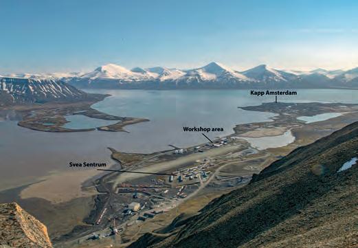
Documentation process
During a five-week timeframe, NIKU employed advanced tools and techniques to conduct the comprehensive documentation project in Sveagruva. With the strategic deployment of three RIEGL 3D laser scanners, five high-resolution DSLR cameras, two camera drones, GNSS and total station equipment, the team meticulously scanned and photographed around 130 buildings and structures. This multifaceted approach employing both laser scanning and photogrammetry methods enabled the detailed capture of physical features and architectural elements.
The documentation process followed a systematic approach for each building. The team established an extensive network of fixed points and reflective targets using land surveying techniques to ensure precise positioning. Laser scanning and photogrammetry techniques were then used for detailed building capture, selected based on factors such as shape, complexity and size.
Erich Nau is a researcher at the Norwegian Institute for Cultural Heritage (NIKU), specializing in 3D documentation and geophysical survey techniques for cultural heritage. With a focus on methodological development, he is passionate about applying these techniques in large-scale projects. He has led successful initiatives in Norway and European countries, contributing to the advancement of cultural heritage documentation. His expertise lies in bridging research and practical application, ensuring that innovative technologies are effectively used for heritage preservation. His work embodies a commitment to the preservation and understanding of our rich cultural past
Bert Azizoglu is CEO of NUBIGON. He and his team provide highperformance point cloud visualization and animation software solutions to laser scanning professionals, surveyors, equipment manufacturers and resellers, along with other stakeholders of the AEC industry involved in reality capture. Since 2018, he has co-led the team developing and distributing the point cloud rendering software NUBIGON which has been used in more than 60 countries. His affection for the outdoors and surveying dates back to his time as a surveyor’s assistant.
Anne-Cathrine Flyen is a Master of Architecture, researcher and PhD candidate in NIKU’s Building Department. Her expertise lies in the field of technical building preservation, with a specific focus on polar cultural environments. She specializes in documenting cultural heritage sites, industrial heritage, environmental monitoring, natural and anthropogenic decay, and heritage management. She has participated in significant national and international research projects and is currently exploring the natural and anthropogenic decay of polar cultural environments in a changing climate.

Issue 6 2023 29 Feature
Figure 2: Sveagruva seen from the Deinbolltoppane mountains. (Courtesy: NIKU)
About the authors
Laser scanning served as the primary method, capturing millions of data points by measuring distances between the scanner and building surfaces. For intricate structures or those with unique architectural features, a combination of laser scanning and photography was employed. Comprehensive visual data was obtained using uncrewed aerial vehicles (UAVs or ‘drones’), photo poles and photographs from various angles. Despite challenges, the team’s expertise and dedication led to remarkable results. The fieldwork generated an extensive dataset, including over 6,000 individual scan positions and 200,000 photographs, totalling approximately 18TB of raw data.

Data processing
During the main processing phase, the RealityCapture software was applied to transform the collected data into high-resolution colourized point clouds. This involved combining laser scans and photographs to create detailed digital representations of each building. Prior to this, a crucial preprocessing step using the RiSCAN PRO software registered, georeferenced and colourized the raw scan data, ensuring precise alignment and positioning. The georeferenced and colourized information seamlessly integrated into RealityCapture, facilitating subsequent processing stages. Multiple photos from different angles were then integrated to densify the models and add realistic texture information, enhancing the highly detailed representations.
In the initial step of the processing workflow, high-resolution mesh models with photographic textures were generated. These mesh models served as the foundation for subsequent filtering and refining. Following that, the mesh models were exported as ultra-high-resolution point clouds, with each vertex representing a single point. The point clouds retained RGB information, preserving colour details captured from the photographs.
Visualization
For the Sveagruva project, NIKU collaborated with NUBIGON Inc., a software company specializing in 3D point cloud rendering. The company developed a customized version of
its software specifically for this project to showcase the rich and detailed digital twin of Sveagruva. The software seamlessly integrates high-resolution point clouds, terrain models, additional 3D objects, text and image annotations, ultimately producing an immersive 3D experience for public engagement. Users can embark on a captivating journey through the mining settlement, exploring its intricate details and gaining an insight into its history.
A custom interface guides users through the digital twin of Sveagruva, providing an intuitive and informative experience with game controllers and a walk-on-terrain mode. High-end 3D visualizations do justice to the site’s historical significance. By leveraging the power of the NUBIGON software and customizing it to the specific needs of the Sveagruva project, the visualizations truly bring the mining settlement to life.

Implications and future display
The visualizations obtained through this comprehensive documentation project have significant implications for the preservation and dissemination of Sveagruva’s heritage.
Issue 6 2023 30
Figure 3: The documentation process included land surveying with total station, image acquisition from a boat to document the old coal loading pier (Gammelkaia), laser scanning on top of the modern coal quay at Kapp Amsterdam, and image acquisition at mine entrances from the 1970s. (Courtesy: NIKU)
Figure 4: Customized user interface and first-person view within the NUBIGON software. (Courtesy: NIKU)
The immersive experiences will be initially showcased in a museum set up on Svalbard, allowing visitors to step back in time and gain a profound understanding of the area’s coal mining legacy. Furthermore, the generated models and underlying data have broader implications. They contribute to the field of cultural heritage management, providing a valuable resource for research, analysis and conservation efforts. The highresolution point clouds and detailed visual representations offer a wealth of information for potential future investigations and studies. Whether for educational purposes, virtual tourism or public awareness campaigns, the digital representations of Sveagruva have the potential to be shared and experienced by people worldwide, fostering a deeper appreciation of the site’s historical significance.


Conclusion
The 3D documentation project at the Sveagruva mining settlement highlights the importance of saving and recording historical sites so that future generations can understand and learn from them. As technology progresses, more opportunities are emerging to discover fascinating stories hidden within the world’s landscapes, and this project showcases the power of today’s
advanced geomatics techniques. Through terrestrial laser scanning and photogrammetry, NIKU has ensured that the history of Sveagruva remains accessible to a wide audience. Thanks to collaborating with NUBIGON, immersive visualizations offer a glimpse into the past, fostering a deeper connection with the region’s industrial heritage.
Today, the extensive environmental project is almost complete, with all manmade structures removed except for the protected oldest traces from the initial mining era. Nature has begun reclaiming the former mining landscape, marking the harmonious integration of nature and history.
Issue 6 2023 31 Feature
Figure 5: 3D view of the Svea Sentrum area within NUBIGON. (Courtesy: NIKU)
Figure 6: 3D view of the loading quay at Kapp Amsterdam within NUBIGON. (Courtesy: NIKU)


GEOMATICS & EXCELLENCE -
Mapping sub-Saharan Africa to enable humanitarian aid
Using AI for good
By Briana Brown, Ecopia AI, USA
Geospatial analysis is a crucial tool for both identifying communities in need and optimizing the distribution of resources. Humanitarian organizations seek to solve some of society’s most complex challenges but, until recently, humanitarian aid workers did not have a reliable source of geospatial data for sub-Saharan Africa. As a result, thousands of people in need were not being reached and the limited resources of nonprofits were not being leveraged efficiently. Thanks to collaboration among the world’s largest humanitarian aid organizations and geospatial data providers, there is now a comprehensive map of every building and road in sub-Saharan Africa. The map is supporting public health, education and sustainability initiatives.
Many people believe the world has already been mapped in its entirety. However, as many geospatial professionals know, despite decades of technological innovation in geographic information systems (GIS), the world is not mapped equitably. While some regions of the world are mapped in extensive detail, including rich context related to land cover or property attributes, others are not.
Developing more equitable maps
Unfortunately, this inequity in mapping tends to affect historically underserved regions the
most. Humanitarian organizations have long been leveraging GIS for field planning and resource allocation, but often struggle with sourcing or creating comprehensive map data for these efforts. While organizations from every industry grapple with the timeconsuming, resource-intensive process of manual digitization or data cleansing, the challenges of data creation and sourcing are particularly difficult for humanitarian aid organizations, which are typically nonprofits with limited resources. Not only are the resources available for these mapping efforts
scarce, but they can also be wasted when inaccurate data is used for field planning. Most importantly, incomplete maps can have dire consequences for those communities not represented.
Underrepresentation
Sub-Saharan Africa is one region historically underrepresented in geospatial data. Until recently, humanitarian organizations active in the area relied on hand-drawn paper maps of settlements and road networks for field planning (Figure 1). Although these maps were better than nothing, humanitarian aid workers knew they were not reaching all communities in need. The paper maps were often outdated and based on approximate locations of settlements. As a result, field teams did not have sufficient information to plan optimal routes between sites or provide the correct amount of supplies.
A group of humanitarian organizations, including the Bill & Melinda Gates Foundation, World Health Organization (WHO) and Centers for Disease Control (CDC), determined they required a reliable map of every building and road in subSaharan Africa to ensure they could reach and adequately serve every settlement in need. This data would allow field teams to locate all settlements in need, estimate the population in different settlements, allocate supplies accordingly and reduce carbon emissions and wasted time from sub-optimal

Issue 6 2023 33 Feature
Figure 1: Hand-drawn map of Maigatari Ward in Sokoto, Nigeria, provided by the Bill & Melinda Gates Foundation and featured in the Netflix docuseries Inside Bill’s Brain
routing between sites. However, geospatial experts estimated that it would take thousands of years to manually digitize the more than 416 million buildings and 17 million linear kilometres of roads in the region.

Mapping communities in need with AI
At first, this astronomical project scope made a comprehensive map of sub-Saharan Africa seem unattainable. Humanitarian organizations held ‘map-a-thons’ to crowdsource manual-digitization help from the international community, but found that even after hundreds of geographers digitized for multiple days, only about a million buildings had been mapped. More formalized mapping projects performed in-house by various humanitarian organizations resulted in buildings from just one country in the region being digitized after a year of work. Therefore, such manual mapping efforts were proven to be unscalable and unsustainable, especially considering the rapidly changing nature of the world in terms of population growth, migration and more. The humanitarian aid organizations realized the need for not only a map of every building and road, but also a way to keep that map up to date.
To generate a comprehensive map of sub-Saharan Africa at scale and also keep it updated to reflect real-world changes, humanitarian organizations turned to artificial intelligence (AI). Having heard about the Canadian mapping company Ecopia AI’s previous work digitizing every building in the USA and Australia in just six months, the organizations engaged the company to digitize every building and road throughout sub-Saharan Africa from imagery provided by Maxar.

Through funding by the Bill & Melinda Gates Foundation and Sustainable Development Technologies Canada (SDTC), Ecopia was able to extract all 416 million buildings and 17 million linear kilometres of roads in just eight months (Figure 2). Because Ecopia’s AI-based mapping systems digitize features with the accuracy of a trained GIS professional, the resulting data serves as a digital source of truth for teams to leverage during field planning and resource allocation. Furthermore, data can be updated efficiently and frequently, meaning maps can reflect population and landscape changes that impact humanitarian operations.
Thanks to the comprehensive map, humanitarian aid organizations have identified thousands of people in settlements not previously represented in geospatial data, and are now providing lifesaving healthcare as well as other essential services to these chronically underserved

populations. Additionally, field teams can now plan the most optimal routes between sites to reduce harmful carbon emissions and preserve scarce resources.
Saving lives and building a more sustainable future
To enable even more teams than those originally involved to leverage this unprecedented map of sub-Saharan Africa, Ecopia established the ‘Digitize Africa’ programme. Since creating Digitize Africa, Ecopia has provided the data to a wide range of global nonprofits for public health, education and green infrastructure projects.
Issue 6 2023 34
Figure 2: A map of every building in subSaharan Africa, digitized in just eight months using AI-based mapping systems.
Figure 3: Building footprints and roads in Ethiopia, created by Ecopia AI.
For example, the WHO leverages Digitize Africa data for the distribution of bed nets to reduce cases of malaria, catchment analysis of Ebola spread, and site selection for snake-bite treatment centres. Many humanitarian organizations are similarly applying the data to improve public health in the region, including the Bill & Melinda Gates Foundation, Red Cross and CDC.
With a digital source of truth for buildings and roads in the region, humanitarian organizations can not only enhance their response efforts following a crisis, but can also help to mitigate future crises by predicting needs and planning field operations accordingly. Unlike settlement centroids, which are only helpful for generally locating a community, building footprints enable population estimations that inform demand forecasting and supply chain management. Additionally, building footprints help field teams locate even the most remote dwellings, rather than just those near a settlement centroid (Figure 3).

As teams continue to work with the Digitize Africa data, geospatial literacy is improving within both the humanitarian sector and the region as a whole. Organizations and individuals alike are recognizing the usefulness of GIS and geospatial data for a wide range of applications, and local teams are building important skillsets to continue advancing the operations on the ground.
This improved geospatial literacy is driving continued innovation in the region. Moving forward, the numerous organizations involved in the Digitize Africa project are looking to expand the use of the data to build out green infrastructure in subSaharan Africa by identifying suitable sites for solar panel installation and other renewable energy sources. Similarly, recent advancements in 3D mapping are improving population estimation models for important initiatives related to education and public health (Figures 4 and 5).
Conclusion
Despite sub-Saharan Africa’s historical underrepresentation in geospatial data, humanitarian aid organizations now have a digital source of truth for planning lifesaving field operations. Thanks to AI-based mapping systems and a network of global partner organizations, the Digitize Africa project


to joining
worked in various GIS-related roles at SafeGraph, Precisely and Esri. She has also volunteered her GIS and data expertise with the United Nations and Catholic Relief Services. She holds a master’s degree in GIS from Penn State University and a bachelor’s degree in Geography from Villanova University, USA.

provides a comprehensive, accurate and up-to-date map of every building and road in the region. With this critical foundational data, these organizations are making a real difference in people’s lives through public health, education and sustainability initiatives, while also improving geospatial literacy and driving innovation in sub-Saharan Africa.

Issue 6 2023 35 Feature
ecopiatech.com/africa
Briana Brown is director of content & product marketing at Ecopia AI. Prior
Ecopia, she
More information
About the author
Figure 4: A sample of population estimations, healthcare facility locations and school locations in Zambia, created by nonprofit GRID3 using Digitize Africa data.
Figure 5: A sample of 3D building data in Kigali, Rwanda, created by Ecopia AI.
Unwavering integrity in an increasingly complex digital continuum
The changing role of the surveyor
 By Chris Trevillian, Director Product Management, Trimble Geospatial
Deeply rooted in the complex history of human progress, the geospatial profession has played an essential role in the underpinnings of equitable and efficient land delineation and infrastructure development over millennia. The essential nature of the surveyor – to provide integrity in the mapping and representation of the physical world and to physically deliver design information back to the surface of our Earth – is largely unchanged since the beginnings of our profession.
However, the demands of today’s world are asking us to adapt our skills in dynamic and important ways. The complexity of our projects continues to grow, while the requests to improve efficiency resound louder than ever. It is up to us to embrace the changing tools as they become available and expand the integrity of information exchange across a wider swath of industry stakeholders.
Actionable, assured intel
Not that long ago, our profession required large survey parties and significant amounts of time and skill to analyse measurements and convert them into detailed maps and actionable information. Today, many projects require professional licensed surveyors to deploy in distinct phases: early phase to feed the design, middle phase for design translation/layout, and late stage for validation to ensure the quality of the built infrastructure.
Today’s advanced geospatial instrumentation allows for complex physical measurements of radio signals from space, or from light signals reflected off nearby prisms or surfaces, to be instantly digitized and seamlessly integrated with other information sources to paint a more comprehensive, near-real-time view of the world. Instrument
sophistication continues to move toward higher levels of traceability, improving overall data quality by systematically eliminating random measurement errors and ensuring data integrity at the point of capture.
Unlocking more of the potential
We are finally unlocking more of the potential from solutions such as mobile Lidar and aerial photogrammetry (which generate massive amounts of data in short periods of time) by incorporating new machine learning techniques that help surveyors automatically extract highly detailed information out of these complex datasets. It is truly incredible how quickly massive amounts of data can be processed and analysed by the geospatial professional in today’s world. This is an important macro trend at a time in history when many in our profession around the world are struggling to retain quality talent. These changes are allowing the survey professional to focus less effort on data quality assurance and more on the underlying information integrity for project stakeholders.
As these physical data capture techniques and digital modelling capabilities skyrocket in sophistication and reliability, we are also seeing the plan, design and build continuum become increasingly digitized at a faster pace. Paper plans are seen less frequently, and high-paced design changes with seamless data interoperability are becoming a requirement across large development projects to ensure project efficiency. We are starting to see large ‘paperless’ infrastructure projects come to completion – and this will be more the rule rather than the exception not too long from now.
Accountability
Since the profession’s inception, the surveyor’s fundamental role has remained unchanged: preserving mapping integrity, representing the physical world, and delivering design information to Earth’s surface.
(Image courtesy: Trimble)
The need for accountability to project, governmental and societal stakeholders is growing, as society is increasingly concerned with the unnecessary waste and the resulting negative environmental impact of projects. In these increasingly complex physical-to-digital and digital-to-physical transformations, there is no space for errors or project rework. The surveyor’s role must transcend the data capture/ process/analyse model. It must move towards a comprehensive, highintegrity, real-time 4D project model that will expedite accountability and critical decision-making while accurately documenting project progress and design changes throughout the entire lifecycle.
Issue 6 2023 36
Adaptability
As we move towards the future, surveyors must continue to adapt to the increasing speed of innovation and market dynamics. As products, platforms and processes continue to evolve, so too must our workflows. Instead of moving people and data from one place to another, we’ll need to learn to move information – and thus decisions –more quickly. Recent advancements in artificial intelligence (AI) and machine learning (ML) rightfully receive a lot of media attention, and the geospatial profession will eventually apply these techniques to field capture systems, including geospatial Internet of Things (IoT) sensors that enable a more dynamic and real-time view of the digital construction process. These same technologies will undoubtedly enhance workflows and continue to eliminate user errors, further streamlining our professional efficiencies.
Artificial intelligence

I believe that AI will be a critical enabler at the seam of physical-todigital transformation across the myriad industries that surveyors serve. Just imagine a network of autonomous geospatial IoT sensors processing data on the edge and feeding real-time clash detection information identified by ML/AI back to project stakeholders, only to have a construction AI toolset redesign the building information modelling (BIM) on the fly based on lowest rework cost and project timeline impact. I honestly believe this reality is closer than most of us realize.

About the author
Chris Trevillian currently serves as director product management at Trimble Geospatial. Prior to his career at Trimble, he worked as a field survey manager. Trevillian holds a BSc in Integrated Science and Technology from James Madison University, Harrisonburg, Virginia, USA.


For our future’s most complex projects to deliver on time and under budget, the surveyor’s expertise in quality assurance will need to infiltrate all aspects of the construction continuum. That infiltration will occur not only in discrete data types or project steps, but will integrate deeply into the real-time models and measurement systems required to dynamically map the changing environment during a project lifecycle. Our essence hasn’t changed, yet our professionals will be asked to evolve from geospatial data managers into geospatial information managers who translate our physical reality into a high-integrity and dynamic digital representation of that reality across a much broader range of stakeholders.


Issue 6 2023 37 Perspectives
SONOBOT 5


• Accurate georeferenced bathymetry and cartography missions, search and survey in hard-to-reach areas
• Autonomous and remotely-controlled operation
• Data logging and real-time acquisition over redundant mesh network


• Exchangeable battery packs for 9+ hours of operation
• System software for planning, execution and data evaluation
• High-precision measurements and recordings, different GNSS and sonar options available


• Rapid system deployment, excellent maneuverability and area coverage with powerful and efficient drives

sales@evologics.de sales-us@evologics.com
OBJECT RECOGNITION


• objects of interest are detected and highlighted live


• AI-based system as an extra module that runs directly

New MULTIBEAM SONAR for the Sonobot 5 vehicle available now!

EvoLogics.de


Geospatial satellite startup NUVIEW on an ambitious mission
Aiming to revolutionize Earth observation with Lidar-based mapping
By Wim van Wegen, GIM International
A new and ambitious startup called NUVIEW entered the geospatial satellite industry in May 2023, following a lengthy period in ‘stealth mode’. In this exclusive interview with GIM International, the company’s CEO and co-founder Clint Graumann discusses the firm’s aspirations. The startup is on a mission to revolutionize Earth observation by constructing the world’s first-ever commercial Lidar satellite constellation dedicated to annually mapping the entire land surface of the planet in 3D and developing intricate virtual replicas or ‘digital twins’. This ambitious endeavour signifies NUVIEW’s commitment to leveraging cutting-edge technology to provide comprehensive and high-resolution geospatial data that will empower multiple critical sectors – such as agriculture, urban planning and disaster mitigation – and drive impact and innovation across the globe.

How did NUVIEW come about, and what are the driving forces behind your groundbreaking plan?
We envision a future with an unparalleled wealth of precise, highresolution data of the Earth’s surface. In a nutshell, I would say that we aim to revolutionize the market by executing our bold vision to create a network of cutting-edge satellites that will provide a continuously updated global 3D point cloud from space. Our company emerged from a deep understanding and recognition of the limitations of traditional Earth observation and mapping methods. Leveraging our extensive experience, we have assembled a team of exceptional professionals and are developing first-of-its-kind technology.
How many satellites will be necessary, what level of resolution are you aiming for, and what is the intended timeframe?
We aim to have 20 satellites in the NUVIEW constellation, and we are building our system with the target of achieving the US Geological Survey’s Topographic Data Quality Levels, beginning with QL2 and progressing over time. As things currently stand, the intention is to launch our satellites in four separate groups. Each group will comprise five satellites, and there will be an 18-month interval between the launch of each group. As a tentative timeline, we plan to launch the first satellites in 24-36 months’ time.
What has been the market reaction to NUVIEW?
Word spreads quickly within the geospatial/mapping community, and our groundbreaking technology created a buzz among people who have been waiting for these advancements. As news of our innovative technology circulated, we began receiving inquiries from numerous groups interested in working with us. These initial contacts paved the
way for strong relationships, ultimately leading to letters of intent, early-adopter agreements and other contracts totalling US$1.2 billion from a wide range of commercial and public entities. And we’re strategically positioned to unveil more fundraising initiatives in the weeks to come.
Interview Issue 6 2023 39
Clint Graumann, CEO and co-founder. (Image courtesy: NUVIEW)
Famous investor from Hollywood
A consortium of investors participating in the project includes a Hollywood star. “We are excited to share the news of our partnership with actor and environmentalist Leonardo DiCaprio as a new investor in NUVIEW. His investment is vital in helping us address global environmental challenges. With his support, we can work towards revolutionizing how we uncover new data and insights to enable more informed decisionmaking among climate scientists, policymakers and conservationists,” stated Clint Graumann.
“NUVIEW’s cutting-edge technology will set itself apart by generating high-resolution, 3D images of the Earth’s surface, aiming to improve our ability to monitor and protect the planet with much more accuracy,” commented DiCaprio in a statement, explaining his decision to invest in what he described as an “unprecedented dataset” for climate science.

According to your website, the data from your prestigious project is set to “elevate global capabilities and transform what is possible for mankind to know about the Earth”. How exactly?
I think it is safe to say that our transformative technology will successfully address current limitations on resolution, accuracy and the ability to penetrate through darkness or dense vegetation. With 20 satellites in orbit, equipped with our advanced Lidar technology, we will provide a continuously updated global 3D point cloud from space. This data will offer invaluable insights to address some of the most challenging scientific, environmental and commercial problems of our time.
How does your company differ from the Earth Archive initiative – another project that aims to map the entire planet in 3D and create a digital twin of the Earth?

While both NUVIEW and the Earth Archive initiative do indeed aim to map the entire planet in 3D, our transformative technology will
address the previously mentioned limitations. Additionally, our constellation of Lidar satellites will provide an annually updated source of high-resolution and accurate data about the whole world rather than being an archive of baseline data.

How is your journey progressing towards achieving your ambitious mission?
NUVIEW has already built a solid position in the market thanks to our impressive level of early-adopter agreements. But that’s not
Issue 6 2023 40
NUVIEW aims to establish the foremost commercial satellite constellation, dedicated to annually mapping the entire land surface of the planet, utilizing advanced Lidar technology. (Image courtesy: NUVIEW)
GEOINT 2023, where he observed the industry’s rapid integration of AI in the geospatial field. (Image courtesy: NUVIEW/Twitter)
all – we have also raised US$15 million during our ongoing Series A round. This funding success can be attributed to the support of prominent investors who believe in our vision. Notable names like Leonardo DiCaprio, MaC Venture Capital, Broom Ventures, Cortado, Florida Funders, Industrious, Liquid2 and Veto Capital have all enthusiastically contributed to our growth. Furthermore, we have assembled an exceptional team of individuals who bring unparalleled expertise, including Nicole Stott, a retired astronaut, who serves as our esteemed advisor; Dr Paul McManamon, a brilliant mind, leading the way as our chief science officer; Dr Jesse Eyer, a visionary in engineering, assuming the role of chief engineer & mission director; and last but not least, Jack Hild, an esteemed USGS senior advisor, who brings invaluable insights to our strategic decisions. With our strong financial backing, unwavering support from influential investors and partners, and this team of remarkable talent as an integral part of our journey, I firmly believe that our company is on the verge of reshaping the industry landscape and propelling it to new heights of success.
What will be the next steps towards realizing your goal? And what are the main challenges?
We’re planning to launch a ‘Space Proof of Concept’ satellite, called ‘Mr. Spoc’ for short, in a little more than two years. This will keep us on track towards launching our first set of satellites within the next 24-36 months, in line with our tentative timeline. In terms of challenges, many issues we face are shared across the tech and innovation communities. However, some challenges are unique to launching and maintaining Lidar-equipped satellites. The Lidar currently used for mapping the Earth is done with unscalable and expensive platforms like aircraft and drones. Therefore, our focus is on developing the most cost-effective, miniaturized Lidar systems to integrate into our satellites. We will also keep our satellites functioning for the long run through rigorous testing and maintenance. NUVIEW’s technology is significant in enabling the entire Earth to be mapped once a year. Additionally, ensuring the longevity of our shared space environment necessitates mindful operation and thoughtful design of satellite systems. This is a challenge that will only grow as the industry continues to expand its activities in space.
Clint Graumann is CEO and co-founder of NUVIEW. An accomplished serial entrepreneur and with a career spanning over 15 years in the Earth observation industry, he has held key executive positions in several renowned companies. This included playing a leading role at TerraMetric, an enterprise development agency specializing in aerospace technology and geospatial applications. Graumann is an alumnus of Oklahoma State University, where he earned a Bachelor of Science degree.
Equipped with advanced Lidar technology, he satellites will provide a continuously updated global 3D point cloud from space.

Which technological developments have helped to make your global Lidar system economically feasible?
The technological advancements in laser capabilities and satellite bus power generation have been key. But other major contributors have been the downward pressure on launch costs, the standardization of satellite buses, and cloud-based data processing. Most importantly, in my view, is that we have patent-pending technology around steering and data collection. That makes a huge difference in terms of scaling Lidar collection globally.
In the longer term, how do you plan to collaborate with partners to expand the range of applications for your global Lidar mapping satellite constellation? We are keen to support the innovation trend based on collaboration and accessibility with open-data policies for researchers, governments and private entities, while protecting against privacy concerns and potential misuse.
How do you envision the future benefits?
I believe that Lidar technology has immense potential to empower global climate initiatives and contribute to a sustainable future. Through our high-resolution and accurate data, NUVIEW can assist in projects spanning urban planning, land use management, environmental monitoring, disaster response and agriculture, all helping to solve some of Earth’s most pressing problems. Therefore, we aim to continue growing our technology and showcasing its impactful applications. Moreover, this community is filled with innovators driving positive change in our world. Hopefully, our breakthroughs will inspire young scientists and attract new talent to the geospatial industry.
Interview Issue 6 2023 41
About Clint Graumann


A project in Angola
How UAV Lidar improves landmine clearance planning
 By Gert Riemersma, Katherine James and Pedro Pacheco
British mine-clearance charity The HALO Trust partnered with Routescene to undertake a UAV Lidar project in Cuito Cuanavale, in the Angolan province of Cuando Cubango. This case study demonstrates the benefits of UAV Lidar to detect and map minefield features as the basis for informing clearance planning. The results can make clearance efforts safer and can expedite clearance through a targeted approach.
Land mines indiscriminately maim and kill countless animals and as many as 5,000 people annually, rendering habitats inaccessible and unusable, and destroying lives and livelihoods. At least 60 states and territories around the world are contaminated by landmines, whether due to the legacy of the past or as the consequence of recent or ongoing conflicts, such as in Ukraine and other areas. Clearance is a painstakingly slow and expensive process and there is a clear need to accelerate landmine clearance across the world.
In Angola, the landmines are a remnant of the civil war that lasted from 1975 until 2002. The province of Cuando Cubango (Figure 1) saw
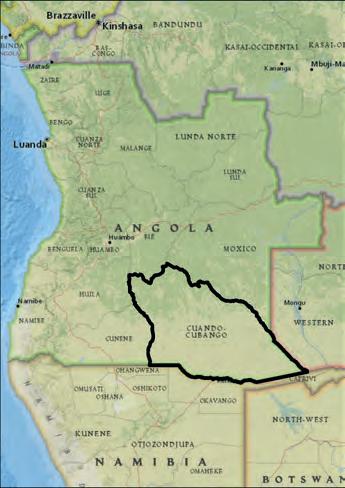
some of the heaviest fighting, and the Battle of Cuito Cuanavale was the largest conflict of the war. Throughout the conflict, there was extensive mine laying by both sides, resulting in multiple minefield sites. Many of them are 20-30km long, including mixed-threat mine belts of anti-vehicle (AV) and anti-personnel (AP) mines which continue to pose a deadly threat to the local community (Figure 2).
To support the clearance operations that began in Cuito Cuanavale in 2005, The HALO Trust trialled the use of remote sensing using uncrewed aerial vehicles (UAVs or
‘drones’) including thermal infrared (TIR) and RGB cameras to identify unexploded ordnance (UXO). However, many indicators of conflict which would suggest the presence of AV and AP mines – such as trenches, bunkers or craters – are now overgrown with vegetation and are no longer visible from the ground or the air using UAV-mounted RGB or TIR sensors. Therefore, another method of detection was needed. UAV Lidar was identified as a possible solution thanks to its ability to penetrate vegetation and enable the survey team to map an area and predict where a mine line may be located.
Issue 6 2023 43 Feature
Figure 1: Map showing the location of Cuando Cubango, Angola.
Figure 2: An anti-personnel landmine laid on top of an anti-vehicle mine.
Initial validation in Scotland
Routescene, a manufacturer of UAV Lidar systems and software, and The HALO Trust, both headquartered in Scotland, first performed a test locally in 2020 to confirm that UAV Lidar could effectively map battlefield remains which would be identifiable in the post-processing software. A suitably vegetated site was found and a replica crater was dug to represent the conditions found in Angola. The simulated crater was easily identified in the resulting digital terrain model (DTM) (Figure 3). This validated that UAV Lidar would be capable of locating and mapping battlefield remains in Angola.
Equipment and software
A demonstration UAV Lidar system was constructed for this project comprising a 16-channel Lidar sensor capable of collecting approximately 600,000 points per second, a GNSS/INS sensor, and data storage to capture 12 hours of data. The system was designed to be resistant to in-flight vibrations and handling by users, and did not require a mobile or internet connection to operate, thus providing operational autonomy and data security. GNSS data was collected for the post-processing of the trajectory to ensure the data was as accurate as possible. The UAV Lidar system was mounted onto a hexacopter capable of lifting a 5kg payload for approximately 15 minutes (Figure 4).

The Angolan project
The aim of the survey project was to detect battlefield features including main trenches, communication trenches, foxholes (one-
man defensive positions), shell scrapes (shallow excavations allowing soldiers to shield from shell bursts and small arms fire) and craters from detonations. Three sites with known or suspected battlefield features were chosen for the Angolan project:

• Site A: an abandoned military base outside of Longa village, 100km northwest of Cuito Cuanavale
• Site B: an extensive defensive mine line with an associated trench, 9km east of Cuito Cuanavale
• Site C: an abandoned military base, 25km southeast of Cuito Cuanavale.
The terrain across the three sites was similar in terms of elevation, all being relatively flat. However, the degree of vegetation coverage varied considerably. Sites A and C had dense tree coverage, whereas Site B had light tree and shrub coverage.
Data collection challenges
At Sites A and B, Lidar data was collected at 40m above ground level (AGL), with one day of collection being sufficient for each site. At Site C, data was collected over three days and at

Issue 6 2023 44
Figure 3: A point cloud, stripped of vegetation using LidarViewer Pro, showing the simulated mine crater.
Figure 5: The survey team were restricted to using the cleared narrow roads for setting up their survey equipment.
50m AGL. This higher altitude was due to the size of the area and time limitations. Moreover, Sites A and B were surveyed during the dry season (August 2021) when vegetation cover was at its lowest. Site C was surveyed during the rainy season (April 2022) when vegetation cover was at its highest.
Practical challenges included a shortage of suitable drone take-off and landing sites and difficulties in siting the base station. At Sites A and B, breach lanes and cleared land were available near the areas of interest. In contrast, Site C was limited by the surrounding uncleared
Gert Riemersma, Routescene
founder and chief technical officer (CTO), is a technical innovator who has worked with Lidar since 2008 and with UAV Lidar since 2013. A land and hydrographic surveyor, he specializes in the development of 3D mapping systems and software, converting technically challenging problems into practical products.

Katherine James, a remote sensing specialist at The HALO Trust, is specialized in the use of UAVs for assisting in the removal of landmines and other unexploded ordnance in countries and territories affected by conflict. Additionally, she is responsible for implementing the deployment of small drones for supporting non-technical surveys.

Pedro Pacheco is a GIS officer and drone pilot for The HALO Trust. Based in Angola, he concentrates on the use of drone surveys for non-technical survey support to aid clearance planning. He graduated from Agostinho University with a bachelor’s degree in Geography, with a focus on satellite image processing and geospatial information technology.

data was analysed to identify the locations of craters from mine detonations, often caused by animal accidents and wildfires, to indicate the location of the mine line. The analysis of DTMs created from the Lidar data showed positive results for the use of UAV Lidar for battlefield feature detection across all three locations.

terrain which contained mines and potentially endangered the survey team. Therefore, the cleared narrow sandy roads were used both as the drone take-off and landing sites and to site the base station. This meant that the equipment sometimes needed to be moved to let vehicles past (Figure 5).
Results per site
The raw Lidar datasets were processed using Routescene’s LidarViewer Pro software to create and export DTMs from each of the sites for analysis in ArcGIS Pro. In areas where there were large gaps in the mine lines or a sharp change in direction, the UAV Lidar
• Site A: Satellite imagery at Site A showed little evidence of the historical military base. An access path was visible, but it was not possible to identify other features. Due to a lack of safe access, only a partial UAV Lidar survey was completed. Nevertheless, when the UAV Lidar data was overlaid onto satellite imagery, multiple features became apparent. The predominant feature was the defensive main trench around the former base, with a communications trench branching off the northwestern internal side of the main trench (Figure 6). In total, 40m of communication trenches and 496m of main trench were identified.
A further 24 feature points were identified: ten foxholes follow the inside of the main trench dug as defensive positions; nine crater-like features clustered inside the base, with two further north near the communications trench (these are suspected shell scrapes); and a line of six crater-like features outside the main trench (unlikely to
Issue 6 2023 45 Feature
About the authors
Figure 6: DTM showing the predominant battlefield feature types at Site A. (Sources: Esri, DigitalGlobe, GeoEye, i-cubed, USDA FSA, USGS, AEX, Getmapping, Aerogrid, IGN, IGP, swisstopo and the GIS user community)
Remote sensing is complementary to conventional minefield survey techniques as it provides information that is not obtainable by any other means
be AV mines as none were found at this location, so these may be shell scrapes). The feature types were confirmed with a ground mission where accessibility and vegetation coverage allowed. The average depth and width of the foxholes (0.58m and 2.36m respectively) and the suspected shell scrapes (0.77m and 2.38m respectively) were similar, suggesting these are the same
type of feature. However, the suspected shell scrapes were identified as a separate feature due to not being in the typical location and pattern of foxholes.
• Site B: Due to thick vegetation and lack of safe access at this site, it was difficult to see what remained of the trench system during field visits. The lighter vegetation coverage at
Site B meant that there was slight evidence of the main trench remains in the satellite imagery. However, other features were not visible. Analysis of the UAV Lidar data identified multiple features including a larger extent of the main trench, communication trenches, foxholes and suspected craters (Figure 7).


In total, 500m of main trench and 281m of communication trenches were identified, alongside 34 foxholes and two suspected craters (possibly from exploded ordnance but unlikely to be from AV mines). The suspected craters were in an uncleared area so it was not possible to access them to confirm their exact nature. The suspected craters averaged 5.85m in width and 0.65m in depth, and the foxholes averaged 0.67m in depth and 2.54m in width. Whilst the majority of the tracks were visible in the satellite imagery, the UAV Lidar data revealed additional historical tracks. This information was used to identify locations of possible safe access roads to the site.
• Site C: This site showed evidence of AP mine laying within the previous military base and was suspected to have at least a single trench and multiple foxholes. However, due to the dense vegetation, it was not possible to identify the locations of the suspected battlefield features from satellite imagery nor from the ground. The UAV Lidar data showed evidence of two trench systems surrounding the former base as well as communication trenches (Figure 8). The data evidenced 157 craterlike features which follow both trench lines, believed to be foxholes due to their regular spacing in close proximity to the trench lines. The data also highlighted gaps in the trench systems which could be explained by the infill of soil levelling out the ground within the trench over time, or rainwater lying in the trench preventing the Lidar pulses from reaching the bottom. Although the trench data was incomplete, the continuation of foxholes between the two extents of the inner trench suggests that the trench once continued to create a circular inner trench system. Overall, 1,429m of main trench (828m on the outer trench and 601m of inner trench), 73m of communication trench and 157 foxholes were identified at this site. The foxholes averaged 0.80m in depth and 2.81m in width.
Issue 6 2023 46
Figure 7: DTM showing the predominant battlefield feature types at Site B. (Sources: Esri, DigitalGlobe, GeoEye, i-cubed, USDA FSA, USGS, AEX, Getmapping, Aerogrid, IGN, IGP, swisstopo and the GIS user community)
Figure 8: DTM showing the predominant battlefield feature types at Site C. (Sources: Esri, DigitalGlobe, GeoEye, i-cubed, USDA FSA, USGS, AEX, Getmapping, Aerogrid, IGN, IGP, swisstopo and the GIS user community)
Conclusion

Remote sensing is complementary to conventional minefield survey techniques as it provides information that is not obtainable by any other means. Within The HALO Trust’s mine clearance operations in Angola, the UAV Lidar data outputs – combined with contextual knowledge on the ground – provided valuable information to supplement conventional survey operations. At all the sites surveyed, the UAV Lidar data provided evidence of trenches, craters and foxholes – features that were either not detectable or only partially visible in satellite imagery, RGB/TIR imagery or from the ground. Therefore, this project demonstrates that UAV Lidar can be used successfully to detect battlefield features that may be indicators of minelaying, particularly when those battlefield features are hidden by vegetation. That evidence can then be used to create targeted clearance plans, making clearance efforts faster and safer.
Acknowledgements
The HALO Trust would like to thank the anonymous private donor for their extremely generous support for the UAV trials in Angola and their commitment to innovation in mine action; this project would not have been possible without their help. Thanks also to go to Routescene for providing the UAV Lidar system, software training and ongoing support since 2020. Last but not least, thanks to Claire Lovelace and Siân McGee from The HALO Trust Angola programme for their ongoing support, both in the field and during data analysis.
Further reading
Landmine Monitor 2022, http://www.the-monitor.org/en-gb/ reports/2022/landmine-monitor-2022/major-findings.aspx
J. Pearce, Control, politics and identity in the Angolan Civil War, African Affairs, Vol. 111, No. 444 (2012).
G. Mills and D. Williams, 7 Battles that Shaped South Africa, 2010, Tafelberg
J. Fardoulis, X. Depreytere and J. Guthrie, Proof: How TIR imaging can locate buried cluster munitions in the Iraqi Desert, The Journal of Conventional Weapons Destruction, Vol. 25, No. 3 (2022).
J. Fardoulis, X. Depreytere, P. Gallien, K. Djouri, B. Abourahmane and E. Sauvage, Proof: How small drones can find buried landmines in the desert using airborne IR thermography, The Journal of Conventional Weapons Destruction, Vol. 24, No. 2 (2020).
D. Shaughnessy, Some thoughts about Private Harold L. Green of the Scout Platoon, First Battalion, the Royal Hamilton Light Infantry, Canadian Military History, Vol 10. No. 1 (2001).
Issue 6 2023 47 Feature
Looking ahead to Intergeo 2023

Berlin gears up for geospatial excellence
As the host city of Intergeo 2023 this October, Berlin promises to deliver the perfect kick-start for the geospatial industry in these rapidly changing times. The vibrant German capital is renowned for its innovating and entrepreneurial spirit, and the event itself is being held in Berlin’s biggest and most modern venue, Hub27. Earth observation, unmanned systems and BIM have been selected as the three key themes for this year’s conference and exhibition. One thing’s for sure: there will definitely be no shortage of inspiration for Intergeo’s national and international participants!
Intergeo will make its highly-anticipated return to Berlin, Germany’s vibrant capital, from 10 to 12 October. Renowned for its innovation, dynamism, unconventionality and entrepreneurial spirit, Berlin ranks among Europe’s top start-up destinations alongside

London. Moreover, with groundbreaking ‘smart city’ solutions, advanced BIM applications and the growing use of drones in mobility and data collection, Intergeo 2023 serves as a laboratory, marketplace and showcase all rolled into one. And this year,
the event will take place in a new area of the city’s exhibition grounds: Hub27, a large and ultra-modern conference and exhibition venue that opened in the summer of 2019, located under the iconic Radio Tower.
Earth observation, unmanned systems and BIM
The three central themes at Intergeo 2023 will be Earth observation (EO), unmanned systems and building information modelling (BIM). Each theme will be supported with a dedicated area of the exhibition hall where attendees can explore the latest developments.
The EO area will provide a platform for businesses, organizations and individuals to learn about the latest EO technologies and applications, including how EO data can be used to monitor a wide range of environmental and socioeconomic phenomena such as climate change, deforestation and urban development. The EO area will feature a variety of activities, including exhibitions from leading EO companies and organizations, conference sessions on the latest EO trends and technologies in the Forum, networking opportunities with other EO professionals, and opportunities to explore potential business opportunities.
The unmanned systems area will showcase the latest developments and applications of unmanned systems in the air, in the
Issue 6 2023 48
The newest addition to the Messe Berlin exhibition grounds: Hub27.
water and on the ground. Geospatial information plays a pivotal role in empowering unmanned systems to navigate and sense their environment, leading to more effective mission planning and obstacle avoidance. Besides exploring the first-rate offerings in the exhibition area, visitors will have the opportunity to attend presentations on workflows, missions and added value in the dedicated conference area. A particular highlight of the event will be the practical demonstrations of these missions and their immense potential.
The BIM area at Intergeo 2023 will be presented in collaboration with BIM-TAGEN Germany. Surveying and geodesy play a crucial role in the BIM process, providing the essential groundwork for modelling construction and infrastructure projects. Before construction work can commence, it is necessary to survey and map the area to gain accurate data about the terrain, existing buildings and infrastructure. This data is then integrated into BIM software for precise 3D modelling. At Intergeo 2023, exhibitors and visitors can discover the very latest BIM trends and innovations, and engage in discussions with industry experts. The BIM area will showcase a wide array of solutions covering the entire BIM process, from planning and design to construction, maintenance and operation of construction and infrastructure projects.
International event with a broad spectrum
Even more so than previous editions, Intergeo 2023 is set to be the premier international event for professionals involved in any aspect of geodesy, geoinformation or land management thanks to its invigorating exploration of such a broad spectrum of topics – ranging from data capture to the advanced applications built on that data, and every step of the workflows in between.
Exhibitors will be displaying their latest solutions based on cuttingedge technologies for surveying and mapping, including satellite and aerial imaging technology, geoinformation systems and spatial data infrastructure. Both on stage and at exhibitors’ booths, experts will be sharing their insights. The start-up area will hum with entrepreneurial energy, while the flight zone showcases the awe-inspiring capabilities of drones and other aerial solutions.
Renowned as a platform for international speakers and thought leaders, the conference will feature enlightening discussions on diverse subjects, including smart cities, digital twins, high-precision positioning, smart mapping and valuation in addition to the special themes of EO, BIM and unmanned systems. Sustainability has long been an important topic at Intergeo, and this year’s edition is no exception. There will once again be a strong focus on how satellite and sensor technology can help to monitor, observe and safeguard our plant in the light of global environmental and climate challenges.
Embracing the spirit of collaboration as always, Intergeo 2023 will foster connections among attendees by providing numerous networking opportunities for start-ups, students, executives and decision-makers from user industries to explore potential synergies together. With its focus on knowledge sharing, exploration and professional camaraderie, Intergeo 2023 in Berlin is an unmissable opportunity for geospatial professionals from around the world to gain innovative insights and broaden their horizons.
GIM International has been an important media partner of Intergeo for many years, so needless to say our team will be out in full force at this unmissable geospatial industry event! Intergeo 2023 is not only the ideal place for our editorial team to uncover the latest trends and gain a sense of what’s in the pipeline, but it is also the ultimate opportunity for our sales team to meet their clients and contacts.

If you are exhibiting at Intergeo 2023 and would like to work with us to gain extra visibility before and during the event, we have various options that could help you. Feel free to contact Myrthe van der Schuit (myrthe.van.der.schuit@geomares.nl) to discuss the promotional opportunities!

Issue 6 2023 49 Feature
GIM International at Intergeo 2023
The centre of Berlin at dusk, with the Fernsehturm in the background.
Map of Intergeo 2023.
Mid-term symposia of ISPRS Technical Commissions

The International Society for Photogrammetry and Remote Sensing (ISPRS) is devoted to the development of international cooperation for the advancement of knowledge, research, development, education and training in the photogrammetry, remote sensing and spatial information sciences, their integration and applications, to contribute to the well-being of humanity and the sustainability of the environment. One of the paths to achieving the above goals is to convene international congresses, symposia and other meetings, with lectures, discussions and – as appropriate – tutorials, exhibitions, technical visits and social events. The publication of the research results from these meetings in The International Archives of the Photogrammetry, Remote Sensing and Spatial Information Sciences and The ISPRS Annals of the Photogrammetry, Remote Sensing and Spatial Information Sciences ensures wide international circulation and additionally records the scientific history of the ISPRS.

Organized by each ISPRS Technical Commission, the mid-term symposia are the most important events in the even-numbered years between congresses. Their themes are related to the field of the respective commission and supported by a diversity of cuttingedge topics. Each symposium provides a unique opportunity for the participants to meet highly distinguished scientists, practitioners, engineers, pioneers and leaders in the field to discuss recent research breakthroughs, technical advances, existing opportunities and emerging technologies. For the term 2022-2026, the mid-term symposia will take place in 2024. Details for each symposium can be found below.

Overview of the mid-term symposia in 2024
TC I: Sensor Systems
Intelligent Sensing and Remote Sensing Application
Date & place: 13-17 May 2024, Changsha, China
Website: www.isprs2024tc1.net
TC II: Photogrammetry
Photogrammetry at the age of AI / AR
Date & place: 11-14 June 2024, Las Vegas, USA
Website: https://u.osu.edu/tc2symposium/
TC III: Remote Sensing
Remote Sensing
Date & place: 4-8 November 2024, Belem, Brazil
Website: https://selperbrasil.org.br/evento/simposio-da-comissao-iiida-isprs-belem-para-brasil/
TC IV: Spatial Information Science
Spatial Information to Empower the Metaverse
Date & place: 22-25 October 2024, Perth, Australia
Website: www.isprs.org/tc4-symposium2024/index.html
TC V: Education and Outreach
Insight to Foresight via Geospatial Technologies
Date & place: 6-8 August 2024, Clark City, Philippines
Website: under construction
50 Issue 6 2023
More information
https://www.isprs.org/calendar/default.aspx
Focusing on True Performance
• Extended Reflectorless range: About 1000m


• Quicker measurement time: Less than 1 second


• Longer operation time: About 50 hours with dual/hot-swap batteries

Positioning System G2U


• Powerful GNSS engine compatible with all GNSS systems: GPS, GLONASS, Galileo, Beidou and QZSS.


• Integrated battery for easy power charge via USB cable.


• Compact, light-weighted and robust housing.
• Intergated tilt compensation function. •


Station V-100N Series V-101N I V-102N I V-102NL (V-101N,
V-102NL TI Asahi Co., Ltd. International Sales Department 4-3-4 Ueno Iwatsuki-Ku, Saitama-Shi Saitama, 339-0073 Japan www.pentaxsurveying.com/en/ Tel.: +81-48-793-0118 E-mail: International@tiasahi.com
Total
V-102N)
The
and
to
New New
design
specifications of the products are subject
change without notice.


