What our latest survey says about the sector’s future
The geospatial shift: Which trends are transforming the industry?
The surveyor shortfall: safeguarding tomorrow’s workforce today
Tackling climate challenges with a collective voice
Thriving startups: driving innovation and progress
Everything you need in GIS software
Lidar & 3D point cloud classification, feature extraction, and analysis
Photogrammetric analysis of UAV/drone imagery
Advanced geospatial analysis tools for a multitude of GIS workflows
Read/write support for over 300 file formats
Workflow automation through Python and Global Mapper scripting
Director Strategy & Business Development
Durk Haarsma
Financial Director Meine van der Bijl
Technical Editor Huibert-Jan Lekkerkerk
Contributing Editors Dr Rohan Bennett, Frédérique Coumans, Lars Langhorst
Head of Content Wim van Wegen
Copy Editor Lynn Radford, Englishproof.nl
Marketing Advisors Peter Tapken, Sandro Steunebrink, Myrthe van der Schuit
Circulation Manager Adrian Holland
Design Persmanager, The Hague
GIM International, one of the worldwide leading magazines in the geospatial industry, is published five times per year by Geomares. The magazine and related website and newsletter provide topical overviews and reports on the latest news, trends and developments in geomatics all around the world. GIM International is orientated towards a professional and managerial readership, those leading decision making, and has a worldwide circulation.
Subscriptions
GIM International is available five times per year on a subscription basis. Geospatial professionals can subscribe at any time via https://www.gim-international.com/subscribe/ print. Subscriptions will be automatically renewed upon expiry, unless Geomares receives written notification of cancellation at least 60 days before expiry date.
Advertisements
Information about advertising and deadlines are available in the media planner. For more information please contact our marketing advisor: myrthe.van.der.schuit@geomares.nl.
Editorial Contributions
All material submitted to Geomares and relating to GIM International will be treated as unconditionally assigned for publication under copyright subject to the editor’s unrestricted right to edit and offer editorial comment. Geomares assumes no responsibility for unsolicited material or for the accuracy of information thus received. Geomares assumes, in addition, no obligation to return material if not explicitly requested. Contributions must be sent for the attention of the head of content: wim.van.wegen@geomares.nl.
This report, based on analysis of GIM International’s 2025 geospatial industry survey, takes a step back to examine the longer-term trends, providing a clearer view of where the industry is heading and giving insight into mapping and surveying professionals’ visions of the future.
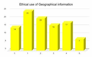
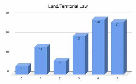
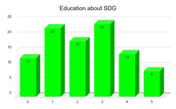
Understanding the status of academic education in land surveying and geomatics has become essential. A recent global survey has provided insight into the curricula, goals, methodology and relevance of the various disciplines taught academically within this field.
In this exclusive interview, Shirley Chapunza highlights the importance of young surveyors to the future of the profession, and outlines how the FIG Young Surveyors Network (FIG YSN) is inspiring, supporting and empowering them around the world.
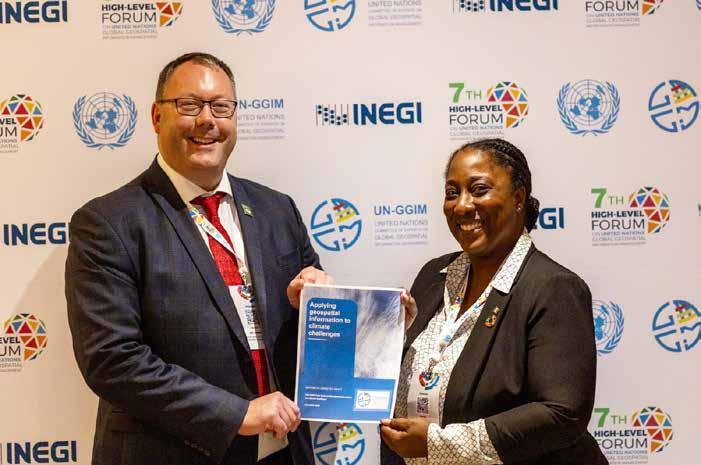
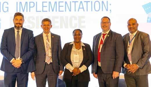
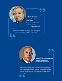
While we can have a positive impact in tackling the climate change crisis as individuals, collectively our voice becomes even more powerful. Policymakers, decisiontakers, activists and champions all have roles to play. A new report highlights the critical importance of geospatial information.
The geospatial industry is evolving rapidly with the infusion of new technologies, but at the same time is struggling to attract talent to certain professional roles. Recognizing the importance of engaging the next generation, the EAASI launched its Young Ambassador Program.
From harnessing high-end technology to navigating the complexities of business growth, startups are driving digital transformation across the geospatial landscape. Throughout this GIM International Business Guide, we shine the spotlight on three pioneering geospatial companies.
We asked representatives from leading industry associations for their views on the key developments and challenges shaping the future. Here, they discuss how emerging technologies and innovative geospatial entrepreneurs can accelerate positive change.
During Peter Parslow’s term as chair of ISO/TC 211, the committee celebrated 30 years of developing and maintaining standards for the geospatial community. In this conversation with him, he reflects on the key milestones in the past three decades.
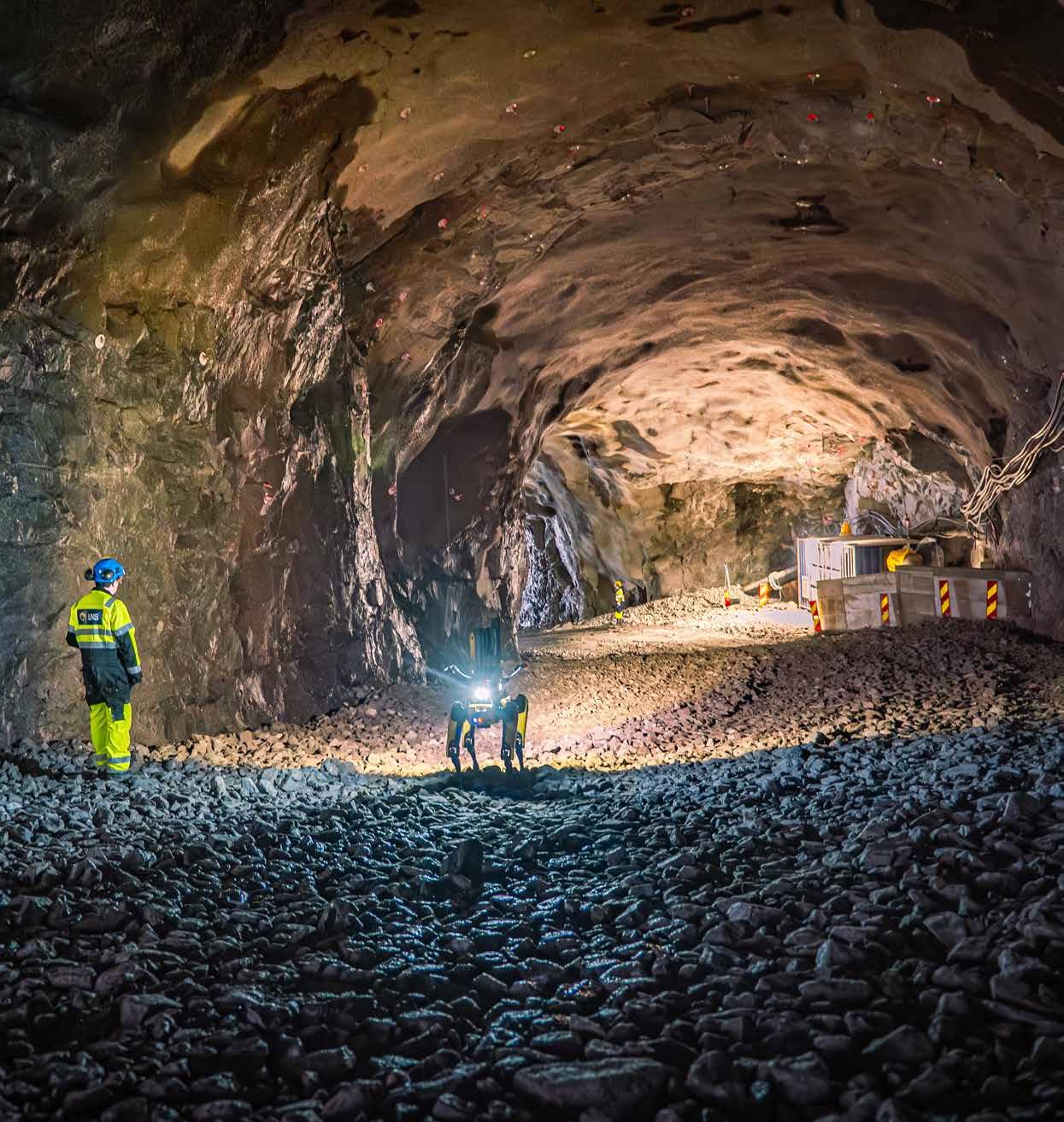
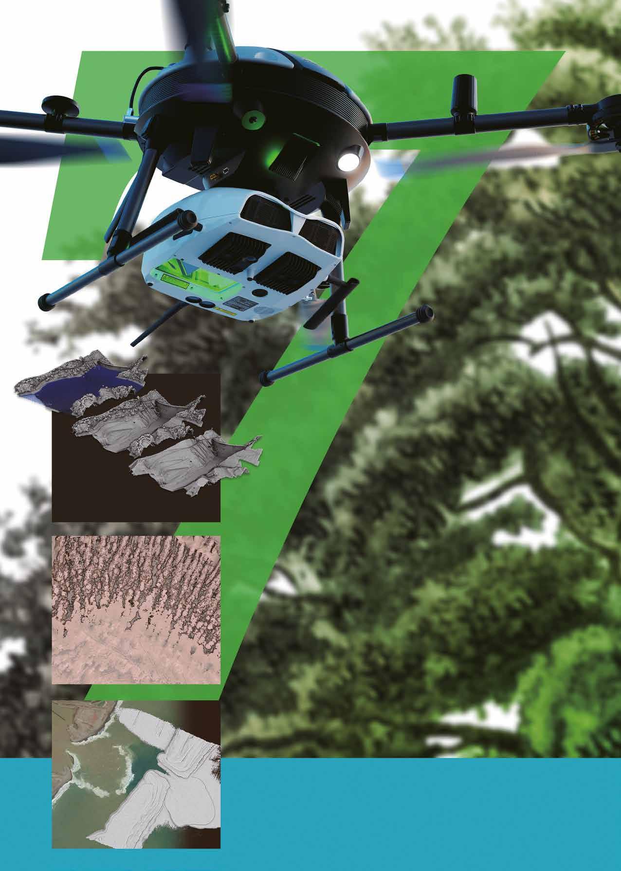
Pictured on the front cover: Spot the robotic dog from Boston Dynamics, equipped with a Trimble X7 laser scanner to capture geospatial data. This GIM International Business Guide 2025 provides in-depth insights into the trends that are transforming the industry. One such trend is the rapid advancement of technology which, while opening up tremendous opportunities for mapping and surveying professionals, also brings certain challenges. (Image courtesy: BuildingPoint Scandinavia/Tomas Jakobsen)
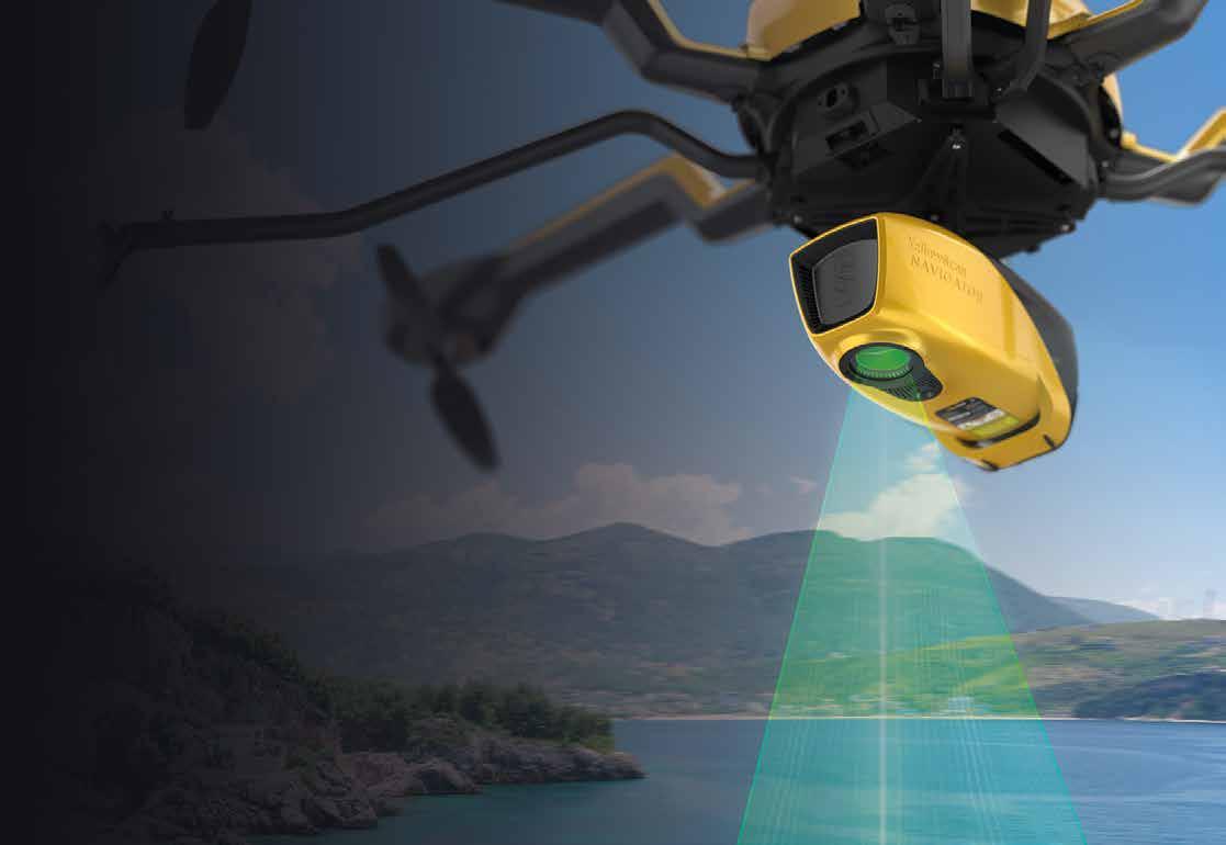
YellowScan Navigator.
An innovative bathymetric LiDAR solution for exploring underwater and ground topography.
Antidote
We are living in an age when the political and economic turmoil in the world seems to dominate the daily life of the global citizen more than ever. Watching the evening news makes one sad these days. ‘Geo’ is at the heart of it all. Think about it: disasters, climate change, economic shifts, migration and war – they are always about ‘where’. In these rough waters of ongoing and rapid changes, being tossed around in our little boat called The World, the annual GIM International Business Guide is a safe haven, sheltered by the breakwaters. GIM International has been around for nearly 40 years, the Business Guide for at least a decade, and the annual readers survey is fast becoming an institution as well. Our head of content, Wim van Wegen, has summarized the findings from the survey as concisely as possible for you (see page 10). The overall mood of the respondents is somewhat less upbeat than in preceding years. Various uncertainties are threatening businesses in different parts of the world – think of tariff wars, deglobalizing economies or natural hazards. Still, I am happy to read that most of the respondents show clear motivation to move forward, to invest in personnel and equipment, and to expand their use of new technologies (which are now also increasingly within reach for those with fewer financial resources). The sector wants to stay ahead of technological developments and build a resilient, futureready workforce. That is reassuring. Because geo is not only at the heart of much of the turmoil that is currently disrupting the world, but is also part of the solution to those same issues. This requires a resilient and determined sector that takes ownership of
its role. In a good example of this, on page 39, James Norris of Ordnance Survey in the United Kingdom issues a rallying cry to put geo to work for the greater good, as laid down in the report ‘Applying Geospatial Information to Climate Challenges’. He calls on us all as members of the geospatial community to become advocates, enablers and agents of urgent response, and to battle climate change together. This echoes the message voiced by Norris, a member of the UN-GGIM Task Team on Geospatial Information for Climate Resilience, during the last United Nations Committee of Experts on Global Geospatial Information Management (UN-GGIM) in Mexico City last October. He urged delegates to take the message home to their respective governments. Another highlight in this Business Guide is the exclusive interview with Shirley Chapunza of the FIG Young Surveyors Network. She leads the younger generation with fervour –inspiring, supporting and empowering them around the world. I would like to conclude this foreword to the 2025 edition of the GIM International Business Guide with an insight from Chapunza, as an antidote to the slightly less optimistic voices about the future outlook and conditions in our industry: the geospatial sector offers all right ingredients for an interesting career, with innovation, cool tech and – last, but surely not least –social impact!
By the way, this Business Guide contains profiles of all our GIM International members. I’d like to say a big thanks to them. With their enduring support, they are contributing to high-quality and in-depth information for many thousands of readers. And you can be sure that these companies are already busy on a day-to-day basis taking ownership of their role, as mentioned above, to make a change for the better!
Amuse oneself Inc
Amuse oneself Inc, established in 2011, develops hardware and software for 3D measurements required for information, communication and robot technology (ICRT).
Since the company successfully commercialized the world’s first Lidar scanner system optimized for drones in 2013, it has continued to improve the accuracy of ICT construction and provide cloud solution services that immediately enable on-site surveying.
Amuse oneself Inc is engaged in a wide range of research and development activities related to the use of industrial drones, and also focused in recent years on establishing technology for safe drone operation and accident prevention, from both the hardware design and education aspects.
EvoLogics is a high-tech enterprise with headquarters in Berlin, Germany, and a US sales office in Yorktown, Virginia. Founded in 2000, the company’s product portfolio focuses on pioneering maritime technologies. Specializing in underwater smart robotics, sensor systems, acoustic communication and positioning networks, EvoLogics integrates advanced engineering with bionic principles. The company’s development strategy centres on an ‘underwater Internet of Things’ for intelligent vehicle and sensor cooperation. Smart underwater networks are built on EvoLogics’ S2C spread-spectrum communication technology that combines underwater acoustic data networks with integrated real-time positioning. The company designs highly capable underwater solutions for complex mission scenarios with advanced sensor systems, AI-based object recognition and analytics, diver navigation systems for interactive mission coordination, and autonomous subsea and surface vehicles for survey and support operations.
EvoLogics evologics.com
+49 30 4679 8620 sales@evologics.com
Blue Marble Geographics
Blue Marble Geographics is a USbased software company offering geospatial tools with a focus on coordinate conversion, point cloud processing and machine-learning.
Blue Marble’s products include: Global Mapper, an all-in-one GIS application with an array of data processing and analysis tools; Global Mapper Pro, a suite of advanced tools for optimizing workflow efficiency, Lidar classification, also generating orthoimages and 3D models from drone-captured images; and Global Mapper Mobile, an app for efficient data viewing and collection while in the field. The company also offers Geographic Calculator, the industry standard for precise spatial data conversion and advanced coordinate system management, now with tools available in the cloud. All these tools are also available as software developer toolkits and libraries. For over three decades, Blue Marble’s products have been trusted by organizations around the globe – including government agencies, universities and Fortune 500 companies.
Blue Marble Geographics bluemarblegeo.com
+1 207 622 4622 info@bluemarblegeo.com
Hexagon AB
Hexagon is the global leader in precision technologies at any scale. Its digital twins, robotics and AI solutions are transforming the industries that shape reality. Hexagon’s Geosystems division provides a comprehensive portfolio of digital solutions that capture, measure and visualize the physical world and enable data-driven transformation across industry ecosystems. The company’s reality-capture technologies create digital worlds from different views, whether a single dimension between two walls in a house, cadastral boundaries of properties, or 3D shapes of cities, infrastructures, utilities, entire countries or even crime scenes. These digital worlds provide actionable information vital for understanding, planning and execution. Hexagon’s Geosystems division includes industry-leading brands such as Leica Geosystems, IDS GeoRadar, Voyansi, LocLab, AGTEK, Xwatch, Bricsys and OxBlue.
NV5 is a global leader providing geospatial solutions, services and software to solve mission-critical challenges.
From data acquisition and analytics to enterprise GIS solutions and software development, NV5 applies geospatial science to deliver end-to-end solutions and insights to mitigate risk, plan for growth, better manage resources, and advance scientific understanding.
The company leverages the widest array of advanced remote sensing technologies and applies today’s most sophisticated analytic AI frameworks, including proprietary deep learning, computer vision and predictive analytic models tailored to clients’ needs. Through off-the-shelf and fully customized solutions, NV5 empowers its clients to enact meaningful change across enterprises, communities and the world.
NV5 nv5geospatialsoftware.com
+1 303 786 9900 geospatialinfo@nv5.com
RIEGL
RIEGL is a leading international provider of cutting-edge airborne, mobile, terrestrial, bathymetric and UAV-based laser scanning technology for a wide range of applications in surveying. In addition to the headquarters in Horn, Austria – where research & development as well as production are located – RIEGL provides sales, support and service through the RIEGL USA headquarters in Winter Garden, Florida, its subsidiaries in Japan, China, Australia, Canada, Great Britain, Hong Kong, Germany and South America, and its worldwide network of distribution partners. RIEGL has been producing Lidar systems commercially for more than 40 years and focuses on pulsed time-of-flight laser radar technology in multiple wavelengths. RIEGL has always been committed to delivering the highest performance, quality, reliability and longevity of all its products and services to perfectly fulfil measurement tasks and fully satisfy the customers’ expectations.
RIEGL riegl.com +43 2982 4211 office@riegl.com
Planet
Planet was founded with the mission to image the Earth every day and make change visible, accessible and actionable. Over the past decade with its customers and partners, Planet has revolutionized the Earth observation industry, democratizing access to satellite data beyond the traditional agriculture and defence sectors. Planet designs, builds and operates the largest Earth observation fleet of imaging satellites and provides mission-critical high-frequency data, advanced insights and software solutions to over 1,000 customers. Businesses, governments and research institutions leverage this living dataset to scale their operations, increase efficiency and mitigate risk, and develop novel solutions to address their most pressing challenges. This allows these organizations to stay ahead in ever-changing global contexts and ultimately capture unforeseen windows of opportunity. Reach out to see how Planet can help you anticipate what’s next.
Meet the UrbanMapper-2 EVO Evolution of Performance
Large Format/3D-Mapping Camera System
450MP ultra-wide nadir channel RGBI (34,500 x 14,100 pix)
Electronically controlled shutter (up to 1/2500 sec) and up to 0,6s triggering rate
Multiple lens configuration
Improved temperature and humidity management
Extended interfacing options and multi-sensor operation ready (e.g. Riegl)
Equipped with:
Robust CCNS-5 FMS
AEROcontrol GNSS/IMU positioning system with anti-jamming solution
Precise leveling technology for gyro-stabilized mount
Find out more at:
sales@igi-systems.com info@igi-systems.com
All eyes on Earth observation
Hundreds of Earth observation (EO) satellites capture images of our planet, day and night. So far, mapping and surveying professionals have been making limited use of the resulting data – but that is soon set to change. Thanks to the remarkable technological progress being made in space, EO has the potential to meet the geospatial sector’s future needs.
When it comes to mapping land use or soil types, satellite imagery is just one of a range of Earth observation possibilities alongside radar, multispectral imagery and Lidar. But in a decade in which the space landscape is rapidly changing, with remarkable progress being made in terms of the satellites continually observing and imaging our planet, Earth observation has the potential to shape the future of the geospatial sector. In fact, I believe that EO deserves more attention than it currently receives – both at the major trade fairs held throughout the year, and also from us at GIM International – in order to keep everyone who uses geoinformation in their work informed about the latest trends and developments. Those developments are moving fast and could lead to unprecedented possibilities for new applications. We just need a little more patience.
Indeed, as Adam Keith – who has worked in the EO sector for over 25 years – wrote in GIM International in 2024: “The [Earth observation] industry probably still needs a couple more years of development and investment before it starts to reach its full potential.” He also pointed out that “if we consider EO’s current position in the growth cycle, apart from a couple of exceptions, I think it is fair to say that the sector is still in the take-up phase. A little perspective is needed.”
So let’s zoom in on EO. To use the words of Adam Keith, there appears to be a kind of ‘chicken and egg’ conundrum. The demand
is clear, and EO companies – both new and established – understand what their future customers need. The challenge now is to turn that insight into action.
For many organizations, EO technology could be a valuable addition to their existing geospatial data toolbox. This is already happening in the hydrographic sector, with the Seabed 2030 project as an inspiring example of Earth observation. Besides various mapping methods, the implementation of satellite-derived bathymetry imagery adds a new dimension to this project, enabling large areas of shallow waters and coastal regions to be covered with minimal investment of time and resources.
Today’s next-generation, high-resolution satellites blend innovative and highly advanced technological power to offer better image quality, spectral bands, imaging capacity and latency than the current fleet. One example is Planet’s Pelican-2 satellite, which was launched successfully in January this year, including the latest NVIDIA GPU processor for AI on the edge and satellite-to-satellite communications. Together, this enables Planet to deliver critical data to its customers in minutes rather than hours.
In the years ahead, as satellite-derived data comes increasingly within reach, ever more organizations will incorporate it when capturing geospatial data about the environment –whether mapping the land or surveying underwater, and whether using terrestrial, mobile, portable, drone-based or airplane-based solutions. Earth observation will increasingly be an important piece of the puzzle for addressing the industry’s growing need for high-resolution, high-fidelity information at scale.
In an attempt to shoulder our responsibility for giving Earth observation the attention it deserves, in this year’s Issue 3 of GIM International we will present the latest developments in advanced satellite imagery, geospatial data and value-added products supporting effective decision-making. The issue will include vivid examples showing the importance and versatility of the EO sector. Feel free to contact us to discuss article submissions or advertising opportunities: wim.van.wegen@geomares.nl
Wim van Wegen Head of content, GIM International
Industry survey reveals ambitions, investment plans and visions for progress
What is top of mind in today’s geospatial sector?
By Wim van Wegen, GIM International
Our industry survey has become an annual tradition, allowing us to assess the development of the geospatial sector. While there may appear to be little change year on year, a broader perspective over a multiyear timespan reveals the technological and societal shifts shaping the industry’s evolution. This report, based on analysis of GIM International’s 2025 geospatial industry survey among hundreds of professionals, takes a step back to examine the longerterm trends, providing a clearer view of where the industry is heading and giving insight into mapping and surveying experts’ visions of the future.
Despite being indispensable across countless aspects of life and business, the geospatial sector has long been overlooked – or at least underestimated – by the outside world. Like the engine beneath the bonnet of a car, geospatial data works in the background, crucially driving numerous processes yet
barely noticed. But the geospatial sector’s technical ingenuity is no longer entirely hidden. As data capturing solutions have advanced and matured over the past years, geospatial data has become more affordable, reaching a wider user group as a result and playing a valuable part in the broader trend
Which technological development has had the most impact on the geospatial industry in the past decade?
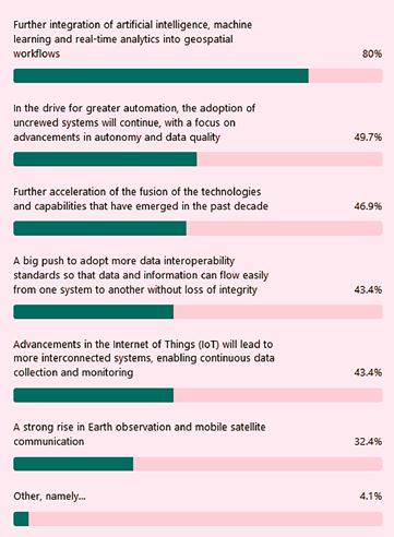
Which emerging trends and technologies do you believe will shape the geospatial industry most significantly in the coming years? (Three choices per survey partipant)
known as Industry 4.0 (and, increasingly, Industry 5.0).
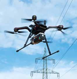
Everyone involved in the mapping and surveying field a decade or so ago remembers the emergence of uncrewed aerial vehicles (UAVs or ‘drones’). Back
What do geospatial professionals see as the biggest challenges for the industry in the coming years?
then, they were welcomed by some as a disruptive change that would open up countless new opportunities, while being labelled by many others as a hype (much like AI today, in fact!). In the years that followed, drones gradually became a standard instrument in the surveyor’s toolkit. In fact, as is usual when an innovation moves into the mainstream, their novelty seemed to have worn off. However, the technical engineering didn’t stand still. Thanks to significant advancements in the area of payloads, such as the miniaturization of sensors, drones started to reappear in the results of last year’s annual survey, and their ‘comeback’ has further intensified this year.
The evolution of Lidar sensors
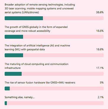
The resurgence of drones in the geospatial sector is closely linked to the broader adoption of remote sensing technologies, particularly in the form of Lidar sensors for UAVs. In this year’s industry survey, 38.6% of respondents identify the widespread use of remote sensing technologies – including 3D laser scanning, mobile mapping systems and drones – as the most impactful development in the past decade. The integration of Lidar sensors has greatly expanded the capability of UAVs, enabling precise aerial collection of high-quality data that has become essential for modern surveying work.
In addition to the rise of remote sensing, other key technological advancements highlighted by the survey include the growth of GNSS technology (named by 18.6% of respondents), the integration of artificial intelligence (AI) and machine learning with geospatial data (18.6%), and the maturation of cloud computing and communication infrastructure (17.1%). These innovations all contribute to a more connected, efficient and accurate geospatial landscape in which drones and their evolving sensor capabilities play a central role.
One of the respondents sums it up very fittingly: “As ever, surveying is being driven by technology. Conventional surveying is being gradually replaced by various forms of remote sensing and scanning. I still use total stations and GNSS, but my employers purchase these services from surveying contractors as and when required.” Another participant comments: “The improvement of the characteristics of laser scanners and the possibility of installation on various mobile platforms has enabled their application in various new areas.”
About the author
AI is a game changer
Wim van Wegen is head of content at GIM International and Hydro International. In his role, he is responsible for the print and online publications of one of the world’s leading geomatics and hydrography trade media brands. He is also a contributor of columns and feature articles, and often interviews renowned experts in the geospatial industry. Van Wegen has a bachelor’s degree in European Studies from the NHL University of Applied Sciences in Leeuwarden, the Netherlands.
Needless to say, there’s no avoiding AI when asked about the development with the most impact on the industry. As one geospatial professional shares: “From my own experience, I’ve seen that artificial intelligence (especially deep learning) has already made a great impact on remote sensing, as it is an excellent help in everything from data acquisition to processing, analysis and interpretation.” According to this expert, the integration of AI into remote sensing significantly enhances data quality, automates data processing, refines feature extraction and classification, facilitates change detection, enables data fusion, and streamlines quality control procedures. These advancements will lead to more accurate, comprehensive and timely analysis and interpretation of remote sensing data.
“By employing AI methods like deep learning, I believe professionals in the field can not only improve the quality of the data they work with, but also extract meaningful insights and automate numerous aspects of data analysis. This approach unlocks the full potential of remote sensing technology for a wide range of applications,” the respondent continues.
In fact, the continued integration of AI, machine learning and realtime analytics into geospatial workflows leads the pack of emerging trends and technologies that will shape the geospatial industry most significantly in the coming years, with no less than 80% of respondents in agreement on this. The high degree of consensus underscores the industry’s strong belief in the transformative potential of these technologies to enhance decision-making, efficiency and automation in geospatial applications.
While the hype of a few years ago has subsided somewhat, AI is still widely regarded as a game changer for analytics in the geospatial domain. “So far, we saw only very specialized tools. This will go into more general applications to open the door for directly moving from sensors towards solutions,” states one professional. Another respondent is more cautious: “AI and automation all sound great, but companies find it hard to invest/keep up with what they can’t understand. And AI can only work to its full potential if it’s ‘good data’ that it’s working from.”
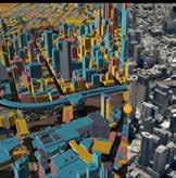
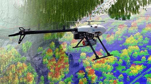
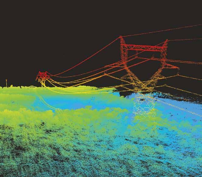
This image from Tetra Tech showcases the progress made in combining UAV and Lidar technology in recent years. Tetra Tech’s holistic approach to gathering, processing, and analysing high-precision survey and mapping data empowers clients to better manage natural resources, enhance strategic planning, and drive informed design and decisionmaking. (Image courtesy: Tetra Tech)
The comments fields where survey participants could explain their answers produced some interesting – and at times highly intelligent! – input, as illustrated by this example: “Today, we have high-quality 3D point clouds that will need to be processed in the coming years using AI/ML algorithms. Additionally, sensor fusion requires calibration through new methods such as wavelets (which analyse data in both time and frequency domains), Fourier transforms (which decompose signals into constituent frequencies), and Legendre polynomials (used for solving differential equations and modelling complex datasets), alongside traditional calibration parameters. All of this needs to be integrated into an automated workflow, which is still a work in progress.”
The drive for automation
The drive for automation is expected to play a central role in the evolution of the industry, making data collection and analysis both more efficient and more reliable. Roughly half of the participants anticipate further adoption of uncrewed systems, for instance, with a particular focus on improving autonomy and data quality. According to one of the experts who completed this year’s survey: “We are now able to collect large amounts of very precise data in a short time. The greatest improvement we expect is the automation of the processing of that data to produce final spatial products and/or decision-making based on them.”
Another conclusion from the survey results is that technology fusion is expected to accelerate further. 46.9% of the respondents regard the integration of capabilities developed in the last decade as a key future trend. This entails advances in remote sensing, sensor fusion and data
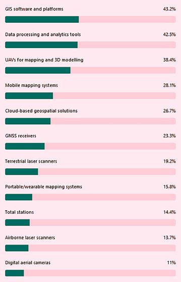
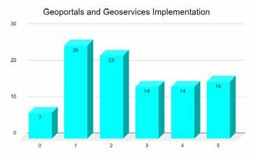
In which solutions do companies/ organizations plan to invest in the coming years?
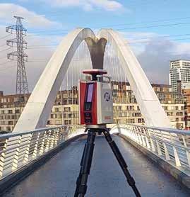
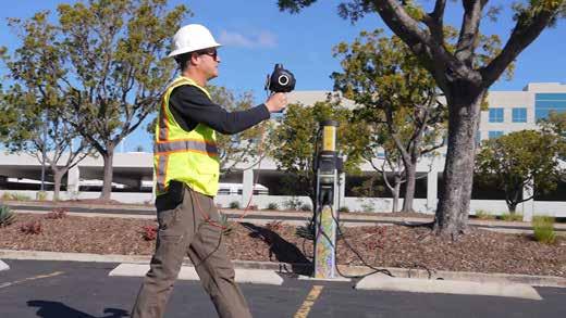
An example of technological advancements in the toolkit for surveyors: close-range photogrammetry with a terrestrial hand-held unit, supported by sophisticated AI algorithms, provides superior spatial resolution, rapid data processing, and visualization and analysis via a web app environment. (Image courtesy: Looq AI)
processing, leading to more sophisticated and versatile solutions. One respondent points out: “As one technology changes, it creates a wave affecting other technologies. We expect even greater things to happen in the future as one aspect of change triggers a chain reaction with other technologies.”
Data interoperability standards and IoT
Besides these technological developments, 43.4% of the respondents highlight the need for more data interoperability standards to ensure seamless data exchange between systems, minimizing integrity loss and enabling smoother integration across platforms. One survey
Besides investing in technologies, companies are clearly aware of the need to address the ongoing shortage of skilled personnel
Which strategies are being implemented to address the shortage of skilled personnel in the geospatial sector?
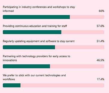
How is your organization adapting to the rapid technological advancements in the geospatial industry?
participant welcomes all the advancements, but underlines the importance of solid geospatial data as the basis: “All the answers point to the fact that data-led decisionmaking, whether it be by humans or AI, is on the up. But nearly everything requires good foundational data. Therefore, things like standards or interoperability will continue to be key.”
Improving data interoperability standards is also highlighted as a priority to optimize workflows. One expert explains: “If we could spend more time analysing and providing solutions rather than manipulating data to fit across tools, the industry could advance at a much faster pace.” Indeed, ensuring the accuracy, consistency and security of geospatial data is vital for delivering reliable insights across various applications. Reflecting the importance of data quality and management, 42.5% of the professionals surveyed highlight the need for improved data handling processes.
Meanwhile, 43.4% of respondents predict that advancements in the Internet of Things (IoT) will facilitate the creation of more interconnected systems for continuous data collection and monitoring. Lastly, 32.4% of professionals envision a strong rise in Earth observation and mobile satellite communication, signalling an ongoing interest in enhancing global monitoring capabilities. Interestingly, the 2025 survey reveals a stronger interest in Earth observation compared to previous editions.
Planning the built environment
Multiple participants foresee that the emerging trends and technologies shaping the geospatial industry will have a profound impact on how we plan and live in the built environment. “As digital twins evolve from individual assets to entire cities and infrastructures, the seamless endless flow of data – from site capture to dynamic modelling and real-time change management – becomes an increasingly achievable goal. This will rely on workflows designed to ensure interoperability across platforms and applications,” comments one. Another respondent states: “The ability to use a unified base dataset across multiple use cases and applications will unlock immense potential, offering great value to society, enabled by the evolving technologies that are transforming the geospatial data workflow.”
On the topic of the geospatial industry’s ability to contribute to tackling societal challenges such as climate change, one participant states: “Ultimately all the benefits of geospatial data, and the analysis possible to aid in reporting and action for the purposes of climate change monitoring and prevention, are done out of principle – there is rarely a business case for it. There has to be a societal shift.”
Talent shortage impacting on quality
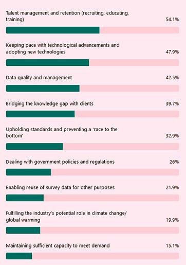
One of the most substantial challenges facing the geospatial industry in the coming years is the shortage of skilled workers. Recruiting, educating and training the next generation of professionals remains a key concern, as illustrated by the fact that talent management and retention once again top the list in the survey (54.1%). Notably, only 14.9% of respondents report that they are not currently experiencing a shortage of skilled personnel.
A considerable number of respondents –especially in the Western world – point out that the popularity of the geospatial discipline seems to be decreasing among today’s young people, who are largely looking to enter professional life on high salaries and with limited effort. “The geospatial science domain requires the professional to be up-to-date in the application of technology, keep their theoretical knowledge fresh and improve the engineering and application experience. Such a difficult business environment loses its attraction to youngsters,” comments one respondent.
Bridging the knowledge gap with clients appears to be another hurdle. Roughly 40% of the respondents have experienced difficulties in effectively communicating complex geospatial concepts to customers who may not necessarily have a deep technical understanding of the field. One respondent from Great Britain sums up both of these issues: “There is a shortage of surveyors in the UK, it seems. This affects capacity to provide services. The knowledge gap with the clients seems to be variable, with some very showing lack of technical understanding.” Similar issues can be found in a vast array of regions and are definitely not limited to the UK alone.
Moreover, 32.9% of the survey participants express concerns when it comes to preventing a ‘race to the bottom’ in terms of
pricing and quality. Upholding high industry standards while staying competitive remains a delicate balance for many professionals in the geospatial sector and can potentially have a stifling effect on business operations. One entry notes: “The industry is slowly getting smaller talent pools. We have many inroads through technological advances that attract people, but they have the IT abilities and unfortunately not the wider geospatial views/ skills. The cheapening of dataset collection does not promote a quality culture and there are still no best/standardized ways for sharing or storing data.”
Keeping pace with innovation
As innovation accelerates, staying up to date with the latest tools and techniques is critical for the sector’s continued growth and relevance. However, 47.9% of respondents say they struggle to keep pace with technological advancements and adopt new technologies. Especially smaller companies are affected by this, but various other factors can have an impact. One of the survey participants zooms in on the challenge in African countries, for example: “Many regions face barriers in implementing these innovations due to infrastructural limitations, budget constraints and resistance to change. Additionally, there is a significant knowledge gap, as most universities tend to produce average users of geospatial tools rather than highly skilled professionals with advanced expertise. This results in a workforce that may struggle to fully leverage emerging technologies.” This underscores the need for different solutions in different parts of the world. Some ways of addressing this, according to the respondent, include “technical training […] as building a highly skilled workforce will be key to unlocking the full potential of the geospatial industry. Bridging these gaps will require targeted educational programmes, ongoing capacitybuilding initiatives, and stronger industryacademia partnerships.”
Investment plans in technologies and talent
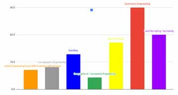
When asked about their plans for technological investments, respondents were allowed to provide multiple answers in this year’s survey. GIS software and platforms are out in front, with 43.2% of respondents planning to invest. This is followed by 42.5% focusing on data processing and analytics tools. UAVs for mapping and 3D modelling
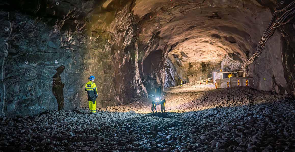
The geospatial industry is in the midst of an exciting transformation. One great illustration of this is Spot the robot dog (from Boston Dynamics), fitted with the Trimble X7 high-speed 3D laser scanner. A surveying professional keeps an eye on the proceedings. (Image courtesy: BuildingPoint Scandinavia/Tomas Jakobsen)
are an investment priority for 38.4%, and also on the radar for many companies are mobile mapping systems (28.1%) and cloud-based geospatial solutions (26.7%). Other areas with investment interest include GNSS receivers (23.3%), terrestrial laser scanners (19.2%) and portable/wearable mapping systems (15.8%), followed by total stations (14.4%), airborne laser scanners (13.7%) and digital aerial cameras (11%). Given the size of the worldwide geospatial industry, even the smaller percentages represent a pretty high volume of potential equipment sales.
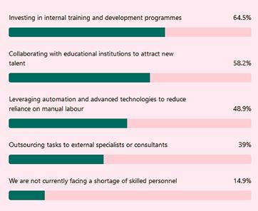
Besides these envisaged technological investments, companies are clearly aware of the need to address the ongoing shortage of skilled personnel, with 64.5% of organizations investing in internal training and development programmes, and 58.2% partnering with educational institutions to attract new talent. Meanwhile, to reduce reliance on manual labour, 48.9% are turning to automation and advanced technologies. Additionally, 39% are outsourcing tasks to specialists.
Visions for progress
To gain insight into the future visions of geospatial experts, this year’s industry survey concluded by asking the participants to name the one thing they would change about the geospatial industry to drive meaningful progress. This question produced a series of interesting and varied responses. One respondent mentions the importance of more lobbying to increase general awareness of the sector’s work, stating: “Raising awareness for the importance of our industry can help bridge the gap between its potential and public recognition.” Another
participant suggests that higher investment in cross-sector education and training is critical: “Increasing geospatial literacy across sectors can empower more professionals and ensure better collaboration.”
Others see the need for better collaboration between surveyors and GIS specialists, advocating for the idea that “this is not an ‘either/ or’ situation”. Improved stakeholder collaboration is also suggested, with one participant stating: “If I had the capacity, I’d ensure that all stakeholders focus on their specialized areas, build human capacity, and maintain high standards.” Lastly, one expert refreshingly highlights the importance of often-overlooked tasks: “Don’t forget to celebrate the ‘boring’ work. Without strong processes, testing and learning from failure, the extraordinary accomplishments in our field wouldn’t be possible.”
Conclusion
Compared with previous editions, the tone of the reactions in the comment fields in this year’s survey is somewhat less upbeat Perhaps the current geopolitical circumstances play a role in this, not to mention the climate-change issue looming over the market. But despite the uncertainties and slightly less optimistic mood, the ambitions of the participants remain strong, with continued intent to invest in new equipment and personnel, and a clear motivation to move forward. With the vast majority of the survey participants painting a picture of increased technological possibilities that have come within reach of more and more professionals in recent years – including those with fewer financial resources – it should be possible to actually realize many of those ambitions. This year’s survey reconfirms the sector’s determination to not only stay ahead of technological advancements, but also to build a resilient, future-ready workforce that can thrive in an ever-evolving landscape. This drive to innovate and adapt, combined with the ‘engine beneath the bonnet’ (i.e. geospatial data) will enable the geospatial industry to continue to offer solutions for the multifaceted challenges that the world faces.
GIM International interviews Shirley Chapunza, chair of FIG Young Surveyors Network
Contributing to the continuity of the geospatial industry
By Lynn Radford, contributing editor, GIM International
In this exclusive interview, Shirley Chapunza highlights the importance of young surveyors to the future of the profession, and outlines how the FIG Young Surveyors Network (FIG YSN) is inspiring, supporting and empowering them around the world. The good news is that the gender balance is improving, with the number female surveyors on the rise, but the industry urgently needs more young people from all backgrounds.
FIG YSN’s mission is to inspire the next generation of surveyors. How is this put into practice?
Our mission is not just to inspire them, but to ‘INSPIRE’ them. This stands for Inspire, Nurture, Strengthen, Promote, Innovate, Raise awareness, and Empower. In everything we do, we reinforce the awareness that, as a young surveyor, you’re contributing to something that’s much bigger than you; your work gives you the chance to leave a legacy of some sort.
We put this into practice by organizing numerous events – meetings, workshops, conferences and training courses – all over the world. We work in partnership with the FIG commissions, FIG foundation and FIG taskforces, and often with leading external associations like the Global Land Tool Network (GLTN), UN-Habitat, World Bank and FAO. Our activities and partnerships help to position the younger generation as the ambassadors and agents of change, and amplify the voices of young surveyors for the benefit of the industry. After all, the future of our planet – our common future – lies in their hands.
The biggest advantage of the YSN is the network itself. Young surveyors don’t only meet their peers, but also gain access to a global community of seasoned experts – and in terms of the learning experience that can’t be traded for anything. At an individual level, we give young surveyors the opportunity to gain international experience and exposure,
helping to prepare them to become future leaders, and we support their personal and professional development through our flagship outreach and development programmes.
Are there any particular FIG YSN activities you are especially looking forward to this year?
I am really looking forward to the second YSN meeting for the Americas region, which is being held in the USA this October. We’re working to overcome the language challenges in the hope of encouraging more Spanish-speaking young surveyors to join us, so that everyone in that region can contribute their voices to the surveying profession. We’re also targeting attendees from the small-island developing states in the Caribbean. We’ve already made contact with a few surveyors there and hope to bring more of them into our network. We want this meeting to be as diverse as possible.
Before that, we’re gearing up for the 9th FIG Young Surveyors Conference in Brisbane, Australia, as a pre-event to the 2025 FIG Working Week and Locate25 – the Australian Annual Surveyors Conference – in early April. Organized in collaboration with the Geospatial Council of Australia Young and Emerging Professionals, this promises to be a very exciting event, truly championing innovation. Based around the theme of ‘Next-gen Geospatial Professionals: Driving a Digitally Enabled Future’, it’s being hosted at one of the world’s largest digital interactive
learning and display spaces: the Cube at Queensland University of Technology’s Science and Engineering Centre.
Since 2017, we’ve chosen to support a different charity during each event. This year, in conjunction with the FIG Commission on Hydrography and the Mapping the Plastic Working Group, we’ve selected an ocean conservation charity. As part of the charity event, we’re planning a geocaching activity with FIG Working Group on Learning Styles in Surveying Education. This is a great opportunity for us to highlight innovation in surveying education as well as showcasing the role that surveyors play in preserving the world’s oceans.
FIG YSN strongly emphasizes empowering communities through the engagement and leadership of young people. Can you share some practical examples?
The Volunteer Community Surveyor Program (VCSP) is a great example. This is our collaborative global outreach programme through which FIG young surveyors volunteer their time and energy to support humanitarian and environmental causes. It was actually started by a young surveyor. Supported by the FIG team in Copenhagen, as well as by the generous donations from our financial partners such as GLTN and Kadaster, and technical partners such as Trimble, young surveyors are deployed wherever they are needed to support mapping efforts.
“Our industry has all the right ingredients to be an interesting career option: you get to use cool tech and make a social impact too”
Projects have included co-organizing mapathons in Tanzania, supporting organizations like OpenStreetMap, and providing training to private surveyors in Sierra Leone where surveying degrees are not available through local universities. These projects enable young surveyors to develop their interpersonal skills as well as their technical skills. They also broaden their horizons by integrating with diverse communities and embracing boundaries and differences. You come back a better professional, and also make a social impact by tangibly improving people’s lives.
To what extent is diversity & inclusion a topic within FIG YSN?
We are intentional about engaging and embracing diversity and being as inclusive as possible. In the past, it was a distinct objective to get more women involved when shaping our event programmes, for example, but that has now simply become an automatic and natural process – it’s part of who we are. Having said that, as a traditionally male-dominated industry, it’s not always an easy task to ensure a gender balance among keynote speakers, for example. The good news is that the demographic is shifting; the number of women in the industry is increasing and there are numerous female role models who will hopefully inspire even more females to join. And within YSN globally, we actually have more female chairs than male chairs.
Diversity is not just about gender, of course, but also about professional backgrounds. FIG has ten commissions covering many different disciplines, so we ensure that every programme we develop is interesting for these diverse groups of people. Moreover, we are keen to include and involve young surveyors in our network from as many different socioeconomic backgrounds as possible. In this context, various sources of sponsorship are available to young surveyors who have limited funds. One example is the FIG Foundation Young Surveyor Grant. Since 2006, this grant has enabled numerous recipients – male and female, from a wide range of countries – to attend events and make their voices heard.
In many parts of the world, the shortage of talented and skilled surveyors entering the job market has become a growing concern. What are today’s young people looking for? I think that many young people are increasingly looking for work that has a purpose and social impact. They care about topics like sustainability, climate action and what is happening in the world around us.
At the same time, today’s youngsters are tech-savvy and are attracted by fast-paced technological developments. In this context, I’ve noticed
that domains such as GIS and remote sensing tend to attract more young people than traditional areas such as cadastral surveying. But if it’s innovation that people are looking for, there’s plenty going on in some of those areas too – just think of how far we’ve come with smart total stations, compared to having to set out points in the past.
But perhaps youngsters would rather spend time in front of a screen than working outside and being exposed to the elements? This actually aligns well with the current evolution of the surveying role. Having traditionally been only data acquirers, as surveyors we increasingly need to also manage and analyse the data we’ve collected and present it to our customers and other stakeholders. This growing need for data management specialists is creating new and appealing roles for the younger generation in the surveying industry.
What can the geospatial industry do to turn the tide and to spark interest among young people in the field of surveying and mapping?
Our industry has all the right ingredients to be an interesting career option. You not only get to use some cool tech, but you can have a social impact too; you can make a real difference for the greater good. But we’re clearly still not packaging this in a way that the younger generation fully understand. Speaking from my own experience, I only ended up in surveying by accident. I actually applied to study mining engineering, but that programme was oversubscribed and I didn’t want to do a gap year, so the admissions officer suggested surveying instead. I knew nothing about it when I started out!
Having said that, there are now some really good things happening to get the message out there. I love Get Kids into Surveying, for example, and how they use fun marketing materials to attract kids’ attention. And perhaps we could all do our bit by being more active on social media to share interesting insights into our working lives.
I also think that academia has a role to play by keeping pace with where the industry is going so that curriculums remain interesting and relevant. Speaking from experience again, I must admit that my degree course was fine, but it didn’t really get exciting until my fourth year when I did my internship. Students shouldn’t have to wait three years for surveying to become interesting!
During your term as chair of FIG YSN, how do you hope to contribute to the continuity of the geospatial industry? For the continuity of the surveying industry, it’s important that all young surveyors have the chance to come together, engage and
Attendees at the 8th FIG Young Surveyors Conference (8FIGYSC) in Accra, Ghana, 2024. (Image courtesy: FIG YSN)
contribute their voices to the profession. But last year, I noticed that not all regions were equally well represented and active within FIG YSN. Therefore, I’m working hard to make the network even more inclusive and diverse by zeroing in on specific countries within the regions, with the aim of establishing new local networks and stimulating more engagement. It’s rewarding to see that this is already paying off. We’ve had some very successful events recently, including in Romania and Nepal, both of which have helped to reinvigorate regions that had become somewhat dormant since the pandemic.
Another focus area for me is our mentoring programme, which I would like to be available to everyone over time. We ‘borrowed’ the concept from Australia’s Surveying and Spatial Sciences Institute (SSSI) (which is now the Geospatial Council of Australia, Ed.), and we have implemented it in Africa, but we’re now keen to expand it to other regions. But we can’t do this alone. We need support from FIG member associations, regional networks, corporate organizations and surveyors themselves so that we can pair mentees with mentors in multiple geographical locations. A spirit of collaboration and partnership will be essential to invest in the future and help
Shirley Chapunza (aged 29) first came into contact with the African arm of FIG YSN when she attended a regional meeting in Botswana as an intern in 2018. She has been chair of the global network since January 2024. Due to internal organizational reasons, her term will run for three years rather than two. She holds a bachelor’s degree in surveying and geomatics from Midlands State University in Zimbabwe. Following a few years as a teaching assistant, Shirley now works as an engineering surveyor at Bitumen World Civil Engineering Contractors company in Zimbabwe, which specializes in road construction, infrastructure development, concrete works and building projects using precast concrete solutions.
us offer this opportunity to as many young surveyors as possible, so that we can keep transferring valuable skills and knowledge to support the continuity of the industry.
Besides this, I am personally very keen to ensure the continuity of FIG by developing a community for former FIG YSN members. Young professionals in their thirties tend to become less active due to other things going on in their lives, such as changing jobs and starting a family. As
they get a little older and things stabilize, they have more time to engage with the community again. But we currently have two distinct groups – young professionals and seasoned professionals – and in your late 30s and early 40s, you might not fully identify with either. So where do you belong? This can leave people feeling a little lost and perhaps even discourage them from getting involved any more. Therefore, by the end of my term, I hope to have created a new
Participants in the 8FIGYSC Leica-sponsored charity event in Accra, Ghana, 2024. (Image courtesy: FIG YSN)
About Shirley Chapunza
platform to account for these ‘mid-career professionals’ too. This will not only help to smoothen the transition after FIG YSN, but will also ensure we don’t end up with a gap between the ‘older’ and the ‘younger’ generation– because if we do, the community could be at risk of just fading away.
Do you have a final message for the surveyors of the future?
Since being involved in FIG, I’ve learned that every societal problem has got a ‘land footprint’. I think the most important thing is that we, as young people, need to stay curious and keep on asking questions. Where have we been? Where are we now? Where are we going? And then think about what we can do individually to make the best possible contribution, professionally, ethically and with integrity. We are solution providers – let’s keep championing new solutions. That way, we can hopefully be part of building a better future – not just for the surveying profession, but for the entire planet and for the people whose livelihoods depend on it.
About the FIG Young Surveyors Network (YSN)
The FIG Young Surveyors Network was established as the Working Group 1.2: Young Surveyors Working Group of FIG Commission 1 at the XXIII FIG Congress (2006) held in Munich, Germany. This was upgraded to the Young Surveyors Network during the 2009 FIG Working Week in Eilat, Israel.
FIG YSN’s goal is to inspire the next generation of surveyors. The purpose is built on three pillars:
• To improve the number of young professionals participating within the FIG, including its 10 commissions.
• To help young professionals in the beginning of their careers with contacts.
• To increase co-operation between the commissions and the students and young professionals network.
The network – which is subdivided into five regional networks for the continents – has created an environment for young surveyors from different cultures, with different academic backgrounds and professional experiences from all over the globe to come together and learn from each other towards the sustenance of the surveying profession. The network is open to young surveyors (surveyors aged 35 years or under, or students of surveying or a related study) and young surveying professionals (graduated less than 10 years ago with a bachelor’s or master’s degree in surveying or a related study).
More information
https://www.fig.net/organisation/networks/ys/
CHC Navigation
CHC Navigation (CHCNAV) develops advanced mapping, navigation and positioning solutions designed to increase productivity and efficiency.
Serving industries such as geospatial, agriculture, construction and autonomy, CHCNAV delivers innovative technologies that empower professionals and drive industry advancement.
With a global presence spanning over 130 countries and a team of more than 1,900 professionals, CHC Navigation is recognized as a leader in the geospatial industry and beyond.
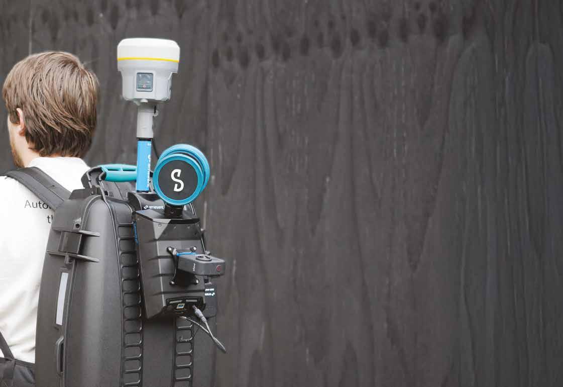
Emesent
Emesent Hovermap represents the gold standard in SLAM-based mobile mapping, specifically designed for challenging and GPSdenied environments. Providing fast, accurate and long-range autonomous scanning, Emesent Hovermap provides powerful insights by mapping the inaccessible while minimizing operational downtime and maximizing worker safety.
Integration of real-time kinematics (RTK) further enhances accuracy where GPS signals are available. Emesent Hovermap intelligently leverages both SLAM and RTK to optimize results, delivering seamlessly georeferenced outdoor to indoor scanning without the need for ground control points.
A range of accessories – including support for 360-degree colourized image capture and deployment via drone, robot, vehicle, backpack and more – offer a solution of unmatched versatility and robustness.
CHC Navigation chcnav.com
+86 21 5426 0273 marketing@chcnav.com Feima
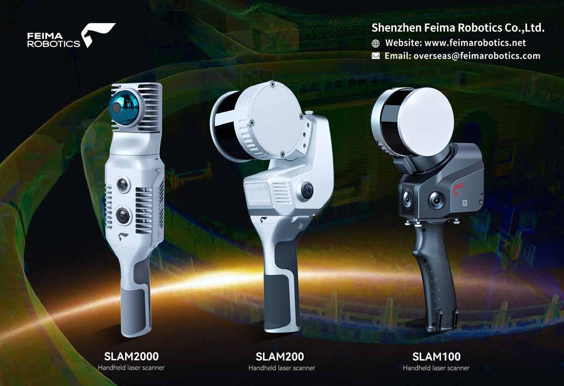
Feima Robotics
Founded in 2015 by senior managers jointly with senior experts in IT and drone technology, Shenzhen Feima Robotics Co, Ltd (Feima Robotics) is a world-leading solution provider for drones and modern geospatial applications. Feima Robotics has R&D centres in Shenzhen, Beijing and Tianjin, totalling more than 200 staff in the research team. With more than 20 years’ accumulation in technology and marketing, and with experience in IT product design and industrial manufacturing, Feima Robotics is dedicated to providing drones and geospatial solutions with integrated software and hardware and a one-stop spatial data system service. So far, Feima Robotics has released about 20 types of intelligent drone systems for aerial survey, remote sensing, patrol, emergency applications and dynamic 3D mobile surveying platforms including handheld SLAM laser scanners and data processing software. Feima Robotics has gained a wide range of users in the world and built up a solid reputation in the industry.
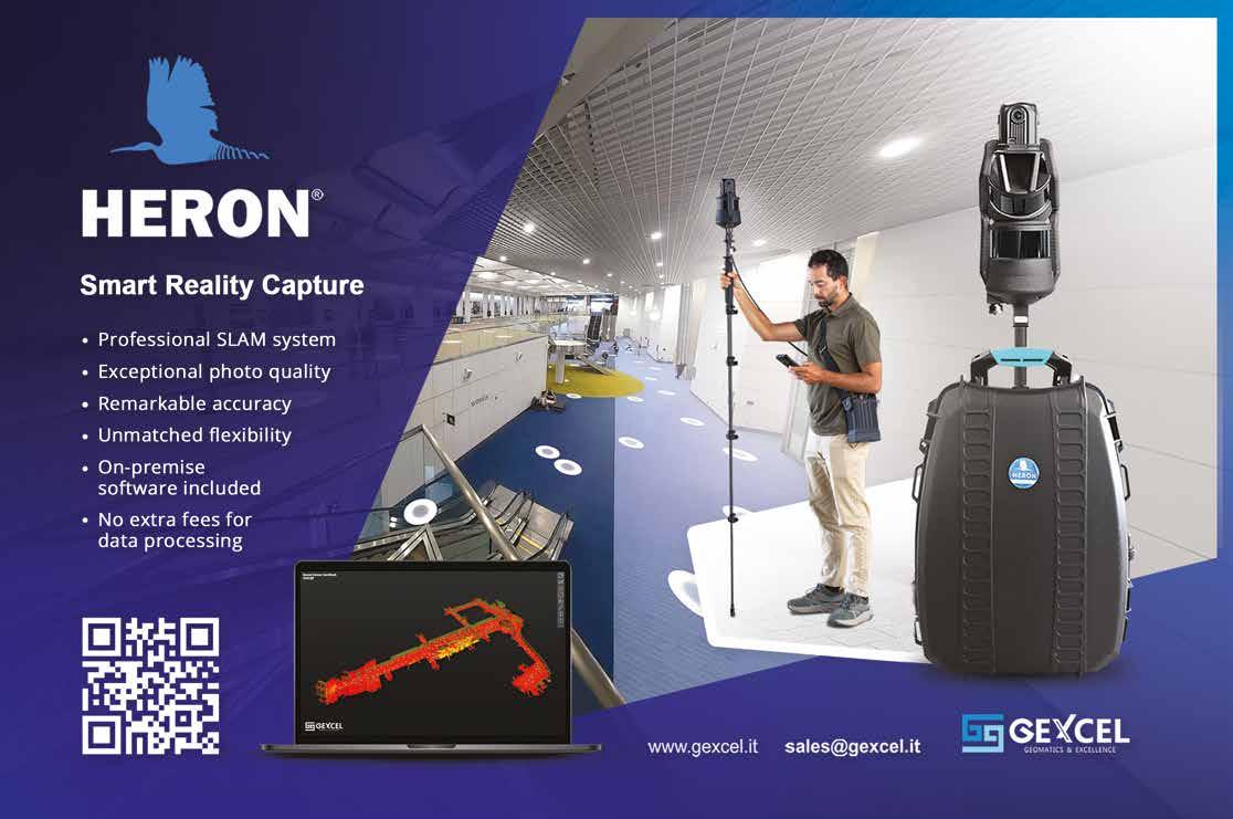
GEXCEL
GEXCEL is a dynamic, independent company with almost two decades of experience as a reliable geospatial and 3D mapping market player. It develops and supplies highly innovative hardware and software solutions for 3D surveying and Lidar data processing. The main goal is to improve the efficiency and effectiveness of geospatial technologies to be true allies in the field. The flagship product, the HERON portable 3D mapping system, exemplifies the company’s commitment to innovation. With its advanced features, HERON enables users to capture accurate 3D data effortlessly, simplifying workflows and achieving superior results. GEXCEL offers support, training and service directly from its offices in Italy and Vietnam, or through its international network of distributors. It collaborates with major market players to ensure product integration and usability. The company actively participates in numerous research and development projects, promoting innovation and contributing to progress in the geospatial sector.
Hi-Target
Established in 1999, Hi-Target is a pioneering high-precision surveying and mapping instrument brand that has achieved a successful listing in China. Hi-Target is committed to investing heavily in research and development and specializes in providing a comprehensive range of integrated commercial solutions for various industries.
IGI
IGI – Integrated Geospatial Innovations – is one of the world’s leading geospatial companies and conducts business worldwide. IGI’s customized concept provides modular but also durable and easy-to-use turnkey solutions, which offer high-end quality in deliverables at the best possible accuracy. This ensures that the company’s clients achieve sustainable and smart geospatial solutions.
The company’s offerings include surveying and engineering solutions, mobile GIS, hydrographic survey solutions, monitoring solutions, machine control solutions, precision agriculture solutions, and global correction services.
With a global workforce of approximately 2,000 employees, Hi-Target boasts a well-established network of 11 operation centres and over 700 partners in more than 100 countries/ regions. This extensive infrastructure enables the company to efficiently serve and support its valued customers worldwide, ensuring they receive the best solutions for their needs.
Hi-Target hi-target.com.cn
+86-20-28688296 sales@hi-target.com.cn
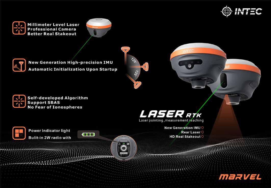
Intec Surveying Technology
Intec Surveying Technology. is a professional enterprise that integrates the development, production, sales and maintenance services of surveying and mapping products. The team is dedicated to the research & development, design and maintenance of surveying and mapping industry products.
For a long time, Guangzhou-based Intec has been adhering to the concept of ‘high-quality, honest management, and enthusiastic service’ in its commitment to providing highquality, reliable and affordable products and services for the surveying and mapping industry.
The company’s success is driven by its people and commitment to achieving results the right way – by operating responsibly, executing with excellence, applying innovative technologies, and seizing new opportunities. IGI’s entrepreneurial focus is on integrating various sensors into its in-house-developed positioning system, as well as providing all-in-one solutions for mobile and airborne surveying missions.
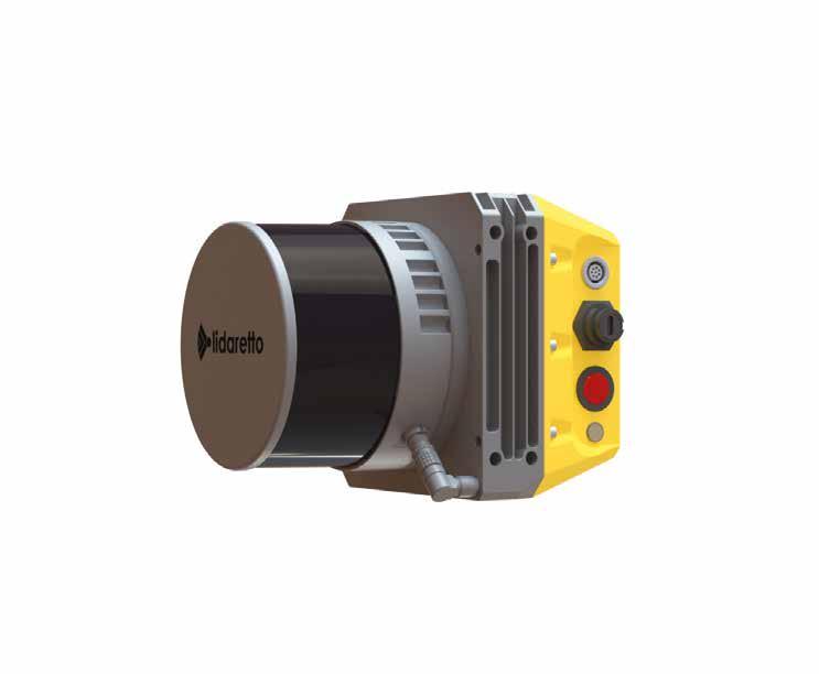
Lidaretto
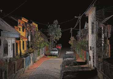
Lidaretto is a flexible and compact Lidar scanning system developed since 2015 and uniquely designed to be used in a way that best fits the user’s specific application. Lidaretto can be easily mounted and swapped between multiple platforms, such as a UAV, car, backpack, bike, train or USV. The highest quality point cloud is ensured by using best available technologies from Lidar and GNSS/IMU manufacturers and Lidaretto’s own state-of-the-art processing algorithms. Lidaretto allows its users to carry out a wide range of operations faster, more comfortably and safer than ever before. Lidaretto’s flexibility means it can be used in many applications in industries where accurate and reliable 3D data needs to be captured. It can be used by surveying or construction companies, foresters, archaeologists or mining crews and for GIS mapping or BIM modelling. Lidaretto can significantly increase the productivity, and therefore the competitiveness, of its owner.
Pythagoras
Pythagoras has been a trusted name in the surveying industry for over 30 years, offering Pythagoras CAD, a dedicated solution designed specifically for surveyors. Trusted by thousands of geoprofessionals worldwide, it seamlessly supports all major data formats and brands, ensuring reliable and accurate results. Now meet Pointorama, the company’s groundbreaking web platform that redefines indoor mapping with point clouds. Traditional methods often require manual tracing and adjustments, leading to inefficiencies and errors. Pointorama changes the game with its plane-based vectorization, automatically detecting walls, floors and structural elements with unmatched accuracy. By leveraging advanced 3D object detection, users can generate precise, ready-to-use vector plans with minimal input. With real-time visualization and an intuitive interface, Pointorama eliminates costly rework, accelerates project timelines, and delivers results you can trust. Discover how Pointorama can revolutionize your workflow.
Pythagoras
pythagoras.net
+32 14 61 32 70 info@pythagoras.net
STEC
STEC is a cutting-edge technology startup founded by a team of visionary tech enthusiasts with 15+ years of career experience, a shared passion for innovation and a drive to provide better products and solutions in the fields of geospatial, civil engineering, agriculture, monitoring and more.
SBG Systems
SBG Systems, a leading provider of navigation technology, presents its latest inertial navigation system: Quanta Plus, for optimized SWaP and stellar performance in harsh environments. Quanta Plus delivers accurate and reliable navigation data even in the most demanding environments. It combines a high-performance miniature tactical IMU with a GNSS receiver that is resilient to harsh covering conditions, providing RTK fixes even in challenging situations (0.015° roll/pitch, 0.04° heading, 1cm positioning in RTK). Additionally, the new Qinertia 4 makes post-processing easy for all surveyors’ projects. SBG Systems’ post-processing software Qinertia gives access to offline RTK corrections from over 10,000 base stations in 164 countries. Trajectory and orientation are then greatly improved by processing inertial data and raw GNSS observables in forward and backward directions. Qinertia 4 is packed with many innovative features, such as the extended CORS network support and Ionoshield PPK mode.
SBG Systems sbg-systems.com/ +33 1 80 88 45 00 sales@sbg-systems.com
Trimble Applanix
We live in a complex and dynamic world. As your business evolves, you need a partner who can adapt with you and help orient your business for success.
STEC’s mission is to empower businesses and individuals by harnessing the full potential of emerging technologies.
The company strives to create innovative, user-centric products and solutions that enhance efficiency, improve productivity and drive progress in accuracy.
STEC stecprecision.com
+86-2082258682 sales@stecprecision.com
Trimble Applanix’s systems, software and solutions are designed for pinpoint accuracy, efficiency and ease of use, supporting applications for mobile mapping, surveying and autonomous vehicles. Like its solutions, the company works for you in all environments, applying deep expertise and passion to customize practical solutions that meet your complex needs, whether on the ground, in the air or on water.
In a dynamic world, trust your position with Applanix.
Trimble Applanix applanix.com
+1 289 695 6000
Trimble GNSS for OEMs
Dedicated to the world’s tomorrow, Trimble is a technology company delivering solutions that enable our customers to work in new ways to measure, build, grow and move goods for a better quality of life. Core technologies in positioning, modelling, connectivity and data analytics connect the digital and physical worlds to improve productivity, quality, safety, transparency and sustainability. Trimble GNSS technology delivers position integrity and localization as it relates to the overall safety and accuracy of operations. With the increase in demand for highquality, reliable positioning, Trimble has developed leading highprecision solutions to ensure the application can operate successfully in all conditions.
Positioning – and so much more: There’s more to solving today’s industry challenges than accuracy alone. Trimble empowers you with customized solutions that work whenever you need them, now and into the future. And makes them easy for anyone to use.
YellowScan
YellowScan designs, develops and builds Lidar solutions for professionals who require performance, robustness and accuracy. Its hardware and software solutions are easy-to-use data collection tools that come with training and support from the company’s experts.
Vexcel Imaging
Renowned for its industry-leading aerial cameras and hybrid cameraLidar mapping solutions, Vexcel Imaging is a global leader in aerial imaging. The UltraCam systems are designed to deliver unmatched flying efficiency combined with exceptional data quality, ensuring best-in-class performance for every application. Outputs include photogrammetric imagery and point clouds, Lidar point clouds and other derived products. The fully integrated UltraMap photogrammetric processing software enhances project workflows with advanced automation, efficient data interaction and intuitive tools, enabling the creation of photogrammetric outputs such as DSMs, DTMs, orthoimages and 3D data of the highest standard. The Vexcel Data Program (VDP) features the world’s largest aerial imagery and geospatial data programme, currently covering 40+ countries. VDP offers eight different products, including Elements for the most up-to-date property and building attributes.
The products include embedded laser scanners, INS, GNSS receivers and onboard computing. Each system is designed to meet the highest precision and accuracy needs for 3D mapping.
Founded in 2012 in the south of France, YellowScan has sales, customer training and support representatives around the globe. The company’s products are used worldwide in surveying, bathymetry, forestry, environmental research, archaeology, civil engineering, mining sectors and more.
Zoller + Fröhlich
Beyond being a leader in the fields of ferrules, wire harnessing technology and laser measurement technology, Zoller + Fröhlich (Z+F) is known worldwide as a manufacturer of innovative products in the areas of switch cabinets and special machinery. All products have been developed and produced exclusively in Germany, where the company employs more than 280 people.
Z+F is an internationally operating company and cooperates with dealers in more than 40 countries. It also has a permanent subsidiary in the USA.
Besides the business success, human beings have always been at the heart of the corporate philosophy. This principle can be seen in the company’s various social and cultural commitments, which always share the objective of regionality and strengthening the company’s locations.
Young ambassadors inspire the future
Bringing fresh perspectives to aerial surveying
By Ada Perello, EAASI
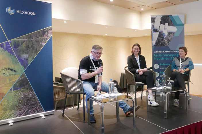
The geospatial industry is evolving rapidly with the infusion of new technologies, but at the same time is struggling to attract talent to certain professional roles. Recognizing the importance of engaging the next generation, the European Association of Aerial Surveying Industries (EAASI) launched its Young Ambassador Program in 2024. During a panel discussion during the most recent EAASI Partners Summit, two young ambassadors shared their perspectives on the sector. The Young Ambassador Program is just one facet of EAASI’s broader initiative to modernize the industry.
Aimed at showcasing the dynamic careers within aerial surveying, the EAASI Young Ambassador Program connects young professionals with industry leaders to foster knowledge-sharing and innovation. By also spreading the word about the aerial surveying roles and career options, the ambassadors themselves contribute to attracting talent to an industry often perceived as ‘old-fashioned’.
At the EAASI Partners Summit in Athens from 19-22 November 2024, two young
ambassadors – Alice Hilton and Charlène Negrello – shared details of their professional journeys and visions for the future of aerial mapping during a panel moderated by Patrik Meixner of Primis. Meixner, an active member of EAASI’s University and Students Committee, highlighted the importance of mentorship and industry-academic collaboration during the session.
Diverse journeys into aerial surveying “When most people think of aerial surveying,
they imagine outdated technology and traditional methods. But the reality couldn’t be more different,” said Alice Hilton, a dynamic product specialist at Bluesky International. Hilton’s journey into the industry reads like the ideal mix of passion and opportunity. While studying at the University of Exeter in the UK, she attended the 2022 Esri Conference in London, where she discovered Bluesky’s National Tree Map. The product perfectly aligned with her dissertation research on tree mapping and climate change, prompting her to reach out to the company. Since joining Bluesky in September 2022, her role has evolved to encompass various environmental products, collaborating across sales and production teams while engaging in vital marketing initiatives to showcase the industry’s impact. She shared her experience during the last EAASI Partners Summit in a blog post.
Charlène Negrello’s path to becoming a project manager at Sixense Helimap tells a different but equally compelling story. Her international journey through geomatics began in France with civil engineering studies. But it was a transformative year in Calgary, Canada, that sparked her passion for geomatics engineering. Six years ago, Negrello found her perfect match at Helimap System (now Sixense Helimap), where she combines technical expertise with her love for international work. “This industry offers something rare – the chance
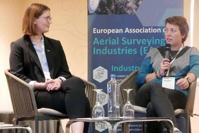
EAASI Young Ambassadors Alice Hilton and Charlène Negrello shared their stories during a panel moderated by Patrik Meixner of Primis at the EAASI Partners Summit in November 2024.
to blend cutting-edge technology with real-world impact while working across global boundaries,” she commented. Her experience demonstrates how aerial surveying can fulfil both professional ambitions and personal aspirations for adventure and innovation.
Engaging young talent with dynamic storytelling
Despite its cutting-edge technology, aerial surveying remains largely underappreciated. Hilton and Negrello concurred that a significant obstacle lies in the limited awareness of the industry among younger generations. “Many are familiar with GIS,” Hilton observed, “but not necessarily with aerial surveying.” They both emphasized that clear and engaging communication is crucial to bridge this gap. Relatable analogies, such as comparing aerial surveying to the familiar interface of Google Maps, can help to effectively explain the sector’s impact. To pique curiosity, Negrello suggested initiating conversations by referring to well-known technologies before delving into technical specifics.
The ambassadors also stressed the importance of early geospatial education, as both believe that cultivating curiosity early on can demystify the industry’s complex roles. “Universities excel at introducing GIS, but awareness needs to begin in primary and secondary schools,” Hilton remarked. Negrello added that integrating geospatial concepts into interactive games could inspire children to explore the field. She proposed gamifying geospatial education to make learning more accessible and enjoyable, such as by simulating real-world mapping missions.
Ultimately, effectively communicating the industry’s contributions to solving contemporary challenges is paramount. As many individuals are driven by a desire to make a positive change, the industry can capitalize on this by highlighting its growing role in environmental monitoring and impact assessment. By showcasing how aerial surveying and geospatial data analysis enable efficient and resource-saving solutions compared to traditional field methods, the industry can demonstrate its alignment with modern
About the young ambassadors
Alice Hilton is product specialist at Bluesky International, having joined the company in September 2022 to work on the National Tree Map as a graduate product specialist. Her role has since expanded to include the development of other environmental products.
Charlène Negrello is project manager at Sixense Helimap and has been with the company for six years. During her studies, both in France and in Canada, she seized every opportunity to gain international experience, including conducting topographic fieldwork in Cameroon and spending a semester in Belgium.
Furthermore, clear communication about career pathways, applications of geospatial data, and the industry’s overall contribution to a better future will be crucial in inspiring and attracting the next generation of professionals.
Technology as a bridge, not a barrier
Their perspectives on technology, particularly artificial intelligence (AI), offered a nuanced view that challenged both techno-optimism and scepticism. “AI isn’t replacing surveyors; it’s empowering us to focus on more complex challenges,” Negrello emphasized. She referred to the growing integration of AI in data processing, while highlighting the irreplaceable human elements of aerial surveying –judgment, adaptability and creative problem-solving.
The ambassadors’ shared vision extends beyond technology to the industry’s culture and community. They explained that they are actively working to create a more inclusive and supportive environment that attracts diverse talent. Through EAASI’s committee meetings, they’ve proposed expanding mentorship programmes and establishing stronger connections with universities. “The key is showing that aerial surveying isn’t just about technical skills,” Hilton noted. “We need creative thinkers, problem solvers and communicators. There’s room for everyone who wants to make a difference.” Negrello added that the industry’s impact on sustainability and urban development makes it particularly appealing to purpose-driven young professionals.
The ambassadors are advocates of a more inclusive and supportive environment within the aerial surveying industry to attract diverse talent and foster a thriving community.
sustainability goals.
A complete suite of precise positioning solutions that exceed your farthest goals
Centimeter-Level Positioning Accuracy, Anywhere
With local RTK base stations, VRS networks and Trimble’s worldwide CenterPoint® RTX correction service via satellite or cellular/IP
Longer Product Life Cycles
Durable, completely supported future-proof solutions that last as you grow
Precise, Consistent Performance
Trimble ProPoint® GNSS technology leverages all constellations and frequencies with tight INS integration and sensor fusion to deliver unparalleled performance under challenging environments
Global Support Get expert help through the entire lifecycle, wherever you are
Flexible Integration
Scalable technology platforms for the full autonomy stack and faster go-to-market implementation
Quddus Busari won the inaugural
crucial connections between academia and the next generation of spatial professionals.
Modernizing the industry
The Young Ambassador Program represents just one facet of EAASI’s broader initiative to modernize the industry. Working closely with the University and Students Committee, led by Board Member Simon Musäus, the organization has launched several projects. One of EAASI’s flagship programmes is the ‘Spatial Business Bridge’ Outstanding Thesis Award, which encourages postgraduate students to explore the intersection of geospatial technology and business applications. Quddus Busari was the winner of the inaugural award with his master’s thesis on ‘Building and validating AI machine learning algorithms for tree structure characterisation from highresolution aerial images and Lidar data,’ presented at the University of Leicester, UK.
EAASI has also launched educational webinars highlighting diverse career opportunities within the industry, featuring professionals sharing their experiences and insights. Since 2022, the organization has sponsored the International Geodetic Student Meeting (IGSM), supporting knowledge exchange and networking among geodesy students worldwide.
A bright future for aerial surveying
Despite these initiatives, challenges persist in talent attraction and retention. The rapid pace of technological advancement requires continuous evolution in education and professional development approaches. However, these challenges present opportunities as the industry increasingly integrates with artificial intelligence, big data analytics and smart city technologies, opening new avenues for innovation and career development. Through organizations like EAASI and their initiatives, the industry can illuminate career paths for future innovators, ensuring continued growth and meaningful contributions to our understanding and management of the world around us.
About the author
Ada Perello is the communications manager of the European Association of Aerial Surveying Industries (EAASI). She holds a master’s in Communication and a master’s in International Business Administration. She has previously worked in external communications for several organizations, including the International Maritime Organization (IMO), the Food and Agriculture Organization of the United Nations (FAO), and the private sector.
As the aerial surveying industry continues to evolve, the perspectives of young professionals like Hilton and Negrello become increasingly valuable. Their enthusiasm, combined with their technical expertise and fresh approach to industry challenges, suggests a bright future for aerial surveying. Through the voices of its young ambassadors, EAASI is demonstrating that aerial surveying is far from old-fashioned. Instead, it’s a dynamic, technology-driven industry with real-world impact that offers exciting opportunities for the next generation of geospatial professionals. Their message is clear: the future of aerial surveying will be shaped by those who can combine technical expertise with innovation, creativity and a passion for making a difference.
At the EAASI Summit, Alice Hilton shared her rewarding experience of connecting with industry leaders and exchanging ideas with colleagues from across Europe.
Further reading https://www.eaasi.eu/ Blog post by Alice Hilton about a previous EAASI Partners Summit: https://bluesky-world.com/2024/12/20/eaasi-summitinsights-from-an-eaasi-young-ambassador/
‘Spatial Business Bridge’ Outstanding Thesis Award. This initiative, spearheaded by EAASI, fosters
Today’s and
tomorrow’s
challenges from the perspective of sector groups
Industry organizations share a positive outlook
To take the geospatial sector’s pulse, we asked representatives from three leading industry associations – FIG, ISPRS and ICA – for their views on the key developments and challenges shaping the future. Here, they discuss how emerging technologies and innovative geospatial entrepreneurs can accelerate positive change, and outline how their organization is helping to address the talent shortage.
How would you rate the current outlook for the geospatial sector?
Abbas Rajabifard and Kirsikka Riekkinen on behalf of FIG: “The outlook for the geospatial sector is very positive, and the need for new skills, capabilities and experts is high. In response to this, the FIG Taskforce in International Trends and Future Geospatial Information Ecosystem was established in 2023. Geospatial data underpins systems across all sectors, and geospatial information intelligence and smart solutions are becoming more essential and instrumental in our approach in addressing these challenges more efficiently and effectively. Therefore, our industry needs to play a more active role in delivering a more sustainable and resilient Earth and society, and to carry its responsibility as an essential partner with other actors at the global level. This proactive approach empowers us to remain poised for future advancements in both the geospatial market and the broader digital transformation landscape.”
Lena Halounová on behalf of ISPRS: “I think the geospatial sector is very important for everybody. There are a growing number of people involved in the development, and a growing number of users who understand the meaning of ‘geospatial’. The era of geospatial science and its application started mostly in the 1980s and 1990s, and the early experts are now 50- or 60-yearolds. Many of the first applications were focused on digitization of maps. This area of the geospatial sector is still perceived as the only geospatial technology by many
experts from other branches. However, this situation has been significantly improving – thanks to many universities, and also other educational levels that attract the younger generation and increase geospatial understanding. The geospatial sector is still in the role of educator in areas which do not yet fully profit from this technology. This role is in fact focused on two groups: new users and decision-makers.”
Georg Gartner on behalf of ICA: “The geospatial sector is experiencing significant growth, driven by the proliferation of location-based services, smart city initiatives, knowledge infrastructures and advancements in artificial intelligence (AI). Challenges such as data interoperability, knowledge infrastructures and user-centred trustworthy cartography are fostering innovation. Overall, the outlook is highly promising, with transformative impacts on sectors such as urban planning, agriculture, disaster management and transportation.”
What is your vision on the role of geospatial entrepreneurs and startups in shaping the industry’s future? And how can they accelerate positive change in today’s increasingly digital world?
FIG: “Geospatial entrepreneurs and startups are uniquely positioned to shape the future of the geospatial and land administration industry, and their impact will probably continue to increase in the future. They are key drivers of progress and can accelerate positive change with their agility, innovative
approaches, inclusive and scalable solutions, and ability to leverage cuttingedge technologies. In addition, as the share of public-private partnerships is growing, geospatial entrepreneurs and startups are the ones who are becoming catalysts for collaboration between different entities. This will provide the necessary expertise in the geospatial and location intelligence fields, leading to more innovative solutions, democratizing access to geospatial data for an open ecosystem, and filling industry gaps.”
ISPRS: “I would call entrepreneurs and startups ‘visionaries’. Some of them can find really important and useful gaps in the geospatial market, both for existing applications and new ones. I find the existence of startups very useful since they can bring really new ideas, they are able to react quite quickly and they sometimes attract even more users. However, their success also depends on their business plan. Some ideas are less successful and therefore not all startups survive. I applaud the successful startups that have been able to combine both sides of their activities.”
ICA: “Startups are at the forefront of innovation in the geospatial sector. They are leveraging AI, cloud computing and real-time data analytics to solve pressing issues like climate change, supply chain disruptions and urban development. By focusing on user-centric solutions and fostering collaborations with governments and large enterprises, startups can rapidly
Prof Abbas Rajabifard, chair of the FIG Taskforce in International Trends and Future Geospatial Information Ecosystem, is a full professor and director of the Centre for Spatial Data Infrastructures and Land Administration at the University of Melbourne’s Faculty of Engineering and IT. He is also a board member of the United Nations-Academic Network for Global Geospatial Information Management (UN-GGIM) and is a member of the UN International Advisory Committee for UN-Global Geospatial Knowledge and Innovation Centre (UN-GGKIC).
scale impactful technologies. To accelerate positive change, they must prioritize accessibility and ethical use of geospatial data, ensuring equitable benefits in an increasingly digital world.”
In what ways do you see geospatial techniques being applied to tackle realworld challenges?
FIG: “Geospatial techniques are increasingly being applied in many disciplines and fields to address some of the major global challenges. They allow us to capture, model and analyse geospatial relationships among different entities, empower us to monitor changes over time, and enable us to make data-driven decisions across different domains. This fits with FIG’s overall mission to tackle these challenges through technologies. Some impactful examples include environmental observation and monitoring to tackle global warming and its consequences, disaster management and risk mitigation, urban planning and smart cities, agriculture and food security, as well as support in public health and epidemic control. In all these domains, we – as individual geospatial specialists and as an industry – need to understand our role in the administrative and policy processes, and to work actively across sectors.”
ISPRS: “Geospatial techniques are applied in both system-based and personal applications. System-based applications can be found in many areas, such as global warming and disaster management for example. There are many sources causing global warming that are geospatially localized. Detailed and reliable models which take into account the present situation and knowledge status should incorporate conditions necessary for sustainable development. It is a task for the manufacturing industry, agriculture, forestry, hydrology, civil engineering and so on to provide data for geospatial models that help understand the causes of problems. Their results can help decisionmakers and individuals to react and be ready to face these problems and limit and/ or avoid their impacts. There are a lot of personal applications aiding individuals –such as navigation systems, solutions to detect personal accidents, and many more. Therefore, geospatial technologies tackle challenges in multiple ways. For example, they preserve safe external conditions for life on Earth and in people’s personal lives, and they help to avoid as many problems as possible by supporting decisions based on objective modelling methods that respect real-world situations.”
ICA: “Geospatial techniques are essential for addressing critical global challenges. Cartography remains a cornerstone of geospatial solutions, offering intuitive ways to visualize and communicate complex data. Modern cartographic techniques, powered by GIS and 3D mapping, are tackling challenges like disaster management by creating dynamic hazard maps that guide emergency responses. In urban planning, cartography helps model smart cities and optimize public services. Precision agriculture benefits from detailed soil and crop maps that improve resource efficiency. Moreover, in climate change mitigation, cartographic tools visualize rising sea levels, deforestation and ecosystem changes, translating scientific data into actionable insights for policymakers and communities.”
What can be done to address the challenge of attracting more young skilled people to our industry?
FIG: “A multifaceted approach is required to make the field more appealing, accessible and aligned with youngsters’ aspirations. To address this challenge, we must increase awareness of the geospatial sector’s impact
Dr Kirsikka Riekkinen, deputy chair of the FIG Taskforce in International Trends and Future Geospatial Information Ecosystem and of Commission 7 (Cadastre and Land Management), works as assistant professor in Land Management at Aalto University, Finland. This entails close collaboration with the National Land Survey of Finland. She holds a PhD in Science (Tech).
in everyone’s daily life and especially in tackling the major global issues. We should provide clear career pathways in different geospatial domains and provide resources that outline the skills, qualifications and experience levels required for different roles. Young professionals are often attracted to fields leveraging cutting-edge technologies. Therefore, we should promote the latest technologies used in our field and offer opportunities for internships, mentoring, etc.”
ISPRS: “The best way to convince young people to work in the geospatial industry is to begin by addressing high-school students. Working with them and helping them to achieve good results from real examples is more attractive than holding lectures. Personal practical experience is very important and has a strong impact on the understanding of geospatial technology. I purposely do not mention skilled people; I have in mind those who are still hesitating about what they would like to study, and to subsequently do in their career. The present state-of-the-art technology, providing excellent results in geospatial applications, can increase their desire to follow a geospatial-focused curriculum.”
ICA: “To attract young talent, we must showcase the creativity and impact of modern cartography. Interactive mapping tools, 3D visualizations and story maps make geospatial technology more relatable and engaging. Schools and universities can integrate cartographic projects into science, technology, engineering and mathematics (STEM) and humanities curricula, sparking curiosity and hands-on learning. Promoting contests, mapathons and cartographic hackathons can inspire students to explore the field. Additionally, presenting cartography as an art-meets-science discipline that influences global issues, such as urban sustainability and climate resilience, will help draw in purpose-driven youngsters who seek meaningful careers.”
How is your organization helping to cultivate the next generation of geospatial professionals?
FIG: “Our organization has played a significant historical role in the advancement of the surveying profession worldwide, and has been a driving force in several key areas. These range from
Lena Halounová is president of ISPRS for the term 2022-26, having been elected by the General Assembly during the XXIV ISPRS Congress in Nice in June 2022. During the XXII ISPRS Congress in Melbourne, Australia, she was elected as director of the 2016 ISPRS Congress, which was subsequently held in Prague from12-19 July. After that, she served as ISPRS secretary general for the intercongress periods.
facilitating networking and cooperation to promoting technological advancements and supporting education and professional development. We strive to engage the next generation by exploring questions of future trends and needs. As an illustration of this, FIG has recently added four new areas, including promoting sustainable development, research and innovation, promoting of gender equality, and global network and partnerships.”
ISPRS: “Our association supports and encourages the young generation in
several ways. For example, we created the ISPRS Student Consortium back in 2004. This is an independent organization of young professionals and students who are involved in geospatial theory and practice – photogrammetry, remote sensing and spatial science. ISPRS supports their activities, such as summer schools, held in cooperation with local organizers in many countries. Young scientists and students can apply for travel grants to take part in important ISPRS events. Many young scientists are active in various working groups. In appreciation of their achievements and to encourage continuation, ISPRS also provides two quadrennial awards: the ISPRS Best Young Author Award and the ISPRS Student Consortium Service Award.”
ICA: “We emphasize modern cartographic education as a key component of geospatial training. We develop research agendas, body of knowledges and curricula for teaching young professionals how to create story maps and leverage cartography for storytelling and advocacy. We provide scholarship programmes allowing young scholars to participate in ICA events. We also sponsor competitions that challenge participants to design maps addressing realworld issues. These initiatives aim to inspire creativity, critical thinking and technical skills in the next generation of cartographers and geospatial professionals.”
Which emerging technologies and ventures will drive the most significant advancements in the coming years, do you think?
FIG: “Rapid advancements in geospatial technology will be empowered by emerging technologies and innovative ventures. The most significant advancements will likely be driven by artificial intelligence (AI), machine learning (ML), drones and autonomous systems for more integrated mapping solutions, and platforms such as digital twins. Although AI may already be seen by many as a dominant technology, it is still emerging in geospatial applications. In particular, we believe that GeoAI and GeoIT solutions for more (open) data ecosystems can be used in conversion to digital capabilities, such as in land registries, and in other land tenure and management-related issues.”
ISPRS: AI seems to be the emerging technology in the geospatial industry. However, it should be under careful control. Strictly speaking, AI is not artificial and it is not intelligence – it is software based on the programmer’s talent and knowledge of analysed problems. The other necessary inputs are good-quality data. That is why the technology is a step ahead, but only if these conditions are fulfilled. Remote sensing classification of land cover depends on physical characteristics, i.e. spectral signatures, of individual land cover types, shadows, impact of moisture, clouds, etc. Nowadays, there are many types of software and it is easy to get results thanks to userfriendly interfaces, but AI alone does not ensure reliable results.”
ICA: “Emerging technologies like AI, machine learning and quantum computing will revolutionize geospatial domains by enabling faster, more accurate decisionmaking. Ventures focusing on democratizing access to geospatial data via cloudbased platforms and APIs will accelerate innovation. AI-powered cartographic tools will automate map production, offering hyper-detailed and personalized visualizations. Ventures focusing on opensource and collaborative cartographic platforms will democratize access to mapping tools, fostering innovation.”
Is there anything else you would like to share with the readers of GIM International?
FIG: “To enable us to better position our future role, the FIG Taskforce in International Trends and Future Geospatial Information Ecosystem has explored the role of FIG in the changing world. The taskforce has been dedicated to enhancing our profession’s engagement in geospatial domains, thereby securing FIG’s international stature and underscoring the essential relevance of geospatial experts in global markets. Recognizing that geospatial data underpins systems across all sectors, the taskforce has aimed to solidify the role of geospatial professionals as integral contributors in these areas. The effort of our taskforce will be tabled at the upcoming
Georg Gartner is president of the International Cartographic Association (ICA) and responsible organizer of the International Symposia on Location Based Services and the EuroCarto conference series. He is a Full Professor for Cartography at the Vienna University of Technology and head of the Research Group Cartography. He also serves as president of the Austrian Cartographic Commission, as vicepresident of the Austrian Society of Geodesy and Geoinformation, and as deputy-chair of the Academic Network of United Nations Global Geospatial Information Management. (UN-GGIM).
FIG Working Week in Brisbane, Australia, this April.”
ISPRS: “We are an organization of experts who collect 2D and 3D spatial images of the Earth’s surface, and analyse, process and implement them into geographic information systems (GIS). As a tool for adding any digital data for modelling purposes, a GIS is a basic input into many–and unlimited – applications. At ISPRS, we welcome cooperation with all experts who would like to use our experience.”
ICA: “Our organization remains committed to advancing cartography by driving innovation and fostering collaboration. The next ICC, set to take place in Vancouver in August 2025, promises to be another milestone event, and we can’t wait to see you there!”
An AI-generated world map symbolizing both technological progress and global connectivity. FIG, ICA, and ISPRS recognize AI as the most impactful driver of innovation in geospatial technology. (Image courtesy: Shutterstock)
Analysis of the academic landscape
Global research into land surveying and geomatics education
By Rosario Casanova and Dimo Todorovski, FIG Commission 2
With rapid advancements in geospatial technology and its applications, understanding the status of academic education in land surveying and geomatics has become essential. A recent global survey by FIG Commission 2, in collaboration with the FIG Young Surveyors Network, has provided insight into the curricula, goals, methodology and relevance of the various disciplines taught academically within this field. By contributing to building a robust global community for academic exchange and professional collaboration, this ongoing research can also help to address common challenges related to research, curriculum development and professional standards.
The field of land surveying and geomatics represents critical disciplines that integrate geographical, technical, and environmental sciences. These fields are the foundation for spatial data collection and analysis, facilitating the planning and management of land, infrastructure, and natural resources. The International Federation of Surveyors (FIG), through its Commission 2, has launched a collaborative project to gather and assess global academic education data in these disciplines to create a comprehensive understanding of the academic landscape worldwide.
The ongoing research project is aimed at achieving several goals:
• Understanding the academic discipline globally: A core motivation is to establish a better understanding of the diversity in academic programmes, curricula and the structure of degrees related to land surveying and geomatics worldwide.
• Curriculum analysis: The project seeks to analyse the learning content of the curriculum, focusing on the inclusion of relevant skills and knowledge areas within these disciplines. This analysis provides insights into how educational institutions
are preparing students for careers in the geospatial industry.
• Strengthening FIG’s networks: The survey is designed to reinforce FIG’s professional and academic networks by engaging educators and institutions from various parts of the world. This could contribute to building a robust global community for academic exchange and professional collaboration.
• Interactive global inventory: One of the unique aspects of this initiative is the creation of a global inventory of educational programmes, made accessible through an interactive web map viewer.
These goals align with FIG’s broader mission to support the Sustainable Development Goals (SDGs) by fostering education and professional development in the surveying and geomatics fields. One of the key outcomes expected from this survey is insight into the actual integration of two crucial themes in land surveying programmes: the Sustainable Development Goals (SDGs), and ethical practices in the use of geographic information.
Moreover, the research will help clarify the differences in degree nomenclature and –where applicable – regulated professional titles, such as land surveyor, geodesist, topographer, geomatician, cartographer or cadastral engineer. Additionally, it will provide information on the regulatory frameworks required in each country to practice as land surveyors, with a focus on cadastral surveying.
Methodology for the global online survey
The project’s primary research tool is an online survey, designed to capture critical information about academic education in land surveying and geomatics from teaching staff at universities and institutions
Figure 1: Which of the following bachelor’s degree names corresponds, most closely, to the one offered at your university?
About the authors
Dr Rosario Casanova is president of the United Nations Global Geospatial Information Management (UN-GGIM) Academic Network for the Americas. With expertise in photogrammetry, GIS, geomatics and urban planning, she is actively involved in fostering knowledge-sharing, both among research centres and universities across the Americas and with professional bodies like FIG.
Figure 2: The degree of inclusion of in the curriculum on a scale of 0 to 5 (with 0 meaning no inclusion and 5 meaning a very high degree of inclusion).
worldwide. The survey covers a wide range of questions aimed at understanding various aspects of academic programmes, curricula and professional requirements in different countries.
Key survey components
1. Basic information: The survey starts
Dr Dimo Todorovski teaches land administration and governance, and is a coordinator of the master’s specialization Urban and Land Futures at Faculty ITC, University of Twente, from where he obtained his MSc degree in 2006 and his PhD in 2016. He is also chair of FIG Commission 2: Professional Education (2023-2026).
by collecting basic information about the university or institution, including contact details, geographical location and academic standing.
2. Bachelor’s degree and curriculum: Responders are asked detailed questions regarding their institution’s bachelor’s degree programmes in land surveying/ geomatics. This includes the structure of the curriculum, the key courses offered, and the skills emphasized within the programme.
3. Professional requirements: To better understand the professional landscape, the survey includes questions about the professional requirements for land surveyors and geomatics professionals in each country. This supports analysis of how academic programmes align with national and international standards for professional licensure and practice.
4. Personal opinions: Responders are also encouraged to share their personal opinions on the current and future state of land surveying and geomatics as academic disciplines. These insights provide valuable qualitative data about trends and challenges facing the field.
5. Interdisciplinary relationships: Another critical aspect of the survey is exploring the relationship between land surveying, geomatics, land administration, land management and geospatial science. Participants share their views on the distinctions and overlaps between these disciplines, particularly in the context of their own country.
Survey responses
The survey has so far received 86 responses from academic institutions across 37 countries, providing a diverse and re presentative sample. This broad participation has allowed analysis of global trends in academic education and the identification of regional differences and similarities.
Results and analysis
The survey responses provide a wealth of information about the state of academic education in land surveying and geomatics. Analysis of the key findings from the survey has produced interesting insights into curriculum content, professional requirements and interdisciplinary relationships.
Curriculum content and structure
One of the key areas of focus in the survey is the curriculum content of bachelor’s degree programmes. The survey reveals a strong emphasis on technical skills such as:
• Surveying techniques and technologies: Traditional surveying methods, combined with the use of modern technologies like global navigation satellite systems (GNSS), cartography, geographic information systems (GIS) and Lidar (to a lesser extent), are core components of most curricula.
• Geospatial data analysis: Many programmes integrate geospatial data analysis into their courses, highlighting the growing importance of data science in the field of geomatics. This is essential for the development of spatial databases, modelling and decision-making processes in land management.
• Land administration and management: The curriculum often includes aspects of land administration, cadastre, valuation and land management, indicating the interdisciplinary nature of the field. These areas are critical for ensuring effective land use planning and property rights management.
• SDGs and the ethical use of geospatial data: Unfortunately, education on the SDGs and the ethical use of geospatial
data is only weakly integrated into the curricula of most of the responding universities. This highlights an urgent need for academia and the professional world to incorporate training and raise awareness about these issues.
Professional requirements
Another key insight from the survey is the variation in professional requirements across different countries. In some regions, particularly in Europe and North America, there are well-established pathways for professional certification. Industry professionals are often required to hold academic qualifications and pass a series of exams.
In other parts of the world, the professional landscape is less formalized, with fewer regulatory bodies overseeing the profession. This highlights the need for greater international collaboration and the development of global standards for professional recognition in land surveying and geomatics.
Interdisciplinary relationships
The survey also explores how respondents perceive the relationship between land surveying/geomatics and related disciplines such as land administration, land management and geospatial science. The responses so far indicate that these disciplines are closely intertwined, with
many institutions offering interdisciplinary programmes or courses that cover multiple areas.
Several respondents noted that geomatics serves as an umbrella term that encompasses a wide range of geospatial technologies and applications. In contrast, land surveying is often seen as a more traditional discipline focused on measurement and boundary delineation. However, the integration of new technologies and data-driven approaches is blurring the lines between these fields, leading to a more holistic approach to land and resource management.
Applications and future perspectives
The data collected through the global survey has several practical applications, both for academia and the surveying profession. One of the most significant outcomes of the project is the creation of a global inventory of land surveying and geomatics-related academic programmes. This inventory, that could be accessible via an interactive web map, provides a valuable resource for educators, students and professionals looking to explore educational opportunities and collaborate internationally.
Strengthening professional networks
By engaging academic institutions from around the world, the survey strengthens FIG’s professional and academic networks.
Figure 3:The degree of inclusion of in the curriculum on a scale of 0 to 5 (with 0 meaning no inclusion and 5 meaning a very high degree of inclusion).
These connections are vital for fostering collaboration on research, curriculum development and professional standards. The global survey serves as a platform for sharing best practices and addressing common challenges in education and professional development.
Enhancing curriculum relevance
The survey’s findings can also inform curriculum development efforts at universities and institutions. By identifying key skills and knowledge areas that are in demand within the profession, academic programmes can tailor their curricula to better prepare students for the workforce. Additionally, the emphasis on sustainable development and the SDGs suggests that institutions should integrate more content related to environmental and societal challenges into their programmes.
Conclusion
FIG’s Global Survey on Academic Education in Land Surveying/ Geomatics has provided invaluable insights into the current state of education in these fields. By analysing the survey responses from 37 countries, it has become clear that there is a diverse range of academic programmes, each with its own strengths and challenges
The project has also highlighted the need for greater international collaboration and the development of global standards for professional education and certification.
This research could support the development of future collaborative actions, such as establishing regional or thematic capacity networks and bridging gaps among professionals, industries and academia. Additionally, the experiences of certain countries can inspire others to make changes or embrace new challenges, fostering genuine virtual communities. The pandemic showed that distance is no barrier to knowledge-sharing and collaboration, and that it is possible to build global communities of educators while strengthening local capacities. However, the first step in creating this network is to understand its members: their realities, strengths, weaknesses and challenges. This inventory is a foundational step towards building a virtual educational community.
Further reading
• Casanova, R. (2022). ‘Education on the Geographic Indicators of the Sustainable Development Goals in Uruguay’, XXVII FIG Congress, Poland.
• Collado, A. (2023). ‘Reflections on the State of Geomatics Engineering Curricula in Spanish Higher Education’, International Conference on Geomatics Education, Hong Kong, China.
• International Federation of Surveyors (FIG), Commission 2. Professional Education Working Plan 2023-2026.
Figure 4: The degree of inclusion of in the curriculum on a scale of 0 to 5 (with 0 meaning no inclusion and 5 meaning a very high degree of inclusion).
Versatile RTK
Rapid, precise LiDAR-based mobile mapping
Combining the power of Emesent’s best-in-class SLAM technology with drone, backpack or vehicle-mounted RTK, Emesent Hovermap delivers fast, accurate data surveys and site evaluations at scale.
Automated georeferencing and drift correction optimizes accuracy, intelligently leveraging a combination of RTK and SLAM to ensure the most reliable, robust point clouds, eliminating manual and error-prone processes while accelerating end-to-end workflows.
www.emesent.com
Applying geospatial information and working together hold the key
How to transform climate action
By James Norris, Ordnance Survey, United Kingdom
While we can have a positive impact in tackling the climate change crisis as individuals, collectively our voice becomes even more powerful. Policymakers, decision-takers, activists and champions all have roles to play. A new report highlights the critical importance of geospatial information in building longterm resilience by preventing disasters and better managing risk. Besides collaborating within the industry, engaging with stakeholders outside the traditional geospatial ecosystem will be key in tackling the challenges as we move towards the 2030s and beyond.
It can sometimes be overwhelming to understand what we, as individuals, can do about climate change. On our own, we can make small individual choices and changes which can have a positive impact. But collectively our voice becomes more powerful, amplifying messages, passing on good news and acting as advocates for change.
The challenge is multilayered. From intense sudden-onset events such as hurricanes and cyclones through to slow-onset challenges like the increasing fragility
of food systems, there is no one-sizefits-all approach to tackling the climate change crisis. But that doesn’t mean we should work in isolation from each other. Responding to this are a host of policymakers, decision-takers, activists and champions who all have different roles to play. They could be representing communities such as geospatial, Earth observation, space, maritime or conservation. They could be involved in projects, programmes or unique pieces of work. When it comes to climate change, we all have a responsibility to work together
with a common purpose to make the world a better, more sustainable place.
Amplifying the role of geospatial information
Over the last 18 months, Barbados, Tonga and the United Kingdom have been working together to amplify the role that geography and geospatial information can play to mitigate and adapt to climate challenges. Under the umbrella of the United Nations Committee of Experts on Global Geospatial Information Management (UN-GGIM), we have launched a report which looks at some of the ways communities, organizations and national governments are using geospatial information to inform their climate mitigation and adaptation approaches.
Launched at the UN-GGIM 7th High Level Forum in Mexico in October 2024, the report advocates that in order to build long-term resilience, countries and communities need to build systems that can prevent disasters or better manage risk. This can include taking actions such as investing in resilient infrastructure that can withstand climate impacts, and improving economic and social opportunities to reduce underlying social vulnerability to hazards by increasing community resilience. The ability to withstand risk – and recover from disasters – in a manner that is transformative and bounces forward is at the root of that longterm resilience.
Report authors James Norris and Michelle St Clair. (Image courtesy: UN-GGIM)
Critical component of infrastructure and knowledge economy
As the partners in this initiative, we believe that geospatial information is a critical component of any nation’s infrastructure and knowledge economy. It is a blueprint of what happens where, and the means to integrate a wide variety of government services with proven societal and economic value. The role of geospatial information as foundational data, acting as a lens to understand and mitigate the impact of our changing climate, cannot be underestimated.
As the nexus of human and physical geography, geospatial information provides the visual basis to understand the impacts of climate change on our society. It acts as a fundamental data layer which helps to reveal the uneven distribution of impacts on a nation and society. In identifying the most vulnerable locations and communities, it allows decision-makers to better understand and more effectively allocate resources where they are most needed. We argue that geospatial information is the foundation of the knowledge needed to mobilize investments to build climate resilience. It is also essential in supporting the critical decisions and actions required to achieve a net-zero increase of greenhouse gas emissions in our atmosphere.
Examples of geoinformation supporting climate resilience
In writing the report, we opened a short call for case studies without limiting the focus to a specific theme or geography. The examples received covered many different domains and it was great to see that geospatial information is already being used across a wide selection of climate resilience activities. We are now looking to grow this evidence base.
The examples provided include responses to acute natural hazards such as wildfires in Chile, cyclones in Mozambique, or flooding in Canada. Geospatial information also plays a role in the monitoring and preparedness for chronic/slower-onset hazard events such as coastal zone risk in Barbados, coastal erosion in Scotland or forest health in Austria. There is also a growing awareness of the potential impact of technological advancements, such as the use of digital twins in Germany or investing in foundational geospatial data such as the addressing initiatives in the US Virgin Islands.
In South Africa, the iSimangaliso Wetland Park is a UNESCO World Heritage Site. Known for its excellent biodiversity, it is critical for
delivering ecosystem services and supporting local livelihoods. However, climate change is leading to severe flooding and ecological disruption. By focusing on multistakeholder collaboration and developing geospatial tools and community empowerment, faster interventions can be implemented to overcome longstanding obstacles. In this example, geospatial technology – when combined with local knowledge – creates a powerful nexus for change where ecosystems are preserved. Meanwhile, communities gain the tools they need to be resilient, adaptive and self-sustaining.
In Austria, work has taken place to create an AI-driven forest health risk indicator. The project looked at how artificial intelligence and ecological modelling could be used to calculate the current and future risk of bark beetle infestations. In bringing together biodiversity, meteorological and ecological data and workflows from multiple sources, risk maps have been created to identify and monitor forest areas with high risk of infestation.
In Chile, integration work has been ongoing to catalogue, harmonize and validate geospatial data from multiple institutions. This work is based on a technological neutral approach so relevant technologies are used as and when relevant. These efforts centralize the storage of geospatial layers so that various institutions can conduct territorial analysis, visualize the deployment of authorities and aid services, and make evidence-based decisions. Most recently this approach has been successfully implemented to respond to wildfires in the country.
Share stories, listen and learn
Such case studies demonstrate that geospatial information is being widely used for climate planning and decision-making, and that the tools, frameworks and guidelines created by UN-GGIM can be used as part of a collective effort, working in partnership towards achieving a resilient planet for all. Our first call to action to you is this: you know how you or your organization are using geospatial information. Continue to go out and share those stories, and even more importantly listen and learn from one another.
The topic of Sustainable Development Goals is a constant throughout much of our work, and we know that we still have a long way to go to meet the ambitions of the 2030 Agenda. We face pressing challenges now, and there will be plenty of challenges in the next few years. But the decisions we make today, the actions we take tomorrow and the seeds we sow for the future will continue to make the world a better place for generations to come.
Collaboration and engagement
As the world starts to edge towards the 2030s and beyond, we believe that collaboration will remain key. There is a critical need
More information
The Geospatial Information for Climate Resilience report: https://ggim.un.org/documents/Geospatial_Information_for_ Climate_Resilience.pdf
About UN-GGIM: https://ggim.un.org/
To have your work showcased in the latest iteration of the report, contact ggim@un.org
The UN-GGIM Leadership Group. Left to right: Mark Iliffe (UN Secretariat), David Henderson (UK), Michelle St Clair (Barbados), James Norris (UK), Viliami Folau (Tonga). (Image courtesy: UN-GGIM)
for geospatial information and statistics. As geographers and statisticians, data collectors and data scientists, policy advisors and decision-makers, thinkers and doers, we must work together and use our skills, knowledge and experiences to maximize the impact that geospatial information can have.
Equally as important is the need to engage with stakeholders outside the traditional geospatial ecosystem. By bringing our geospatial lens to the problem, we can connect local actions together to solve largerscale problems and we can unlock the finance needed for climate change interventions. Moreover, we can highlight the importance of geospatial information and technologies, which can strengthen political awareness to pursue climate change initiatives using trusted,
About the author
James Norris is the International Policy Lead at Ordnance Survey and works across several domains in the geospatial information sector, specialising in international relations. He leads and champions the UK’s activity within the UN-GGIM. James is a Fellow of the Royal Geographical Society and has recently received his Chartered Geography accreditation.
foundational geospatial data and services. And so, our second call to action is: reach out to other communities. Please use our report as a catalyst to start conversations so our communities can work together towards a common purpose.
Last but not least, climate change impacts us all, but we know the effects are not equal. We need to work together so our data works together, monitoring, analysing, reporting and supporting policy interventions that respond to our changing climate. All members of the geospatial community should be advocates, enablers and agents of urgent response. Therefore our final call to action is a simple one: please join us in being the advocates and enablers of change.
More than just an IMU, a complete solution
Trimble’s Applanix Direct Georeferencing offers:
Powerful hardware and software integrated solutions
Industry-leading customer support
Reduced costs, improved efficiency of aerial survey
Q&A on innovation with… Ana Belgun, Terria
Turning complex data into actionable insights
From harnessing high-end technology to navigating the complexities of business growth, startups are driving digital transformation across the geospatial landscape. Throughout this GIM International Business Guide, we shine the spotlight on three pioneering geospatial companies. How did they take their first steps in the industry? Which obstacles did they overcome? And how do they strike a balance between business and innovation? These insights into their real-world experiences and perspectives can provide inspiration and guidance for other aspiring geospatial entrepreneurs looking to make an impact. Read more about Terria here, and see pages 45-47 and 54-55 for details of other startup journeys.
Tell us more about your company and how it came about
Terria’s mission is to organize and connect the world’s spatial data, making it accessible and useful for everyone. We’re pioneering spatial digital twins to tackle big challenges like building resilient communities, improving infrastructure planning, and advancing sustainable food and energy systems. Our story began in 2014 at CSIRO, Australia’s national science agency, where a small team of passionate technologists teamed up with government data champions. The goal was to make geospatial data more accessible and easier to use. What started as an open data initiative quickly evolved into a powerful platform that simplifies spatial data, connecting thousands of data layers into interactive maps and 3D visualizations.
Today, we help governments, businesses and communities turn complex data into clear, actionable insights, so they can plan smarter, make informed decisions and build a more sustainable future.
As a newcomer in the geospatial industry, what were your initial steps? We started with a problem. Our parent organization – National ICT Australia (NICTA), which later merged with CSIRO – was tasked by the Australian government with improving access to open data. Simply making data open wasn’t enough to drive
traction and usage. When the Australian government launched the Open Data Policy in 2015, it wanted to ensure a return on its investment in making that data available. A small team of two engineers was quickly assembled to develop a prototype using spatial data, guided by a few simple but powerful principles: leveraging opensource technology, supporting data from all government departments across all three levels of government (local, state and federal), ensuring a user-friendly design, and creating an open platform. The project was a success, with datasets growing from an initial catalogue of 12 to more than 15,000.
Which challenges did you face in the early years, and how did you solve them?
One of our biggest challenges in the early years was finding the right balance between building flexible, open-source functionality and meeting the unique needs of specific projects. We needed to keep the opensource core as generic yet rich as possible while also delivering tailored solutions for individual clients. It took a lot of effort and careful attention to serve both audiences; the open-source development community and the organizations using Terria for their own projects. But by staying focused on delivering value to both, we’ve been able to create a platform that’s both powerful and adaptable.
How did you strike the right balance between the entrepreneurial side and the technological innovation side of the business?
From the start, we took a balanced approach in that we developed both technology and real-world applications at the same time. Even though we began within a semigovernmental research institute, we weren’t just writing code and publishing it as open source. Every development effort was tied to solving real problems for government customers, ensuring our work had practical impact.
Most of the features we built to address specific use cases were then contributed back to the open-source core. This approach kept the technology evolving while staying grounded in real-world needs. It also helped foster a mindset focused on solving problems for actual users, rather than just innovating for the sake of it. Ultimately, we found that advancing the technology and delivering customer value go hand in hand. By staying connected to both, we’ve been able to create something that’s not just technically impressive, but also genuinely useful.
We are witnessing tremendous growth in the use of geospatial information to solve many different problems. How is this benefiting your company? The growth of geospatial data is incredible.
In fact, the market is expected to grow by $50 billion in the next three years alone. That’s a huge opportunity – but only if organizations can actually access and make sense of all that data. That’s why it’s so important that we make geospatial data intuitive and transform it into interactive maps, 3D visualizations and powerful decision-making tools. But solving big challenges requires more than just great technology. It requires openness. That’s why we’re committed to keeping TerriaJS open-source. The world needs better ways to use spatial data, and by making our technology freely available, we’re driving innovation, enabling collaboration and helping others build impactful applications across industries. As more sectors embrace geospatial intelligence, we’re excited to support a future where data is not just accessible, but truly transformative.
The geospatial industry is characterized by a steady stream of fast-paced technological advancements. How are these driving your company forward?
Such advancements are transforming all industries, including geospatial. When it comes to digital twins, we’ve been pioneering the development of spatial digital twins in Australia since 2018, working alongside government partners such as the NSW State Government. Digital twins are poised to become the geospatial applications of the future, combining 2D and 3D datasets for the built and natural environment with real-time information and Internet of Things (IoT). Terria is well positioned to take advantage of this transformation thanks to its data connectivity and experience in building such platforms.
In terms of artificial intelligence (AI), of course, businesses of all sizes are looking to integrate it – whether to make their business more efficient or to develop AI-based products. And this is something that will continue to mature and benefit everyone, including Terria. These are exciting times, and we’re very fortunate to be part of it all.
Ana Belgun is the co-founder and CEO of Terria. A thought leader in geospatial technology, she has been with Terria since 2014, driving the development of impactful geospatial platforms. With over a decade of industry experience, she is passionate about making spatial data more accessible and valuable for decisionmakers worldwide.
What are the dos and don’ts for startups looking to make a difference in the geospatial industry?
If you’re a startup looking to make an impact in the geospatial industry, one of the biggest dos is to stay true to who you are. No matter how your strategy shifts, keep openness, transparency and a commitment to positive change at the heart of what you do. For us, that means making geospatial technology and data more accessible. It’s not just about collecting data, but also making it easy to use and valuable to more people and organizations. Investing in open-source technology will help in terms of staying flexible, fostering collaboration and driving innovation.
And here’s a big one: focus on solving real problems, not just building impressive tech. High-quality, user-friendly products will always win. At the end of the day, balancing innovation with impact is what matters most. Stay mission-driven, keep learning from your users, and build something that truly makes a difference.
Are there any other thoughts you would like to share?
Looking ahead, it’s an exciting time for geospatial technology. Digital twins, AI and open data are all changing the game, making spatial information more powerful and accessible than ever. Businesses, governments and communities have huge opportunities to harness this shift, and we believe the future belongs to those who prioritize openness, collaboration and realworld problem-solving. There’s so much potential for innovation in this space, and we’re thrilled to be part of what’s coming next.
A Terria digital twin image, showing a split screen display of Melbourne 3D buildings. (Image courtesy: Terria, Cesium ION, City of Melbourne and Google Photorealistic 3D Tiles)
About Anna Belgun
Q&A on innovation with… Alexander Gunkel, Space4Good
Creating impact with satellite Earth observation
Startups are not only advancing innovation, but also fostering diversity and resilience in a sector that is increasingly vital to solving global challenges. Throughout this GIM International Business Guide, we shine the spotlight on three pioneering geospatial companies. How did they take their first steps in the industry? Which obstacles did they overcome? And how do they strike a balance between business and innovation? These insights into their real-world experiences and perspectives can provide inspiration and guidance for other aspiring geospatial entrepreneurs looking to make an impact. Read more about Space4Good here, and see pages 42-43 and 60-61 for details of other startup journeys.
Tell us more about your company and how it came about.
Space4Good utilizes satellite Earth observation (EO) methods to provide environmental insights for sustainable impact. We focus on deforestation, reforestation, carbon and biodiversity, giving our clients the data and insights they need to protect and restore ecosystems. In particular, we love working on nature-based solutions like forestry and agroforestry because they offer a solid path to scale regeneration globally.
We kicked off in 2017 with a simple idea: use remote sensing and GIS to do good, especially supporting organizations dedicated to the UN Sustainable Development Goals. Back then, we juggled day jobs because many nonprofits and grassroots groups didn’t have the budget for advanced analytics. Over time, though, as more clients caught on to the power of geospatial data, we were able to go all in. Now, Space4Good is dedicated full-time to turning cutting-edge tech into tangible planetary benefits.
As a newcomer in the geospatial industry, what were your initial steps? I quickly saw that only a few organizations were utilizing the full potential of geospatial
In addition to consultancy and project work, Space4Good has launched its first product applications: FORESTER, a deforestation alert and prediction service for forest managers, and CarboCatch – pictured here – which delivers high-resolution carbon insights for agroforestry farmers.
technology. My management traineeship at the European Space Agency gave me a glimpse of upcoming satellite missions, but it was only when I started applying EO methods at Space4Good that I truly understood both the capabilities and limitations.
In those early days, I made sure to connect with experts and find a supportive community. Luckily, the Netherlands is bursting with talented geospatial scientists who want to use their skills for good. We started out at the Space Business Innovation
Centre in Noordwijk, then moved to The Hague to be closer to partners, clients and real-world challenges. Through repeated trial-and-error projects – sometimes spanning months – each challenge guided us toward more practical applications. Besides offering consultancy and project work, we now even have our first product applications such as ‘FORESTER’ which is a deforestation alert and prediction service for forest managers, as well as ‘CarboCatch’ which provides high-resolution carbon insights for agroforestry farmers.
www.vexcel-imaging.com
Which challenges did you face in the early years, and how did you solve them?
Our early challenges ultimately made us stronger. Funding was the biggest hurdle; our target clients often lacked the budgets to pay us, so Space4Good remained an after-hours passion project rather than a fully-fledged company. Naturally, that led to high turnover, as our community members needed stable employment rather than a meaningful ‘hobby’.
We tackled this by zeroing in on where our skills and mission aligned with a viable business opportunity. Thankfully, interest in environmental insights started picking up across governments, NGOs and even industry, especially for nature-based solutions, carbon financing and environmental, social and governance (ESG) targets. By focusing on tropical forestry and agroforestry, we found a pressing environmental need with enough commercial traction to support our growth. That shift allowed us to turn our volunteer passion into a sustainable venture that helps both ecosystems and communities around the world.
How did you strike the right balance between the entrepreneurial side and the technological innovation side of the business?
When we first started, we were all about the geospatial tech push –innovating just for the sake of it. But turning these tech-driven ideas into a problem-centric sustainable business was a learning process. We had to try out different applications, see which ones truly solved real-world problems, and then figure out the business model behind them.
On top of that, being a social enterprise adds another layer. Every solution we develop has to align with our mission of creating a positive impact on people and the planet. Balancing all of this required a team that’s passionate about tech innovation, entrepreneurship and our topical areas, plus partners who share our vision. Through trial, error and a lot of collaboration, we’ve found that sweet spot where cutting-edge geospatial solutions meet real market needs – without losing sight of why we started in the first place.
We are witnessing tremendous growth in the use of geospatial information to solve many different problems. How is this benefiting your company?
This surge in geospatial awareness has been a huge boost for Space4Good. More organizations are waking up to the fact that satellite imagery and spatial data can help tackle serious issues –like deforestation, wildfire risks, or carbon emissions – far more effectively. As a result, they’re seeking specialized solutions and are willing to invest in technology that once seemed out of reach. That’s where we come in: our expertise and applied project experience in Earth observation and analytics is in higher demand, letting us bring on bigger projects, collaborate with larger partners and ultimately drive more impact. We’re also seeing a wave of fresh talent entering the field, which means it’s easier than ever to grow our team with people who share our passion for tech-driven social and environmental progress. Together with the global spotlight on sustainability, environmental compliance and ESG goals, it’s an ideal climate to keep innovating and scaling our efforts where they matter most.
Alexander Gunkel is a serial entrepreneur dedicated to harnessing space technology for social and environmental impact. Since 2013, he has co-founded three space-tech ventures, and he now leads Space4Good as its managing director. With degrees in mechanical engineering and business administration, he previously served as a project manager at the European Space Agency.
The geospatial industry is characterized by a steady stream of fast-paced technological advancements. How are these driving your company forward?
Having gained on-the-ground project experience for the past eight years, we’ve learned that not all technological advancements, such as higher-resolution satellite imagery, lead to better solutions. It’s easy to get swept up in the newest sensors and models, but real-world impact means finding a balance between what’s cuttingedge and what’s practical – especially since many of our partners have limited budgets. That said, we’re still thrilled about emerging technologies like hyperspectral sensors and the incredible science community behind them, constantly refining models and generating new in-situ datasets. Our hands-on experience helps us decide if – and how – a new advancement truly benefits our clients, rather than pushing innovation purely for innovation’s sake. By staying grounded and assessing each tool’s practicality, we can adopt the best breakthroughs that genuinely solve problems on the ground, while keeping projects both impactful and financially accessible
What are the dos and don’ts for startups looking to make a difference in the geospatial industry?
‘Fall in love with the problem, not the solution,’ is hands-down the best advice I’ve come across. The idea is simple: there are usually tons of ways to solve a single problem, but not nearly as many problems that match one specific solution. Add in the need for a scalable, repeatable and financially sound business model, and you can see why this advice is especially important for founders with a tech background. That said, geospatial technology has a huge role to play across numerous industries and along their value chains, so there’s no shortage of real-world challenges waiting to be tackled. The quicker you can test and iterate, the more likely you’ll find that sweet spot where your product or service truly shines. Finally, don’t be afraid to reach out for help, and pay it forward; it’s how we keep this amazing geospatial community thriving.
About Alexander Gunkel
Navsight Marine
All-in-one motion & navigation solution to make surveyor’s task easier
Qinertia Software
Next generation INS & GNSS post-processing software
Reflecting on the industry’s progress with Peter Parslow
The crucial role of standards for geodata
By Wim van Wegen, GIM International
During Peter Parslow’s term as chair of ISO/TC 211, the committee celebrated 30 years of developing and maintaining standards for the geospatial community. In this conversation with him, he reflects on the key milestones in the past three decades, including ISO 19115 on metadata and the new Data Quality Measures register, as well as the partnerships with the United Nations. He also looks to the future, touching on topics such as the integration of AI with geodata. His advice to the geospatial community? “Join in to drive the advancement of open standards to address future challenges!”
ISO/TC 211 has been developing and maintaining standards for the geospatial community for 30 years now. How pivotal has this been for the sector? One key standard has been SQL Spatial, which means that transferring a polygon or line representing land between different systems such as PostgreSQL retains its accuracy, with the location remaining consistent. Over time, this standard has become integrated into mainstream IT infrastructure. Originally developed within TC 211 and Open Geospatial Consortium (OGC), it’s now widely embedded in database systems and maintained by the organization responsible for SQL standards. A true success story of a standard becoming so fundamental that it operates invisibly, fully adopted but rarely noticed as it seamlessly supports everyday software.
Another area where TC 211 collaborated with OGC was in producing the web service standards. These are part of an earlier generation that enabled people to start viewing maps on the web. Since then, companies – especially larger ones that don’t rely on those standards – have come in and taken that much further. Think of Google Maps, Bing Maps or Apple Maps, all with their own different approaches. The concept of putting maps on the web, however, was popularized thanks to open standards. These organizations are actively engaged with the standards community, and maybe we will
herd ourselves back into a common picture at some point.
Things have modernized over the past 20 years, and now there’s newer APIs for those things; OGC has been standardizing those, with TC 211 publishing some of them. This allows data publishers to create platforms with their own developers, instead of relying on big companies. Open standards have always been favoured by open-source communities, and there are also strong opensource solutions that rely heavily on these standards.
In the geospatial industry, tools like GeoServer and GeoNetwork are much purer implementations of these standards. They’ve enabled the democratization of geospatial technologies – you no longer need to invest in costly software to access these capabilities. I’m glad to see the Open Source Geospatial Foundation (OSGeo) and others popularizing those approaches to geospatial data.
One major recent achievement in standards development is the introduction of your new Data Quality Measures register. Could you elaborate on its purpose and scope?
Yes, this is quite a significant milestone. Unusually for standards development, and thanks to OGC’s support in providing an implementation of the register, we’ve made
it available for public review and comment ahead of time. This makes 2025 a key year for finalizing the functionality people want. The register remains open for feedback and will continue to improve. The main focus here is on defining its purpose and scope. Until now, standardized data quality measures have only existed as appendices buried in PDF files. By moving these measures into the data register, they are no longer locked away. This shift achieves two things: it makes the standards more accessible on the web, and opens the door for others to define additional measures. Some of these new measures will be general enough to be accepted into the ISO register, and can also create specialized domain communities. We’ve made these measures machine-readable and usable, which is the key aim of the pilot. This leads to a shift from human-only data quality assessments to machine-interpretable reports, allowing systems to recognize and validate data quality automatically. This supports machine interoperability and also aligns with the move towards AI.
Before talking about artificial intelligence in more detail, let’s first focus on one of your key standards: ISO 19115 on metadata. Which changes can the community expect in the revision later this year?
Every five years, an ISO standard is reviewed to see whether it’s still up to date. The
committee has decided to revise ISO 19115, and – if approved – the revision will have two parts. The first focuses on mapping ISO 19115 to GeoDCAT, ensuring geospatial data aligns with a widely adopted metadata standard. This mapping is increasingly important as demand for DCAT metadata grows in the EU, Australia, New Zealand and North America. The project is expected to move quickly, with a public review planned for late 2025 and publication the following year, barring major comments. The second part will refine ISO 19115, addressing various fixes. Key updates include clarifying its connection to the W3C Provenance vocabulary, simplifying rights and licensing sections.
Outreach is a critical component of the committee’s work, because standards are only effective if people are aware of them and adopt them. How do you approach this in practice?
We create awareness through articles like this one, both generally within the geospatial industry and also focused on land management, and by being represented at conferences. We will be participating in an ISPRS conference in a few months. Our engagement with the UN Group of Experts on Geospatial Information Management (UN-GGIM) is also a key part of our outreach. For the last three years, I’ve had the privilege of presenting at these events, where we’ve connected with attendees from a broad variety of countries, allowing us to explore how we can help others learn about geospatial standards. Twice a year, we host our ‘Standards in Action’ workshops, each focusing on a different country. Our materials are available on our website and promoted through LinkedIn and other channels, such as the short insightful videos on our YouTube channel.
Where do current standards fall short in enabling seamless data harmonization across geospatial domains, and how can they be improved?
I’ve observed two key issues in this area. One is that standards are too broad. For example, with ISO 19115, there are multiple implementations, but they don’t interoperate because the implementers select different options. This leads to unmanageable situations, and it happens to some extent with many standards. However, by working with OGC, we’re making standards more
Despite stepping away from his leadership role, Peter Parslow is excited to continue contributing to the geospatial community.”I can’t imagine addressing any of the SDGs without geospatial data.”
modular, with clearer, testable requirements. The second issue involves domains that legitimately need their own standards, such as maritime navigation with IHO standards for hydrography. They do a good job, but these standards need to be interoperable with broader systems. The challenge is finding the right balance between domainspecific standards – especially those with long legacies, like the IHO, which has been around for over a century – and standards that are more widely applicable. The IHO has spent the last 15 years working to bring its standards into the mainstream, but it will likely take another decade to fully transition its data production systems to this new approach. As the saying goes, it takes time to turn a supertanker. This isn’t just a challenge for maritime navigation – it applies to other fields as well.
I believe the developer-led approach to standardization is crucial here. Newer standards, like API standards which we’re fast-tracking to ISO, benefit from having developers directly involved in the process. These standards are much easier to implement than previous ones. In my opinion, if you’re writing a standard to be implemented in software, it’s essential to have developers at the table, not just theoreticians. OGC has provided a strong lead in this area.
Can you share the current status and outcomes of your partnerships with the UN?
We are now an officially recognized partner of the UN Global Geodetic Centre of Excellence (GGCE), based in Bonn, Germany. This acknowledgment underscores
About Peter Parslow
Peter Parslow, a recognized authority on data standards in the geographic field, chaired ISO/TC 211 from January 2022 to December 2024. In this capacity, he was instrumental in fostering consensus among the many countries and organizations involved, while also serving as the public face of ISO/TC 211 to international industry and government groups. With over 30 years of experience in software and data design, Parslow was responsible for designing and leading the development of the UKHO’s first XML-based flow-line and the data model for its Hydrographic Database. Having developed a passion for geospatial technologies, he transitioned to Ordnance Survey, the national mapping authority of Great Britain, where he now works as the open standards lead.
the importance of our standards in geodesy and the valuable contributions of our team, as well as reinforcing our collaboration. In mid-2024, the newly appointed director, Nick Carr, made a passionate appeal at the UN General Assembly to support the fragile geodetic infrastructure. They showed a quite scary video about what happens in the modern world if the geodetic infrastructure fails. It’s not just about someone hacking your satellite, it’s also about the realization that in many parts of the world much of the system still depends on aging and often neglected ground infrastructure. At the same time, fewer people are pursuing geodesy as a specialty, which is an increasing concern.
Another aspect is the development of the ISO Geodetic Register. We saw a clear need for this register at the UN level. The EPSG register provides coordinate system definitions, but its creators acknowledge that it’s simply a repository without validating accuracy. Our work focuses on providing quality assurance for nationally or internationally significant definitions, collaborating with national geodesists in each country. The ISO Geodetic Register acts as a quality-assured subset, ensuring consistency where reference systems align. EPSG has supported this effort, backing the adoption of these validated entries, while the GGCE has also recognized its importance. This is a critical part of our infrastructure. That’s why we’re encouraged to see the geodetic register proving its value and gaining recognition.
How would you personally describe the connection between the UN’s Sustainable Development Goals (SDGs) and geodata?
Let me share an anecdote. Before I got into geospatial, I took a career break from being a computer programmer and I worked in the Himalayas, in the west of Nepal, as general administrator of a tuberculosis and leprosy control programme. The big issue there is getting out into rural locations and reaching the people – both to diagnose, which particularly in the case of leprosy has an element of taboo, and also to administer treatment to the patients. That meant a lot of logistical challenges – things I now would look at and say those are definitely geospatial problems. How do I get medicines out to the people who need them? Well, I need to know where the people who need them are, and I need to know where the health distribution posts are. Exactly, it’s all about geodata!
Almost every SDG focuses on improving access to services, which requires knowing where people are and where services are delivered. We often emphasize that it’s not enough to just monitor and report; geospatial data must be used to improve planning and actively enhance services. This is basic GIS, the foundation for national progress!
Another example that illustrates this is the big earthquake in Haiti. Several SDGs that directly relate to disaster preparedness, response and resilience-building came together following the earthquake. Satellite imagery enabled volunteers to rapidly map the destruction and guide aid efforts. Though not about formal standards, geospatial data quickly proved vital in resilience and recovery. After many years in the sector, I find it hard to believe anyone could try to handle such challenges without spatial data!
Zooming in on land administration, a domain in which reliable and accessible data is absolutely vital, what progress has been made and where are the key challenges?
This is another initiative in collaboration with the UN-GGIM Land Administration group. Due to the complexity of this multifaceted subject, it has taken our relatively small team several years to develop this suite of standards, which we call 19152. The land registration part is due out reasonably soon. Next, there’s the land valuation and spatial planning component. Once that one is operational, we’ll begin exploring how to ensure everything works together seamlessly.
The challenge is that it’s not a one-size-fits-all approach, but it’s not meant to be. For example, land registration systems are designed for regions with established systems. While we believe the standards could work for them, they likely wouldn’t adopt them since the systems have worked for decades, even centuries. These standards are really intended for regions starting from scratch, post-revolution or just countries that haven’t yet registered land. It’s a culturally diverse topic, with varying differences based on government structure and land ownership traditions. In some countries, land ownership traditions can still shift from one week to the next, raising questions of whether to change or not. The goal is a standard that works for both collective and individualistic views of land ownership.
After having served as chair of ISO/TC 211 for three years, how do you look back on the accomplishments during this period?
I had the chance to reflect recently, as we celebrated our 30th anniversary and it was also my final meeting as chair. It has been an incredibly enjoyable experience, leading such a great team. What has been really impressive is how willing people in this group are to put aside their individual interests – whether they’re from the Chinese government, a large American company, or the European Commission – and focus on what’s best for everyone. In the geospatial world, people are genuinely enthusiastic to get things done because they find it intrinsically valuable.
One thing I’m most proud of is how, thanks to the efforts of many people, we’ve become recognized by ISO Central as an innovative committee. A key example is the SMART project, which shifts standards from PDFs to machine-readable formats, a concept we pioneered with data quality measures and XML schemas. Another milestone was when we became the first committee to publish
a standard entirely through an online collaboration tool for standard development, which helped drive this transformation forward.
I’m also encouraged to see new and underrepresented nations getting involved. For example, India has made significant strides in the geospatial industry over the past few years, and is even at the forefront of some technical developments in the standards world. Innovative companies that were previously low-profile are now providing excellent services in analysing Earth observation data . The growth is impressive, especially considering they weren’t involved at all a few years ago.
Lastly, I’m glad to remain engaged with TC 211. I’ll be involved in leading revision projects, specifically the ISO 19115 revisions. While I couldn’t do that as chair,
Peter Parslow kayaking on the Schwielowsee near Potsdam, Germany. “With the massive flood of data, you can no longer rely on teams of people digitizing everything. AI must be trained to handle tasks, and smart enough to flag uncertainty.”
I can continue in this capacity as ex-chair, especially since it’s within my area of expertise.
With rapid advancements in artificial intelligence and its integration with geospatial data, what are your expectations for the years ahead?
I have both hopes and fears about this. On the positive side, the technology enables faster and broader processing and makes it easier to find data. On the downside, it doesn’t inherently improve data quality; if AI is fed poor or insufficient data, the systems tend to fill in gaps with data that may seem authoritative but isn’t necessarily accurate. The real risk is when bad data is used, as it leads to unpredictable and unreliable outcomes: a major concern when considering the data quality AI systems work with. It’s not simply about having a machinereadable register, but also about maintaining
data integrity. As someone in the standards community, I believe we can’t afford to overlook these risks.
In the geospatial sector, AI already plays an important role behind the scenes, particularly in feature recognition for imagery. But with the increasing volume of data from various sensors, satellites and other sources, the pressure to rely on AI is rising. The only way to handle this growing influx of information is through AI’s faster processing capabilities. But without highquality input data, this efficiency could lead to even bigger inaccuracies.
With the massive flood of data, you can no longer rely on teams of people sitting in front of photogrammetry monitors digitizing everything. Instead, AI must be trained to handle most of the tasks, while being smart enough to flag uncertainty rather than
creating errors. I hope quality checks are going to be good enough to spot those sorts of things.
How can the geospatial community strengthen its role in driving the advancement of open standards to address future challenges?
The short answer is: join in! There are many ways to do so. It starts with clearly defining the challenge and recognizing where a standard would help improve the usability of data. Just articulating this clearly is a great first step.
Being involved often means contributing existing good practices and saying “We have three solid practices, let’s come together, figure out the best one, and make that the standard” – or, in many cases, combining them. For those in geospatial fields who are also developers – doing data manipulation or tweaking software – the OGC innovation programme is a great way to get involved. You don’t need to be directly drafting standards. Instead, you can engage with challenges, contribute ideas and try them out. The OGC and ISO both aim to be open, and you can even be nominated into a project by your professional body. Also, open standards always undergo at least one public inquiry, with all comments considered and addressed. To
make engagement easier, we’re running hackathon-type events and moving our issue tracking to GitHub, where many developers already spend their time.
Personal and professional development is also key to driving advancement, of course. I would highly recommend keeping an eye on our ‘Standards in Action’ workshops. We host them twice a year, and they’re a great opportunity to dive into valuable insights. Each 40-minute talk is typically shared as a standalone video, making it easy to absorb the content at your own pace.
Is there anything else you want to share with our readers in the geospatial community?
It has really been an incredible experience being part of this community in a leadership role, and I’m excited to continue contributing, even as I step away from the leadership position. As I mentioned earlier, I can’t imagine addressing any of the SDGs without geospatial data. Indeed, the geospatial community plays a crucial role, even if it’s often behind the scenes, providing a valuable service that drives progress. A collaborative approach is key, whether through formal standards bodies or informal groups that later formalize their work.
Q&A
on innovation with… Mantas Vaskela, Aispeco
Getting users airborne in one day
With their creative approaches to the use of emerging technologies, startups bring dynamic new energy to the industry and play a crucial role in shaping its future. Throughout this GIM International Business Guide, we shine the spotlight on three pioneering geospatial companies. How did they take their first steps in the industry? Which obstacles did they overcome? And how do they strike a balance between business and innovation? These insights into their real-world experiences and perspectives can provide inspiration and guidance for other aspiring geospatial entrepreneurs looking to make an impact. Read more about Aispeco here, and see pages 42-43 and 45-47 for details of other startup journeys.
Tell us more about your company and how it came about.
Aispeco is a manufacturer of advanced geospatial data collection platforms, founded in 2020. Our company’s multi-sensor systems can be installed on airborne, mobile and stationary platforms and combine laser scanning (Lidar), spectral (hyperspectral)
and other imaging capabilities. We serve clients worldwide, including utility providers, forestry, urban mapping, mining, civil engineering companies and many other sectors. Our hardware solutions help clients reduce sensor costs, operate more efficiently, and easily adjust sensor configurations and data-collection methods.
As a newcomer in the geospatial industry, what were your initial steps? First, we needed to validate our solution to the problem. We were our own client and developed certain technologies – integrated sensor controllers – to enable faster flights, accommodate more sensors, and operate on lighter helicopters. However, without market validation, you are nothing; you don’t know whether you are more or less efficient than existing solutions. So, we started with customer validation.
Which challenges did you face in the early years, and how did you solve them?
Moving from homegrown technology for internal use to a market-ready solution is
Displayed here: a Heliux Lite mounted on a Cessna 172, alongside the Heliux Focus on a Robinson R44. Both are advanced, versatile payload solutions for aerial inspection, surveying, and mapping.
a challenging step. Customers will always find ways to break things, and what seems trivial to your operators – who are familiar with Linux – may be completely foreign to a customer who has never used a command-line interface. This required a transformation, which we achieved by adopting a customer-centric mindset. You can ask our customers: they’ll tell you that Aispeco often does the impossible. Repair equipment within 24 hours? We’ve done it. Send technicians halfway around the world? Check. The truth is, by genuinely caring for your customers and focusing on solving their problems, you can overcome process-related and technological limitations. As long as your solutions work and people enjoy working with you, they will trust you. That trust becomes the foundation for building a stronger business. This approach helped us navigate our early years. Today, we differentiate ourselves not just with technological advancements, but with capabilities that our competitors simply cannot match – delivering even greater value to our customers.
How did you strike the right balance between the entrepreneurial side and the technological innovation side of the business?
Technological innovation takes time and resources – both of which entrepreneurs often don’t have enough of to do everything they want. The ‘sell, innovate, sell again’ cycle is crucial. We need to understand the challenges our customers face and what they are willing to pay for. This industry also has long sales cycles, meaning we can’t always rely on solutions that have been tested for years. When we start a conversation with a customer, we know that the technology itself will evolve throughout that conversation. However, it’s critical not to oversell. Nothing is more dangerous than delivering a half-baked solution. That can be costly, both in reputation and in the sheer amount of resources needed to fix it and keep the customer satisfied. That’s why our priority remains clear: the customer is at the centre of everything we do. If a customer feels we’ve oversold, then we have – and we must address it. We don’t get caught up in contractual language; instead, we focus on keeping our customers’ systems in the sky, collecting data – because when they succeed, we succeed.
We are witnessing tremendous growth in the use of geospatial information to solve many different problems. How is this benefiting your company?
We see the market growing, and quickly. Each year, 30-40% of our customers are new to the aerial industry. Some come from drone companies expanding into larger projects, while others transition from academia, aviation and other fields. One of our core principles is making geospatial easy. There is enormous potential in spatial data, but the industry must evolve beyond being a super-specialized field where seasoned experts manipulate complex datasets. While high-tech scientific applications will always exist, the industry also needs to attract startups and new ventures capable of large-scale data collection. We see strong growth in sectors like utilities, mineral exploration, academia, building information modelling (BIM) and more. These industries are increasingly relying on drone data, only to quickly encounter its limitations. Beyond ten square miles, the economics of airplanes far outperform drones. However, a major barrier remains: traditional aerial systems are slow, cumbersome and require extensive training. We are changing that. Our systems
About Mantas Vaskela
Mantas Vaskela has over a decade of corporate leadership experience and brings a wealth of expertise in driving organizational success through strategic process optimization and innovation management. As the CEO of Aispeco, a company that manufactures advanced geospatial data collection platforms for planes, helicopters, drones and other vehicles, he is dedicated to revolutionizing the mapping technology landscape with highly customizable hardware solutions that help clients reduce overhead costs, streamline surveying and inspection operations, and easily adapt sensor configurations and data collection methods.
are designed for users who want to be airborne in one day, not two months, and we see rapid growth in this segment.
The geospatial industry is characterized by a steady stream of fast-paced technological advancements. How are these driving your company forward?
It’s honestly difficult to keep track most days, but we’re happy that our customers are the ones driving us forward. One customer needs a topobathy system on a gimbal, another requires a system that operates in extremely low temperatures, and someone else is searching for minerals in Africa using spectral sensors. Every time we receive a request, we almost always have to revisit sensor research. New technologies are emerging every day, and challenges that seemed impossible a few years ago are now either within reach or fully achievable.
What are the dos and don’ts for startups looking to make a difference in the geospatial industry?
Don’t copy. Seriously. Every time a hot topic emerges, there are always a few companies that came up with the idea and truly understand why it’s being done, and then there are the copycats. Customers in this field are knowledgeable, so you won’t be able to just wing it. You need to find a problem you genuinely care about and solve it, rather than simply jumping on the next big thing.
Are there any other thoughts you would like to share?
This is a small industry, in the best possible way. We’ve found that while people may seem cautious at first, over time you build a vast network of friends and meet all kinds of interesting people. Make the most of it!
3D
3D Target
3D Target was founded as a trading company and official distributor of non-destructive measuring instruments. In 2016, the company created an internal R&D division dedicated to system integration and designed a universal device that could finally provide an answer for everyone: Scanfly –the world digitally twinned! 3D TARGET solutions are designed to be deployed in as little as five minutes, even by non-expert users, and can be configured to survey any landscape. Whether surveying a highway tunnel in a vehicle, a riverbed by boat, a warehouse on foot or farmland by plane, advances in 3D mapping with Lidar technology have made these once time-consuming surveying projects faster and more efficient than was previously possible. Scanfly by 3D TARGET offers a reliable, ready-to-use, all-in-one Lidar system for complex geospatial applications on aerial, land and marine platforms. Scanfly, the lightweight and ultra-compact solution for 3D Lidar mapping.
Bluesky International
Bluesky International is a leading aerial survey company producing and maintaining seamless digital aerial photography and height data on a national scale in Great Britain and the Republic of Ireland, as well as conducting surveys for overseas customers. The US sister company, Bluesky Geospatial, operates out of Massachusetts, delivering custom projects. With innovation at its core, Bluesky has developed a suite of products and services that deliver a level of detail designed to support new ways of working and a need for enhanced data. MetroVista, for example, supports the growth of digital twin/ smart city applications for numerous sectors. Data is captured using the Leica Citymapper 2, which allows the simultaneous collection of vertical and oblique imagery and Lidar data. With two wholly owned production facilities in India, Bluesky is in the enviable position of providing customers with unique and cost-effective geospatial solutions.
ComNav Technology
ComNav Technology is dedicated to being an innovator and leader in high-precision GNSS technologies and applications. As of 2024, it had sold its products and solutions to 140+ countries with 800,000+ units modules/receivers in more than ten different industries, including land survey, machine control, UAV, UGV, USV, deformation monitoring, personnel positioning, precision agriculture and marine. As an R&D-driven company, owning 99 technology patents and 73 software copyrights, ComNav Technology continues to invest at least 21% of its annual revenue in R&D yearly to pursue the best. Each product is subject to strict quality control and has been certified by international certification authorities. Located in Shanghai, the 26,000m2 ComNav Technology GNSS Industrial Park accommodates 600+ employees for daily work. With a dedicated team passionate about GNSS technology, the company is committed to providing best-in-class positioning solutions for various applications to delight clients with high-precision requirements.
GreenValley International
Based in Berkeley, California, GreenValley International (GVI) is a leading innovator in 3D mapping technologies. It offers a wide array of advanced aerial, terrestrial and mobile Lidar survey and mapping systems, alongside sophisticated software solutions. With a global distribution network spanning 52 partners across 41 countries, GVI serves clients in 127 countries, providing cuttingedge solutions in energy, agriculture, forestry, GIS and mining.
Partnering with renowned Lidar sensor manufacturers such as RIEGL and Livox, the company focuses on Lidar and image fusion technologies. Its high-precision scanning systems –LiAir, LiGrip, LiMobile and LiBackpack – support smart city initiatives. The software solutions, including LiDAR360, enable effective point cloud processing and analysis. As it expands, GVI is committed to innovation and delivering breakthrough technologies in 3D surveying and mapping.
Harxon
As the world’s leading brand of GNSS positioning antenna solutions, Harxon focuses on the development and production of high-precision GNSS antennas, vehicle antennas and standard-precision positioning antennas.
Hydro-Tech Marine Technology
The company is committed to providing highperformance and customizable GNSS solutions for global partners in various applications, including surveying and mapping, geodetic reference networks, UAVs, precision agriculture, autonomous vehicles, robotics, construction and mining, timing applications and scenarios with severe interference.
Hydro-Tech Marine is a leading developer of underwater and hydrographic survey equipment for survey vessels, engineering vessels, science & research vessels, uncrewed surface vessels (USVs) and unmanned underwater vehicles such as remotely operated vehicles (ROVs) and autonomous underwater vehicles (AUVs). The product line covers multibeam echosounders, sidescan sonars, sound velocity sensors and profilers. All Hydro-Tech products have shown great performance and high quality. That is why the company wins customers’ loyalty and so many industry awards, and is very proud of the increasing market share of Hydro-Tech sonars in the international market. The team are experts in acoustic and sonar technology and, in addition to the off-the-shelf products, the company leverages its strong research and development capabilities to create bespoke underwater surveying solutions to meet unique and demanding requirements.
Inertial Labs
With over 20 years of industry experience, Inertial Labs is a leading designer, integrator and manufacturer of cutting-edge inertial measurement units (IMUs), GPSaided inertial navigation systems (INSs), and attitude & heading reference systems (AHRSs). The team leverages highly accurate and temperature-calibrated MEMS gyroscopes and accelerometers to provide high-performing inertial solutions across many applications. As experts in sensor fusion, the team provide solutions capable of utilizing data from an array of sources, including air data computers (ADCs), ToF mesh-based software-defined radios (SDRs), visual odometry, air speed sensors, odometers, encoders, and standalone magnetic compasses (SAMCs). Inertial Labs is a lead developer of exciting technologies. Solutions include inertial sensing, assured position navigation and timing (APNT), GNSS tracking, Lidar scanning, alternative navigation (ALTNAV), visual navigation, and programmable navigation solutions.
Local Eyes
Local Eyes is a one-stop data shop for geospatial datasets, providing worldwide GIS data, navigation mapping, demographics, satellite imagery and geospatial solutions. The company’s offering comprises: global maps that are meticulously crafted to provide precise information (from detailed street maps to expansive country outlines); demographics and geodata for all European countries plus worldwide coverage through trusted global partners; and location intelligence allowing customers to unlock powerful business insights and turn location information into a strategic advantage based on precise data and analytics.
Users can discover, evaluate and access thousands of public and premium datasets from curated sources to enrich their own data and boost their insights, and to build location-driven apps with smart technology. Local Eyes is a leading reseller and integrator of geospatial technologies and digital map data.
PozStar
The PozStar P5/S5 RTK GNSS, made in South Korea, was released in November 2023. Dong il Park, CEO of PozStar, said: “It can be considered the first domestically developed and manufactured highprecision GNSS receiver. PozStar will lead the innovation of GNSS so that it will increase its competitiveness and expand into global markets.”
SOMAG AG Jena
SOMAG AG Jena is a global specialist for high-precision gimbal systems. Since 2004, the company has developed gyro stabilization mounts for data acquisition and surveillance, relying on a team of experts in electronics, mechanics and software.
PozStar P5/S5 is a GNSS receiver with 1,408 channels, equipped with all major connectivity features, including Bluetooth, Wi-Fi, UHF radio and a 5-pin port. The internal 6,700mAh battery allows for up to 12–18 hours of operation and can be recharged via a USB Type-C connector. The IMU system supports tilted measurement, enabling users to obtain fast and precise surveys. The IMU technology allows for fast initialization and accurate measurements with an inclination up to 60°. PozStar P5/S5 is supported by Android-based RTK field software.
TI Asahi was established in 2009 and inherited the business of manufacturing Pentax-branded surveying instruments. The origin of these dates back to 1933, when Fuji Seisakusho started producing surveying products in Japan. As a leading company in developing and manufacturing state-of-the-art surveying instruments, TI Asahi has been continuously introducing various high-precision and high-quality products such as optical levels, total stations, GNSS receivers and 3D scanning systems. These have been used and appreciated by countless professionals in various fields of surveying and construction worldwide. The company’s mission is to develop and provide products that fully meet surveyors’ needs by focusing on true performance. At TI Asahi, they believe the products they provide can offer substantial solutions to both technological and economical obstacles. They acknowledge it is essential that they continuously learn and develop their products and practices to match customers’ needs.
TI Asahi pentaxsurveying.com/en +81 487930118 international@tiasahi.com
An ISO 9001-certified company, SOMAG ensures strict quality control. All products are assembled and tested with precision at its headquarters in Jena, Germany. As an OEM partner to renowned camera and Lidar manufacturers, SOMAG remains an independent supplier in the market. Clients include commercial, governmental and defence organizations as well as research institutions.
SOMAG enables precise, reliable data collection while minimizing costs and maximizing efficiency. With innovative technologies and a strong commitment to quality, SOMAG AG Jena sets industry standards in precision stabilization systems.