10 minute read
Open-source Software and Hydrographic Survey Data
3D Point Cloud Editing for Quick Seafloor Extraction Analysis and Visualization
Open-source Software and Hydrographic Survey Data
In this present age of data collection and technological refinement, hydrographers and data processors are expected to produce high-quality deliverables with a swift turnaround. However, the cost of proprietary commercial software processing programmes has excluded many smaller contractors in the past. Such programmes incorporate finely tuned tool suites and nested algorithms that have been distilled and polished over the years. However, the financial hurdles are not as high as the passion and love that these individuals carry for this explorative industry and, thankfully, open-source resources and collective intelligence are changing the game.
Very often, clients provide large datasets with requests for end product fly throughs or refined visualizations of smoothed and processed bathymetry, along with short deadlines and restricted budgets. Open-source software suites such as CloudCompare and the plug-in extension Cloth Simulation Filter (CSF) help to fulfil such expectations. This gives smaller firms the ability to process data in a similar way to that of the powerhouses in the industry, with their unrestricted budgets.
File Formats
Originally designed to perform swift cloud and mesh comparisons on large datasets, CloudCompare currently exists as an opensource 3D point cloud editing and processing software. It boasts a suite of tools for extraction, analysis and end product creation. With a multitude of users, an active forum (GitHub), online tutorials and plenty of documentation, navigation is effortless. Integrating this tool into an already existing workflow is simple, since it can ingest and export a heap of file formats with drag and drop functionality. Examples are .csv, .ascii, .pts, .txt, .vtk, .dxf, .las, .laz, raster grids, Esri’s .shp, image files, and so on. The programme saves each project and associated files in a proprietary file format of a .bin file. It is a best use case for visualizing scenes, creating aesthetically pleasing presentations, and for quick fixes to an already existing workflow when it comes to bathymetric processing. The cross-section functionality after running the point cloud through another useful tool for insight.
CSF, a plug-in designed by Wuming Zhang et al. from Beijing Normal University, China, quickly extracts ground points from a point cloud. Originally used for separating ground and non-ground measurements from Lidar (light detection and ranging), this tool can be just as applicable for quick seafloor extraction analysis and visualizations.
Point Cloud extraCtion
The plug-in is based on cloth simulation and modelling and is derived from a 3D computer graphics algorithm used to simulate cloth in computer programmes. The point cloud is
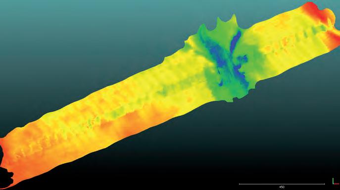
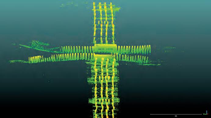
Dataset from the Fort Pierce Inlet, 2019. Delivered as one large point cloud to process, it was originally two merged point clouds from both a multibeam survey and Teledyne BlueView laser scan of the pilings and bridge structure. Fort Pierce Inlet, Florida. Inlet Mouth. View into the West.


Full dataset, view into the North. Pilings, view into the North. Post CSF application. Non-ground points.
inverted and a rigid cloth is laid on the inverted surface. During the simulation, cloth is modelled as a grid that consists of particles with mass and interconnections, called a Mass-Spring Model. By analysing the interactions between the cloth nodes and the corresponding points, the locations of the cloth nodes can be determined to generate an approximation of the ground surface. The ground points are then extracted from the point cloud by comparing the original points and the generated surface [1].
This filtering method only requires a few easy-to-set integer and Boolean parameters, and takes less than a couple of minutes to process. The accuracy stands up to other toolsets and it has the functionality found in proprietary commercial software. Benchmark datasets provided by ISPRS (International Society for Photogrammetry and Remote Sensing) working Group III/3 were used to validate the filtering method, and the experimental results yielded an average total error of 4.58%, which is comparable with most state-of-the-art filtering algorithms [2].
ClassiFying Point Clouds
Parameters in the selection dialogue are split into general parameters and advanced parameters. General parameters allow the user to specify whether the scene is relatively flat, contains associated relief, or is steeply sloping, which determines the rigidness of the cloth. Note that, for steep slopes, this algorithm may yield relatively large errors as the simulated cloth is above the steep slopes and does not fit with such ground measurements well due to internal constraints among particles. This problem can be solved by selecting the option for steep slopes. If there are no steep slopes in the scene, this can be ignored.
Advanced parameter settings contain three constraints to assist with the level of detail and refinement. The integers shown when the filter dialogue is selected are standard and should be appropriate for most datasets. Cloth resolution is the grid size of cloth used to cover the terrain. The bigger the cloth resolution integer set, the coarser the DTM (Digital Terrain Model) that is produced will be. Max. iterations refers to the maximum iteration times of terrain simulation. Classification threshold refers to a threshold to classify the point clouds into ground and non-ground parts, based on the distances between points and the simulated terrain.
oPen-sourCe and maChine learning
This dataset is from the Fort Pierce Inlet in 2019. Delivered as one large point cloud to process, it was originally two merged point clouds from a multibeam survey and a Teledyne BlueView laser scan of the pilings and bridge structure. Since the separate bare earth and structure files were not provided, the CSF was ideal for this dataset. The client was concerned about scour around the pilings, and desired to see a quick visualization of the depth. As the point cloud is inverted during extraction, the depth of the scour could be shown in detail.
The extraction or refinement of coral heads and boulder piles within the scour needed to be manually performed with CloudCompare’s segmentation tool or a separate tool process as the surface is produced from inversion. Retaining the same coordinate and height values, despite the various tool processing techniques applied, is a bonus for data integrity. Another benefit of the CSF algorithm is that the simulated cloth can be directly treated as the final generated DTM for some circumstances, which avoids the interpolation of ground points, and can also recover areas of missing data [2]. The user can additionally check a box for a separate meshed (Delaunay Triangulation 2.5D XY plane) surface export once the filter has extracted the ground points. The use of insightful and synergistic programmes such as CloudCompare, open-source softwares, machine learning and automation will continue to gain traction as collaborative atmospheres continue to grow and influence niche industries such as hydrographic ventures. This allows for ease and interoperability in future scientific communities.
acknowledgment
Cloud Compare, created by Daniel Girardeau-Montaut. https://www.danielgm.net/cc/
Citations
1: http://www.cloudcompare.org/doc/wiki/index. php?title=CSF_(plugin) 2: Zhang W, Qi J, Wan P, Wang H, Xie D, Wang X, Yan G. An Easy-to-Use Airborne Lidar Data Filtering Method used to test this method. Guangjian Yan helped to review this manuscript and give much advice.
Rachel Bobich, owner of RMB GEO, is an independent contractor in the marine and geospatial data industries. She specializes in multibeam acquisition and processing, satellite imagery analysis and open-source tool suites. Her career has taken her into the GEOINT division programme with the NGA, and she was previously GIS manager for the Department of Natural Resources, Marine Resource Division in South Carolina. She has worked closely with government agencies and private organizations such as NOAA and Mote Marine Laboratories. Navigating new solutions to existing workflows and optimizing organization and collaboration are her core values.
IHO & GEBCO: Providing Valuable Data to Care for Our Oceans
When people think of depth data, the first things that usually jump to mind are maps and navigation, even though the implications for this work actually extend well beyond these areas. The shape and texture of the seabed are important for a wide range of ocean processes, and can influence climate, pollution, biodiversity, and so on. The International Hydrographic Organization (IHO), one of the General Bathymetric Chart of the Oceans (GEBCO) project’s parent organizations, celebrates its 100th anniversary on 21 June 2021, and we felt it would be a good opportunity to look at why depth data matters.
Detailed bathymetry is the information that helps us to determine what the seabed looks like. Just as above water there are mountains, hills and valleys, the same is true underwater. The shape and texture of the seabed can influence tides and currents, which guide the movement of pollutants in the oceans and seas, as well as determining the speed of tremor and tsunami wave propagation. The seabed provides habitats for marine species and plays a role in spawning areas; information which is useful for initiatives aimed at protecting biodiversity. The seabed also plays a role in ocean circulation, which in turn has an impact on the climate and the atmosphere. IHO Member States and other GEBCO partners are collecting depth data, which is becoming increasingly accurate thanks to progress in technology, and which can be used, for example, to refine and improve the accuracy of climate change impact models. A complete picture of the seabed can help ensure that initiatives for the sustainable use of the oceans are targeted and effective.
Participants in GEBCO merge all of this information, which is relevant for all ocean stakeholders and can contribute to the development of the blue economy. Knowledge of the seabed, together with other hydrographic data obtained during sea surveys, is the basis of all marine activities and has a wide variety of applications. Information related to the topography of the seabed or the strength and regularity of currents can be used by operators to develop marine renewable energy projects, while industries like fishing and aquaculture can benefit from information on environmental factors like temperature, salinity and currents – information that is recorded in detailed digital charts.
GEBCO is an IHO & Intergovernmental Oceanographic Commission of UNESCO joint project to collect bathymetric data and map the oceans. It was launched by Prince Albert I of Monaco in 1903, and some of the initial data was collected during his research expeditions.
The IHO, an intergovernmental organization, was created in 1921 and works with its 94 Member States to increase knowledge of the ocean. It works to ensure that all of the world’s seas, oceans and navigable waters are surveyed and charted, and it coordinates the activities of national hydrographic offices and promotes uniformity in nautical charts and documents. It also issues survey best practices, provides guidelines to maximize the use of hydrographic survey data, and develops hydrographic capabilities in Member States.
Hydrography focuses on the physical features of oceans, such as the shape of the seabed, depth, temperature, currents and sea level. There is a lot of overlap with disciplines such as oceanography, and much of the information collected is relevant to the larger discussions currently taking place on increased knowledge and protection of the ocean, such as the UN Decade of Ocean Science for Sustainable Development and the Sustainable Development Goals.
About GEBCO
The General Bathymetric Chart of the Oceans (GEBCO) partners with The Nippon Foundation in the Seabed 2030 Project. GEBCO is a joint project of the International Hydrographic Organization (IHO) and the Intergovernmental Oceanographic Commission (IOC) of UNESCO – the United Nations Educational Scientific and Cultural Organization. It is the only intergovernmental organization with a mandate to map the entire ocean floor.
About The Nippon Foundation
The Nippon Foundation (founded in 1962) is a private, non-profit foundation that is jointly spearheading international efforts to map the entirety of the world’s ocean floor by the end of the next decade. More than 100 organizations are now contributing to the goal of producing a complete map, which is vital to exploration.

