8 minute read
Surveying the Arctic by Sailboat
Bathymetric Mapping of the High Arctic for Ocean Modelling and Charting Surveying the Arctic by Sailboat
Bathymetric soundings in the Canadian Arctic are sparse, especially in the High Arctic (>75°N), where large sections of coast and the continental shelf are completely uncharted. The lack of accurate bathymetry severely limits the accuracy of ocean circulation models and the understanding of how marine-terminating glaciers in the region will respond to a rapidly changing ocean climate.
The Canadian High Arctic is undergoing some of the most rapid climate forcing on the planet, with regional air temperatures increasing at twice the global average. Accelerated melting of the extensive ice fields and glaciers of the Canadian Arctic Archipelago (CAA) has led it to be the largest contributor to global sea-level rise outside of Greenland and Antarctica. Climate forcing by atmospheric warming, however, is only one part of the equation. Glacier mass loss by calving of icebergs and submarine melting driven by warm ocean water is another key factor, yet these glacier-ocean interactions remain largely unstudied in the CAA. Marine-terminating glaciers also change ocean properties by reducing water temperatures and releasing fresh water into the ocean, altering ocean stratification and circulation. Understanding these feedback mechanisms is critical to the prediction of future glacial contributions to sea-level rise and the ocean’s response to climate forcing. However, the accuracy of predictions is fundamentally limited by knowledge of the geometry of the problem.
GEOMETRICAL CONSTRAINTS
The geometrical constraints on glacier-ocean interactions are numerous: 1) the height and topography of the submerged portion of the glacier face determine the area subject to submarine melting; 2) the depth of the seabed at the glacier grounding line defines the depth of freshwater discharge into a fjord and buoyancy-driven fjord circulation as well as the properties of ocean water in contact with the ice (water temperatures generally increase with depth in the Arctic); 3) the bathymetry of the receiving fjord influences the vertical distribution of water masses that can propagate to the glacier termini through the presence of sills and shoals; and 4) the topography of the continental shelf determines regional ocean circulation patterns and the properties of ambient waters present at fjord mouths via deep troughs that cut across the continental shelf.
At present, most fjords and vast sections of the continental shelf in the CAA remain uncharted, owing largely to the region’s harsh climate and inaccessible ice-covered seas. Therefore, existing bathymetric grids of the CAA underlying state-of-the-art ocean circulation models are based on interpolations between very sparse soundings. The models then fail to capture the complexities of seabed topography and its influence on ocean circulation, water mass transformation and glacier-ocean interactions. There is a strong need to develop new cost-effective mapping programmes in the High Arctic to improve data coverage, particularly in the shallow uncharted nearshore areas that larger vessels with deep draft are unable to access safely.
INNOvATIvE RESEARCh PROGRAMME
In 2019, the Canadian Glacier-Ocean-Iceberg Dynamics in a Changing Canadian Arctic (GO-Ice) project began with the goal of better understanding glacier-ocean interactions in the CAA. A key objective of the project is to survey previously uncharted coastal regions, particularly the glacial fjords and coastline of south-east Ellesmere Island and north-east
Photo 1: A marine-terminating glacier on Ellesmere Island in the Canadian High Arctic (G. Joyal).

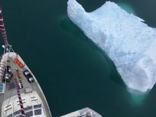
Photo 2: The SY Vagabond surveys iceberg waters in the Canadian High Arctic (A. Hamilton).
Photo 3: Pole-mounted Sonic 2026 installed on the polar sailboat Vagabond for surveying the uncharted waters of the Canadian High Arctic (E. Brossier). (Inset) Map of the 2019 and 2020 cruises showing multibeam surveys in red.

Devon Island (Nunavut, Canada), where numerous marine-terminating glaciers drain into northern Baffin Bay and Jones Sound. To accomplish this objective, the research team partnered with a crew of experienced Arctic sailors aboard the 47-foot (15.3-metre) polar sailing yacht the Vagabond. The team has spent two seasons conducting oceanographic research and hydrographic surveys in the CAA from this novel platform, with the surveys serving the dual purposes of improving ocean model bathymetry and providing valuable data to the Canadian Hydrographic Service (CHS) to update nautical charts. The project has developed as a transdisciplinary collaboration between academics, industrial partners, government and northern communities, and aims to contribute to the Seabed 2030 project to see the global ocean fully mapped by 2030. Given the remoteness of the area and the unknown seabed topography, the research team chose to utilize a portable, low-power multibeam echo sounder with a large dynamic range, the Sonic 2026, generously provided in-kind by industrial partner R2Sonic Inc (Texas, USA). Using this Sonic 2026, the Vagabond mapped more than 3,500km2 of previously uncharted waters during the 2019 and 2020 cruises, in depths ranging from 5m to 750m, including mapping the vertical walls of marine-terminating glaciers. Surveying in this remote polar environment presents numerous challenges: a robust pole-mounted system had to be fabricated to withstand operation in ice-covered seas; static and dynamic calibration of all sensors had to occur at sea (there are no dry docks in the Canadian Arctic); navigation data required careful post-processing because satellite coverage is poor at these high latitudes; numerous sound velocity profiles were required for refraction corrections due to highly stratified waters near glacial meltwater plumes; and the vessel had to safely navigate in uncharted and iceberg-strewn waters.

GLACIAL GEOMORPhOLOGy
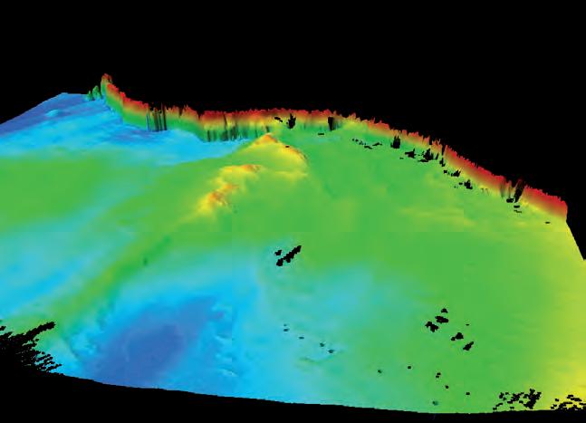
The multibeam survey has shown impressive early results. In an unnamed bay on south-east Ellesmere Island, the terminus of a glacier and adjacent seabed topography was mapped. The data show a vertical ice face that is grounded between 40m and 100m below sea level, punctuated by a large subglacial channel where fresh meltwater is discharged into the fjord at depth. The seabed in front of the terminus shows high relief: a submerged esker (winding ridge of glacially deposited sediment) rises 60m above the surrounding seafloor, and recessional moraines (narrow ridges parallel to the ice face) and iceberg scours mark the bed. This snapshot provides a remarkable window into the complex geometry of the glacier-ocean intersection that greatly informs our understanding of the physical processes at work in driving patterns of glacial retreat. A repeat survey planned in 2021 will reveal even further insight into the dynamic nature of this complex system.
ChART PROduCTION ANd uPdATES
The utility of the survey goes beyond glacier-ocean research and numerical modelling. The cruise track is planned in collaboration with the CHS in order to map high-priority uncharted waters at IHO standards, such as those in active shipping lanes. This collaboration is crucial to ensure safe navigation in the ecologically sensitive High Arctic,
especially as marine traffic is increasing as sea ice cover retreats. Northern communities in the CAA are extremely dependent on annual resupply by ship, so our efforts help, in a small part, to ensure the safe passage of critical goods to these remote communities.
COnClusIOns
Surveying polar regions is challenging and expensive. However, the need to map the Arctic is critical, given the rapid changes occurring in the polar regions and their global impacts. By collaborating across various sectors of marinestakeholder communities, the Vagabond research cruises have demonstrated how hydrographicquality multibeam data can be collected in remote areas at relatively low cost through trusted crowdsourced partners. The survey products benefit basic climate research, improve the capacity of federal hydrographic programmes to map territorial waters, and contribute to the world’s efforts to completely map the ocean floor. Seemingly lofty goals perhaps, so why not aim for a more sustainable world at the same time, and do it all from a sailboat?*
*The authors readily acknowledge that the vast majority of surveying during the Vagabond cruises was done under engine power; however, a few surveys were conducted under sail alone.

Photo 4: High-resolution multibeam data of a glacial fjord on Ellesmere Island, Canada, showing the vertical glacier wall and the complex seabed near the terminus. Improved underwater topography such as this vastly enhances efforts to accurately model glacier-ocean interactions.
Photo 5: Surveying the remote coasts of the Canadian High Arctic is a significant logistical challenge, but the data acquired by the SY Vagabond benefits fundamental research and federal charting agencies (G. Joyal).
ACknOwledGements


The authors are indebted to support from each of the following individuals and organizations: the SY Vagabond crew Eric, France, Léonie and Aurore; Jimmy Qaapik; George Schlagintweit (CHS); Luke Copland (UOttawa); Paul Myers (UAlberta); Maya Bhatia (UAlberta); Jochen Halfar (UToronto); the community of Grise Fiord, Nunavut; the community of Arctic Bay, Nunavut; R2Sonic Inc.; QPS; the Polar Continental Shelf Project; National Science and Engineering Research Council of Canada; ArcticNet, a Network of Centres of Excellence of Canada; and the Canadian Hydrographic Service.
About the GO-Ice project
Glacier-Ocean-Iceberg Dynamics in a Changing Canadian Arctic is a collaborative research project led by Dr Luke Copland at the University of Ottawa and supported by ArcticNet, a Network of Centres of Excellence of Canada, to investigate the state of glaciers and oceans in the Canadian High Arctic. It aims to provide the most up-to-date monitoring of changes in glacier mass balance and ocean circulation, to better understand the atmospheric and oceanic drivers of glacier change and the impact of meltwater and a warming Arctic on ocean circulation. An interdisciplinary team of researchers utilizes an array of methodologies to address these questions, ranging from extensive field programmes at various sites across the High Arctic, to analysis of remote sensing data, numerical modelling and partnership with northern communities.
Andrew K. Hamilton is a postdoctoral fellow at the University of Alberta studying glacier-ocean interactions in the Canadian Arctic. He holds a PhD in environmental fluid mechanics from the University of British Columbia, has been conducting glacier-ocean field work in the High Arctic for 14 years, and is lead scientist on the GO-Ice Vagabond research cruise. akhamilt@ualberta.ca
Gabriel Joyal is a geomatics researcher at the Centre de géomatique du Québec, a college R&D and technology transfer centre. He holds an MSc in physical geography form Université Laval. He has been working in the Canadian Arctic for over seven years, mapping lake and sea beds as part of various research programmes including Cape Bounty Arctic Watershed Observatory (2013), ArcticNet CCGS Amundsen cruises (2014-2018) and GO-Ice (2019-2020). gabriel.joyal@cgq.qc.ca


