15 minute read
Robotics and Automation Advance the Offshore Wind Industry
Increased Integration of Remote Technology Will Transform Maritime Operations and Maintenance Practices
Robotics and Automation Advance the Offshore Wind Industry
During the life cycle of offshore wind farms (OWFs), operators must maximize the uptime of wind turbines to generate as much energy as possible. As OWFs are constructed further from the coast, maintenance and inspection with crewed vessels becomes increasingly risky, time-consuming and expensive. To overcome this challenge, the industry is turning to remote and autonomous technological solutions that can support OWFs far out at sea.
The integration of autonomous technologies brings significant benefits for the offshore wind industry, including improved safety and efficiency and reduced overall environmental impact. A key example is the accelerated design and development of uncrewed surface vessels (USVs) that can perform tasks in remote offshore locations while being controlled from remote operations centres (ROCs) as far away as in different time zones. With a wide range of applications, from seabed and asset data acquisition to research, surveillance and marine exploration, USVs are set to transform the maritime business and lay the foundations for a new way of working in the offshore wind industry.
USV technology does not replace the need for skilled personnel within the industry; rather, it has the potential to allow them to work more efficiently and in a safer ROC environment. The ability to deploy, manage and operate uncrewed vessels from ROCs anywhere in the world means that fewer people need to work in extreme and potentially hazardous offshore environments. Additionally, USVs offer an extremely efficient mode of data acquisition, allowing maritime staff to prioritize complex analytical tasks rather than spending time supporting the delivery stages. This leads to another advantage: increased output and speed of the delivery of high-quality insights to clients, using cloud-based processing and reporting solutions so that clients can receive the first results just hours after initial data acquisition, anywhere in the world. The integration and adoption of USVs will also significantly benefit the overall environmental impact of marine expeditions and operations. Some USVs have hybrid diesel-electric engines that allow vessels to operate further offshore, increasing the operational window while also significantly lowering the carbon footprint. At Fugro, we see USVs playing a prominent role in the future of maritime exploration and operations and, as such, we have partnered with SEA-KIT International, a global provider of hi-tech solutions to maritime and research industries. Through this partnership, we are helping to drive the development of USVs to support the greater use of remotely operated vehicles and autonomous underwater vehicles to inspect marine assets.
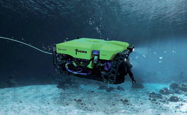
Fugro designed Blue Volta electric ROV, performing a seabed inspection off the coast in Australia.
InnoVatIon BrIngS new challengeS
While the benefits of USVs are undeniable, these technological advances have uncovered further challenges. Offshore robotic solutions work most efficiently when there is a local, in-field facility that can accommodate the systems for safety, recharging and data transfer in an autonomous capacity that does not need onboard personnel. Without this offshore support, USVs and other autonomous robotic solutions regularly have to travel large distances to coastal locations such as marinas or ports for
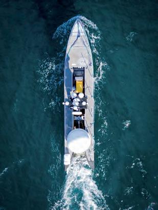
Impression of the Fugro Blue Essence USV, preparing to RoboDock at IJmuiden port, The Netherlands.
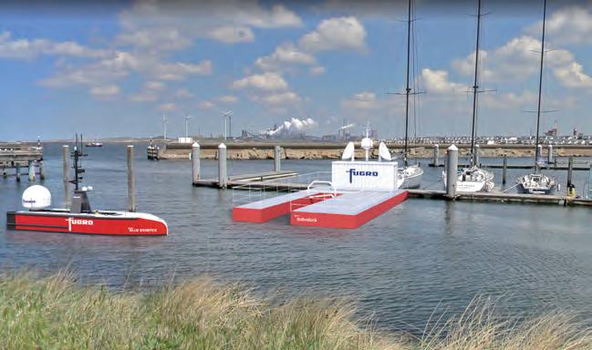
recharging and data transfer, which consumes time and fuel that could otherwise be used to deliver operation and maintenance plans. Thus, to ensure that OWFs can maximize the capabilities of autonomous solutions, Fugro is developing an automated docking platform from which uncrewed vessels can perform inspection and maintenance operations. This ‘RoboDock’ platform will enable various uncrewed vessels and drones to carry out inspection tasks both above and below the sea’s surface, as well as serving as a recharge station. Effectively eliminating the need for autonomous assets to return to shore, RoboDock will incorporate storm-resistant docking points, automated launch and recovery, and charging points. The platform will also facilitate data download to and communication with the onshore ROCs, and ongoing monitoring of wind farms.
SettIng a new IndUStry Standard
This cutting-edge technological breakthrough will not only allow the offshore wind industry to accelerate the adoption of remote and autonomous solutions, but will also have huge safety advantages. By deploying RoboDock, the offshore industry can remove human workers from extreme environments to de-risk offshore operations. Additionally, compared to current practices that require large support vessels, robotic operations will consume far less energy, making them a more sustainable long-term solution. RoboDock is designed to be operational year-round and will withstand challenging weather conditions. While the initial prototype will be small-scale, the platform will demonstrate its potential as a scalable technology that could be used to create large floating offshore hubs and maintenance islands for deploying robotic and autonomous technologies. For example, RoboDock stations could offer coastal security and coastguard operations support, aiding in maritime search and rescue, and shipping traffic and environmental monitoring. RoboDock also offers a number of potential applications within the scientific community. These include advanced monitoring, research and acquisition of environmental and metocean data via the addition of sensors to the RoboDock platform, or cameras for advanced subsea flora and fauna surveys. In this way, the platform could help scientific researchers gain a better understanding of the pressures affecting marine and coastal environments, and therefore support environmental protection programmes. As a support system, RoboDock could benefit activities as varied as wind farm security, coastguard operational support, maritime aid, search and rescue, monitoring of shipping traffic and many more.
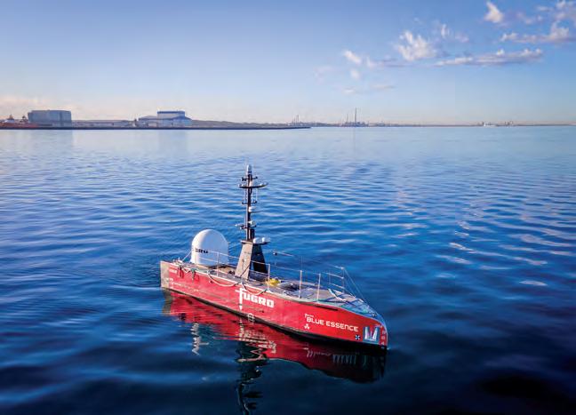
Fugro Blue Essence USV performing inspection off the coast in Australia.
Aerial view of Fugro Blue Essence USV performing a survey using Fugro Blue Volta electric ROV.

the fUtUre IS remote
The offshore wind industry will significantly benefit from the uptake of remote technology at every level. Innovations such as RoboDock will help to bring about faster, more efficient and safer operations, functioning on a significantly more sustainable scale and accelerating the maritime industry’s digital transformation. Robotics and automation will ensure a continued drive to increase the maximum energy output of wind farms throughout their entire life cycle and will expand the capabilities of offshore wind and other maritime operations.
for more information:
Ivar de Josselin de Jong i.josselin@fugro.com
Ivar de Josselin de Jong is director for remote inspection at Fugro. His career started in site investigation and high-end geophysics. He later moved to O&G IRM and Offshore Wind O&M solutions and has gained a broad experience in the maritime arena. His current focus is enabling the transition to remote and autonomous operations, with ongoing USV developments in partnership with SEA-KIT, developing the Blue Essence and Blue Eclipse USVs, and the nextgeneration electric ROV programme. He holds an MSc in Geology from Utrecht University in The Netherlands. i.josselin@fugro.com
IIC Academy Hydrographic Surveying Course
An Introduction to the S-5 Category B Programme
Hydrography plays an important role in the economic and social development of nations. The proper mapping of the coastlines and bodies of water of a nation helps with the management of natural resources, preservation of marine species and habitats, marine trade, defence, safety for navigation through national and international waters, and more.
Professional-level Training
IIC Academy’s S-5 Category B Hydrographic Surveying programme has been recognized by the FIG/IHO/ICA International Board on Standards of Competence for Hydrographic Surveyors and Nautical Cartographers (IBSC) and is designed to maximize the advantages of online delivery, especially considering the circumstances imposed on us by the Covid-19 pandemic.
The iiC aCademy’s s-5 CaTegory
B programme provides candidates with the theoretical and practical competencies necessary to effectively conduct the planning and implementation of hydrographic surveys at a professional level.
maximized online delivery
IIC Academy offers the S-5 Category B programme flexibly, in tune with the health and safety requirements of the world today. By utilizing online learning and communication tools that have become so familiar during the Covid-19 pandemic, students are trained without the normal expectation or expense of having to move to distant geographic locations for the full duration of the programme.
TheoreTiCal and PraCTiCal exPerienCe
IIC delivers this programme in an engaging manner, utilizing a learning framework that blends relevant theory and practice. The programme gradually guides students through the topics, from basic to advanced degrees of difficulty, both in the theoretical and practical knowledge areas. The practical tasks reinforce the theory of each topic and evolve students’ competencies from supervised sessions to autonomous work. Students benefit from having a team of instructors leading and monitoring them throughout the programme. This is continued and strengthened when students co-locate with their instructors for the practical and assessment portion of the programme.
is This Programme for me?
IIC’s S-5 Category B Hydrographic Surveying programme is designed for both surveyors in the early phase of their career and new candidates with some relevant previous education who want professional-level training at the Category B level. The programme’s remote learning delivery allows employees and employers the flexibility to customize the timing of the learning process so that it best fits into their work schedules, potentially enhancing the training through practical synergies.
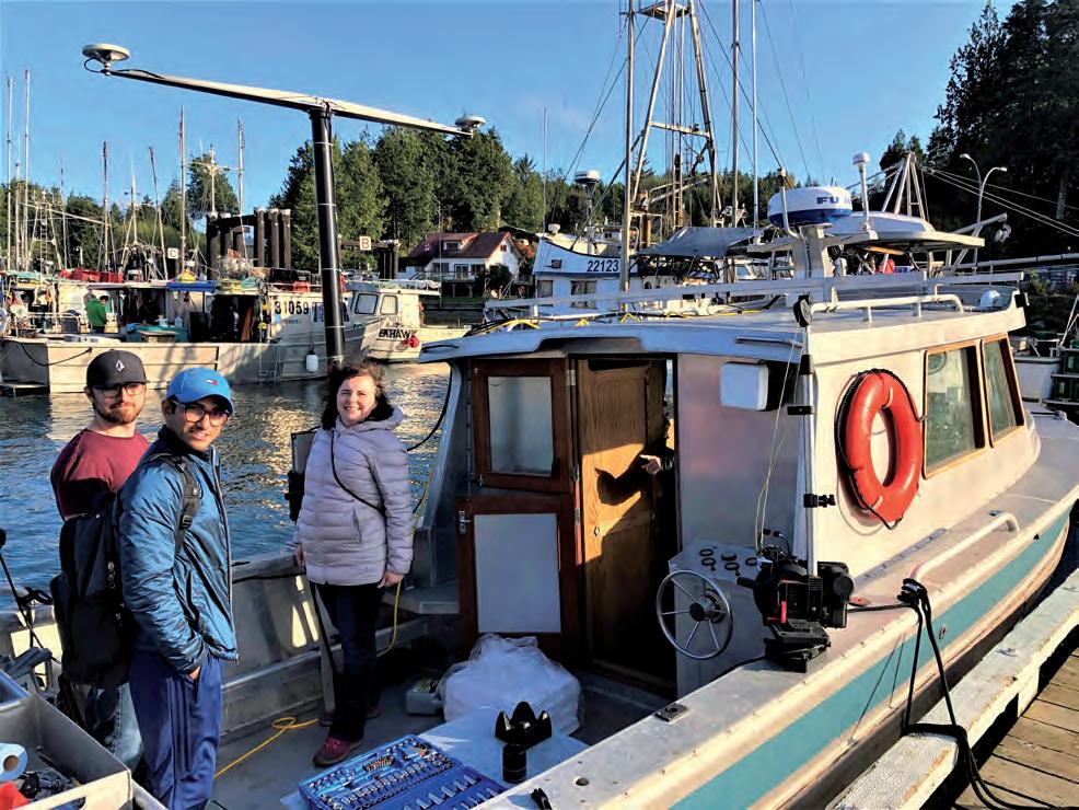
IIC Academy instructor Veronique Jegat and students prepare for surveying field exercises.
WhaT Will i learn?
The content of the programme has been carefully designed to align with the content and intended learning outcomes defined by the FIG/IHO/ICA guidelines. The learning outcomes have been organized into modules, units and lectures, with the following structure: • Introduction to hydrographic surveying • Computation tools • Nautical science • Environmental science • Positioning • Underwater acoustics • Water levels • Quality control • Remote sensing • Hydrographic practice • Hydrographic data management • Comprehensive final field project
Programme deTails and Timeline
IIC Academy’s Hydrographic Surveying programme – global delivery runs for a total of 20 weeks, divided into three phases: • Phase 1, Theory/remote learning. The programme delivers 13 weeks of remote learning to cover all of the required theory, in the comfort of the student’s home or office; this includes instructor-led webinars and e-learning modules. • Phase 2, Practicals. The remote learning phase is followed by three intensive (condensed) weeks of on-site practicals.
These practicals review and consolidate the theoretical material delivered during the remote learning phase. The practicals are held in three scheduled regions of
America, Australasia and Europe. • Phase 3, Final assessment. The programme completes with a fourweek period in which the student completes a comprehensive final field project. This project is designed to confirm that students have all the necessary theoretical knowledge and practical skills to plan, conduct, assess and submit a hydrographic survey.
Although the final field project is considered to be the central component for graduation, students are regularly tested throughout the programme using in-lecture quizzes, simple practical exercises, written exams and data processing tasks. This is designed to ensure that the students are obtaining the understanding and ability that they require throughout the course, and to identify where additional in-course training and assistance may be required.
An overall and tangible benefit of the structure of this programme is that it is designed to parallel how hydrographic surveying teams work in practice.
How do I Enrol?
Those interested in enrolling in the programme or requiring further information can visit:
www.iictechnologies.com/sites/default/files/iicacademy/ IICS5Program.html
or contact hydrographicsurveyor@iicacademy.com.
How a Small California Company is Innovating in Turbulent Times
Breakthrough on the Horizon; Giving Sight to USVs
Every player in the survey industry has been affected by the pandemic in unique ways. What each had in common though, was an almost complete halt of face-to-face interaction with competitors and collaborators alike. Seafloor Systems, based in Northern California, took this opportunity to focus on its product development and advance the autonomous capabilities of its existing remote survey platforms.
AutomAtion for HydrogrApHers
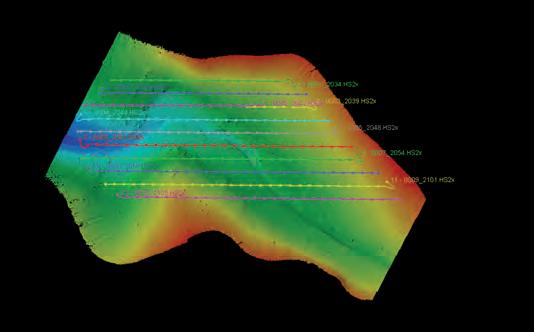
Seafloor Systems has been designing and building Uncrewed Surface Vessels (USVs) for over a decade. From drawing board to field testing, the team of twenty-five employees pumps out remote platforms for a variety of clients and disciplines within the land and hydrographic survey sectors. Its star products, robot boats, make it possible to send pro-grade instrumentation and sensors into areas that a crewed vehicle would find challenging (streams, dredge ponds, shorelines, etc). The employees at Seafloor Systems are no strangers to pioneering technologies for remote, hydrographic survey applications. When Seafloor launched its AutoNav control system for USVs in 2015, users were given the ability to pre-programme remote vessels to follow track lines in the water and carry out hands-free missions. The AutoNav, which is still a staple product, reduces overlap in sonar beam swathes and ensures clean, consistent data collection. Even so, the AutoNav has limitations when obstacles stray into the pre-planned route without warning.

However, the biggest obstacle in the way of recent efforts to address the AutoNav’s limitations was the onslaught of the worldwide pandemic. Fractures in the global supply chain and mandatory stay-at-home orders made it difficult for businesses to operate, let alone invest in new projects. Despite this setback, the nimble Seafloor crew set a goal to pioneer a package that could be integrated into USVs to autonomously navigate around obstacles during survey missions on water. In other words, they wanted their robot boats to see, identify and react to surface threats in real time.
A Vision for future uncrewed Vessels
It is no easy task building a computer vision navigation system for uncrewed vessels. Not only would it have to identify obstacles in the path of the survey mission, but also react to them in real time and adjust the steering propellers to avoid collisions. Luckily, there is a company out there that helps clients do just that. AlwaysAi, a leading provider of flexible ways to build and deploy computer vision applications to a wide variety of devices, offered up its platform for the Seafloor team to build from. With a strong artificial intelligence partner secured, Jenna Opsahl and Marcos Barrera, Seafloor’s computer vision and robotics specialists, began the daunting
Seafloor’s AutoNav enables Uncrewed Surface Vessels (USVs) to follow a pre-programmed route. This semi-autonomous feature increases survey efficiency and repeatability.
Bounding Boxes are placed around common maritime objects to train the computer vision model to better identify obstacles in the USV’s survey path.
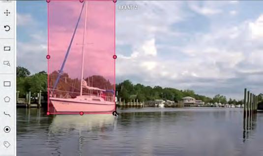
task of formulating a computer vision model specific to maritime environments. (There are several land-based models out there, but limited options for the niche maritime survey industry). Opsahl collected and sifted through video clips frame by frame that contained objects commonly found in bodies of water. Boats, buoys, ducks, plants – anything that was above the surface that might pose an obstacle for unmanned vessels – were selected with bounding boxes and labelled so the artificial intelligence model could learn and adapt. Barrera was tasked with developing a perception and control infrastructure that would work in tandem with the computer vision model. For this, he utilized Amazon Web Services (AWS) IoT Greengrass, which enables programmers to remotely manage and operate software on devices in the field. The obstacle avoidance package for USVs began to take shape.
testing tHe wAters – cV success
Fast forward a few months and hundreds of hours of annotating through video footage, and the team was on the cusp of testing a prototype. The computer vision model had seen leaps in object recognition abilities, and COVID restrictions were simultaneously being lifted in California. The Seafloor crew met in San Diego (the first time in person in almost a year) to test the obstacle recognition and avoidance system on an EchoBoat-160 USV. Initial testing garnered promising feedback. The computer vision model, now integrated into the EchoBoat-160’s AutoNav, picked up on several objects in the water and indicated its confidence (in a percentage) that it was, in fact, that object. For example, when the vessel stumbled upon an inflatable inner tube, the model determined it was 94.01% certain that it was a ‘raft’.
Now it was time to see if the vessel could identify objects along a plotted survey route and react accordingly. Seafloor’s Ocean Engineer, JT Meyers, volunteered to cruise out on his paddle board to play the role of an unsuspecting bystander. A navigation route was programmed into the vessel’s AutoNav from the shore, and Meyers positioned himself between two of the wayfinding points to create an obstacle. To the team’s surprise, the computer vision system picked up the paddleboarder with no issue, and quickly altered the vessel’s path to avoid a collision. Computer vision success.
mAcHine leArning for tHe future
With a successful obstacle avoidance test under their belts, the research and development team at Seafloor could now take a deep breath. Months of tinkering with machine learning and limited face-to-face collaboration stemming from the global pandemic were turned into the triumph they were all hoping for. This technology is scheduled to be introduced into various Seafloor remote survey platforms of the future to advance the autonomous capabilities of unmanned vessels. For now, the team says their work is not done. Further training of computer vision models will take place to account for different environments, objects and scenarios. Innovation can arise in some of the most turbulent times, and obstacle avoidance is just one of the advancements driving the hydrographic survey industry forward.

The computer vision model on board the EchoBoat-160 USV determined with 94.01% confidence that the obstacle in its way was a raft.
Computer Vision Success. The USV avoided the paddleboarder, altering its pre-programmed route (green line) to go around the obstacle and continue surveying (white line).


