12 minute read
Sentinel-2 Satellite-derived Bathymetry in Optically Complex Waters


Dublin Bay Case Study Sentinel-2 Satellite-derived Bathymetry in Optically Complex Waters
BACKGROUND
Coastal areas are highly dynamic environments that are subject to diverse pressures, both anthropogenic (e.g. urban development, fishing, habitat modification) and natural (e.g. storms, erosion, floods). These pressures result in intensive and frequent seafloor alterations that demand efficient monitoring methodologies to produce repetitive updating of the seafloor morphology and bathymetry. Bathymetric information is essential in many coastal aspects, including environmental, management, research and economic. Optical satellite data provides an efficient alternative to bathymetric derivation in shallow coastal waters (<30m), overcoming financial, temporal and logistical constraints. In 2015, the European Commission, in partnership with the European Space Agency (ESA), launched the first satellite of the Sentinel-2 mission within the Copernicus Programme. This mission currently has two satellites, Sentinel-2A and Sentinel-2B, which register data with a spatial resolution of 10m in some spectral bands. The combination of both satellites provides a revisit time of five days, depending on the latitude. These characteristics offer new potential for coastal applications in general, and satellite-derived bathymetry in particular.
SATELLITE-DERIVED BATHYMETRY APPROACHES
When using remote sensing data to extract bathymetry, three main techniques can be differentiated: empirical approaches, empirically tuned physics-based approaches, and optimization-tuned physics inversion approaches. Empirical approaches such as machine learning are the newest methods and are not commonly used. The empirically tuned physics-based approaches have the most extended history and are still the most frequently used. In these methods, water column contributions and light attenuation properties are empirically derived from the satellite images by regression with in situ depth data (e.g. nautical charts, echosounder data or Lidar). However, water turbidity and the seafloor’s influence can limit the performance of these algorithms, which may also be location- or data-limited. The optimization-tuned physics inversion approaches are more complex, but their use has been consolidated for satellite-derived bathymetry. The application of inversion models does not require in situ depth data, but rather the specification of a range of water optical properties and the seafloor substrates reflectances. These approaches can provide per-pixel uncertainties.
ATMOSPHERIC CORRECTION
The correction of atmospheric effects is considered a critical step for obtaining accurate satellite-derived bathymetry data. At satellite altitude, up to 90% of the sensor-measured signal can be due to atmospheric and surface reflectance. In this project, several atmospheric correction processors were evaluated to test their influence on satellite-derived bathymetry maps. These processors were OLI ‘lite’ (ACOLITE), the Sentinel-2 data correction (Sen2Cor version 2.4), the image correction for atmospheric effects (iCOR), the Case 2 Regional CoastColour processor (C2RCC), and the Depth Water Correction (DWC). All of these use an image-based approach, which means that all input data is derived from the image itself or provided through pre-calculated lookup tables. Sen2Cor, C2RCC and iCOR are available through the ESA’s Sentinel toolbox in the Sentinel Application Platform (SNAP), and DWC is implemented in the Image Data Analysis (IDA) software developed by Numerical Optics Ltd.
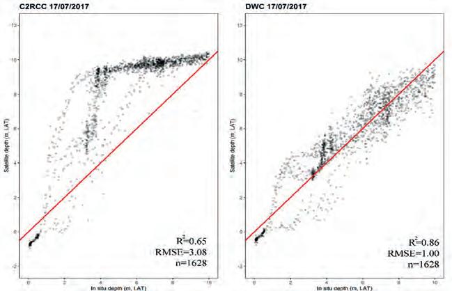
Results showed that the DWC approach produced more accurate and less biased satellite-derived bathymetry maps. This result was not surprising, since the DWC method is specifically designed to correct imagery for applying the bathymetric model.
EMPIRICAL TUNING MODELS VS MODEL INVERSION METHODS
The availability of two Sentinel-2 satellites that can provide a revisit time of three days in Ireland is of enormous importance. This temporal resolution increases the chance of
obtaining good images in areas with significant limitations due to weather and water surface conditions. However, even when the Sentinel-2 images were registered in ‘optimal’ conditions, some areas presented certain challenges for satellite-derived bathymetry. The analysis of the scatterplots (with associated diagnostics) between satellite-derived depth and in situ depth revealed high variability in the results and a clear dependence on the ‘quality’ of the image used. Local and variable turbidity events had an impact on satellite-derived bathymetry, causing an underestimation of depth values. Dark bottom types such as rock and macroalgae also had an effect on satellite-derived bathymetry, potentially causing an overestimation of depth values. The comparison of empirical tuning models and optimization-tuned physics inversion models showed similar results in Dublin Bay. Model inversion approaches produced an average RMSE and R2 of 1.60 and 0.74 respectively between 0 and 10m depth. The lowest RMSE value was obtained in Dublin Bay on 17/07/2017 (RMSE = 1.00), and was coincident with the image where the highest R2 value (R2 = 0.86) was found. These numbers were quite similar to the ones obtained in previous studies using empirically tuned methods in the same study area. These studies reported values of R2 > 0.80 and average RMSE values of 1.05.
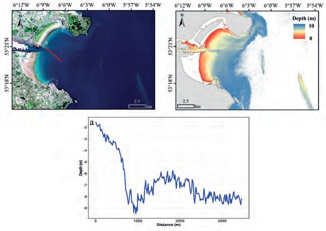
Empirically tuned methods worked well in Dublin Bay because the bay presents a homogenous bottom type and the Sentinel-2 images were selected close to optimal conditions (e.g. low turbidity). However, even if they are more straightforward and easier to use, empirically tuned methods require in situ training data, which is a significant limitation. If such data is lacking, they cannot be used. Empirically tuned methods are also hard to verify since in situ validation data is frequently not really independent of the training data and effectively just repeats the calibration regression fit. The demonstrated accuracy of inversion approaches on the Irish coast could offer a potential solution to cover a different variety of study areas, not only the ones with homogenous bottom types and good water quality conditions. Moreover, inversion approaches can provide information about uncertainty and have the potential to estimate water-inherent optical properties and bottom cover. Nevertheless, under suitable conditions with the best images, depth could be detected in Dublin Bay up to 10m and possibly more, but with decreasing precision.
CONCLUSIONS
Sentinel-2 data quality and availability for worldwide coastal regions have increased the attention of coastal managers regarding satellite-derived bathymetry applied research. These results obtained with the optimizationtuned physics inversion approach were comparable to those achieved by empirical tuning methods, despite not relying on any in situ depth data. This conclusion is of particular relevance as optimization-tuned physics inversion approaches might allow future modifications in crucial parts of the processing chain, leading to improved results. Understanding the specific characteristics of each particular site is essential for satellitederived bathymetry as water turbidity and the influence of the seafloor can limit the performance of satellite-derived bathymetry algorithms.
ACKNOWLEDGEMENTS
The results and conclusions presented here were obtained within the BaSMaI project. BaSMaI was supported by the Geological Survey Ireland/DCCAE Postdoctoral Fellowship Programme under grant no. 2016-PD-005. The author would like to thank Xavier Monteys (Geological Survey Ireland, Ireland), John D. Hedley (Numerical Optics Ltd., UK), Paul Harris (Rothamsted Research, UK), Conor Cahalane and Tim McCarthy (Maynooth University, Ireland) for their participation and valuable contribution to this project. ESA and Copernicus are thanked for Sentinel-2 imagery. Multibeam data was provided by the INFOMAR Programme. Tide data was obtained through the Irish National Tide Gauge Network.
Further Reading
Casal, G., Hedley, J.D., Monteys, X., Harris, P., Cahalane, C., McCarthy, T. (2020). Satellite-derived bathymetry in optically complex waters using a model inversion approach and Sentinel-2 data. Estuarine, Coastal and Shelf Science, 241, 106814. Casal, G., Harris, P., Monteys, X., Hedley, J., Cahalane, C., McCarthy, T. (2020). Understanding satellite-derived bathymetry using Sentinel 2 imagery and spatial prediction models. GIScience and remote sensing, 57:3, 271-286 Casal, G., Monteys, X., Hedley, J., Harris, P., Cahalane, C., McCarthy, T. (2019). Assessment of empirical algorithms for bathymetry extraction using Sentinel-2 data. International Journal of Remote Sensing, 40 (8): 2855-2879; DOI: 10.1080/01431161.2018.1533660
About the author
Dr Gema Casal holds a degree in marine biology and a PhD on coastal remote sensing and GIS. She is interested in the application of remote sensing technologies, especially optical sensors, to the study of marine and coastal ecosystems. In recent years, she has been involved in several projects for the integration of remote sensing data to evaluate the effects of climate change on coastal biodiversity and ecosystem services. gema.casal@mu.ie
Marinestar Global Satellite Positioning
Fugro Marinestar measures GNSS satellite orbit and clock corrections for GPS, GLONASS, Galileo and BeiDou. These corrections are sent over six geostationary L-band satellites and over internet and can be used to calculate highly accurate positions in real time. MarinestarG4+ position accuracy has continuously improved over the years, and here we present the performance of the Marinestar service in 2022.
Marinestar can be used by the following (and more) GNSS receivers: Fugro 9205, Septentrio AsteRx-Marine, AsteRx4 OEM, AsteRx-m3 Marine, AsteRx-U3 Marine, Trimble SPS, MPS and BD/BX series, Applanix POS MV, SBG, Norbit and Kongsberg DPS 110/112, 3610, 3710.
GLOBAL STATIC POSITIONS
The position performance is measured daily
Figure 1: MarineStar transmits corrections over six geostationary L-band beams and internet.
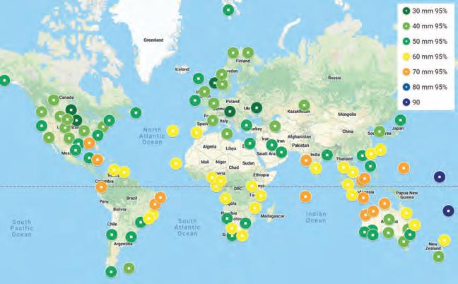
Figure 2: 95% height Marinestar accuracy in January 2022 for G2+.
at around 130 places in the world. The global 95% height position performance is shown on the world map below for January 2022.
As can be seen, the 95% height accuracy is around 5cm in Europe, northern Asia, Chile, Argentina and southern Australia. In the equatorial zone, tropical rain reduces the results to 6–7cm, and accuracy is slightly more than 10cm over the Pacific Ocean. Dynamic accuracy is at the same level as the above static results.
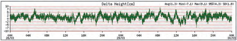
STATIC POSITION OVER TIME
Figure 3 shows the static G4+ position results in the Netherlands using a Septentrio M3 receiver.
The standard deviation of the height is 1.9cm, and 95% of the height measurements are within 4.3cm. The horizontal offset is within 1.9cm for 95% of the positions. On average, 32 GNSS satellites were used.
THE VALUE OF “+”
Plus is used if at least one GNSS satellite has its integer number of wavelengths fixed, which improves the position accuracy to the centimetre level. Using one year of global “+” data improved the 95% height accuracy by 1cm. The “+” corrections also remove small residual orbit and clock errors.
IMPROVEMENTS USING FOUR CONSTELLATIONS
Using four GNSS constellations (GPS, Galileo, BeiDou and Glonass) has several advantages over using single or dual satellite constellations for the Marinestar service.
GPS
GPS typically has 31 useable satellites around the globe. In January 2020, G11,
G22 and G28 were unavailable, reducing the minimum number of available satellites temporarily to 28. For users in the field, the minimum number of available GPS satellites in this period was six. This is close to the minimum number of four satellites for GPS-only Marinestar positioning.
BeiDou3
BeiDou3 has 42 healthy satellites using the B1 and B3 frequencies. BeiDou inclined and geostationary satellites at 36,000km are accurate to the metre level and provide support when going under bridges or during short periods of radio interference. There are around 27 useable BeiDou satellites over China and between 7 and 12 over the Americas.
Galileo
Galileo typically has four to nine satellites available during the day worldwide. When E19 became unhealthy, this was reduced to a minimum of just three useable Galileo satellites in parts of the world. The December-launched E10 and E34 will soon become healthy, improving Galileo satellite availability. The accuracy level of orbit and clocks offsets is in the same order as for GPS.
Glonass
Glonass currently has 24 satellites, but R6, R10 and R23 (no L2) and R11 and R16 (unhealthy) are currently unavailable, reducing the number of useable Glonass satellites to just two during short periods of the day. Glonass orbit and clock offsets are in the order of three times less accurate than for GPS and Galileo.
It is clear that all four constellations (G4) increase availability. In general, there are between 25 and 40 GNSS satellites available for Fugro Marinestar positioning. Using four constellations also helps in the following cases:
• Blockage of the sky
If a survey vessel needs to map the sea bottom of a harbour near quays where large ships are moored, a large part of the sky can be blocked. More GNSS satellites increases the ability to continue precise positioning.
• Radio interference
Radio interference can be due to local Figure 3: Two-day height offset for 28–30 March 2022.
electronic devices accidentally transmitting at higher harmonics in the GNSS bands. Also, GPS L1 Jammers are quite common. In large parts of the world, amateur radios can use the 1,240–1,300MHz band, interfering with Glonass L2, BeiDou B3 and Galileo E6. Iridium and Globalstar at 1,602MHz can interfere with Glonass L1 and GPS L1 if the GNSS antenna has no bandwidth protection.
• Scintillation
During ionospheric storms, the ions in parts of the upper atmosphere can move so fast that tracking of GNSS signals gets difficult. This is called scintillation.
Scintillation around the equator – in particular near Brazil – and in the Arctic regions reduces the number of useable satellites in parts of the sky. Having more
GNSS satellites helps to overcome resets and reduce position noise, especially as solar activity increases to a solar maximum in around 2025.
AUTOMATIC L-BAND BEAM SELECTION
The AsteRx-Marine M3 with the Marinestar service tracks four correction beams over L-band and two internet NTRIP (Networked Transport of RTCM via Internet Protocol) correction streams. In many places in the world, there are two (Americas, India, Asia, Australia) to four (Europe, Africa, Middle East) L-band satellites visible. The receiver automatically selects the best available correction beam.
BRIDGING GAPS
A test was carried out by driving slowly 14 times backwards and forwards underneath a bridge to establish the time required to recover to original accuracy. If MarinestarG4+ loses lock on all GNSS satellites, for example when passing under a bridge or with heavy GNSS L1 radio interference, the receiver can acquire the original position accuracy within 8–10 seconds after passing the bridge. The maximum period without GNSS measurements after which the position can be restored is more than one minute.
CONCLUSIONS
• Vertical and horizontal accuracies for the Marinestar service are better than 5cm (95%). • During bridging periods without GNSS measurements, Marinestar is capable of acquiring the original position accuracy within 8–10 seconds. • Multiple L-band/NTRIP input increases the robustness and availability of corrections, while using more GNSS satellites improves the accuracy and robustness of the position solution.
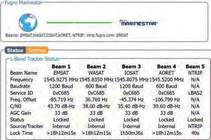
Figure 4: AsteRx-M3 Marine tracking four L-band beams and NTRIP in parallel.
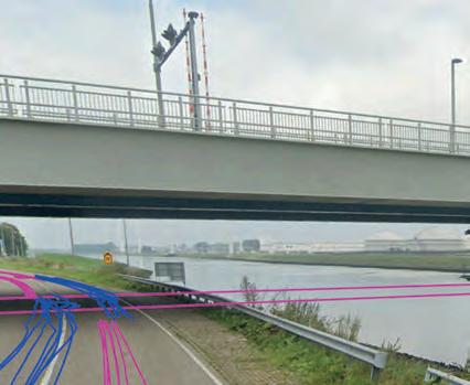
Figure 5: Test passing a bridge 14 times. Purple is Marinestar, blue is standard GNSS.


