
19 minute read
Development of Digital Bathymetric Models from Hydroacoustic and Photogrammetric Data
Geoinformatic Techniques to Combine Bathymetric Data for Shallow and Ultra-shallow Waters
Development of Digital Bathymetric Models from Hydroacoustic and Photogrammetric Data
Unmanned vehicles, both surface and airborne, are increasingly being used for hydrographic surveying. While the technology of data acquisition using these platforms is generally known, the fusion of this data is still the subject of much research, and the methods applied often depend on the sensors used and the properties of the survey area. This study presents a method for fusing data acquired using unmanned surface vehicle (USV) and unmanned aerial vehicle (UAV) measurement platforms to develop a digital bathymetric model. The case analysed concerns shallow water and ultra-shallow water up to the boundary with the shoreline.
APPROACHES FOR COMBINING BATHYMETRIC DATA
Various methods are currently used to acquire bathymetric data, including hydrographic methods using hydroacoustic sensors at the water level or below, and remote sensing methods from an aerial platform or satellite. Traditional hydrographic methods include a wide range of survey techniques, ranging from survey poles through single beam echosounders (SBES) to advanced hydroacoustic techniques such as multibeam echosounders (MBES). Remote sensing methods involve the processing of multispectral aerial and satellite images and bathymetric Lidar (Light Detection and Ranging) measurements. It is worth noting that USVs are increasingly being used for many surveying techniques, with the key advantage that they reduce the workload for operators and make it possible to carry out measurements in shallow and restricted waters. UAVs, on the other hand, can be used both as a photogrammetric as well as a Lidar platform. There are also hybrid solutions that enable the acquisition of bathymetry using an echosounder towed by a low-flying UAV or an integrated ground penetrating radar (GPR). Many solutions for hydrographic surveys using USV-based platforms are also increasingly used. Each of these methods has its limitations and works best in different conditions and types of water bodies. In the case of hydroacoustic surveys, the main constraint is the depth of the water, to allow safe passage of the hydrographic unit, while in the case of remote sensing the parameters of the water and the water body are the main concern, such as water transparency, water depth or bottom type. For this reason, data from different sources is often combined in a
Figure 1: USV used in the research.
fusion process to produce an integrated bathymetric model covering the entire survey area. Two special areas when it comes to the use of photogrammetry and remote sensing are shallow and ultra-shallow waters, which are usually inaccessible to hydrographic survey units. For effective measurement in these waters, hydrographic and photogrammetric methods must be combined. Unfortunately, different datasets acquired with different sensors have different ranges and structures, related to the density of the points, their quantity or spatial distribution and the measurement errors. The proper integration of data therefore requires the development of dedicated techniques.
DATA ACQUISITION IN SHALLOW WATER
This case concerns data acquired by UAVs and USVs. The study area is part of Lake Dabie, in Poland, and includes a small bay with a beach. The area of the investigated region is 2.71ha and the bottom of the water area is mostly fl at, with more depression at the entrance to the bay. The average depth of the studied area is about 1m and the maximum depth is 3.95m. Photogrammetric data was acquired with a DJI Phantom Pro surveying platform, using a classical approach with ground control points (GCPs) established on the lake bottom. During image processing, datasets with a density of up to 300 points per square metre with a scattered distribution were obtained. The advantage of this method was the possibility to acquire bathymetric data from the shoreline, through the ultra-shallow to the shallow water. The ultra-shallow water zone is particularly important because, when creating a digital bathymetric model of this area, the lack of bathymetric data cannot always be compensated for using interpolation methods. Previous studies have indicated that doing this results in a much higher compilation error. Unfortunately, due to poor water transparency, it was effectively possible to only acquire data to a depth of 1.3m using photogrammetric methods. It should be noted here that, for inland waters, depth measurements are in many cases only possible to a depth of 1.6–2m, even using Lidar bathymetric sensors. A natural complement to bathymetric data for greater depths is data acquired by hydroacoustic methods. For this purpose, a USV with an SBES sensor was used (see Figure 1).
The survey was performed on planned profi les at intervals of 10m. In the profi le, data was acquired approximately 0.3–0.4m apart. The acquired data was processed to improve the quality by analysing individual echograms and selected depths. The advantage of this type of survey is that it is possible to obtain accurate correction data in a single profi le and measurements at greater depths. On the other hand, the disadvantage is the inability to survey ultra-shallow depths or areas with navigational hazards (submerged vegetation, branches of submerged trees, fi shing nets, etc.). The survey area together with the measurement platforms is illustrated in Figure 2.
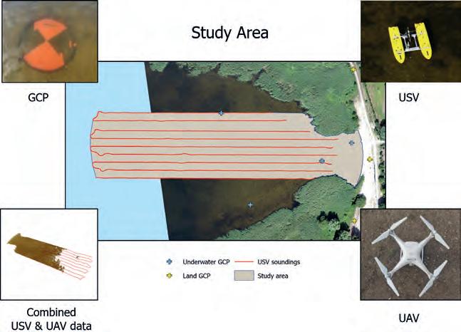
Figure 2: Map of the study area and USV soundings shown against the background of the generated UAV orthomosaic and pictures of survey platforms used; in the upper left corner a photo of an underwater GCP used in the photogrammetric data elaboration.
Figure 3: Generalized geoprocessing scheme.
GEOPROCESSING METHOD
The data fusion approach uses geoinformatic data processing methods and was developed based on the research methodology described in the article listed in the reference. The main element of this process is the concept of a bathymetric reference surface on the basis of which a selection is made of post-processed depth data acquired from UAVs. An uncertainty of 25cm was taken as the threshold for acceptable deviations from the bathymetric reference surface. This means that all points within this deviation tolerance were retained. The fi nal processing of the data was preceded by tests to select the appropriate data fi lter mask, point cloud type and interpolation method. A generalized diagram of the geoprocessing with examples of data is shown in Figure 3.
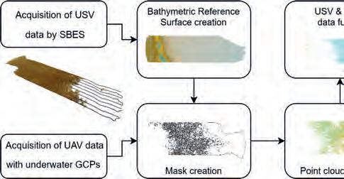
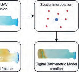
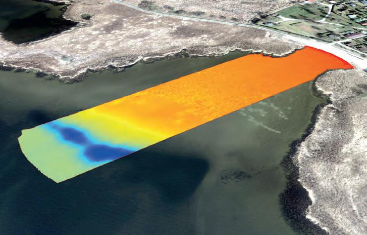
Figure 4: The developed hybrid bathymetric model from USV and UAV data.
As the acquisition and processing of the SBES sensor data took place in accordance with the hydrographic methodology used, more attention was paid to the UAV data. During the experiment, photogrammetric data was processed using the traditional method, but with a GCP network established underwater. This approach does not take into account refraction of the electromagnetic wave in water, unlike most of the methods that use passive remote sensing. Additionally, two types of UAV point cloud were analysed. The fi rst was a full cloud, including all point classes, while the second was a ground class cloud. The universal mask for fi ltering the points was developed on the basis of deviations from the bathymetric reference
surface with respect to maximum and minimum values. In the fi nal step, a qualitative and quantitative analysis of the different interpolation methods by which a digital bathymetric model can be developed was carried out. The analysis indicates that the best results for developing the fi nal product were obtained using a UAV point cloud developed from a ground class cloud. Unfortunately, not all interpolation methods performed well on the data structure consisting of USV profi les and a UAV cloud, such as the Radial Basis Function (RBF) method. The adopted digital bathymetric model (DBM) data processing can be developed using methods such as triangulation, nearest neighbour, kriging or inverse distance to a power, which gives comparable results in terms of accuracy of the reconstructed surface. The developed hybrid bathymetric model is illustrated in Figure 4.
CONCLUSIONS
The experiment shows that it is possible to develop a data fusion method and a fi nal bathymetric model based on the proposed geoinformatics data processing for shallow and ultra-shallow water areas. This includes UAV
point cloud generation, point fi ltering using masks and the use of spatial interpolation methods. The essential elements of the proposed method include the acquisition of bathymetric data using a classical photogrammetric approach; in other words, the use of an underwater GCP network, the application of a ground class UAV point cloud and the use of selected interpolation methods. An additional important element of the method is
the processing of UAV data based on a bathymetric reference surface. The proposed method certainly simplifi es the development of bathymetric data by not taking refraction into account, but its limitations must also be considered. These include an applicability to small areas and the necessity of establishing an underwater photogrammetric network. As photogrammetric methods are formally one of the sources of bathymetric data acquisition, any research that assesses the practical applicability of this type of data and its processing methods is valuable.
References
Lubczonek, J.; Kazimierski, W.; Zaniewicz, G.; Lacka, M. Methodology for Combining Data Acquired by Unmanned Surface and Aerial Vehicles to Create Digital Bathymetric Models in Shallow and Ultra-Shallow Waters. Remote Sens. 2022, 14, 105. https://doi.org/10.3390/rs14010105 Lubczonek, J.; Wlodarczyk-Sielicka, M.; Lacka, M.; Zaniewicz, G. Methodology for Developing a Combined Bathymetric and Topographic Surface Model Using Interpolation and Geodata Reduction Techniques. Remote Sens. 2021, 13, 4427. https://doi.org/10.3390/rs13214427 Manual on Hydrography. International Hydrographic Organization., IHO C-13. 2011
About the authors
Jacek Łubczonek conducts research on hydrographic and topographic data processing using geoinformatics techniques and artifi cial intelligence methods at the Maritime University of Szczecin, Poland. He received a PhD in geodesy and cartography in 2003.
Witold Kazimierski, navigator and GIS specialist, received a PhD in geodesy and cartography in 2008. He is currently an associate professor at the Maritime University of Szczecin, Poland, and focuses in his research on target tracking, data fusion, spatial analysis and USV navigation, also using AI.
Grzegorz Zaniewicz, hydrographic surveyor, received an MSc in Navigation from the Maritime University of Szczecin (MUS), Poland in 2009. He has been employed as a research assistant at MUS since 2011, where he has taken part in many R&D projects related to geoinformatics and hydrography. His main scientifi c interests include hydrography, underwater data acquisition and processing.
Seagate’s Lyve Mobile Mass Storage and Data Transfer Solution Gives the Geosciences Industry a New Option to “Bring Data Home Safe”
Geoscience survey companies face a constant challenge in securing and moving data. Operating in far-fl ung, barely connected parts of the world, with temperatures and weather hard to predict, they deploy scanning and sensor technologies that can generate gigabytes of data in a single shift, and terabytes every few days. Storing such massive amounts of data in the fi eld (or on an ocean vessel) and moving large datasets quickly and reliably to a cloud or on-premises processing centre present tough dilemmas.
Understanding that data expansion will continue in the foreseeable future, Seagate has introduced Lyve Mobile Edge Storage
and Data Transfer Service.
With its fl eet of Lyve Mobile™ data shuttles and arrays, Lyve Mobile enables geoscience businesses to move mass data quickly, securely and simply. Scalable, modular and vendor agnostic, this storage solution eliminates network dependencies so that companies can transfer mass datasets in a fast, secure and effi cient manner, making sure no time is wasted waiting for data to upload.
A conversation with Nir Elron, Seagate’s director of global commercial activities for Lyve Mobile, and Darren Biggs, geoscience services manager at ET Works.
Seagate is rolling out Lyve Mobile fi rst to industries that generate a lot of data. That certainly applies to hydrography and oceanography.
N.E.: Today, everything needs to be digitized and done quickly. Everybody’s running in the same race, trying to map their terrains or the ocean fl oor quicker than the competition. Seagate is the single largest

Managing high data volumes at sea
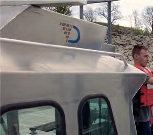
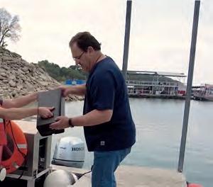
Terradepth, based in Austin, Texas, was an early adopter of Lyve Mobile. The company needed a data transfer solution that could withstand environmental extremes, and easily connect to their autonomous surface and subsurface vessels (AxVs). At the end of a mission, the accumulated data is retrieved from the AxVs via a cable connection and saved to 96-terabyte Lyve Mobile arrays. The edge-collected data is then transferred in bulk to an on-premises cloud access point. (Image courtesy: Terradepth)
storage vendor in the world in terms of sheer media capacity. We make and deploy more than 600 million terabytes of storage solutions every year. Almost half the data in the world is stored on our devices. Over the last few years, we’ve added another leg to the business. Instead of just ‘make and sell’, we now also ‘make and deploy as a service’. That is Lyve Mobile (pronounced as in ‘alive’). It is a subscription-based service, so customers can scale up or scale down according to their present needs.
HOW DOES LYVE MOBILE WORK?
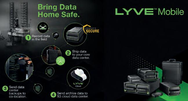
N.E.: Lyve Mobile resolves technical issues around data acquisition and movement for customers. It doesn’t matter if it’s an oil rig or ship, or a vehicle on land that is performing seismic surveys. The data is recorded in the fi eld on mobile arrays. These are Seagate’s highest grade, enterprise self-encrypted drives (SED), meaning that every bit copied onto the array is encrypted. The encryption keys are manged by our clients, providing access to the data stored on the arrays only to their trusted targets. The mobile arrays are totally host agnostic and cloud agnostic, with a capacity of up to 100 terabytes per unit. It’s about a shoebox in terms of size. You can connect these devices in the fi eld to any kind of host, any kind of streamer, any kind of sensor you want to record. At the end of the session – every day, every week, every month, every six months, depending on the cycles of moving the data from the endpoint to the cloud – the mobile arrays are put in a Peli case. It is then the customer who decides what to do next. One option is to leverage our logistics services, meaning that we deliver the data
wherever it needs to go via our extremely well-established logistics networks. Seagate manufactures and ships around a half a million devices every day.
NEXT-DAY DELIVERY
D.B.: It’s effectively like leasing data storage and mobility solutions. For every project, you have the latest version. In the Lyve Management Portal, users can set up their project scope and data storage requirements. In most cases, their caddies arrive the following day, ready to be plugged into the vessel. If you need more, you add more. If you need less, you take less. You get the exact components you need. You use them for the life of the project, then they go back to Seagate and get refreshed and updated. So you’re always going to have the latest generation. N.E.: You might have a burst where you suddenly need to move 5 terabytes or 50 terabytes every day, or you might have a 500-terabyte event that you need to move and ingest. Within 24 hours, we get you what you need to move it. That’s the kind of fl exibility we’re offering. D.B.: With Lyve Mobile we can scale up to the petabyte level, which is necessary for a lot of oceanographic data. But equally, Seagate has ingestion points at key locations globally. These are on 100 gigabyte lines, which then talk to the Seagate Lyve cloud environment. An ecosystem is the best way of describing it.
BYPASSING PUBLIC NETWORKS’ VULNERABILITIES
N.E.: There’s a mentality today that every dataset can go over 4G or 5G networks, or
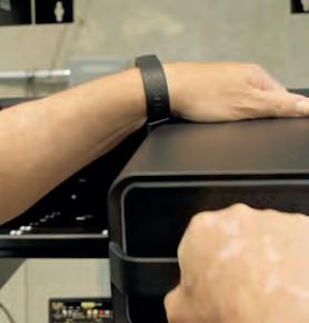
The mobile arrays fi t into the Rackmount Receiver. Once devices are active, the included client software allows you to customize your settings and create copy workfl ows. (Image courtesy: Terradepth)

over fi xed landlines. But when we’re talking about terabytes of data, there’s no way to move tens of terabytes daily using networks. You need to physically perform some sort of forklifting, moving data from point A to another point, then ingest it to a trusted target, whatever that may be. Security is also an issue. Data is very vulnerable if you try moving it using public networks. With Lyve Mobile, all data copied onto an array is ‘encrypted at rest’. That is by defi nition more secure and less costly compared to ‘encryption in transit’. With our encryption and built-in security elements, the mobile arrays become like a data vault.
GEOSCIENCE USE CASES
N.E.: We see upstream use cases around exploration and drilling, activities like site mapping, offshore modelling, geophysical surveys, seismic surveys, environmental and drilling monitoring and acoustic sensing. These generate tens and in some cases hundreds of terabytes every day. Midstream, too, in production and transport, there is a need to acquire a lot of data and move data quickly. Offshore pipe performance monitoring, for example. It all uses high-fi delity, high-resolution sensors. Those sensors are storage hungry, and their resolution keeps growing.
D.B.: ET Works serves clients in oil and gas, but also in offshore wind and renewables, all of which use offshore data. For our acquisition and processing clients also, storage is a big concern. Seagate came to us with the Lyve portfolio for edge data storage, high-speed, ruggedized, large datasets where you can’t transfer the data over the wire or over cloud or over satellite. We said yes, this looks very exciting.
N.E.: Everything with the ‘Lyve’ label is made by Seagate and offered to customers as a service. It is part of a general evolution within the company, and globally. It lets customers shift costs for data storage and movement from capital expenditures to operating expenses. That dramatically reduces any capital expense barriers for customers.
D.B.: Because of the cyclical nature of the oil and gas industry, it helps if you can expand and contract your project portfolio as needed. Many companies have moved away from owning even the vessels. Seagate’s Lyve Mobile is well aligned to that because it’s next-day delivery.
For more use cases and to learn what Lyve Mobile can do for you, please visit www.seagate.com/products/data-transport
Innovations and Partnerships in Ocean Mapping: What More Could We Achieve?
Most people working in hydrography know very well that better ocean data can be used to inform a variety of decisions, from storm preparedness to helping develop the blue economy. But could we do more in terms of fostering innovations or partnerships within our network? Could we do more with our existing partners?
These questions are prompted by a review of some of the work being done within the IHO. We initiated this year for example a trial project with CSIRO in Australia, funded by the Australian Hydrographic Office, to see whether accurate and reliable depth data can be extracted from Argo recordings. Argo is an international programme that collects information on the ocean using a fleet of robotic instruments that drift with the ocean currents and move up and down the water column. During deployment, Argo floats often touch the sea floor and record when this happens. Of the 2.7 million data profiles collected, initial analysis shows that up to 8% of these could be groundings, which could potentially reveal 216,000 new depth measurements from around the world. The trial has already provided new data in the Norwegian Sea and in New Zealand, with an excellent median accuracy of 7 or 8m. Considering there are currently 3,959 Argo floats operating across the globe, this could open the door to valuable new data.
Another innovation recently released by a consortium made up of The Nippon Foundation-GEBCO Seabed 2030 Project and Seatrec could also have an impact: this is a thermally recharging float equipped with an echosounder. This float, which is the first of its kind specifically designed for bathymetry, will be tested to map the area in the ocean near Point Nemo, the point furthest from land. This remote oceanic location is located about 2,688 kilometres from the nearest land – Ducie Island, in the Pitcairn Islands to the north, Motu Nui, one of the Easter Islands, to the north-east and Maher Island, in Antarctica, to the south.
The initial results of our cooperation with Argo look promising, and I sometimes ask myself, why didn’t we think of this sooner?
Argo floats provide information on parameters such as temperature and salinity throughout the water column. This sheds light on the ‘real’ temperature profile of the ocean at different depths, as opposed to just the surface. This information is important for many disciplines, including storm predictions, as storms and hurricanes are powered by heat stored in the ocean. The more heat, the more powerful the storm. This data can enable communities to be better prepared for such events. It would be interesting to see in the coming months if this work could be adapted to the latest generation of Argo floats, known as Deep Argo, which can go to depths of up to 6,000m and are equipped with multiple sensors to track the ocean’s chemistry and plankton ecology.
But what else could we do with this data? How could hydrographic offices participate more actively in such discussions? How could we get more data? As we all know, we currently only have high-quality maps for about 20% of the ocean. If we want to increase this number, we need to start thinking out of the box and looking at the big picture. In which areas on the seabed mapping data value chain are there gaps? How can we work collectively to address challenges? What innovations in other disciplines could be used by hydrographic offices?
We are going to be looking into the value chain in more detail at the IHO in the coming months, and hope to pinpoint some of the gaps and highlight some opportunities. More to come on this topic…
Mathias Jonas, Secretary-General, IHO.


