14 minute read
Bathymetry from UAV Imagery and Machine Learning

Improving Results with Refraction Corrections
Bathymetry from UAV Imagery and Machine Learning
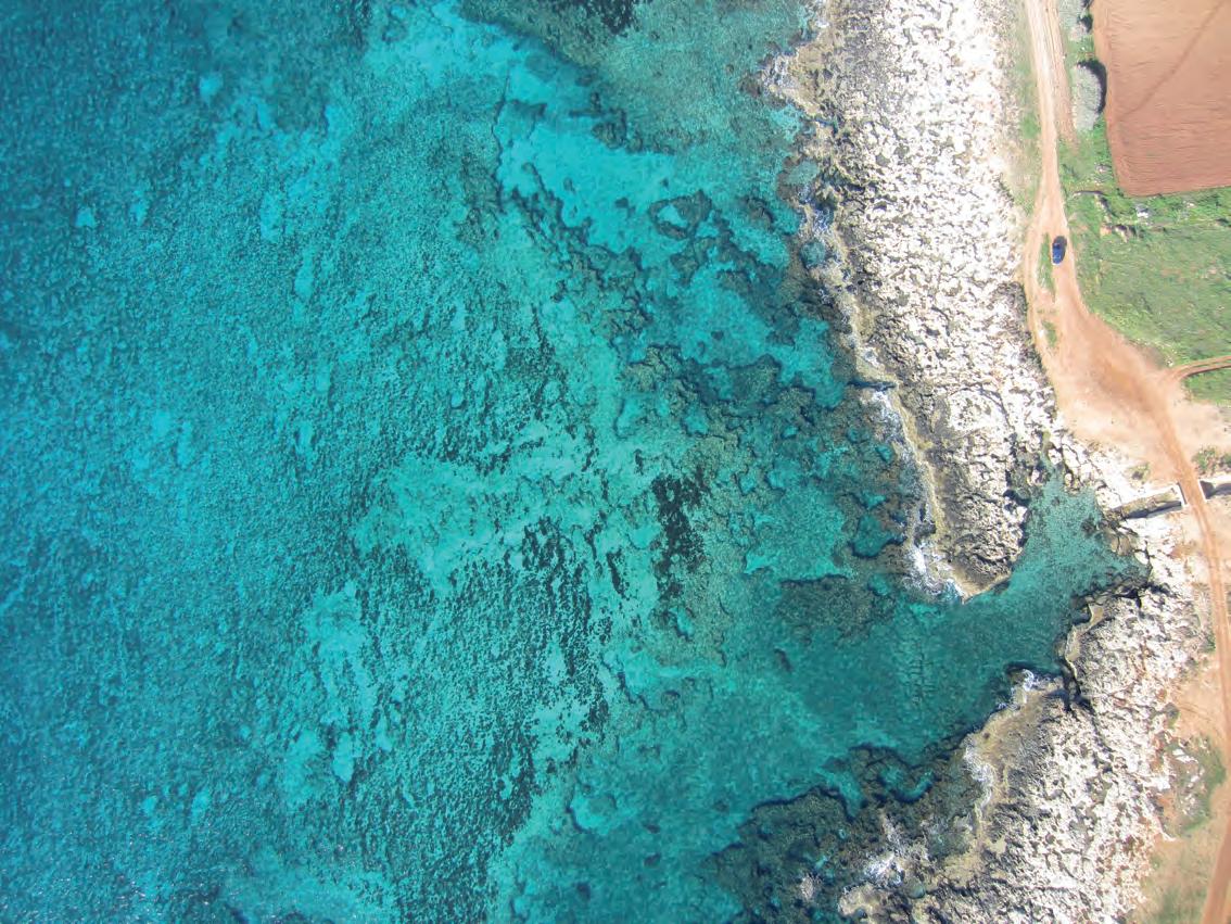
Accurate bathymetric mapping of shallow areas is essential for a plethora of offshore activities. Using Structure from Motion (SfM) and Multiview Stereo (MVS) techniques, images can provide a low-cost alternative compared to Lidar and sonar systems while also offering important visual information. This article presents a new framework for mapping the seabed in clear and calm shallow waters for small- and large-scale surveys using aerial imagery and machine learning to correct the geometric effects of refraction on the 3D point clouds and the imagery.
SfM is a photogrammetric technique for estimating 3D structures from 2D image sequences. It involves acquiring images from several positions relative to the object of interest. To establish the spatial relationships between the camera positions, features appearing in multiple images are identified automatically. Then, a self-calibrating bundle adjustment is used to calibrate the cameras and derive a sparse 3D point cloud to represent the object. External geometric constraints can also be applied to transform the 3D data to a desired coordinate system. MVS techniques are used to generate a very high-resolution 3D point cloud. MVS algorithms can construct highly detailed depth maps and consequently 3D point clouds that exploit the stereo correspondence of more than two images. Most commercial photogrammetric software currently delivers 3D point clouds by combining these two techniques.
image-based bathymetric maPPing and refraction effect
Compared to onshore aerial mapping, bathymetry mapping from aerial platforms in shallow waters is considered a much more time-consuming process. This is mainly due to the necessary compensation of refraction effects, which affect the geometry and radiometry of the primary data and consequently of the results by delivering apparent depths, as aerial imagery depicting the bottom of water bodies is heavily affected by the refraction of the optical rays. Refraction acts on these images similarly to the radial distortion, differing practically at each pixel of every image, leading to unstable solutions and erroneous depths. More specifically: according to Snell’s law, the refraction of a light beam is affected by water depth and the angle of incidence of the beam in the air/water interface. The problem becomes even more complex when multiview geometry is applied, as the 3D position is derived from multiple images and thus from multiple refraction sources.
In shallower, clear water areas, and when refraction effects are successfully treated, bathymetry mapping from aerial platforms is a more efficient operation than ship-borne echo-sounding or underwater photogrammetric methods. A very important additional feature of image-based seabed mapping is that a permanent record of other features is obtained in the coastal region, such as approximate tidal levels from the waterline markings showing in the images, coastal dunes, benthic communities, marine litter, rock platforms, and beach erosion when results are compared with archival data. These benefits are especially evident in the coastal zones of up to 15–20m depth, in which most economic activities are concentrated.
The presented framework developed by our team at the National Technical University of Athens and the Cyprus University of Technology corrects the refraction effect on the 3D point clouds and the aerial images of the bottom in two complementary modules. The first module corrects the apparent depths of the 3D points generated by the SfM-MVS methods and can also be used stand-alone. In that case, only a 3D point cloud, a 3D mesh, or their derivates such as depth contours, result. The second module transfers this correction to the image space, correcting the effects of refraction on the aerial imagery. The restriction on the framework is that there should be a calm water surface, non-turbid waters, and a textured seabed. More details for each module of the framework are given below.
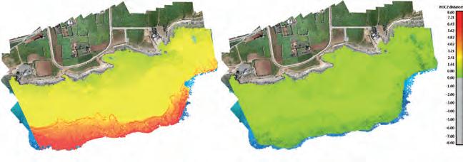
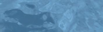
Difference between bathymetric Lidar point cloud and the uncorrected imagery (left) and the difference using corrected imagery from the presented framework (right).
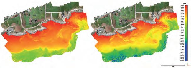
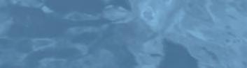
Seabed point cloud depths (Coord. Z) before (left) and after (right) the applied machine learning correction on the 3D point clouds. Points on dry land remain untouched.
correcting the aPParent dePths of 3d Point clouds
To correct the apparent depths of 3D point clouds of the bottom of water bodies which are derived by SfM-MVS processing of low-altitude aerial imagery, a linear support vector regression model was trained. In machine learning, support vector machines are supervised learning models that analyse data used for classification and regression analysis. This model was trained on synthetic and real-world data to learn to predict the correct depths, knowing only the apparent (erroneous) depths derived from the photogrammetric process. The model can generalize over different UAV systems, cameras and flying heights, regardless of the area to be mapped. This module delivers 3D point clouds of the seabed with the corrected depths.
To correct the geometric effects of refraction on the low-altitude aerial imagery, a state-of-the-art image correction method has been developed which builds on and exceeds earlier methods developed by our team. This module follows the first one and corrects the refraction effect on the original imaging dataset. This correction can be briefly described as a sophisticated reduction of the radial distance of each pixel, according to the depth and the incidence angle of the beam in the air/water interface. This module delivers refraction-free images that can be used directly with photogrammetric SfM and MVS processing pipelines, resulting in highly accurate bathymetric maps and image-based products.
results in real-world aPPlications
The method was tested through experimental results and validation over three synthetic and five different real-world cases in Greece and Cyprus with flying altitudes ranging from 35–210m. To evaluate the results of the framework, the initial (uncorrected) 3D point clouds of the SfM-MVS procedure and the point clouds resulting from the presented framework were compared with bathymetric Lidar point clouds and total station measurements available for the areas. An example is given where the depth differences between the Lidar data and the uncorrected image-based point clouds are presented. This comparison makes clear that the refraction effect cannot be ignored in such applications. In the presented case, the Gaussian mean of all the differences is significant, reaching 2.23m (RMSE 2.28m) in the test site. Since these values might be considered negligible in some applications, it is important to stress that more than 30% of the compared uncorrected image-based depths represent a difference of 3.00–6.07m from the Lidar points, or 20–41.1% of the real depth.
By applying the presented framework and correcting the refraction effects, a more than 97.3% reduction in the remaining vertical RMSE of the depths of all the sites was achieved. In some cases, the initial vertical RMSE of 3.34m, mean of 2.96m and standard deviation of 1.54m of the uncorrected data were reduced to 0.09m, 0.02m and 0.09m respectively after the refraction correction, while in other cases the initial vertical RMSE of 2.28m, mean of 1.71m and standard deviation of 1.18m were reduced to 0.13m, 0.04m and 0.12m respectively. In the same cases, the most popular state-of-the-art solution achieved a reduction of the vertical RMSE to 0.52m and 0.45m respectively, indicating that the new framework presented here outperforms current methods. By examining specific points instead of all the test sites, it was observed that, in some cases, the initial vertical difference from the Lidar data of 5.10m was reduced to 0.05m at the depth of 14.20m.
It is also important to note that the second module achieves a reduction in the noise of the sparse point clouds, which resulted from the SfM process and improved the accuracy and the quality of the resulting orthoimages and textures. This module also increased the resulting accuracy of the state-of-the-art method fivefold, extending the operating depths from 7.50m to 15–20m.
conclusion
The framework developed and presented proves that through-water photogrammetry can deliver accurate bathymetric information in clear and calm waters with textured seabeds. What is required is that refraction is addressed thoroughly. Contrary to the current state-ofthe-art methods, the presented framework is designed to achieve high generalization, expanding the applicability of and boosting SfM-MVS techniques for aerial bottom mapping. It delivers highly accurate and detailed bathymetric maps and image products, satisfying the International Hydrographic Organization’s S44 Special Order TVU of 0.29m at 20m depth at the 95% confidence level. The implementation of the framework on UAV images facilitates the detailed and accurate monitoring and mapping of the sensitive coastal area. Moreover, it supports low-cost mapping strategies and enables a wide usage of UAV imagery in shallow clear and calm waters instead of more expensive Lidar and sonar systems, increasing the amount of information.
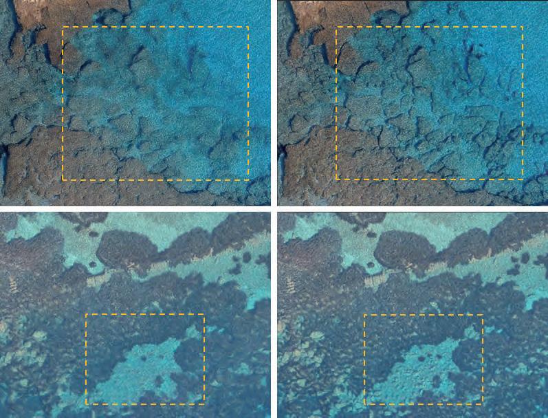
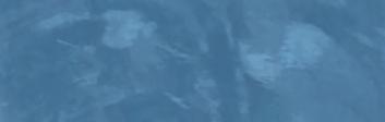
3D models’ textures generated with the original (left) and corrected (right) for refraction imagery.
Further Reading
- Correcting Image Refraction: Towards Accurate Aerial Image-Based Bathymetry Mapping in Shallow Waters: www. mdpi.com/2072-4292/12/2/322
- DepthLearn: Learning to Correct the Refraction on Point Clouds Derived from Aerial Imagery for Accurate Dense Shallow Water Bathymetry Based on SVMs - Fusion with LiDAR Point Clouds. www.mdpi.com/2072-4292/11/19/2225
- Shallow Water Bathymetry Mapping from UAV Imagery Based on Machine Learning. https://www.int-archphotogramm-remote-sens-spatial-inf-sci.net/ XLII-2-W10/9/2019/
- A Novel Iterative Water Refraction Correction Algorithm for Use in Structure from Motion Photogrammetric Pipeline: www.mdpi.com/2077-1312/6/3/77
Panagiotis Agrafiotis holds a doctorate in Engineering from the National Technical University of Athens as well as an MSc in Geoinformatics and an MEng diploma in Surveying Engineering. His current research focuses on image-based bathymetry mapping for shallow and deep waters using photogrammetry and machine learning techniques. His expertise includes 3D computer vision, remote sensing and machine learning. During the past 8 years, he has worked on more than 16 research projects as a member of the Lab of Photogrammetry of NTUA, the Photogrammetric Vision Lab of CUT and the Institute of Communication and Computer Systems of NTUA. He also serves as the secretary of the ISPRS WG II/9: Underwater Data Acquisition and Processing. pagraf@central.ntua.gr
www.blueprintsubsea.com sound by design
Multibeam Imaging Sonars
Single and Dual Frequency Operation 300m and 4000m Depth Rated
Micro-USBL Tracking Beacons
Bidirectional Acoustic Data Modems
Portable Sidescan Sonars
Towed, OEM, Hull and Pole Mounted
find out more www.blueprintsubsea.com
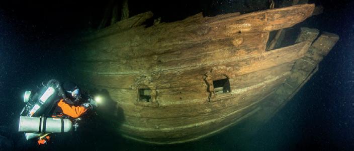
Finnish Diving Team Discovers Rare Wreck of 17th-century Dutch Merchant Ship
While undertaking documentation dives on some supposedly World War I or II wrecks at the mouth of the Gulf of Finland, Badewanne divers descended on one of the biggest surprises during their long careers of diving the wrecks of this eastern extension of the Baltic Sea. The Baltic Sea has been an important trade route since the Middle Ages, as the navies of Holland and England needed endless supplies of wood, tar and hemp, all of which were available around the Baltic. From the 13th century onwards, the Hanseatic League controlled the trade, but during the 17th century the very effi cient merchant navy of the Dutch Republic gained control. The trade route received a signifi cant boost in importance and profi tability after Tsar Peter the Great founded his new capital St. Petersburg at the estuary of the Neva River, in the easternmost part of the Gulf of Finland.
https://bit.ly/2GL8DNO
Port side hull view of the stern of the fl uyt shipwreck. Decorated stern cabin portholes are visible. (Image Courtesy: Badewanne)
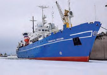
Russian Survey Vessel Explores 14,000km Cable Route across Arctic Seabed
On 6 August 2020, the Professor Logachev survey ship set out from Kirkenes, Norway on course for Russian Arctic waters. Over the next three months, the ship and its crew will sail 6,500km along the north Russian coast. The Norwegian border town could become a hub for an almost 14,000km-long telecom cable between Asia and Europe. Researchers are this summer exploring the best route across the Arctic seabed. Their mission is to look into the Professor Logachev survey ship. (Image Courtesy: deep to examine the sea bottom. Their fi ndings Polar Marine Geosurvey Expedition, pmge.ru) will be crucial for the future of Arctic Connect, the project developed by the Finnish company Cinia together with Russia’s MegaFon. The cable connection between Kirkenes and Japan will bridge northern Europe with Russia, Japan and North America, and also meet growing needs in the Arctic region itself, project developers argue. It will have a transmission capacity of 200Tb/s, says MegaFon.
https://bit.ly/3leXjIU
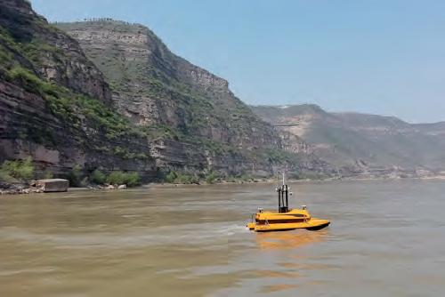
Unmanned Technology Narrows Data Gap of the World’s Most Sediment-laden River
With a total length of 5,464km, the Yellow River is the second-longest river in China. Its middle section runs through the Loess Plateau, where it picks up sand and dust, making it the most sediment-laden river in the world. Yellow River runs through nine Chinese cities and affects the daily lives of tens of thousands of people who live alongside the river. To better protect the ecology of the watershed, monitoring changes in the underwater terrain and studying the pattern of river evolution can provide important data to support river management and fl ood control. However, technical limitations and harsh environmental conditions mean that the Yellow River watershed has not yet been mapped accurately. The water system is complex, with rapid currents and many shallow areas, making it diffi cult to install survey equipment using traditional measurement methods and to fi nd a suitable workboat. Operations on the water also pose high risks to personnel.
https://bit.ly/3nnKJck
ME120 USV navigates autonomously to perform mapping task.
Teledyne CARIS AI Software Contributes to Successful UTAS USV Mission
Teledyne CARIS, a Teledyne Technologies company, was an integral part of the illustrious team involved in the ground-breaking uncrewed offshore survey mission in the Atlantic Ocean. Teledyne CARIS’ Mira AI and CARIS Onboard software were present on the vessel to enable autonomous survey and real-time processing operations. The mission’s Uncrewed Surface Vehicle (USV) built by SEA-KIT mapped over 1,000 sq. kms of the ocean fl oor in 22 days, while being continuously monitored via satellite communications at its Remote Operations Centre in Essex, United Kingdom. A specialized team comprised of the GEBCO-Nippon Foundation Alumni Team operated the survey equipment and provided quality control of the data from various ‘work-from-home locations’ around the world.
https://bit.ly/33wBGxN
The image displays initial results following a fully automated processing workfl ow. Final deliverable of the survey will be processed using CARIS HIPS and SIPS.
REDEFINING THE WAY THE WORLD WORKS AT SEA
Iver4 Next-Generation Unmanned Undersea
Industry-leading UUV technology featuring extended mission endurance, user-swappable payloads and a full sensor suite for the highest quality data. Get ready for something NEW. Visit Booth G601 at Oceanology International 2020 for our new product unveiling.
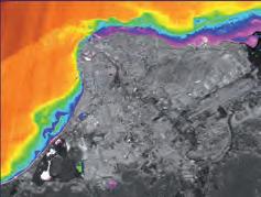
Venezuela Performs Bathymetric Surveys with Own Satellite
Ever since the launch of the VRSS-2 Antonio José de Sucre satellite in 2017, researchers have been looking into how best to use and apply the information that it provides for the benefit of environmental development and sustainability. For example, the bathymetry derived from Calculation of depths by applying satellite images is very beneficial for Multibeam imagery of the wreck of the long-lost the Stumpf algorithm, using the hydrographic services, since it allows German warship Karlsruhe. green, blue, red and infrared bands of information to be obtained that has not the satellite images. been explored with traditional acoustic methods. The Venezuela Hydrographic Office has started to use this method, also to improve its hydrographic coverage. The Antonio José de Sucre satellite is Venezuela’s third artificial satellite. It was launched from the Jiuquan Launch Center in Gansu Province, China and captures images for cartographic survey work, with a new high-definition camera and an infrared camera for soil, water resources diagnosis and seismological prevention data.
https://bit.ly/3jDLuvj
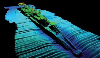
iSURVEY Helps Identify North Sea Shipwreck
During a recent offshore power cable cut and seal project on the Olympic Taurus, iSURVEY were part of the team tasked with identifying a shipwreck found three years previously during a routine inspection of the Skagerrak power cable. The wreck lies 13 nautical miles from Kristiansand in southern Norway, and was investigated using an ROV-mounted multibeam echosounder. Following the survey, it was determined that the wreck was that of the long-lost German warship Karlsruhe, famous for leading the assault on Kristiansand during the invasion of Norway in 1940. Until this discovery, Karlsruhe had remained the last World War II German warship whose whereabouts were unknown.
https://bit.ly/3jDC3Mz