


You make the impossible possible—going where others don’t want to go and achieving what others can’t. You lead the way in capturing and documenting the world around us with unparalleled accuracy and detail.
Push the boundaries of 3D laser scanning with powerful in-field automated registration, on-the-fly measurements, and annotations. Trimble® 3D laser scanning systems enable you to visualize and verify your projects before leaving the site, so you can capture complex real-world data with the confidence of getting it right the first time.
Find out more at: geospatial.trimble.com/3D-laser-scanning-solutions
Editor-in-Chief
Sanjay Kumar
Managing Editor
Prof. Arup Dasgupta
Deputy Executive Editor
Aditya Chaturvedi
India needs to assert its stand as a global space power carefully needing to navigate through geopolitical realities, technological advancements and strategic requirements, for that it needs to have a multi fronted approach.
Sr. Assistant Editor
Nibedita Mohanta
Sr. Sub Editors
Sachin Awana
Jeffy Jacob
Chief Designer
Subhash Kumar


/ Revolutionizing Multi-Domain

/ Geospatial Key to Indo Pacific

Visualizers
Pradeep Chauhan
Saurabh Srivastava
Circulation
Shweta Singh
Vijay Singh
18 / Focus on Ocean Mapping Key for Sustainability


Vinit Bansal & Gaurav Seth Co-founders, PierSight
24 / The New High Ground
Lieutenant General
Vinod G. Khandare, PVSM, AVSM, SM


Former Officer, the Indian Army; and Principal Adviser, Ministry of Defence
29 / Developing an Effective Space Strategy for India's Defence
/
30 / Geospatial Critical for Sri Lanka’s Defence
Major General SA Kulatunge, RWP, RSP, VSV, USP, PSC Sri Lanka Army

Dr Nithiyanandam
Head of the Takshashila Institution's Geospatial Research Program 14 / Innovative Tech and Business Models a Key for Earth Observation-as-a-Service
32 / AI and Geospatial based Crop Insurance
Dr. Siddhartha Khare
Founder, Bhoomicam Pvt. Ltd., & Assistant Professor, IIT Roorkee
39 / GeoInt & AI for Indo-Pacific Security


/ SAMUDRA App Benefitting
Vivek Saxena
Scientist-F and Team Lead for Enterprise GIS Software, Defence Geoinformatics Research Establishment (DGRE)-DRDO

/ Chenab Rail Bridge: A Geospatial and BIM Triumph
Disclaimer

Geospatial Artha does not necessarily subscribe to the views expressed in the publication. All views expressed in this issue are those of the contributors. Geospatial World is not responsible for any loss to anyone due to the information provided.
Owner, Publisher & Printer: Sanjay Kumar
Printed at All Time Offset Printers, F-406 Sector 63, Noida - 201 301, Noida (UP) India
Publication Address
A - 145, Sector - 63, Noida, India, Geospatial World: The edition contains 40 pages including cover.
Geospatial Media and Communications Pvt. Ltd.
A - 145, Sector - 63, Noida, India Tel + 91-120-4612500, Fax +91-120-4612555/666

Prof. Arup Dasgupta arup@geospatialworld.net Managing Editor
The Earth is known as the Blue Planet ever since its first images were snapped by Moon-bound astronauts. The oceans cover three fourth of the earth but are a poorly charted territory. We perhaps know more about the heliosphere than we know about our oceans. Our weather is largely affected by the ocean temperatures and currents. It acts as a sink for the excess carbon we produce. It has provided and continues to provide a means of exploration.
Space, and in particular, geospatial applications play a huge role in many areas. Meteorologists and oceanographers use space data for studying weather, climate and land-sea interactions. Ocean navigation uses GNSS satellites and ocean communications use satellites as well.
Space based geospatial data is also used to both enable and regulate fishing. It is also used to track rogue ships using ELINT and radar imaging.
Oceans do have another dimension. Nations who mastered the art of ship building and navigation could discover new places, establish trade and ultimately colonize these countries. This led to a situation where war moved into the seas. Large ships, ports, and other marine assets became vulnerable.
National security traditionally encompassed land, sea, and air. Today, space is being added to it. Space for strategic imaging, communications and navigation is already in place. Now it is formalized through the creation of military Space Commands in different countries. While these Commands are designed to establish Space Intelligence Surveillance and Reconnaissance (ISR) systems, the time is not far when they will also establish an offensive role. Weaponization of space is an unpleasant reality.
There are several regions of interest to ISR. For India the principal one is the Indian Ocean region. The Indian Ocean is a major transit route for commerce. Its western reaches are affected by piracy. It is also the playground for US, UK and China for espionage and surveillance. The Chinese presence in various ports like Djibouti, Hambantota, Maldives, Gwadar pose major concern in this region.
The Indian Ocean rim countries like eastern Africa, the islands, Iran, Pakistan, India, Sri Lanka, Bangladesh, Myanmar, Malaysia and Indonesia need to evolve a combined strategy for the protection of their assets and resources.
India with its mature space presence should be able to take a lead and provide the necessary wherewithal for each nation to set up its own security systems. The need is for standardization and interoperability at both the country and international levels.
Another theatre where India has more than a passing interest is the Indo-Pacific region. Much of the commercial traffic emanates from here as they pass through the Indian Ocean to points west. The maritime threat from China also emanates from here. Chinese espionage vessels are known to station themselves in the Indian Ocean to monitor civilian and military launches.
These regions do pose concerns but also provide opportunities for the deployment of space based ISR systems. For the private industry there are ample opportunities for marketing their offerings. Small satellites, smart sensors, launch systems and AI based analytics are some of the possible areas.
The blue in the Blue Planet poses threats and therefore opportunities. Carpe diem.
Pan India CORS Network is being established by Survey of India, to achieve centimetre level accuracy position in real time.
Total 1008 Continuously operating stations will be established in entire country, which will be capable of providing better than 3 cm accuracy in Real Time.
CORS Network in state of Uttar Pradesh, Uttarakhand, Haryana, Punjab, Karnataka and Maharashtra is operational and services are available on SoI service Portal. CONTINUOUSLY OPERATING REFERENCE STATIONS (CORS) NETWORK:

Real-time and Precision positioning services by SoI’s CORS Network, are being offered on No charge basis for 3 months from 1st June, 2022 to all citizens in the state of U.P., Uttrakhand, Haryana, N.C.R., Maharashtra and Karnataka.

http://cors.surveyofindia.gov.in
Bengaluru-based EO analytics and platform company SatSure, along with its subsidiary KaleidEO has signed an MoU (Memorandum of Understanding) with Helsinki-based software-first satellites provider, ReOrbit.
This partnership is aimed at developing innovative full-stack solutions to meet the future market demands in the Earth Observation (EO) segment. As a part of this partnership, KaleidEO will provide the bleeding edge of future-ready payload technology meant for sub-meter imaging capability, with unparalleled quality and AI analytics on board.

Meanwhile, SatSure's proven downstream solutions and analytics stack will support businesses needing last mile connection.
The partnership brings together ReOrbit's EO satellite with optical
UAE based software firm Bayanat has inked a Memorandum of Understanding with Tata Consultancy Services (TCS). The collaboration will help TCS advance its digital farming, sustainability, and digital government offerings by utilising Bayanat’s Digital Twin and geospatial analytics technology.
TCS will be able to optimize resource management and environmental conservation efforts by integrating Bayanat's AI-driven geospatial solutions, facilitating net-zero journeys and clean operations.

inter-satellite link capabilities for data relay, KaleidEO's highresolution sub-meter optical payload with AI-on-EDGE integration, and SatSure's suite of business-ready EO solutions.
The Indian Institute of Technology Delhi has partnered up with the Ministry of Rural Development (MoRD) to research and develop Artificial Intelligence and geospatial capability for rural development.
The project called BhuPRAHARI will be implemented by the Hydrosense lab, and will leverage ground and space based geospatial technologies and AI to analyse the assets under MGNREGA improving its operational efficiency and transparency.
The officials emphasized the need for leveraging cuttingedge technologies to modernise rural development project planning, monitoring, and execution by ensuring accountability as well as resource optimization.

The Hyderabad-based space tech start-up Dhruva Space has raised Rs78 crore from investors including Indian Angel Network Alpha Fund and Blue Ashva Capital, bringing its Series A corpus to around Rs 123 crore. The funds would be used into the company's 2.8 lakh sq. ft. satellite infra manufacturing facility in Hyderabad, and for acquisitions, and enhancing product offerings.
The funding will be instrumental in supporting the industrialisation and manufacturing of Dhruva Space’s full-stack products, capacity development, and global expansion, says CEO Sanjay Nekkanti.
The start-up, established in 2012, offers satellites along with ground stations and launch services.

The US Ambassador to India, Eric Garcetti, announced that the United States International Development Finance Corporation would be investing $3.8 billion to meet India’s renewable energy and infrastructure goals.
The Washington envoy also added that additionally the US would also support agricultural, healthcare and financial services.

Google is in discussions with the Tamil Nadu government to establish drone production facilities, as part of its expansion plans into the Indian market.
Alphabet’s subsidiary, Wing LLC, which specialises in drone delivery services, will be leading the manufacturing operations in the southern Indian state. Wing aims to solidify its global operations and cater to the increasing demand for autonomous delivery solutions in India.
The move aligns with the company’s broader strategy to diversify its manufacturing footprint and leverage India’s skilled workforce and conducive business environment.

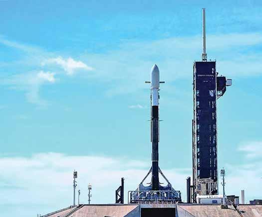
Tata Advanced Systems Ltd. (TASL), a strategic Aerospace and Defence arm of the TATA Group, has successfully launched the nation's first-ever privately developed military-grade geospatial satellite, TSAT-1A.
This sub-meter resolution satellite, built in collaboration with Satellogic, was launched aboard a SpaceX Falcon 9 rocket from the Kennedy Space Center.
TSAT-1A, manufactured at the company's Vemagal facility in Karnataka, will significantly enhance India's geospatial intelligence capabilities, providing highresolution imagery for defence and civilian applications.
Catering primarily to the armed forces and the Indian government, TASL manufacturing facility is capable of producing up to 25 LEO satellites on an annual basis.
Agnikul Cosmos, an IIT-Madras incubated startup, has launched the world’s first rocket with a singlepiece 3D printed engine.
Agnibaan SOrTeD (SubOrbital Technological Demonstrator), that was designed and manufactured in India is also the country’s first semicryogenic engine-powered rocket launch.
Agnibaan is a two-stage rocket with a carrying capacity of 300 kg that can lift off to a height of 700 km.
The kerosene/oxygen powered rocket engines are fully mobile and is able to access both low and high

inclination orbit. The objective of the test flight is to gather vital flight data and safeguard the functioning of Agnibaan, the orbital launch vehicle. While congratulating Agnikul Cosmos on the successful launch of Agnibaan-
SOrTeD, S. Somanath, ISRO Chairman said, "The launch demonstrates the prowess of indigenous design and innovation and motivates ISRO to support space startups and nongovernmental entities."
Indian SpaceTech start-up Digantara has been selected for a joint IndiaAustralia space mission to manage debris in space.
Digantara will join a cluster of SpaceTech companies under the “Space-MAITRI” (Mission for Australia-India’s Technology, Research, and Innovation) project, which recently received an AUD 8.5 Mn (INR 46 Cr) grant from the Australian Space Agency.
The Bengaluru-based start-up will integrate its proprietary optical sensor technology into the Orbital

Servicing Vehicle (OSV) developed by its partner Australian firm, Space Machines Company.
This integration will enable the monitoring of Resident Space Objects (RSOs) in Low Earth Orbit
NHPC Limited has signed a Memorandum of Understanding (MoU) with Ocean Sun, a Norwegian company operating as a technology provider to the floating solar industry. As per the MoU, NHPC and Ocean Sun will explore key areas of cooperation for the demonstration of Ocean Sun’s floating solar energy technology based on photovoltaic panels.
The panels would be mounted on hydro-elastic membranes, at relevant sites to be identified by NHPC.
The agreement is in continuation of efforts towards sustainable development and the addition of renewable energy capacity by NHPC, which is engaged not only in hydropower development but in various renewable energy projects such as solar, wind and green hydrogen projects.

(LEO), and enhance space traffic management and debris monitoring. Another Indian SpaceTech start-up, Ananth Technologies, will offer its engineering expertise and access to cleanroom facilities for the integration and testing.
LTIMindtree, a global technology consulting and digital solutions company, announced a collaboration with IBM to establish a global Generative AI Center of Excellence (CoE) in India, a co-innovation centre combining the power of the IBM Watsonx AI and data platform with the engineering skills of LTIMindtree.
Open innovation plays a key role in the LTIMindtree and IBM collaboration, driving the growth of enterprise AI to solve business challenges.
The LTIMindtree and IBM centre of excellence plans to offer a comprehensive suite of services, combining LTIMindtree’s expertise in data and Machine Learning model customization and full-stack engineering with IBM watsonx technology.


Space Intelligence Surveillance and Reconnaissance (ISR) capabilities are becoming critically essential for national development, economic wellbeing, commerce, and everyday life, besides assuming a crucial component of successful military operations.
By Lt. Col. Amandeep Singh
Space ISR is promising as a military and economic centre of gravity for our information reliant, society.
Space based assets and systems can accumulate varied
military, political, or economic information that can be valued while planning and executing range of military operations. More specifically, information can be collected, processed, exploited, and disseminated on such diverse subjects as indi-
cations and warning, targeting analysis, friendly course of action, development, adversary capability assessment, battle damage assessment (BDA), or battlespace characterization.
Evolution of Space ISR
Over the past two decades, the importance of Space ISR in national techno-economic, social-commercial and military strategic life has critically emerged.
This in itself enhances the exposure against any aggressive and antagonistic action that might seek to harm, degrade or deny space potential so meticulously built up over the decades at great cost against great odds. India’s dependence on space for vital economic purposes has been growing rapidly during the past decade or so.
Space ISR has developed as a specialized field of practice
within the broader profession of intelligence that encompasses all activities such as planning, collection, processing, analysis, exploitation and dissemination of spatial information to gain intelligence about the operational environment, visually depict the inputs and fuse the acquired inputs with other information through analysis and visualization processes for better assimilation and thus aiding in faster decision making process.
The exploitation and analysis of imagery and geospatial information to describe, assess and visually depict physical features and geographically referenced activities on the Earth acts as the fulcrum for varied military operations.
Space ISR consists of geospatial information and imagery intelligence that collectively provide innovative, versatile solutions fulfilling intelligence requirements and predicting future threat environment.
Space based intelligence collection synchronizes and integrates sensors, assets and systems for gathering data and information on an object or in an area of interest on a persistent, event or scheduled basis.
This includes early warning, targeting analysis, threat capability assessment, coverage of denied areas, situational
ISR is the collection of data and information on an object or in an Area of Interest on a continuing, event driven, or planned scheduled basis. Collection of information over comparatively continuous duration is called surveillance. Collection is planned over shorter periods, is repeated, or occurs on a relatively brief one time basis is generally referred to as reconnaissance.


awareness and battle damage assessment.
Resultantly, information superiority is expanded which is the degree of dominance in space that permits the conduct of operations at a given time and place without prohibitive interference from space based threats.
The Space ISR domain touches nearly every facet of warfare as it is essential to maintain technological superiority and strategic dominance over adversaries. Satellite technology enables Global Positioning Systems (GPS), early warning systems, and guidance for precision munitions.
Furthermore, we need tactical integrated multi-domain Space ISR at the front line for effective all domain Anti Access and Aerial Denial (A2AD) strategy.
Space ISR is a key enabling capability to achieve information

superiority over potential adversaries. Space ISR is also a key process in air operational planning in which information from satellites will play a key role to collect data as well as support conventional and unconventional activities.
Traditional military missions for land, sea and air are migrating to space with significant military applications and exploitation of Space ISR as affecting tactical battle area, operational and strategic depth.
Space ISR assists in Observe, Orient, Decide & Act (OODA) loop which enables military commander to execute the observation, orientation, decision and action phases of the process in an optimized manner.
Space ISR further augments Command, Control, Communications, Computers, Information, Intelligence, Surveillance and Reconnaissance (C4I2SR) system which allows the fusion of data from multiple sources to be able to produce a Common Operational Intelligence Picture (COIP) dealing with all aspects of information.
Space ISR capabilities allow commanders to collect information to aid them in planning and decision making. Intelligence
Space ISR has become essential to the security of a nation as it acts as first responders in the times of crises. Space ISR will see a greater transformation in the coming decade as future success will be critically dependent upon the effective utilisation of space based assets and its effective integration in creating a Common Operational Intelligence Picture in following spheres:

Space ISR incorporates strategic and operational advantages with integration and interoperability of all essential components. It facilitates coverage over the entire depth of the tactical area. Space ISR also enables real time enhancement of Space Domain Awareness with direct impact on shortening of OODA loop. With integration of C4ISR System and fusion of data from multiple sources, Space ISR provides a Common Operational Intelligence Picture (COIP).

Augmentation of Space ISR primarily encompass fusion of technology and tactics. Additionally, leveraging generative artificial intelligence with augmented computing and machine learning technologies to aid the Space base assets for evaluating the Space threats.

India’s quest for larger constellation of remote sensing satellites in the low earth orbit necessitated the concept of Modern Mass Surveillance in the strategic depth areas, Area Target Detection in the operational depth areas and Precise Target Identification in the tactical depth areas.

Specialised expertise and domain specialization in Space ISR operations demands participation of qualified and experienced military personnels during planning and designing stages. Space ISR experts should be trained throughout their careers to integrate various dimensions of space across the range of military operations and during all phases of an operation.

The diverse nature of space operations dictates that, over time, military planners should gain knowledge and understanding of the entire spectrum of space operations. The fusion between the technical expertise (satellite design) and tactical proficiency (military payload planning), is imperative to act as a bridge for better operational effectiveness.
is the produce consequential to the collection, processing, integration, corroboration, analysis, and interpretation of accessible data. Space based systems contribute to the progressive growth of intelligence through surveillance and reconnaissance actions.
Space systems offer commanders continuous observation of space, air, surface areas, places, persons, or things by visual, electronic, photographic, or other means that provide situational awareness within a given area.
Surveillance from space does not infer that a single satellite or “system” must be continuously collecting. Satellites that are able to provide a snapshot in time can be augmented by additional systems collecting in the same or even different areas of the electromagnetic spectrum.
Space superiority is the degree of supremacy in space of one force over other that permits the conduct of operations at a given time and place, without prohibitive interference from space based threats.
In the congested space environment, the theory makes available a framework in which air, sea, space, and ground based components are used to monitor or support activities in space, enabling various capabilities to maintain an awareness of space.
Space based control influence differently from other forms of military power due to its global perspective, responsiveness, and persistence. Through space capabilities, simultaneous operations affecting multiple theatres can be integrated, unlike surface forces that typically divide the battlefield into individual and geographically based theatres.
Because space related effects and targeting can be global in nature, application of space power is inherently poised to accomplish an effects based approach to space operations, based on the functional capabilities rather than geographic limitations.
The space based domain offers a unique degree of persistence with respect to military actions. The challenge for space warriors is to ensure the close knitted integration of space operations with the scheme of manoeuvre across all levels of war.
While this is no different than any other form of military capability, space operations usually occur over great distances and are conducted by units far from
The need of the hour in India is to create an integrated geospatial infrastructure that can help social, environmental, and economic information in a way that enables people to gain greater insight into complex situations.
the battlefield, so the challenge is significant.
Historically, space operations had a strategic focus, however, it leads the charge to integrate space capabilities at the operational and tactical levels of military operations.
The future success of ground forces will be critically dependent upon the effective utilization of space assets and capabilities across the spectrum of conflict. The advent of Space ISR has added a fourth dimension to modern warfare and it is imperative that the exploitation of Space ISR is done concurrently at appropriate levels, so as to achieve the desired operational capabilities in a compressed time frame.
Military applications of space and technological advances with increasing integration of space capabilities in security and war fighting doctrines have changed the nature of warfare.
The ability to utilize multiple forms of intelligence and channelize it to an automated common point of reference with minimum human interference will be critical for dominance resulting in victory on the future battlefield and enabling decision makers to arrive at the most viable course of action.
The sphere of influence of Space ISR has further grown to interplanetary travel, commercial space flights, space telescopes, surveillance of near earth objects, asteroids mining, lunar colonization, permanent occupation of space stations and not limited to new habitats for life and settlements. Space has emerged as a new medium and highlighted the urgent need to enhance awareness regarding specific space issues.

In order to modernise India's military and develop effective Space ISR, rigorous training and continuous evolvement of space assets is crucial to maintain proficiency thus, a dedicated branch is the need of the hour.

Lt Col Amandeep Singh is a serving Indian Army Officer with distinctive cross-domain expertise. He has contributed immensely in the field of Space ISR by opting for the unchartered route of Space ISR for military operations.
In an exclusive interview with Geospatial World, Arpan Sahoo, Co-Founder and COO of KaleidEO, discusses the company’s mission to deploy India's first high-resolution optical payload fleet, their partnership with ReOrbit to provide Earth Observation (EO) Infrastructure-as-a-Service, and simplifying the user experience with automated processes.
KaleidEO became the first private space tech company from India to achieve two key milestones, test edge computing in space and to design and test a high res optical, multispectral paylaod Can you please tell us about this program and the results?
At KaleidEO, we aim to build upstream capabilities within the group. KaleidEO focuses on the upstream part of generating satellite imagery, while SatSure works on interpreting that imagery into analytics and software solutions. In 2021, we started an internal project to develop the payload, which is ultimately the heart of any satellite that generates images.
Our first step was to build a proof of concept, a prototype to demonstrate the technology, reduce development risks and iteratively improve the product.
Our payload offers one-meter resolution and covers almost 65 kilometres of swath, 3x times higher than the market average of 15 to 20 kilometres. We partnered with European companies to build the prototype and assembled it in one of their laboratories , one of the tasks we have outsourced to the R&D ecosystem in that region.
Once the prototype was built, we tested it by mounting it on an aircraft to capture images of different geographies. With this, KaleidEO became the first private space tech company out of India to design, develop and test an EO, high-res, optical, multispectral payload in a maiden aerial flight.
The results were great; we achieved high-res images on the first attempt. We are now at Technology Readiness Level 6 out of 9. The next step is to launch it on a satellite & demonstrate it in space. Prior to this, KaleidEO became the first private space-tech company out of India to successfully test edge computing in space.
We have seen huge amount of EO data influx which brings a need for increased analytical capability to turn that data into actionable insights. What is KaleidEO doing to aid EO data analytics? The demand in the upstream


segment should be driven by the need in the downstream sector, which is not usually the case. If the base of the pyramid isn’t strong, the top will collapse.
We recognize the need for increased analytical capabilities to turn EO data into actionable insights. SatSure, our parent company, has been building analytics and products for end users in the focus sectors like agriculture, climate impact, forestry, insurance, infrastructure, utilities and aviation since 2017.
We, jointly, are shifting from creating bespoke solutions for each market segment to developing a standardized platform that multiple industries can use to build their own applications with remote sensing data . This platform approach allows us to multiply demand by enabling more analytics companies and end users to grow using our platform.
Our philosophy is to be an architect for the earth observation industry and enable more users to adopt satellite remote sensing
technology. KaleidEO focuses on developing analytics for strategic clients while SatSure does it for broader ecosystem, may of which are new adopters of satellite remote sensing data and insights.
KaleidEO has been positioning itself in the EO Infrastructure-as-a-Service segment. Can you throw some light KaleidEO’s offerings?
The access to data insights from satellite imagery has become easier and the cost for owning,
operating an asset and generating insights from it has reduced substantially over the last decade. What we have observed is that m any end users, who are not spacesavvy but are clear about their data requirements, are looking to onboard vendors who can help them achieve their requirements. Traditionally, they would need to coordinate with multiple stakeholders for sensors, satellites, ground stations, and data pipelines. This creates complexity.
KaleidEO, having worked in Indian space missions, and with knowledge of building analytics, takes ownership in managing these multiple stakeholders, almost working as an architect, translating data requirements into hardware specifications, mission operations and data consumption infrastructure. KaleidEO becomes a single point of contact for the entire project, and we at the backend manage everything for the client, through strong partnerships in the ecosystem.
By offering as a Space infrastructure- as- a- service, we provide a one-stop solution, reducing the end user’s burden and ensuring reliable data delivery.
KaleidEO also signed a MoU with ReOrbit to develop full-stack solutions for the EO solutions. Can you please shed some light on this partnership and projects?
Our partnership with ReOrbit exemplifies how we are showcasing our capabilities as a leading architect in the Earth Observation (EO) ecosystem through our EO Infrastructure-as-a -Service.
With our single-window portal, users can task satellites, define regions of interest, and receive analytics seamlessly. For instance, if a user needs to count cars in a specific area, they can request this data from the satellite for a specified period through our portal, and the process will be automated from there.
Once the region of interest is defined, the map is uploaded into a mission planning tool, where data aggregated from other providers is already available. The satellite's capacity is then verified and the task is scheduled accordingly.
Our system handles everything from mission planning and satellite tasking to data collection and analytics extraction. This integrated approach simplifies the user experience and offers various data delivery options, including satellite links.
For time-sensitive tasks, we have edge computing on board the satellites for immediate analytics. Users can run models and get real-time data, such as the number of cars in an area, without needing to downlink the data, providing advanced capabilities within a single satellite.
Once the data is downlinked, it is processed in a cloud-hosted


managed server, where automated pipelines generate the required analytics. This automated, integrated process enhances the user experience by ensuring quick, reliable data delivery. We plan to launch this system with ReOrbit by mid-2025.
What is the future roadmap for KaleidEO?
In the short term, we are continuing to develop disruptive payload technologies to cater to
a wider market, particularly for civilian and commercial space in emerging, price-sensitive markets in developing countries.
Currently, the market for payload solutions is geared toward strategic users, but there is potential to provide affordable, high-quality data to unlock new use cases. Although there is a lot of data available today, it lacks the right quantity and quality needed for these new applications.
There is a need to develop strategic solutions for institutional users. We are offering our payload services and consultancy, edge computing capability and building an EO IaaS. In the long term, we are looking forward to partnering with companies and consortiums to build an ecosystem which makes access to EO data and insights easy and affordable for everyone.
Interviewed

There has been an upsurge in demand for near real time data and insights. How does PierSight ensure real-time satellite data for our oceans? There are several EO satellite constellations, but they tend to be general purpose. The majority are electro-optical satellites which cannot penetrate cloud cover or image during the night.
Our satellites utilize synthetic aperture radars (SAR) which are active sensors. They can image day and night and even in poor weather conditions. As a result, a constellation of these satellites could cover every inch of the Earth at all times. But if you look at typical synthetic aperture radars (SAR), those are meant for multiple applications at a time. They cater to land mapping, ocean imaging, crop identification, et cetera.
PierSight is solving the problem of visibility in the maritime domain by building a constellation of satellites with dual sensors - Synthetic Aperture Radar (SAR) and Automated Identification System (AIS). This constellation will monitor the oceans in real-time providing situational awareness through persistent surveillance. In an exclusive interview with Vinit Bansal and Gaurav Seth, Co-founders of PierSight, they shed light on the finer details of PierSight's technologies.
We’ve taken a different approach. Our satellites are purpose-built specifically for maritime applications. We have deterministic targets in ships and other presence of human activity in the sea. This laser-sharp focus helps us optimize our satellites for wide area coverage and increased persistence.
We can capture a lot more imagery than a typical SAR satellite in a single orbit. Every 10 minutes, each satellite can image up to 2,30,000 square kilometers of ocean area.
Coupled with an optimized system for onboard processing, it makes it easier to downlink relevant information. This is the strategy through which PierSight is offering its data and analysis in real time.
Talking about data, there is an urgent need for developing sophisticated analytical tools that can cater to customer needs. With the advent of generative AI that we are seeing nowadays, do you see it as a suitable tool for geospatial and satellite data analysis?
Analysis and visualization of data is already a mature process. However, all the data is only valuable if you can derive useful insights from it. GenerativeAI has been surprisingly useful in interpreting data and making connections between disparate data.
But it certainly speeds up the querying of data and makes the life of a data analyst significantly simpler. Moreover, it could prove to be valuable for non-tech people to make sense of complex data.
However, LLMs are also known to produce erroneous information. Until the technology improves it can’t be trusted blindly.
We are witnessing an upswing in Illegal, Unreported, and Unregulated (IUU) fishing, oil spills, unsanctioned trade, and piracy amongst other oceanic problems. What are the measures that can be taken to reduce these risks? Nations and private organizations that work toward safeguarding the oceans have finite resources and struggle to reign in IUU Fishing, unsanctioned trade, detection of oil spills, or other ocean crimes.
The first step toward prevention and reduction is the ability to monitor in real time. The second step is a joint effort by nations and organizations to apprehend perpetrators. Lastly, there must be proper channels for holding them accountable.
We can speak specifically about the first step - real-time monitoring. At PierSight, we believe that situational awareness of the ocean needs to be the default. The most effective way is to have an always-on space-based monitoring system.

You could think of our constellation as giant CCTVs in the sky, equipped with microphones (listening to the AIS ping). Persistent monitoring would mean that ‘dark ships’ would no longer be dark, and ships engaged in illegal activities would find it hard to operate under the radar.
Studies show that the presence of CCTV reduces crime in a neighbourhood. There’s every reason to believe that surveillance technology could act as a deterrence for ocean crimes.
What role can space play in safeguarding our oceans and help in making our oceans more sustainable?
If you look at the United Nations Sustainable Development Goals (SDGs), the 14th Goal is about our oceans. And there are various ways how space can improve sustainability in this arena.
There was an oil spill incident earlier in the year. A barge carrying over a million gallons of oil sank off the coast of Tobago. The tugboat pulling it had turned off its AIS transponder just before it entered Tobago’s EEZ. After the incident it absconded and was finally apprehended 3 months later and thousands of kilometers away in Angola.
Were our constellation in operation, Tobago’s coastguard would have been alerted before it entered their EEZ, all because of its illegal behaviour of turning off AIS. The tugboat could have been apprehended immediately and maybe, the oil spill could have been prevented in the first place.
Data fusion from our Synthetic Aperture Radar (SAR) and Automated Identification System (AIS) would help in the detection and
identification, bringing muchneeded accountability.
Without a space-based platform, it wouldn’t be feasible to obtain real-time data for 100% of the ocean. A satellite in low earth orbit moves at eight kilometers per second and a constellation in a lower earth orbit with constant imaging capability day and night and through clouds is the most optimized way to have complete coverage over these oceans.
We finished the integration of our demo satellite recently. It will be launched soon.
Well before our first hardware has been sent to space, we’re already building solutions that solve some of the most pressing problems. In February, we won the INDUS-X for both US & Indian challenges. We devised a cuttingedge solution for detecting and tracing oil spills in near-real-time, along with its characterization, forecasting its spread, and assessing density.
More recently, we reached the finals of the NSIN-NGA grand challenge for fishing forecasting and the detection of illegal fishing.
Just as with predicting oil spill, we are also developing a solution to predict illegal fishing activity in the oceans. This challenge from NSIN-NGA underscores the need even for the US, a country with the most sophisticated coastguard.
Our complete satellite constellation will be in space by 2028. Eventually, we will build other application-specific constellations for niche SAR use cases.
Interviewed by Sachin Awana

India needs to assert its stand as a global space power carefully needing to navigate through geopolitical realities, technological advancements and strategic requirements, for that it needs to have a multi fronted approach.
By Nibedita Mohanta

The measure of great power is calculated in arms and industry, and space is so integral to it that unless there is a massive change in the current trajectory of global interaction, any future war between major powers will be won or lost in the battlefield of space.
Everett Carl Dolman Professor, Military Studies
United States Air Force University
Indian space program has hitherto been geared towards socio-economic development. However, in the era of asymmetric and hybrid battlefield, and multi-domain combat, space becomes an imperative to boost defence preparedness.
The relevance of geospatial data and space-based assets is growing rapidly with strides in technology and advanced weapons and systems, including unmanned and hypersonic platforms.
India is actively pursuing defence space capabilities in the shadow of looming growth and competition from neighbouring countries like China and Russia. With the quickly expanding space agency of China i.e. China National Space Administration, the country has very aptly demonstrated its expertise in anti-satellite weaponry and space based reconnaissance.
“India is integrating space capabilities to service its military needs. However, this has been slow due to a lack of capacity and resource infusion to create a dedicated space military architecture that can meet the needs of the Indian Armed Forces,” says Kartik Bommakanti, Senior Fellow with the Strategic Studies Programme, Observer Research Foundation.
“As our dependencies on space grows so does our vulnerability. Building a resilient space infrastructure is paramount,” emphasizes Brig G Manoj, Defence Space Agency, India
“We need to invest to develop new technologies for the defence sector, integrate space technologies into military oper-
We need to invest to develop new technologies for the defence sector, integrate space technologies into military operations and start collaborating with partners to develop military space strategy. Owning space technology is also essential as owning the technologies on earth for our national security.
ations and start collaborating with partners to develop military space strategy. Owning space technology is also essential as owning the technologies on earth for our national security,” he stresses.
Over the last decades, the Indian military has taken major steps toward the nation's defence needs. These include the launch of several communications and surveillance satellites as well as anti-satellite technologies such as EMPs.
VS Subrahmanian (VSS), Professor, Northwestern University, United States of America says, “India must develop pre-emptive cyber technology to hack enemy satellites and their communications, geolocation capabilities, and cyber-defenses to protect against other nations hacking India's satellite systems.”
“Penetration testing of Indian satellites and probing adversarial nations' satellite systems must become an urgent priority. In addition, India must continuously monitor space systems of other nations in order to understand their intentions, strengths, and weaknesses,” he adds.
Renewed strategy
The US has a Space Systems command that is responsible for ensuring that the right space systems are acquired and are interoperable with the Army, Navy and Air Force, a Space Operations Command that plans operations on top of the space systems infrastructure, and a Space Training & Readiness Command that focuses on training.
As Col. Gulshan Mehta explains that Electronic war has three basic elements: probe, attack and protect.

China conducting the ASAT test during 2007 as made India realise the importance of space security.
Like Group Captain Ajey Lele (Retd), Deputy Director General, Manohar Parrikar Institute for Defense Studies and Analyses, writes in one of his science articles, "The 1991 Gulf War is seen as a showcase for military technologies in general and space technology in particular. There was a lot of learning for the Indian armed forces too, like how best India could use space technologies to support its army, navy and air force."


Establish a Dedicated Space Force or command within the military structure, or designate a lead service for space operations depending on the national structure.
Create a JSOC that integrates personnel from all branches of the military and the space organization.
Develop Common communication protocols, data formats, and procedures for all branches to share information seamlessly. This allows for real-time data exchange and coordinated decision-making.
Conduct regular joint military exercises that incorporate space assets. These exercises will help identify and address any interoperability issues and build a strong foundation for coordinated action.
“The Indian Regional Navigation Satellite System (IRNSS), with the operational name NavIC, was developed partly because access to foreign government-controlled GNSS is not guaranteed in hostile situations, as was the case in 1999 when the US denied the Indian request for Global Positioning System (GPS) data in the Kargil region,” he added.
Space assets play a critical role in modern warfare. A strong interoperable strategy allows for coordinated use of these assets to maximize their effectiveness. The benefits of a Strong Interop-
erable Space Strategy witnessed by an enhanced military effectiveness, faster decision making, and cost efficiency.
Real-time information sharing between branches through a Joint Special Operations Command (JSOC) facilitates quicker and more informed decisions during operations. Avoiding duplication of efforts and optimizing resource allocation through joint planning leads to cost savings.
“India does not have a space strategy that is officially declared or even a strategic guidance
document on space operations whether for offensive missions, defensive missions, Space Situational Awareness (SSA) and a whole range of Intelligence, Surveillance and Reconnaissance (ISR) tasks and missions,” adds Bommakanti.
“However India does need a comprehensive review and strategy for greater joint partnership between the services and Defence Space Agency (DSA),” he further states.
The importance of GEOINT or Geospatial Intelligence for our Armed Forces remains vital, as is the need for adopting emerging GEOINT technologies, developing integrated security ecosystems, and international cooperation.
“We need to work on fusion of intelligence data. Additionally, the Defence Intelligence Agency (DIA) is the central repository for all intelligence inputs pertaining to the three Services including Imagery Intelligence (IMINT) and Electronic Intelligence (ELINT). But have we integrated the aspects of topography with the DIA?” questions Lt. Gen Prakash Katoch (Retd), a Special Forces veteran of the Indian Army
The security of geospatial data required by the Armed Forces is more complex and different than relational geospatial data; requiring data organization and structures to deny data manipulation and theft that would seriously compromise national security.
India needs to assert its stand as a global space power carefully navigating through geopolitical realities, technological advancements and strategic requirements.
For this, India needs to have a multi front approach that constitutes of satellite communication, navigation, reconnaissance and surveillance capabilities.
Future Innovations
According to Lt. Col. Amandeep Singh, India urgently needs the following capabilities:
AI based Satellite Imagery Analysis: Real-time AI and Deep Learning based solution for target identification and classification along with recognition of various spatial parameters and troop movements through satellite imagery.
Integration of C4ISR System in Space ISR: Fusion of data from multiple sources in Space ISR to produce a comprehensive intelligence picture with C4ISR (Command, Control, Communications, Computers, Intelligence, Surveillance and Reconnaissance).
IoT, IoMT & IoBT: The current social and military drifts and increased degree of progression of technologies with development in AI and IoT are revolutionary progressive actions in the military structures. Such growth would lead to a fundamental revolution

The space reforms that have been initiated by the government of India are actually a seminal moment in history.
and introduce strategies and military operations determined by AI and IoT.
Cyber Offensive: Cyberattacks are increasingly common and effective implementation could provide strategic value. Moreover, cyberattacks can threaten the stability of the battle-spaces. Therefore, militaries would have to upgrade their proficiency and skills while employing progressive structures and not shedding their conventional warfighting skills at the same time.
The space reforms that have been initiated by the government of India are actually a seminal moment in history.
“As we transition from the government led space programme to the private sector, we are going to see an expansion of both capabilities and capacities, because at the end of the day, a single organization run on government funds can only grow to a certain extent,” asserts Air Vice Marshal DV Khot (Retd.), Principal Consultant IN-SPACe, and former Director General, Defence Space Agency.
“We are going to see an expansion in capabilities, meaning advanced technologies produced through research and development, as well as in manufacturing capacity. There is a great possibility of India becoming a hub for a lot of space sector activities such as small satellite development, launch services, and particularly down-
stream applications,” he adds.
The options that India is going to get in terms of technology, applications and solutions, is simply going to be of macro scale. With all space programs lined up, the domain is definitely going to benefit hugely from the private sector.
Bommakanti says, “The private sector will have to step up investments and work alongside the military. The armed forces are starting or will need to allocate more money from their own budgets for more robust space military assets, which is tentatively underway.”
VSS states that India's private sector in the space domain has two major advantages over foreign nations: a focus on frugal innovation, and a focus on technology that addresses specific threats to India.
“As an example, small and cheap drones have had an outsized impact on the Ukraine war. In the same way, we would expect swarms of small, cheap, weaponized satellites to potentially nullify any advantages that India's space adversaries might have,” adds VSS.
India's private sector has a substantial yet unrealised role to play in advancing India's military space programme and country's space military capabilities.

Nibedita Mohanta
Sr. Assistant Editor
Geospatial World Nibedita@geospatialmedia.net
In an interview with Geospatial World, Lieutenant General Vinod G. Khandare, PVSM, AVSM, SM, Former Officer, the Indian Army; and Principal Adviser, Ministry of Defence, speaks about the need for GeoIntelligence strategy in Indo-Pacific region.

Geospatial is used in everyone’s daily life. Take an example of the nodal ministry, or the Science and Technology Ministry, but practically every ministry and every department is capable and they should use geospatial technology.
Where geospatial information is needed the most today?
The most important requirement today is to make students understand technology in our schools or colleges.
Whatever is taught is possibly the basic or the fundamental issue about technology. But conferences, seminars, or closed door ideating sessions, they have the capability to explain to people the difference between theoretical technology and technology applications.
The geospatial applications is used in everyone’s daily life. Take an example of the nodal ministry, or the Science and Technology Ministry, but practically every ministry and every department is capable and they should use geospatial technology.
What is the need for geo intelligence strategy in Indo-Pacific region?
The term Indo-Pacific got coined because of the geopolitical order
of the world, as President Obama used to say, “Asia is the pivot now”. So the entire emphasis has shifted towards the Indo-Pacific region.
There are many reasons for it, whether it is the revisionist China coming ahead and threatening Taiwan or the Southeast Asian nations or the ASEAN nations questioning the authority of international conventions.
There is a challenge to the world order, and this challenge happens to be coming out of the Indo-Pacific region. In addition, this region has more than 50% of the population, nearly 90% of the world trade going through this, possibly the future of the world to a large extent, rests on Indo-Pacific.
And to be able to do well or to survive in this area, you need information. And geospatial technology or geospatial intelligence is one of the primary means today, space being the high ground.

Now you can see everything, if there is any suspicious activity going on or if there is suspicious presence, or suspicious movement in that area. All that comes beautifully from the geospatial technology.
What is the role of geospatial technology in defense ground?
In defense services, whichever be the service, Air Force, Navy or Army, information is the most important thing. Information gets collected using various sensors, whether it is a human sensor or it is an imagery sensor, or it is something which picks up your radar activity.
All that is information, but that has to be analyzed. And then assessments come out, and that is called the intelligence.
Geospatial technology gives you an overview where all kinds of intelligence gets fixed. Say if you pick up from a sensor or radar, but what does your satellite imagery give you? It gets corroborated.
If you pick up, from human intelligence that there has been a movement of military vehicles, what does the geospatial intelligence tell you? Does it corroborate or it doesn't corroborate? So to that extent, I think there is a strong presence of geospatial technology to corroborate what other sensors are telling you.
Interviewed by Nibedita Mohanta
The intersection of geospatial and digital twin is key for exploring benefits and challenges in the context of multi-domain regional security.
By Major General Dr. Dilawar Singh
In the ever-evolving landscape of global security, the Indo-Pacific region is at the forefront of technological innovation and strategic competition. The convergence of geospatial intelligence and digital twins is transforming the way nations approach regional security, enabling more effective decision-making, enhanced situational awareness, and improved operational efficiency.
Geospatial intelligence (GEOINT) has become a critical component of modern military operations, providing valuable insights into the physical environment and enabling informed decision-making.
The Indo-Pacific region is home to some of the world's most complex and dynamic environments, from the densely
populated cities of Southeast Asia to the remote and rugged terrain of the Himalayas. GEOINT plays a vital role in understanding these environments, enabling military forces to anticipate and respond to emerging threats.

According to Dr. John Smith, Director of the US Air Force's GEOINT Program, "Geospatial intelligence is the foundation of modern military operations. It
provides the situational awareness and context necessary for effective decision-making, allowing military forces to operate more efficiently and effectively in complex environments."
Digital twins are virtual replicas of real-world objects or systems that mimic their behaviour and performance in a simulated environment.
These digital models are created by integrating data from various sources, such as sensors, cameras, and other devices, to provide a comprehensive view of the system or object being modelled.
Digital twins can be used to simulate various scenarios, predict outcomes, and optimize performance, making them an invaluable tool for military operations.
The US Navy has been at the forefront of leveraging digital twins for warfighting, developing a comprehensive digital twin for its naval vessels. This digital twin simulates the performance of ships in various scenarios, such as combat operations, disaster response, and routine maintenance.
According to Rear Admiral Michael Brown, Commander of the US Navy's Digital Twin Program, "Digital twins have revolutionized the way we train and operate our naval vessels. They provide real-time data and insights that enable our personnel to make informed decisions and optimize operations."
Applications in MultiDomain Regional Security
Digital twins have numerous applications in multi-domain
Several real-world applications of digital twins in multi-domain regional security demonstrate their potential to transform military operations. For example

The US Air Force has developed a digital twin for its F-16 fighter jets, integrating data from various sensors and systems to optimize performance and maintenance. This has resulted in significant improvements in the aircraft's reliability and readiness.

The US Navy has developed a comprehensive digital twin for its naval vessels, simulating the performance of ships in various scenarios and providing real-time data for training and testing. This has enabled naval personnel to train more effectively and prepare for a wide range of contingencies.

The US Army has developed a spatial digital twin for its military operations, integrating data from various sources to provide a comprehensive view of the battlefield. This has enabled military commanders to make informed decisions and optimize operations.
regional security, from optimizing supply chain management to enhancing training and simulation.
In the Indo-Pacific, digital twins can be used to simulate various scenarios, such as naval operations in the South China Sea or air operations in the skies above the Korean Peninsula.
According to Dr. Jane Doe, Director of the US Air Force's Digital Twin Program, "Digital twins can be used to simulate
complex scenarios, allowing military personnel to train and practice in a realistic and immersive environment. This enhances their readiness and responsiveness, enabling them to operate more effectively in the face of emerging threats."
While digital twins offer numerous benefits, there are also challenges and considerations involved in their adoption. One of
the primary concerns is data integration and interoperability, as digital twins rely on vast amounts of data from various sources.
According to Dr. John Smith, "Digital twins require robust cybersecurity measures to protect sensitive data and prevent unauthorized access."
Another challenge is the cost and complexity associated with developing and implementing digital twins.
According to Rear Admiral Michael Brown, "Developing and implementing digital twins requires significant investment in hardware, software, and personnel. However, the benefits they offer make them an invaluable tool for military operations."
As digital twins continue to evolve
The Indo-Pacific region is home to some of the world's most complex and dynamic environments, from the densely populated cities of Southeast Asia to the remote and rugged terrain of the Himalayas. GEOINT plays a vital role in understanding these environments.
and mature, we can expect to see even more innovative applications in multi-domain regional security. One exciting trend is the integration of artificial intelligence and machine learning into digital twins, enabling them to learn and adapt over time.
By leveraging these technologies, digital twins can become more accurate, responsive, and capable of predicting and preventing potential issues.
According to Dr. Jane Doe, "The integration of AI and ML into

digital twins will revolutionize the way we approach warfighting. It will enable us to anticipate and respond to emerging threats more effectively, and to optimize operations in real-time."
In conclusion, the convergence of geospatial intelligence and digital twins is transforming the way nations approach multi-domain regional security in the Indo-Pacific.
These technologies offer numerous benefits, from enhanced situational awareness to improved operational efficiency. While there are challenges and considerations involved in their adoption, the benefits they offer make them an invaluable tool for military operations.
As Dr. John Smith aptly states, "Geospatial intelligence and digital twins are the future of warfighting. They will enable military forces to operate more effectively and efficiently, and to stay ahead of the curve in an increasingly complex and dynamic environment."

Major General Dr. Dilawar Singh serves as a Senior Advisor at the Indian Centre for Interdisciplinary Studies in Science and Technologies and Senior Vice President of the Global Economist Forum ECOSOC United Nations.
In an exclusive interview, Dr Nithiyanandam, Head of the Takshashila Institution's Geospatial Research Program discusses India's unique approach to military space development and increasing importance of geospatial in defense.
Considering the need for interoperability between the army, navy, air force, and space organisations, how can India develop an effective space strategy?
There is a need to maximize the use of space-based resources, focusing particularly on downstream applications, including optimising requirements through defence challenges.
Ideally, sharing raw data from a central source could be beneficial, particularly when multiple services have diverse applications that rely on specific electromagnetic spectrums.
For instance, one scientist might utilize the spectrum to analyse changes in vegetation on land, while another scientist could apply it to study water bodies. It depends on different scientist’s interpretation of satellite images for different purposes.
As the threat from land, water, and air increases, the monitoring and mapping of sea and land do not belong to just one service.
What role can India's private sector play in advancing the military space program and bolstering the nation's space capabilities?
The focus of the Indian Private Sector currently is on expanding our remote sensing capabilities regarding launches, constellations, and building larger satellites.
There is less emphasis on scientific research and exploring new frontiers as there is no incentive or business opportunity currently to invest time and money in these areas.
There is a need to innovate and push to new arenas of space-based applications in dual-use technology applications in the civilian domain.
We're seeing rapid advancements in AI and ML. In what way can emerging tech like this be used in national security?
Technology is growing at a rapid pace India and should be Used to improve our efforts and increase our preparedness, surveillance, and counteraction against possible threats. For effective utilisation, we need to clearly understand the technology and apply it at the right time for the correct application.
This means that not all applications require AI and ML for information extraction instead simple digital image processing and classical numerical modelling techniques may provide the necessary output. This prevents the demand for AI and ML in every software solution.
How can geospatial technologies effectively integrate into existing military and intelligence

frameworks to understand national security risks?
There is a need to sensitize and build capacity with different agencies and primarily stakeholders who are components of the national security framework including state police and border security forces.
This will bring awareness on new applications of geospatial technologies for the workforce in the national security domain. The tool can also help in reducing the workforce and money we are spending at present.
Secondly, geospatial technology has different vital components, not just maps. The opportunity for defence personnel to learn a broad spectrum of geospatial technology is limited, as teaching in traditional setups still focuses on image interpretation of maps and cartography.
Thirdly, Geospatial technology is a matter of “thinking spatially,” and not just the data and computing facility. There should be a careful appreciation and utilisation of the opensource information available in the domain.
Interviewed by Jeffy
Jacob
In an exclusive conversation with Major General SA Kulatunge, RWP, RSP, VSV, USP, PSC, Sri Lanka Army, wherein, he discusses how geospatial with the amalgamation of emerging technologies such as AI and ML can aid in defense of the island-nation.
How can geospatial aid in Sri Lanka's defense?
Geospatial can help in many ways. Apart from the traditional threats, Sri Lanka is facing many non-traditional threats. Some of them are drug and human trafficking, which are turning into a major problem.
So to be able to have real-time information through geospatial is going to assist us and the decision-makers in engaging and also finding solutions to prevent and protect Sri Lanka against these non-traditional threats.
Sri Lanka is also working on a DC3IC platform for greater interoperability between the different armed forces. Can you please talk about it more?


The DC3IC platform is at a very infant stage right now where we have come up with a proposal after witnessing the need to have a platform through which all agencies can be linked together for greater interoperability. Basically, to have everything related to defense needs under one umbrella.
That's what the DC3IC platform is trying to do, where the decision makers without just having data at the hands will have a collaborated and corroborated dataset which is already analyzed.
Then the real-time data that is required for the edition makers will be provided to them. So basically that's what we are looking at and then we'll be able to get the support of international partners and take this forward.
With emerging technologies such as AI and machine learning, do you think they can aid in increasing defense capabilities?
Of course they can. We’ve seen how it's done, especially in India and many other countries where information is received in layers and with the help of AI, it is filtered down to real-time information intelligence, which supports decision-making.
Machine learning algorithms can also help us in predicting and simulating defense scenarios to prepare in advance against adverse situations.
So yes, machine learning and artificial intelligence is going to and will always be very essential for decision-making.
As these modern datasets come up, new cyber threats are also evolving. How do you think we can tackle these challenges?

The more digitalized we become, the more we start depending upon AI and other technologies. This creates chances of hacking and creating nuisance amongst critical infrastructure.
Thus, an urgency is born to make data and security go hand in hand. We need to be aware of the possible cyber threats as it was highlighted, amply highlighted during the sessions.
It is a key factor where we need to keep in mind that we can depend on certain technologies but at the same time the technology can be hampered with. This is going to be essential.
Integrating new datasets and geospatial data with traditional defence systems has been one of your focus. Can you please talk more about it?
To explain this, I'll take the example of Sri Lanka where we are heavily dependent on humanitarian and traditional defense systems as of now.
We are presently using various digital platforms to map our defense processes end to end, as well as, keep track of any emerging threats. We are using AI and similar datasets to map it. However, to translate these datasets into actionable insights, we still need the conventional military to go in and act.
Interviewed by Sachin Awana
Bhoomicam is developing solutions for farmers to help them take the right decisions about their field through the advent of new age technologies. In an interview Dr. Siddhartha Khare, Founder, Bhoomicam Pvt. Ltd., & Assistant Professor at IIT Roorkee, discusses how geospatial technology can enable precision and sustainable farming in India.
Precision farming can augment sustainability issues that we're facing. What technologies is Bhoomicam uses for precision farming?
Bhoomicam is using a plethora of technologies to aid precision farming such as airborne drone spray which uses only a fraction of water very efficiently. If you can save certain level of water in one season of your crop cycle, it helps
a lot in the larger picture.
It is important for the farmers to get healthy farming information from the local panchayats, as they're also providing a lot of relevant knowledge in terms of precision farming techniques, as well as, natural farming.
For example, if I can know in advance about the weather
conditions in the coming days, I would water my field accordingly and adequately. If this level information can reach to the farmers, we can move towards a holistic sustainable agriculture landscape.
To enable this, we have to make farmers tech savvy. To aid this, we are using technologies such as remote sensing to extract information like different vegetation and diseases to help farmers know their crop health. And through this process we are also linking the farmers with monetary support.
We are generating credit scores for farmers as an incentive strategy to enable them take up better measures in farm management. This credit score is given on the basis of farm management, product usage efficiency, and good yield towards the end of the season.
How can the new-age technologies such as AI and Satellite help improve farming practices in India? Through remote sensing one can get information about land without any physical contact to the ground. This is enabled by the satellites that we have in space. The advantage of the remote sensing lies with the have different spectral characteristics and the information that you get about the subject.
So with the help of satellite and multispectral information, we can actually extract very important information of the crop health at different stages.
We can extract this information of different vegetation indices as well as the soil health. All these information can be combined together for raising awareness in farmers’ community.
What we are trying to do here is to develop a solution to assist farmers in evaluating their credit worthiness and provide farmers with hassle free loans so that they can cultivate crops in a more secure environment.
With the combination of GIS and GPS technology, we can let the banking sector know about the possibilities of farm financing. After that any personnel from their revenue department can go to the field, assess and monitor the field and file all the information required. This way they can strategise about the loans and the bond amount.
What we are trying to do here is to geo-enable each farm by utilizing the boundaries in addition to their information on seasonal crops. Then, integrating AI with satellite data to carry out long-term crop monitoring, conducting in-depth field analysis, and scanning dry vegetation crisis comes as our part.
You talked about how there is a need to make farmers tech savvy and a major hindrance towards it is that the geospatial datasets are intrinsically difficult to understand and analyze. How does Bhoomicam ensure that its data is comprehensible and coherent for farmers? Talking about data analysis and understanding the data, it is imperative to provide that information in a very simple language. We at Bhoomicam have addressed this issue by creating a very simple platform as by engaging and understanding the mindset of the farmers.
We have developed India’s first Agri-Drone as a Service (ADAS) android platform where it is catering all types of farmers

(small, medium, and large land holding). This platform enables and connect all farmers on a single platform and provide them opportunity to join either as a customer if they are small farmers or join as a drone service provider in that region if they can afford to buy Agri-drone under govt. subsidized schemes.
The best part about this ADAS platform is to attract farmers to use modern drone technology without worrying about its cost, maintenance, flying operations and management. When they book our services, we talk to them and understand their purpose.
We have curated our platform based on these feedbacks. This way, we are brining them on our platform and then introducing them to complex geospatial information in a simpler ways.
We try to understand if we can convert it into simple information as our target audience isn’t tech savvy. We cannot expect them to use high-level complex technologies in the field from the get go. So first of all, we have to make them at ease. Now when you talk about satellite remote sensing and high complex geospatial data, it is very important to ease the processing part. It is a very crucial part as you're dealing
with the high resolution images of satellite data, time lapse images/ videos and a lot of GIS data.
We have dedicated team that works towards the process and analyze this data. But when we talk about the presentation of this information to the farmer, we are just giving a very simple report so they can see and immediately interpret their current crop health.
The first thing that Bhoomicam is currently targeting is the Central and Northern region. We are starting with an application which is available on android devices. So we are going to start these services in Uttar Pradesh, Haryana and Uttrakhand while targeting different type of farmers. We are going to work with the farmers and provide them our services by using our Drone spray service applications.
After this, we'll be having an important database about the farmers and the type of crops they are working upon in their field and the challenges they are facing. We'll be having all these data and which will be slowly penetrate with the web tool and mobile based platform which is like the invite based application for monitoring through satellite.
We'll also provide them with this information as we are in touch on a regular basis with our service. This way, they can also start taking the advisories and better their farm practices. The web tool is going to help us at national level as we will connect with different insurance companies and banks to distribute proper loans to farmers.
Interviewed by Sachin Awana

The 14th edition of the Indo-Pacific Geointelligence Forum commenced in New Delhi, with a strong focus on “Multi-Domain Regional Security” showcasing the region’s strategic importance and the growing role of geospatial technology.
The two day event highlighted the combined power of geospatial intelligence, space based assets and the latest innovations to address engaging threats in one of the world’s most dynamic and strategic regions. The Indo-Pacific is one of the fastest growing region being a critical hub for international trade and commerce.

The two day event kick-started with Lt. Gen AKS Chandele, President of Defence, Internal
Security, and Public Safety at Geospatial World setting the tone for the conference by underscoring the significance of the Indo Pacific region. He remarked saying, "Geospatial technology plays a critical role in defence and security, enabling effective crisis management and ensuring safety during emergencies.”
General VK Singh, PVSM, AVSM, YSM stated, "Indo-Pacific is a region that contributes to our GDP and the trade that passes. Hence there’s a need for technologies to counter what you see. We need greater coordination and cooperation to grasp a clear picture and the need to utilize all the utilities and GeoInt applications, from Artificial Intelligence to data."
Echoing the statements, Lt. Gen Rakesh Kapoor, Deputy

Chief of the Army Staff (Information Systems and Coordination), noted, "Militaries in this region require geospatial tech to gain a competitive advantage over their adversaries. The Indo-Pacific is a theatre of rivalries."

Vice Admiral Tarun Sobti, Deputy Chief of the Indian Naval Staff, addressed the vastness of the Indo-Pacific region, stretching from the Gulf of Oman in the west to the U.S. Pacific coast in the east.
He emphasized the region's maritime importance, with over 50% of the world's trade and 90% of India's trade passing through these waters. However, he also expressed concern over the increase in piracy, illegal fishing and smuggling.
"The existence of non-traditional threats requires the ability to detect and act upon them," Vice Admiral Sobti stated. He cited the role of modern technology, particularly space-based assets, unmanned systems, data and imagery in enhancing maritime domain awareness.

Vice Admiral LS Pathania, Chief Hydrographer for the Government of India, reiterated the critical role of open, inclusive and rule based
order in managing the Indo-Pacific region. He highlighted how high-resolution satellite imagery, accurate positioning systems, and advanced depth imaging equipment transforms our understanding of sea and land. "Geospatial technologies provide a common platform for collaboration, enabling countries to share data and build trust," he said.

Lt. Gen RS Raman, Director General of Military Intelligence for the Indian Army, elaborated on the evolving nature of geospatial technology. He referred to geospatial as an ecosystem rather than just technology and emphasized its role in both civilian and military applications. "Geospatial is an ecosystem, not a technology, which is evolving in perpetuity. In the internal security scenario, details on demographic and social development indices have a direct correlation with civilian applications," he noted.

"The combination of advanced AI with strategic insights enables agile response and boosts defence capabilities," said Saurabh Rai, CEO of Arahas.

Sanjay Kumar, CEO of Geospatial World, highlighted the Indian government's commitment to investing $8-10 billion in geospatial development over the next five years. He emphasized the importance of collaboration for capacity and technology development.
He reiterated the need for a Defence Geospatial Enterprise saying, “India is home to half the

world's democratic population, demonstrating remarkable resilience but requires proactive leadership to ensure preparedness. What we need to create now is a dedicated defence geospatial enterprise."
The Indo-Pacific region accounts for more than 65% of global GDP and is home to some of the world's most populous nations. With rising geopolitical tensions, the need to safeguard countries, commerce, and critical assets has never been more urgent.
Moderated by Vice Admiral LS Pathania, the session on how “Geospatial Technology can boost Indo-Pacific Security” explored how geospatial technology can enhance security in the region.

Dr. Prateek Sharma, Vice Chancellor of Delhi Technical University, discussed India's vision for an open, inclusive, and rulesbased order in the Indo-Pacific. He laid out the role of geospatial strategically saying, “The interconnectedness of the indo-Pacific region and the interdependence of the two oceans is a product of growing forces of globalisation, trade and changing equations
between different actors.”

Maj Gen (Dr.) Ashok Kumar, VSM, from the Centre for Joint Warfare Studies (CENJOWS), emphasized the strategic significance of the Indo-Pacific. He pointed out that the region hosts seven of the world's largest militaries and most of the world's nuclear powers, barring Israel and the UK. "The Indo-Pacific is the world's fastest-growing, most diverse, and data-rich region," he stated.

The event wrapped up with the Lt General Vinod Khandare, PVSM, AVSM, SM, Principal Advisor, Ministry of Defence highlighting India’s growing prowess in the geospatial domain.
He highlighted the need for India to reduce dependence on foreign technology and technology transfers the need to collaborate with international experts without relying on. He emphasized on collaboration, saying, “The geospatial domain isn’t just about defence; it has the potential to accelerate India’s economic growth. Becoming “space literate” and developing policies that promote geospatial applications are essential steps in this direction.”
The 'Power for All' programme was the Government of India’s commitment to improving the quality of life of its citizens through higher electricity consumption. A collaborative effort between the Government of India and state governments, the system is used in this case in Uttar Pradesh and Bihar.
Its primary aim was to ensure uninterrupted power supply to households, industries, commercial establishments, and other consumers while also providing sufficient power to support agricultural needs.

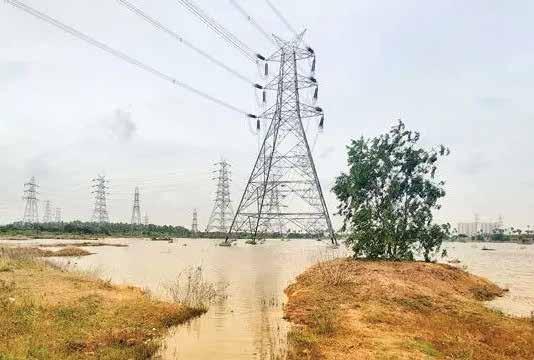
Identifying power demand at 15-minute time intervals.
Identifying the cause of power usage deviations.
The digitalisation of power prediction-related calculations.
Rectifying financial losses due to miscalculation of power requirements.
Accurately predicting power consumption to avoid energy wastage.
A narrowed frequency for energy transport from 49.9 Hz to 50.05 Hz dictated the necessity of accurate power predictions.
Weather conditions were a crucial factor influencing power consumption and power usage prediction became accurate with its incorporation in the prediction model.
Mercados EMI created an AI-based demand forecasting solution called jouleOS, utilizing Environmental Data Services from The Weather Company, an IBM Business.
Artificial intelligence-powered prediction of power usage was employed.
The prediction model first analysed demand by using the state's historical demand data with historical weather pattern data obtained from The Weather Company's History on Demand data package.
Utilized the Weather Company's Enhanced Forecast data and the IBM Environmental Intelligence Suite to achieve the desired data resolution.
This allowed for more accurate forecasting, down to 15-minute intervals and within a geographic radius of 500 x 500 meters, a significant improvement over the previous three-hour weather data available from open-source databases.
The Indian National Centre for Ocean Information Services (INCOIS), operating under the Ministry of Earth Sciences (MoES), has launched a mobile application named 'SAMUDRA' (Smart Access to Marine Users for Ocean Data Resources and Advisories).
“SAMUDRA” is envisioned to give an easy access for users to the ocean information and advisory services. This app
serves as a valuable resource for seafarers and the fishing community, providing extensive information on various ocean-related services to aid in their activities.
SAMUDRA aims to promote sustainable ocean activities and contribute to the Blue Economy, supporting marine safety and profitable fishing operations. The app is available in eight coastal languages and can be downloaded from the INCOIS website.


Systematically gathering realtime data and conducting risk assessments.
Establishing hazard detection, monitoring, and early warning services.
Communicating threat information and early warnings.
Information on a day-to-day basis on the sea and coastlines is made available on the SAMUDRA App. This integrated system disseminates alerts to fishermen and seafarers in case of vulnerable situations.
INCOIS has been offering fishing zone and Ocean State Forecast (OSF) services through SMS to around 7 lakh fishermen across coastal states
The app provides Potential Fishing Zone (PFZ) advisories, guiding them to fish aggregation locations, and improving their catch rates and livelihoods.
The app features interactive maps, charts, and animations for a better understanding of the phenomena.

The Mumbai Coastal Road project by the Municipal Corporation of Greater Mumbai (MCGM) Coastal Road Project is a project aimed to create an 8-lane freeway spanning 29.2 kilometres along the western coastline, connecting Marine Lines in the south to Kandivali in the north.
The road when completed can accommodate 130,000 daily vehicles, significantly reducing travel times between South Mumbai and the Western Suburbs from two hours to 40 minutes, enhancing metropolitan mobility and accessibility.
Coordination of design drawings for various utilities like sea walls, promenades, viaducts, and underpasses.
Heavy traffic congestion in the area leading to extreme air pollution.
Unstable soil conditions in certain project site areas require specialized engineering solutions.
Besides the coastal road, multiple elements such as the sea wall, promenade, bridge viaduct, pedestrian underpass, vehicle underpass, box culvert, car parking, interchange, and recreational spaces needed design attention, increasing project complexity where accurate clash visualization was crucial.
The SAI-SYSTRA Group utilized 3D data and Bentley applications to create 3D models for each project component, enabling effective clash detection and identification of interferences through 3D drive-through simulations.
The utilization of a 3D model enabled efficient quantity calculation, providing an accurate assessment of the required materials in a fraction of the time and with significantly reduced effort.
The dynamic 3D model significantly reduced design modification time by approximately 50 percent. Compared to traditional drafting methods, it resulted in a remarkable 90 percent reduction in drafting efforts.
The implementation of clash detection and a deeper project comprehension empowered the engineering team to deliver a precise and optimized design, resulting in elevated project output quality and substantial cost savings during construction and also enabled enhanced collaboration among diverse project teams facilitated streamlined project coordination.
An exclusive interview with Vivek Saxena, Scientist-F and Team Lead for Enterprise GIS Software, Defence Geoinformatics Research Establishment (DGRE)-DRDO.
What are the current research priorities of the DGRE?
DGRE right now are developing tailor made solutions for defence forces by utilising FOSS4G stack as well as advance AI techniques. This approach ensures there is no vendor lock-in, offering flexibility and cost-effectiveness for clients.
Open standards and free and open source software are prioritized to create safe and secure solutions for the defence forces.
However, diligent study has also been carried out on transactional spectrum of COTS geospatial offerings of OEMs.
We also conduct thorough

evaluations of geospatial offerings to stay informed about the latest technologies and incorporate them into our research efforts.
How can private sector participation make Indian Defence Space more innovative and cutting edge? The private sector works with agility in this hyper competitive market of geospatial. Further, they have various solutions to address complex problems of defence space.
By collaborating with defence forces, the private sector can strengthen and empower nations to counter existing and emerging adversaries.


What potential does convergence of GeoInt and AI hold for safeguarding against emerging security threats in this region?
In the near future, big data and AI will become increasingly integrated with current geospatial solutions. This convergence will provide valuable insights into various aspects of emerging threats, whether maritime, geopolitical, or environmental.
For example, AI-driven intelligence combined with exploiting high-resolution satellite imagery can enable precise demarcation of land boundaries, enhancing border security.


The National Database for Emergency Management is a geospatial portal, developed by ISRO in partnership with disaster management organizations, strategically crafted to furnish space-based information and services concerning natural calamities throughout India.
Situated in Hyderabad, NDEM serves as an essential resource for aiding decision-makers and authorities responsible for disaster management in both the state and national domains.
NDEM, currently at version 4.1, serves as a platform for disaster preparedness, hazard assessment, damage evaluation, and emergency response, providing spatial and textual data for decision-makers.
Integrating diverse datasets into a cohesive multi-scale geospatial database.
Maintaining real-time updates for a dynamic nationwide database, especially for hazard-specific data.
Designing a user-friendly Geo-Portal akin to NDEM with multiple modules.
Developing systems for generating geospatial statistics, charts, and reports from the extensive dataset.
Ensuring platform scalability to handle increased data loads and evolving functionalities to meet disaster management requirements.
The dashboard integrates high-resolution space-based imagery to offer value-added products.
Components of the portal include a disaster dashboard, a disaster event card, product updates, disaster-related news with social media inputs, an online feedback system, multiscale geospatial datasets, decision-making and utility tools, among others.
Seamlessly integrates space-based data, forecasts, and disaster alerts, providing a structured nationwide database, decision support tools, and resource management modules.
Automates relief and rescue efforts, offers multi-language support, and includes a mobile-friendly version, NDEM Lite, enhancing accessibility and usability during disaster management.

Inaccurate land surveying can have significant consequences like boundary disputes, errors in construction projects, and environmental impacts. Hence, while developing a national project like road construction, accurate and precise surveying is crucial in addition to adhering with the stringent rules.
Skytek Drones, a Hyderabad-based drone services company, was commissioned to survey a designated road development site. Leveraging advanced drone mapping technology, their objective was to collect essential data, encompassing digital surface models (DSM), digital terrain models (DTM), and volumetric analysis.
This comprehensive data collection aimed to not only ensure adherence to stringent regulatory requirements but also streamline project planning for optimal efficiency.
To gather extensive survey data within a limited timeframe while ensuring compliance with government regulations.
To accurately capture elevation data and analyze stockpiles using advanced mapping techniques
Utilized a Mavic 3E RTK drone with advanced photogrammetry to capture high-resolution aerial imagery of the survey area.
Leveraged PIX4Dmatic software to process aerial images and generate accurate ortho-mosaics and point clouds.
Employed PIX4Dsurvey to create detailed digital terrain models and perform volumetric analysis of stockpiles for project planning and compliance.
Integrated drone mapping technology and PIX4D software to deliver precise results quickly and efficiently, ensuring compliance with regulatory requirements.
Achieved significant time savings in surveying for road development projects compared to traditional methods, enabling faster project timelines.
Generated highly accurate and detailed survey data compliant with regulatory requirements.
Showcased expertise in drone mapping and photogrammetry to potential clients, leading to increased business opportunities and growth.
Demonstrated the effectiveness of drone mapping as an innovative surveying solution.


Technology Used GIS, Drones/ UAVs, Digital Twin, BIM, CAD
The Chenab Rail Bridge, a marvel of engineering, graces the Reasi district of Jammu and Kashmir, India. As the world's highest rail-arch bridge, it soars 359 meters above the Chenab River, boasting a 467-meter arch span and a total length of 1,315 meters.
Being a key component of the Jammu-Udhampur-Srinagar-Baramulla Rail Line (JUSBRL) project, the bridge was developed with the aim to reduce travel times, fostering economic growth and improved connectivity within the region.
Ensuring slope stabilization and addressing potential seismic activities in the region.
Coping with persistent high winds and extreme weather conditions.
Designing the bridge to withstand demanding conditions, including 260-kilometers-per-hour wind forces, blast impact loads, and temperatures plummeting below -20 degrees Celsius.
Executing construction using the world's longest-span cable crane and cable cars, which presented unique logistical hurdles.
MicroStation utilized for assessing Survey of India maps, minimizing interoperability issues during on-site operations.
STAAD and RM Bridge employed for comprehensive structural analysis and design, including viaduct design.
ContextCapture facilitated construction planning, monitoring, and safety inspections.
OpenRail Designer enabled the transition to a curved double-lane bridge alignment.
Tekla Structures organized plate materials in 3D models, optimizing logistics and expediting approvals. It also generated reports for material quantities, assembly dimensions, and center of gravity calculations. It also facilitated fabrication within on-site temporary workshops.
Achieved a 225-day reduction in the surveying phase.
Slashed construction inspection time by an impressive 80 percent.
Realized substantial cost savings of INR 1.2 crores across the project.


