Portfolio | A journey of “urban” exploration





Ziyi Guo
Wuhan, Hubei, China
ziyiguo6@163.com | ziyiguo@hust.edu.cn
EDUCATION
Huazhong University of Science and Technology
Bachelor of Architecture, Minor in Urban Design. 2018-2023 (expected)
GPA: 3.91/4.0 (Major GPA: 4.00/4.0) Freshman Scholarship (03. 2019), Merit Scholarship (03. 2019 & 03. 2020), Technology Innovation Scholarship (10. 2021 & 03. 2022)
University of Oxford
Summer School, Future Cities and Public Policy. 2021.7-2021.9
NC State University
Certificate, Developing Cultural Competence Program. 2021.9-2021.10
EXPERIENCE
Gerber Architekten
Architectural Intern. 2022.7-2022.10
engage in Shenzhen Longgang District Yunhe International School Renovation Project National Artificial Intelligence Industrial Park (Guangzhou) Design Competition Shanghai University (Jiading) Design and Renovation Project South University of Science and Technology Renovation Project
Tongji-MIT City Science Lab @Shanghai
Research Assistant, 2021.10-present
NICE 2035 Project: completed literature review, categorization, and case study
SoCity Project: cooperated with SoCity team in launching a DAO aiming to promote urban prosocial behaviors with decentralized incentive policy
Community Stake Project: explore possibilities for urban residents’ joint decision making in urban planning Hostess and Organizer of 2022 MIT City Science Summit “ SoCity Community DAO: A New Prosocial Urban Development Process” workshop. 2022.10
Huazhong University of Science and Technology
Research Assistant, Xu Studio, 2019.10-2021.10
Team Leader, National Training Program of Innovation and Entrepreneurship for Undergraduate, 2020.1-2021.5
EXTRACURRICULAR ACTIVITIES
Sunners Social Development and Innova�on Center
Director of the Research Center. 2020.9-2022.9
Organized various workshops and theme days for the "Sunners - Rural Charity" summer camp
Collaborated with One Take Architect in designing the architecture workshop on the theme of joint architecture exploration and creation with children in rural areas of China
Planed and scheduled community courses with local and the Beijing Planning Institute in various Wuhan communities incl. Self-awareness, Cognitive Mapping of Community Environment, and Community Service
Endless Me - Aesthe�c Exhibi�on for Rural Children (Wuhan)
Co-Curator, 2021.3
Responsible for scene setup of the architecture workshop’s interactive installation “Hi Ladder”

AWARDS
Young Architect Compe��on(YAC) - Leisure Harbor
Finalist, Team Leader of 2.
“New Zhengdong Cup” Historical Building Research Compe��on
2nd Price, Team Leader of 3.
01 Farmland Above the Metro
Coupled Food and Transportation System Design
talks about #Food Sufficiency, #Public Transportation, #TOD, #Metro Network
02 We, The Village and The City
Self-organized Way to Renovate Urban Village in China.
talks about #DAO, #Pro-social Behaviors, #Incentive Policies, #Self-organized Cities
03 Vertical Community
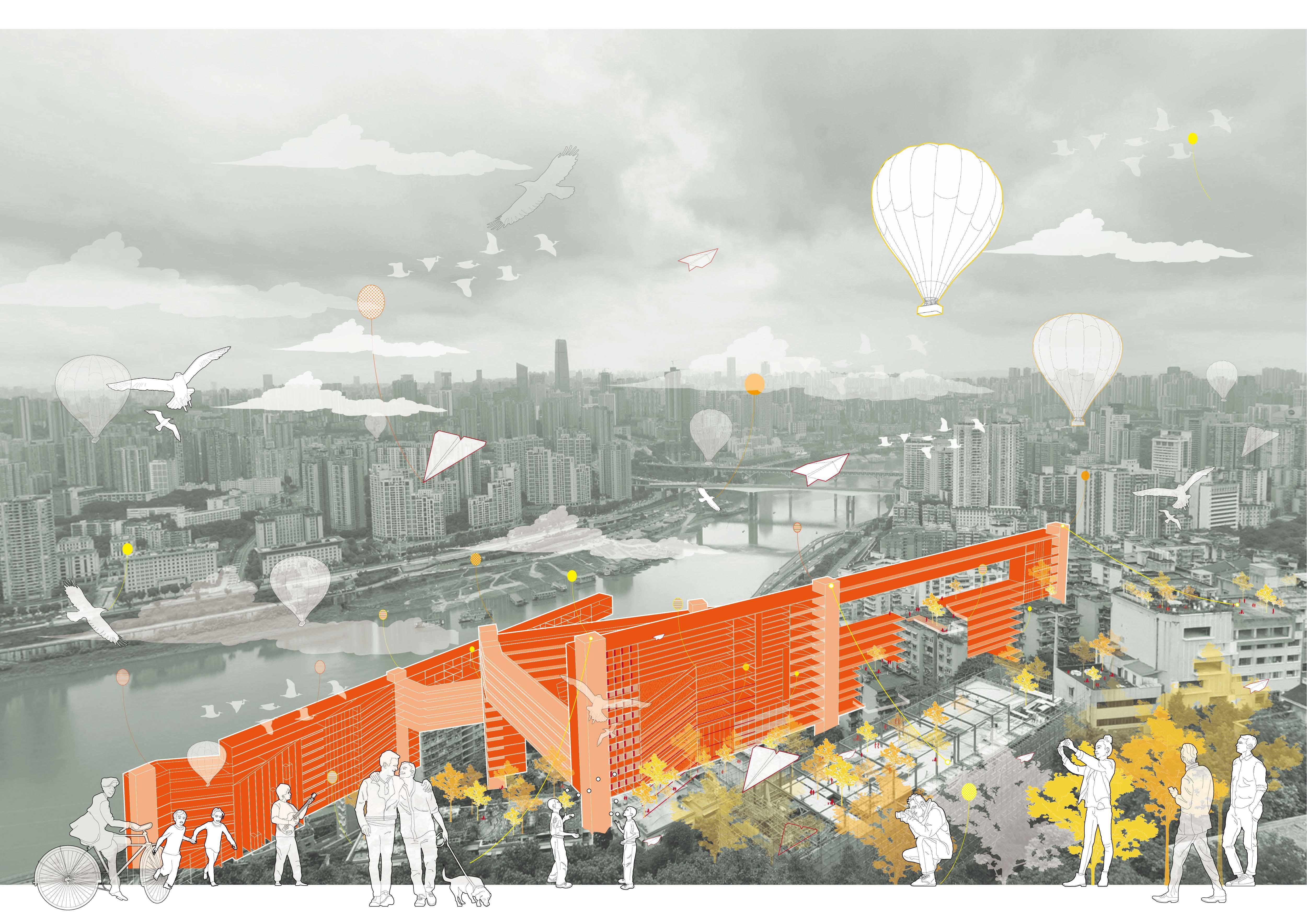
Vertical Urbanism responding to Mountainous City
talks about #Weblebrity City, #Moutainous City, #Tourist Attractions
04 Post-industrial Paradise
Adaptive Reuse of City’s Industrial Heritage
talks about #Industrial Heritage, #Steel Plant, #Deconstruction of Meaning
| Ziyi
Guo
| Contents
01 Farmland Above the Metro
Coupled Food and Transportation System Design
Location: Shanghai, China
Time: 2022.6-2022.10
Individual Work
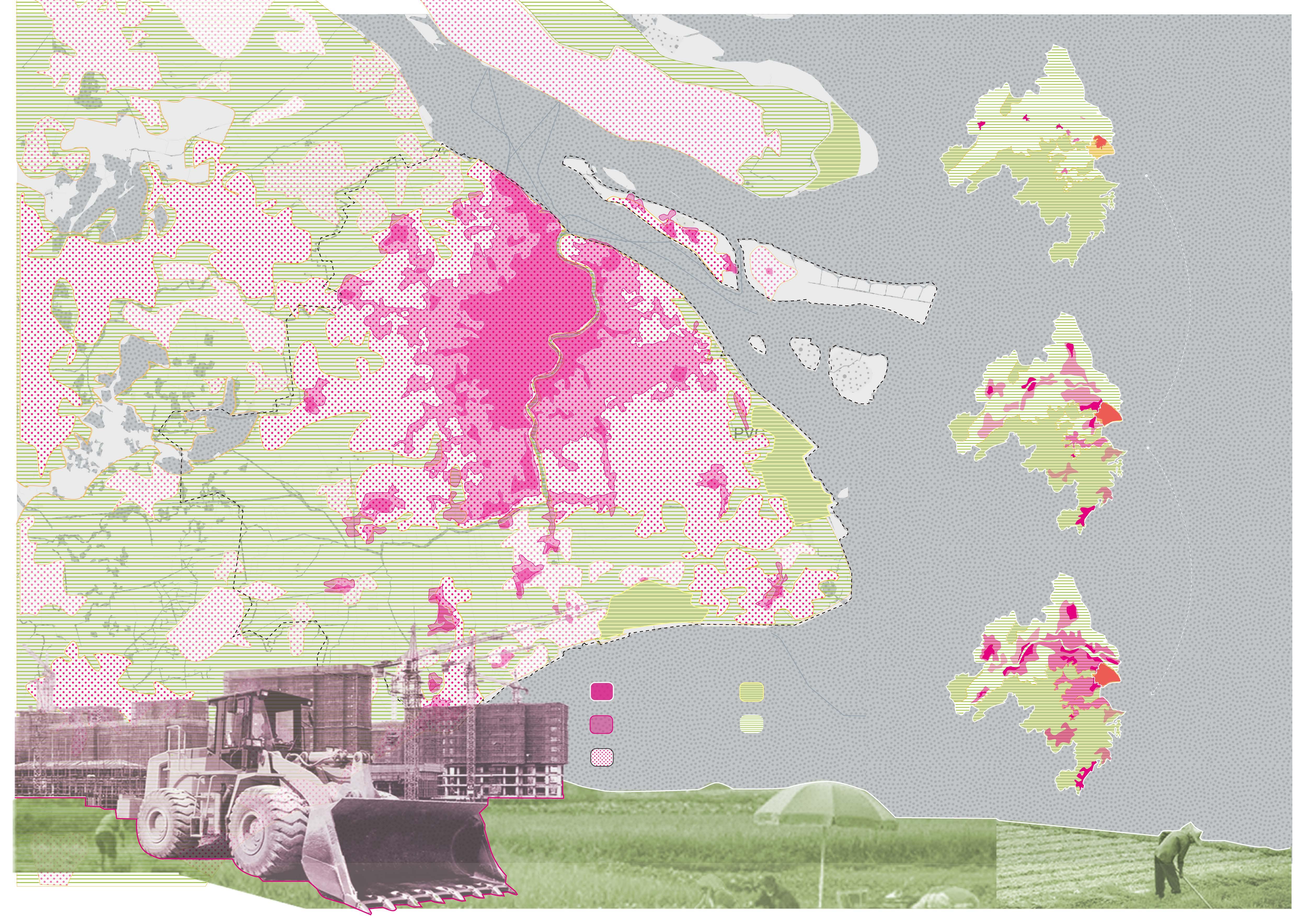
As arable land continuesly shrink due to urban area's expansion, we are facing the problem of food shortage, food insecurity and higher food prices. This project propose a new way of establishing future food systems within the city to ensure food sufficiency. In the proposal, embed food system in city's metro network to cultivate, transport and deliver food to people's door.
Arable Landloss in Shanghai
As city continuesly expand, arable land are exploited and occupied for city’s development. The rapid urbanization could lead to economic growth, though it could also cause losing of arable land, food shortage and insecurity.
Arable Landloss in the Middle-Lower Yangtze Plains
Arable
Arable
total arable land: 837.17 (10k ha) total arable land: 746.08 (10k ha) total arable land: 639.17 (10k ha) 2000 2000 built-up area 2010 built-up area 2020 built-up area cropland forest 2010 2020
landloss: 91.09
by: 10.9%
(10k ha) Decreased
landloss:
by:
106.91 (10k ha) Decreased
14.3%
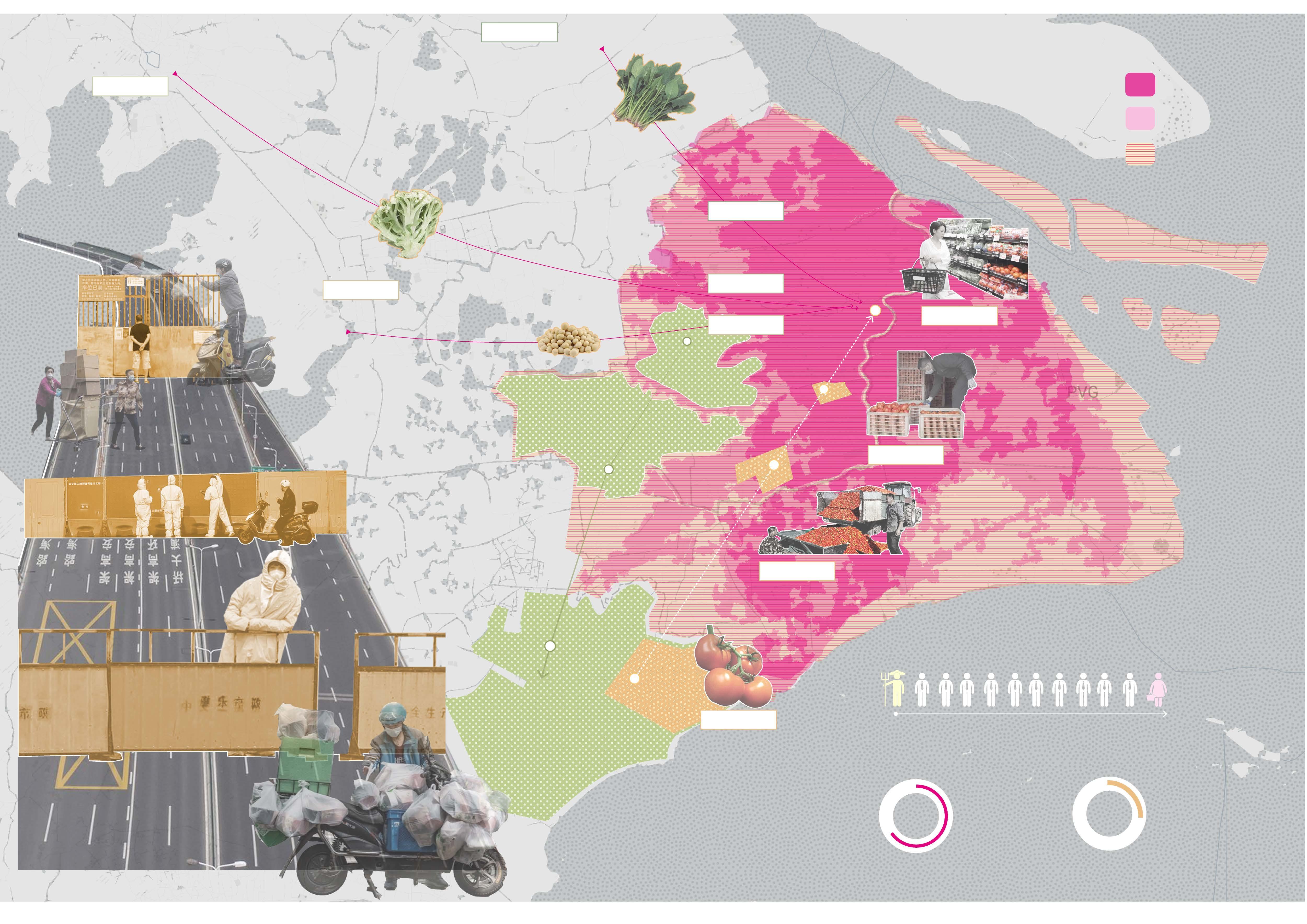
Longer Transport Distance Result in Fragile Food Supply Chain
1.6yuan / 500g
Cropland-Anhui Province
2000 Local crop base 2010 Local crop
base
500g 1.8yuan / 500g 1.1yuan / 500g
Longer Transport Distance Result in Higher Food Prices
0.8yuan / 500g
farmer intermediators
There are more that 10 intermediator links between farmers and consumers in a typical food circulation system
intermediate cost farmers’ revenue 70% 25%
overall cost selling price consumer
3.0
2.5yuan
/
yuan / 500g 12.0yuan / 500g
5.7
5.9
2000 City boundary 2010 City boundary 2020 City boundary
1.7yuan / 500g
yuan / 500g
yuan / 500g
Shanghai’s
major agricultural land migrant outwards as urban area continuously expand itself.
2020 Local
Retail Cropland
In 2022 Shanghai Lockdown, roads are blocked by government and all transportation are paused, food logistic stopped. People strive to access to food while most of them struggle their lives in hunger because of lacking of food.
crop base
Agent Wholesalers 1490km
560km +$ +$ +$ +$ +$ +$ +$ +$ +$ +$
Croplandthe Nei Monggol Autonomous Region Cropland-Gansu Province
1778km
Arable Landloss Lead to Longer Transport Distance
Opportunities
Metro Network could be utilized to Establish Future Food System
02
Covering
03
04

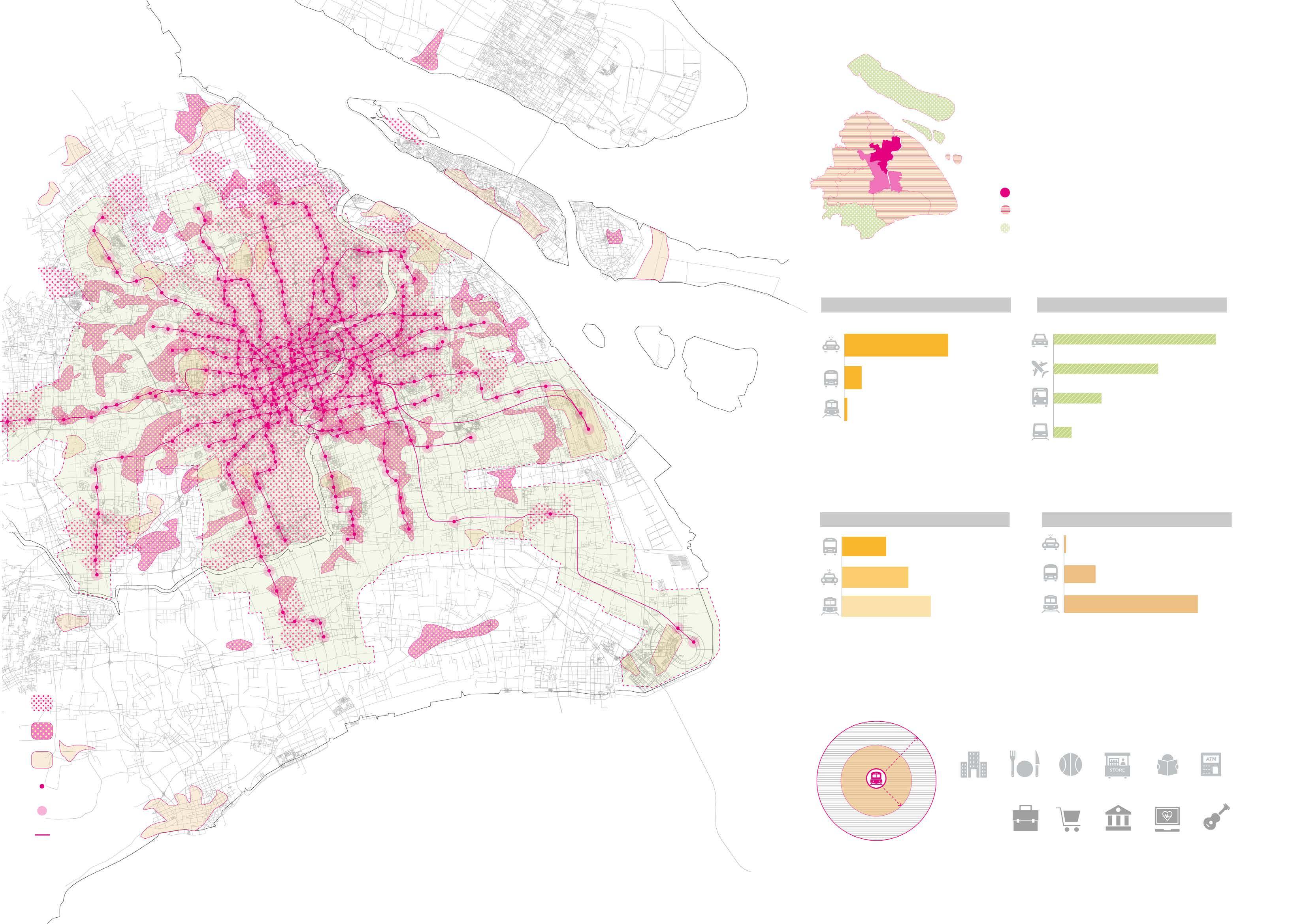
173 111 51 19 14 2 82 40km/h 40km/h 1.2 34 143 80km/h 800m 400m Town Residential Shanghai’s Metro System and Its Surrounding Lands Use Other built Metro station Metro station service scale Metro line
most of central districts Connect all suburban districts Covering 14 of overall 16 municipal district 20 lines 508 stations 831km operating range (the longest in the world)
covered districts Metro connected districts Metro not covered districts
High Coverage Chongming District Jinshan District Energy Consumption Carbon Emission Subway has the lowest energy consumption Subway has the lowest carbon emission g (standard coral burning)/per person*km carbon emission per passenger kilometer
Metro
01
Environment Friendly Subway has the highest speed Subway
goods/people
could carry the most
Vehicle Carrying Coefficient
subway
core 15min community life circle central circle residential business governance healthcare amusement mall restaurant sports market&store school amenity
Time-saving and Efficient Velocity
City developes as taking
station as the circle
TOD development
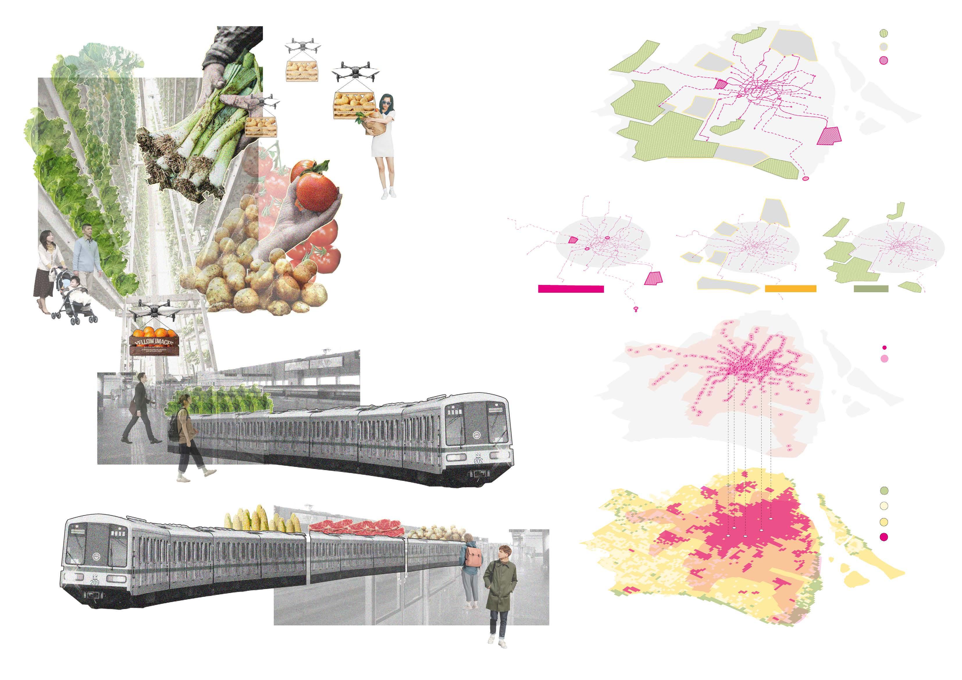
Embed Future Food System on City’s Metro Network
Subway Line Network
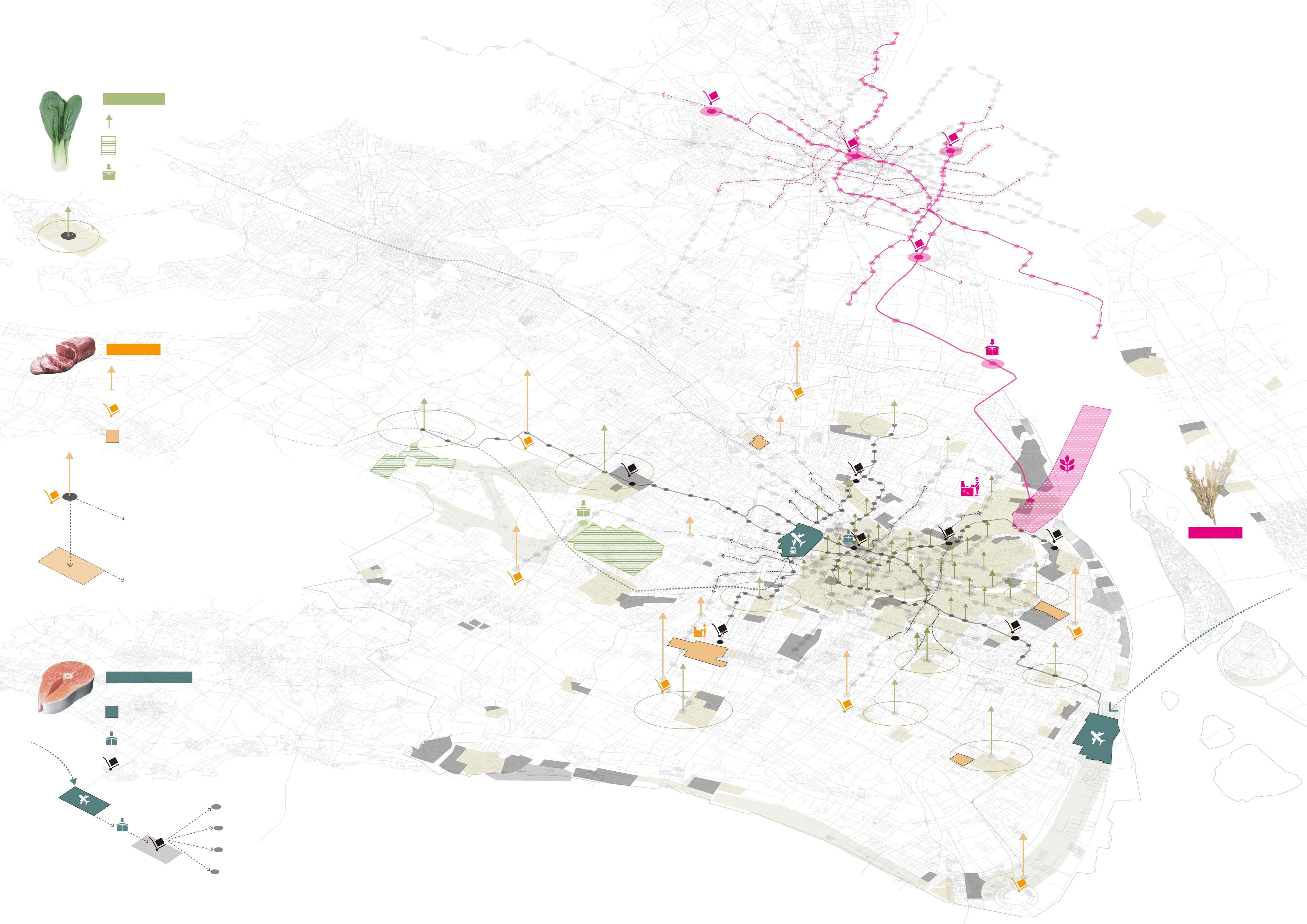
Subway lines form an intense network which connects city’s transportation hubs, major industrial zones and croplands. All of these could be used to form a food system based on subway lines.
Hongqiao Airport Shanghai Railway Station
Shanghai South Railway Station
Transportation Hubs
Food Center
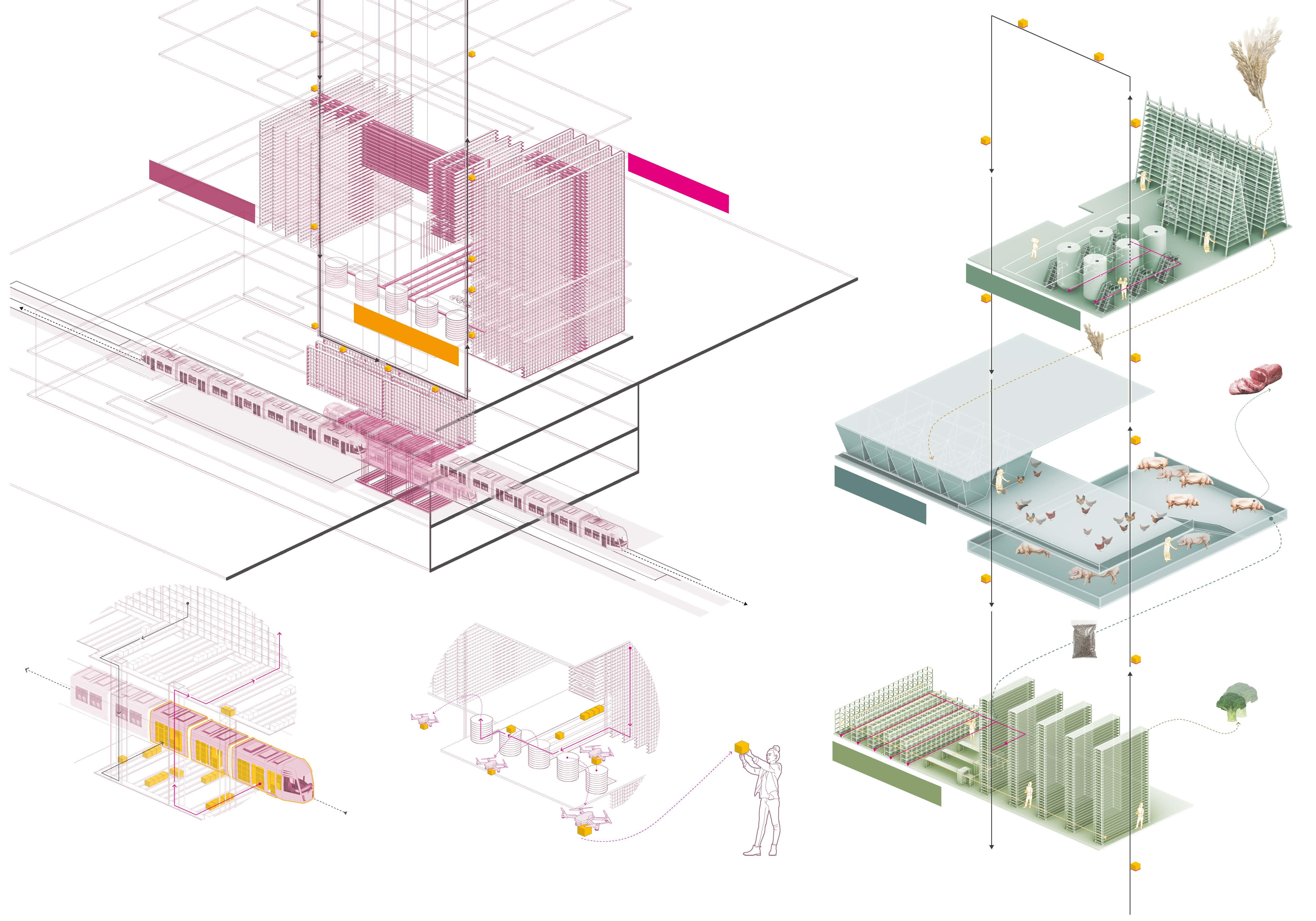
We could use the subway station as a food center, which could cultivate, store, process food.It could serve a community food provider at a r=3000m scale.
Songjiang Pudong International Airport
Fengxian Baoshan
Minhang
Fengxian
Yangshan Harbor
Croplands Industrial Zones
Subway Station 120m life circle
Subway Station
Every individual have daily food needs so population density could reflect the city’s demand for food density.
Food Circulation Network
Subway train could carry food from one station to another, which makes it a perfect transportation tool for food to communicate between food centers
1-50 people/km²
51-100 people/km²
101-2500 people/km²
>2500 people/km²
Population Density
CentralArea PudongNewDistrict NanhuiDistrict MinhangDistrict QingpuDistrict JiadingDistrict BaoshanDistrict
People could choose to shop here directly or have the drones deliver the food they ordered on the app to their doors.
City Cropland Industrial Zone Transportation Hub
Food Systems Design
Vegatables
Cultivate & Harvest—metro station
Cultivate & Harvest—cropland
Gathering & Distribution
Railway
3km
People have more requirements for vegatables’ fresh level, so vegatables are mostly planted above each metro stations to feed r=3km life circle residents
Meat
Poultry production & butcher Meat dealing & selling
Meat gathering & distribution
Meat/egg/milk product process
Shanghai-Suzhou-Huzhou
Metro stations in suburban areas can be used to produce and burcher poultry and process raw meat roughly.
Pack and transport raw meat to metro stations in central areas
Pack and transport meat production to metro stations in central areas
Imported Food
Imported transportation hubs
Dealing & Packing
Gathering & Distributing
Refrigeratories are close to industrial land so extra electric power could be used
Railway
Food Center
Rice Gathering
Food Center
Food Center
Food Center
Rice Gathering
Rice Gathering
Food Center
Food Center
Food Center
Rice Gathering
Food Center
Food Center
Rice Package
Rice Rough Machining Rice Finishing
Rice seeds storage
Rice cultivate
Rice
Imported Food arrive at airport
After concentrated processing and packing, imported food are distributed to 7 refrigeratory and then be transported to each metro station/food center on demand
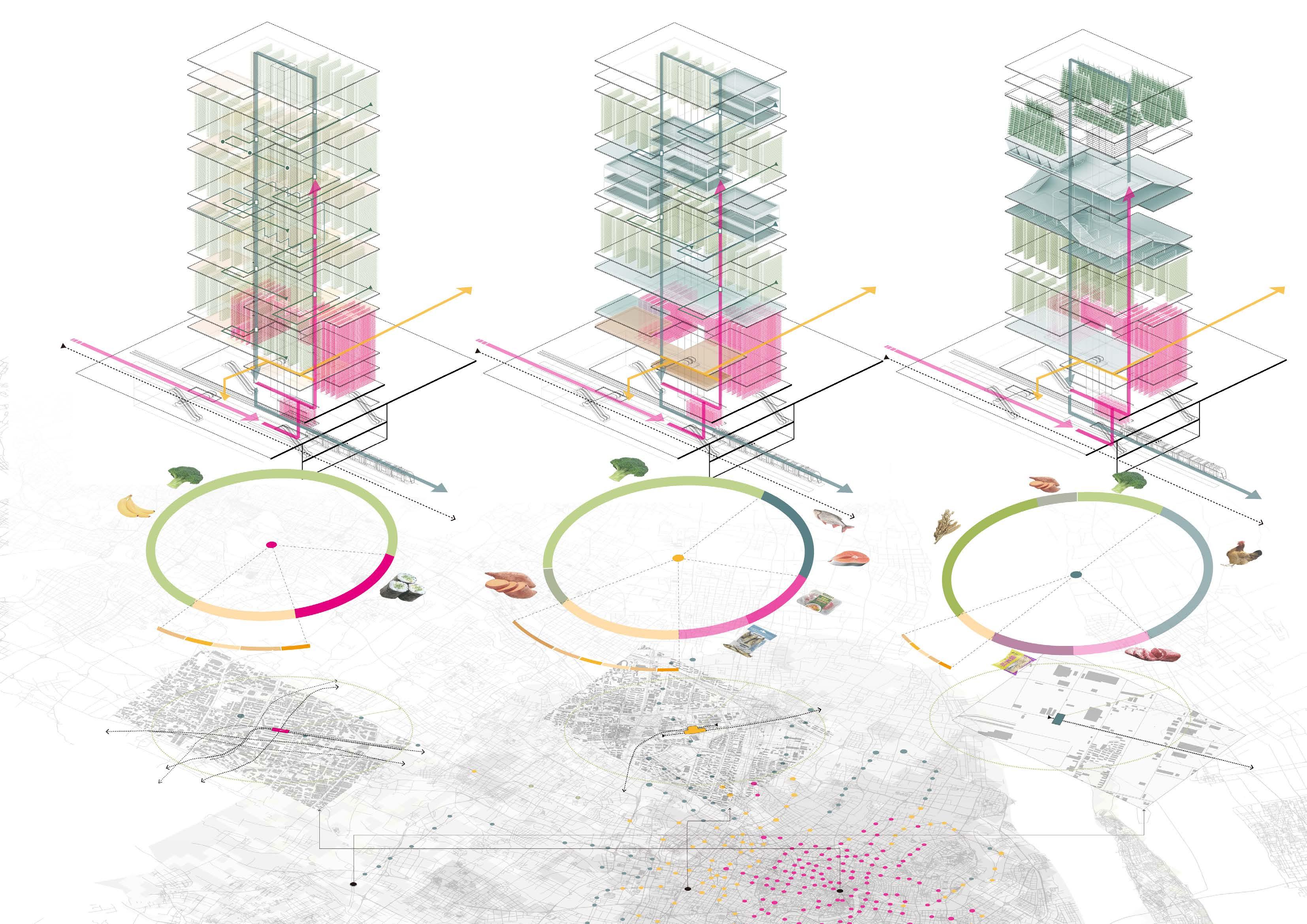
70% 10% 20% 10% 30% 10% 10% 30% 5% 40% 20% 15% 10% 5% 10% 5% Temporary Storage Vegetables & FruitsCul�va�on Input Food Storage Output Food Storage Home Delivery Supermarket Cultivate Process Storage Temporary Storage Vegetables & Fruits Cul�va�on Aquaculture Refrigerated storage Input Food Storage Output Food Storage Premade Food Process Home Delivery Supermarket Densely populated residen�al areas Type B- Xinzhuang Sta�on Type A- Changshu Road Sta�on Type C- Fengxian New Town Sta�on Medium populated Industrial Zones Sparsely populated Industrial Zones Cultivation A Processing A Storage Storage Storage Cultivation A Cultivation A Aquaculture Poultry Process B Process D Process E Process C Cultivation B Cultivation B Cultivation C Temporary Storage Poultry Farming Poultry Process Input Food Storage Output Food Storage Grain Crops Cul�va�on Home Delivery Supermarket Vegetables & Fruits Cul�va�on Food Centers Classification & Design Food Centers Design Food Centers Urban Context Food Centers Production function distribution Food Centers Classification Accoring to city’s population density distribution, metro stations are classified into three categories
Food Centers
Detailed Spatial Design
Output Food Storage
Output grain crops
Input Food Storage
Home Delivery
Food Logis�c System of Food Center
Food Storage
Poultry Farming
Grain Crops
Cultivation
Output feeds for poultry animals
Output meat, eggs and milk
Output fer�lizer for vegetables cul�va�on
Load output food
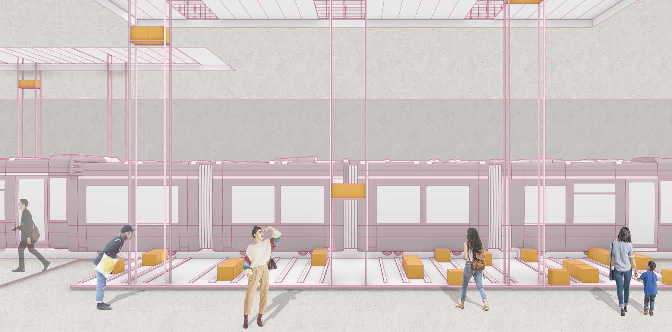
Loading & Unloading
A�ach extra several metro coaches
behind original coaches to carry food
Output vegetables
Vegetable Cultivation Home Delivery
boxes. Coaches are connected with a set
of logis�c system to transfer food from
Unload input food
and towards food center.
Use unmanned aerial vehicles
as the delivery tool for the center-to-home delivery.
Food Produc�on System of Food Center
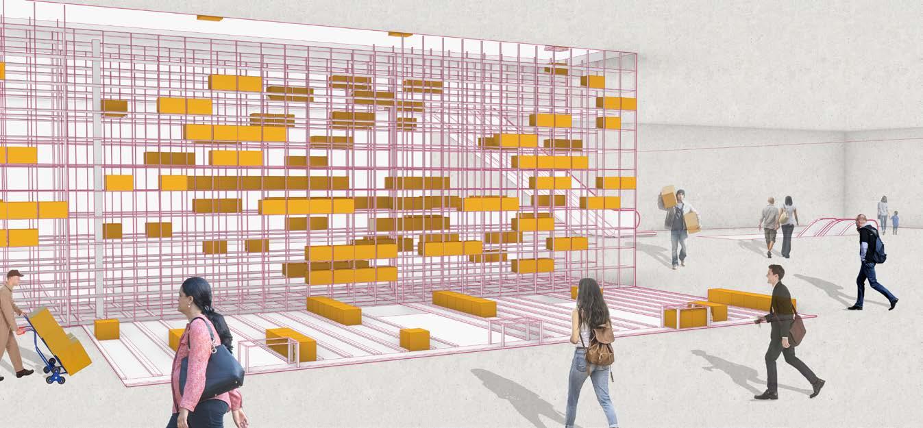
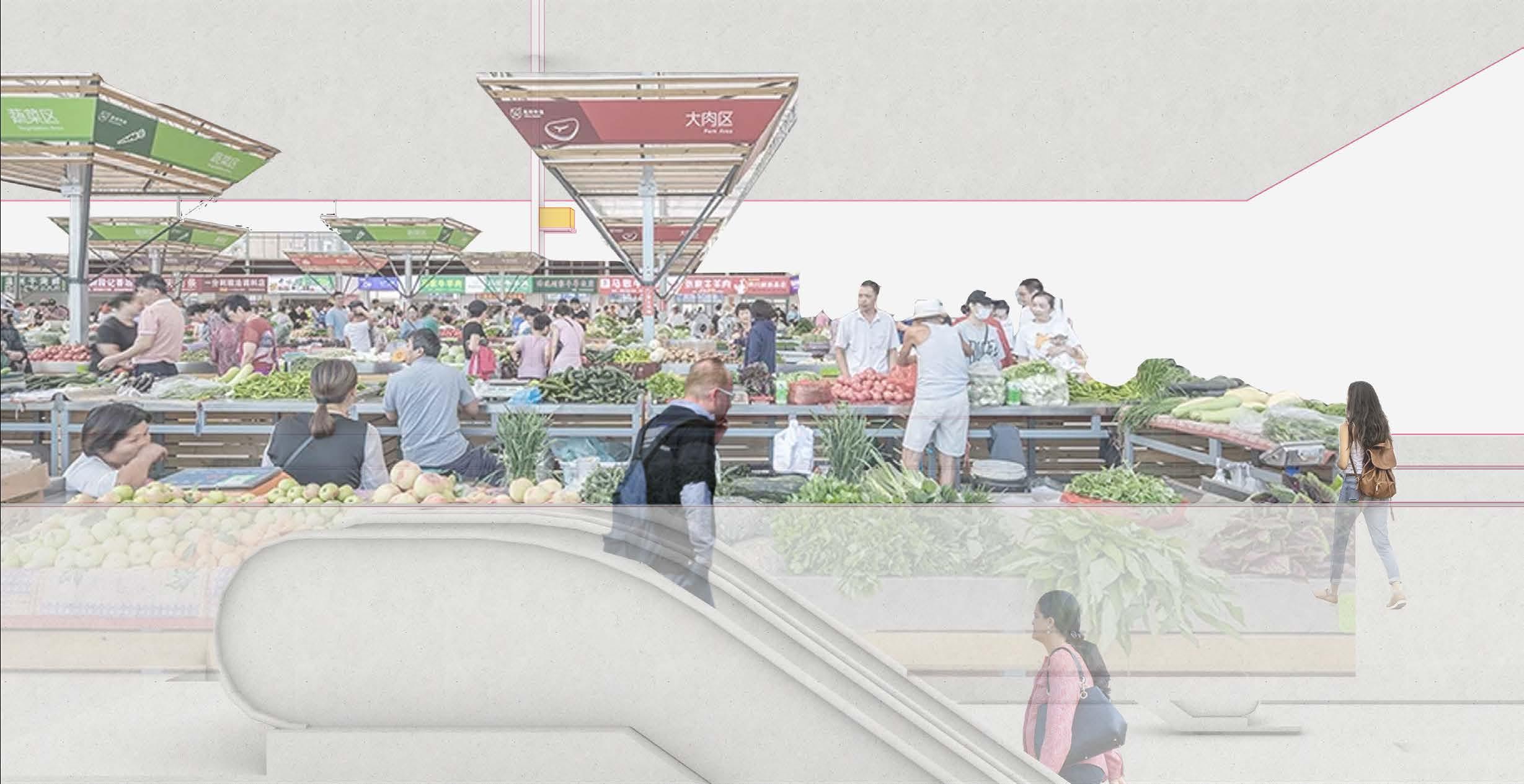
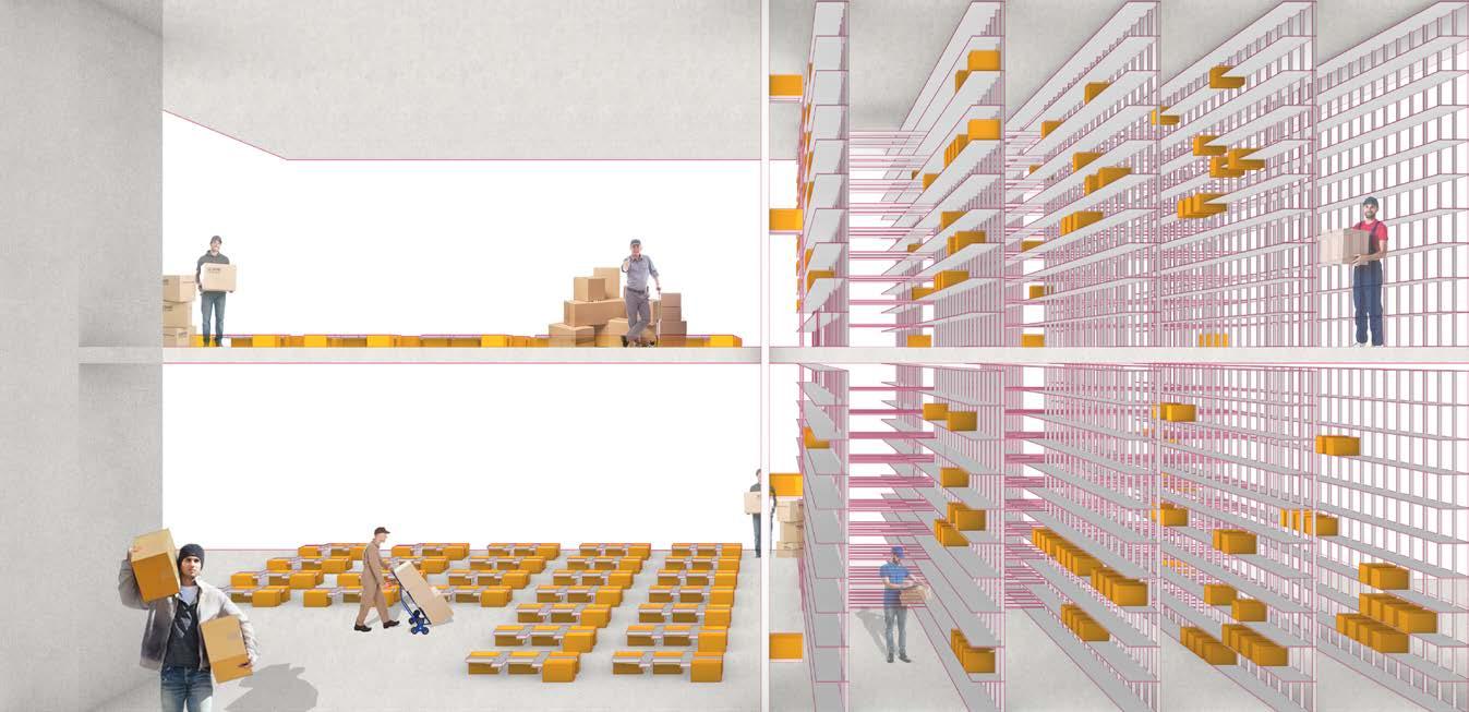
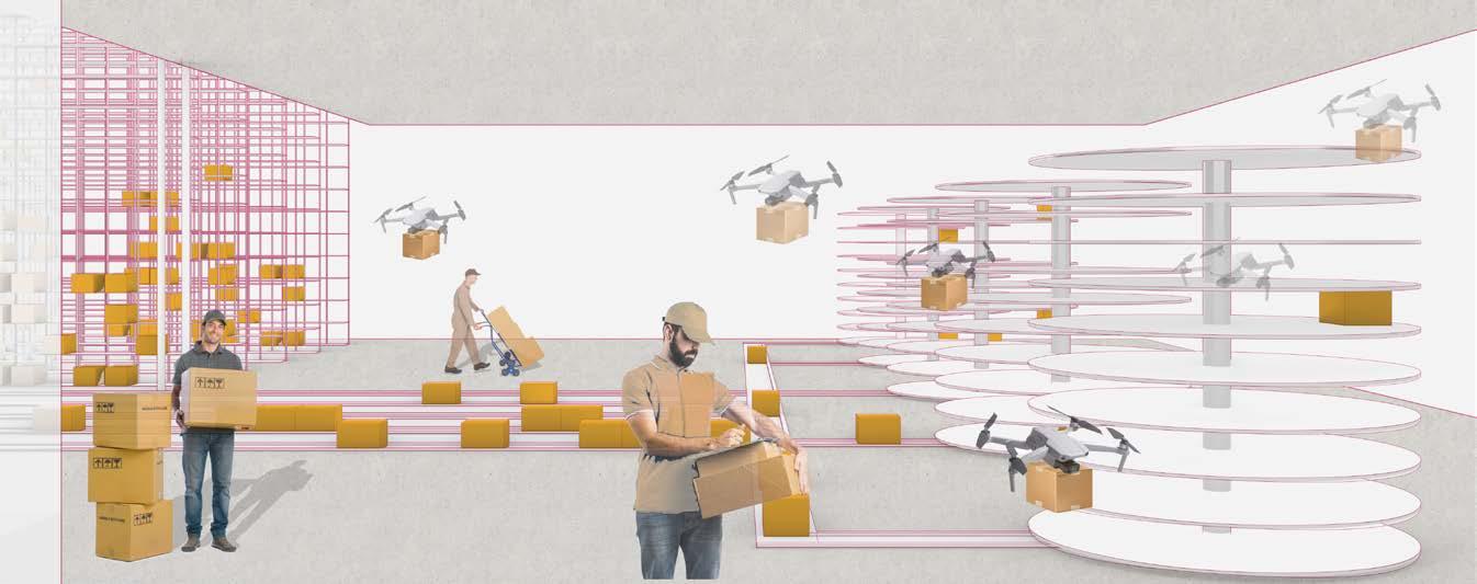
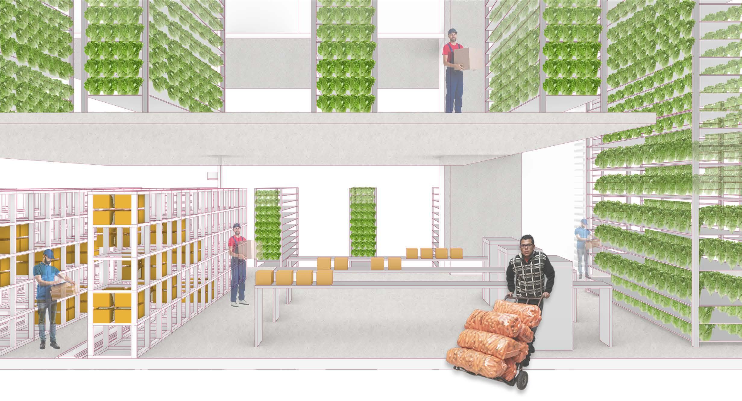
Loading & Unloading Open Food Market Vegetables Cultivation Center Temporary Food Storage Input Food Storage Food Distribution Center
02 We, The Village and The City.
Self-organized way to Renovate Urban Village
Location: Wuhan, Hubei, China
Time: 2022.1-2022.5
Individual Work
Urban villages in China is a tricky urban issue because its aggregation of low-income and unemployed people, its complex land-ownership disputes and its shabby environment. Meanwhile, demolition of urban villages and relocation of the people inside has led to even worse social impact. This project seek to use DAO, a blockchain based new orginization way to improve social and physical environment of urban villages in a self-orginized way, with fully respect to their own creativity and lifestyle.

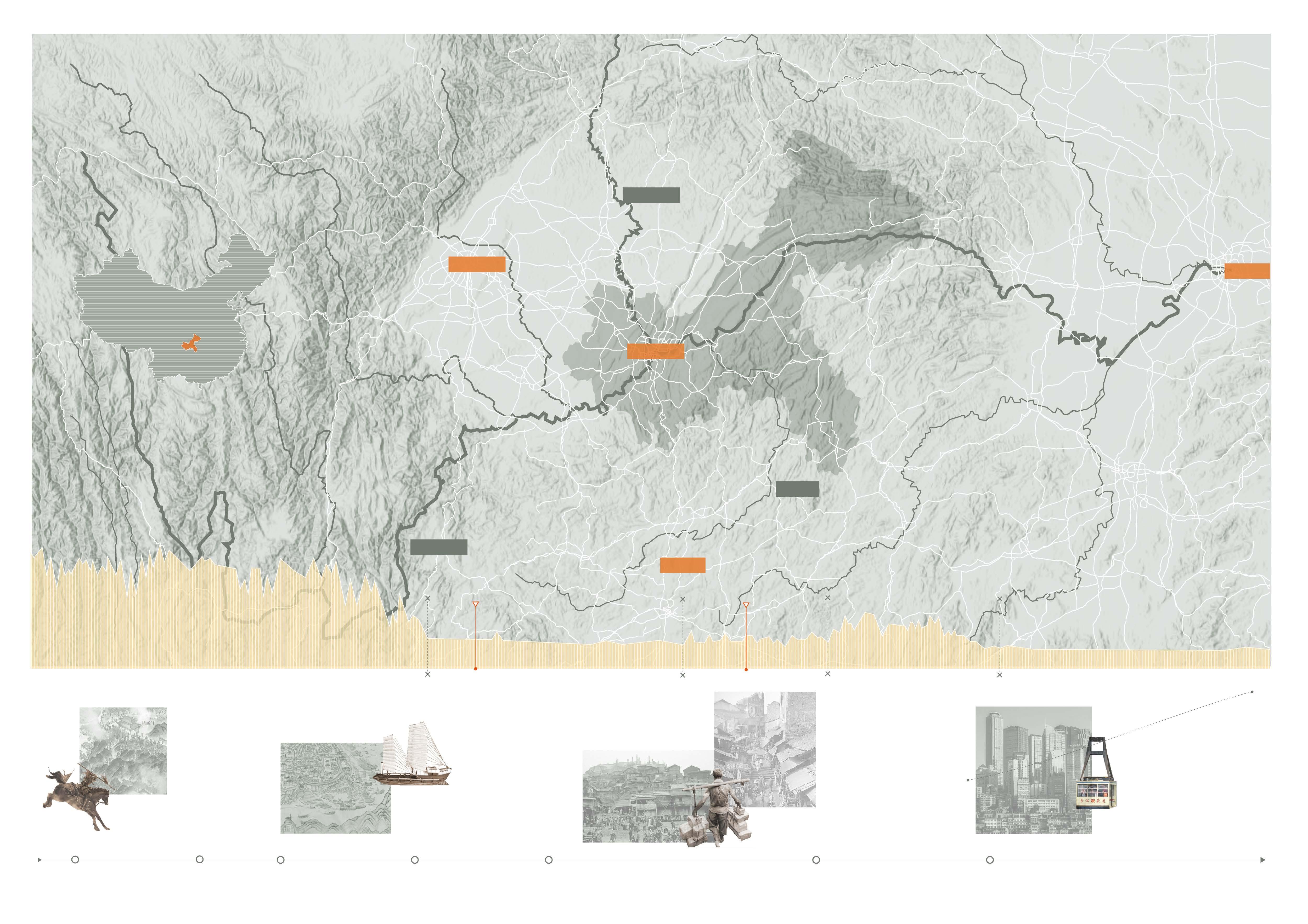
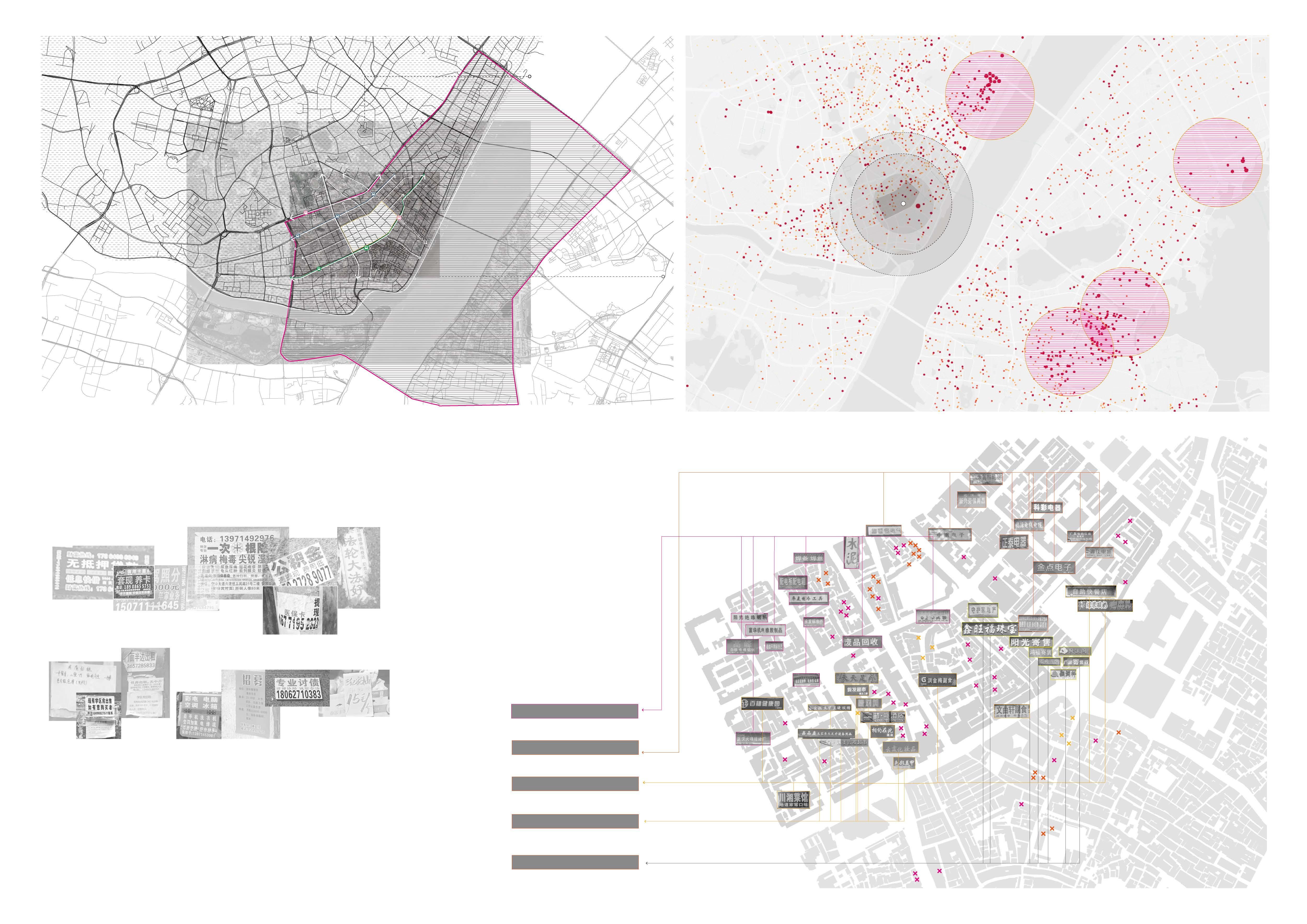
Urban Village’s Distribution in Wuhan
Wuhan’s urban village area is 25% of the whole city’s construction land area, covering about 195km²area.
Urban Village refers to countryside areas which are still resides in urban areas. As urbanization accelerates, many original villages disappear and turned into urban area, the remaining villages are surrounded by high-rise buildings.
Urban Village’s Distribution in inner cycle of Wuhan
There are 162 urban villages in Wuhan, and 56 of them located in central Wuhan (within the third circulation line)
34% outside 66% inside outer ring
urban villages located in central Wuhan covered most of area of urban villages, account to 66% of the total land area.
Rapid Urbanization
From 1990 to 2013, Wuhan’ s urban edge continuesly expand itself to new extent. In 20th century, this access accelerates extremely.
3.8% up 10.9% up
1990
Urban extent of Wuhan: 30,347 hectares
2000
Urban extent of Wuhan: 44,273 hectares
2013
Urban extent of Wuhan: 183,723 hectares
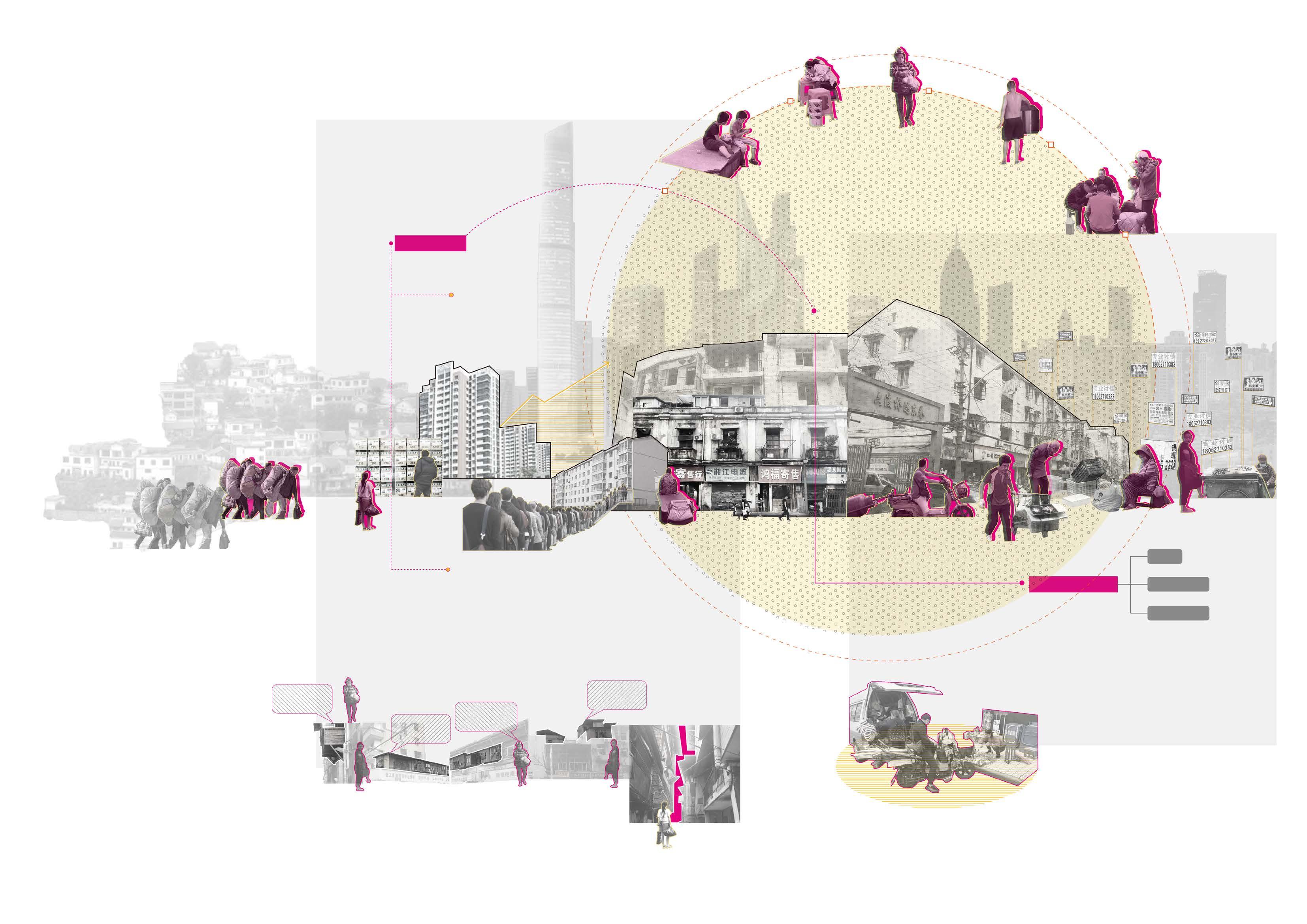
Many “motorcycle taxi” drivers live here and wait for their guest at road junctions.
Young white-colar workers working nearby live here for inexpensive rent.
People like to eat by the road.
Many buidlings here are of poor condition and the government want to tear them down for new development.
Hiding in the narrow alleies, there are plenty of long-established famous restaurant with the most authentic local taste.
How Does Urban Village Generate How Does Urban Villagers Change as Urban Village Generate
A village are surrounded by vast farming land, people who live here are farmers living by harvesting land.
As the city began to grow, it engulg in the village. Roads envelops the village and occupy farming land to new use.
As the city began to grow, it engulg in the village. Roads envelops the village and occupy farming land to new use.
Cities continues its growing process, more and more people are attracted to urban areas. Urban villagers would add new constructions to existing buildings to provide more houses and earn more money.
The process would repeat itself and urban villages became more and more in cities.
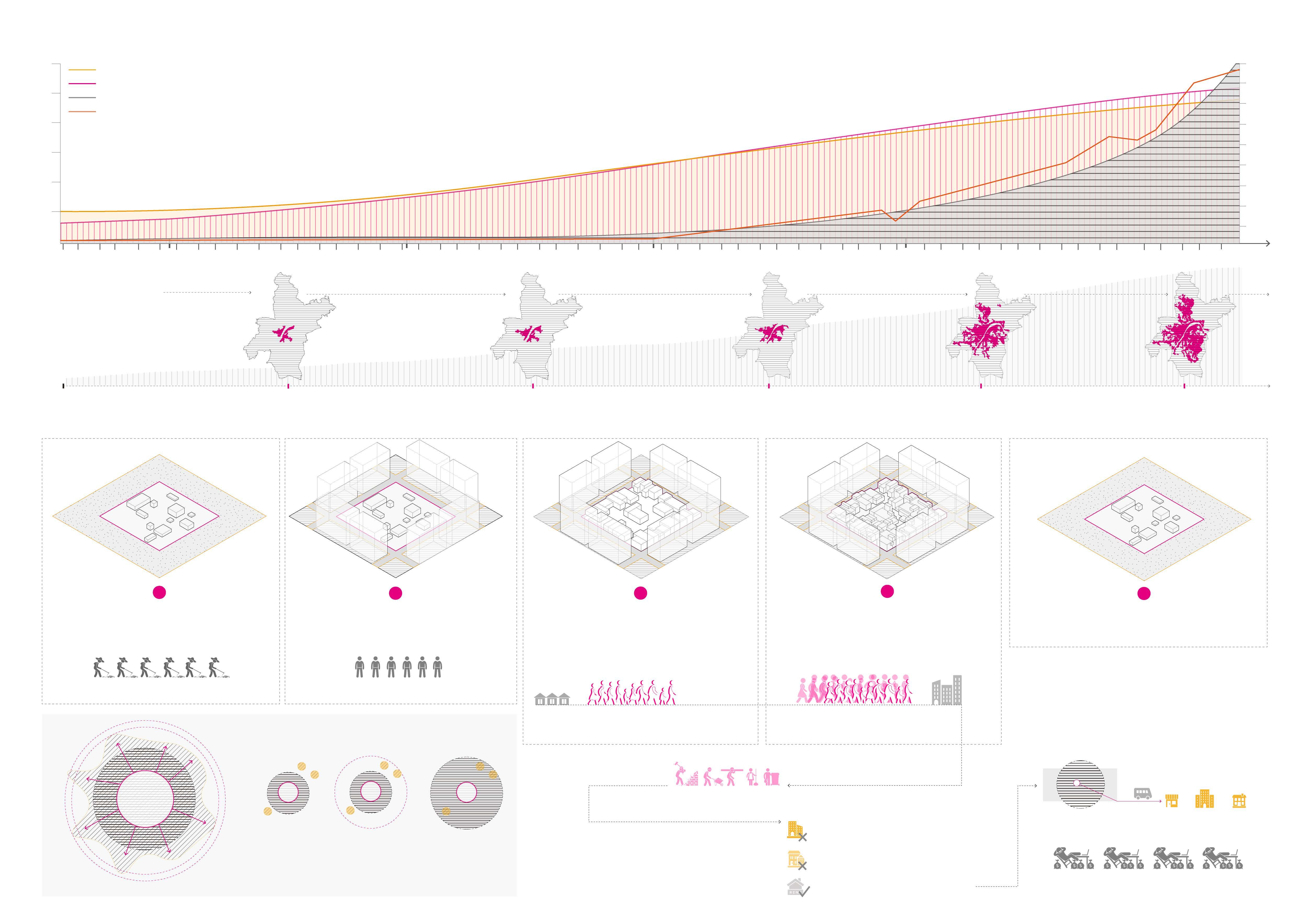
farmers farmers without land
new-comers from rural area
People in rural areas are attracted to rising urban areas to seek for jobs and ways to earning money.
new-comers become more and more become informal new citizens
urban villages
engulfed by
villages
Due to their rather low education level, they can only find low-paying jobs with poor wages.
cannot afford formal commercial housing
not enough affordable housing provided by governments
rent apartment in shabby neighborhood
shops works schools
located in central part of the city convenient to transport to shops, works and schools.
Original urban villagers would seize the opportunity and rent their houses to new-comers to make a forture
1978 1990 2000 2010 90 80 70 60 50 40 30 20 10 12 10 8 6 4 2 The Urbanization Rate of China The Urbanization Population of China China’s GDP Commercial housing sales (100M) (%)
1978: 17.9% 1990 26.4% 2000: 36.2% 1949-1978: 10.6% Population Urbanization Rate: 2010: 50.27% 2020: 63.89% Area of Built District Core Urban Area New Urban Area Village Core Urban Area Urban Area expands Villages
urban
urban
1 2 3 4 5
Why Urban Village appear-Urban Expansion
are
areas, villages became
The site locate in the “two rivers and four banks urban core area” in Wuhan, the most geo-centrial area in the city.
While the land value of this area fits no well with its location and its significant city role.
The first area to open the trading port to commercial trade and led the transformation towards modern city in Wuhan.
Site Dilemma
The site locates in the most prosperous and most central area of the city
Wuhan Inner Cycle
Site Problems
Unsecured
The drawbacks that pull this area from corresponding land value and its futher development
Apartment for rent
In the adlet patched around in the village, there are plenty of ads advertising about industries which are illegal or not under legal supervision.
Debt
Low-end Business
In a typical urban village, the business and industried here are low-end. It’s mostly run by a family and the scale is small shops.
Hardware Store
Outlanders
Renting ads are everywhere around urban village, it’s assuemed that this is because there are plenty of outlanders who are in nead of temporary residence.
Recruiment ads
Poor Living Standard
Recruiment ads says they are hiring people at the salary of a low level in Wuhan. Also, the prices of groceries and meals are also low. We assueme that people live here lead a poor life.
Electronic Accessories Shops
Vice Restaurants
Barber & Beauty Shops
Pawnshops
Cult
Loan Illegal financial motion STD clinic
Ungerground Industry
collection ads Price of groceries
Wuhan Housing Price Map
Site Problems
New-Citizens’ Problem:
The problems and dilemmas new citizens encountered during them trying to fit in the city can be summerised as the “new-citizens’ problem”, mainly about the housing problem and the employment problem
Housing problem
Lacking of money, their optimal choice is to live in urban village where has a lower living outcome
Commodity Housing
Commercial residential buildings’ prices are rising dramatically due to citis’ development. The prices are way too high compared to what the new-comers could afford.
children playing
They have gradually formed a well-operated social system,While due to its nature as an acquaintances society and out-comers’world, it’s difficult for them to connect well to outer communities and the whole city.
Urban village
Low-income groups
New-Comers
Urban villages are new-comers’ first resting place in a city, and home to low-income groups
Policy-related House
Supply of policy-related house decreases one year by one while new-comers continuely rush into cities. The needs cannot be met and most of new-comers don’t have access to policy-related houses.
Extra space to store groceries!
One more room to rent!
More space for my kitchen!
Crime
Employment problem
Drug Dealers
Prostitution
New-comers lack the education background and specific skills job market needed, they can only find job in informal market or start a small business themselves, which has rather low income.
Bedroom for my employees!
Lunch by road Shopping from road-side market Shopping from road-side market
road
Family dinner together by
Every one change the neighborhood as they like and everyone wants to optimiz their own benefit and gain more favor. Therefore the public area are squeezed dramatically and environment are terrible.
Current underground industry, especially prostitution are under no supervision and has no security, which is harmful to both prostitutes and urban villagers.
Extra
Provide more well-designed housing for low-income people in urban villages to satisfy their needs to live with dignity.
Community forming
Form a community with urban village to meet their needs to be connected to this place and their neighborhood.
Provide
Provide formal job opportunities with decent income and legal securities so that villagers could feed themselves with their own hands with insurance.
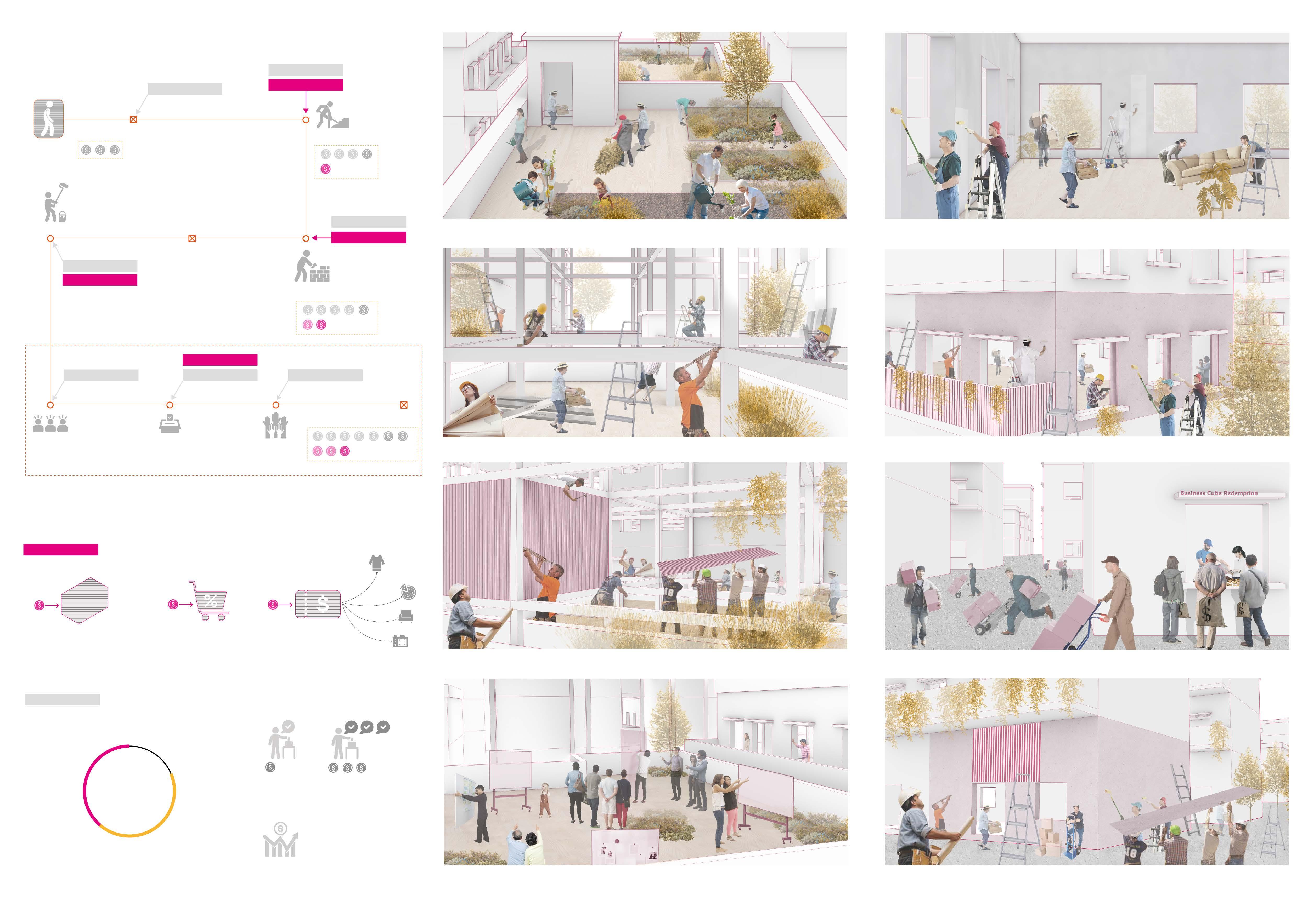
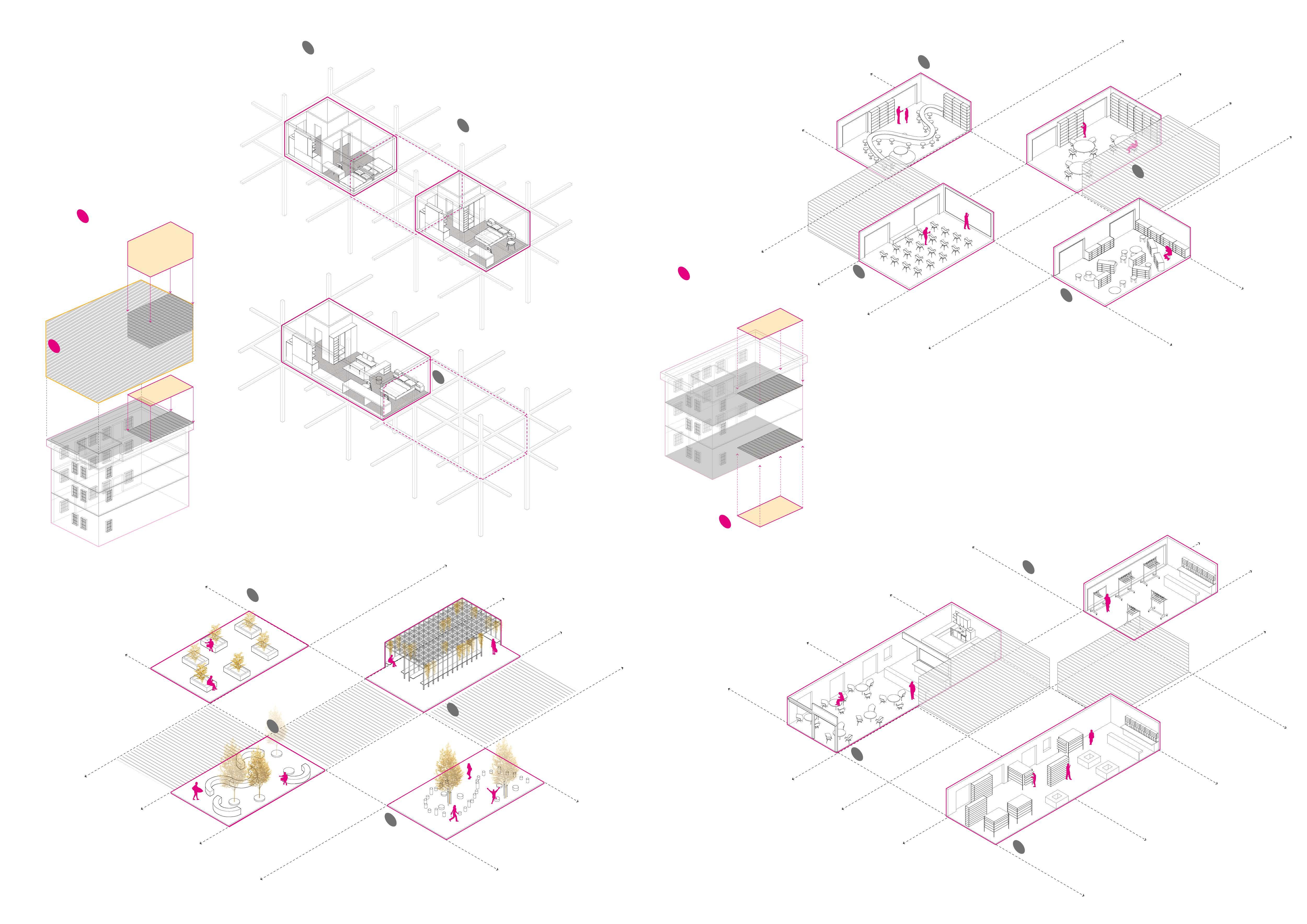
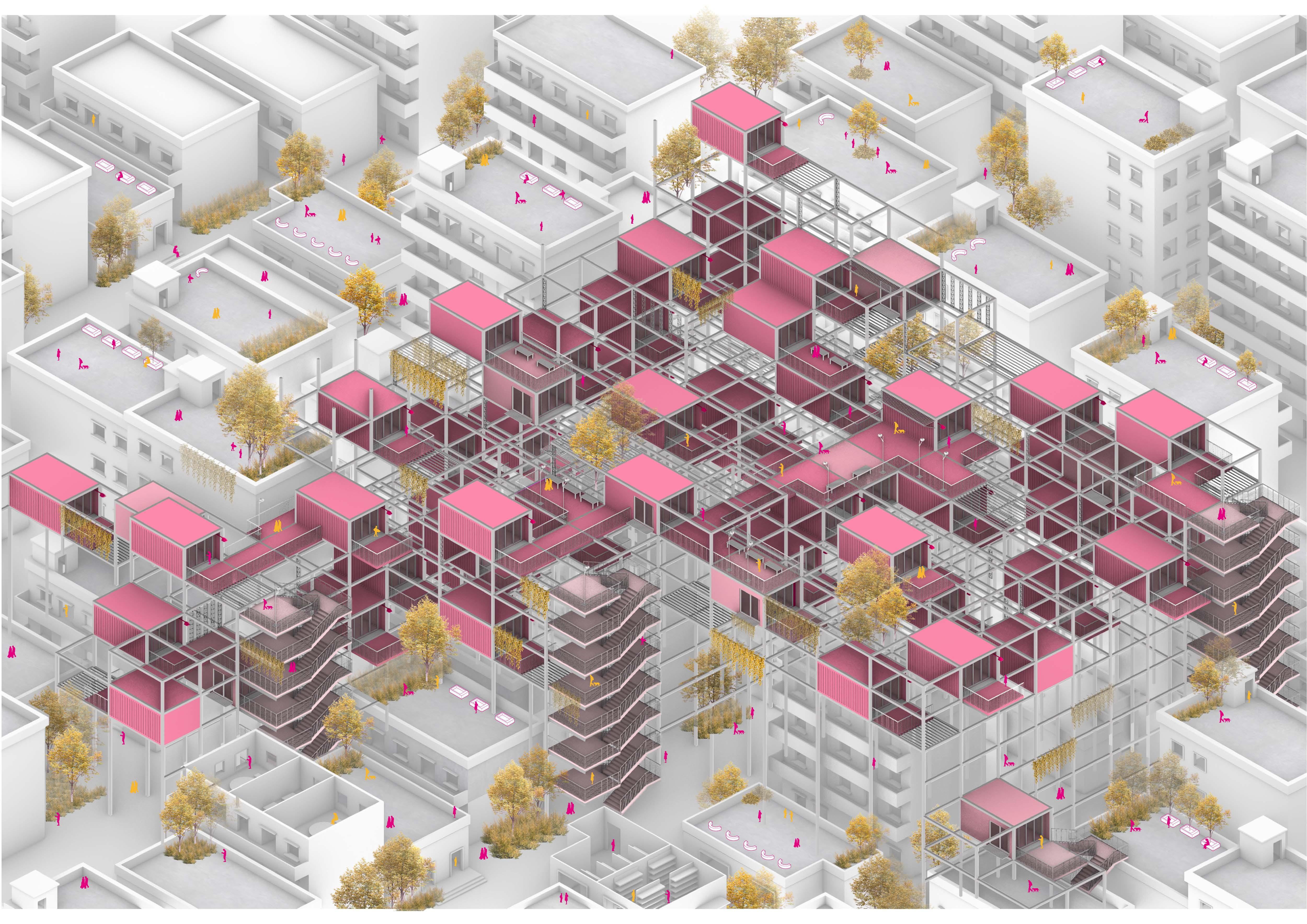
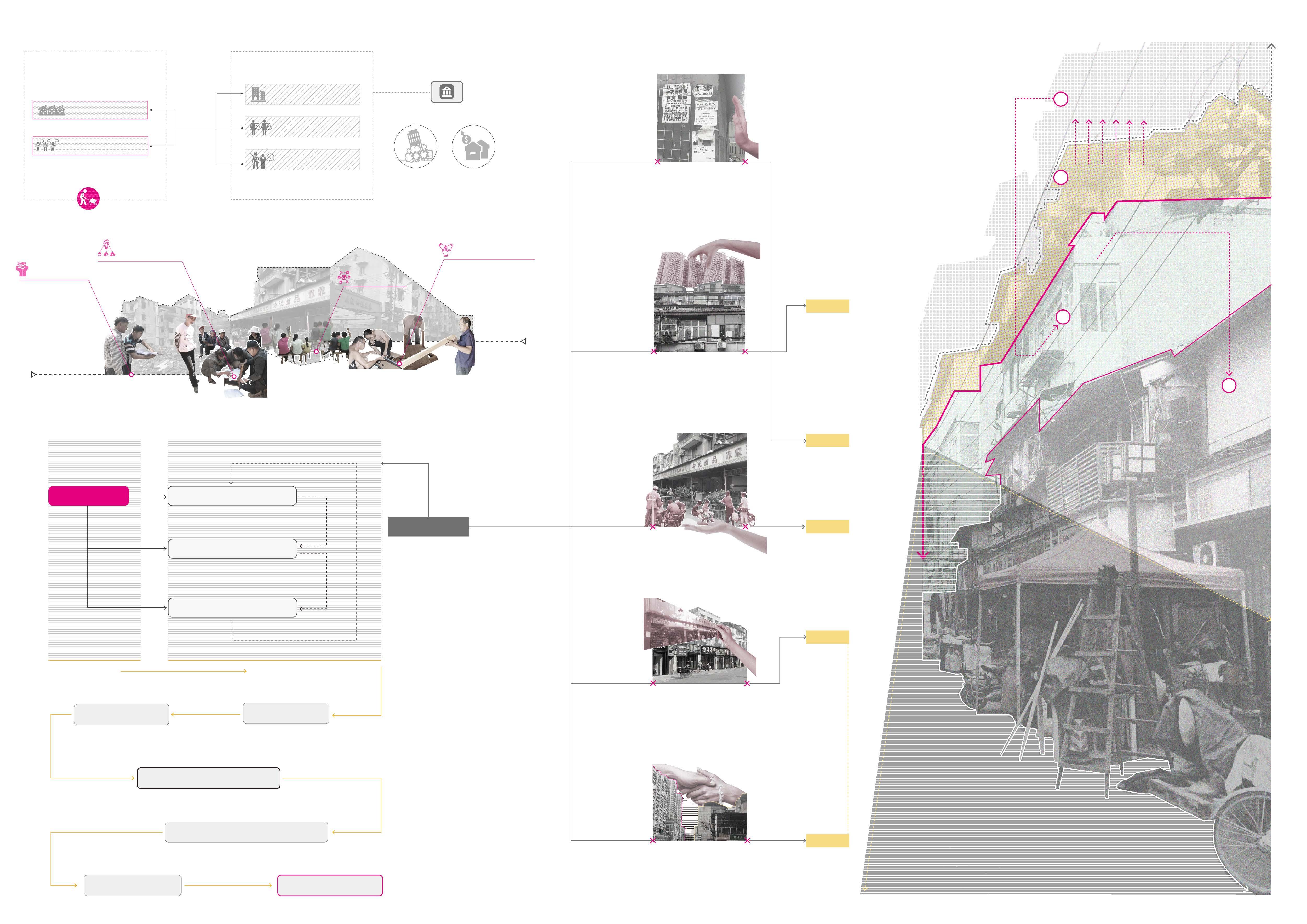
Instead of tiring down existing buildings of urban villages, we could construct new ones from above
Work as the new residential area’s entrance floor and new-residents’ public activity space.
Village
Form a community with urban village to meet their needs to be connected to this place and their neighborhood.
Construct new
from the original top floor on to provide extra residential space
As people start to live above, they need more public activity space besides top floor, they would explore down and gradually transform current shabby village building to their new space, which benefits formation of a community.
Small business adds more diversity and glamore to the city and would attract more and more citizens to come here and prompt communication between urban villages and the “outside world”
Transform current village building into new public space for community activities
Provide more shops and tents for villagers to start their own business.
Public supervision from above make underground industries such as prostitution under supervision therefore more transparent.
Construction Execution Prosocial Behaviors Promoted by system and mechanism designed by government and designers Solve current problems Form a well-operated communty temporary goal Develop awareness of self-organization incentive Incoroperate a DAO Decentralized Autonomous Orginization Self-Govern Community ultimate goal STEP 2 STEP 1 STEP 4 STEP 5 STEP 3 Housing problem Employment problem using Decentralized Incentive Policy Core Problem Appeared Problem
Problem Solution ——Using Self-orginzed System
Urban Villagers Participants Decentralized Incentive Policy Reward System Are Initiate Support Manupulate Determine Incentive Government Set up goals Support
Industry
Self-organize System Mechanism
Concept Strategy
Underground
Housing
job position
top floor to public space
is City Transfer
housing
1 2 3 4
Perspective of Government
Living environment Social Appearance Illegal Industry
Villagers Spot Problems Villagers Brainstorm Solutions Step 1 Step 2 Discuss and Negotiate Launch the project together Step 3 Step 4
Demolition Gentrification
Perspective of Citizens Villagers form a self-orginization system to tackle this issue.
Spatial Design Strategy
Analysis of Site Issues
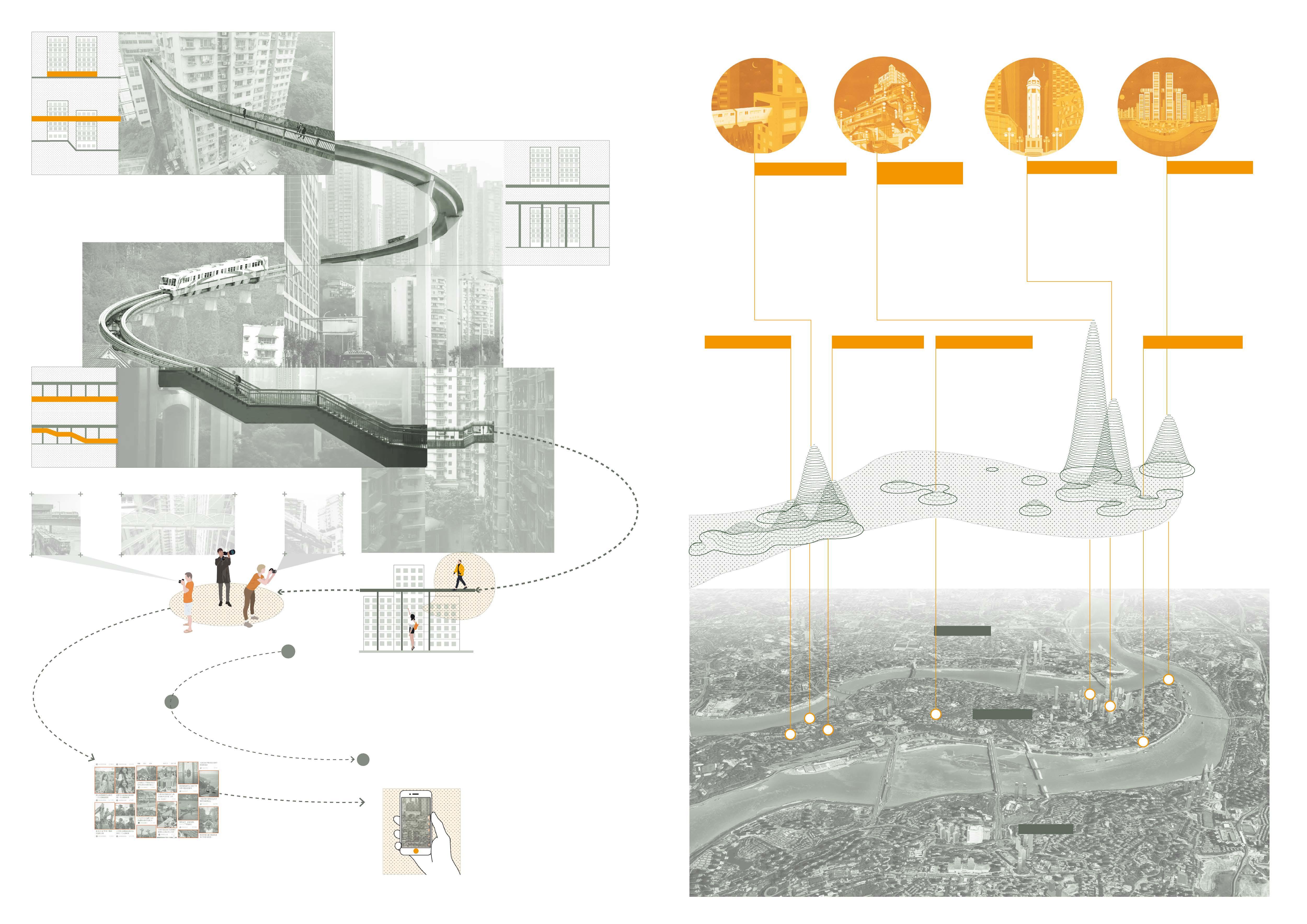
Liziba subway station suddenly became extremely popular because of its unique scenerio that a subway train drives through a building
Attract People to Come
Videos and blogs about Liziba Station got more and more attention, people are attracted to the spot to take a glimpse at this famous place.
The visitors here are amazed by the unpredicable scene, some of them upload their photos taken here onto the self-media. It also attracts more people to Chongqing and Liziba.
Impediment to Residents
straight-lined distance: 1100m
The narrowest and steepest part of the island
straight-lined distance: 316m walking distance: 1900m, 43min
Liziba subway station
They find out that although it’s very short distance to the other destination, they need to walk for a long distance mountain roads due to its steep mountainous terrain.
To save time and energy, some visitors would take a shortcut through the residential buildings They route constantly interve with dwellers’ daily route and it’s difficult to garantee the community’s serein atmosphere.
Affects Residents' Lives
To get a better view of the scence of Liziba Station, tourists flood into residential buildings to take pictures, which affect residents’ daily lives.
Searching for Next Travel Destination Commuting

When they finish taking various photos in liziba and continue their exploring around the city, they began to search for nearby attractions such as No.2 printing factory and Eling park.
Impediment to Tourists
straight-lined distance: 299m walking distance: 1500m, 33min
From Liziba Sation to No.2 Printing Factory two top tourist attractions in Chongqing, the only way is to walk through the Eling mountain for 1500m, taking about 33min, though the straight-lined distance is 299m The height difference between Liziba Station and No.2 Pringting Factory is 270m, which means the commuting route is mostly strenuous mountain road.
straight-lined distance: 299m walking distance: 1500m, 33min
The Eling Park
Become Popular on Internet
Secondary Propagation
inconvenience
the Inconvenience
a Shortcut by Crossing Residential Buildings
Discover
Take
No.2 Printing Factory The Eling park Liziba subway station No.2 Printing Factory 270m Residential Community 0m Liziba Station No.2 Printing Factory Eling Park
80m 120m 140m 180m 180m 180m
Concept Strategy and Form Generation
01.Current Situation
Culture and Creativity District
Site of former No.2 printing factory shops&workshops&food and beverage
residential buildings &local communitys
Residential District
Residential buildings &local communitys
Function Assignment
[Communities]
Liziba Tourist District
Instagram-worthy location
residential buildings &local communitys
To the nearest subway station 1.5km, 18min by walking.
To the nearest bus station 1.4km, 18min by walking.
1
02.Problems
Sitting at the top of Eling mountain, it’s hard to access by all kinds of transportation.
03.Proposed Strategy
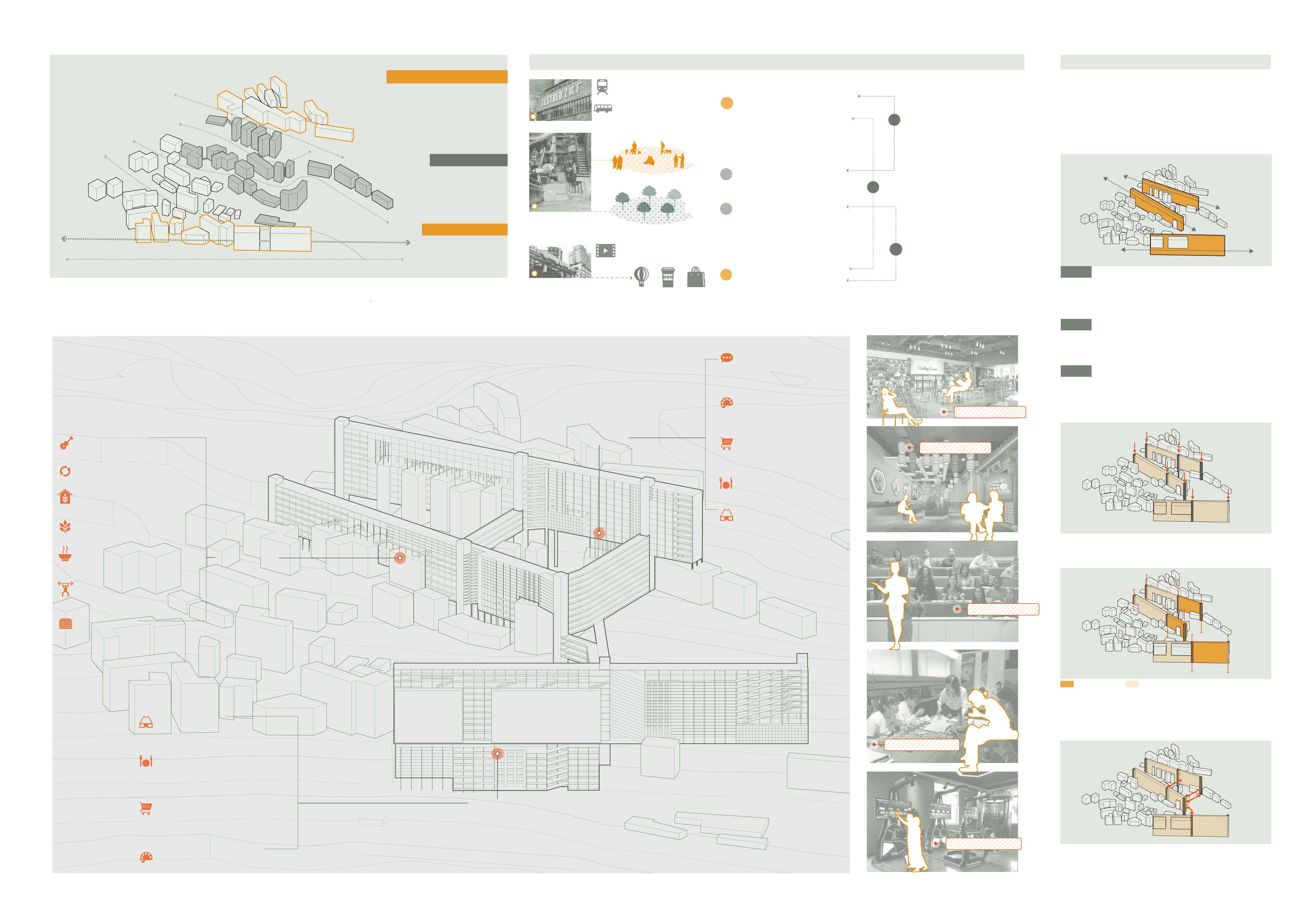
01. Line the buildings of similar functions and same height to increase communication opportunities.
Testbed 2 did not connect well with local communities which provide the prototype of real life in Chongqing city.
Lack of abundant space for public activities and community gatherings.
Lack of green space and leisure space.
02. Extrude the line into walls to expand extra spaces for tourists and residents.
The only activity is taking photos, which took less than 30min.
Lack of multiple attraction forms for vistors to stay longer time and exprience the site deeper.
Two top attractions are merely 300m away, while the visitors need to walk about 30min to transport. 3
Visitors trying to get a better view of Liziba would intrude in residents’ appartment buildings ,which caused residents’ inconvenience and discontent.
[TESTBED 2] Lectures and Exhibition
[TESTBED 2] cultural and creative products workshops
A-wall dig deeper in Liziba Station’s cultural phenomenon and create a series of experiencing service to extend tourists’ time in this area.
B-wall provide more space for residents to communicate with each other and conduct various activities.
C-wall provide more leisure and activity spave for residents and more experiencing space for tourists. Allow tourists to get to know about local communities.
TESTBED 2
[Communities]
Barter Market
[Communities]
Community Garden
[Communities]
[TESTBED 2] cultural and creative products gifts shops
[TESTBED 2] Food and Beverage
[TESTBED 2] VR Exprience House
03. Plug in the vertical tranportation system
[Communities]
Music Festival & Movie Night Communities
Home-made Food Store
[Communities]
Gym
Chess and Cards Room
Family Garden [Communities]
Community Library
For tourists For residents
04. Distinguish between visitor areas and residential areas
[Liziba Station]
VR Exprience House
[Liziba Station]
Food and Beverage
[Liziba Station]
cultural and creative products gifts shops
[Liziba Station]
cultural and creative products workshops
Liziba Station
05. Connect three walls through horizontal transportation systems between vertical systems
No.2 printing factory
2
2
1
1
2 A A B B C C
Residential district Liziba Station
Liziba Bookstore
Restaurant
Cultural Lecture Hall
Creativity Workshop
Gym
Routes of Tourists and Residents
TESTBED 2
Another tourist attraction,mainly focus on providing a cool and unique community for young artist and social enthusiastic people to engage in producing their own thoughts and show it.
Graffiti district
Provide an opportunity for youngsters to show their unique thoughts and proposals through painting. Also this can become another tourist attraction.
NO.3 Wall-TESTBED 2
NO.2 Wall-Residential
The old building space cannot satisfy residents’ need so the space is enlarged by constructing the no.1 wall and on the roof the residents can hold community events such as large-scale bargin market and music festival,etc.
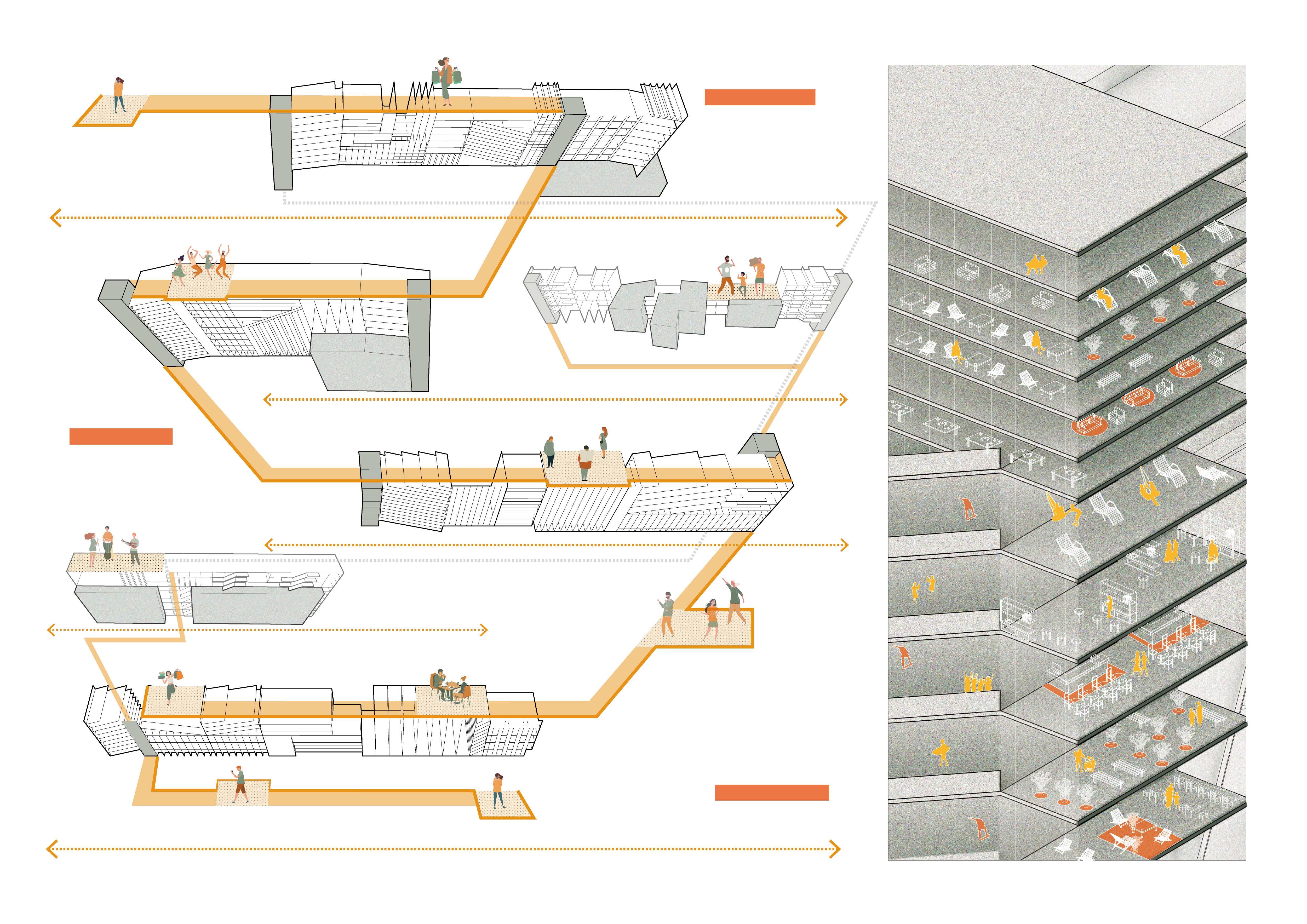
In the no.2 wall, set a number of scenes in order to use space to demonstrate the city’s unique mountainous terrain and the derivitive charactors. It mainly focus on the everyday life of common Chongqing people and how they act in the city.
Eling Zheng Road
The extra space is spared for familied living here to participate in a variety of community activities such as workshops to recognize the neiborhood or to just paint a picture of the whole family. It can benefit the family relationships.
The subway station and subway line seperate the visitors and residents so that their route can be divided and wouldn’t bother each other.
Chongqing Subway Line 2
Besides the industry of culture and creativity product, The no.1 wall also need to develop other various commerce to form a market and satisfy the visitors and customers’ need.
Jialing New Road
Guihua Yuan Road
In the walkway between the no.1 wall and the no.2 wall, sets a visual tech walkway showing the charactors of Chongqing City, so that the web celebraties could take pictures here and attract more and more people to come.
Developing the industry of producing the derivative products of Liziba Railway station and advertise it so that the visitors would notice about the cultrue and creaticity product and the product thus helps to prosper the Liziba station.
Hundreds of visitors rush to Liziba station to take a photo or selfie of the wonder scene of the subway train drives through the building.
NO.1
Bingjiang Road
Wall-Liziba Station
Prototypes of Public Space For tourists For residents
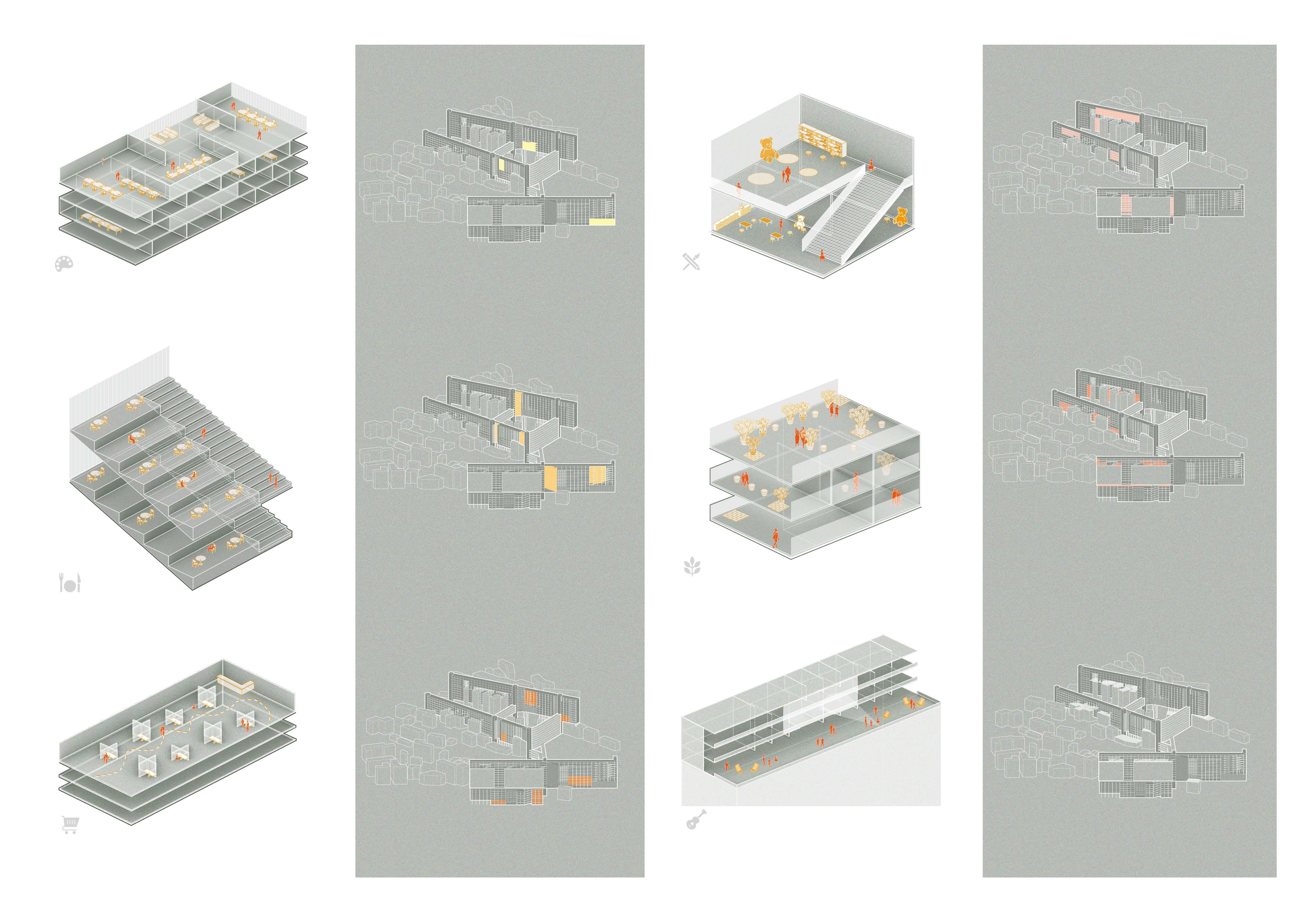
Cultural Creativity Workshop
Workshops in Walls for tourists provide a space for tourists to engage in crafting and making one’s own cultural creativity products. It allows tourists to dig in local culture deeply and utilize their creativity to express their own understanding of the particular space or scenerio.
Food&Beverage for Tourists
Restaurants and cafes provide a space for tourists to enjoy local foods and drinks. It’s a unique experience espetially when one enjoy Chongqing’s food in a mountainous environment.
Gift Shops
Local cultural and creativity products are displayed for shopping in Gift shops. Tourists could select their favourite products here.
Children’s Area
Children’s area provide children with a space to read, play and have extra-curriculum activities. This space would hold lectures and reading sharing festivals from time to time, offerring children an opportunity to explore the knowledge world. Also, it contributes to bonding families when their children playing together.
Family Garden
Family garden provide a space for family members to set a sigular space to plant their plants. During planting, families can show their family culture through their plants. Also, these plants can improve the community environment.
Music Festival&Movie Night
The roof would be a natural open space for community music festivals and movie nights. Residents could gather at the roof to enjoy a leisure night with their neighbors.
Spatial distribution Spatial distribution
04 Post-industrial Paradise
Adaptive Reuse of City’s Industrial Heritage
Location: Wuhan, China
Time: 2021.3-2021.6
Individual Work
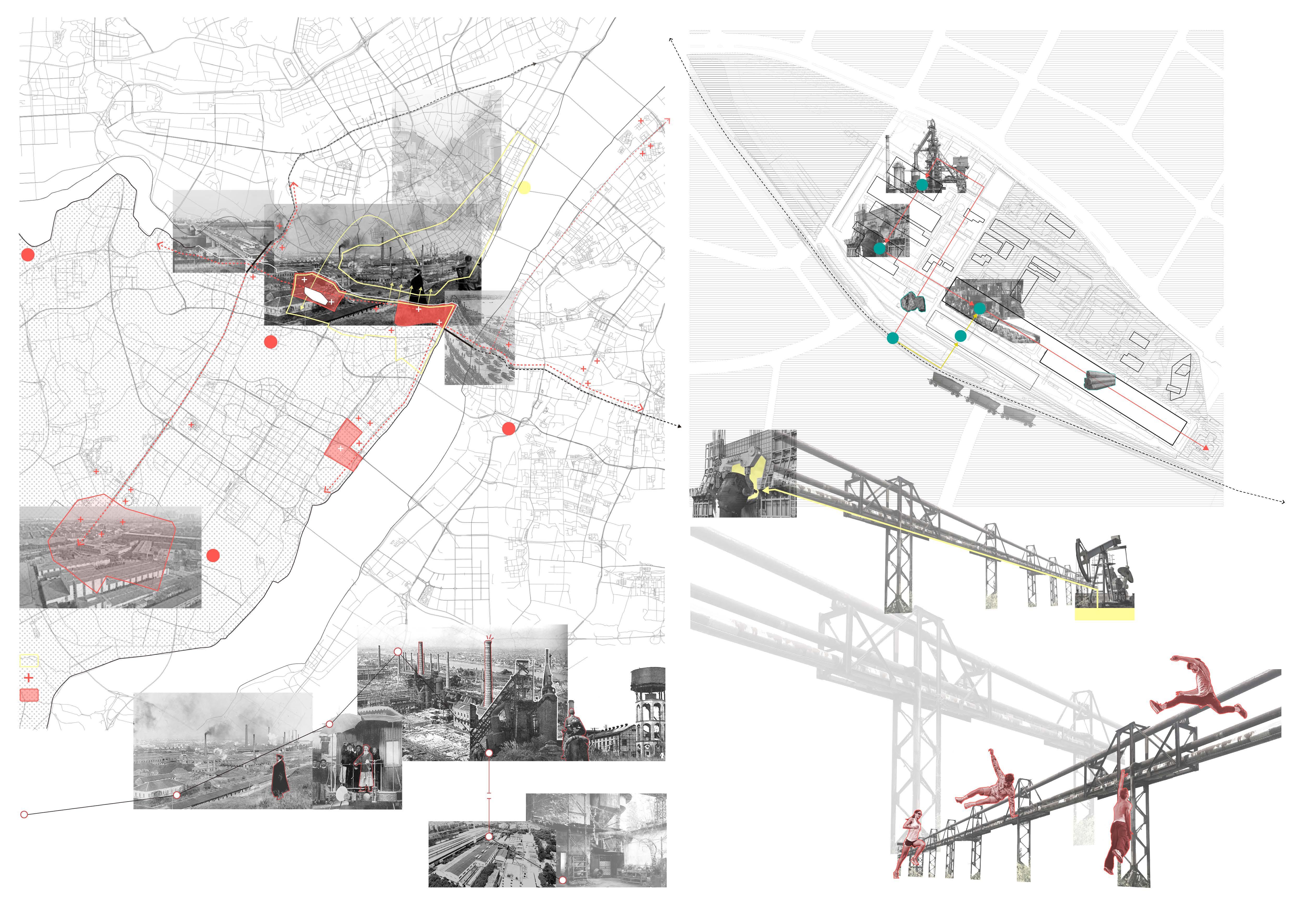
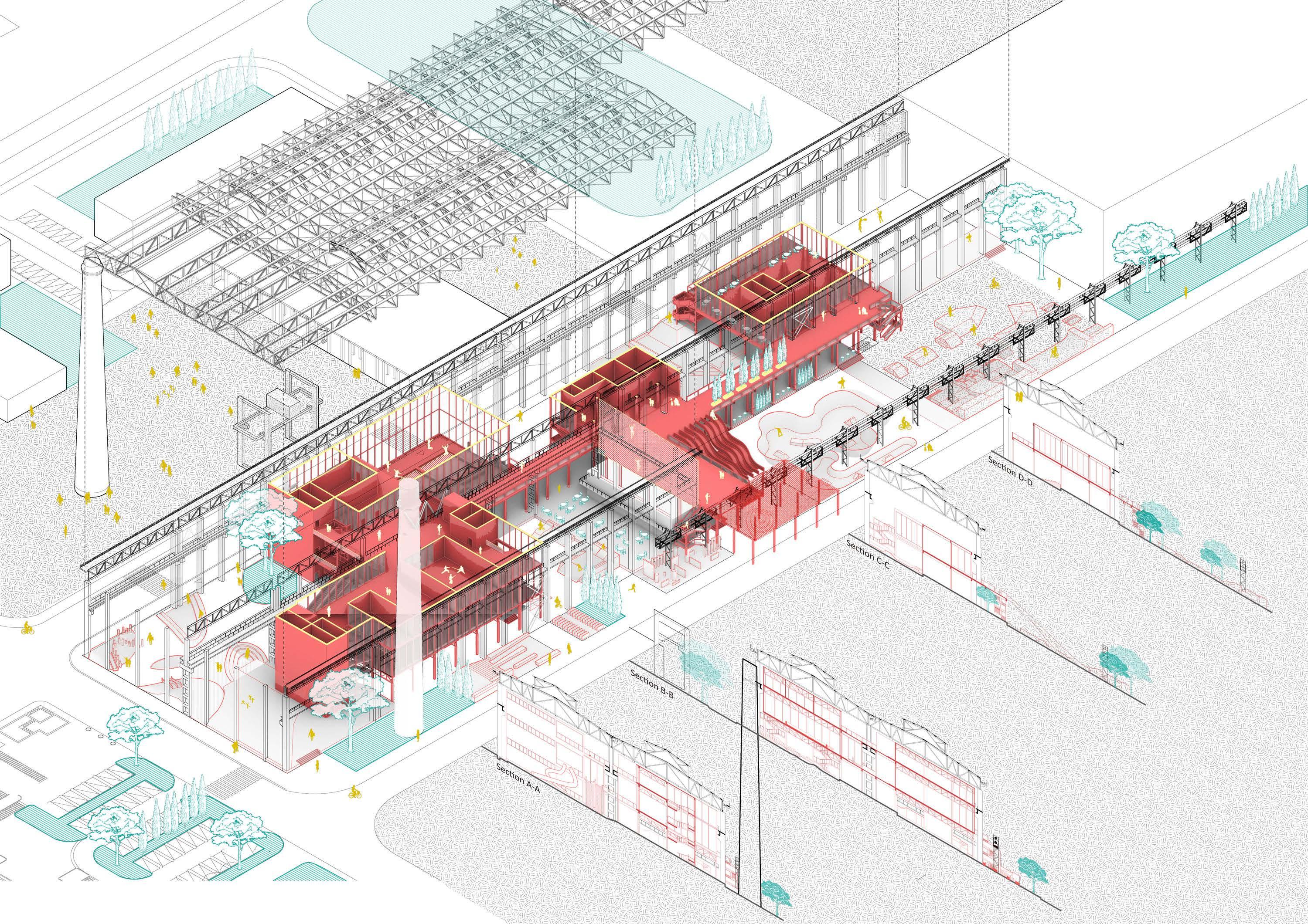
Hanyang Ironwork used to be the most productive steel plant in this country, while after entering into 21st century, the factory was shut down and the site is abandoned. This project proposed a brand new plan to reinvent the factory into a paradise, an amusement park. The previous architectural elements and infrastructures’s meanings are reconstructed and are assigned with new meanings of modern perspective.
Regional Historical Analysis
1978-
1894
Factories Industrial Process before Shutting Down
In need of large amount of iron and steel to construct railroads. The government choose Wuhan to build a ironwork.
Factory Historical Analysis
Raw material shipping in
Factory Reuse Proposal
Steelmaking furnace
WWⅡ Factories are exploded, equipments are kept.
3.New Interpretation
- Amusement Paradise
The abandoned factory have structures and space perfectly fit for amusement use. 1953 Rebuilt the factory 1985 Manufactoring
2. Meaningless Structures
After steelmaking ceased, the factory nolonger undertake any production functions, it became an assemble of meaningless structures.
1.Original Use-steelmaking function
The former petroleum pipeline could be used for parkour and climbing, etc.
2 3 5 4 1
1913- Xinhai Revolution Hanyang’s city functions besides industrial manufacturing are replaced by Hankow. In the period Hanyang continuesly decline and fall.
1957- Yangtze River Bridge Built The bridge connect Hanyang and Wuchang, which allows Hanyang’s railway and thus iron industry to expand eastward.
2000- Zhuankou New Industrial Zone Wuhan and Hanyang’s manufacturing industry migrant towards suburban areas and established new industrial zones for industrial production.
Zhiyin Bridge was Built Connect Hanyang and Hankow, allowing Hanyang’s industry expand westward and northward
Major Industrial Zone Major Industrial Factory Urban Functional Area HanKow HanKow Yangtze
Zhiyin Bridge Wuluo Road JingzhangRailway Longyang Avenue Hanyang
1891 Start constructing 1893-1896 Operating Trial & Error 1908
1938
- Late Qing Dynasty Foreign Affairs Movement requires Wuhan to build the Hubei Arsenal and Hanyang Ironworks. It forms the first industrial zone in Wuhan City.
River Bridge
Ironwork
Asian’s Largest Iron and steel conglomerates
1890
Petroleum Pipeline
fuels
Site Railway A D E B C Iron Ores Threaded steel Blast furnace- Ironmaking Converter Steelmaking Iron Iron Ores Steel Billets Output ProcessedSteels Steel Rolling Storage
Stopped The factory is abandoned
Field
1.original structure
2.Insert Boxes
Translate 4 iconic structure ourside of factory as 4 scene can be combined into extreme sports and amusement activities inside factory. Insert the boxes according to the structures’ location and assign different activities to each box.
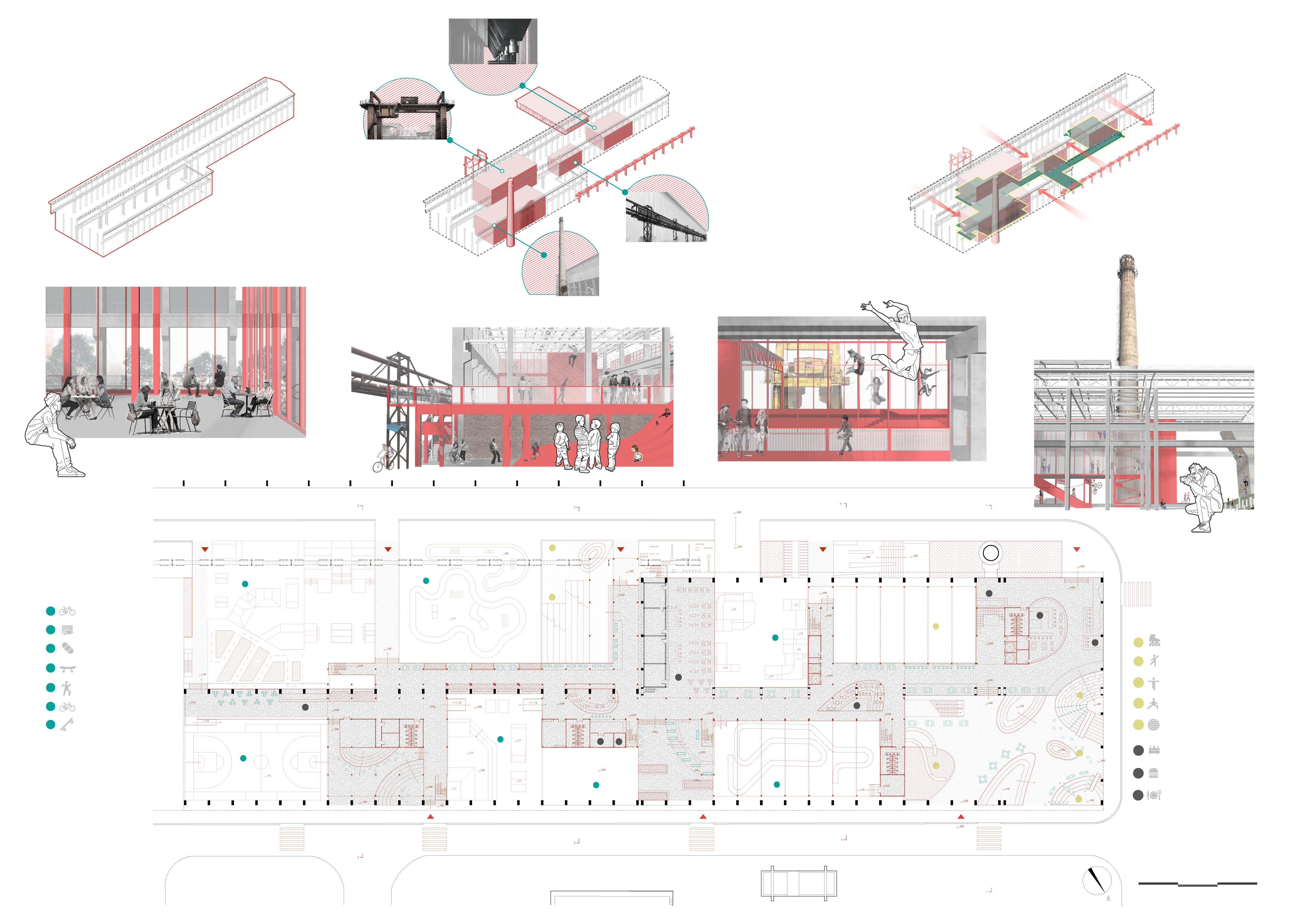
3.Boxes connection & Urban Invation Connect 4 boxes with 2 layer of paths. The architecture has no facade or walls, so everyone can casually walk into the building through 5 entrance from both sides.
Roller Skating Rink
Rock Climbing
Giant Slider Wooden Stakes Park
Sand-pit Park Information Desk Food & Beverage
Buffet Restaurant
13 14 1 2 3 4 5 6 7 8 9 10 11 12 10 10 13 13 15 13 14 14 13 14 15 0 10 20 30 m 1 2 3 4 5 6 7 Bike
Park
Street Dance Pumping
Architecture Build-up Airpark 8 9 10 11 12
Basketball Courts Bowl Skateboard
Street Skateboard Field
Track Ground Floor Plan
Hostess and Organizer of 2022 MIT City Science Summit
“ SoCity Community DAO: A New Prosocial Urban Development Process” workshop
The summit is hosted by members from MIT Media Lab city science group and City Science Lab @Shanghai. In the summit, we presented a new way to conduct urban development and urban planning through decentralized process initiated by citizens. Through well-designed workshops, participants could engage in simulated real scenerio of urban development by playing different roles as stakeholders and negotiate with each other to reach the final consensus.
Designer of Architecture Camp in "Sunners - Rural Charity" summer camp
Designer of community courses
cooperated with Sunners Social Development and Innovation Center, Beijing Municiple institute of City Planning & Design, One Take Architect.
Architecture Camp - “R Tower”
Co-curator of “Endless Me” - Aesthetic Exhibition for Rural Children (Wuhan) cooperated with Sunners Social Development and Innovation Center
We worked with Aesthetic Action Network for Rural Children to hold an exhibition of children’s works in our summer camp and community couses. The main exhibited works are “R Tower” from Architecture Camp and “Self-Portrait” from Fine Art Camp.
We worked with kids from Wuhan city to recognized and recreate our communities together through a series of community courses and workshops.
Community Courses “Cognitive Mapping”
We worked with kids from rural area to build “architecture” together in a four day’s workshop. In the workshop, kids learn, design, construct and collaborate. Constructing an architecture by one’s own hands is a way to create an indeterminate participatory open ended situation and recognize material world. Thus the architecture built is a lively scene instead of pile of material things.
Architecture Camp - “Hi Ladder”
Ancient Architecture Practice
Mapping of Puqi Town Thermal Power Plant and Adaptive Reuse Strategy Study
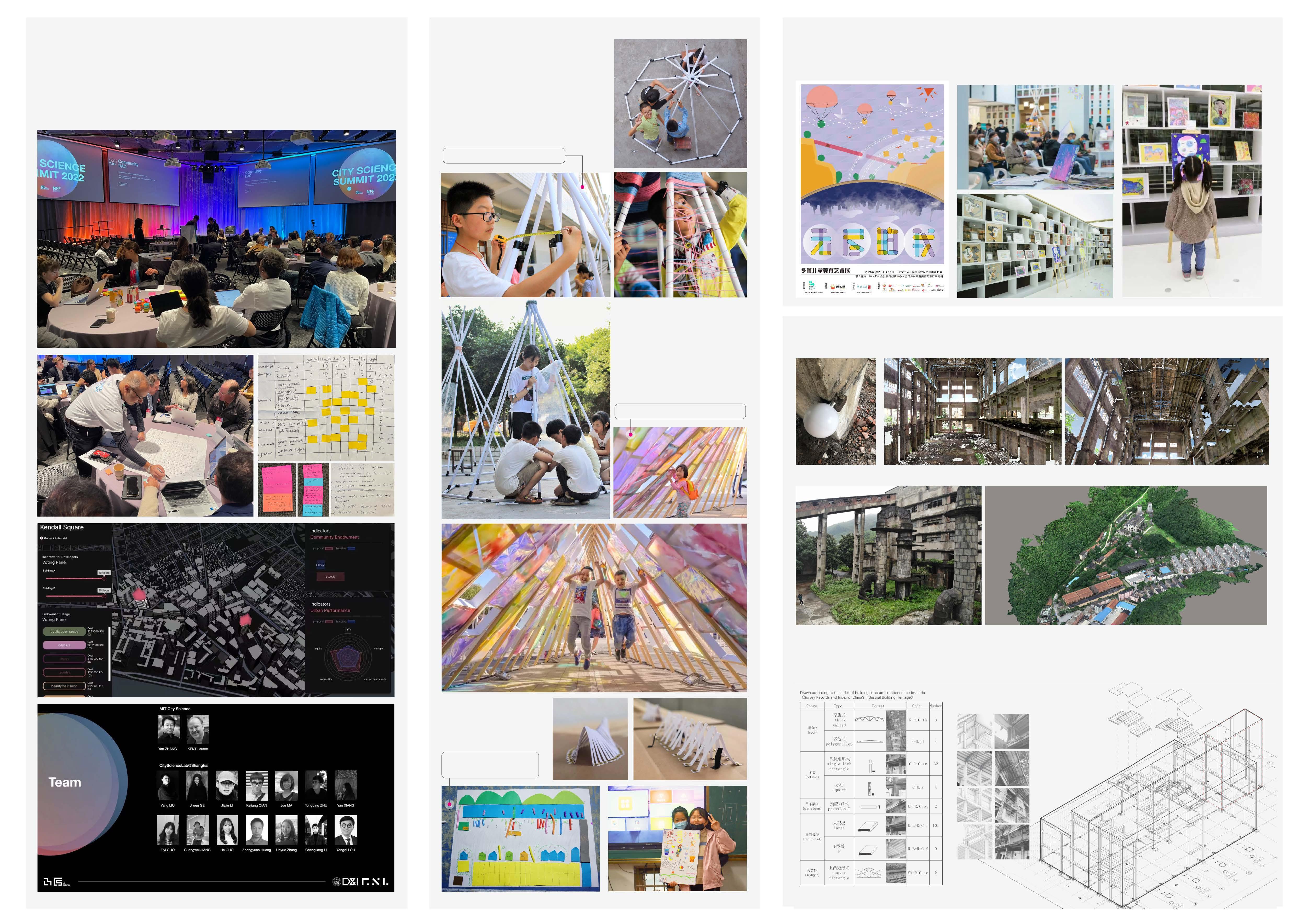
“New Zhengdong Cup” Historical Building Research Competition, 2nd Price, Team leader of 3.
3D-scanner generate point-cloud models of factory’s interior space
UAV tilt photography generate factory’s exterior and surrounding spaces
UAV
With the help of different technological tools and traditional surveying and mapping methods, we finished fine technical drawing and 3D modeling of the main factory and surrounding area. Conducting interview about the factory’s production process and the workers’ daily lives. Based on the collected information, we proposed a series of adaptive reuse proposals for the area’s future reservation or development process.
photography generated model
Summit @ MIT main venue point-cloud model
point-cloud model
Summit @MIT main venue
Simulation sandbox
Organizor team
Discussion boards
tilt


