SMOKIES GUIDE The official newspaper of Great Smoky Mountains National Park • Winter 2020–21
In This Issue
Smokies Trip Planner • 2 State of the Park • 4 National Park News • 5 Winter Driving Map • 6 Safety in the Mountains • 8–9 How to Help the Smokies • 10 Jr. Ranger Page • 11 Visitor Information • 12
Image by Bill Lea
Winter Driving? Proceed with Caution
Be #SmokiesSafe • Delay your trip
Plan ahead for road closures and rapidly changing conditions this winter
T Ha
e ag
r
L
iz
ll, E
m e r ge nc y Ma
n
Words with a Ranger I came to Great Smoky Mountains National Park in June as the park’s first emergency manager. In this role, I oversee the Smokies’ Emergency Medical Services (EMS), Search and Rescue (SAR), and Preventative Search and Rescue (PSAR) programs. One of my current goals is to increase the park’s search and rescue capacity through the PSAR program. PSAR is the attempt to prevent injuries and lost hikers in the backcountry. We do that in a variety of ways—by reaching out to educate Words with a Ranger continues on page 5
he coldest months of the year bring some of the best chances to enjoy Great Smoky Mountains National Park. With a little planning and a few extra layers, the well-prepared will find plenty to see and do even in the Smokies’ quietest season. The first step is knowing what roads will take you there. Many secondary and higher elevation roads in the park close seasonally due to hazardous winter conditions. (See map page 6.) Temperatures drop swiftly at higher elevations, and precipitation is often much more frequent and heavy at the park’s tallest peaks. Salt is not used to treat roads within park boundaries because it damages the plants and streams. One major roadway subject to frequent closure is Newfound Gap Road (U.S. 441), the main roadway connecting OUR PARK ON SOCIAL MEDIA
Gatlinburg, TN, and Cherokee, NC. Newfound Gap Road stretches 33 miles across the mountains rising to an elevation of 5,046 feet. Even though driving conditions may seem fine near Gatlinburg or Cherokee, Newfound Gap Road contains very steep grades and sharp curves and is often coated with snow and ice in winter. For alternate routes, see the back page of this newspaper. When driving on icy or snow-covered roads, reduce your speed and avoid sudden braking. Leave extra space between you and the vehicle in front of you. Use lower gears or brake very gently when you need to slow down. For current conditions, check Twitter at twitter.com/smokiesroadsnps or call 865.436.1200. For information on seasonal road closures, visit nps.gov/grsm. GreatSmoky MountainsNPS
if you are sick
• Avoid crowded areas • Maintain social distancing six feet away from others
• Restrooms may be closed, so come prepared
• Wash your hands • Send only one or two members of your party into visitor centers
Visit nps.gov/grsm/ planyourvisit/ conditions.htm to plan your trip
GreatSmokyNPS and SmokiesRoadsNPS
GreatSmokyNPS
SMOKIES TRIP PLANNER COVID-19 The National Park Service is working with federal, state, and local health authorities to closely monitor the COVID-19 pandemic and is using a phased system to increase visitor access. Check nps.gov/grsm/planyourvisit/ conditions.htm for the latest updates on open facilities and access. All openings are based on available staffing. Temporary closures may occur on short notice. Camping in the national park The National Park Service maintains developed campgrounds at nine locations in the park. Only Cades Cove and Smokemont are open in winter. There are no showers or hookups other than circuits for special medical uses at Cades Cove, Elkmont, and Smokemont. Campsite reservations are required at Abrams Creek, Balsam Mountain, Big Creek, Cataloochee, Cosby, and Deep Creek campgrounds. Reservations are recommended to ensure availability at
Maps and guides: SmokiesInformation.org
Cades Cove, Elkmont, and Smokemont, but credit card payments may be processed on site at those locations. Sites may be reserved up to six months in advance. Make your reservation at recreation.gov or call 877.444.6777. Site occupancy is limited to six people and two vehicles (a trailer = one vehicle). The maximum stay is 14 days. Campsites for larger groups remain closed due to COVID-19; check recreation.gov for updated availability. The list below shows number of sites, elevation, expected open dates, nightly fees, and maximum RV lengths. Visit nps.gov/grsm for more information. • Abrams Creek 16 sites, elev. 1,125', opens April 23, $17.50, 12' trailers • Balsam Mountain 42 sites, elev. 5,310', opens May 14, $17.50, 30' RVs • Big Creek 12 sites, elev. 1,700', opens April 2, $17.50, tents only • Cades Cove 159 sites, elev. 1,807', open year-round, $21–$25, 35'–40' RVs • Cataloochee 27 sites, elev. 2,610',
Additional information: nps.gov/grsm
opens April 2, $25, 31' RVs • Cosby 157 sites, elev. 2,459', opens April 2, $17.50, 25' RVs • Deep Creek 92 sites, elev. 1,800', opens May 21, $25, 26' RVs • Elkmont 220 sites, elev. 2,150', opens April 2, $21–$27, 32'–35' RVs • Smokemont 142 sites, elev. 2,198', open year-round, $21–$25, 35'–40' RVs • Look Rock closed in 2020 and 2021 Accommodations • LeConte Lodge (accessible by trail only) provides the only lodging in the park and reopens March 22. 865.429.5704 or lecontelodge.com • Bryson City 800.867.9246 or greatsmokies.com • Cherokee 828.788.0034 or cherokeesmokies.com • Fontana 800.849.2258 or fontanavillage.com • Gatlinburg 800.588.1817 or gatlinburg.com • Maggie Valley 800.624.4431 or maggievalley.org • Pigeon Forge 800.251.9100 or mypigeonforge.com • Sevierville 888.766.5948 or visitsevierville.com • Townsend 800.525.6834 or smokymountains.org Visitor centers Hours are subject to change. Seasonal hours of operation are 9–5, Dec.–June, at Oconaluftee, Sugarlands, and Cades Cove visitor centers. Clingmans Dome is closed for winter.
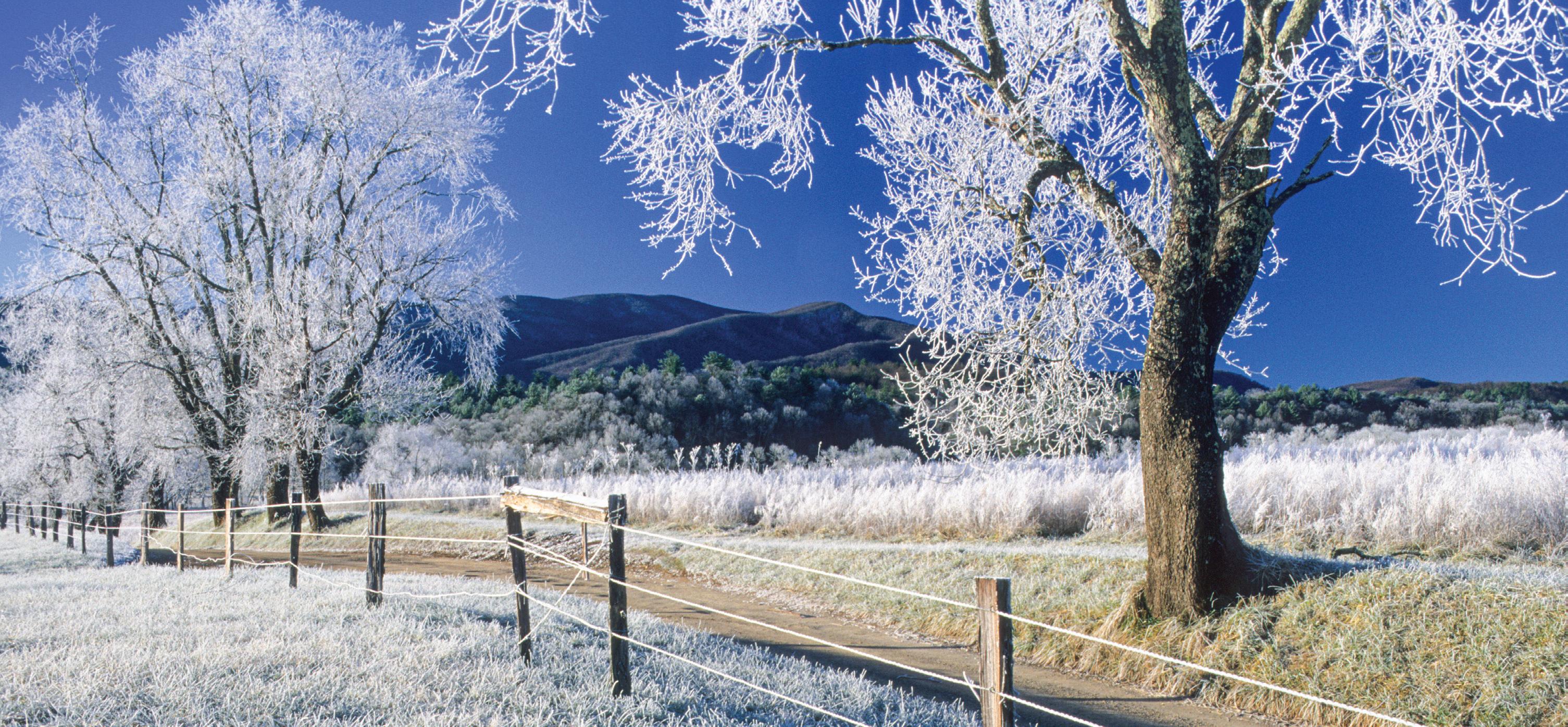
During winter, it can be easier to see wildlife because deciduous trees have lost their leaves. Use a viewfinder or binoculars to get a good look at winter-active animals like this bobcat without disturbing or harassing them. Image by Bill Lea.
SMOKIES GUIDE
Smokies Guide is produced four times per year by Great Smoky Mountains Association and Great Smoky Mountains National Park. nps.gov/grsm SmokiesInformation.org
Publication dates: Spring: mid-March Summer: early June Autumn: mid-Sept. Winter: mid-Dec.
Senior Editor Frances Figart Managing Editor Aaron Searcy
For rent The Appalachian Clubhouse and Spence Cabin at Elkmont can be rented for daytime events starting April 2. Book reservations at recreation.gov.
Writers Valerie Polk Sarah Shiver
Design Assistants Lisa Horstman Emma DuFort
Lead Designer Karen Key
NPS Coordinator Stephanie Kyriazis
Smokies Guide Winter 2020–21 • 2
Firewood To prevent the spread of destructive insect pests, the NPS has banned outside firewood from entering the park unless it is USDA- or state-certified heat-treated wood. Campers may gather dead and down wood in the park for campfires. Certified wood may be purchased in and around the park. Bicycling Most park roads are too narrow and heavily traveled for safe or enjoyable bicycling. Bicycles are permitted on roads but prohibited on trails except Gatlinburg, Oconaluftee River, and lower Deep Creek/Indian Creek trails. Helmets are required by law for persons age 16 and under. However, helmets are strongly recommended for all bicyclists. Pets in the park Pets are allowed in front-country campgrounds and beside roads as long as they are restrained at all times. Pets are not allowed on park trails, except for the Gatlinburg and Oconaluftee River trails. Dogs on these trails must be leashed. Special events Postponed until 2021 Festival of Christmas Past: Sugarlands Visitor Center (December) Holiday Homecoming: Oconaluftee Visitor Center (December) Picnic areas Picnic areas are open year-round at Cades Cove, Deep Creek, Greenbrier, and Metcalf Bottoms. All others are expected to open in spring. Picnic areas have a table and raised grill (charcoal fires only). See map on page 12 for locations. Picnic pavilions may be reserved for $12.50–$60 at recreation.gov.
Planning Committee Katherine Corrigan Paul Super Stephanie Sutton
© 2020 Great Smoky Mountains Association P.O. Box 130 Gatlinburg, TN 37738
E Printed on recycled paper
Other services There are no gas stations, showers, or restaurants in the national park. Park weather • Spring - March has the most changeable weather; snow can fall on any day,
especially at the higher elevations. Backpackers are often caught off guard when a sunny day in the 70s°F is followed by a wet, bitterly cold one. By mid- to late April, the weather is milder.
• Summer - By mid-June, heat, haze, and humidity are the norm. Most precipitation occurs as afterObserve wildlife rules... noon thunderbut with people! showers.
SOCIAL DISTANCING
• Autumn - In mid-September, a pattern of warm, sunny days and crisp, clear nights often begins. However, cool, rainy days also occur. Snow may fall at the higher elevations in November. Wash your hands with soap and water for at least 20 seconds.
If you sneeze or cough, cover your mouth and nose with a tissue.
Stay home when sick.
Avoid touching your face.
Stay 6 feet away from other people.
Still don’t use slower friends as bear bait.
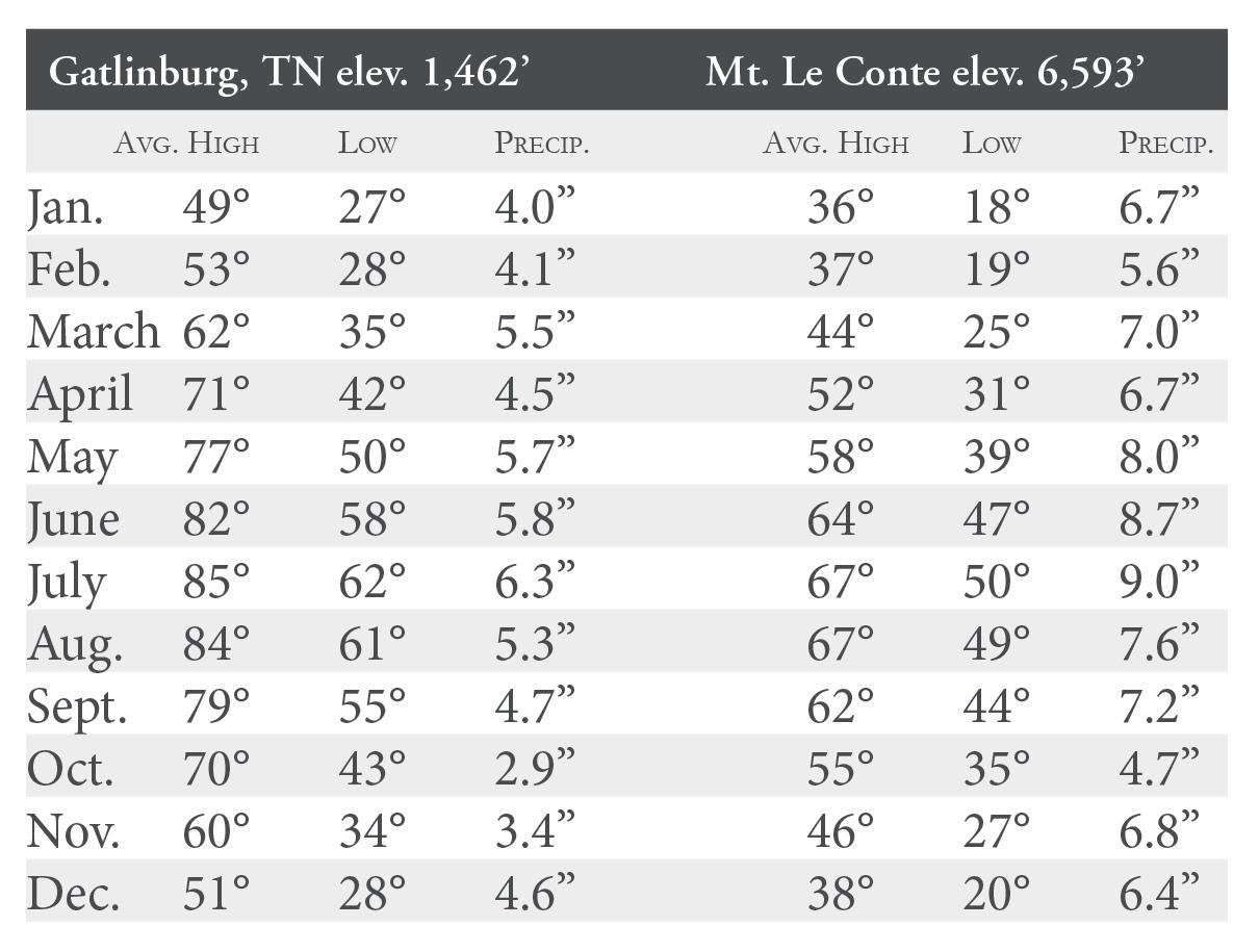
• Winter - Days during this fickle season can be sunny and 65°F or snowy with highs in the 20s. At the low elevations, snows of 1" or more These temperature and precipitation averages are based on data for the last 20 years. Temperatures are in degrees Fahrenheit. An average of over 84" (7 feet) of precipitation falls on the higher elevations of the Smokies. On Mt. Le Conte, an average of 82.8" of snow falls per year.
occur three to five times per year. At Newfound Gap, 69" fall on average. Lows of -20°F are possible at the higher elevations. Fishing Fishing is permitted year-round in the park, and a Tennessee or North Carolina fishing license is required. Either state license is valid throughout the park, and no trout stamp is required. Fishing with bait is prohibited in the park. A special permit is required for the Qualla Boundary and Gatlinburg. Licenses are available in nearby towns. A free fishing map with a complete list of all park fishing regulations is available at visitor centers. Camping in the backcountry Winter camping can be an exciting adventure for persons properly equipped and informed. To facilitate this activity, the National Park Service maintains more than 800 miles of trails and more than 100 backcountry campsites and shelters throughout the park. One of the greatest challenges for backcountry campers is deciding where to go. Here are some tools to help. 1. Get the map. Go online to view the park’s official trail map (nps.gov/grsm/ planyourvisit/maps.htm), which shows all park trails, campsites, and shelters. Park rules and regulations are also listed here. If you wish, you can purchase the printed version of the trail map for $1 by stopping at any park visitor center, calling 865.436.7318, ext. 226, or shopping online at SmokiesInformation.org. 2. Plan your trip. Call or stop by the park’s backcountry office, which is open daily from 8 a.m. to 5 p.m., for trip planning help. The office is located in Sugarlands Visitor Center, two miles south of Gatlinburg on U.S. 441. 865.436.1297. 3. Get a permit. Make your reservation and obtain your permit through the backcountry office at Sugarlands Visitor Center (by phone or in person) or online at smokiespermits.nps.gov. Reservations and permits are required for all overnight stays in the
Smokies Guide Winter 2020–21 • 3
backcountry. The cost is $4 per person per night. Reservations may be made up to 30 days in advance. Winter hikers should be especially aware of quickly changing conditions and the danger of hypothermia—the lowering of body temperature. Always carry an ample supply of food, water, and reliable rain gear. Layer clothing that provides warmth when wet (not cotton). Be prepared for sudden weather changes, especially at the higher elevations, including rain, cold, and wind. Stay dry, and know your limitations. See page 8 for more trip essentials.
Driving distances and estimated times Cherokee, NC to: Gatlinburg: 34 miles (1 hour) Cades Cove: 58 miles (2 hours) Newfound Gap: 18 miles (½ hour) Clingmans Dome: 25 miles (¾ hour) Cataloochee: 39 miles (1½ hours) Deep Creek: 14 miles (½ hour) Gatlinburg, TN to: Cherokee: 34 miles (1 hour) Cades Cove: 27 miles (1 hour) Newfound Gap: 16 miles (½ hour) Clingmans Dome: 23 miles (¾ hour) Cataloochee: 65 miles (2½ hours) Greenbrier Cove: 6 miles (¼ hour) Deep Creek: 48 miles (1½ hours) Townsend, TN to: Cades Cove: 9 miles (¼ hour) Newfound Gap: 34 miles (1¼ hours) Gatlinburg: 22 miles (¾ hour) Cherokee: 52 miles (1½ hours) Look Rock: 18 miles (½ hour) Cataloochee: 87 miles (3 hours)
State of the Park 2020 A I R Q U A LI T Y Good news Ozone pollution, acid deposition, particulate matter, visibility, and regional haze levels in the park have all improved dramatically since the late 1990s thanks to cleaner power plants and motor vehicles. Bad news Because of sulfur and nitrogen air pollution, park rainfall is five times more acidic than natural rainfall, causing some park streams to become too acidic to meet Clean Water Act standards. On a few days each year, ground-level ozone pollution and particulate matter can make air in the park unhealthy to breathe. This is also impacting streams, soils, vegetation, and ecosystems.
H I STO R I C PR E S E R V ATI O N
PL A N T LI F E
Good news Work continued on Elkmont area cabins and the Noah “Bud” Ogle Cabin, including repairs to the damaged chimney and addressing drainage around the foundation. Resource management and science staff have developed an interdisciplinary program for preserving historic cemeteries and commenced work at test sites.
Good news Park forestry staff continued to save trees by treating 30,000 hemlocks and 384 ash trees for non-native hemlock woolly adelgid and emerald ash borer. Preserving these tree species greatly enhances ecological integrity, natural scenery, and visitor safety in high-use areas.
Bad news The park’s historic structures and rock walls are being permanently damaged by vandals carving or writing their names on them. If you witness vandalism, please call 865.436.1230 to report it.
Bad news Destructive non-native gypsy moths were caught in three of the 60 traps deployed by park forestry staff. Some uninformed park campers continue to bring firewood that is not heat-treated and thus likely to introduce new forest insects and diseases to the park.
W I LD LI F E
V I S I TO R E X PE R I E N CE
STR E A M LI F E
Good news A collaborative project to accurately estimate elk populations is going well and now entering its second year. Wildlife staff are working with bear biologists throughout the Southeast to educate people on how to live responsibly with black bears. Check it out at bearwise.org.
Good news Deep Creek received a muchneeded pavement preservation treatment, improving access to the campground, picnic area, and trailheads. The park’s Trails Forever crew completed a two-year trail rehabilitation of the popular Trillium Gap Trail. The experience is now safer for visitors and more sustainable for future users!
Good news Stream acidity in mid- to low-elevation streams has improved moderately thanks to reductions in acid rain. Greenside Darters introduced into lower Abrams Creek are thriving and should help native mussel reproduction over time. Aquatic insect populations, which are good indicators of stream health, generally remained diverse and abundant.
Bad news Bears continued to travel outside the park into areas with unsecured garbage and human-related food. Park bat populations remain low after being decimated by whitenose syndrome. Although elk populations continue to expand, several adult elk have died this year as a result of vehicle collisions. This should serve as a reminder to obey park speed limits and keep alert for wildlife along roadways at all times.
Bad news Increasing congestion at some of the most popular destinations created challenges for visitors including long wait times for restrooms, lack of available parking, and heavy traffic. To help prevent congestion, visitors are reminded to consider less-traveled trails or roads and to plan their visits during mid-week and early mornings.
Smokies Guide Winter 2020–21 • 4
Bad news Twelve park streams (41 miles) remain officially listed as impaired by acid deposition. Water quality improvements are occurring very slowly in high-elevation streams because soils there are saturated with decades of acids from airborne pollutants. Research indicates it will take more than 60 years for most of the park’s sensitive streams to recover.
Words with a Ranger continued from page 1
folks prior to arrival to the park, working with park staff who help hikers make decisions about which trails to take, and involving the maintenance program to reduce areas that may cause injuries on trails. I would encourage visitors to know their ability level and have realistic goals for their activities in the park. Always carry the essentials—water and other necessities—when out on the trail. (See pages 8 and 9.) On paper, my job is behind a desk, but I also meet with partners and other EMS and search-and-rescue agencies in the area to see how we can work together toward a cohesive emergency program. I’m still a law enforcement officer, and I respond to law enforcement and EMS calls as well. Every day is different in my job, and I enjoy the variety. My interest in this field began when I was 17 years old. I took an EMS class at Cataloochee Ski Resort in Maggie Valley and became a ski patroller. The first day I walked into that room, I realized that I had found my group of people. I earned a bachelor’s degree in Conservation Science with a specialization in Wilderness Risk Management and then a master’s degree in Public Administration. My first introduction to PSAR was through internships at Zion and Yosemite and again while working with the National Park Service in Alaska. When I moved to Yellowstone, I had the opportunity to join the Emergency Services program in essentially the same role that I have now at the Smokies. Great Smoky Mountains National Park has been very receptive to PSAR and has provided a huge support network. I’m currently working with volunteer Jeff Wadley to assess the park’s incident data from the last five years and determine what the biggest issues are. I’m incredibly grateful to be working for Chief Ranger Lisa Hendy, who is one of the country’s leaders in PSAR. It has been a great learning opportunity for me, and I’m excited to continue building the PSAR program in the Smokies.
PARK NEWS
Great Smoky Mountains National Park news briefs
The Obscure Tale of the Appalachian Cottontail What’s that fluffy animal with long ears hopping across Clingmans Dome? Is it the common eastern cottontail? Or could it be the rare Appalachian cottontail? The Appalachian cottontail (Sylvilagus obscurus) is a charismatic high-elevation species of rabbit thought to be restricted to the Appalachian Mountains south of New York. As the scientific name suggests, it is not easy to see and is hard to distinguish from its cousin, the very similar eastern cottontail. Corinne Diggins can tell the two species apart by studying their skeletons and DNA. Using trapping, telemetry, and counting pellet piles to determine habitat preferences, she and two other researchers recently learned more about the Appalachian cottontail in a study sponsored by the North Carolina Wildlife Resources Commission and hosted in part by Great Smoky Mountains National Park. “There was relatively little data on this species in the southern Appalachian Mountains prior to our study,” said Diggins, a research scientist with the Department of Fish and Wildlife Conservation at Virginia Tech in Blacksburg. “In higher elevations, the rabbits selectively used heath balds and spruce-fir forest. In lower elevations, they selectively used habitats with significant pine and hemlock. Overall, we found them at a wider range of elevations than we had previously thought.”
With their new data, the researchers can begin to make better recommendations for these rabbits’ continued management and conservation. Future study will explore the Appalachian cottontail (Sylvilagus interactions obscurus). Image by Edward Pivorun. between the two species, including differences in habitat use and rates of hybridization. “Because of the difficulties identifying this species in the field, we were not even certain a population of Appalachian cottontails remained in the Smokies,” said Paul E. Super, science coordinator at the park’s Appalachian Highlands Science Learning Center. “This study not only confirms these rabbits remain in the park but also gives us a better understanding of what they need to continue to thrive here.”
SmokiEEEs @ Home Refreshes Online Education Resource Winter brings lots of changes to the Smokies. But this season, transformation won’t be limited to the park itself. The SmokiEEEs @ Home website, smokieees.org, is getting revamped to better facilitate at-home learning! SmokiEEEs @ Home was created in response to the growing need for accessible educational materials for students learning from home during pandemic-related school closures this past spring. Smokies Guide Winter 2020–21 • 5
One of the primary goals of the update is to make the wealth of content generated since then easier to find. Existing material will be reorganized, and searches will be streamlined. “The updated site will have prompts that will allow someone to search by grade level, subject matter, type of activity, and/or topic,” said Education Branch Coordinator Susan Sachs. This will make the site more user-friendly for educators, parents, and students alike. You can also expect to see new material on the updated site. “We will be posting new videos and activities that go along with the park’s virtual field trip offerings,” said Sachs. “This will help an educator who is looking for methods and ideas of how to incorporate outdoor learning on a school campus or for kids learning from home.” The updated website is expected to be available this winter. The park will continue using SmokiEEEs @ Home to deliver lots of educational materials to assist those learning from home.
To Knoxville
Be Aware of Closures
To I-40
Cosby
Exit 443
Hartford
CHEROKEE NATIONAL FOREST
Exit 447
Park View
441
R
n
R
NN
un t ai Mo
Rich
a il
Chimney Tops Chimney Tops
Trail
i
an
ch
ala
Fo o
Charlies Bunion
ION N AT
Newfound Gap
Trail
Oconaluftee Valley Overlook
Tr
Chasteen Creek Falls
rk
Fo
Kan
at
i
l ra i
il
Twentymile Cascade
Fontana Dam
Fontana
La
Lake
vie
wD
Ap p
al a
Swain County Visitor Center
28
©GSMA2020
e
ek
Bi g
Parkw ay
Maggie Valley
Deep Creek
Cherokee Museum
Q UA L L A B O U N DA RY (Eastern Band of Cherokee Indians land)
Picnic Areas Camping
Great Smoky Mountains National Park occupies the traditional lands of the Cherokee (ᏣᎳᎩ, Tsalagi), now the Eastern Band of Cherokee Indians, the Cherokee Nation, and the United Keetoowah Band of the Cherokee.
SYLVA 28
WAYNESVILLE
Major Roads
23 74
143
Dellwood
Soco Gap
441
74
NANTAHALA
NATIONAL
FOREST
To Asheville
19 Oconaluftee River Trail
Trail
Santeetlah Lake
129
g e R id
19
n
JOYCE KILMER - SLICKROCK WILDERNESS AREA
Blu
276
Heintooga Ridge Rd closed for winter
441
23
Paved Roads Gravel Roads Trails Closed Roads Great Mountain Views
B w ar k id ge P lue R
ch
Co ve Ro Cre ad ek
Major Hwys
r
BRYSON CITY
CA
H RT
ke
Juney Whank Falls Trail
CHEROKEE
ia
NO
Cre
Juney Whank Falls
Goldmine Loop Trail
Twentymile FONTANA VILLAGE
Indian Creek Falls Tom Branch Falls
Balsam Mountain
ad Mingo Falls
441
eT
Tw
m enty
Mingus
Mountain Farm Museum Loop Trail
Boogerman Loop Trail
H
Co ve
Trail Hazel Creek Trail
nd Bot ou a/R og o t in He
Smokemont Loop Trail
Oconaluftee Mill Visitor Center
at visitor centers, Cades Cove and Smokemont campgrounds, Deep Creek and Greenbrier picnic areas, and Newfound Gap. Vault toilets are also available at Rainbow Falls and Abrams Falls trailheads.
RK
Exit 20
Ro
Deep
Restrooms are available
Twentymile Loop Trail Wolf Ridge Trail
Clingmans Dome Rd closed 11/30/20–3/31/21
Andrews Bald
Bone Valley Trail
AL
Smokemont
il
PA
Cataloochee PISGAH Valley Overlook NATIONAL FOREST
Cataloochee
Straight Fork Rd closed for winter
Kephart Prong Trail
Clingmans Dome
Appalachia n
Tr a
l e s) hic ve
(
r to mo
ad
Mount Guyot
R tooga idge Road ein
TE
Alum Cave Bluffs
M O U N TA I N S
Big Creek
tom Rd.
o dt
Ro
Lake Cheoah NA
il ra
se clo
ch
Deals Gap
I OL
SMOKY
Fern Branch Falls
Alum Cave Trail
il Tra
n r so
n B ra
Calderwood Lake
E
re sC ke
Cades Cove
129
SE
p Trail
ek T
Thunderhead Mountain
Pa
ES
Ja
b er Ga
Mount Le Conte
Rainbow Falls
Lit tle
cu m
re
r ve
d
il Tra lls
G R E AT
Chilhowee
CHEROKEE NATIONAL FOREST
Cu
Carlos Campbell Overlook
Middle Prong Trail
m sF a
Cades Cove Visitor Center
Hiking Trails Hiking trails are open in winter. However, some trailheads will be inaccessible to motor vehicles because of seasonal road closures. For more information, call 865.436.1200 (road updates and general information), 865.436.1230 (dispatch), or 865.436.1297 (Backcountry Office). You can also follow road status updates at SmokysRoadsNPS on Twitter.
GSM Institute at Tremont Lynn Camp Prong Cascades
Tri lli u bo Tram Gap il Tra w F a ll il s
Ri
tR
Ab ra
Abrams Falls
Abrams Creek
Little
Elkmont
on
Schoolhouse Gap Trail
l
Maloney Point
Ramsey Cascades
Mouse Creek Falls
Porters Flat
Grotto Falls
Road
Trail
Meigs Falls
Sugarlands Visitor Center
Po r t e r s C
op Trai ut T stn Ch e
Fighting Creek Trail
Laurel Falls Laurel Falls r Rive
Tre m
Look Rock Tower
ek Trail Cre
s Trail ade asc Ramsey C
Noah ‘Bud’ Ogle Place
40
Lo w Tra Gap il
Red light #8
in Ra
o
Little Greenbrier School
73
Heritage Center
Cataract Falls
Little Brier Gap Trail
321
Townsend ad
Mount Cammerer Trail
NA
es M ounta i n
Ap p
t hi
Townsend Visitors Center
Rich Mountain Rd closed for winter
Hen Wallow Falls Gab
GATLINBURG
Wears Valley
Metcalf Bottoms
ll s
Pa
Foothills Parkway
ek Tra il
To Chattanooga
73
321
Roaring Fork Motor Nature Trail closed for winter
Big
Gatlinburg Welcome Center National Park Information Center
Greenbrier
ay Walland s Park w l l i h F o ot
ay rk w
Pittman Center
N OR TH C AROL I
Mount Cammerer
Tr
321
Cosby
TENNESSEE
Exit 451
32
PIGEON FORGE
129 411
Road Closures Clingmans Dome Road Forge Creek Road (in Cades Cove) Greenbrier Road section closed to Porters Flat due to repairs Heintooga/Round Bottom Road Heintooga Ridge Road Little Greenbrier Road (to Little Greenbrier Schoolhouse) Parson Branch Road (in Cades Cove) closed due to hazardous trees Rich Mountain Road (in Cades Cove) Roaring Fork Motor Nature Trail Straight Fork Road
Other Facility Closures Riding stables, grist mills, and LeConte Lodge are closed for the season.
th
To Newport
ay
411
321
Snow Seekers For people seeking a place to play in the snow, Clingmans Dome Road (closed in winter) is popular with walkers and cross-country skiers. Walking on seasonally closed roads is permitted unless snow plowing or construction work is underway. There are no areas suitable for sledding in the park; snow-tubing slopes may be available locally.
o Fo
kw Par ills
416
129
321
M
321
32
MARYVILLE
any secondary and higher-elevation park roads are closed to motor vehicles in winter. Upper Tremont Road (beyond the institute) may close for an extended period after winter storms. All park roads, including Newfound Gap, Cataloochee, and Cades Cove, are subject to extended closures due to snow, wind, and rain events.
SEVIERVILLE
ay
Winter-Safe Boot Camp W
inter is a great time to explore Great Smoky Mountains National Park, but the season also brings unpredictable and sometimes dangerous conditions. “You might start out your hike on a clear, blue-sky day and end up contending with cold wind, rain, sleet, or snow,” said Backcountry Management Specialist Christine Hoyer. “Quality rain gear and appropriate warm layers are a must—and not just wearing them but carrying extras with you, too.” After years of experience, Hoyer has arrived at a golden rule for staying safe in the backcountry: “I pack the same essentials no matter what. What you carry and what kinds of conditions you prepare for has nothing to do with how far you plan to walk.” Once ice forms on some shaded sections of popular trails in the higher elevations, it remains throughout the winter. Any number of factors can keep you out on a hike longer than you expected—the slower pace due to cold or snow, a storm, trail obstacles, and in the worst case, an injury. “The best thing you can do is have a solid plan and the willingness to adjust your plan if you need to,” said Hoyer. “Take it slow—think before you act.”
WINTER HIKING ESSENTIALS • Water, a water filter, tablets, or the ability to boil water • Food, including plenty of snacks • Extra layers (base layer, jacket, socks) for changing conditions • Sun protection with sunscreen, sunglasses, and/or a hat—even in winter • Rain gear and pack cover to keep what you are carrying dry (ziplocs inside your pack can do this too) • Traction support—Hiking poles or microspikes • Navigation—Map and compass and the knowledge of how to use them Image by Bruce Day
• Shelter in the form of a tent or tarp • Flashlight or headlamp and batteries • Fire starter with a lighter, strike stick, and something to light • Knife or multi-tool •E mergency whistle • First aid kit with all the essentials to care for common accidents • Permit for camping overnight
Smokies Guide Winter 2020–21 • 8
Setting Out for the Mountains Safely It is your responsibility to be safe and to know and obey park rules. You can find information and rules at visitor centers, trailhead bulletin boards, and the park website at nps.gov/grsm.
#RecreateResponsibly This winter it remains important to recreate responsibly in Great Smoky Mountains National Park. Before you head out, familiarize yourself with these simple reminders from the #RecreateResponsibly campaign to stay safe and help create an inclusive outdoors for everyone in the Smokies.
TRAIL HAZARDS: • Poison ivy and brambles
• Lightning
• Slippery logs, rocks, and leaves
• High winds
• Ice on wooden structures, rocks, and shady sections of trail
• Hypothermia
• Water crossings, which are particularly dangerous in cold weather (stay dry and closely supervise children around water)
• Dead or downed trees
• Rapid changes in weather
• Wildlife including black bears and elk
IN AN EMERGENCY: • Never hike alone or split up from your party. Remain on established trails. • If you can acquire a signal, call emergency dispatch (865.436.9171) or dial 911. • R emain with any injured party until help arrives. Remain calm and focus on actions that will help speed the rescue and ensure the comfort and survival of the victim. • U se what basic first-aid techniques you know, but do not attempt invasive intervention unless you are medically trained. • I ssue a series of three spaced blasts on an emergency whistle every few minutes to alert the rescue crew of your location. • If you are in an open area visible from the air, display brightly colored clothing or gear. Plan ahead: Inform the NPS backcountry office of your itinerary before you hit the trail so response crews will know where to begin looking in the event of an emergency. Let the NPS help you plan a hike and prepare for what you may experience along the way. Backcountry Office: 865.436.1297, 9 a.m.–5 p.m. Graphic courtesy of recreateresponsibly.org Smokies Guide Winter 2020–21 • 9
IF YOU LOVE THE SMOKIES Great Smoky Mountains National Park depends on four primary nonprofit partners as well as 2,800 park volunteers to help its staff meet the needs of 12.5 million visitors and manage 522,000 acres of resources. Great Smoky Mountains Association Since 1953, the nonprofit Great Smoky Mountains Association has supported the educational, scientific, and historical preservation efforts of the park by operating the park’s official bookstores, publishing books and other media about the park’s natural and cultural resources, and supporting park programs. Over the years, GSMA has contributed more than $46 million to assist with living history demonstrations, save hemlock trees, fund natural resource education internships, construct visitor centers and the Collections Preservation Center, and much more. Association members receive a number of benefits to keep them informed about special events in the park and issues affecting the Smokies: • Subscription to the biannual full-color magazine Smokies Life • Digital access to this award-winning park newspaper and Smokies LIVE e-newsletter • 15–20% discount on books, music, gifts, and products at park visitor centers and at GSMA’s web store • 10% (or more) discount at 500+ additional nonprofit public lands partner stores • Access to member-exclusive group hikes, backpacking excursions, and educational sessions • Invitation to GSMA’s Members Weekend Join today by visiting SmokiesInformation. org or call us at 888.898.9102, ext. 257.
Join the park’s partners in helping to protect this place for ourselves and future generations
Friends of the Smokies Friends of the Smokies assists the National Park Service in its mission to preserve and protect Great Smoky Mountains National Park by raising funds and public awareness and providing volunteers for needed projects. Since it was founded in 1993, supporters of Friends have contributed more than $70 million to meet park needs. Examples of programs and projects include: • Rehabilitation of the most impacted trails through Trails Forever • Forest conservation and wildlife management • Real-time webcams and air quality monitoring • Facility improvements and visitor amenities • Historic structures rehabilitation • Cultural experiences and special events • Search and rescue program support and equipment • K–12 educational programs Programs like Parks as Classrooms, which serves approximately 20,000 students every year, provide educational experiences that help foster a love for nature and inform the next generation of park supporters. A new digital learning space at Smokieees.org invites students to explore nature-related activities, be entertained through music, art, and stories, and escape through observation of the natural world. Friends’ commitment to preservation includes support for restoring and maintaining historic log homes, barns, outbuildings, churches, schools, and gristmills. Become a Friend by visiting FriendsOfTheSmokies.org. For information about memberships and planned giving, email info@friendsofthesmokies.org or call 800.845.5665.
Discover Life in America The Smokies have long been renowned for their rich variety of life. Knowing what creatures reside here helps the National Park Service better protect the Smokies against threats like air pollution, wildfire, habitat fragmentation, invasive species, and climate change. Discover Life in America is a nonprofit partner that was launched in 1998 to manage the All Taxa Biodiversity Inventory (ATBI), an effort to identify and learn about every variety of plant and animal in the park. The organization works with leading biologists from around the globe to conduct this massive inventory. Volunteers and interns become ‘citizen scientists’ who help with DLiA’s work. These participants get an insider’s look at the park, as well as firsthand knowledge of biology, field science, and laboratory practices. Funding comes from donations by individuals and institutions. To date, DLiA has helped add more than 10,000 species to the inventory of life in the park, including more than 1,000 species completely new to science! Today there are more than 21,000 different kinds of organisms known to the park with new discoveries happening
every day. You can support DLiA by purchasing the Smokies Species-a-Day perpetual calendar. Learn more at DLiA. org or by calling 865.430.4757. Tremont Born out of a need for residential education programs in the park, Great Smoky Mountains Institute at Tremont has offered student and adult programs that promote a connection to nature for more than 50 years. Up to 6,000 students and adults annually attend workshops, camps, and school programs at the institute that are designed to promote curiosity and inspire learning. Adult workshops include hiking, backpacking, community science, professional and teacher development, photography, and the Southern A ppalachian Naturalist Certification program. Summer camps provide youth and their families opportunities to spend six to 11 days exploring the national park and its wonders. Fees include meals, lodging, and most equipment. Call 865.448.6709 or visit GSMIT. org for program dates and information and to learn how you can support life-changing learning experiences in the Smokies!
GSMA MEMBERSHIPS Get Rooted in the Smokies!
SIGN ME UP!
GSMA memberships are available in both individual- and family-level packages.
___________________________________
q Acorn (youth) $15 q Buckeye $35/ $50 family q Chestnut $100/ $125 family q Dogwood $200/ $300 family q Hemlock (lifetime) $1,000/ $1500 family q Lookout League Business Memberships
Address ____________________________
$250–$1,000
Smokies Guide Winter 2020–21 • 10
Name(s) ____________________________
___________________________________ Email (for e-newsletter) ______________
___________________________________ Phone # _______________________________ Please include your check with this form. Mail to: GSMA, P.O. Box 130, Gatlinburg, TN 37738
BIRDS
Some birds keep warm by growing a lot more feathers. They also shiver all winter long. Shivering burns fat and produces heat.
BATS
Some bats migrate south for the winter, while others hibernate in caves. In hibernation, their body temperatures drop to about the same air temperature as the cave, and their heart rates and breathing slow.
BEARS
RHODODENDRON
This is one of the most common shrubs in the park. Its long, thick leaves curl up like cigars in cold weather. This helps the plant conserve moisture.
Illustrations by Lisa Horstman Smokies Guide Winter 2020–21 • 11
this pag r o e ol
!
C
About half the bears living in the Smokies make their winter dens in hollow trees, sleeping most of the time. Cubs born in wintertime emerge from their dens in the spring, old enough to climb trees and explore the forest.
Here are a few ways plants and animals survive winter in the Great Smoky Mountains.
VISITOR INFORMATION
For more information, go to nps.gov/grsm
Primary Alt. Rt. Secondary Alt. Rt.
Heintooga/ Round Bottom Road
es)
hicl
ve otor om ed t s o l (c
SWAIN COUNTY VISITOR CENTER
Š
Information General park info: 865.436.1200 • nps.gov/grsm Backcountry information: 865.436.1297 smokiespermits.nps.gov To order maps and guides: 865.436.7318, ext. 226 SmokiesInformation.org
Emergencies For emergencies after hours: Park Headquarters 865.436.9171 Cherokee Police 828.497.4131 Gatlinburg Police 865.436.5181
Hospitals Le Conte/Sevier County 865.446.7000 Middle Creek Rd., Sevierville, TN Blount Memorial 865.983.7211 U.S. 321, Maryville, TN
Haywood County 828.456.7311 Waynesville, NC Swain County 828.488.2155 Bryson City, NC
All-access Restrooms at park visitor centers in Cades Cove, Oconaluftee, and Sugarlands are fully accessible. Sugarlands Valley all-access nature trail is on Newfound Gap Road just south of Sugarlands Visitor Center.
Avoid the fine Picking or digging plants is prohibited in the park. Persons feeding wildlife are subject to a $5,000 fine. Pets are only permitted on the Gatlinburg and Oconaluftee River trails, which allow dogs on a leash.