![](https://assets.isu.pub/document-structure/221124224239-e96a3192cd5e5683ea112fac60315c68/v1/6102b74493b65083b40e89d7ee3245fd.jpeg)
![](https://assets.isu.pub/document-structure/221124224239-e96a3192cd5e5683ea112fac60315c68/v1/3a9f4d5624c0cd99dd338c8378d6fab7.jpeg)
![](https://assets.isu.pub/document-structure/221124224239-e96a3192cd5e5683ea112fac60315c68/v1/1e4985be963964c6fefc6f222de88205.jpeg)
![](https://assets.isu.pub/document-structure/221124224239-e96a3192cd5e5683ea112fac60315c68/v1/93901379ab179e38cdfaa529c17b97fb.jpeg)
![](https://assets.isu.pub/document-structure/221124224239-e96a3192cd5e5683ea112fac60315c68/v1/a285ef20b7ba3927c29c7d43fb315865.jpeg)
Thesis Design
Toronto Island Redesign Slow Landscapes Landscape Urbanism Regenerative Technologies
Landscape and Culture Fort and Tumli Visual Communication Green Infrastructure reseearch
Thesis 4
Making Intangible Natural Processes Tangible: ReImagining Access into a Decommissioned Quarry Landscape
Group Work
12 20 28 36
40 42 44
Permeating Place
Generational Memories
Under the Humber: Elements of a Metabolic Landscape Spurring Green
Independent and Research Studies
Iqaluit Municipal Cemetery Study Castillo San Marcos Study
GRIT LABS
Deceptive. Blue Ringed Octopus. 2018.
![](https://assets.isu.pub/document-structure/221124224239-e96a3192cd5e5683ea112fac60315c68/v1/58a658f2c2328127111881d17fd19cfa.jpeg)
![](https://assets.isu.pub/document-structure/221124224239-e96a3192cd5e5683ea112fac60315c68/v1/d7a66903ed5062563bed17ec42fa9e2b.jpeg)
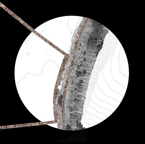
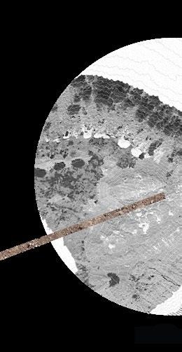
Making Intangible Natural Process Tangible Reimagining Access into a Decommissioned Quarry Landscape
Thesis Studio 2022
Dolime Quarry, Guelph ON Academic, Semester
How can we humanize the extractive landscape?
Within Ontario, there is a requirement for quarried landscapes to be rehabilitated following strict guidelines that typically exclude people from the process. This has created a disconnect in our understanding of these unique spaces and how they are shaped by a stratum of anthropogenic and natural histories.
This project rethinks how we engage with material legacies embedded within the landscape. It seeks to engage the senses within the quarry and bring attention to the novel ecosystems emerging in the aftermath of extraction.
![](https://assets.isu.pub/document-structure/221124224239-e96a3192cd5e5683ea112fac60315c68/v1/b5cbc6cf9a5b89af823b53715cd3d70e.jpeg)
There are over 6000 active extraction sites in Ontario that quarry materials we use daily.
![](https://assets.isu.pub/document-structure/221124224239-e96a3192cd5e5683ea112fac60315c68/v1/72d68e92ea9d624b8106c0cf47ebe191.jpeg)
![](https://assets.isu.pub/document-structure/221124224239-e96a3192cd5e5683ea112fac60315c68/v1/c63eed1733d422a04654618ef4e057a9.jpeg)
![](https://assets.isu.pub/document-structure/221124224239-e96a3192cd5e5683ea112fac60315c68/v1/8108f03a5e11ecaab7d82690faa9c0a7.jpeg)
![](https://assets.isu.pub/document-structure/221124224239-e96a3192cd5e5683ea112fac60315c68/v1/dbca3bd43778e21080bfc8420a4cfb49.jpeg)
![](https://assets.isu.pub/document-structure/221124224239-e96a3192cd5e5683ea112fac60315c68/v1/93740bff1757d6ad4f234b417c8f2367.jpeg)
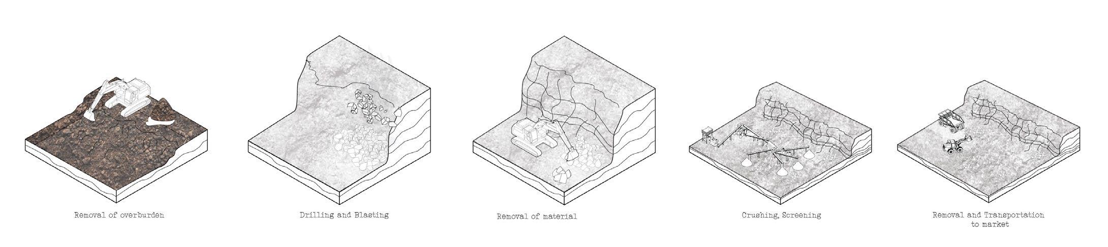
Extraction and restoration processes are replicated across sites regardless of scalability. The period of ‘restoration’, creates a gap during disuse onsite, and invites desires for change by local communities.
![](https://assets.isu.pub/document-structure/221124224239-e96a3192cd5e5683ea112fac60315c68/v1/6f0b83ac964ecd16f767cacff4fd10f4.jpeg)
![](https://assets.isu.pub/document-structure/221124224239-e96a3192cd5e5683ea112fac60315c68/v1/8c757c15eb8d742a12e57bd35ce52d58.jpeg)
![](https://assets.isu.pub/document-structure/221124224239-e96a3192cd5e5683ea112fac60315c68/v1/8d5e1004ce0e8d4ab9e72e6d083f2ec4.jpeg)
![](https://assets.isu.pub/document-structure/221124224239-e96a3192cd5e5683ea112fac60315c68/v1/bf30d44e44e4d4e286c54ea25b853572.jpeg)
![](https://assets.isu.pub/document-structure/221124224239-e96a3192cd5e5683ea112fac60315c68/v1/b576fac29ae8c75c68d013122a1c56ff.jpeg)
The diagram reflects this relationship in the Dolime Quarry as typical natural processes are spatially influenced by the flow of materialduring extraction.
![](https://assets.isu.pub/document-structure/221124224239-e96a3192cd5e5683ea112fac60315c68/v1/90bb54df6572f053c7a3d45f5d14b008.jpeg)
A path is proposed to guide five different sensory-process experiences in the Dolime Quarry connected to its unique character.
![](https://assets.isu.pub/document-structure/221124224239-e96a3192cd5e5683ea112fac60315c68/v1/6e067eee8a29182eedeb6cc061f60cc5.jpeg)
![](https://assets.isu.pub/document-structure/221124224239-e96a3192cd5e5683ea112fac60315c68/v1/54593c520275d0f1e42ac39bdbfc903e.jpeg)
![](https://assets.isu.pub/document-structure/221124224239-e96a3192cd5e5683ea112fac60315c68/v1/8e90015b37ff2cf0f6790c615c0dafa7.jpeg)
![](https://assets.isu.pub/document-structure/221124224239-e96a3192cd5e5683ea112fac60315c68/v1/df6667b0f5e40fa0974304abef39f00e.jpeg)
![](https://assets.isu.pub/document-structure/221124224239-e96a3192cd5e5683ea112fac60315c68/v1/33f54ae87e65d644ec9bad9b7e468fc1.jpeg)
![](https://assets.isu.pub/document-structure/221124224239-e96a3192cd5e5683ea112fac60315c68/v1/f10bce658f15199c14c973b52a680453.jpeg)
![](https://assets.isu.pub/document-structure/221124224239-e96a3192cd5e5683ea112fac60315c68/v1/cc2e0fb925a1a2d90c87035d56a0694c.jpeg)
![](https://assets.isu.pub/document-structure/221124224239-e96a3192cd5e5683ea112fac60315c68/v1/0131e7fde731988a5d49cd66617c4e6d.jpeg)
![](https://assets.isu.pub/document-structure/221124224239-e96a3192cd5e5683ea112fac60315c68/v1/7499031442305245e50531acedf1f04b.jpeg)
![](https://assets.isu.pub/document-structure/221124224239-e96a3192cd5e5683ea112fac60315c68/v1/37d4c4b18847797c5b29b302163b0e6a.jpeg)
![](https://assets.isu.pub/document-structure/221124224239-e96a3192cd5e5683ea112fac60315c68/v1/68e272b82271dc4bc24ca8010f9f9b81.jpeg)
![](https://assets.isu.pub/document-structure/221124224239-e96a3192cd5e5683ea112fac60315c68/v1/9ac810a1b8f3947a034f8d03f9ad3906.jpeg)
![](https://assets.isu.pub/document-structure/221124224239-e96a3192cd5e5683ea112fac60315c68/v1/45006379e1e6724239cdb9ba84db1b7d.jpeg)
![](https://assets.isu.pub/document-structure/221124224239-e96a3192cd5e5683ea112fac60315c68/v1/f331d1b839e6901595e29fc321d9e878.jpeg)
![](https://assets.isu.pub/document-structure/221124224239-e96a3192cd5e5683ea112fac60315c68/v1/2f48bb3dc2f1072ac804cb3af7b13064.jpeg)
![](https://assets.isu.pub/document-structure/221124224239-e96a3192cd5e5683ea112fac60315c68/v1/91d64d0e44682a351633de8c5a57be12.jpeg)
![](https://assets.isu.pub/document-structure/221124224239-e96a3192cd5e5683ea112fac60315c68/v1/f4a49ed26f6f4bf7bffb34bfd000c47b.jpeg)
![](https://assets.isu.pub/document-structure/221124224239-e96a3192cd5e5683ea112fac60315c68/v1/be683bdce8e20c0f676d0f747ff1d456.jpeg)
Permeating Place
Bernardo Velsco Canela & Howard Rosenblat Comprehensive Studio 2021![](https://assets.isu.pub/document-structure/221124224239-e96a3192cd5e5683ea112fac60315c68/v1/391f315b87b707fb00ae2abcc9c92960.jpeg)
Toronto Islands Academic, Semester
Can we design an island where flooding can enhance the experience?
As the climate changes the Toronto Islands are confronted by increasing flooding and erosion. It is estimated that a 100-500 year flood event will submerge most of the islands in the future. The Toronto Islands are tradiationally seen as a refuge for all species during the year.
Permeating Place imagines the Toronto Islands with the ability to ‘breathe’; a space resilient to fluctuating water levels for multi-species healing, migration and placekeeping. Inner harbour edges are softened to create resilient living shorelines, while edges exposed to open waters are hardened to reduce the impact of erosive wave action.
Often seen as limiting or a nuisance, the proposal celebrates seasonal change that affects movement. Human and animal movements will be adapted to the increasing floods through a continuous corridor resilient to irregular climatic events.
Rendered proposal of the future for Permeating Place.
![](https://assets.isu.pub/document-structure/221124224239-e96a3192cd5e5683ea112fac60315c68/v1/7d625185739a56db9b5c1f2954643ae6.jpeg)
![](https://assets.isu.pub/document-structure/221124224239-e96a3192cd5e5683ea112fac60315c68/v1/0937724a315bb3a9fe35871b58b22b98.jpeg)
![](https://assets.isu.pub/document-structure/221124224239-e96a3192cd5e5683ea112fac60315c68/v1/bbf1e591f39c7f456bab2fe9968b5e05.jpeg)
![](https://assets.isu.pub/document-structure/221124224239-e96a3192cd5e5683ea112fac60315c68/v1/72e9510fb3064b4bb3675161517a3a84.jpeg)
![](https://assets.isu.pub/document-structure/221124224239-e96a3192cd5e5683ea112fac60315c68/v1/c35343486ae8f2da2d0fadd5a3c8975b.jpeg)
Analysis of ecological, geological and social histories guided the distinct transformations in the above proposal.
![](https://assets.isu.pub/document-structure/221124224239-e96a3192cd5e5683ea112fac60315c68/v1/ae8a41edeef8e0f6792cdf17cc3e93e0.jpeg)
![](https://assets.isu.pub/document-structure/221124224239-e96a3192cd5e5683ea112fac60315c68/v1/57d8732a03bbe2e803a6e5b6a865c5ce.jpeg)
![](https://assets.isu.pub/document-structure/221124224239-e96a3192cd5e5683ea112fac60315c68/v1/be20730e5cefdbd1a806e34dab0c0226.jpeg)
![](https://assets.isu.pub/document-structure/221124224239-e96a3192cd5e5683ea112fac60315c68/v1/5255aae2e252f0ff1223bf74f5717540.jpeg)
Above is an independent study of the edge condition of Olympic Island in the Toronto Islands showing a submergence of 0.4m to 1.0m. The open space primarily used for activity lacks ecology for resilience to spontaneous weather events.
![](https://assets.isu.pub/document-structure/221124224239-e96a3192cd5e5683ea112fac60315c68/v1/f163cc5fd1b9c48bd5999dd747fad5b1.jpeg)
![](https://assets.isu.pub/document-structure/221124224239-e96a3192cd5e5683ea112fac60315c68/v1/e61a603a29ee6043a05db060ddb8d4bb.jpeg)
![](https://assets.isu.pub/document-structure/221124224239-e96a3192cd5e5683ea112fac60315c68/v1/c9f5f7b8f0405092a7c1cdfeb139ea25.jpeg)
![](https://assets.isu.pub/document-structure/221124224239-e96a3192cd5e5683ea112fac60315c68/v1/767f1ad450c970d50b12901d0bb6505c.jpeg)
![](https://assets.isu.pub/document-structure/221124224239-e96a3192cd5e5683ea112fac60315c68/v1/4d87774d29702125f296684e7424fe63.jpeg)
![](https://assets.isu.pub/document-structure/221124224239-e96a3192cd5e5683ea112fac60315c68/v1/8d6a5bdd853212544a70238a11966bd5.jpeg)
Hard edge conditions are imagined as formalized public space where visitors are invited to engage with the water.
![](https://assets.isu.pub/document-structure/221124224239-e96a3192cd5e5683ea112fac60315c68/v1/03fd68109f8bf4af78ca1353b3fac686.jpeg)
![](https://assets.isu.pub/document-structure/221124224239-e96a3192cd5e5683ea112fac60315c68/v1/1bba10f0d89694802acf6da617318c08.jpeg)
A combination of hard and soft strategies reimagine edge conditions to serve socio-ecological access to water, resilient to fluctuating water levels .
![](https://assets.isu.pub/document-structure/221124224239-e96a3192cd5e5683ea112fac60315c68/v1/c4db59c4b08aaa299d4422cb2fa25fe9.jpeg)
![](https://assets.isu.pub/document-structure/221124224239-e96a3192cd5e5683ea112fac60315c68/v1/f3de185f0b7bb020f240631602997cca.jpeg)
Combined strategy of restablishing the foredunes with marram grass and formal boardwalk promotes resilience and mobility.
![](https://assets.isu.pub/document-structure/221124224239-e96a3192cd5e5683ea112fac60315c68/v1/12afd571f03ac43939549dee8a662697.jpeg)
![](https://assets.isu.pub/document-structure/221124224239-e96a3192cd5e5683ea112fac60315c68/v1/413fa2ce5d2a7585f6846eb86c0676ff.jpeg)
Generational Memories
Dagmar Ivanenko & Howard Rosenblat Option Studio 2021
Prince Edward County, ON Academic, Semester
Generational Memories is the re-establishment of relationships with the land by honoring human and non-human relations. The land holds memories, connecting us through time in the past, present, and future. We imagine these memories through the fragmented and hidden materiality of plants, rocks, soils, which are returned to the landscape as an act of reciprocity. Together they from a spatial and temporal journey that celebrates the interstice and embraces the cycles of life in Prince Edward County. Places of pause act as catalysts for healing lost connections, which over generations establish a new continuous corridor in the heart of the county.
![](https://assets.isu.pub/document-structure/221124224239-e96a3192cd5e5683ea112fac60315c68/v1/f3c9465c35bfa67850ffc66ea3183f12.jpeg)
Fragmented Landscapes
![](https://assets.isu.pub/document-structure/221124224239-e96a3192cd5e5683ea112fac60315c68/v1/e2deb13d4d2ffb337c38e6ecae81c524.jpeg)
![](https://assets.isu.pub/document-structure/221124224239-e96a3192cd5e5683ea112fac60315c68/v1/700fcb504ef89adcc8a6dc5739045229.jpeg)
![](https://assets.isu.pub/document-structure/221124224239-e96a3192cd5e5683ea112fac60315c68/v1/f627e62b2948b68dac2c64519bccfa16.jpeg)
![](https://assets.isu.pub/document-structure/221124224239-e96a3192cd5e5683ea112fac60315c68/v1/9b2e958d9a7994e1cd4c9535ab29b1cc.jpeg)
![](https://assets.isu.pub/document-structure/221124224239-e96a3192cd5e5683ea112fac60315c68/v1/fb960888dda9614b035959d4ffc2dcb5.jpeg)
![](https://assets.isu.pub/document-structure/221124224239-e96a3192cd5e5683ea112fac60315c68/v1/9910c1a84d75acd81b7eab888b383d74.jpeg)
![](https://assets.isu.pub/document-structure/221124224239-e96a3192cd5e5683ea112fac60315c68/v1/2cbb5767d4facfcfb5de0a329918a2c5.jpeg)
A continuous corridor is established over time, reconnecting the forest fragments in Prince Edward County. It is created with memories embedded in the lands natural history with discarded fieldstone, and locally sourced seeds.
![](https://assets.isu.pub/document-structure/221124224239-e96a3192cd5e5683ea112fac60315c68/v1/c02c5cf67068f4d30bb2dbfd98ff550f.jpeg)
![](https://assets.isu.pub/document-structure/221124224239-e96a3192cd5e5683ea112fac60315c68/v1/4676d98b645806f0cbbd687578c94cb5.jpeg)
![](https://assets.isu.pub/document-structure/221124224239-e96a3192cd5e5683ea112fac60315c68/v1/7be1cc87d7e442f1c6cadbd926582fc6.jpeg)
Places of pause create a framework for the corridor.
![](https://assets.isu.pub/document-structure/221124224239-e96a3192cd5e5683ea112fac60315c68/v1/13c4b82bd251b5021c86ef64e85bdc1a.jpeg)
Above, a pause point along a fragmented forest patch collects water for plant establishment.
![](https://assets.isu.pub/document-structure/221124224239-e96a3192cd5e5683ea112fac60315c68/v1/46fa7c1c7eb522bf5f8c1a19e9d57d02.jpeg)
![](https://assets.isu.pub/document-structure/221124224239-e96a3192cd5e5683ea112fac60315c68/v1/525be6434ea63381917a6b00250576f7.jpeg)
Through, Between and Along. The proposal navigates public - private property reconnecting
![](https://assets.isu.pub/document-structure/221124224239-e96a3192cd5e5683ea112fac60315c68/v1/3b4c8716419be6048b5c3018bf30f464.jpeg)
![](https://assets.isu.pub/document-structure/221124224239-e96a3192cd5e5683ea112fac60315c68/v1/74b0904aeccc27effad57270566e1efb.jpeg)
reconnecting ecological patches, and the local communities with the landscape.
![](https://assets.isu.pub/document-structure/221124224239-e96a3192cd5e5683ea112fac60315c68/v1/f6ae8af03bbb7433a81118b9694eef52.jpeg)
![](https://assets.isu.pub/document-structure/221124224239-e96a3192cd5e5683ea112fac60315c68/v1/689fa2c6dade40d118757253c891375a.jpeg)
![](https://assets.isu.pub/document-structure/221124224239-e96a3192cd5e5683ea112fac60315c68/v1/d3c73d16d8306d39262c0cbcd4875b6e.jpeg)
Under the Humber Madison Appleby, Stefan Herda, Howard Rosenblat and Juan Bernardo Canela Velasco Urbanism Studio 2020 Toronto, ON Academic, Semester
![](https://assets.isu.pub/document-structure/221124224239-e96a3192cd5e5683ea112fac60315c68/v1/6dffb4c725d58dad7dc899cd44d7ff7c.jpeg)
After millennia of natural forces slowly carving it away, the Humber Bay has been reshaped by urbanization. Massive inflows of construction fill developed an artificial shoreline, oftentimes contaminated. With an ever-growing population, the pressures of urban systems have placed a renewed strain on the landscape.
Under the Humber’s programming integrates notions of waste efficiencies, food distribution and community engagement into a resilient and adaptive lakeshore. This envisioned circular economy realizes the potential of four energy flows: food, waste, water and people into a closed loop system. A series of strategies, the principles of a metabolic landscape, are applied across a gradient of scales: from the district level to the tactical.
![](https://assets.isu.pub/document-structure/221124224239-e96a3192cd5e5683ea112fac60315c68/v1/6dac3d9520cdd6af3a8a891dceab8f88.jpeg)
![](https://assets.isu.pub/document-structure/221124224239-e96a3192cd5e5683ea112fac60315c68/v1/7ef3257e94d443fe420c094d6c4915bc.jpeg)
The transformed, metabolic, Humber Bay with the elements implemented along the shoreline.
![](https://assets.isu.pub/document-structure/221124224239-e96a3192cd5e5683ea112fac60315c68/v1/4f42721c38822f31f884a202fb23a051.jpeg)
![](https://assets.isu.pub/document-structure/221124224239-e96a3192cd5e5683ea112fac60315c68/v1/22a85c45242c602121cfa66ea30dd597.jpeg)
Axonometric northwest and northeast views of a new Humber Bay.
![](https://assets.isu.pub/document-structure/221124224239-e96a3192cd5e5683ea112fac60315c68/v1/61826eb144d3f6140ea7cf86da9832ef.jpeg)
![](https://assets.isu.pub/document-structure/221124224239-e96a3192cd5e5683ea112fac60315c68/v1/e117ac2261db7eafa2a09acb7a36e4d3.jpeg)
![](https://assets.isu.pub/document-structure/221124224239-e96a3192cd5e5683ea112fac60315c68/v1/89dda767d1c6bf22408764339ec7c388.jpeg)
A small contaminated parkette in Liberty Village required a proposal for redevelopment and addressing contamination. The site possesses the legacy of contaminated fill that was used to expand the downtown shoreline for development. An environmental impact assessment revealed Petroleum Hydrocarbons (PHC’s), Polycyclic Aromatic Hydrocarbons (PAH’s), Metallics and Inorganic contamination. Historically, a rail line spur passed through this area, connecting early industrial lands in Toronto.
The Spurring Green proposal harnesses the historic railroad materiality, and the formalized concrete capped walkway and seating with lighting fixtures evoke a railway stop. This formality contrasts flowing mounds of native grasses and perennials that phytostabilize and rhizodegrade contaminants in the soil. From above, people living in the adjacent apartment buildings can observe the contrast of concrete to colourful blooms. The site is an implied continuation of adjacent park space and supports local pollinators along this corridor.
![](https://assets.isu.pub/document-structure/221124224239-e96a3192cd5e5683ea112fac60315c68/v1/7f5569b0212376c11ef1bca2c72f75da.jpeg)
![](https://assets.isu.pub/document-structure/221124224239-e96a3192cd5e5683ea112fac60315c68/v1/8025138ed5b1883e3d414a116e189cb8.jpeg)
Iqaluit Municipal Cemetery Study
LAN1012 Landscape and Culture Studio A1 2020
Iqaluit, Nunavut Academic, Semester
Iqaluit Municipal Cemetery was a project commissioned in 2014, completed by Lees Architect in Iqaluit, Nunavut. Whale bones serve as an iconic symbology for the cemetery with locally sourced materials, to be reflective of the the local indigenous people and the current communities history. Initial proposals, recorded in meeting notes, examined the use of a large cross instead of the notable whale bones. The project was recognized in an honour award by the ASLA in 2018.
This project uses the juxtaposition of crosses in Christian burials vs. indigenous symbologies to highlight a history of assimilation and genocide of indigenous peoples. It seeks to questions the choices made when deciding the course of landscape and the embedded indigenous histories in Canada. The model design allows the flexibility of removing these features for an interactive experience asking users to observe this against an image of the tundra. This project asks:
![](https://assets.isu.pub/document-structure/221124224239-e96a3192cd5e5683ea112fac60315c68/v1/9838c1280854bc8ea6daebc8fa90736d.jpeg)
![](https://assets.isu.pub/document-structure/221124224239-e96a3192cd5e5683ea112fac60315c68/v1/e186ce246a113f40c6f23ebabdc2cce3.jpeg)
How does the shifting symbology impact the view of the landscape and interpretation of the cemetery?
Is this design reflective of existing cultures or does it reflect of an ideal of what it is believed to be?
![](https://assets.isu.pub/document-structure/221124224239-e96a3192cd5e5683ea112fac60315c68/v1/3f3b0dbfdcbeadb2d83d2c27b68ce009.jpeg)
![](https://assets.isu.pub/document-structure/221124224239-e96a3192cd5e5683ea112fac60315c68/v1/8d369d5fbcea403e45535ca0e4bfd7ee.jpeg)
![](https://assets.isu.pub/document-structure/221124224239-e96a3192cd5e5683ea112fac60315c68/v1/91a04b3a29c4688c21bf5dd9d85e6e39.jpeg)
LAN 1022 Visual Communications 2020 San Antonio, Florida Academic, Semester
![](https://assets.isu.pub/document-structure/221124224239-e96a3192cd5e5683ea112fac60315c68/v1/e2c93ba08d7460f72e6f95cad29d4f12.jpeg)
![](https://assets.isu.pub/document-structure/221124224239-e96a3192cd5e5683ea112fac60315c68/v1/de94a576c236f622eb0c39688258a2ab.jpeg)
![](https://assets.isu.pub/document-structure/221124224239-e96a3192cd5e5683ea112fac60315c68/v1/628f24e5f37a0c2daaba338c1914e8c0.jpeg)
Castillo San Marcos is a historic fort located on the coast of St.Augustine, Florida, built of a resilient coquina material by the Spanish 450 year ago. This study imagines the fort as a last beacon of fortification as the landscape begins to flood around it due to climate change. Last minute plantings of mangrove habitats were a final attempt to stave off significant impacts to the landscape. A murky mixture of saline seawater stirs up sediment, and submerges everything, from the built to the natural. The ocean is reclaiming the land.
![](https://assets.isu.pub/document-structure/221124224239-e96a3192cd5e5683ea112fac60315c68/v1/07a30c49d00d2d811955db885fd4eb34.jpeg)
![](https://assets.isu.pub/document-structure/221124224239-e96a3192cd5e5683ea112fac60315c68/v1/4d0a318eb39767046fb75688fa200c92.jpeg)
![](https://assets.isu.pub/document-structure/221124224239-e96a3192cd5e5683ea112fac60315c68/v1/4e6d150451c35deccecfa0cb5dd8bcbc.jpeg)
The fort was 3D modelled in rhino from old construction layouts and 3D printed; the landscape was rendered in foam with a CNC machine from topographic GIS data.
![](https://assets.isu.pub/document-structure/221124224239-e96a3192cd5e5683ea112fac60315c68/v1/41e70df297079f4799fbb63230539669.jpeg)
![](https://assets.isu.pub/document-structure/221124224239-e96a3192cd5e5683ea112fac60315c68/v1/4f5e3f1c2902234234147c3f069bffdd.jpeg)
![](https://assets.isu.pub/document-structure/221124224239-e96a3192cd5e5683ea112fac60315c68/v1/d10c45f0fb41aabf37af20abd12fa571.jpeg)
![](https://assets.isu.pub/document-structure/221124224239-e96a3192cd5e5683ea112fac60315c68/v1/286900241fcc779c5429e99132b13e2f.jpeg)
GRIT LAB Research 2020-2022 Toronto , Ontario Research
GRIT (Green Roof Innovation Testing Laboratory) is located at the University of Toronto, John H Daniels Faculty of Architecture, Landscape and Design.The lab serves as a testing ground for living infrastructure such as green roofs, considered to be ‘green’ technologies. The goal is to better understand the performance for living infrastructure in urban environments to better guide industry and policy.
The research completed with the GRIT looked into the mapping and layout of green roofs across the 25 wards of Toronto, compared against the green roof data that was recorded by the city. It also included end of life studies for existing green roof plots, regular data recordings and maintenance.
![](https://assets.isu.pub/document-structure/221124224239-e96a3192cd5e5683ea112fac60315c68/v1/78021cffe775f971ce69fbf56e56c799.jpeg)
A 10 year anniversary study was conducted in summer 2021 of the GRIT lab’s orignal experimental setup. Sampling methods reflect those completed for an initial report for comparison against original variables.
![](https://assets.isu.pub/document-structure/221124224239-e96a3192cd5e5683ea112fac60315c68/v1/4f2399e4aaf080b8b7a3667cd540b40b.jpeg)
![](https://assets.isu.pub/document-structure/221124224239-e96a3192cd5e5683ea112fac60315c68/v1/5e92cb9fd980be6a862edd916814564d.jpeg)
![](https://assets.isu.pub/document-structure/221124224239-e96a3192cd5e5683ea112fac60315c68/v1/b6f28b89d57c9299c337f0c3661a6b27.jpeg)
![](https://assets.isu.pub/document-structure/221124224239-e96a3192cd5e5683ea112fac60315c68/v1/e66fc06d17ddfa232c66cf187531643c.jpeg)
![](https://assets.isu.pub/document-structure/221124224239-e96a3192cd5e5683ea112fac60315c68/v1/3a106572c646f36e4a6269d87457fcc1.jpeg)
![](https://assets.isu.pub/document-structure/221124224239-e96a3192cd5e5683ea112fac60315c68/v1/79e35a39594c3b47b1ccfbef28e1c725.jpeg)
![](https://assets.isu.pub/document-structure/221124224239-e96a3192cd5e5683ea112fac60315c68/v1/549640fa9e00938ed6f59f8221d81bd2.jpeg)
![](https://assets.isu.pub/document-structure/221124224239-e96a3192cd5e5683ea112fac60315c68/v1/d992400ae75f7f1f2b4f081d3a7eedb1.jpeg)
![](https://assets.isu.pub/document-structure/221124224239-e96a3192cd5e5683ea112fac60315c68/v1/63494dd13523b6d1170c296576202df0.jpeg)
The diagrams are visual representations of Blue-Green-Grey Infrastructure in uban systems, produced for a Blue-Green Infrastructure report that reviews studies on ecosystem services for urban heat island mitgation and stormwater management.
![](https://assets.isu.pub/document-structure/221124224239-e96a3192cd5e5683ea112fac60315c68/v1/8b882b05ed9cbf1c248e25b2c3a94edd.jpeg)
![](https://assets.isu.pub/document-structure/221124224239-e96a3192cd5e5683ea112fac60315c68/v1/0f78013fd50e832e8769e75875fce888.jpeg)
![](https://assets.isu.pub/document-structure/221124224239-e96a3192cd5e5683ea112fac60315c68/v1/8d8a8fce15d368efca8c99751912199b.jpeg)
![](https://assets.isu.pub/document-structure/221124224239-e96a3192cd5e5683ea112fac60315c68/v1/0e555087a09e599e29fd6059d5505af7.jpeg)
![](https://assets.isu.pub/document-structure/221124224239-e96a3192cd5e5683ea112fac60315c68/v1/fb6b37527d18294fdf8444b47805f8c7.jpeg)