8 minute read
Road operation using high-end solutions


Traffic logistics in big cities like the Hungarian capital can prove a headache for planners. Budapest Közút CEO Dr. Kornél Almássy gives us a run down of how his company has been utilising advanced Intelligent Transport Solutions to make the traffic run smoother and reduce carbon emissions in his city.


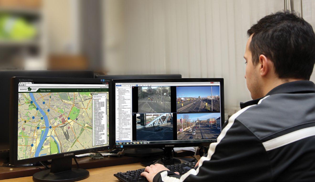
Budapest Közút has grown beyond its original maintenance and operational tasks and has been transformed from the deficit making nationally-owned Budapest Public Maintenance Company into a growing, stable and profitable company. Due to the application of traffic management, road reconstructions, fast-correction road actions and technical quality assurance has improved. Today our company is proud to use cutting edge technology such as 3D laser scanner-based GIS solutions (RODIS). RODIS has a unique set of technologies that allows us to measure and analyse the whole city’s road network consistently and quickly. The solution was the very first in Europe and one of the first in the world that collects with survey grade accuracy, using an ultra-high-density 3D point cloud and panoramic images for city operational purposes. As a result, today we have accurate and up-to-date data along the whole road network of Budapest. Data about roads, buildings and green spaces is used not only by in-house departments but also external road designers and other professionals from similar industries. ITS Systems (Intelligent Transport Solutions) have been developing ways of making traffic management more efficient. The main goal is to make traffic flow more smoothly, with less noise, and giving us more control over the flow, making it safer and lessening the city’s overall carbon footprint. Budapest’s smart traffic infrastructure system is outstanding. We operate more than 600 intelligent cameras for real time traffic monitoring and licence plate recognition, and we control more than 1,100 traffic light junctions. Budapest Közút took over engineering works on Line 4 of the Budapest metro in 2013. After completing work on the line, we were also invited to conduct further engineering work in the metro system such as escalators, and underground maintenance. We have also been involved in the reconstruction of the M3 metro line as consultants and QA engineers. RoDIS-KAPu
Achieving the asset management, planning, design and strategic planning goals of RODIS (ROad Data Information System) began in 2013. RODIS applies LIDAR technology using Mobile Laser Scanning solutions with ground photogrammetry. The result of the survey is a 3D “image”, a so-called point cloud, that supports further economic city planning and quality checking as well as very high accuracy analysis like PMS. The data contains over 40 million images and 400+ TB 3D data that covers Budapest’s approximately 5,000 km of public roads in survey grade level. The dataset covers the full road network including 3D point cloud, 360° panoramic images, the 3D vector database of all maintained assets and 3D city models of certain features.
RODIS’ next step was a 2D and 3D GIS (Geographic Information Systems) portal, and thus KAPU (a road information database) was developed. The on-line system supports asset management activities, RODIS data integration to the current ERP system, and gives online support for various GIS analysts. The system was launched in 2014. It was developed to serve various in-house departments and third-party organisations giving GIS sub-portals to each but using the same database. The system has multi-level authentication, so each user has their own data and online GIS tools available.
Together RODIS and KAPU form a truly state-of-the art GIS systems. It serves not only internal departments but many other agencies acting within the city with homogeneity and survey grade VHR (Very High Resolution) data and online GIS services.
RODIS - KAPU allows most of the necessary data PMS analytics may require. Thanks to RODIS, 3D survey grade level detailed surface and other geodetic data is available for all public roads and pedestrian paths in Budapest. This data cannot only be the base of PMS network level modelling but also good enough for utility level planning source data. The processed point cloud can provide very high resolution DTM and DSM models of all public area surfaces.

ITS projects
In the euro regional ITS projects – like Connect, EasyWay, Crocodile I, II, III etc. - our aim is to support the traffic control of Budapest by the development of dynamic traffic management systems covering the whole network. It also includes development of the central software functions, monitoring equipment with related wire and wireless communication network, and real-time on-field and online information systems.
Centre-development
The main aims of the development of dynamic traffic management are to increase the service level and operational safety of the infrastructure responsible for the traffic control, thus the need for detection of operational and traffic disturbances can be reduced and the effectiveness of the intervention can be improved.
It contains modernisation of the infrastructure of the capital’s traffic control centre and the extension of the functions used in the operative traffic management and the operation in order to provide high quality ITS services.
Along with infrastructure modernisation and connecting software, it contains developments of our DATEX II data and host system that publishes real-time traffic information in a standard format (WFS and DATEX II v2.3) for external professionals and for the Hungarian National Access Point, which includes - in addition to the version update - the expansion of static and dynamic data according to the domestic and international market trends and priorities.
on-site network development
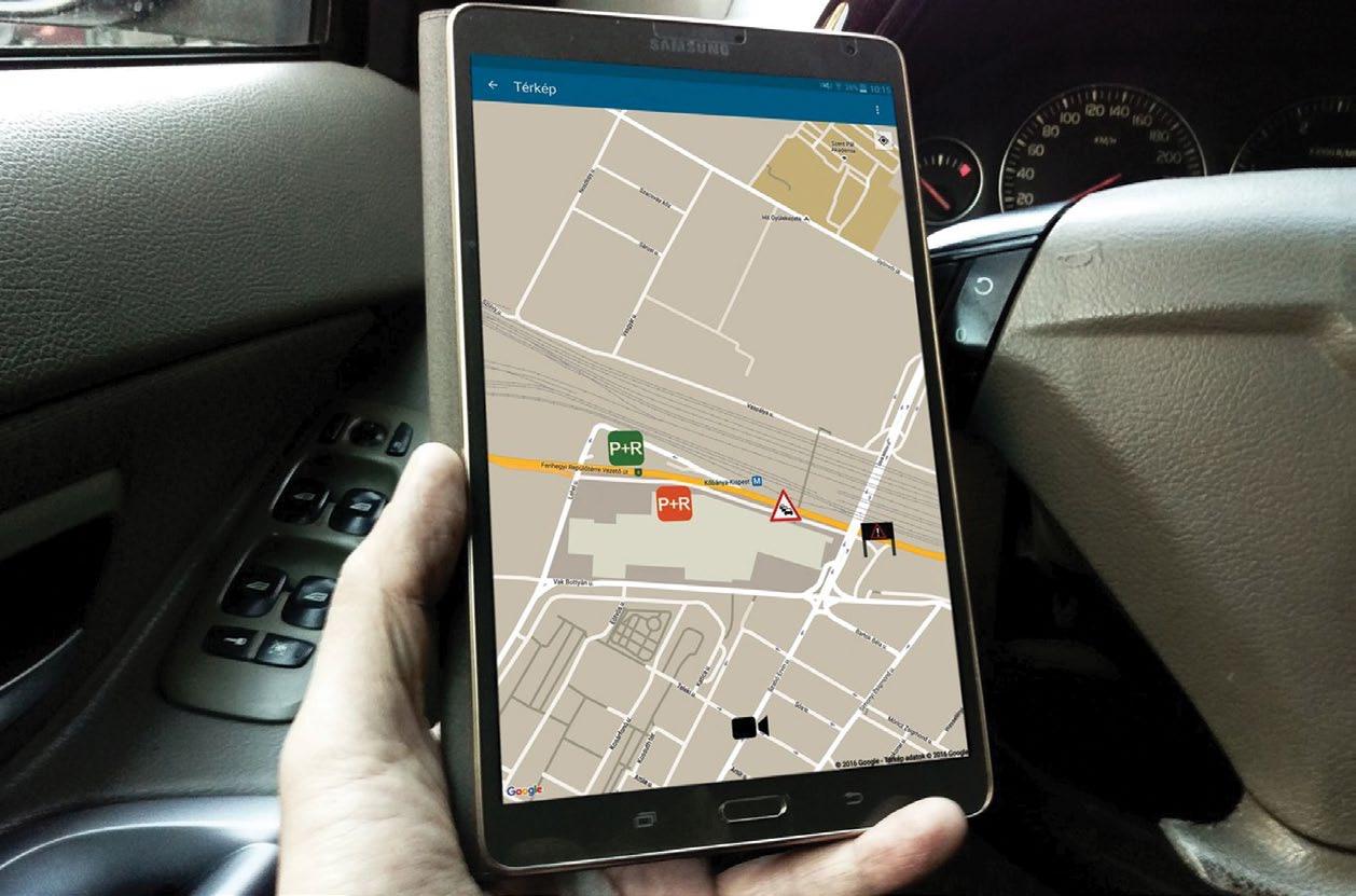
Central traffic control systems require high-precision real time traffic data, travel time data, and suitable intelligent roadside platforms for traffic management (e.g. WMS) across the entire network of Budapest. We operate more than 600 intelligent cameras for real time traffic monitoring and license plate recognition and guide more than 1,100 junctions with traffic lights. Along with the development of the central software functions it is also necessary to develop the traffic monitoring equipment and the connecting wired and wireless highspeed communication network. It contains recent developments of high speed optical, and WiFi systems, but we have begun plans for the near future for the construction of the base field of the C-ITS systems infrastructure on network elements directly and indirectly related to the TEN-T network for testing the urban application and in order to implement and extend it step by step.
Co-operation
In Hungary there are two main road operators, our company is responsible for road operations in Budapest, and Magyar Közút Nonprofit Zrt. (Hungarian Public Road Non-profit Pte Ltd Co) is responsible for the rest of the country.
On the agglomeration network – especially on the M0 ring roads and the connecting road of the capital – we cooperate with the operator of the national road network for implementation of action plans defined in TMP on operative as well as on strategic level. Cooperation is based in the development of the DATEX II data exchange platform, and the increase in the quantity of the data exchanged, supporting the high demand of data of C-ITS systems.
end-user information support
Along with the development of central systems and monitoring systems the third main aim is the development of a real-time on-field and on-line information system for road users, in order to forward an optimal traffic flow by informing them in real-time, dynamically and punctually, focusing primarily on the M0 ring road, the national road network and the border area of the capital’s network. The development of our online public platforms (web page and mobile applica-
tion) also includes expansion of the data published automatically to the vehicles by the central traffic management system and expansion of the data content of data scopes sent already. It also pertains to developments related to expanding the data scope to provide high quality services for cooperative vehicles.

metro engineer Department
The Metro Engineer Department of Budapest Közút – as a 100 per cent Municipality shareholder entity — was formed in 2013 to act as a transaction engineer for on-construction actions of the Metor4 metro-line to make it more efficient.
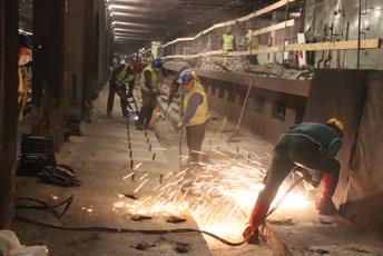
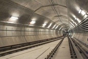
The Metro project and related infrastructural construction works have been successfully finished recently and our high-level engineering work was prized by many professional organisations. It is important to highlight one of the most important infrastructure works on the Metro line: the M1M7 multi-level (highway) junction. This is Hungary’s busiest traffic junction, and it took serious organisational and management work by the Department to keep the traffic smoothly running. The M4 metro-line construction by its nature is very complex work and has been a challenge for the team, especially as it is a deep construction project, crossing Danube River. Split-walls had to be applied for workplace protection. Train running controls, power supply, and fire protection systems are today’s high-end solutions, trains are running driverless without human control.
Right after handing over M4 the new, M3 reconstruction project preparation works began. M3 has been running for many decades so its technological level does not fit today’s requirements. The Department is responsible for whole technical QC and engineering tasks based on the agreement with the contractor, Budapest Public Transport. The work is divided into three phases and the construction started in 2017. The next stage is to hand over the Northern section and start the Southern phase, which involves closing that section down. The reconstruction covers the whole rails and side-rails, water drainage system, lighting system, cable console structures, cabling and isolation reconstruction will be done along the whole line. All stations will be installed with the highest quality fire protection and building monitoring system, as well as architectural renewal. It is an important task to allow clear access to the stations for disabled passengers, so elevators will be built. These elevators — mostly at deeper stations — are steep elevators next to escalators. n
Written by Dr. Kornél Almássy, CEO of Budapest Közút Zrt.