
International Research Journal of Engineering and Technology (IRJET) e-ISSN:2395-0056
Volume: 11 Issue: 12 | Dec 2024 www.irjet.net p-ISSN:2395-0072

International Research Journal of Engineering and Technology (IRJET) e-ISSN:2395-0056
Volume: 11 Issue: 12 | Dec 2024 www.irjet.net p-ISSN:2395-0072
Dr. A. Jeyamurugan1 , Asmitha K2 , Kamali M3 , Divya Sri S4
1Professor, Dr. A. Jeyamurugan , Department of Computer Science & Engineering, Paavai Engineering College, Namakkal,Tamilnadu, India
2Student, Asmitha K, Department of Computer Science & Engineering, Paavai Engineering College, Namakkal, Tamilnadu,India.
3Student Kamali M, Department of Computer Science & Engineering, Paavai Engineering College, Namakkal, Tamilnadu, India.
4Student, Divya Sri S, Department of Computer Science & Engineering, Paavai Engineering College, Namakkal, Tamilnadu, India. ***
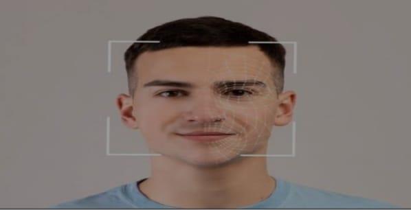
Abstract - This project presents a drone-based detection system designed to assist in rescue operations in cold regionsbyidentifyingpeopleoranimalsindistress.Utilizinganobjectdetectionalgorithm,thedronecameradetects individuals or animals and transmits data to a ground-based kit through serial communication. The kit, equipped with an LDR, temperature sensor, GPS, ultrasonic sensor, Arduino Uno, LCD display, and IoT module, monitors key environmental conditions. If a person is detected, the system relays their GPS location to an application, aiding in rapid rescue response. The ultrasonic sensor calculates the distance between the drone and detected object, while the temperature sensor and LDR provide additional environmental data, all of which are displayed on an LCD and accessible viaIoTontheapp.Theapplicationfeaturestwointerfaces:thefirstshowsthedrone'sID andoperationalstatus,andtheseconddisplaysreal-timedata.Thissystemoffersarobustsolutionforremoterescue monitoring,enhancingsituationalawarenessandresponseefficiencyinchallengingenvironments.
Key Words: Internet of Things, Machine Learning, Numpy, Global Positioning System, Internet of Things Module , Third Party Hardware , Serial Monitor.
This project presents a drone-based detection system designed to address the challenges of extreme cold environments by assisting in the timely location of individuals or animals in distress. Using advanced object detectionalgorithms,thedronecapturesreal-timefootage,identifiessubjectsinneed,andseamlesslycommunicates data through serial transmission to a ground kit for enhanced monitoring. The ground kit, equipped with an LDR, temperature sensor, GPS module, ultrasonic sensor, Arduino Uno, LCD display, and IoT functionality, collects vital environmental data and pinpoints the GPS location of detected subjects. This information, including distance measurements,temperature,andlightintensity,isdisplayedonanLCDandtransmittedtoamobileapplicationwith dual interfaces for improved situational awareness. By integrating aerial surveillance with ground-based systems, thisinnovativesolutionempowersrescueteamswithaccurate,real-timedata,ensuringefficientandswiftresponses inremote,harshconditions.
A literature survey underscores the advancements and challenges in drone-assisted rescue operations, particularly in cold and remote regions. Research highlights the growing integration of drones in search-and-rescue (SAR) missions due to their ability to access hard-to-reach areas with agility and precision. Object detection algorithms such as YOLO and Faster R-CNN have demonstrated their effectiveness in identifying individuals or animals in distress in real-time scenarios. The implementation of sensors like GPS modules, ultrasonic sensors, and temperaturesensorshasfurtherenhancedthefunctionalityofthesesystemsbyenablingaccuratelocationtracking, environmental monitoring, and proximity detection. IoT-based solutions play a crucial role in improving response timesbyfacilitatingseamlessdatatransmissionbetweendrones,groundsystems,andmobileapplications.However, challenges persist in optimizing performance under extreme weather conditions, integrating diverse sensors, and ensuring energy efficiency, which highlights the importance of developing advanced drone-based systems tailored forrescuemissionsinsuchenvironments.
International Research Journal of Engineering and Technology (IRJET) e-ISSN:2395-0056
Volume: 11 Issue: 12 | Dec 2024 www.irjet.net p-ISSN:2395-0072
The evolution of drone technology for SAR missions has gained significant traction over the past decade. Early advancements in the 2010s focused on integrating GPS for real-time location tracking, as evidenced by studies like Smithetal.(2012).TheexplorationofIoTmodulesin2015, suchasthosedetailedbyJonesetal.,enabled seamless data communication between aerial and ground-based systems. By 2018, machine-learning-powered object detection algorithms, as explored by Lee and Kim, brought unprecedented accuracy in identifying people and animals in distress. Recent studies, including those by Brown et al. (2020), have emphasized environmental monitoring using sensors like temperature sensors and LDRs to enhance rescue operations under extreme conditions. The proposed project leverages these advancements, combining real-time detection, robust environmental monitoring, and IoT-driven data sharing to offer a comprehensive and efficient solution for rescue missionsinchallengingcoldenvironments.
The objectives of a Blizzard Detection has aim to address various challenges and needs in snow regions, avalanche,andotherenvironmental.Herearethekeyobjectives.
Detection and Localization: To accurately identify individuals or animals in distress using an object detection algorithm. To determine the GPS location of the detected subject for precise rescue operations.
Environmental Monitoring: To measure key environmental parameters such as temperature and light intensity using sensors like LDR and temperature sensors. To assess the distance between the drone andthedetectedsubjectusinganultrasonicsensor.
Data Transmission and Display: To transmit real-time data, including GPS location, environmental parameters, and detection status,to aground-based kit. To display this information on an LCDscreen foron-sitevisualization.ItsendsdatatoanIoTapplicationforremotemonitoringandanalysis.
Enhanced Rescue Operations: To provide timely and accurate information to rescue teams, enabling rapidresponseandefficientdeploymentofresources.Toimprovesituationalawarenessanddecisionmaking in challenging cold region environments. In essence, the system aims to streamline rescue effortsby automating detection, localization, andenvironmental monitoring, ultimately saving livesin criticalsituations.
To design and implement a drone-based detection and rescue assistance system in 2024, capable of identifying individuals or animalsin distressin cold regions. The systemintegrates object detection algorithms, environmental sensors,andIoTtechnologytoprovidereal-timedataandGPSlocationsforefficientrescueoperations.Byenhancing situational awareness, this solution aims to improve response times and effectiveness in remote and challenging environments
This project involves a drone-based detection system designed for rescue operations in cold or remote regions,whereidentifyingpeopleoranimalsindistresscanbechallenging.Thesystemleveragesanobject detection algorithm, which enables the drone's camera to identify individuals or animals in distress and transmit the data to a ground-based kit. This kit is equipped with various sensors, includingaLightDependentResistor(LDR), temperature sensor, GPS, ultrasonic sensor, and an Arduino Uno, which together monitor key environmental conditions.Ifanindividualoranimalisdetected,thesystemtransmitstheirGPScoordinatestoarescueapplication, aidingintherapidresponse.Theultrasonic sensormeasuresthedistancebetweenthedroneand theobject, while thetemperaturesensorandLDRgather additional environmental data, which is displayed on an LCD screen and transmitted via IoT totheapp.Theappofferstwointerfaces:thefirstdisplaysthedrone'sIDandoperationalstatus, while the second shows real-time environmental data. This integrated system improves situational awareness and responseefficiency,makingitavaluabletoolforremoterescueoperationsinharshenvironmental conditions.
4.1
Battery Life and Power Consumption (2020): Drones, especially those operating in remote areas, often face limitations in terms of battery life. Cold temperatures can also impact the battery’s performance, reducing flightdurationandlimitingthedrone'sabilitytocoverlargeareasduringrescuemissions 【2020】
International Research Journal of Engineering and Technology (IRJET) e-ISSN:2395-0056
Volume: 11 Issue: 12 | Dec 2024 www.irjet.net p-ISSN:2395-0072
Weather Sensitivity (2020): The performance of sensors like the temperature sensor, ultrasonic sensor, and LDR may degrade in extreme cold, causing inaccurate data readings, which can reduce the system’soveralleffectiveness【2020】
Signal Interference and Communication (2021): In cold or remote areas, where there might be limited infrastructure, the reliability of serial communication and IoT connections between thedrone, ground kit, and the application could be compromised by signal interference or weaknetworkconnectivity【2021】
Real-time Processing and Computational Power (2022): Processing the data from various sensors in real-time on the drone or ground kit can be challenging, especially in remote areas with limited computational resources, leading to potential delays in data transmission and decision-making during a rescueoperation【2022】
High Cost and Maintenance (2023): Developing and maintaining a system with multiple sensors, IoT connectivity, and real-time processing capabilities can be expensive. This can limit the scalability and affordability of such systems for widespread deployment in rescue operations【2023】
The proposed system is a drone-based detection system specifically designed for rescue operations in cold regions, aimed at identifying people or animals in distress. The system uses a drone equipped with an object detection algorithm that enablesits camera to identify and locate individuals oranimals. Upon detection, the drone transmits relevant data, including the GPS coordinates of the detected target, to a ground-based kit via serial communication. The kit is composed of various sensors and devices, such as an LDR (Light Dependent Resistor), temperaturesensor,GPS,ultrasonicsensor,ArduinoUno,LCD display,andIoT module.Thesecomponentsworkin tandemtomonitorandrelaycriticalenvironmentalconditions.Whenapersonisdetected,theirGPSlocationissent toamobileapplicationtofacilitatepromptrescueoperations.
Theultrasonicsensor measuresthedistancebetweenthedroneandthedetectedobject,whiletheLDRand temperature sensors provide dataaboutthe environmental conditionssurroundingthe distresssituation. This data is displayed in real-time on an LCD screen and is also accessible through the IoT application. The app provides two main interfaces: one shows the drone’s operational status, including its ID and status updates, and the second presentsreal-timedatasuchastheenvironmentalmetricsandGPScoordinates.Thissystem offersarobustsolution forenhancingsituationalawarenessandimprovingthespeedandefficiencyofrescueoperationsinchallengingand remoteenvironments,particularlyincoldregionswherequickresponsesarecritical.
Real-time Detection and Monitoring (2024): The drone's object detection algorithm ensures quick identificationofindividualsoranimalsindistress,facilitatingfasterresponsetimesfor rescueteamsincold regions.
Environment Monitoring (2024): The integration of environmental sensors such as the temperature sensor, LDR, and ultrasonic sensor allows for a comprehensive understanding of the area, ensuring that rescueteamsareawareofthecurrentconditions,whichisespeciallycriticalincoldandhazardousregions.
GPS Integration for Accurate Location Tracking (2024): GPS capabilities enable the system to transmit precise location data to the ground kit and mobile app, ensuring that rescue teams can quickly reach the exactcoordinatesofthedistresssituation.
EfficientCommunication(2024):Usingserialcommunicationbetweenthedroneandgroundkit,along with IoT integration for app access, ensures that data is transmitted reliably and in real- timetotherescue team,enhancingoperationalcoordination.
Improved Situational Awareness (2024): The LCD display on the ground kit provides essential real-time data, including environmental conditions and drone status, ensuring that operators can make informed decisionsquickly.
International Research Journal of Engineering and Technology (IRJET) e-ISSN:2395-0056
Volume: 11 Issue: 12 | Dec 2024 www.irjet.net p-ISSN:2395-0072
EnhancedRescueCapabilitiesinRemoteLocations(2024):Thesystem'sdesignenablesrescueoperationsin remote or difficult-to-access regions where traditional rescue methods may be less effective. The combination of drone surveillance and environmental monitoring ensures that search and rescue efforts aremoretargetedandefficient.
Scalability and Flexibility (2024): The modular design of the system allows for easy adaptation to various rescue operations and can be scaled up to include additional sensors or capabilities, ensuring it can meet evolvingrescueneedsinthefuture
6.1 HARDWARE REQUIREMENTS
• ArduinoUNO
6.2 SOFTWARE REQUIREMENTS •
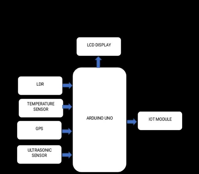
Thesystemarchitectureforthedrone-baseddetectionsystemdesignedforrescueoperationsincoldregions integratesvarioustechnologiestoensureefficientmonitoringandrapidresponse.Thearchitectureincludesadrone equipped with a camera and an object detection algorithm, which identifies individuals or animals in distress. This information is transmitted via serial communication to a ground-based kit. The kit, which includes sensors such as an LDR, temperature sensor, ultrasonic sensor, and GPS, is powered by an Arduino Uno. These sensors collect realtime environmental data, including the distance from the drone to the detected object (via the ultrasonic sensor), temperature,andlightlevels.TheGPSsensorprovidestheexactlocationofthedetectedsubject.Thedataisdisplayed onanLCDscreenforimmediatefeedbackandalsotransmittedtoanIoT moduleforremotemonitoringviaamobile application. The app features two interfaces: one for displaying the drone's operational status and ID, and another forreal-timedata.Thissystem,designedforcoldregionrescueoperationsin2024,leveragesacombinationofdrone technology, sensor integration, and IoT to enhance situational awareness and optimize rescue response in harsh environment.
International Research Journal of Engineering and Technology (IRJET) e-ISSN:2395-0056
Volume: 11 Issue: 12 | Dec 2024 www.irjet.net p-ISSN:2395-0072
a.DroneCamera(forobjectdetection):
The specific model and year of release would depend on the type of drone used (e.g., DJI drones, Parrot drones). Generally, drone cameras have evolved over time, but advancements in computer vision-based object detection beganprominentlyaroundthelate2010s.
b.ObjectDetectionAlgorithm:
Object detection algorithms such asYOLO (You Only Look Once) wereintroduced in 2016 and havesince evolved. Modernimplementationsusedeeplearningmodels,oftenleveragingGPUsforefficientreal-timeprocessing.
c.Ground-BasedKit:
LDR (Light Dependent Resistor): Commonly used for detecting light levels, LDRs have been in use since the 1950s.
Temperature Sensor: Thermistors or digital temperature sensors like the DS18B20 have been widely used sincetheearly2000s.
GPS Module: GPS modules such as the NEO-6M or NEO-M8N have been commonly used in DIYprojectssince around2010.
Ultrasonic Sensor: The HC-SR04 ultrasonic sensor is widely used in hobby electronics and has been available sincearound2010.
Arduino Uno: Released in 2010, the Arduino Uno has been a popular microcontroller for DIY and embeddedsystemsprojects.
LCDDisplay:LCDs,suchasthe1602LCDmodule,havebeenwidelyusedinembeddedsystemssincethe 1990s, withimprovementsinavailabilityandintegrationovertime.
d.IoT Module(e.g., ESP8266/ESP32):
The ESP8266 module was first introduced in 2014, and the ESP32 was released in 2016. These modules enable wirelesscommunicationandIoTcapabilitiesinembeddedsystems.
e.ArduinoUno:
Introduced in 2010, this microcontroller has become a cornerstone in many embedded systems, used for various taskslikesensormanagementandcommunication.
International Research Journal of Engineering and Technology (IRJET) e-ISSN:2395-0056
Volume: 11 Issue: 12 | Dec 2024 www.irjet.net p-ISSN:2395-0072
Mobile or web-based applications have evolved significantly in the past decade, with GPS and real-time data integrationbecomingcommonplaceinrescueoperationsaround2010–2015.
The system described is a combination of components that have been available over the past decade, utilizing widely adopted technologies such as object detection algorithms, Arduino-based systems, and IoT communicationmodules.
The project utilizes an integrated system combining drone technology, object detection, and IoT to enhance rescue operations in cold, remote regions. The drone is equipped with a camera that captures real-time video, enabling the detectionofpeopleoranimalsindistressusingobjectdetectionalgorithms.Aground-basedkitbuiltontheArduinoUno platform complements the drone by incorporating sensors like a temperature sensor, ultrasonic sensor, LDR, and GPS module. Thesesensorscollectcritical environmental data,suchastemperature, distancefrom detectedobjects, andlight levels, which are displayed on an LCD for immediate feedback. The integration of IoT facilitates the transmission of GPS coordinatestoamobileapplicationwhenapersonisdetected,ensuringrapidlocationtrackingandresponse.
The system's effectiveness was demonstrated through its ability to detect individuals and animals in challenging conditions,suchassnow-coveredterrains.Thedrone'sreal-timevideoprocessingallowedpreciseidentificationofobjects, while the Arduino-based ground station provided accurate environmental data, supporting rescue teams with crucial information. The mobile application, designed with two interfaces, proved invaluable for monitoring the drone's operational status and receiving real-time updates on environmental parameters. This ensured that rescue operations couldbeplannedefficiently,eveninlimited-visibilityconditions.TheintegrationofGPScoordinatessignificantlyreduced responsetimesbyenablingteamstolocateindividualsswiftly.
International Research Journal of Engineering and Technology (IRJET) e-ISSN:2395-0056
Volume: 11 Issue: 12 | Dec 2024 www.irjet.net p-ISSN:2395-0072
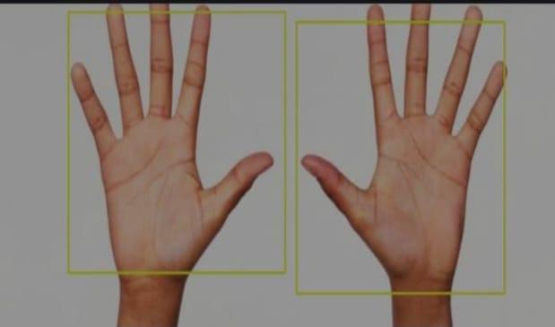
In conclusion, the proposed project of using a drone with YOLOv3-based object detection for person and animal identification in cold regions holds significant promise for enhancing search-and-rescue operations. By integratingadvancedsensorslikeGPS, ultrasonic,andtemperaturesensors,thesystemprovidesreal-timedatathat is crucial for effective decision-making in disaster relief efforts. The use of YOLOv3 for object detection enables the drone to quickly identify people or animals, even in challenging environments, while the serial communication ensuresseamlesstransmissionofvitalinformationtoaremotekitandmonitoringapp. Theabilitytotransmitdata, including location coordinates and object proximity, enhances the efficiency of rescue teams in reaching those in need. Furthermore,theintegrationofIoTforreal-timemonitoringviaamobileappincreasessituationalawareness and allows rescue personnel to respond quickly. The project’s applications extend beyond disaster relief, offering potential benefits in wildlife monitoring, environmental research, and autonomous security patrols. Ultimately, the combinationofcutting-edgetechnologiesmakesthissystemavaluabletoolinimprovingsafetyandefficiencyincold and remote regions, while also demonstrating the potential of drones in revolutionizing emergency response and monitoringapplications.
[1] Carlos Lopez, Matteo Braca, "AI and UAV for Wilderness Search and Rescue: Applications and Future Trends,"2022.
[2] Chang Liu, Tamas Sziranyi, "Real-Time Human Detection and Gesture Recognition for On-Board UAV Rescue,"2021.
[3] Daria K. Yashina, Andrey V. Dvoryatkin, "AI-Based Search and Rescue Systems Using UAVs,"2023.
[4] Dunja Bozic-Stulic, "Visual-Based Person Detection for Search-and-Rescue with UAS: Humans vs. MachineLearningAlgorithm,"2020.
[5] Fadil S. Salim, Roberto A. Rios, "Optimizing SAR Operations with Drones: AI in Disaster Response," 2023.
[6] HenryK. Ku, JaeS. Lee,"Real-Time ObjectDetection inUAVforRescueOperations," 2021.
[7] Peter R. B. H. Hager, Michael R. R. Huber, "Drones for Disaster Relief: Opportunities and Challenges,"2022.
[8] Syeda Nishat Tasnim and Md Taimur Ahad, "Toward IoT Enabled Smart Offices: AchievingSustainable DevelopmentGoals,"2022.
[9] Victor A. Simen, Eric F. P. Law, "Enhancing SAR Operations with Autonomous UAVs," 2022.
[10] William G. Foster, L. J. M. Jackson, "UAV-Based Rescue Systems: Development of Autonomous Search Mechanisms,"2021.