
International Research Journal of Engineering and Technology (IRJET) e-ISSN: 2395-0056
Volume: 11 Issue: 12 | Dec 2024 www.irjet.net p-ISSN: 2395-0072

International Research Journal of Engineering and Technology (IRJET) e-ISSN: 2395-0056
Volume: 11 Issue: 12 | Dec 2024 www.irjet.net p-ISSN: 2395-0072
Sani Aminu Shuaibu1 , Samuel Ndueso John 2, Joshua Sokowonci Mommoh3, Etinosa NomaOsaghe4, Ashraf Adam Ahmad5, Hayatu Idris Bulama6
1Department of Electrical Electronic Engineering, Nigerian Defence Academy, Kaduna, 800281, Nigeria
2Department of Electrical Electronic Engineering, Nigerian Defence Academy, Kaduna, 800281, Nigeria
3Department of Software Engineering, Mudiame University Irrua, Edo, 310112, Nigeria.
4Department of Electrical and Electronics Engineering, Olabisi Onabanjo University, Ogun, 120107, Nigeria.
5Department of Electrical Electronic Engineering, Nigerian Defence Academy, Kaduna, 800281, Nigeria
6Department of Electrical and Electronics Engineering, Air Force Institution of Technology, Kaduna, 800282, Nigeria ***
Abstract - As the need for mobile phones and fast data servicesgrows,sodoesthenumberofwirelesscommunication technologies. This shows how important accurate path loss prediction models are for improving network performance. Traditional empirical models, such as Okumura-Hata and COST-231Hata,oftenstruggletodeliverreliablepredictionsin complexurbanenvironmentsduetotheirlimitedadaptability to varying terrain and environmental factors. These limitations result in challenges such as poor coverage, signal interference, and suboptimal Quality of Service (QoS), especially in regions where networks are subject to unpredictable conditions. Existing models are often constrained by static configurations and outdated technologies. This studyproposes a novel pathloss prediction model using an Adaptive Neuro-Fuzzy Inference System (ANFIS) tailoredto a 4G LTE networkoperating at 2600 MHz withintheZaria Government ReservedArea (GRA) inNigeria. The model leverages a handheld spectrum analyzer, a GPS distance meter, and walk-test methodology to capture accurate path loss data. By integrating ANFIS with advanced statisticaloptimization,theproposedmodelachievessuperior predictiveperformancecomparedtoconventionalmodelssuch as Okumura-Hata, COST-231 Hata, Egli, and ECC-33. The results demonstrate a significant reduction in error metrics, with a Chi-square error of 1.252063 dB, an RMSE of 0.32145 dB, and the highest Coefficient of Determination (R² = 0.976). These outcomes highlight the model's exceptional accuracy, reliability, and adaptability, paving the way for enhanced wireless network performance optimization and supporting the deployment of next-generation 5G networks in similar urban environments.
Key Words: Path Loss Prediction, Adaptive Neuro-Fuzzy Inference System (ANFIS), 4G LTE, Wireless Communication, Network Performance Optimization.
The demand for personal communication devices such as smartphones and tablets, combined with the need for
ubiquitousdataaccess,hasdrivensignificantadvancements in wireless mobile communication technologies. Cellular networks have undergone remarkable evolution, progressingfromthefirstgeneration(1G)totheimminent fifth generation (5G) [1]. Each successive generation has introduced substantial improvements in technological capacity,datatransmissionspeeds,andservicequalityfor users.Thisevolutionunderscoresthetransformativeimpact of wireless communication in modern society. The initial phase of wireless networks utilized analog technology, primarilysupportingvoicecommunicationwithlimiteddata services. Operating at a modest 2.4 kbps, 1G offered basic functionality without features like caller ID or roaming capabilities. Transitioning to digital technology, 2G significantly enhanced data transmission rates (up to 64 kbps)andintroducedcallerID,roaming,andsupportfortext messaging[2],[3].While2Gimprovednetworkperformance, itsdatatransmissionspeedsareslowbymodernstandards. Oftenhailedasa"datarevolution,"3Gnetworksdelivered data rates of 144 kbps for mobile users, 384 kbps for walkingusers,andupto2Mbpsforstationaryusers.This enabledbroadbandapplicationslikelargeemailtransfers, videostreaming,andsecureonlinecommunication,marking asignificantleapinmobiletechnology[4]-[6].4Gnetworks represent a substantial improvement over 3G, achieving speedsupto1.2Gbps,approximately20timesfasterthan 3G. Operating on the 700 MHz, 1800 MHz, and 2600 MHz frequencybands,4Genablesseamlessdownloadingoflarge files,streamingofhigh-qualityvideos,andnewserviceslike mobile payments, video conferencing, and cloud-based gaming.Despiterapidtechnologicaladvancements,wireless mobile networks in regions like Nigeria face persistent challenges.Theseincludepoorcoverage,frequentcalldrops, signal interference, network congestion, and suboptimal quality of service (QoS) [7]. These issues primarily arise fromtheunpredictableandcomplexnatureofmobileradio channels, which are influenced by environmental factors such as shadowing, path loss, and interference. Effective mitigation of these challenges requires robust network designandaccuratepredictionmodelsforsignalbehavior.
International Research Journal of Engineering and Technology (IRJET) e-ISSN: 2395-0056
Volume: 11 Issue: 12 | Dec 2024 www.irjet.net p-ISSN: 2395-0072
Thisresearchfocusesonpathloss(PL),whichstandsasa pivotal element within wireless communication systems, delineatingthedeclineinsignalpotencyduringitsjourney fromthetransmittertothereceiveracrosstheatmosphere oralternatemediums.Thismetricquantifiesthemeanradio frequency (RF) attenuation, indicative of signal diminishment owing to factors like distance, interference, reflection,andabsorption.Also,pathlossdenotesthedecline intransmittedsignalstrengthuponitsarrivalatthereceiver followingtraversalthroughmultipleroutes.Thisdecrement is typically articulated as the disparity in decibels (dB) betweenthepowerofthetransmittedsignalandthatofthe received signal. This loss can be determined by using empirical or theoretical models that take into account various parameters such as frequency, distance, environment, and antenna characteristics. Thus, various pathlosspropagationmodelsareusedtopredictthefading behavior of a radio signal, which is useful in network planningtoensureefficientnetworkperformanceandgood QoS[8],[9].Propagationlossmodelsarestudiedtopredict the signal behaviour of a particular geographical location, and these are used to optimize telecommunications standardsforimprovednetworkperformanceandseamless service delivery to mobile users. This study focuses on forecasting the path loss characteristics within a GovernmentReservedAreainZaria(GRA),fora4Gmobile telephone network (MTN) network. The Zaria GRA was selectedforthisresearchduetoitsdiverseurbanandsemiurban characteristics, which provide a representative environmentforstudyingwirelesssignalpropagation.The area features varying terrain, building densities, and infrastructure, making it an ideal location to evaluate the accuracyandrobustnessoftheproposedpathlossmodelfor differentreal-worldscenarios.
Recentresearchbasedondifferenttechniquesforpredicting path loss such as the one carried out by [10] proposed a hybrid wavelet-genetic algorithm technique for the developmentandcomparisonofpathlossmodels.Apopular modelknownastheCOST231wascomparedwithGAand Wavelet-GA, in terms of root mean square error (RMSE), meanabsoluteerror(MAE),andcorrelationcoefficient(R). ThefindingsindicatethattheproposedWavelet-GAmodel achieved RMSE values of 2.896, 4.715, 1.945, and 3.498, comparedtotheGAmodel'svaluesof3.47,5.49,3.69,and 4.55,andtheCOST231model'svaluesof78.13,74.74,84.30, and76.54.Similarly,theMAEfortheWavelet-GAmodelwas 2.38,3.92,1.45,and2.95,whiletheGAmodelrecorded2.83, 4.66,2.84,and3.84,andtheCOST231modelrecorded78.04, 74.37, 84.36, and 76.39. Furthermore, the correlation analysis revealed that the Wavelet-GA, GA, and COST231 models had correlations with measured data of 93.3%, 90.8%,and90.8%;83.9%,79.6%,and79.6%;92.1%,76.9%, and76.9%;and86.3%,78.4%,and78.4%forsites1,2, 3, and4,respectively.Validationresultsfurtherconfirmedthat the Wavelet-GA model is 99.2% effective and suitable for applicationinAwka,Nigeria.
[11],employedanAdaptiveNeuro-FuzzyInferenceSystem to predict path loss in a Ruby mango plantation. In this study, path loss measurements were conducted in a Ruby mango plantation at a frequency of 433MHz. An adaptive neuro-fuzzyinferencesystem(ANFIS)wasthenappliedto predictpathloss.TheANFISutilizedtwoinputparameters for the prediction: distance and antenna height correspondingtodifferenttreelevels(trunk,bottomcanopy, middle canopy, and top canopy). The performance of the ANFISwasassessedbycomparingit withcommonlyused empiricalpathlossmodelsfromtheliterature.Theresults showed that the ANFIS provided superior prediction accuracy and high sensitivity compared to the empirical models,althoughitsperformancevarieddependingonthe treelevel.
[12]proposedanAdaptiveNeuro-FuzzyInferenceSystemBased Near-Ground Path Loss Propagation Model for WirelessSensorNetworkCommunicationinForest,Jungle, andOpenDirtRoadSettings.ThestudyexaminedtheLoRa path loss propagation model for near-ground communication,focusingonlowantennaheights(lessthan 30 cm). The models were validated using RMSE and MAE metrics. The Fuzzy ANFIS model demonstrated the best performance,achievinganRMSEof0.88andanMAEof1.61 at433MHzinopendirtroadenvironments.Theoptimized FITU-RNearGroundmodelachievedanRMSEof4.08andan MAE of 14.84 at 868 MHz in forest and dirt road settings, respectively.TheOkumura-HatamodelrecordedanRMSEof 6.32andanMAEof26.12at868MHzinforests.Finally,the ITU-RMaximumAttenuationFreeSpacemodelachievedan RMSEof9.58inforestsand anMAEof38.48in jungles at 868MHz.
[13], developed a path loss model based on machine learning. This research, compared data simulations using three different models: Artificial Neural Network (ANN), SupportVectorMachine(SVM),andconventionalMultilinear Regression (MLR). The performance of these models was evaluated using measured data and assessed through various efficiency metrics, including the Coefficient of Determination (R²), Root Mean Square Error (RMSE) and Mean Square Error (MSE). The results indicated that the ANNmodelperformedslightlybetterthantheSVMmodelin modelling all inputs. Additionally, both the ANN and SVM modelsoutperformedtheMLRmodelinpathlossprediction. Consequently,ANNisrecommendedforestimatingpathloss.
[14] proposed the use of machine learning for path loss prediction in the Tropical Region. This study employed machine learning techniques AdaBoost, Support Vector Regression(SVR),andBackPropagationNeuralNetworks (BPNNs) to develop path-loss models for Akure metropolis,OndoState,Nigeria.Experimentalmeasurements wereconductedforthreebroadcastingstations:OSRC(96.5 MHz), Orange FM (94.5 MHz), and FUTA FM (93.1 MHz). Machine learning models were designed for path loss predictionatvariouspointsandcomparedwithmeasured
International Research Journal of Engineering and Technology (IRJET) e-ISSN: 2395-0056
Volume: 11 Issue: 12 | Dec 2024 www.irjet.net p-ISSN: 2395-0072
data. For OSRC, RMSEs for AdaBoost, SVR, BPNN, and the log-distancemodelwere4.15dB,6.22dB,6.75dB,and1.41 dB, respectively. To address limited samples at new frequencies,ahybridframeworkcombiningclassicalmodels and machine learning algorithms was developed. The classical model generated additional training data to enhancepredictions.ForOrangeFMandFUTAFM,RMSEs with the hybrid approach were 1.77 dB, 1.52 dB, 1.45 dB, and 2.61 dB for AdaBoost, SVR, BPNN, and log-distance models,respectively.Addingclassicalmodel-generateddata reducedRMSEsfurtherto1.81dB,1.63dB,1.45dB,and1.88 dB,respectively.
[15] presented the use of ANFIS to develop a path loss prediction model for GSM and WCDMA Bands in Urban Areas. This study examined the impact of the number of Membership Functions (MFs) on prediction accuracy. The resultsshowedthattheANFISmodeloutperformedtheHata, Cost-231,Egli,andECC-33 modelsinurbanareasof Kano and Abuja. Additionally, increasing the number of MFs enhanced the RMSE performance, particularly with the generalized bell-shaped MF. Overall, the findings demonstrate the effectiveness and reliability of the ANFIS model in improving prediction accuracy compared to traditionalpropagationmodels.
[16],employedtheuseofanAdaptiveNeuro-fuzzyInference Systemforthedevelopmentofapathlosspredictionmodel. This study developed a path-loss model for predicting wirelessHigh-SpeedPacketAccess(HSPA)networksignals inIbadan,Nigeria,usinganAdaptiveNeuro-FuzzyInference System (ANFIS). Received Signal Strength (RSS) measurementswerecollectedfromthreeBaseTransmitting Stations (BTS) operating at 2100 MHz in Ojo, Dugbe, and Challenge areas of Ibadan through Drive Tests. The equipmentusedincludedTEMSphones,GPS,andacomputer system.Inputvariables suchastransmittingandreceiving antenna heights, carrier frequency, and distance were utilized to train the ANFIS model and evaluate traditional modelslikeOkumura-Hata,COST-231,andfreespace.The ANFISmodel,designed with fivelayers,wastrainedusing Least Squares Error (LSE) and Gradient Descent (GD) methods.ItsperformancewasassessedusingMeanSquare Error (MSE) and Root Mean Square Error (RMSE), demonstrating improved accuracy compared to the conventionalmodels.
Overall,currentmethodshaveshownexcellentperformance in predicting path loss, although they have focused on comparing well-established empirical models with field measurementstoidentifythebestmodelforspecificstudy areas.However,thesestudiesoftenoverlookthefine-tuning ofthesemodelsusingadvancedstatisticaltechniques,which couldimprovepredictionaccuracy.Whilesomestudieshave developedANFIS-basedmodels,mosthavebeen based on older2Gand3Gtechnologies,withvariationsinthetesting tools,frequencies,measurementtypes,andstudyareas,and mostexistingmodelsaredesignedforstaticconditionsor
environmentsthatassumeafixedconfigurationofobstacles and terrain. This research seeks to improve on existing worksbyusingahandheldspectrumanalyzerat2600MHz for4GLTE,applyingawalktestscenarioandGPSdistance meter to capture path loss data, and leveraging ANFIS to statistically enhance path loss predictions. This approach will provide a more accurate, realistic, and reliable model tailored tomodern wirelesscommunicationsystems.This studyseekstoforecastthepropagationlosscharacteristics withinZariaGRAinNigeriafora4GMTNnetworktopave thewayforfuture5Gnetworkplanninganddeploymentin ZariaGRA.
This section presents the methodology used in the development of the path loss prediction model using an adaptiveneuro-fuzzyinferencesystemforenhancedwireless networkperformanceoptimizationin urbanenvironments. The study commenced with the acquisition of Received SignalStrength(RSS)measurementsemittedbya4GMTN base station within the designated study area. These measurements are systematically recorded at 100-meter intervals, extending up to a distance of 1500 meters. Subsequently, path loss values are derived using the establishedpathlossformulainequations(1)and(2)andare benchmarkedagainstcomputationsobtainedfromstandard empiricalmodels,includingOkumura-Hata,COST-231Hata, Egli,andECC-33.
Theextractedpathlossdataservesasthefoundationalinput for designing an Adaptive Neuro-Fuzzy Inference System (ANFIS) aimed at developing a more robust and adaptive pathlosspredictionmodel.Theperformanceoftheproposed ANFIS-based model is rigorously evaluated using key statistical metrics, such as Chi-square error, root mean squareerror(RMSE),coefficientofdetermination(R²),and meanabsoluteerror(MAE),toensureaccuracy,reliability, andpredictiveefficiency.
2.1.1 Study base station and measurement environment
Thefieldmeasurementactivitieswereconductedwithinthe open expanse of Zaria GRA, located at the geographical coordinates 11.112989°N latitude and 7.715167°W longitude.Thisareaisclassifiedasasuburbanenvironment, characterized by a heterogeneous landscape comprising high-risestructures,densevegetation,prominentbillboards, strategically positioned lamp posts, and well-maintained tarredroadways.Thearchitecturallandscapepredominantly featuresmultistorybuildingswithheightsrangingfromtwo tothreefloors,servingdiversefunctionalpurposessuchas hospitality establishments, educational institutions, and residentialcomplexes.Thevegetationprofileoftheregionis dominatedbyconiferoustrees,includingAfricanmahogany (Khayasenegalensis)andParkiaspecies(Parkiabiglobosa).
International Research Journal of Engineering and Technology (IRJET) e-ISSN: 2395-0056
Volume: 11 Issue: 12 | Dec 2024 www.irjet.net p-ISSN: 2395-0072
Alesserproportionofdeciduoustreespecies,suchasNeem (Azadirachtaindica),Tamarind(Tamarindusindica),Mango (Mangifera indica), and Shea butter trees (Vitellaria paradoxa), are also present, contributing to the ecological diversityofthearea.Fig-1showsageneraloverviewofthe researchmethodology.
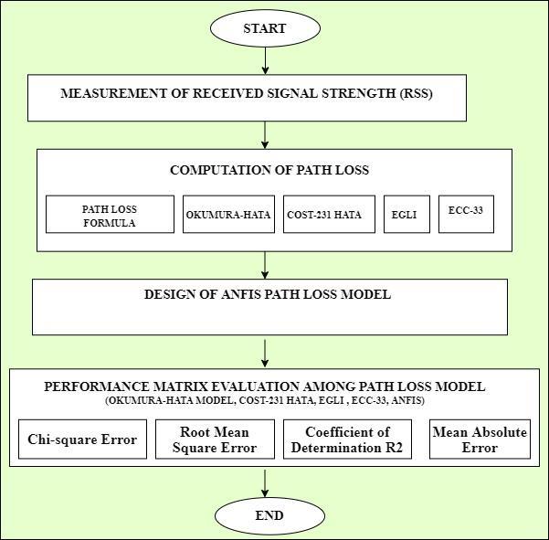
Fig -1:Ageneraloverviewoftheresearchmethodology
Fig-2presentsadetailedvisualrepresentationofthestudy area,capturingtheenvironmentalcomplexitythrough the interplay of dense foliage, towering tree canopies, and ruggedrockformations.Thisimageryservestohighlightthe diversegeographical andenvironmental characteristics of theoutdoormeasurementsitewithinZariaGRA,providing essential context for the propagation study. The study environmentispredominantlycharacterizedbyNon-Lineof Sight(NLOS)signalpropagation,owingtotheprevalenceof denselypackedobstaclesthatlimittheestablishmentof a clear Line of Sight (LOS) to the base station. The NLOS conditions are primarily driven by signal attenuation mechanismssuchasmultiplereflections,absorptions,and diffractionscausedbyinterveningobstacles,includingflatroofedbuildings,shorttrees,andmovingvehicles.Further attenuationisobservedduetotheabsorptivepropertiesof solidsurfacessuchasconcretepavementsandasphaltroads, which significantly impact ground-reflected wave propagation. Additionally, structural and vegetative obstructionscandisruptthecontinuityofground-reflected wavepathsunderspecificconditions

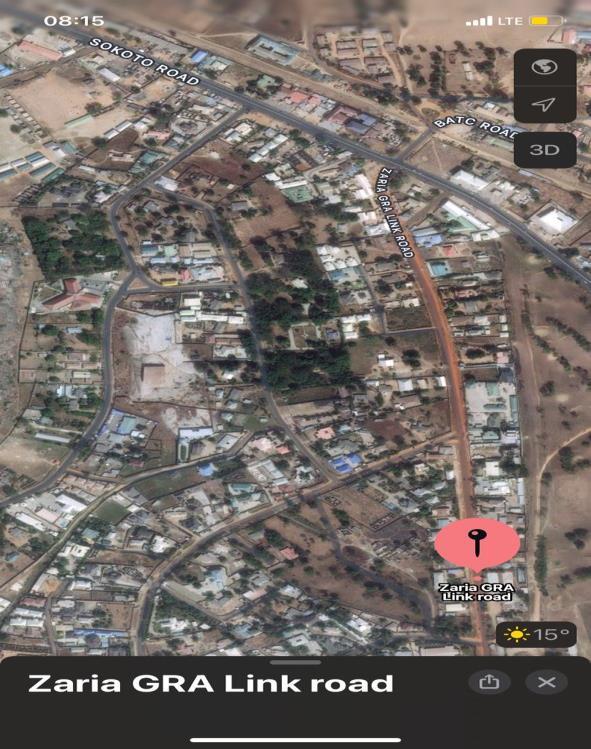
Furthermore,asatelliteimageryperspectiveofasegmentof thestudyareaisdepictedinFig-3,providingamacroscopic view that complements the detailed environmental descriptionsandsupportsthecontextualunderstandingof signalpropagationchallengeswithintheregion.
2.1.2 Base station parameters and Received Signal Strength measurement
The field measurements originating from the base station transmitter were conducted along three distinct routes, designated as radio paths I, II, and III. The measurement campaignutilizedspecializedinstrumentation,includinga BKPrecision2658Ahandheldspectrumanalyzer,alaptop
International Research Journal of Engineering and Technology (IRJET) e-ISSN: 2395-0056
Volume: 11 Issue: 12 | Dec 2024 www.irjet.net p-ISSN: 2395-0072
computer, and a global positioning system (GPS) distance meter.Thespectrumanalyzerwasemployedtocapturethe ReceivedSignalStrength(RSS),whiletheGPSdistancemeter was used to precisely measure the separation distances betweenthetransmitterandreceiver(T-R).Thecaptured RSS data were subsequently transferred to a laptop for detailed post-processing and analysis. The technical specificationsofthebasestationandmobilestationunder considerationaresummarizedinTable1.Keyparameters includethebasestationantennaheightof40m,themobile station antenna height of 1.5 m, and a transmission frequency of 2600MHz. This rigorous measurement methodology, coupled with the use of standardized equipment, ensures the accuracy and reliability of the collecteddata.Theresultsfromthisfieldstudyarefurther compared with predictions from well-established propagation models to comprehensively evaluate radio signal behaviour within the study environment. This comparativeanalysisunderpinsthedevelopmentofrobust andprecisepredictivemodelsforradiowavepropagationin thedesignatedarea.
Table -1: BaseandMobileStationParameters
Theregionwassegmentedintothreeroutestoensure comprehensivedatacollectionthatconsidersallaspectsof theGRA.Theseroutesinclude;
i. Starting from the base station and proceeding throughDorawaRoad,ParkRoad,andWraffRoad uptoZariaGRAlinkRoad.
ii. Commencingfromthebasestationandtraversing Main Road, Aminu Road, and BATC Road up to SokotoRoad.
iii. Originating from the base station and passing throughGRApolicestation,ZariaHighStreet,upto CommonwealthRoad
Theseroutescollectivelyencompasstheheterogeneous features of the urban environment, enabling the developmentofanAdaptiveNeuro-FuzzyInferenceSystem (ANFIS)-based path loss model tailored for enhanced wireless network performance optimization in complex urbanenvironments.
TheMTNBaseStation(BS)locatedonDorawaRoadin Zaria GRAoperateswithina radial coveragearea of2km, classifyingitasamicrocell.Experimentaldatacollectionwas conducted within this coverage area, spanning distances from100mto1500malongthreedesignatedradiopaths.
ThesemeasurementswerecarriedoutinSeptember2023 during daylight hours to ensure consistency in environmentalconditions.Foreachradiopath,theReceived SignalStrength(RSS),denotedaspowerreceived(Pr),was measuredatareferencedistanceof100mfromtheBSand subsequentlyat100mintervalsupto1500m.TheNon-Line of Sight (NLOS) scenarios encountered along the three routesposeddistinctpropagationchallenges.AlongRoute III, a substantial obstacle in the form of a large rock obstructed the signal path between Commonwealth Road and Sokoto Road. Similarly, Route II experienced signal degradationduetoarowofdenselypackedhigh-risetrees obstructingthelink betweenBATCRoadandAppleWhite Restaurant. Each route was subjected to 15 measurement points, resulting in a total of 45 RSS readings across all routes. This extensive dataset was deemed critical for improvingtheprecisionofthepathlosspredictionmodel.
The Received Signal Strength (RSS) presented in Table 2 exhibits a general trend of attenuation with increasing distance from the Base Station (BS) to the Mobile Station (MS), consistent with theoretical path loss expectations. However,specificdeviationsfromthistrendareobservedat certain measurement points, where the RSS temporarily increasesbeforeresumingitsdecline.Theseanomaliescan beattributedprimarilytotheundulatingtopographyofthe study area. The terrain's variability introduces diffraction and multipath effects, resulting in fluctuations in signal reception. These effects are further compounded by the presenceofdensevegetationandtallbuildingsalongcertain routes,whichactasadditionalsourcesofsignalattenuation andscattering.Routeswithhigherconcentrationsoffoliage orsignificantstructural obstructionstend to exhibit more pronounced RSS variability, driven by factors such as reflection,absorption,anddiffractionaroundobstacles.This complex interplay of environmental factors highlights the need for advanced modelling techniques to accurately predict RSS behavior in such heterogeneous urban landscapes.
Path loss (PL) is a fundamental parameter in wireless communicationsystems,quantifyingthereductioninsignal strengthasitpropagatesfromthetransmittertothereceiver through the atmosphere or other mediums. It serves as a criticalcomponentinchannelmodeling,characterizingthe attenuation of radio frequency(RF)power density during signal propagation.Pathlossencompassesthecumulative effects of distance-dependent attenuation, interference, reflection,diffraction,andabsorption,allofwhichcontribute to the degradation of signal quality. Mathematically, path lossisexpressedasthelogarithmicdifference,typicallyin decibels(dB), betweenthe transmitted power(Pt)andthe received power (Pr) at the receiver, given by equation 1 [17],[18]
Volume: 11 Issue: 12 | Dec 2024 www.irjet.net p-ISSN: 2395-0072

where d represents the separation distance between the transmitter and receiver. This metric provides a mean representationofRFattenuation,accountingforthesignal's traversal through multiple propagation paths, including direct,reflected,anddiffractedroutes.Bymodelingthepath loss,researcherscan accuratelypredictsignal behavior in diverseenvironments,enablingtheoptimizationofwireless networkperformance.Also,understandingthetransmission capacitiesofdifferentwirelesscommunicationtechnologies requires the use of precise path loss estimations. When planning the propagation of radio waves and installing communicationstechnologies,itcanbehelpfultocompute losses. A clear understanding of the best locations for transmitting and receiving station installations will come from an efficient path loss computation, which will save networkprovidersmoneyandgiveusersastrongersignal.
Themacro-cellcoverageplanningforurbanandsuburban environmentscommonlyreliesonahybridmodelderived from the foundational works of Okumura and Hata. Okumura's model, based on extensive empirical field measurements conducted in Japan, accounts for various factorsinfluencingsignalattenuation,suchascluttertype, transmitterheight,receiverheight,transmissionpower,and operating frequency. It highlights the reduction in signal strengthduetoreflection,diffraction,andscattering,which resultsinattenuationexceedingthepredictionsofthefreespacepathlossmodel.BuildinguponOkumura'sempirical data, Hata developed a set of mathematical equations to predictpathlossunderdifferentclutterconditions.TheHata modelisdefinedforfrequenciesrangingfrom150MHzto 1500MHzbutcanbeextrapolatedforfrequenciesupto4 GHz.Itcoversseparationdistancesbetweenthebasestation (BS)andmobilestation(MS)rangingfrom1kmto20km andaccountsforantennaheightsbetween1mand10m.By incorporatingcriticalenvironmentalandgeometricfactors, Hata'smodel providesa moreaccurateestimationofpath loss,makingitawidelyadoptedtoolformacro-cellcoverage planninginbothurbanandsuburbansettings[19].
Table -2: Received Signal Strength (RSS)
Thegeneralformofthepathloss(PL)indecibels(dB)for urban areas is expressed through the following equations (2)-(4)[20],[21]. (2) (3) (4)
Thegivenequationsdescribearelationshipbetweenvarious factorsthataffectthelossesinasignaltransmissionsystem. Itstatesthattherearetwofixedlosses,AandB,whichare influencedbythefrequencyofthesignalbeingtransmitted. Thevalueoffrequency,denotedbyfandmeasuredinMHz, playsacrucialroleindeterminingtheselosses.Apartfrom frequency, the statement mentions two other factors that impactsignallosses.Thefirstfactoristheheightofthebase stationantenna,hb,whichismeasuredinmeters.Thesecond factor is the height of the mobile station antenna, hm, also measuredinmeters.
TheCOST-231Hatamodel,anextensionoftheoriginalHataOkumura model, stands as a prominent empirical propagation model in the telecommunications industry, specifically tailored for urban environments. Developed under the auspices of the European Telecommunications StandardsInstitute(ETSI),thismodeliswidelyregardedfor its capability to estimate path loss by integrating several critical parameters, including environmental factors, separationdistancebetweenthetransmitterandreceiver, carrier frequency, and the effective heights of both the transmitting and receiving antennas [22]. Designed to operatewithinafrequencyrangeof500MHzto2000MHz, themodelincorporatescorrectionsforvariousterrainand morphologicalconditions,enablingitsapplicationacrossa range of urban and suburban scenarios. Its formulation considers the influence of antenna height on signal propagation,introducingspecificcoefficientstoaccountfor small and medium-sized city environments versus
International Research Journal of Engineering and Technology (IRJET) e-ISSN: 2395-0056
Volume: 11 Issue: 12 | Dec 2024 www.irjet.net p-ISSN: 2395-0072
metropolitanareas.Owingtoitsrobustpredictiveaccuracy and practical applicability, the COST-231 Hata model has become a cornerstone in the design and optimization of wirelesscommunicationnetworks,contributingtoenhanced servicequality,improvedspectrumutilization,andefficient resource allocation [23],[24]. Its adaptability allows telecommunications engineers and researchers to refine network designs across diverse geographical and environmentalcontexts,ensuringreliableconnectivityand optimalsystemperformance.
ThemathematicalrepresentationofpathlossintheCOST231 Hata model is expressed as shown in equation (5) encompassing terms that reflect frequency dependency, distance scaling, and environment-specific corrections, makingitapowerfultoolforsophisticatednetworkplanning andanalysis[25].
The Egli model is a classical empirical model tailored for cellular communication scenarios, particularly where one antennaremainsstationary(suchasabasestation)andthe other is mobile (e.g., a handheld device). This model is specifically applicable in environments characterized by irregularterrain,wherethetransmissionpathisinfluenced bynaturalobstructionssuchashillsorunevensurfaces.The Egli model provides a reliable framework for estimating signalattenuationinsuchscenarios,consideringfactorslike antenna heights and operating frequency. Typically, it is mosteffectiveforfrequenciesintherangeof40MHzto900 MHz, making it suitable for applications like land-mobile radioandearlycellularsystems.Themodelaccountsforthe power losses associated with terrain obstructions, employingasimplifiedapproachthatofferspracticalutility innetworkdesignandplanning[26],[27].
FirstintroducedbyJohnEgliinhisseminal1957paperthis terrain-specificmodelcalculatespathloss,oftenexpressed indecibels(dB),asafunctionofdistanceandothersystem parameters. The formula encapsulating the Egli model is presentedinequation(6),whereitscomponentsreflectthe dependenceonantennaheights,operationalfrequency,and theterraintype,thusservingasavaluabletoolforanalyzing and predicting propagation characteristics in complex terrains[28].
(6)
where,GbistheBSantennagain,GmistheMSantennagain, hb and hm are the BS and MS antenna heights in meters respectively, d is the distance between the BS and MS in metersalso,andfisthefrequencyoftransmissioninMHz.
Themodelissuitableforuseinmobilesystemsinthebands of 3MHz-3GHz. The model takes into cognizance the frequency,antennaheightandpolarization,necessitatingan agreementbetweentheplainearthlossandthemeasured values.
The ECC-33 path loss model was developed by Electronic Communication Committee (ECC). This model was extrapolatedfromoriginalmeasurementsbyOkumuraand modified its assumptions. The Okumura model was technicallyextendedforfrequenciesgreaterthan3GHzupto 3.5GHzbytheECC-3path-lossmodel.Themodeldefinesthe pathlossasshowninEq.(7)[29]. (7)
WhereAfsisfreespaceattenuation,Abmisbasicmedianpath loss,GtisbasestationantennaheightgainfactorandGr is mobilestationantennaheightgainfactor.
Thesearesequentiallydefinedasinequation(8)-(10)
(8)

Formediumcityenvironment,Grisdefinedasinequation (11)[30]:
(11)
wherefisthefrequencyinGHz.
AdaptiveNeuro-FuzzyInferenceSystems(ANFIS)represent a classofadvanced,adaptableneural networksthatshare functionalequivalencewithfuzzyinferencesystems.They offer a powerful combination of attributes, including learning capabilities, adaptability, and nonlinear, timevariant problem-solving capabilities characteristic of ArtificialNeuralNetworks.ANFISsystemsalsoincorporate thecriticalconceptsofapproximatereasoningandeffective treatmentofinformationprovidedbythefuzzysettheory, allowing them to operate at high levels of accuracy and efficiency in a variety of applications. By seamlessly integratingfuzzylogicandneuralnetworks,ANFISprovides a sophisticated, versatile tool for handling complex realworldproblems[31],[32].
This study utilized the Adaptive Neuro-Fuzzy Inference System(ANFIS)totrainthecollectedpathlossdata,aiming
International Research Journal of Engineering and Technology (IRJET) e-ISSN: 2395-0056
Volume: 11 Issue: 12 | Dec 2024 www.irjet.net p-ISSN: 2395-0072
toimproveadaptabilityandpredictionprecisionbeyondthe capabilitiesofempiricalmodelsforerrorrectification.The approach involved employing Frequency, Base station antennaheight,MobilestationantennaheightandDistance asinputvariables, while the measured pathloss values at designateddistancesactedasoutputvariables.Tofacilitate the training, a Hybrid learning algorithm was employed, whichamalgamatestheLeastSquareError(LSE)technique for adjusting Consequent parameters and the Gradient Descent(GD)methodforupdatingPremiseparameters.
2.3.1 The ANFIS architecture.
Theadaptivenetwork-basedfuzzyinferencesystem(ANFIS) isacomputationaltechniquethatisutilizedtosolvecomplex problemsrelatedtoparameteridentification.Itemploys a hybridlearningrulethatcombinesthestrengthsofthebackpropagationgradientdescentandtheleast-squaresmethod, which enables it to efficiently and accurately identify the parameters in a given system. By using fuzzy logic and neuralnetworktechnology,ANFIScanmodelthebehaviorof complex systems that are difficult to describe mathematically.Thisapproachoffersarobustandversatile methodfortacklingawiderangeofproblems,particularly thosethatinvolveuncertaintyorambiguityintheunderlying data.WithANFIS,itispossibletoachievehighaccuracyand efficiencyinparameteridentification,makingitavaluable tool for various fields, including engineering, finance, and medicine[33].
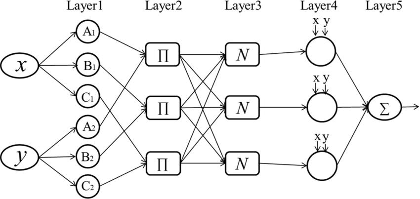
-4. ANFISArchitecture[33]
TheANFISarchitectureispresentedinfig-4,itismadeupof fivelayersnamely;
2.3.1.1 Layer 1 (Fuzzification layer)
This layer defines the membership grades for each set of inputvectors.The nodewithinthisstratumdemonstrates adaptability, with its resultant output being presented in equation(12)[34]assuch;
( ) ��=1,2 (12)
Where;
( )isthemembershipfunction(MF),fortheGaussian membership function the four number of inputs i.e.

Frequency, Distance, transmitter antenna Height and the mobileantennaheightarerepresentedininequation(13)(16)[34]. for i=1..3 (13) for i=1.


Where;
( arecalledpremiseparametersthatdefinetheshapeof themembershipfunctions.
, , ������ are the input membership grades defined. ���� determines the center of the corresponding membershipfunction.
2.3.1.2 Layer 2 (Product layer)
Thiscomponentrepresentstheproductlayerresponsiblefor computing the activation level of a rule through multiplication. It consists of stable nodes dedicated to resolving the firing intensity Each node's output is determinedbymultiplyingtheincomingsignalsitreceives asininequation.(17)[34];
( )∗ ( )∗ ( )) ∗ ( ) ��=1,2....16 (17)
2.3.1.3 Layer 3 (Normalized layer)
Thisisthenormalizedlayerthatcalculatesthenormalized firing strength of a rule from the previous layer. It determinestheratioofthe rule’sfiringstrengthtothe sumofallrules’firingstrength.TheoutputisgivenbyEq. (18)[34]; i=1,2....16 (18)

Where; isthenormalizedfiringstrength, isthefiringstrengthofthe rule.
2.3.1.4 Layer 4 (Defuzzification layer)
The layer computes the contribution of each rule to the overalloutputandprovidesoutputvaluesresultingfromthe inferenceoftherules.ItsoutputisdelineatedasinEq.(19) [34];
,
International Research Journal of Engineering and Technology (IRJET) e-ISSN: 2395-0056
Volume: 11 Issue: 12 | Dec 2024 www.irjet.net p-ISSN: 2395-0072
2.3.1.5
Thislayercomputestheoveralloutputasasummationofall incomingsignal.Theoutcomeofthislayerisdeterminedby aggregating all input signals from layer 4, resulting in its finaloutput;asinequation(20)[34]
(20)
Where isthefinalpartoftheinferencerulegoverningthe pathlossdefinedasinequation(21)[34]
= (21)
Thetrainingiterateduntiltheerrorbetweenthepredicted valuesandthemeasuredvalueswasminimizedbasedona specifiedrelationship.Themodelingcriterionadoptedwas to effectively adjust the membership function, with the overarching goal of minimizing the output error measure andmaximizingtheperformanceindex.
Themodelingcriterionadoptedwastoeffectivelyadjustthe membership function, with the overarching goal of minimizing the output error measure and maximizing the performanceindex.Thetrainingdatasetisrepresentedin theTable3.Thedatasetwaspartitionedintothreesubsets for effective processing within the MATLAB ANFIS Editor UserInterface:80%ofthedatawasallocatedfortraining, 10%forvalidation,and10%fortesting.Thissegmentation ensured a balanced approach to model development and evaluation, facilitating robust training and accurate performance assessment. Also, table 3 presents he relationship between various input parameters and the measuredpathloss,whichservesastheoutput.Theinputs includeDistance(rangingfrom100to1500meters),Mobile Station (MS) Antenna Height (fixed at 1.5 meters), Transmitting Station (TS) Antenna Height (fixed at 40 meters), and Frequency (set at 2600 MHz). The output representstheMeasuredPathLossindecibels(dB),showing an increasing trend as the distance increases. The table highlights the correlation between signal attenuation and distance under fixed antenna height and frequency conditions, useful for modeling and optimizing wireless communicationsystems.
ThestepinvolvedintrainingtheANFISisshownintable 4. The pseudo-code outlines a workflow for training an Adaptive Neuro-Fuzzy Inference System (ANFIS). After preprocessing and splitting the data, the ANFIS model is initializedwithmembershipfunctionsandarulebase.The trainingphaseinvolvesiterativelycomputingtheoutputand error,adjustingmodelparametersuntiltheerrorfallsbelow adefinedthresholdorthemaximumiterationsarereached. Once trained,themodel is evaluatedandfine-tunedusing
testingdatatoensureoptimalperformance.initializedwith membershipfunctionsandarulebase.Thetrainingphase involves iteratively computing the output and error, adjusting model parameters until the error falls below a definedthresholdorthemaximumiterationsarereached. Once trained,themodel is evaluatedandfine-tunedusing testingdatatoensureoptimalperformance
Table -3: ANFIS Training Data Set
International Research Journal of Engineering and Technology (IRJET) e-ISSN: 2395-0056
Volume: 11 Issue: 12 | Dec 2024 www.irjet.net p-ISSN: 2395-0072
Table -4: Pseudo code for Training ANFIS
Algorithm
BEGIN
INPUT
UrbanEnvironmentData, WirelessNetworkParameters
SETMaxIterations,ErrorThreshold,LearningRate
FUNCTIONPreprocessData(Data)
Clean,Normalize,andExtractFeaturesUNTILDatais consistent
RETURNProcessedData ENDFUNCTION
PreprocessedData
PreprocessData(UrbanEnvironmentData, WirelessNetworkParameters)
TrainingData, ValidationData, TestingData ← Split(PreprocessedData,Ratios=[80%,10%,10%])
FUNCTIONInitializeANFIS(Data)
SELECTMembershipFunctions,OptimizeRules
RETURNANFIS_Model ENDFUNCTION
ANFIS_Model←InitializeANFIS(TrainingData)
FUNCTION TrainANFIS(Model, TrainingData, ValidationData)
REPEAT
ComputeOutput,Error,AdjustParameters UNTILError≤ErrorThresholdORMaxIterations reached
RETURNTrained_Model ENDFUNCTION
Trained_ANFIS_Model ← TrainANFIS(ANFIS_Model, TrainingData,ValidationData)
#Step4:EvaluateandOptimizeModel FUNCTIONEvaluateAndOptimize(Model,TestingData)
REPEAT
ComputePerformanceMetrics
IFMetricsmeetThresholdTHENBREAK Fine-TuneModelandRetrain UNTILMetricsaresatisfactory
RETURNOptimized_Model ENDFUNCTION
Optimized_Model
EvaluateAndOptimize(Trained_ANFIS_Model,TestingData) END
The developed path loss prediction model was evaluated using several key metrics: Chi-square error, Root Mean SquareError(RMSE),CoefficientofDetermination(R²),and MeanAbsoluteError(MAE).Thesemetricsareessentialfor assessing the model's accuracy, reliability, and overall performance. The Chi-square error helps determine the goodness of fit by comparing the observed and predicted values.RMSEmeasureshowwellthemodelpredictsactual pathloss,withlargererrorsbeingpenalizedmoreheavily. R² quantifies the proportion of variance explained by the model, reflecting its explanatory power. Finally, MAE provides a straightforward measure of the average prediction error, ensuring the model's robustness in realworldapplications.
The Chi-square test examines the variance between observedandexpectedvalueswithinadataset,assessingthe degree of alignment between theoretical and empirical distributions. It gauges the adequacy of a theoretical distributioninaccuratelyrepresentingtheobserveddata.It ishowevergivenin equation(22);[35]. (22)

Where, Pm isthemeasuredpathloss, Pr isthepredictedpath lossandNisthenumberofmeasuredpoints.
The Chi- square statistics is obtained by calculating the differencebetweenthemeasurednumberofpointsandthe predictednumberofpointsineachcategory.Thisdifference issquaredanddividedbythepredictednumberofcasesin that category. These values are then added for all the categories,andthetotal isreferred toastheChi- squared value.Thismeansthatthenumberofdegreesoffreedom, df isequaltoN-1.Ifthe χ2 < df ,themeasuredandthepredicted values are in agreement, and the model reflects the measureddata.Ontheotherhandif χ2 df themeasured andpredictedvaluesdiffersignificantly.
Oneoftheefficientmethodsfordeterminingtheaccuracy of the path loss model is the RMS error which is the difference in dB between the measured path loss and predictedpathloss.TheRMSEisafrequentlyusedmeasure ofthedifferencebetweenvaluespredictedbyamodeland the values measured from the environment in question. RMSE is a good measure of the accuracy of the models. Generally,RMSEisgivenbyinequation(23);[36].
International Research Journal of Engineering and Technology (IRJET) e-ISSN: 2395-0056
Volume: 11 Issue: 12 | Dec 2024 www.irjet.net p-ISSN: 2395-0072

(23)
Where Pm is the measured path loss (dB), Pr is the predictedpathloss(dB)and N isthenumberofmeasured points.
2.4.3
The coefficient of determination R2 quantifies the proportionofthevarianceinthemeasuredpathlossthatis explainedbythemodel'spredictions.Itindicateshowwell theANFIS model fits theobserveddata. Ahigher R2 value indicatesbettermodelperformanceinpredictingpathloss. Equation(24)presentsthecoefficientofdetermination[37].
(24)
Where denotes the actual path loss value, is the predictedpathloss, isthemeanoftheactualpathlossand nisthenumberofdatapoints.
2.4.3MeanAbsoluteError
Themeanabsoluteerror(MAE)isametricusedtoevaluate the accuracy of the model's predictions. It measures the averagemagnitudeoftheerrorsbetweenthepredictedpath lossvaluesandtheactualobservedpathlossvalues,without considering their direction. A lower MAE indicates better modelperformance.TheMAEispresentedinequation(25) [38].

(25)
Where denotes the actual path loss value, is the predictedpathlossandnisthenumberofdatapoints.
This section presents the results obtained from the developedpathlossmodelandprovidesacomparisonwith existingpathlossmodels.Theperformanceofthedeveloped propagation model was evaluated using the statistical techniques presented in section 2, after which relevant resultswererecorded.Theimprovementofthedeveloped model over the four standard empirical path loss propagationmodelswasalsodeterminedanddiscussed.
Thissubsectionpresentsthepathlossresultsderivedfrom variouscomputationsusingdifferentpathlossmodels.The values were calculated based on the specific equations correspondingtoeachpropagationmodel.Table5provides adetailedpresentationoftheseresults,offeringafoundation foranin-depthanalysisofhowtheempiricallyobtainedpath loss compares to the theoretical predictions from wellestablishedmodels.
The pathlossvaluesfordifferentdistancesranging100mto 1500m using various propagation models, including Okumura-Hata,COST-231Hata,Egli,andECC-33,alongwith the empirically measured values is presented in table 5. These values, measured values in decibels (dB), show the variationinpredictedpathlossbasedondifferentmodels. Thetotalpathlossvaluesforeachmodelarealsoprovidedat the bottom of the table, with the measured values being lowerthanthepredictionsfromtheothermodels,indicating apotentiallybetterfittotheobserveddata.
Furthermore, Fig -:5 illustrates the path loss values predicted by each of the four conventional path loss propagationmodelsusedinourstudy,comparedagainstthe actualmeasuredpathlossvalueswithinthestudyarea.This visual representation allows us to critically assess the accuracyandreliability of eachmodel by directlyaligning theirtheoreticalpredictionswiththeempiricallyobserved data, providing a comprehensive evaluation of model performanceinreal-worldconditions.
International Research Journal of Engineering and Technology (IRJET) e-ISSN: 2395-0056
Volume: 11 Issue: 12 | Dec 2024 www.irjet.net p-ISSN: 2395-0072
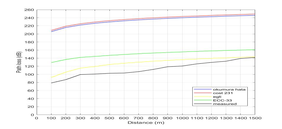
Fig: -5. ComparisonbetweenthemeasuredPathLoss ValuesandthosePredictedbytheempiricalmodels. AsdepictedinFig5,thepathlossmodelsnamely;OkumuraHata,COST231,Egli,andECC-33arecomparedtomeasured pathlossdata.Asthedistanceincreases,allmodelsshowan increasingpathlosstrend,consistentwithsignalattenuation over longer distances. The measured data generally has lower path loss than the Okumura-Hata and COST 231 modelswhichpredictmuchhigherlosses.TheECC-33and Egli models are closer to the measured values, but some discrepancies remain, highlighting variations between theoreticalpredictionsandreal-worldmeasurements.
Furthermore, ANFIS was used in obtaining the path loss values.Table6presentsacomparisonofcalculatedpathloss valuesfromdifferentpropagationmodels(Okumura-Hata, COST-231Hata,Egli,andECC-33)againstANFIS(Adaptive Neuro-Fuzzy Inference System) predictions over varying distancesfrom100mto1500m.
Table -:6. ComparisonbetweenDeveloped,Calculated measuredandPredictedPathLossValues
TheresultsshowthattheOkumura-HataandCOST-231Hata models predict significantly higher path loss compared to the measured values, indicating these models may overestimate loss in certain scenarios. The Egli model, designedforsimplerterrains,producesthelowestpathloss predictions, while ECC-33, suited for higher frequencies, gives intermediate values. The ANFIS predictions closely alignwiththemeasuredpathloss,suggestingitsefficacyin modelling real-world propagation conditions. The total values highlight the accumulated differences across distances, further emphasizing the divergence between empiricalmodelsandactualmeasurements.
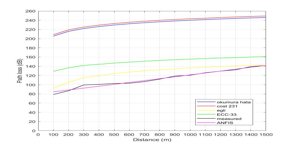
TheplotinFig:-5showstherelationshipbetweenpathloss anddistanceforvariouspropagationmodelsOkumura-Hata COST231,Egli,ECC-33andthenewmodelANFIS(Adaptive Neuro-FuzzyInferenceSystem)alongwithmeasureddata. Asthedistanceincreases,allmodelsindicateagrowingpath lossduetosignalattenuation.Amongthemodels,OkumuraHata and COST 231 predict the highest path losses, significantlydivergingfromthemeasureddata.ECC-33and Egliperformbetterbutstill showdiscrepancieswithrealworldmeasurements.TheANFISmodelcloselyalignswith themeasureddataparticularlyatlargerdistances,indicating itspotentialasamoreaccuratemethodforpredictingpath loss in this scenario. This highlights the advantages of AIbased models like ANFIS for bridging the gap between theoreticalpredictionsandreal-worldmeasurements
ComparisonbetweenDevelopedPathLossModels
Research
Volume: 11 Issue: 12 | Dec 2024 www.irjet.net
Statistical comparison of different propagation models (Okumura-Hata, COST-231 Hata, Egli, ECC-33, and ANFIS) basedontheirperformancemetricsinpredictingpathloss. The metrics include Chi-square Error, Root Mean Square Error(RMSE),CoefficientofDetermination(R²),andMean Absolute Error (MAE). From Table 7, Among the models, Okumura-HataandCOST-231Hataperformtheworst,with high Chi-square errors (938.26 and 974.95, respectively) and low R² values (0.0909 and 0.0904), indicating poor correlation with measured data. The Egli model shows significant improvement, with a much lower Chi-square error (32.21), RMSE (16.30), and a higher R² (0.881), reflectingbetteraccuracy.
The ECC-33 model performs moderately well with a Chisquareerrorof151.66andR²of0.374.However,theANFIS model outperforms all others, exhibiting the lowest Chisquare error (1.25), RMSE (0.32), and MAE (2.026) while achieving the highest R² value (0.976), indicating a very closematchwithmeasureddataandthehighestpredictive accuracy
Table -:7. Statistical comparison of Models.
3.3 Discussion of Result
ThecomparativeanalysispresentedinTable7highlights thesignificantsuperiorityofthedevelopedmodel(ANFIS) overtraditionalempiricalpathlosspredictionmodels.The precision and accuracy of the developed model are particularly remarkable, as evidenced by a substantial reduction in statistical errors compared to conventional modelslikeOkumura-HataandCOST-231Hata.
The developed model demonstrates a high fidelity in its predictions,withaRootMeanSquareError(RMSE)ofonly 0.32145dB,dramaticallyoutperformingtheRMSEvaluesof 120.38dBforOkumura-Hataand123.56dBforCOST-231 Hata. This highlights a significant enhancement in the model'spredictivecapability.
Additionally, the Chi-square error, a critical metric for evaluatingthealignmentbetweenpredictedandobserved values,isreducedtoamere1.252063dBinthedeveloped model. This is a striking improvement compared to the 938.2616 dB and 974.953 dB observed for the OkumuraHataandCOST-231Hatamodels,respectively,underscoring theprecisionachievedthroughitsadaptivetrainingprocess.
TheCoefficientofDetermination(R²)furtheremphasizesthe reliabilityofthedevelopedmodel,achievinganexceptionally highvalueof0.976,instarkcontrasttothelowerR²values of0.0909forOkumura-Hataand0.0904forCOST-231Hata. This indicates a much stronger correlation between the developedmodel'spredictionsandthemeasuredpathloss data, demonstrating its consistency, reliability, and robustnessforreal-worldapplications.
This research presents the development of a Path loss PredictionModelUsinganAdaptiveNeuro-FuzzyInference System for Enhanced Wireless Network Performance OptimizationinUrbanEnvironments.Thisstudyaddresses thepersistentchallengeofaccuratelypredictingpathlossin wireless communication systems, particularly in complex urban environments such as Zaria GRA in Nigeria. Conventional empirical models like Okumura-Hata and COST-231Hataoftenfailtoaccountfortheintricatefactors influencingsignalpropagation,resultinginhigherrorsand poor correlation with measured data. By leveraging the Adaptive Neuro-Fuzzy Inference System (ANFIS), this researchsuccessfullydevelopedarobustandaccuratepath loss prediction model tailored for 4G LTE networks. The ANFISmodelincorporatesadaptivelearningandfuzzylogic principles,enablingittoaccountforcomplexenvironmental andpropagationvariablesmoreeffectivelythantraditional models.Fourwellknowpathlossmodelsnamely;OkumuraHata,COST-231Hata,Egli,andECC-33werecomparedwith the developed Pathloss model (ANFIS) and evaluated in termsofChi-squareerror,RootMeanSquareError(RMSE), CoefficientofDetermination(R²),andMeanAbsoluteError (MAE). Results demonstrate that the ANFIS model outperforms all benchmark models, with an RMSE of 0.32145dB,aChi-squareerrorof1.252063dB,andanR²of 0.976, signifying exceptional predictive accuracy and reliability. These findings establish the ANFIS model as a significantadvancementinpathlossmodelling,providinga precise toolfor optimizing wireless network performance and mitigating challenges like signal degradation, interference, and coverage issues. While the ANFIS model hasprovenhighlyeffectivefor4GLTEpathlosspredictionin urban environments, future research should extend its application to other frequency bands and network generations, such as 5G and beyond. Incorporating additional input variables, such as terrain data, building material characteristics, and dynamic weather conditions, could further enhance the model's predictive capability.
International Research Journal of Engineering and Technology (IRJET) e-ISSN: 2395-0056
Volume: 11 Issue: 12 | Dec 2024 www.irjet.net p-ISSN: 2395-0072
Moreover, the integration of advanced machine learning techniques, such as deep learning and hybrid models combining ANFIS with neural networks or genetic algorithms, could yield even greater accuracy and adaptability
[1] C.Teodorescu,A.Durnoi,andV.Vargas."TheRiseofthe Mobile Internet: Tracing the Evolution of Portable Devices."ProceedingsoftheInternationalConference onBusinessExcellence,2023,vol.17,pp.1645–1654. https://doi.org/10.2478/picbe-2023-0147.
[2] A.R. Mishra. Fundamentals of Network Planning and Optimization2G/3G/4G:Evolutionto5G,2ndedn.Wiley, NewYork,2018.ISBN:9781119331711.
[3] Solyman and K. Yahya. "Evolution of Wireless CommunicationNetworks:From1Gto6GandFuture Perspective." International Journal of Electrical and ComputerEngineering(IJECE),2022,vol.12,pp.3943–3950. https://doi.org/10.11591/ijece.v12i4.pp39433950.
[4] R.Chataut,M.Nankya,andR.Akl."6GNetworksandAI Revolution-ExploringTechnologies,Applications,and Emerging Challenges," 2023. https://doi.org/10.20944/preprints202312.0829.v1.
[5] M. Attaran. "The Impact of 5G on the Evolution of Intelligent Automation and Industry Digitization." J AmbientIntellHumanComput,2023,vol.14,pp.5977–5993.https://doi.org/10.1007/s12652-020-02521-x.
[6] M.Z.Asghar,S.A.Memon,andJ.Hämäläinen."Evolution of Wireless Communication to 6G: Potential ApplicationsandResearchDirections."MDPIJournalof Sustainability, 2022, vol. 14, no. 6356. https://doi.org/10.3390/su14106356.
[7] H.Abdulkareem,A.Tekanyi,A.Kassim,Z.Z.Muhammad, U. Abdu-Aguye, and H.A. Adamu. "Analysis of a GSM NetworkQualityofServiceUsingCallDropRateandCall Setup Success Rate as Performance Indicators." EuropeanJournalofElectricalEngineering,2020,vol.1, pp.113–121.
[8] J. Isabona, E. Oghu, and O. Omasheye. "Path Loss and Models: A Survey and Future Perspective for Wireless Communication Networks." International Journal of AdvancedNetworkingandApplications,2023,vol.15, pp. 5892–5907. https://doi.org/10.35444/IJANA.2023.15209.
[9] E.I. Augustus, L.I. Agbotiname, O.A. Simeon, S.N. John, C.U. Ndujiuba, and E.F. Idachaba. "An Empirical
PropagationModelforPathLossPredictionat2100MHz in a Dense Urban Environment." Indian Journal of ScienceandTechnology,2017,vol.5,no.10,pp.1–9.
[10] Risi, C. Ogbonda, and J. Isabona. "Development and ComparativeAnalysisofPathLossModelsUsingHybrid Wavelet-GeneticAlgorithmApproach."SpringerNature SwitzerlandAG,2023.https://doi.org/10.1007/978-3031-36115-9_45.
[11] S.PhaiboonandP.Phokharatkul."ApplyinganAdaptive Neuro-FuzzyInferenceSystemtoPathLossPrediction in a Ruby Mango Plantation." J. Sens. Actuator Netw., 2023, vol. 12, no. 71. https://doi.org/10.3390/jsan12050071.
[12] G.P.N.Hakim,M.H.Habaebi,S.F.Toha,M.R.Islam,S.H.B. Yusoff, E.Y.T. Adesta, and R. Anzum. "Near Ground PathlossPropagationModelUsingAdaptiveNeuroFuzzy Inference System for Wireless Sensor Network Communication in Forest, Jungle and Open Dirt Road Environments." Sensors, 2022, vol. 22, no. 3267. https://doi.org/10.3390/s22093267
[13] G.GeorgeandJ.Idogho."PathLossPredictionBasedon MachineLearningTechniques:SupportVectorMachine, Artificial Neural Network, and Multilinear Regression Model."OpenJournalofPhysicalScience(OJPS),2022, vol. 3, no. 2, pp. 1–22. https://doi.org/10.52417/ojps.v3i2.393.
[14] N. Faruk, N. Surajudeen-Bakinde, A. Abdulkarim, S. Popoola, A. Abdulkarim, O. Abiodun, and A. Atayero. "ANFISModelforPathLossPredictionintheGSMand WCDMABandsinUrbanArea."ELEKTRIKA-Journalof Electrical Engineering, 2019, vol. 18, pp. 1–10. https://doi.org/10.11113/elektrika.v18n1.140.
[15] S. Ojo. "Development of a Path-Loss Prediction Model Using Adaptive Neuro-Fuzzy Inference System." International Journal of Wireless and Microwave Technologies, 2019, vol. 11, pp. 40–53. https://doi.org/10.5815/ijwmt.2019.06.05.
[16] O.J.FamorijiandT.Shongwe."PathLossPredictionin TropicalRegionsUsingMachineLearningTechniques:A CaseStudy." MDPIElectronics,2022,vol.11,no.2711. https://doi.org/10.3390/electronics11172711.
[17] W.Lina,H.Danping,A.Bo,W.Jian,Q.Hang,G.Ke,andZ. Zhangdui. "Artificial Neural Network-Based Path Loss PredictionforWirelessCommunicationNetwork."IEEE Access, 2020, vol. 8, pp. 199523–199538. https://doi.org/10.1109/ACCESS.2020.3035209.
[18] C.K.Vithanawasam,Y.L.Then,andH.T.Su."Calculation of Data Rates for Varying Scenarios Using Free Space
2024, IRJET | Impact Factor value: 8.315 | ISO 9001:2008
International Research Journal of Engineering and Technology (IRJET) e-ISSN: 2395-0056
Volume: 11 Issue: 12 | Dec 2024 www.irjet.net p-ISSN: 2395-0072
Path Loss and Okumura-Hata Model in the TVWS Frequency Band." IEEE Region 10 Humanitarian Technology Conference (R10-HTC), 2020, December. https://doi.org/10.1109/R10HTC49770.2020.9357022
[19] E.M.D. Eric, B.K. Ivan, T.M. Joel, W. Felix, and T. Emmanuel. "Okumura-Hata Propagation Model Optimization in 400 MHz Band Based on Differential EvolutionAlgorithm:ApplicationtotheCityofBertoua." Journal of Computer and Communications, 2023, vol. 11,no.5.
[20] R.T.Juang."PathLossModellingBasedonPathProfilein Urban Propagation Environments." IET Communications, 2022, vol. 16, pp. 685–694. https://doi.org/10.1049/cmu2.12369.
[21] Z.Nadir,A.L.Hassan,andA.O.Mahmood."Propagation Measurements and Pertinency of Models for CommunicationsSystemsinOman."AmericanJournal ofScienceandEngineering,2020,vol.1,issue4.
[22] J. Akanni, A. Abdurrhaman, O. Ogunbiyi, and B.A. Olufeagba."AModifiedCost-231-HataPathLossModel forTypicalSemi-UrbanEnvironmentsinNigeria."KIU JournalofScienceEngineeringandTechnology,2024, vol. 3, pp. 112–120. https://doi.org/10.59568/KJSET2024-3-1-11.
[23] E.L.Imhomoh,H.C.Madu,R.U.Onuoha,andG.Ogburie. "OptimizationofCost-231HATAModelforPropagation Path Loss Measurements in Lagos." International JournalofEngineeringScienceInvention(IJESI),2021, vol.10,no.3,pp.14–23.
[24] E. Chibuzo. "Determination of a Path-Loss Model for Long Term Evolution (LTE) in Yenagoa." The InternationalJournalofEngineeringandScience(IJES), 2018,vol.7,no.10,pp.38–44.
[25] O.A.Aremu,O.S.Makinde,L.O.A.Oyinkanola,W.A.Azeez, andJ.A.Mufutau."OptimizationofCOST-231HataRadio Propagation Prediction Model for GSM 4G FDD-LTE Operating at 1800 MHz in Tropical Region." Quest JournalofElectronicsandCommunicationEngineering Research,2023,vol.9,no.1,pp.09–16.
[26] T.Mlinar,U.Podgrajšek,andB.Batagelj."Comparisonof Coverage-Prediction Models for Modern Mobile Radio Networks." MDPI Electronics, 2023, vol. 12, no. 4554. https://doi.org/10.3390/electronics12224554
[27] Perpetual,A.Ekanem,andN.Aloziem."Comparisonof PathLossPredictionPerformanceofEgliModelandLee ModelforCellularNetworkSignalAlongaDualCarriage WayinUyo."ScienceandTechnologyPublishing(SCI&
TECH), 2019, vol. 3, no. 9. https://doi.org/10.13140/RG.2.2.10711.62882.
[28] O.A.AremuandN.O.Anie."ValidationofEgliModeland EstimationofPathLossExponentofaRadioSignalat VHF Band in Hilly Terrain." International Journal of Research and Innovation in Applied Science (IJRIAS), 2020,vol.V,issueIX,pp.95–100.
[29] S.Ojo,T.Ojo,andV.Etta."AFuzzy-Logic-BasedPathLoss Model at 3.4 GHz for LTE Networks." Open Journal of Applied Sciences, 2022, vol. 12, pp. 1271–1283. https://doi.org/10.4236/ojapps.2022.127087.
[30] E.O. Ifesinachi, V.E. Idigo, C.O. Ohaneme, and P.C. Obioma. "Development of an Empirical Propagation PathLossModelforanLTENetworkinOnitsha,SouthEastern Nigeria." Journal of Engineering and Applied Sciences,2021,vol.19,no.1,pp.474–484.
[31] Mohammad and A. Sameer. "Application of Adaptive Neuro-Fuzzy Inference System in Modelling HomeBasedTripGeneration."AinShamsEngineeringJournal, 2023, vol. 14, no. 11. https://doi.org/10.1016/j.asej.2023.102523.
[32] BuriboevandA.Muminov."ComputerStateEvaluation UsingAdaptiveNeuro-FuzzyInferenceSystems."MDPI Sensors, 2022, vol. 22, no. 9502. https://doi.org/10.3390/s22239502.
[33] L.Xu,C.Huang,R.Su,H.Zhu,H.Liu,Y.Liu,C.Li,andJ. Wang. "Estimation of Tool Life and Cutting Burr in High-SpeedMillingoftheCompactedGraphiteIronby DE-Based Adaptive Neuro-Fuzzy Inference System." Mechanical Sciences, 2019, vol. 10, pp. 243–254. https://doi.org/10.5194/ms-10-243-2019
[34] Ramadan,S.Kamel,I.Hamdan,andA.M.Agwa."ANovel IntelligentANFISfortheDynamicModelofPhotovoltaic Systems." Mathematics, 2022, vol. 10, no. 1286. https://doi.org/10.3390/math10081286.
[35] M.K. Elmezughi, O. Salih, T.J. Afullo, and K.J. Duffy. "Comparative Analysis of Major Machine-LearningBasedPathLossModelsforEnclosedIndoorChannels." Sensors, 2022, vol. 22, no. 13, p. 4967. https://doi.org/10.3390/s22134967.
[36] K.J. Jang, S.J. Park, J. Kim, Y.K. Yoon, C.S. Kim, and Y.J. Chong. "Path Loss Model Based on Machine Learning UsingMulti-DimensionalGaussianProcessRegression." IEEE Access, 2022, vol. 10, pp. 115061–115073. https://doi.org/10.1109/ACCESS.2022.3217912.
[37] B.M. Rashed and N. Popescu. "Medical Image-Based Diagnosis Using a Hybrid Adaptive Neuro-Fuzzy Inferences System (ANFIS) Optimized by GA with a Deep Network Model for Features Extraction." MDPI
International Research Journal of Engineering and Technology (IRJET) e-ISSN: 2395-0056
Volume: 11 Issue: 12 | Dec 2024 www.irjet.net p-ISSN: 2395-0072
Mathematics, 2024, vol. 12, no. 5, p. 633. https://doi.org/10.3390/math12050633.
[38] A.A.Mohamad,T.A.Ahmad,L.A.Mohd,I.Norulhuda,and A.A. Salmi. "Adaptive Neuro-Fuzzy Inference System (ANFIS)FormulationtoPredictStudents'Neuroscience Mechanistic: A Concept of an Intelligent Model to Enhance Mathematics Learning Ability." TEM Journal, 2022, vol. 11, no. 4, pp. 1942–1951. https://doi.org/10.18421/TEM114-63
© 2024, IRJET | Impact Factor value: 8.315 | ISO 9001:2008 Certified Journal | Page439