JASON KEITH URBAN
PORTFOLIO
PLANNING

University of Cincinnati, Cincinnati, OH
Anticipated Graduation: May 2024
Bachelor of Urban Planning / GPA: 3.97
Dean’s List (2019-2022)
Cincinnatus Scholar
Member of the UC Army Reserve Officer Training Corps (ROTC)
Participating in the Professional Practice Program, alternating semesters of classroom study with work in the field of planning.
West Clermont High School, Batavia, OH
August 2015 - May 2019
Honors Diploma / GPA: 4.46 / Rank: 9
Army ROTC
• Co-Captain of Ranger Challenge Team
• Battalion S3 Fall 2023
• Recipient of Leadership and Academic Achievement Award from the Association of the United States Army
DAAP Tribunal
• Member 2021-Present
• Senate Representative Spring 2022 and Summer 2023
Microsoft Office
Illustrator InDesign
Photoshop
Acrobat
AutoCAD Civil 3D
Sketchup/V-Ray
ArcGIS/ArcMap
Transportation Planning/Engineering Intern
AECOM, Cincinnati, OH
January 2023 - Present
• Served as project intern working with the Cincinnati and Cleveland Transportation departments involved in multiple local and statewide transit projects.
• Assisted in 30% Design for Columbus Transit Authority West Main and East Broad High Capacity Transit Corridors, involving design of roadway ingress/egress replacements, designing pedestrian infrastructure, and analyzing necessary removal and property acquisition.
Transportation/Transit Planner Intern
AECOM, Los Angeles, CA
May 2022 - July 2022
• Served as a project intern for the Transportation/Rail department involved in multiple local and regional transit projects.
• Reviewed and revised the Draft Environmental Impact Report for LA Metro Eastside Transit Corridor Phase II.
• Provided research for the creation of AzDOT Electric Fleet Conversion Study involving creation of an existing and future conditions report.
• Assisted in the creation of the Draft Environmental Impact Report for LA Aerial Rapid Transit.
McBride Dale Clarion, Cincinnati, OH
August 2021 - December 2021
• Consulted clients through the entitlements phase of development, including receiving approvals for projects and attending meetings.
• Responsible for researching project background including evaluating current zoning regulations, necessary variance proceedings, and making submittals for clients.
Union Township Planning and Zoning, Cincinnati, OH
June 2020 - August 2021
• Executed administrative tasks including accepting/filing zoning permits and executing planning and zoning review for new projects.
• Communicated with community about questions/concerns pertaining to property limitations and project insight.
• Assist in legal proceedings for project variances and township trustee meetings.

Site Planning: English Woods


My work with AECOM has encompassed Transit Planning and Engineering on various projects including heavy rail transit, light rail, bus rapid transit, electric vehicle planning, bike trails, and other multi-modal transportation projects. I have included a brief description of my time at both offices and some samples of work I have completed while there.


My most recent co-op with AECOM was in their Cincinnati, OH office, working with the Transportation Department on transportation planning engineering projects largely encompassed within the City of Cincinnati and State of Ohio.
Throughout this experience I was tasked with creating and reviewing technical engineering drawings for transit and roadway projects. Much of my time was spent working on the East Main and West Broad Bus Rapid Transit lines, where I contributed to technical analysis of land acquisitions, drafting public and private ingress/egress, and bringing the pedestrian and automobile infrastructure on the road up to standard code.
LinkUS is a massive transit initiative for Central Ohio being lead by the City of Columbus, COTA, Franklin County and the Mid-Ohio Regional Planning Commission, as well as numerous other local governments. The intent is to expand public transportation services and options including the creation of sidewalks, bikeways, and high capacity transit service to encourage equitable growth

 Image sourced from LinkUS Community Action Plan, 2023
Driveway and Curb Design, East-Main BRT
Driveway Design, East-Main BRT
Roadway Removals, East-Main BRT
My first co-op with AECOM was in their Los Angeles, CA office, working with the Transportation Department on transportation planning projects largely encompassed within the City and County of Los Angeles.
This opportunity presented me with the ability to work in a sector of planning I had little professional experience in, work with a large company known for its groundbreaking projects worldwide, and the chance to work in a global city like Los Angeles. Projects involved working with Los Angeles Metro, who serves a population of more than 10 million in a service area over 1,400 square miles.
All statistical information and images sourced from metro.net
DTLA Long Beach Hollywood Sant a Monica Whittier
Project Description:
The Crenshaw Northern Extension would be a northern continuation of the Crenshaw/ LAX light rail line, traveling entirely sub-grade, to the base of the Hollywood Hills.
The project currently has three proposed alignments, all of which would connect to multiple existing and proposed rail and bus lines.


Individual Contribution:


Project Description:
The LA ART system would connect Los Angeles Union Station to Dodger Stadium via an aerial gondola system, reducing traffic during game times primarily and providing another mobility option for fans and residents of the neighborhoods surrounding it.
The project is quoted to provide a 6-7 minute one way trip and maximum capacity of 5,500 passengers an hour.
Project Description:
Metro plans to create an eastern extension of the L-Line (Gold) from its current terminus with three alternative options, the furthest of which would take the line 4.6 miles to the City of Whittier.
The full extension would serve the cities of Commerce, Montebello, Pico Rivera, Santa Fe Springs, Whittier and the unincorporated area of East LA and Los Nietos-Whittier.
Individual Contribution:


Individual Contribution:
Our goal was to create greater access to the Mill Creek and around the Mill Creek within our focus district. The vision was to create a destination and a point of connection between the neighborhood it intersects by means of mobility via the creation of a greenway and blueway system. This system will provide visitors with access to a waterway, nature, ecology, and passive/ active recreation.


The Mill Creek is a lesser known waterway of the greater Cincinnati area due to its lack of access causing underutilization. Being used for years as an industrial runoff outlet and becoming known as one of the worse polluted waterways in the country, the Mill Creek has regained attention for its restoration efforts.
Today, the Mill Creek is in need of a regional plan to redevelop the area for the people and businesses that surround it, a plan to create greater access and utilization of Cincinnati’s urban waterway.


Early settlements used the creek for movement of goods and people, today railroads, highways and trails line the creek’s banks.

With the rise of Industrialization, the creek gave life and power to many emerging businesses in the City. This use would eventually turn to overuse though and lead to many problems the creek has faced.

Recent years the Creek has created a barrier for the communities it lines, much of its natural features stripped and channelized for efficiency purposes.

Research Objectives
One large overarching objective the group took focus on was the completion of an existing Mill Creek Bike Path. The goal became not only to finish the trail throughout the district, but to improve its current condition, create a better environment for users, and to extend its boundaries along the banks of the Creek and add in new green infrastructure to turn this pathway into the Mill Creek Greenway.
Many of the improvements needed to create change and better access in the district have been noted on the illustrative plan to the right.

To achieve our goals and objectives set forth at the beginning of the planning process, we devised a series of strategies for change. These physical changes to the district are categorized by their cost, installation timeline, longevity of the project and the disruption is would cause to current access and mobility.


Impact


Impact


Graphic created Nicholas Heaton

Graphic created Brandon Williams
We decided on five broad implementation strategies for creating better access to the Mill Creek. Due to collaboration constraints and feedback, the implementation strategies will become more focused as the planning process commences.


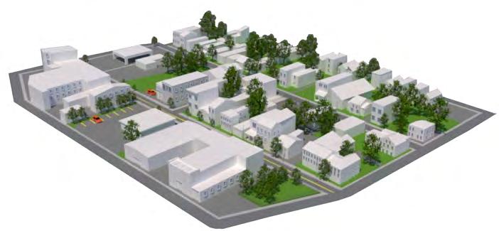
Tasked with developing a site in a West Side neighborhood of Cincinnati, almost entirely vacant and publicly owned. Goal was to create a more sustainable and diverse mix of land uses to support the redeveloping area.


A temporary community of the past, pushing for a promising plan in the future
The neighborhood of English Woods began as a temporary housing project of the 1940s, its temporary status however grew into a permanent settlement. In recent years, it has been subject to demolition due to neglect and is now looking for a plan for the future that will provide sustainable living for the Mill Creek Community.
1

An overarching goal from the beginning of the analysis was to fix the lack of housing and housing diversity in the area.
With only one through street in the neighborhood, improving how cars and pedestrians would move was a large focus in this analysis.
The community surrounding English Woods faces many problems such as lack of basic needs and resources, so the new neighborhood needed to serve more than just its residents.
Only two main entryways with one through street

Sutter View: most recent housing project; renovations in 2020
Large Tree Canopy Marquette Manor: senior housing projectSpace
The conceptual plan for English woods focuses on improving connectivity by establishing new roads, diversifying land uses to create more activity and a greater mix of living options, and aims to retain the neighborhoods hilltop appeal.
Living


What resulted from much research, design and revision was a new English Woods made for the community. An emphasis on resources and diversified land uses help make the English Woods more adaptable and created an asset for the community. The West Side of Cincinnati has gone through many changes, the changes made for English Woods hope to rebuild a lost community and help existing residents find stable housing. Many project housing developments create cold spaces, this development offers a new look at how large housing developments can intertwine with the community and become a place residents want to live, not forced to live.
• Promotes Walkabilty
• Traffic Calming
• Active Street Level
• Introduce Roundabouts
• Limit Cul-de-sacs
• Large Trail Network
• Public Park
• Community Resource
• Retain Natural Hillside
• Enhance Mobility
• Retain Natural Topography
• Facilitate Development Phasing
• Better Connection
English Woods Commercial District may just be it’s most unique and ambitious aspect. Unlike much of its surroundings, this high density commercial district was made to accommodate for the needs that this isolated site has while also providing community wide assets. Offering a large amount of 1, 2, & 3 bedroom apartments, ground level retail, parking garages, a grocery store, dedicated bus station and a community center. Wide sidewalks and 4 lanes of road allow for all the circulation of traffic that will eventually fill this vibrant neighborhood center.

174

Commercial District Tools: Illustrator, Photoshop
 Grocery Store, Apartments and Community Center surrounding Roundabout
New Dedicated Bus Station
Grocery Store, Apartments and Community Center surrounding Roundabout
New Dedicated Bus Station
The multi-family/single-family residential district focused on here was designed to be dense and promote walking through the neighborhood not driving past it. The roadway network in this area is largely meant to limit driving unless necessary. Parking has been concealed as much as possible to limits the large setbacks that they usually require. The area was meant to resemble development of the past, in traditional garden cities.


The proximity of assisted living to the senior landominiums was no coincidence but rather a thought out way to allow access for emergency services to the independent living if necessary. The large assisted living complex allows for 32 units of assisted living, an on site parking garage and a green roof implemented for aesthetics and to reduce cooling needs. This space is truly unique not only to the site but to the surrounding area as a dedicated space for Cincinnati’s aging residents.

112
Total Units Assisted Independent 80 32

Senior Living Landominiums Tools: Illustrator, Photoshop

In collaboration with another planning student, we conducted a semester long study into the Mill Creek neighborhood of Camp Washington. We analyzed the neighborhood to learn about the past of the, its rise to prominence, its eventual decline, the present day state, and provided a number of ways to help improve its current state.
Inset Map: Camp Washington
Tools: ArcMap, CAGIS2015
To better understand the current state of Camp Washington, it was essential to us to create visualizations of the current capacity for change (building footprint map), how the neighborhood was traversed (linkages map), and how we felt these two combined to create the current state of the neighborhood and what areas were unique (imageability map).
Building Inventory Tools: ArcMap, CAGIS2015
Land Use Tools: ArcMap, CAGIS2015
Linkages Tools: ArcMap, CAGIS2015

Imageability Tools: Illustrator, Pen/Pencil

Camp Washington’s industrial heritage and heavy population density at one time created a mixed-use environment within much of the neighborhood. With lack of space due to large industrial buildings many homes and businesses crowded along the other valuable pieces of land. Analyzing the mixed use typology of the neighborhood helped us understand what the neighborhood’s capacity for redevelopment would be.


Tools: SketchUp, V-Ray, On the Map
Colerain Ave Elevation
Tools: Illustrator
Contact
Mobile: +1(513)787-9681 E-Mail: keithja@mail.uc.edu
LinkedIn: linkedin.com/in/jason-keith-734394198
