
Portfolio
JASON CHUN-CHENG YEH
Selected Works 2019-2025


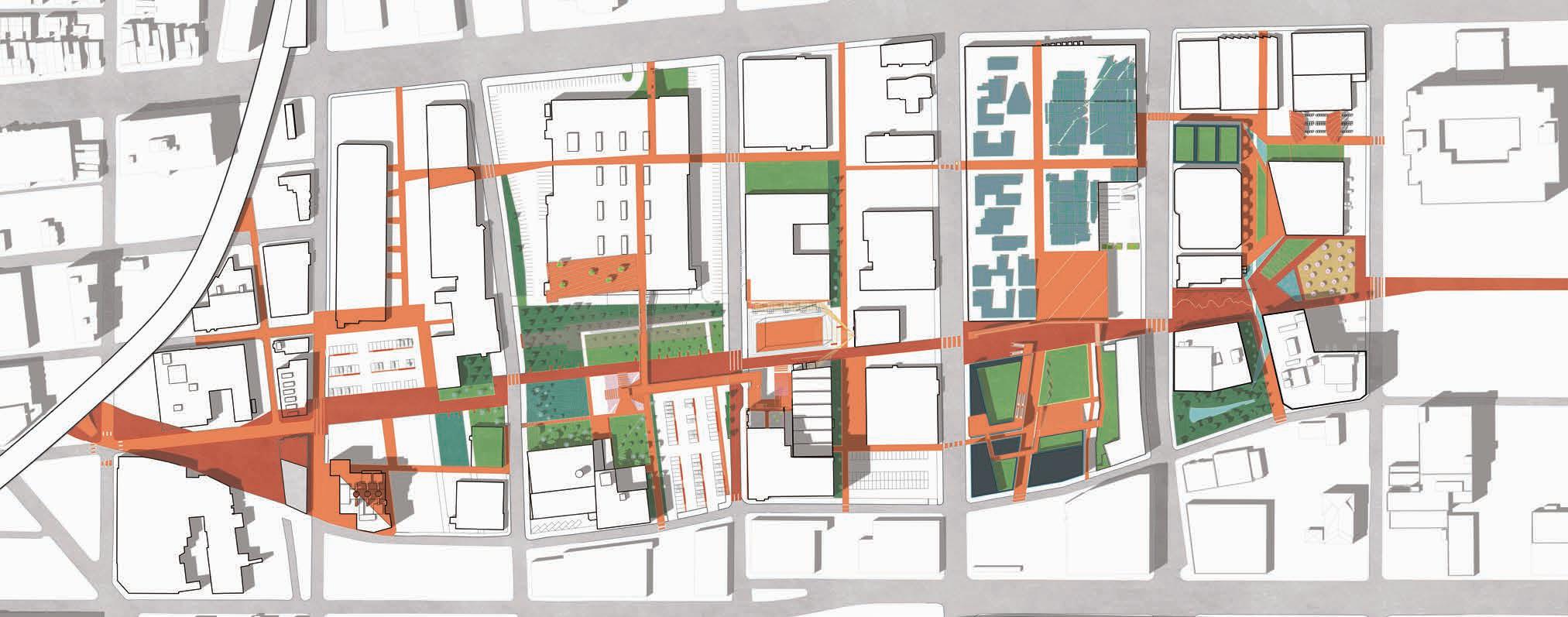
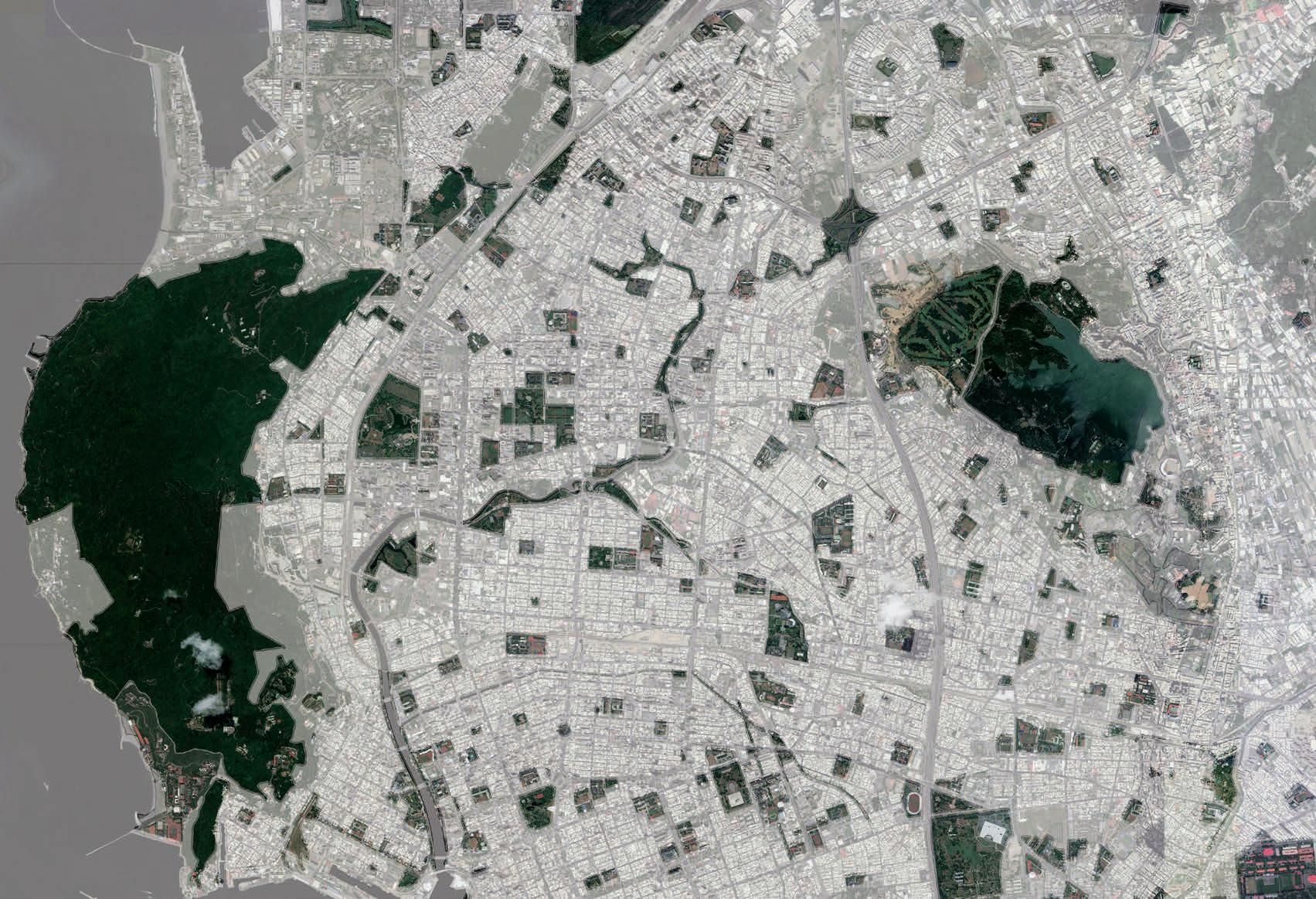
City Green Gate 01
Site/ Hsinchu City, Taiwan (2021~2023)
Role/ Project Architect, Construction Supervisor
Contribution/ SD & DD & CD & CA, Construction Supervision
Supervisor/ Sheng-Yuan Huang(Principal), Huang-Shie-Yao Liu(CEO), Chih-Chung Yang(Construction Manager)
Award/ Top 10 Exemplary Projects by Taiwan's Ministry of the Interior (completion, 2024)
Tear down the walls to see green forests
The City Green Gate project, in which I did most of the design and was responsible for on-site construction supervision, aims to reorganize disarrayed surroundings and recover the urban environment with an ecological landscape and simple structures.
Intersections between institutes, campuses, and the city become a welcoming landscape with undulating hills, flood detention areas, public plazas, and elegant public facilities.
Redefine city gate with a 1-mile sequences of public spaces

Towards a Walkable City: The City Green Gate as regional engine
The project was granted by Central Government, and executed by the Hsinchu City Government (HCG) with the collaboration of several land management units, such as the National Tsing Hua University (NTHU), the Industrial Technology Research Institute (ITRI), and the Professional Training Center of Ministry of Economic Affairs (MOEA).
By connecting urban nodes with existing water or public campuses, the network for roaming citizens and migrating animals may spread outward to the once-abandoned areas, the college town, the residential area on the east side of the National Highway, and the fields nearby Touquian River.


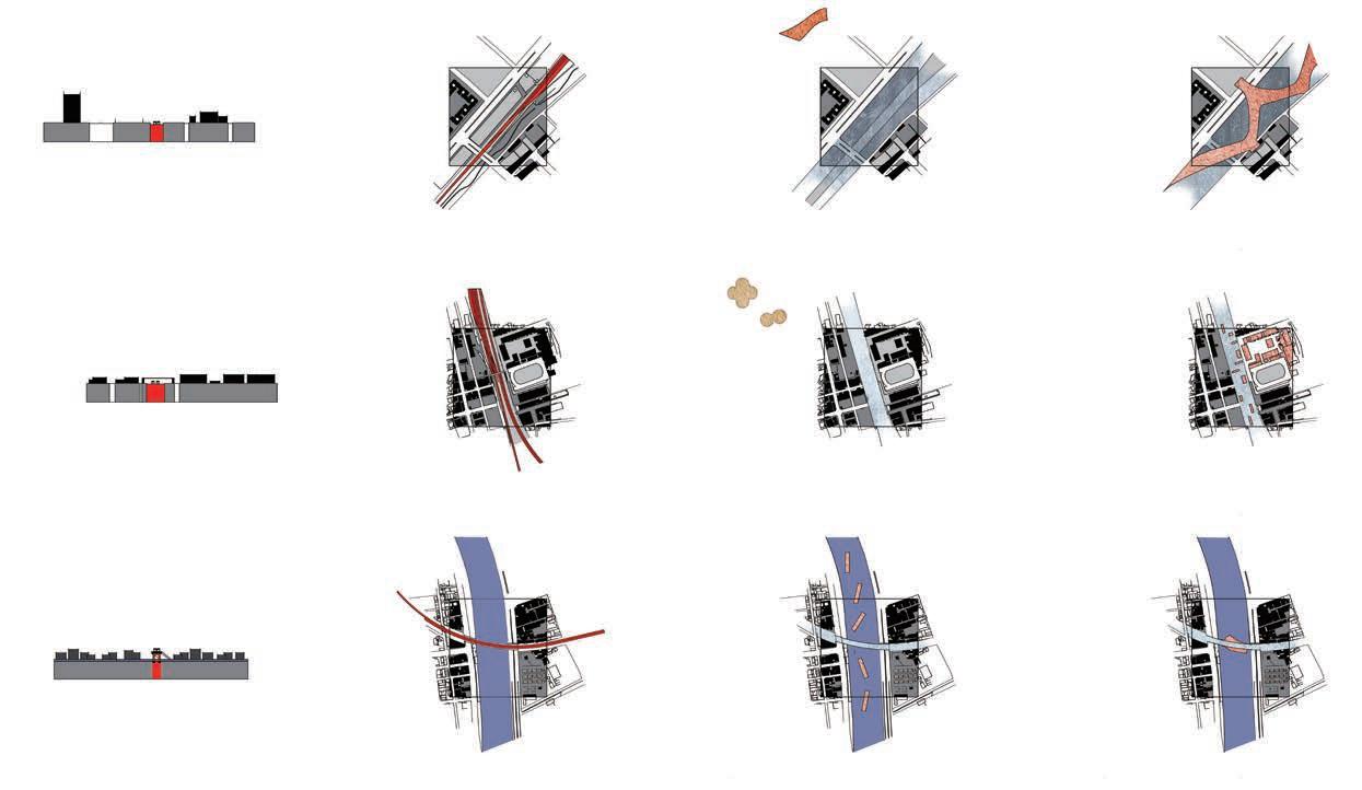
Deconstruction Plan
Drainage+Planting Plan
Paving+Furniture Plan
Detail Section
Landscape Detail
Long Distance Bus Station
City Bus Station
Renovated Bus Station
Renovated Entrance Booth
Structural Design
Structural Design -
Elevated Paving System
Lighting Design
The Integration and Collaborative Process of Constructions
As the project architect and construction supervisor, I am fully responsible for on-site design adjustments and coordination with multiple design teams, consultants, and stakeholders. Despite the pressure, I enjoyed the beauty of making decisions and hearing different voices.

Reconnect the onceenclosed university to urban environment The intersection between the NTHU campus and the city used to be a 500-motor parking area, a 200-bike parking area, a post office, and the campus's north gateway. Through series of negotiation, the university agreed to move these facilities to the inner parts of the campus. Since then, the physical boundary of land property had gradually vanished. This vital junction suddenly becomes a public welcoming landscape with undulating hills and plazas. Most important of all, none of the 143 old trees within the site is sacrificed
B]


Fragment plan/ With the reconfiguration of "served" and "be-served" facilities, the site becomes a much welcoming combination of flood detention landscape, plazas, and refurbished public facilities.


3 Zones to Design Urbanscapes, from Model to Local Craftsmanship
The main 3 zones slightly transition the spatial experiences and materiality from historical campus entry to the modern bus stations. The large 1/100 model (size: 4x13') I made accompanied me from the detailed design stage to the construction site, gradually turning the imagination of multi-dimensional spatial experience into reality in thousands of discussions with workers.
1/100 Design Model/photo by Minjia Chen Night Views/ photo by Mayor Chichien Lin
[Zone A] campus entry plaza
[Zone B] boulevard of campus life, city bus station
[Zone C] long distance bus station


[Zone A] Campus gate as a vital and historical urban node of the city
The campus gate of National Tsing Hua University, designed by renowned sculptor Ying-Fung Yang in 1977, once radiated elegance and scholarly charm. Over time, motor traffic and shrubs fragmented the area, hindering access.
Through reorganization and material recycling, the plaza now offers safe, open pathways, a scenic forest view, and renewed historical pride for the university and city.

[1950]
[1977]
[2020]


[Zone B] Bus station as both the meeting and anchoring point of the once-fragmented urban space
The road was widened 1.5m and the once fragmented environment was integrated into a continual public spatial sequence. The undulating grass hills prevent floods and create tranquility within the bustling city. The canopy skyline also resembles elegant structures in the campus.
Site condition in 2021.6/ fragmented urban space divided by walls, bulletin board, and flyover bridge
Campus Gym, 1970-/ sufficient yet elegant folding plate structure
[Zone B] A "Boulevard" from university library to night market
After the relocation of the motor parking area, the intersection between campus and the city transformed into a public plaza, undulating grass hills, and the Boulevard of Campus Life. The 2 retaining walls ensure the existed old trees' roots height, remind pedestrians of the decending stairs, and act as horizontal references in an undulating terrain.


[Zone C] An absolute horizontal skyline that unveils a serious of public space
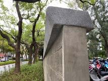
The bus station canopy elegant, absolute horizontal skyline corresponds to the university's rational style and slightly sloping site topography. The bamboo raw concrete also reminds people of Hsinchu City's ancient defensive landscape.

Material and Tectonic System: Interpretations of Locality
During the construction phase, we tend to merge the existing and the newly implanted material, to create a rather familiar and timeless atmosphere
The layout sorts materials with parameters such as "height", "water permeability", and "nostalgia", to compare the initial attempts of the design and the outcome.
After several visits after the completion, I observed that the old and new materials blended and rejoined smoothly on site.
While creating a public welcoming urban space, it is more exciting to create a sense of "familiar unfamiliarity" by making the unseen be seen , which is what I have been striving for, the new interpretations of the locality.


Playground and bike route alongside Yilan River Bank
Site/ Yilan City, Taiwan (constructed, 2019-2020)
Role/ Project Architect
Contribution/ SD & DD & CD Documentation
Team Member/ Han-Hsun Tsai(CD), Shen-Ju Chen(Construction Supervisor)
Supervisor/ Sheng-Yuan Huang(Principal), Huang-Shie-Yao Liu(CEO), Chih-Chung Yang(Construction Manager)
Reshape the dike from a barrier to a playful landscape
The dike built alongside the Yilan River in 1901 stopped seasonal flood and turned Yilan City into a habitable farming wonderland. By reshaping and distorting the dike, the project aims to build a continual public spatial sequence from a wooden monumental platform of the dike's builder, several lookouts and bike stops, to a playground that merges manmade and natural riverside landscapes together.
In-Between/ the playful landform that bridges human activities, river system, and mountain view.

Materials that reflect macro environment and playful activities
As the river joins and turns toward the sea, the dikelike landform covered with pebble stones protects the playground from the flood, yet ensure silver grasses' growth, forms a protective yet penetrable landscape. The enclosed playground with synthetic rubber and terazzo paving shapes a soft and safe area in the middle of the grassland. The shade provided by the viaduct marks the resting area with weather protection. The stele monument on the concrete dike was constructed for commemorating the embankment. The ironwood platform and basalt stairs define the monumental and timeless area, also downscale the existed massive concrete dike to human level.


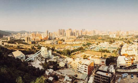
From Industrial Remnants to Awe-inspiring Energy Landscapes
Site/ Northampton, PA, USA (2024)
Area/ 370 acre
Instructor/ Todd Montgomery (MontgomeryT@andropogon.com)
Publication/ "Cement Age/Concrete Nation" Symposium, Kleinman Energy Forum, Fisher Fine Arts Library, University of Pennsylvania
Alternative Future on the Land Scars
The Lehigh Valley, historically exploited for its mineral wealth, bears the scars of industrial extraction. A succession of extractive industries, from slate to coal, hints at a looming decline. In response, I advocate for repurposing quarries near power substations, over 300ft deep, for clean energy storage using gravity bricks. Simultaneously, repurposed railroads would form a network of recycle industrial wastes and bike paths, linking industrial hubs and metropolitans to pave ways for a more economically vibrant future in the Lehigh Valley.
"Wastes Within" "Connected Void" "Layering" "Flexible Intrusion"


Gravity in the Mine: A Clean and Elegant Way for Future Energy Storage
The gravity battery is a block weighing 35 metric tons and made with compressed industrial wastes. By utilizing the depth of the existing quarries, the blocks can store the gravitational energy.
In the daytime, clean energy sources such as solar, hydro, and wind power provide electricity to raise these blocks, and at night, when the energy becomes more expensive, the blocks are dropped and the potential energy is released and turned back into the power grid to everyone's house.
These modern technologies have been put into practice in the Swiss and China. At Northampton, the building-like unit is suggested for its efficiency, compared to the crane-like unit. I've made several calculations that combining the selected unit with solar energy, we can generate electricity equivalent to some of the tratidiontal generating Company, such as the Northampton Generating Company, in a much cleaner and elegant way.

Lehigh Valley: Alternative Future on the Land Scars
I advocate for repurposing vacant quarries near power substations in Lehigh Valley, over 300ft deep, for clean energy storage by inserting the emerging gravity battery system.
Simultaneously, repurposed railroads would form a network of recycled industrial wastes and bike paths, linking industrial hubs and metropolitan areas to pave the way for a cleaner and economically vibrant future in the Lehigh Valley.


The Cement Belt: Utilizing Quarries With Their Unique Potentials Date back to the 1700s, the site was a camp where Willam Penn's Sons stay for the notorious Walking Purchase, following the Lehigh River's direction. In 1971, the Cement Belt and Atlas Cement Co. were at their peak of production. Not only do they provide most of the cement in the US, but they also export to the worldwide.
In my regional proposal in 2045, the Cement Belt in Lehigh Valley, the Atlas Quarry #4 is going to be used as the new energy core, and other quarries can perform their duties altogether. Wastes collected from the region will be compressed as gravity battery blocks and be stored at the Atlas Quarry #4 for energy production. Neighboring industrial zone manufactures products with clean energy and distributes to the western quarries, where public recreation and education usages are the main focus. The retention quarry lake prevents seasonal floods with integration of the existed Ironton Rail Trail.
The Walking Purchase in 1737 was

The Atlas Quarry #4 Neighborhood: Multifaceted Reorganizations
Energy and manufacturing processes will be developed based on existing resources, such as using prefab concrete for framing, and the Material Recycle Station to help collect wastes in the Valley. Ecologically, the Hokendauqua Creek is the spine of various water bodies, such as additional shalow wetlands after sediment removal.
For education and recreation, the school complex and daycare centers can help establish a community-friendly network and unveil the energy "machine". After the first phase of grading, the quarry amphitheater can be used for the graduation ceremony!


Site A: the Quarry
Site B: the Complex


Interwoven Trails, Educational Workshops, Repurposed Artifacts, and Habitats
To utilize the existing industrial and ecological contexts, an "interweaving" spatial strategy is proposed.
The Hokendauqua Creek, as the central blue spine, has long been interrupted with the Atlas Dam and resulted in the legacy sediment issue. In the T3-land remediation phase, the sediments will be regraded into the Quarry Amphitheatre, the creek's sharp turn will be expanded to form multiple shallow wetland habitats and let the water flow into the Lehigh River with appropriate speed.
Alternative usages are applied to the old and new industries, such as the Atlas Dam be fragmented as a stepping path, and the gravity blocks be used as street furnitures.
The trails embracing the industrial complex can both connect to the existing routes, the school's walking network, and even penetrate through the Cement Silo on the elevated path.


The Energy Vista
The Energy Vista consists of the underground museum, amphitheater, gravity battery frame, and a series of cooling ponds, which exchange water with the neighboring Atlas quarry lake.Various plant species have been selected for land remediation for the high CaCO3 tolerances and limestone prairie potentials. Outside the quarry area, the educational workshops and facilities are integrated on an elevated path, which takes people inside the Cement Silo to see the manufacturing process of gravity blocks, the production from regional industrial wastes.


Inside the Cement Silos
A young couple from Northampton Elementary School finally gets to reach the neighboring cement silos to see the manufacturing process of the gravity battery blocks. The blocks are mwade by industrial wastes from the valley and compressed within the factory to contribute to future energy storage.

Tactics of reframing public perception
Site/ Philadelphia, PA, USA (2024)
Area/ 57 acre
Role/ Designer
Team Member/ Xinyun Xie
Instructor/ Christopher Marcinkoski (marcinko@design.upenn.edu)
How to temporarily develop the undeveloped, before future permanent development?
Re-block: re-organize and break down the superblocks for future CMX (commercial mixed-use) development
Goal: to reframe people's perception, including both governors, developers, and citizens
Vibe: economic, temporary, fun, and artistic
Method: to develop public realms first that allows flexibility in investment stages
Program: to unveil site-specific features, define development parcels, and influence future public programmings
An obsolete urban (once-) industrial island
The site, located in Callowhill neighborhood, used to be a vibrant working class neighborhood with fine grain urban fabric.
In the 1950s, the government decided to wipe out the fine grains to develop SUPERBLOCKS to invite industrial investments, and eventually failed.


By overlapping the historical footprints on top of the current footprint, the linear voids from 2 historical street fabrics hint the new clues for future patterns of public realms - linear breakthroughs to scale down the superblocks.
The failed industrial district also left behind buildings with diverse functions and programs, although being confined indoors by the overwhelming massive parking lots.


Form + Function = Re-block Party's Framework!
The elements of the "party"'s framework seem to be playful and random, but in fact they are full of logical synthesis of the site's history, context, and land use regulations.


Stages 1~4: Every phase of urban transformation is worth public participation
The 6 blocks are divided into 4 groups/stages to show different scenarios of investment and development.
Stage 1: Orange paints to hint out parcels and public routes
Stage 2 : Temporary structures to unveil existing buildings' functions
Stage 3: Permanent landscapes and vegetations to replace imperveous and useless parking lots
Stage 4: Developments react to and integrate the public programs


· School of Rock (music)

· ARC Document (paint)
· Guatemala Consulate (Maya civilization)
· Arch Sewing Machine Co (tranpoline)
· Cooper Electric (lights)
Maya pyramid
Light x Sound Palms
Yoga Terrace
Drive-in theater
Quaker projection
rock-n-roll
Meditation Forest
Red Stone Boulevard
Forest Trampoline
The Steam Wall Market
· Redcross (healing landscape)
· Johnson HVAC Supply (ventilation)
· former Quaker Assembly
· Franklin Music Hall (stage)
· Obie Records (records)


[Section AA’] As the steam coming out from “The Wall”, you know Franklin Music Hall is putting on the show!
Visitor Scenario: Enjoy the performance with lights and sound at various heights
The vivid murals and orange path welcome you at the bus stop. What's more, you can walk under the undulating lighting strings that symbolize the music flow and enjoy the mist spraying out from the bent wall provided by the local heating supplier. You can also take the stairs up to the flyover bridges, platforms, all the way to the rooftop Music Terrace of the Franklin Music Hall to enjoy the show. Drinks are provided!

[Section AA’] The once-fragmented and disconnected building entries and terraces are integrated into a marvelous public structure! We can finally enjoy the city view at all heights... [Section


Coming across from
Office Staff Scenario: Outdoor lunches, dramatic structures, and greenspaces for meditation
As a staff of the Guatemala Consulate Office, you might want to take a walk outside during lunch time to the forest or sit on the Maya pyramid and chill out with your colleagues. From the Pyramid, you can take the floating stairs to the meditation roof garden on top of the Red Cross or simply just lie down on the Forest Trampolines.
[Section AA’] The once-fragmented and disconnected building entries and terraces are integrated into a marvelous public structure! We can finally enjoy the city view at all heights...

[Section BB’] Coming across from the N 7th St., you may experience a sound/light show performed by the fake flashy palm trees; from the N 8th St. car entry, the drive-in theatre cinema is about to start!


or drive here to enjoy the outdoor movies
Before the construction starts, why not utilize the huge facade and scaffolds across the street to transform the parking lot into a Drive-in Theatre? As the lighting and electricity companies donate the fake palms with subtle lights and sound, you may enjoy your afterhours strolling on the loop path, climbing onto the Maya Pyramid, and watch your favorite films with your neighbors at those pleasant Friday nights...
Resident Scenario: Walk
N7 St
Forest (w/ fake palms)
Sound Forest (w/ fake palms)
Drive-in Theatre Path N8 St and walkways
Music Terrace
The Confluence
An eco-capital tourism fiction to reshape human-environment relationship

Site/ Shkoder, Albania (2024)
Area/ 48 acre
Team Member/ Athena Yinching Lee
Instructor/ Nicholas Jabs (jabs@porturbanism.com), Meghan Talarowski (meghan@studioludo.org)
To Form a Circular Tourist Economy
As a young country, Albania's high degree of openness to tourism has posed a significant threat to the environment. This fictional "Confluence Park" challenges traditional consumptive tourism by encouraging active participation in creative and rewarding environmental activities. Guests are invited to plant wetland species and restore fish habitats through innovative, game-like experiences, earn digital credits and redeem them within the tourist zone, to create a circular economy that benefits the community.
Rewarding Plays x Environment Restorations
5 Major Issues: Dumping Trash, Deteriorating Wetland, Informal Settlement, Congested Transportation, Declining Local Crafts.
5 Playful Solutions: Trash to Treasure Hunt, Wetland Makeover Show, Squad Build-a-Dream, Zero-Carbon Express, Craft Carnivals for All.
Fun, educational and even satirical environmental activities were invented with responding credits. While the country is embracing capitalism, being eco-friendly is necessary to establish a sustainable economy. Emotionally, our environment is where we become familiar with, respect, and cherish...


Eco-capitalism Tousist Model
Traditional Tousist Model


Site/ Kaohsiung City, Taiwan (2019)
Instructor/ Chen-Luen Hsueh (clhsueh@mail.ncku.edu.tw / (+886)6-2757575#54109)
Awards/
Grand Prize, Kaohsiung City Architects Association
Honorable Mention, Department Thesis Design Award Attendance, Int'l Forum for Architecture Thesis Design (Ministry of Education)
Reveal, reconnect, and revegetate
The project aims to discover the changing in Kaohsiung City from the industrial to the post-industrial era, trying to assume the future with co-existing greenery and industrial sites by implanting a vernacular botanical garden to replace a totally wiped-out massive urban renewal. In the upcoming future, the garden will gradually spread out along the railway site and become part of the net project of the "National Botanical Garden Plan of Eco-Ark".
Model Collage/ design node 1: "Seed Forest" Timeline/ the evolution of "Black Painting", a local paint party rooted in Kaohsiung City
Vanishing infrastructure as the industrial city's last identity
Kaohsiung City thrived with the development of railways and ports but gradually fell apart with political development after the railway went underground.
Walking along the 16km railway route, I start to observe both sides of the railway, from the emerging replanning area, the Main Railway Station, to the suburbia.
There is a huge gap between the intensity of urban development and of my personal perception of the 2km bend of the railway.
1917-94
1917-94
_日本淺野水泥株式會社 _台泥接手,'94停工
At the 2km bend of the railway, the Gu Mountain and Love River along with 3 nodes form a strong industrial city image to me, and almost reflect the city's past and upcoming future.

The first cement factory in Taiwan, the Love River that used to be a wood storage pond.


The old settlement of Sanfong Market Street, which is crowded on New Year's Eve but extremely deserted during weekdays.
Is it possible to both preserve the vanishing urban memory and prepare for future demand?


1722-86
_鳳山舊城興建 _林爽文事件,舊城破敗


1908-86
_ 縱貫鐵路修建後,鳳山支線首站 _'41高雄車站啟用,'86三塊厝車站停用

1899-1992
_鮫島煉瓦工廠 _唐榮鐵工廠購得,'92停工
_鳳山舊城遷至新城,但又不甚 安寧,有雙城古道聯繫二城

1937-2020
_ 南進政策,興建高雄站場及宿舍區 _'18鐵路新村拆除剩下二公頃


1788
_鳳山舊城遷至新城,但又不甚 安寧,有雙城古道聯繫二城


Cement Factory 1917-1994
Love River 1900-2008
San Fong Market Street (Sankuaicuo railway station) 1908-1986
The 2km green industry, at the turning point of the era
From the seed bank inside Shou Mountain, the seed forest next to the cement factory, the purification park on Love River Railway Bridge to the data center at Sankuaicuo Station, the three nodes of the botanical garden are connected to create green productivity in a postindustrial society on the premise of purifying the land.
The selection of plant species at important nodes also refers to the 《Red Book on Conservation of Native Plants in Taiwan》, so that the post-railway botanical garden will become part of the context of plant conservation in Taiwan's flatlands.
Breeding


1]
[Node 3] Greenfinger Data Center
[Brick

[Node 1] Seed Forest: tall tree nurseries and riverbank wetlands
The newly constructed intertwined path weaves the planting nursery and existing urban context altogether. The center of the forest is equipped with a botanical garden office and a community activity center to provide services for the aging population in the old industrial area.
The pillars act like indoor forests and the backfilled earth connects circulations from the ground to the roof. On the rooftop, the view of the Shou Mountain, Yuanheng Temple complex, and the cement factory brings back industrial memories.

A/ railway station
B/ botanical garden office
C/ lobby D/ open kitchen
E/ wc, storage F/ guest room G/ rest room H/ therapy I/ plant tower J/ mezzanine library


Taiwan Cow-tail Fir H=20m
Machilus zuihoensis H=15m
Ground Ivy Honeysuckle
open library
community center rest area
tower
roof terrace
Oldham's Azalea


[Node 2] Perception Purifier: a parasitic pedestrian bridge and purificatory surroundings
The parasitic bridge slightly tilts southward to provide spatial experience that resembles sitting on a turning train . Floating islands are planted with purificatory plants, and also resemble the floating woods of the city's industrial era.


[Node 3] Greenfinger Data Center: from market goods to seed distribution
The seed library floats on the formal railway route and has skins that act as seed storage. Compared with the old settlements, the other side of the railway is a newly constructed mansion area. The 8-meter melon canopy defines the height of the future publicity while maintaining the overall productivity of the Botanical Garden.
Community Marketing Seed Library

Herbal Garden
farmer's market mansions' melo canopy

Thoughts:
What if the main industry for a post-industrial city is somehow green, eco-friendly, and full of vibrancy...?
What if the railway constructed by the Japanese for colonization usage could be used as a massive linear urban void space, to connect scarce habitats within a crowded city...?
What if formal massive industrial devices can still serve other purposes in the coming future, and live their new life...?
What if the main urban regenerate strategy is overlapping, instead of wiping all out?
What if manmade constructions can become mediators between human activities and natural landscapes, complex historical and cultural conflicts...?


Tokyo Student Summer Seminar: 1*3 - free-stand prepressed structure
Designer within a 6-persons group / 2017
We start from a simple mechanic system that three bars can stand on the ground once they're bounded by a ring, and gradually came up with an arch form, an intriguing bar structure that can easily be assembled.
Resilience @ OLIN
Researcher within a 4-persons group/ 2024
Intern designers at OLIN collectively edited a report about contemporary definition and application of "resilience planning and design". The 2-month project includes conducting research of legacy projects, holding workshops, and having discussions with the whole office's designers and partners.

Cement Age / Concrete Nation Forum, Fisher Fine Arts Library, UPenn
Selected studio work / 2024
The conference organized by Professor Frank Matero focuses on the history and revolution of cement and concrete within the United States.
My studio work was selected for its creativity at the former Portland Cement limestone quarry.

Baywatch: Mediated Coastal Environments
Researcher within a 4-persons group/ 2024
The design-research project led by Professor Keith Vandersys uses both physical and digital tools to simulate the sedimentation, flow dynamics, and sea level rise. I was collaborating with group members to design retention strategies for protecting terrapine habitats in Maurice Bay, New Jersey.

UPenn
Core Studio 601+602
Teaching Assistant / 2024-2025
I was invited and selected as TA to assist students' works on regional research, design process, and production. I really enjoy the process of understanding the students' struggles, clarifying their thoughts, and collaboratively finding alternative solutions to their projects.

Above the Cloud》
Author and Editor / 2018 (published)
The photography diary includes site-specific records and my thoughts about architecture and splendid landscapes during my internship in Yunnan, China. After I published the diary, I also held several lectures to share my personal experiences and images with my classmates, school faculties, and the public.