JIANING ZHOU PORTFOLIO Selected Works 2019-2024

E-mail: jzhou@gsd.harvard.edu | jz827@cornell.edu
Phone: +1 8576390553 | +86 18868112695
Jianing Zhou is a second-year Master of Landscape Architecture candidate at the Graduate School of Design, Harvard University. She holds a Bachelor of Science in Landscape Architecture with “Summa Cum Laude” and a minor in Archaeology from Cornell University, and a Bachelor in Agricultural Science in Landscape Gardening from Zhejiang University.
Professionally, Jianing has practiced as a landscape intern and has worked on various projects of different scales and focuses, ranging from the regional design competition for a satellite town to the canal reconstruction project to the design of rooftop gardens in an office tower in the U.S.A. and China Mainland. Her particular design interests lie in vulnerable disturbance-driven landscapes of extraction, production, and conservation in the context of anthropogenic climate change. She shows her meticulosity and enthusiasm for design and is always excited to share, learn, and discover through group work.
In her free time, she spends time practicing pottery and Chinese calligraphy, and exploring secret places in Boston.
This portfolio exhibits her recent academic and professional works, and her belief that landscape architecture can contribute to a more resilient, sustainable, and just future for humans and nonhumans.
INCOGNITO DAMS
Decentralizing Flood Risk in Parque Cumbres National Park ........................................................

FIRE-RESISTANT POLLENSCAPE
Insect Pollinator-Aided Design for Firebreaks in Serra do Açor .....................................................

ROTATIONAL AGRICULTURAL BIRDSCAPE AS CARBON SINK
Climate Adaptive Design for Grassland Bird Habitat and Resilient Agricultural System ...............

RECONNECT THE DISCONNECT
Designing for Risk and Resiliency in Binghamton's Urban Floodplain

PROFESSIONAL WORKS
Internship works at Agence Ter & KZLA

OTHER WORKS

Decentralizing Flood Risk in Parque Cumbres National Park
Individual Work
Advised by Lorena Bello Gómez
2023 Harvard GSD Fall Studio Monterrey, MX
This proposal intends to investigate aquifer-recharging and flood-risk-spreading strategies in Cumbres National Park, the main mountain watershed in Monterrey, to restore the aquifer water level, mitigate flood risk of vulnerable lowland rural communities, and in the long term encourage a change of perception regarding the function and role of water in Cumbres National Park, forge a communal vision towards water management, inspire a collective commitment to appreciate, celebrate, and preserve water.
Taking the northwest transect in front of the Rompepico Dam, located at the second canyon after entering the National Park as the site, the design framework follows the watercourse from the headwater zone to the hillslope zone and down into the lowland floodplain, turning the mountainous watershed into an invisible decentralized dam system with 3 zones:
- Zone 1: Headwater Zone as Reforested Reservoir
- Zone 2: Hillslope Zone as Topographic Intervention Belts
- Zone 3: Lowland Floodplain as Hydraulic Buffer
These less visible water management strategies make the water in the valley more visible, more controllable, and more sustainable, providing an alternative water management model that complements Monterrey’s highly engineered water infrastructure.

Site Location: Second Canyon of La Huasteca


Design Framework

Critical Cartography: Unsustainable Land-Water Relationship


Phase 1
Build water retentions at riverbed’s concave bend (Cut)
Build berms at concave bend(Fill)
Phase 2
Establish hiking trail systems and connect it to flood retreat routes
Connect settlements at high risk to the hillslope retreat space
Phase 3
Introduce educational programs to campgrounds and trails


Berm Retention

Zone 2 Hillslopes as Topographic Intervention Belts
Phase 1
Tracing out seasonal tributaries on hillslope
Phase 2
Construct cascading water speed bump at confluences
Construct keyline berms along water pathway
Keyline contour farming

Keyline Contour Agriculture with Capillary Water Harvesting and Irrigation System


Zone 3
Headwater Zone as Reforested Reservoir
Phase 1
Tracing concavities (slope breaks) and prepare them for reforestation nuclei
Phase 2
Drone fleet dispersing mixed seeds at nuclei
Phase 3
Plants self-dispersing downhills and form green mosaics as plant reservoirs


Insect Pollinator-Aided Design for Firebreaks in Serra do Açor
Individual Work
Advised by Silvia Benedito
2022 Harvard GSD Spring Studio
Serra do Açor, Portugal
This project intends to create a fire-resistant infrastructure landscape featured by insect pollinators and their pollenscape habitat based on current firebreaks, which intends to provide essential ecological value to Serra do Açor and catalyzes potential social and economic value for human and non-human.
By redesigning the current highly artificial, monofunctional firebreaks with the pollen landscape through the pollinator-aided approaches of renaturalization of the firebreaks’ edge and activating pollinators’ habitat and the reintroduction of wild pollinators, this project intends to create a fire-resistant rural infrastructure landscape featured by pollenscape, which provides essential ecological value to Serra do Açor and catalyze potential social, economic and historical value for current villagers, potential villagers, and tourists.


Phase


Phase 3: Pollen Nodes Setup Villages


Phase 4: Establish Pollinator Corridor & Trail System


 Existing Proposed
Distant View of Relva Velha from Mata da Magaraça
Existing Proposed
Distant View of Relva Velha from Mata da Magaraça


Climate Adaptive Design for Grassland Bird Habitat and Resilient Agricultural System
Individual Work|2020 Cornell Spring Studio|Ithaca, NY, USA
Advised by Jamie Vanucchi
It has become clear that, on current trends, reducing emissions will not be enough to stop climate change. We need more efficient climate positive design to actively remove carbon from the atmosphere to stable carbon sink, such as forest, grassland, wetland, etc.
In Ithaca, agriculture has become a major economic sector and the predominant land use prior to WWII. The agriculture expansion, overharvesting and overgrazing has led to a series of issues including grassland habitat loss and soil degradation. At the same time, large areas of underutilized vacant agricultural land have opened up the possibility of providing a stop for migratory birds who flying through Ithaca following the migration superhighway. Thus the project imagines a new framework for improving soil carbon sequestration, increasing agricultural sustainability, and grassland rehabilitation for birds over a long term. The proposed landscape system will sequester significant carbon in the soil while creating a number of other environmental, aesthetic, and social benefits for land managers, local communities, and visitors.
The proposal contains 4 strategies:
- The Agricultural Land Management
- The Grassland Rehabilitation
- The Carbon Incentive System
- The Eco-tourism Strategy


Designing for Risk and Resiliency in Binghamton's Urban Floodplain
Individual Work
Advised by Anne Weber
2019 Cornell Fall Studio
Binghamton, NY, USA
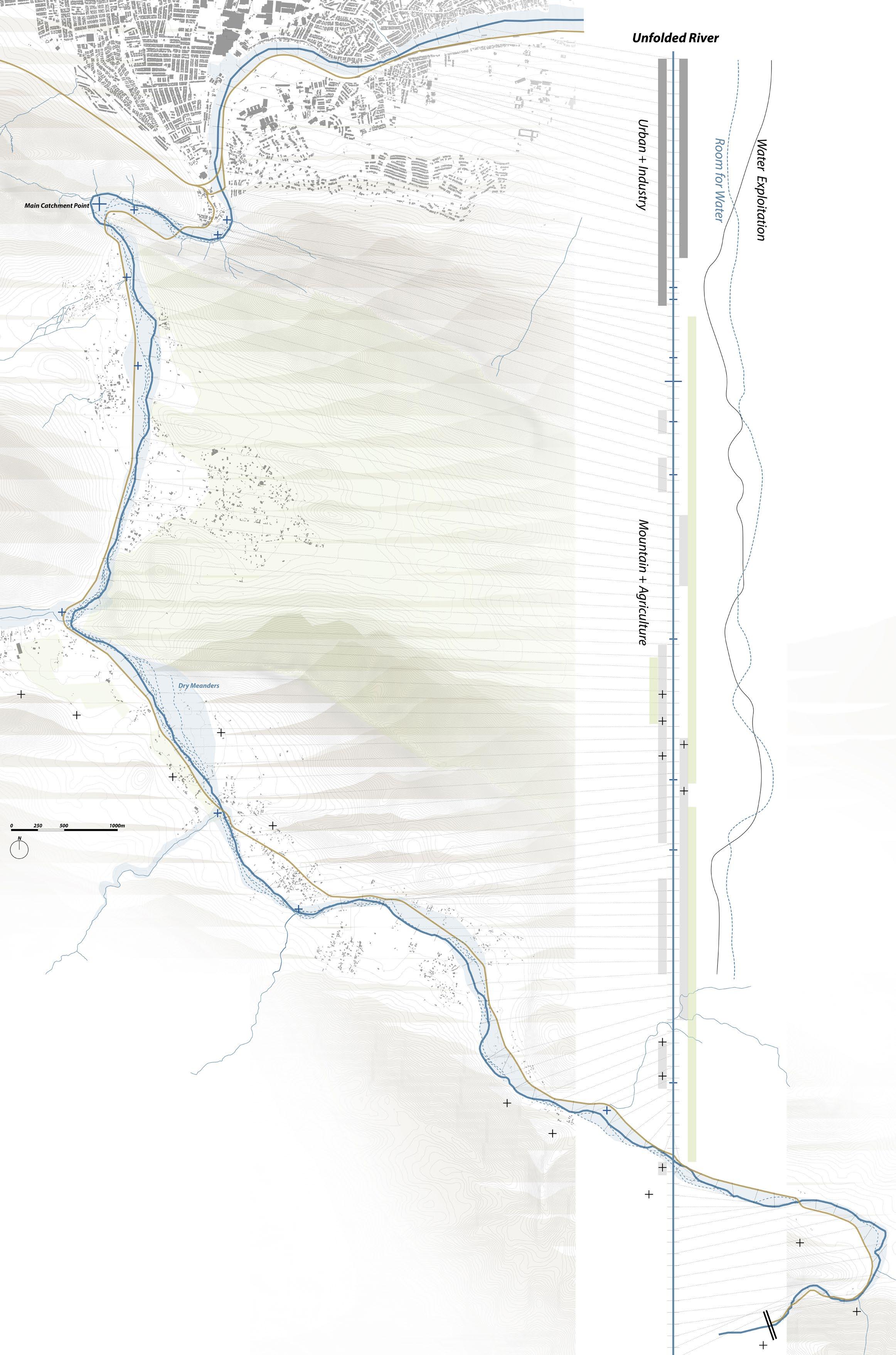
Sited at the confluence of these two rivers is the city of Binghamton, whose downtown has been surrounded by a system of levees and floodwalls constructed by the Army Corps. of Engineers in response to a devastating flood in 1935. Climate change has begun to increase both the frequency and ferocity of rain events in the Northeast, making the defensive hydrological borders common to cities like Binghamton at constant risk. The levees and floodwalls designed almost 80 years ago are sized inadequately to handle recent storms, and their inflexibility as forms can cause as much damage as they prevent.
My design proposes that the armored edge of the Susquehanna Rivers in Binghamton be thickened as a layered, multi-use green/blue infrastructure that reconnects water with land and builds social, ecological and hydrological resiliency.

Timeline: Binghamton's Flourish & Decline with Water

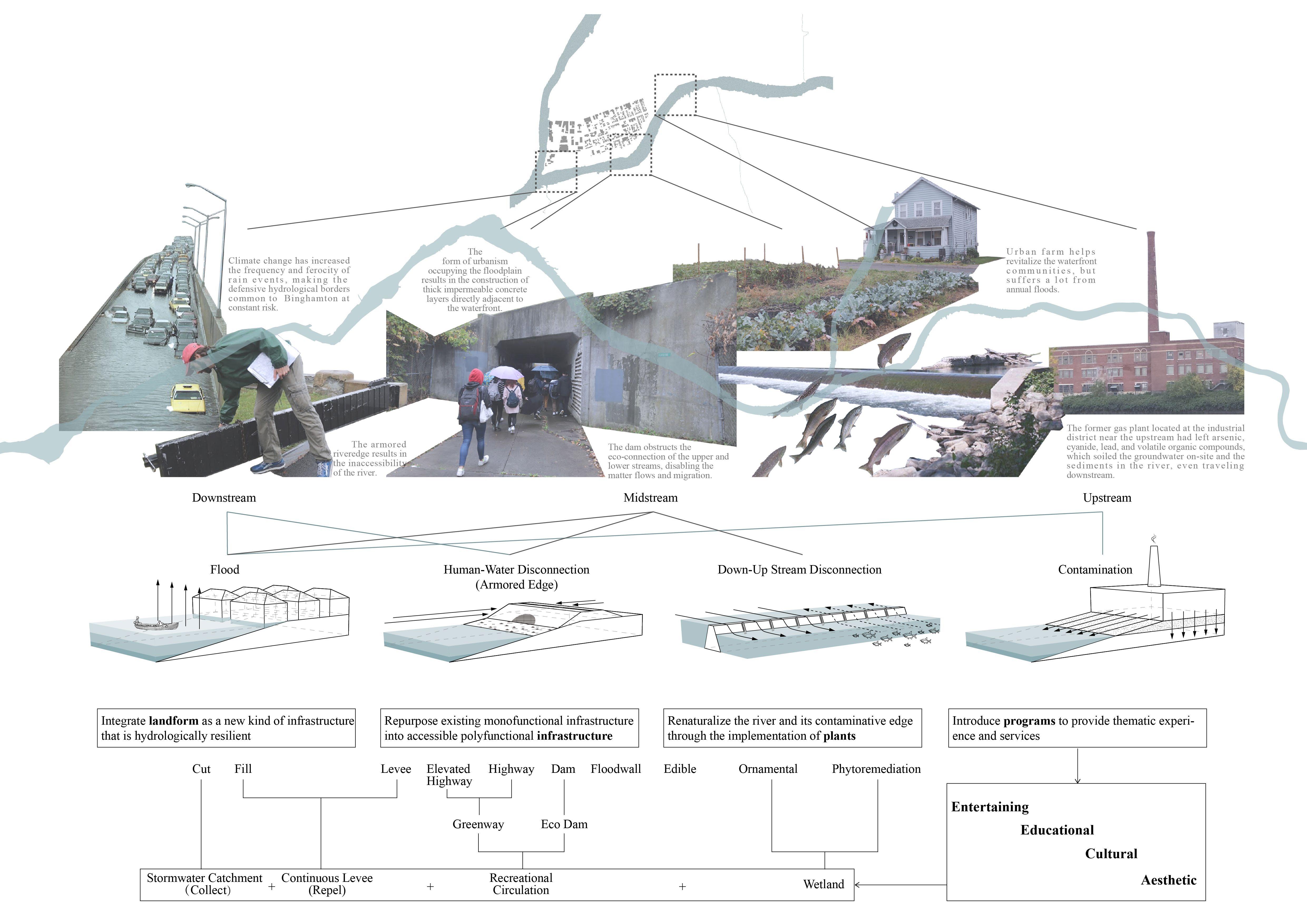
Barrier Study through Section
Physical & Visual
Inaccessibility
Repurpose Existing Grey Infrastructure
Existing Condition
Proposed Condition
Turn Grey to Green
Renaturalize the Edge with Plants
Construction
Phasing Diagram