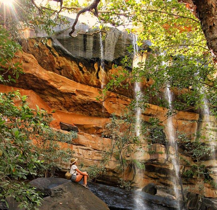
KIMBERLEY DESTINATION

CULTURE & TRAVEL THROUGHOUT THE KIMBERLEY


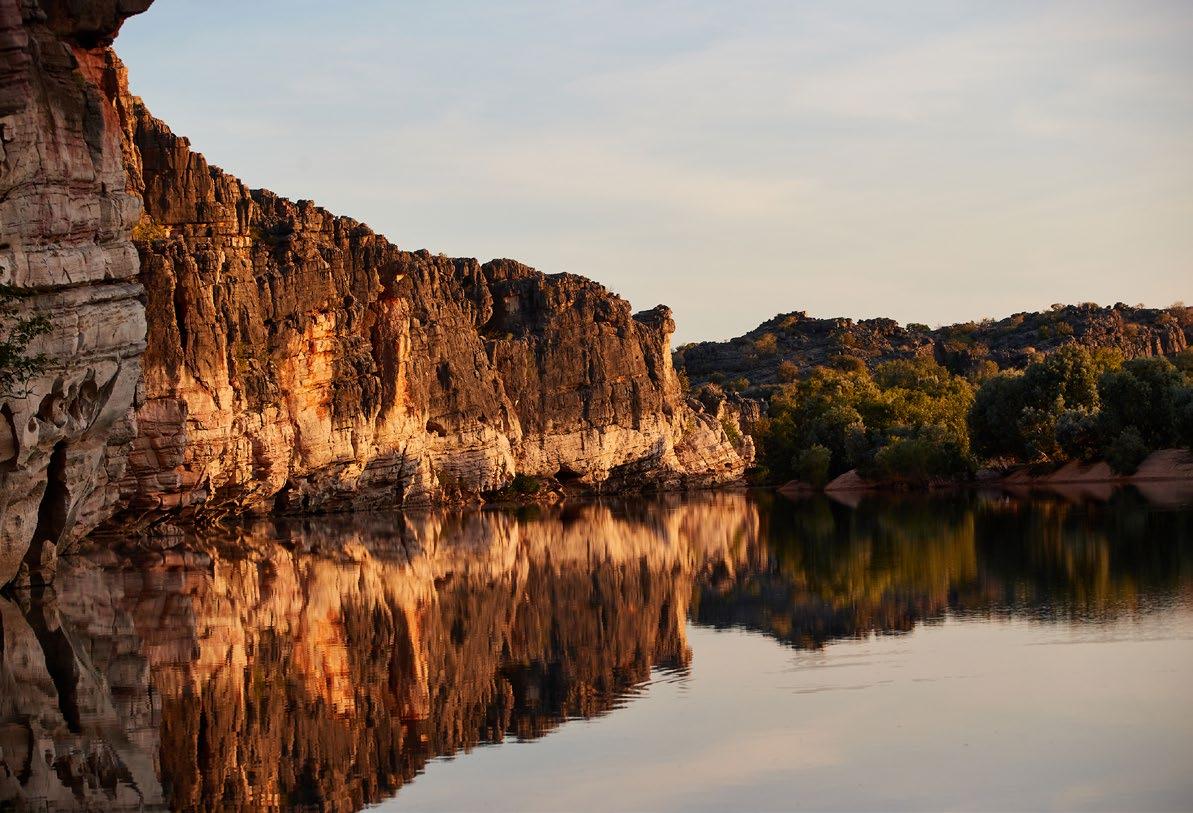
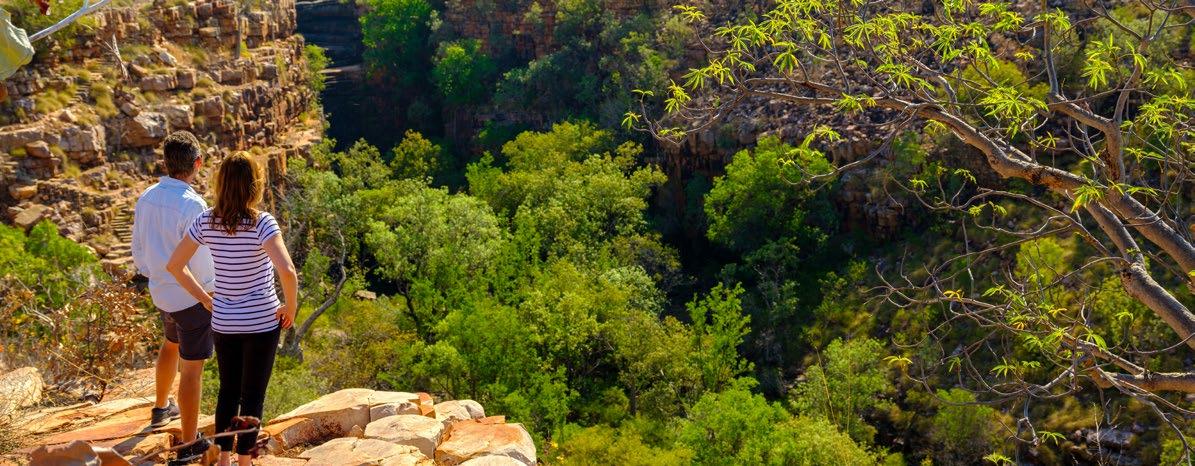
You really can’t find anywhere else in the world quite like the Kimberley region of Australia.
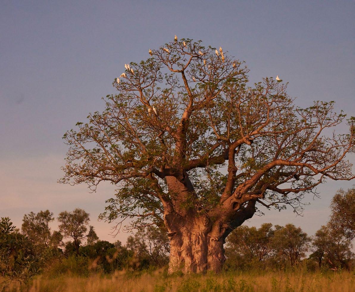
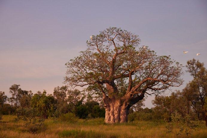
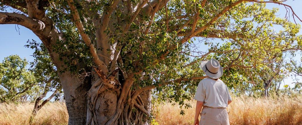
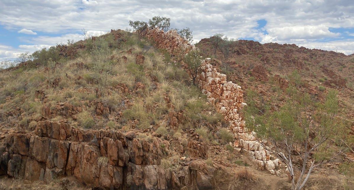
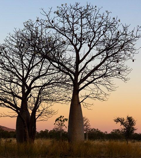
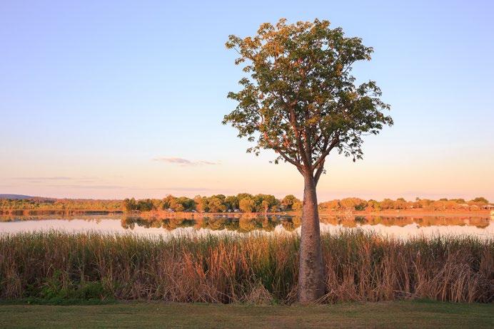
With huge Boab trees, amazing rock formations, vast valleys and amazing wildlife, The Kimberley region touches the hearts and souls of the hundreds of thousands of visitors each year.
Whether you are here to get out and camp, or to indulge in ancient culture, The Kimberley has something to offer everyone.
Naturally, the enchanting town of Broome can’t go without being mentioned.
With its Chinese history and laid-back culture the township of Broome not only offers some of the best sunsets in the planet, but it has fantastic food and beverage which is simply world class.
Camel rides, staircase to the moon and ancient dinosaur footprints are all here in the township of Broome and visiting here is a must do on your Kimberley adventure.
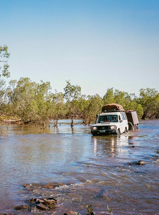
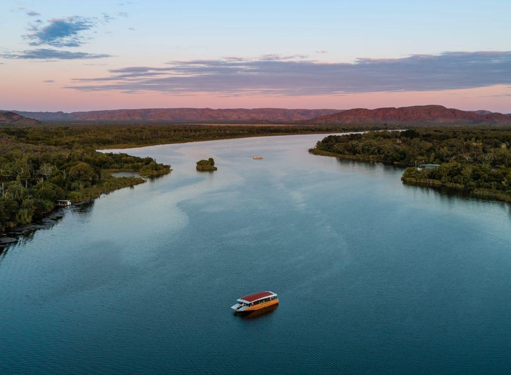
Although the distances between towns in The Kimberley are vast, travel is made easy here with an abundance of helicopter and fixed wing services. Every day, visitors are transported to the Buccaneer Archipalego, El Questro Resort and Lake Argyle where the enormity and vastness of the land reminds us all how insignificant we are on this planet.
One of my favourite hidden secrets is the Mowanjum Arts Centre in Derby and I urge you to drop in, particularly if you are heading along the Gibb River Road.
The Gibb is such an Australian icon for travellers and words here can’t do justice for
the experience that awaits those who pass through this route every year.
Crystal clear, night skies reveal millions of luminescent stars which you feel you are immersed in when you lie by the campfire and watch them at night.
Secret fishing holes, amazing birdlife and the simple, basic experience of living life without the modern-day pressures which are found in the cities. The journey across The Gibb will be forever cherished.
The magic of the Wolfe Creek Crater will cast your mind back three hundred thousand years, when a massive meteorite collided with Earth and left its mark forever. Imagine how the world would have rocked from its peaceful existence when this massive collision occurred.
Yet amongst this amazing country of natural formations such as Wolfe Creek Crater, The Bungle Bungles, the broad beaches, the stunning rivers, there is also the amazing Lake Argyle a man-made lake which is 20 times the size of Australia’s Sydney Harbour and one of Australia’s largest water catchments.
Whether you are in the Kimberley for a short break or to experience your lifelong travel dream, this area will touch you like nothing else on earth.
Enjoy the Kimberley and remember that Life is for Adventure!
JBG Executive Adventurer
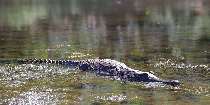
Be Crocwise! The Kimberley is home to both saltwater and freshwater crocodiles. Always observe crocodile warning signs and don’t assume it’s safe to swim if there is no sign.
Some permits and passes are required to make the most of a trip to the Kimberley or along the Gibb River Road. It is important that you download/print all relevant passes, maps, guides and information before you travel. Passes can be purchase online or at Visitor Centres throughout the Kimberley region.
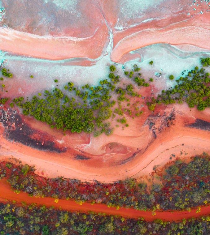
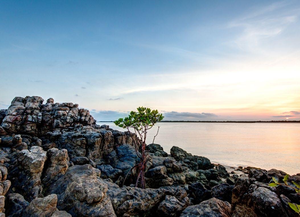
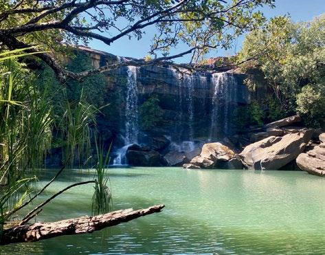
The far northern region of Western Australia, known as the Kimberley, boasts a jaw dropping landscape of cascading waterfalls, gorges, pristine beaches and unforgiving outback terrain. Like much of Western Australia, the Kimberley Region is secluded, but the isolation is the main attraction for most visitors to the area and the Kimberley is steadily gaining popularity as a travel destination. With a sense of adventure and a thirst for exploration, visitors are drawn to this rugged and picturesque wilderness, eager to experience its untouched natural wonders and unique cultural heritage.
Pago Mission ruins B13
Mungalalu-Truscott
Kimberley Coastal Camp
Surveyors Pool (Aunauyu)
Honeymoon Beach
McGowans Island
Longini Landing
Mitchell Falls Wilderness Lodge
Mitchell River National Park
Mitchell Falls Enid Falls
Prince Regent National Park
Laterite Conservation Park
Drysdale River National Park
Worriga Gorge Morgan Falls Euro Gorge
Marunbabidid Prap Prap Community
Bachsten Camp
Salvoni Gorge
Dillie Gorge
Isdell Gorge
Lennard Gorge
Dondun Community
Ngallagunda Community
Wongaroodoo Gorge Falls Cathedral Gorge Piccaninny Gorge Bellburn Airstrip
Ranges
Wunaamin Coservation Park Devonian Reef
River Gorge Miners Pool
Scotty-Salmond Gorge
Kupungarri Community Oombulgurri Mandangala Community Jimbilum Community Wuggubun
Kupungarri Community Tirralintji Community
Richenda Gorge Glenroy Meatworks
Dimond Gorge Mornington Wilderness Camp Sir John Gorge Cadjeput Hole
Fitzroy Crossing
Crowhurst Gorge Margaret Gorge
Hells Gate
Teronis Gorge
Tunganary Gorge
Gorge
Mini Palms Gorge Echidna Chasm
Bungle Bungle Wilderness Lodge
Nardji Cave Galeru Gorge
Ngumpan Cli
Wangkatjungka Community
O'Donnell River Gorge Neville Gorge
One Palm Tree Gorge
Junjuwa Bayulu Muludja Community Mingalkala Community Ganinyi Community
Eagle Hawk Crossing Gorge Morgans Grave
Ranges
Brim Gorge China Wall
Elvire Gorge Crocodie Gorge
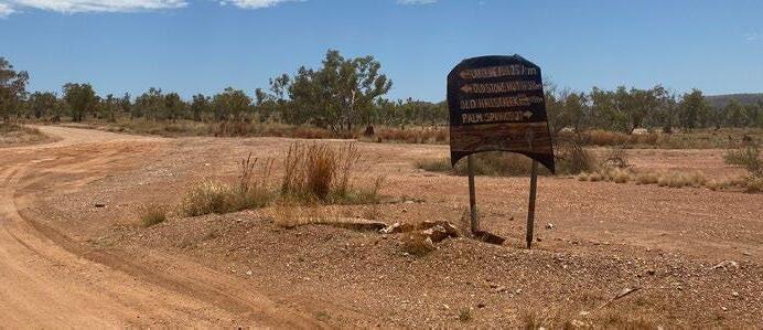
Sawpit Gorge Old Halls Creek Palm Springs
Marella Gorge
Wolfe Creek Crater
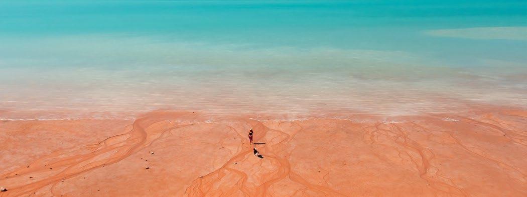
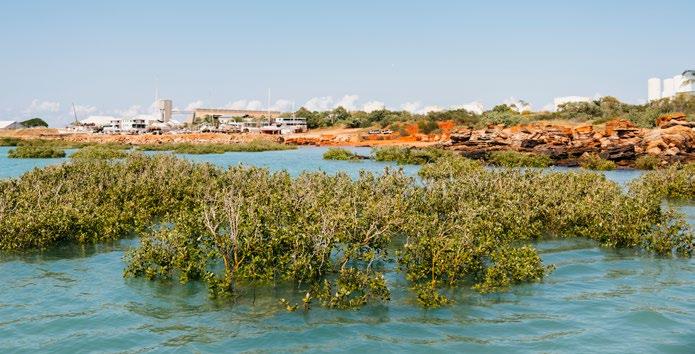
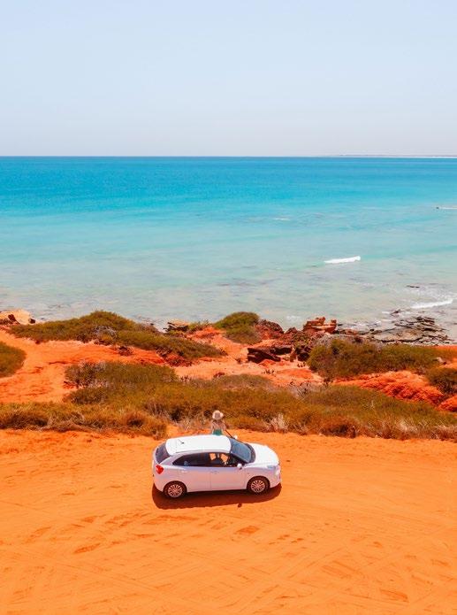
Everywhere you look there are landscapes that showcase the vivid beauty of Broome, where the contrasts of the outback meet a spectacular ocean expanse. The famed Cable Beach is a 22 kilometre stretch of coast which offers the quintessential beach holiday.
Broome is an enormously popular seaside town that straddles a peninsula approximately 15 kilometres long. It’s renowned throughout the world for its incomparable coastline. White sands, red rocks and cobalt blue waters form the edge that joins the rugged Australian desert with the Indian Ocean.
The traditional land owners of the region are the Yawuru people whose connection to the land dates back 40,000 years. The first official discovery of the area was made by explorer William Dampier back in 1688. Dampier’s journals, which chronicled his travels, attracted the attention of those keen to capitalise on the rich source of pearl shells in the region. Nearly two hundred years after Dampier’s discoveries, pearling established itself as a real industry which prompted the founding of Broome in
1883. In 1889, Cable Beach was given its name because of the telegraph cable that runs between Broome and Java.
There are remaining relics of Broome’s mother of pearl boom-time that recount the colourful history of the town. Meanwhile, the cultural heritage of the Yawuru people can be traced back through the sharing of artwork, language and stories they retain today.
Nowadays Broome and Cable Beach serve as a vibrant travel destination for Australians and overseas travellers, alike. Whether you’re interested in adventurous or relaxing activities, you’ll find everything you need during your stay here. In addition to its beachside attractions and town sights, Broome offers numerous tours that explore the region’s more remote wonders, such as the awe-inspiring Horizontal Falls.
The 22 kilometre stretch of white sand along Cable Beach, set against the stunning Indian Ocean, provides a breathtaking backdrop for sunset camel rides. Nearby, Gantheaume Point reveals ancient dinosaur tracks embedded in the red rocks during low tide. Broome’s historic Chinatown, overlooking Roebuck Bay, serves as a gateway for cruises to local pearl farms.
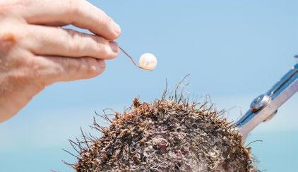
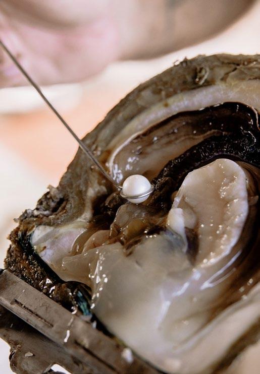
As a visitor to Broome, you would already be well aware that the backbone of the town’s economy stems from the richness of the pearling industry.
Pearling really came to the fore in 1861 when a new pearl oyster, Pinctada Maxima, was discovered off Nichol Bay. At the time, the world’s fashions which were dominated by the US and Europe were pearl mad. While jewellery was fashioned by this rare and magnificent sea find, an additional bonus was the mother of pearl.
The region subsequently became the most significant source of mother of pearl in the world and drove the pearling industry in the early 1900s. During the next century, many of the most important natural pearls ever discovered were fished from the pristine waters surrounding Broome. Today, Australia’s Pinctada Maxima beds are the world’s last remaining source of wild pearl shell used for pearl cultivation. At its peak, 80 Mile Beach and the Broome region supplied 75% of the world’s production of mother of pearl,
with some 400 vessels exporting up to 2,000 tonnes per annum. During the time, 3,500 people were employed in the fishery, and the industry was crucial to the commerce and development of northern Australia.
In the 1950s, however, the plastic button was invented which replaced a practical need for the pearl. Virtually overnight, the pearling industry hit on hard times and luggers were left to rot up and down the coastline. It was within this landscape that innovation came into play. The culture of pearls would become the primary focus of a new Australian pearling industry.
Discover the ancient backstory to Broome’s beautiful pearls. Grown in the pristine coastal
waters of Broome, experience the journey of the only gem created by a living organism.
Book a pearl farm tour with Willie Creek Pearls which takes you through the journey of the pearl through the process of seeding, cultivating, and harvesting.
Allure South Sea Pearls on Dampier Terrace in Chinatown offers a wonderful selection of pearl strands, earrings, bangles, rings, and pendant necklaces.


Willie Creek Pearls is a Western Australian family owned and operated business with 35 years of service excellence. They sustainably produce the best pearls in the world: Australian South Sea Cultured Pearls.
The Willie Creek Pearl Farm tour is a multi award-winning tour which allows you to see how passionate the team are about every part of the unique story of The Pearl of Western Australia, from shell to showroom. It is a ‘must do’ experience for everyone visiting Broome.
It’s a paradise in an isolated part of the world and a beautiful place to experience the wonders of pearling. The crystal-clear waters and mangrove lined banks of Willie Creek are home to all kinds of wildlife, from barramundi to brolgas and even a few saltwater crocs!
Willie Creek Pearls’ knowledgeable guides will reveal the intricate processes of today’s modern cultured pearling industry – from the seeding of an oyster to the harvesting and grading of a pearl, right through to the final stunning product on display in the showroom.
From the magnificent Kimberley landscape to the array of things to see and do, a day at Willie Creek Pearl Farm is one you’ll remember for years to come.
Transport to Willie Creek Pearl Farm is available by coach with bus pickup from your accommodation, self-drive or helicopter. Book your tour today!

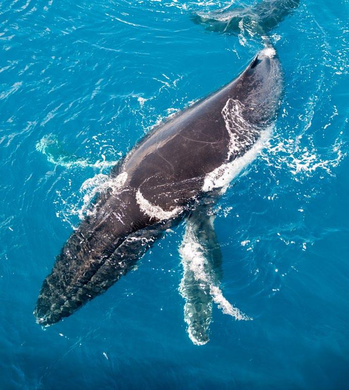
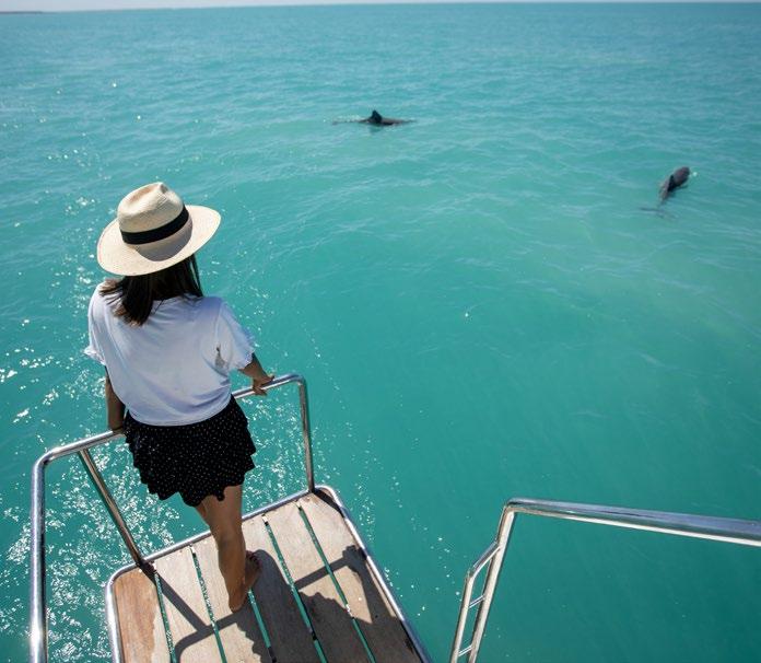
There is always something to see in the pristine waters around Broome. From whale watching, seeing the rare Snubfin dolphin, to a guided fishing charter, your adventure awaits.
During whale season in Broome, the surrounding Indian Ocean plays host to the world’s largest population of humpback whales with over 35,000 whales expected to travel the coast each year.
Every year these humpback whales migrate home from summer feeding grounds in the frigid waters of the Antarctic to mate and give birth in The Kimberley’s warm, tropical waters. Once hunted to the brink of extinction for oil and baleen, with a mere 500 individuals left by the early 1960s, Western Australia’s humpbacks have staged a magnificent recovery.
The humpbacks’ calving grounds extend from Gourdon Bay, south of Broome, through to the Buccaneer Archipelago to Camden Sound, the ‘maternity ward’ for the humpbacks, with newborn calves frequently seen off Broome.
The Kimberley’s humpbacks delight tourists July to September with spectacular displays of breaching, spyhopping, tail fluking and pectoral slapping.
Snubfin dolphins are a rare breed of dolphin, endemic to northern Australia. Roebuck Bay is home to over 130 snubfin dolphins, making it the largest permanent population in Australia. They look very different to other dolphins as they have a rounded forehead with no beak. Don’t miss experiencing these awe-inspiring creatures.
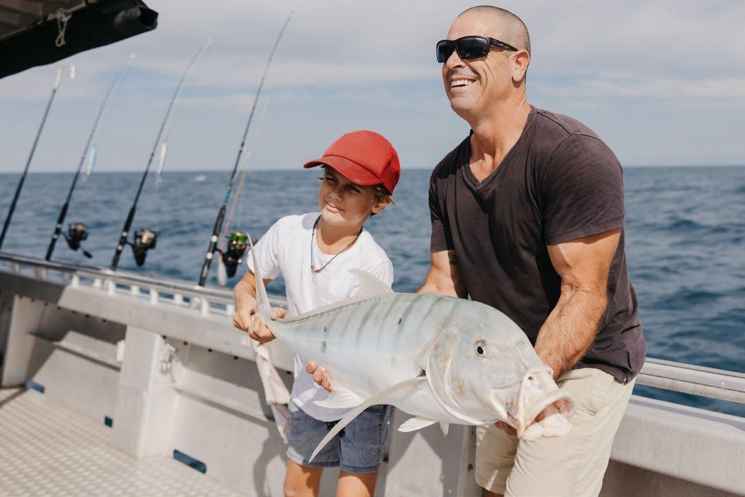
Though game fishing in Broome is influenced largely by the tides, there’s great fishing to be had in this part of the world for both amateurs and enthusiasts, alike.
Broome offers both offshore and inshore fishing with reef, sport and creek fishing available. Some of the fish you can expect to catch in the area are:
Reef Fishing - Snapper, Coral Trout, Red Emperor, Sea Perch, Trevally & Cod.
Sport fishing - Giant Trevally, Spanish Mackerel, Cobia & Sailfish.
Creek fishing - Mangrove Jack, Black Jewfish, Threadfin Salmon & Barramundi.
There’s plenty of great fishing spots in and around Broome so you’re bound to bring home a catch of the day. Willie Creek is a renowned fishing location in Broome as is Cable Beach. The Town Jetty is also a popular fishing spot and it’s recommended you get out to Dampier Creek. There’s no shortage of reputable fishing charters available in the area.
Absolute Ocean Charters offer Whale Watching Tours as well as Eco Sunset & Snubfin Dolphin Cruises. Full or half day fishing charters and customised private charters are also available.
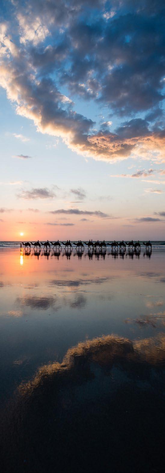
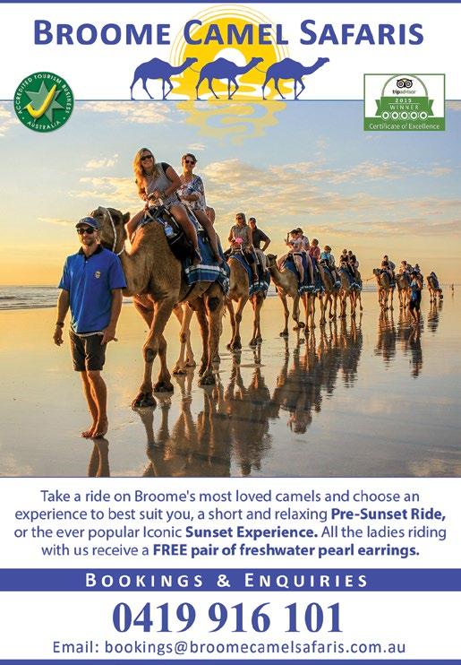
Nothing is more iconic than a camel ride along the stunning Cable Beach in Broome. Stretching 22 kilometres, Cable Beach is known for its pristine white sand and clear tropical waters, and a popular way to take in these views is from the top of a camel.
The camel safaris in Broome are steeped in fascinating history.
The first camel was imported into Australia in 1840, followed by another 24 in 1860 to aid the Burke and Wills expedition. Over the next 50 years, approximately 12,000 camels were brought from India and Palestine, predominantly the camelus dromedarius - the onehumped camel. Adapted to harsh climates, camels proved invaluable to the Australian labour market. By 1890, they were heavily used for transport in the Western Australian goldfields. However, by the early 20th century, motorised vehicles began to replace them.Today, Australia’s feral camel population is estimated to be around 300,000.
While it’s well known that camels can survive without water for several weeks, they are also well-suited to the Australian outback due to the vast array of plant species they can eat.
Camels can work for several decades and carry up to 600kg.
There are several camel ride options available. The most popular is the sunset ride, but there are also seasonal morning rides and slightly shorter pre-sunset rides which are perfect for families with little ones or those who prefer an earlier departure.
Broome Camel Safaris is the oldest and most reputable camel tour operator in Broome. Operated by the ‘true camel lady,’ call 0419 916 101 for bookings and inquiries.
At Gantheaume Point near Broome, see the ancient dinosaur footprints which are 130 million years old.
Just a five-minute drive from the centre of Broome, Gantheaume Point offers a unique glimpse into prehistoric times. When the tide is low, you can explore dinosaur footprints preserved in the rocky reef. These tracks, extending from Gantheaume Point to James Price Point on the Dampier Peninsula, have been verified as belonging to up to seven different dinosaur species from the Cretaceous period, including sauropods, ornithopods, and stegosaurus.
A plaster cast of the tracks has been embedded at the top of the cliff for anyone who visits at high tide or doesn’t want to walk on the reef.
As well as as harbouring these unique dinosaur footprints, Gantheaume Point offers stunning coastal scenery. Here, the fiery red cliffs meet the turquoise water of the Indian Ocean in dramatic fashion.
Gantheaume Point is well known for its rock pools. Located on the northern side of Gantheaume Point is Anastasia’s Pool. This rock pool was modified by a former lighthouse keeper for his wife, Anastasia, who was crippled with arthritis. The warm temperatures of the Indian Ocean were said to offer her relief from her chronic condition. Unfortunately, Anastasia’s Pool was damaged by a storm in 2014.
There are other pools near Anastasia’s Pool. Be sure to check the tides before visiting to ensure they’re full and use caution when visiting.
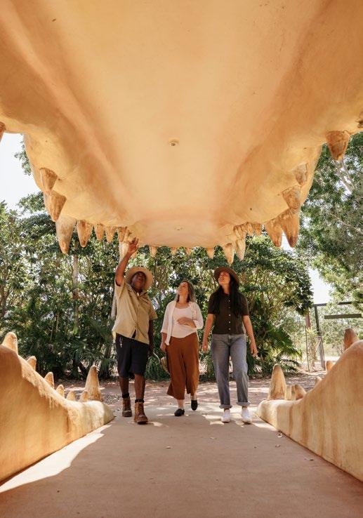
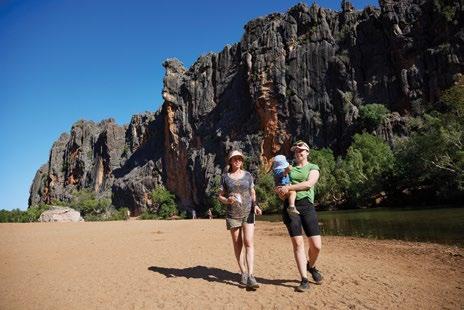
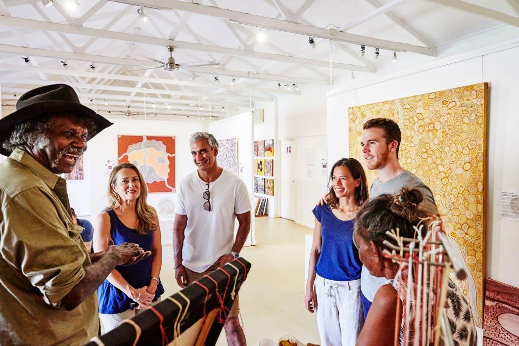
It is my pleasure to introduce you to the Shire of Derby/West Kimberley, a region steeped in rich cultural heritage and breathtaking natural wonders. Our Shire is home to some of Australia’s most iconic landmarks and vibrant communities.
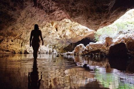
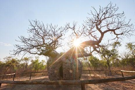
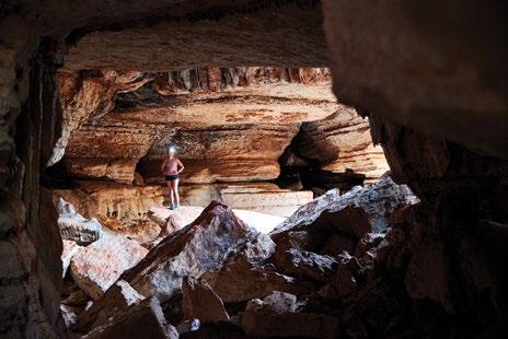
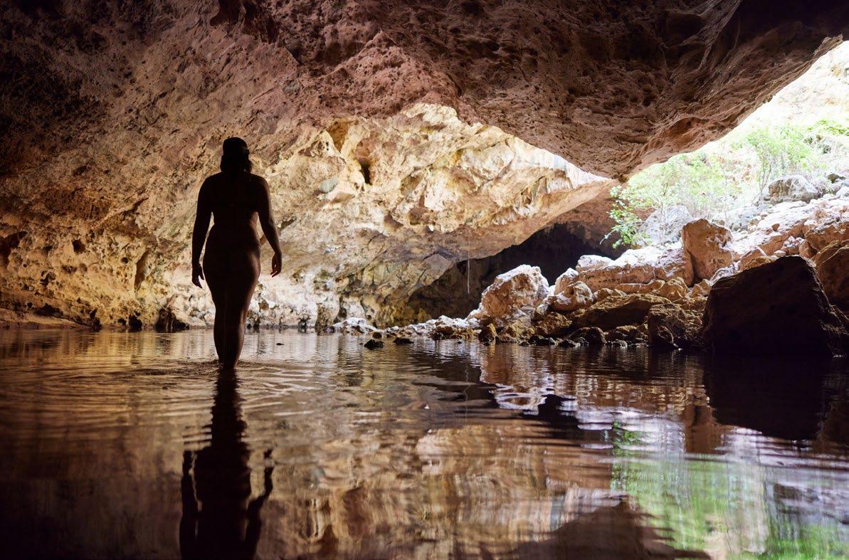
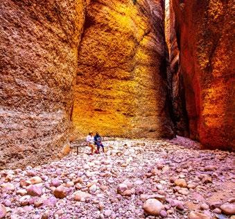
Explore the historic Boab Prison Tree, a living relic of our past, or venture into the ancient Mimbi Caves to witness the extraordinary geological formations and cultural significance they hold. The stunning Geikie Gorge and the mysterious Tunnel Creek offer unforgettable experiences that connect you with the land’s deep history.
The King Sound serves as the gateway to the mesmerizing Horizontal Falls and a myriad of beautiful islands, perfect for adventurers and nature lovers alike. Our region is also a central hub for Aboriginal art, showcased brilliantly by the Sculptures on the Marsh in Derby.
The Gibb River Road invites you to traverse its rugged landscapes, uncover hidden waterfalls, and embark on countless adventures that epitomize the spirit of the Australian outback.
On behalf of all residents, I warmly welcome you to the Shire of Derby/ West Kimberley. We hope you enjoy the rich cultural experiences, natural beauty, and the welcoming community that define our remarkable region.
Peter McCumstie
of Derby / West Kimberley


The Shire of Derby/West Kimberley acknowledges First Nations peoples living and working in the Shire. Council recognises the people of the Warrwa, Bardi, Jawi, Ngarinyin, Worrorra, Nyikina, Mangala, Unggumi, Bunuba, Walmajarri, Kija, Gooniyandi, Oogardang, Oomeday, Yow Jabi and Wangkatjunka Nations as the original custodians of the lands now known as Shire of Derby/West Kimberley. On behalf of the Shire, Council pays respect to their Elders, past, present and future and extends that respect to all Aboriginal Australians living within the Shire of Derby/West Kimberley.
Located 220 kilometres north of Broome, the township of Derby was once the main commercial centre for the region and the large hospital highlights how much people still rely on the town as a bit of a hub for those in outlying areas.
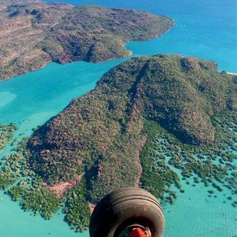
Derby is very much connected to the varied waters that surround the region and this includes the 800 island archipelago just north of the town and called Buccaneer Archipelago.
This unique and pristine environment covers 50 square kilometres and is located at the head of King Sound. It is the home to the Yawijibaya and the Unggarranggu people and if fishing is your thing, then you won’t be disappointed if you take a tour out to cast a serious line.
There are a few operators that offer tours to the area but fishing here is serious business and if you plan to fish the area, then check out the Derby website australiasboabcountry.com.au or call (08) 9191 0999
Very much a sleepy hollow, Derby boasts extremely friendly locals who will always offer a smile and advice, especially to the myriad of tourists that pass through the town, mostly on their journey across the Gibb River Road which starts or finishes close by.
The art in Derby is extremely interesting and for those interested, be sure to go to Norval Gallery, Jila Café and Mowanjum Gallery.
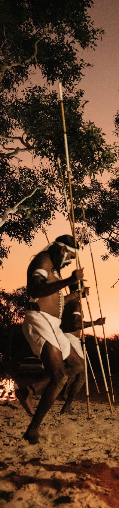
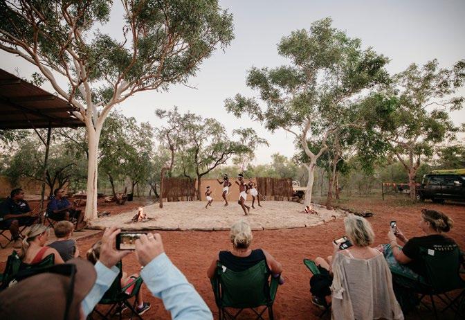
The Mowanjum Aboriginal Art and Culture Centre is a world class facility and vibrant hub for the Worrorra, Ngarinyin, and Wunumbal tribes near Derby. It hosts exhibitions, workshops, and community projects, offering visitors an immersive experience through multimedia and interactive displays that share the rich history and traditions of the Wandjina Wunggurr people. The Mowanjum showcases art which is created by talented local artists where visitors can interact with Indigenous art and culture through video, carvings, and wall art.
Each year in the first week of July, the Mowanjum Festival is held at the Mowanjum Aboriginal Art and Culture Centre and around 1,000 visitors per year make the pilgrimage to join the festivities. Observe and learn dance,
watch how intricate body art is applied, enjoy foods and kick up your heels in what is an absolute unique experience.
Orchre painting, body painting and food trucks offering traditional fare are all on display and there are afternoon workshops, followed by the evening of Junba traditional song and dance under the stars.
The Leprosarium, or Bungarun, located near Derby, was an isolation facility for Indigenous Australians with Hansen’s disease from 1936 to 1986. As the largest institution of its kind in Australia, it housed over 1,200 people. The site features 350 graves, many unmarked, and a memorial wall listing the names of those who passed away. Visiting Bungarun offers a unique insight into this significant part of Australia’s history and its impact on the local Indigenous community, former patients, nursing staff and the history of medical services in Western Australia. You need to call into the Visitors Centre and organise a key to the Leprosarium and it is a good idea to call through first in case someone else has gone in before you. Call the Derby Visitor Centre on (08) 9191 0999
Fishing around Derby is a dream for enthusiasts, thanks to its huge tidal variations and over 1,200 islands. With the world’s second-highest tides reaching up to 11.8 meters, the area teems with diverse marine life, including barramundi and Cherabin.
In Derby, you can enjoy fishing from the Derby Jetty, where you might catch salmon, mulloway, and mud crabs, or try your luck with a crab net. For boat fishing, explore the King Sound inlet and the mouths of the Fitzroy, Meda, Lennard, May, and Robinson rivers. If you’re up for an offroad adventure, visit Point Torment or May River. South of Derby, obtain permission from Yeeda Station to fish at Langi Crossing, Telegraph Pool, or Pelican Pool, and try the Willare Bridge for barramundi.
Contact Derby Visitor Centre for up-to-date information and fishing tour operators with great local knowledge.
Always be crocwise when fishing in these areas.

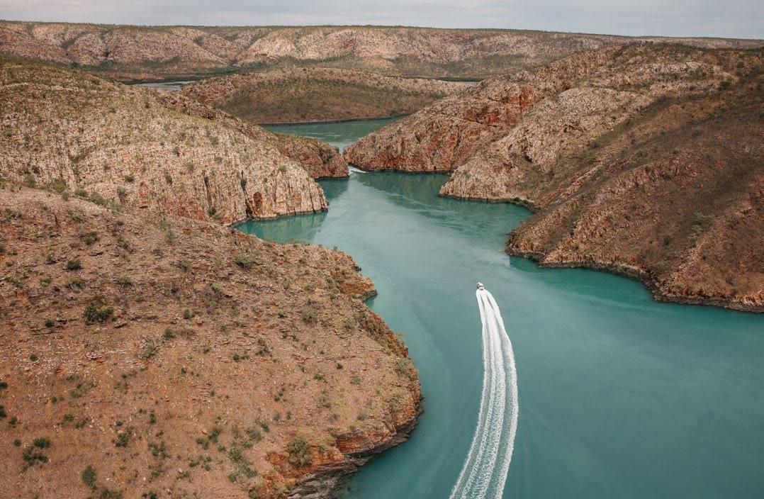
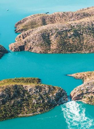
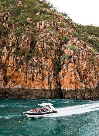
It is well worth the journey by boat or plane to witness one of the most powerful and natural spectacles in the world.
The Horizontal Waterfalls is a natural feature of the breathtakingly beautiful Buccaneer Archipelago, which Sir David Attenborough proclaimed to be one of the greatest natural wonders in the world.
The falls are formed by the massive tides that rise at such a speed that large volumes of water are trapped between the vertical rock walls. When the tide turns the water is released again, causing the ‘waterfall’ effect. There are two gaps: the smaller is approximately 7.5m wide whilst the bigger gap is three times as wide and, at times,
there can be a 4m high waterfall between the bays. For a memorable experience and to view the falls up close, take an exhilarating fast boat ride through the gorges.
The Buccaneer Archipelago is a collection of about 1,000 islands, and the coastline travelling north from Broome up to the Dampier Peninsula is beautiful. There are several operators offering scenic tours to this spectacular formation. Horizontal Falls Seaplane Adventures offers powerboat rides through the falls as well as seaplane flights.


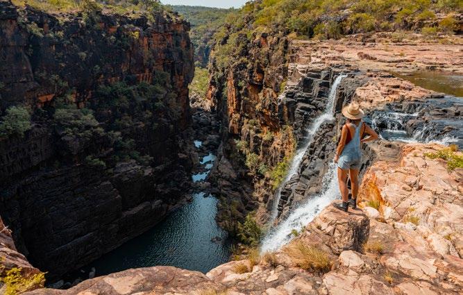
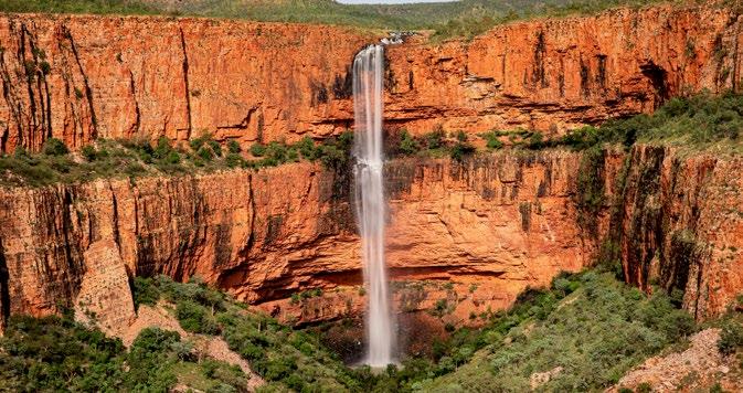
For hardcore 4WD enthusiasts, a trip to Punamii-Uunpuu or the Mitchell Falls is the dream of a lifetime. Although regarded as one of the most unique and difficult places to get to in Western Australia, every year, visitors make the pilgrimage to this remarkable and out of the way area.
There are helicopter tours to the area which are recommended when the falls are in full force which is during the wet months of February and March and when it is virtually impossible to get to with a vehicle.
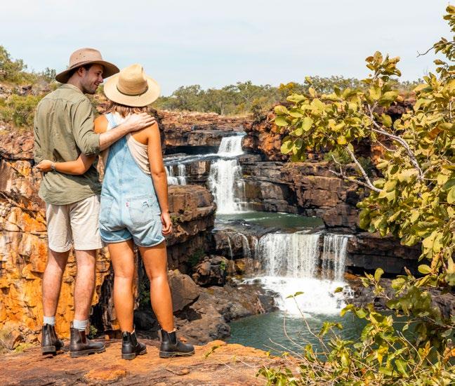
The area is very remote and travellers to the area should be well prepared in the event of an emergency. Good food, water, medical kit and satellite phone are recommended for a trip to the falls. The preparation may seem arduous, but the trip will stay with you for a lifetime and is absolutely worth it.
Visitors will need a Uunguu Visitor Pass and which can be applied for online by visiting wunambalgaambera.org.au
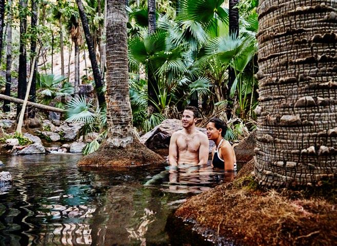
Heading towards Mitchell Falls, stop at King Edward River or Munurru which is open from May until October each year.
Camping at King Edward River is open annually from 1 May to 15 October and managed by the Traditional Owners. There is river swimming, nearby waterfalls, campfires (BYO firewood), bird-watching, wildlife, bushwalking and onsite toilets.
The camping here isn’t free, and you will need to book online when you organise your Uunguu Visitor pass.
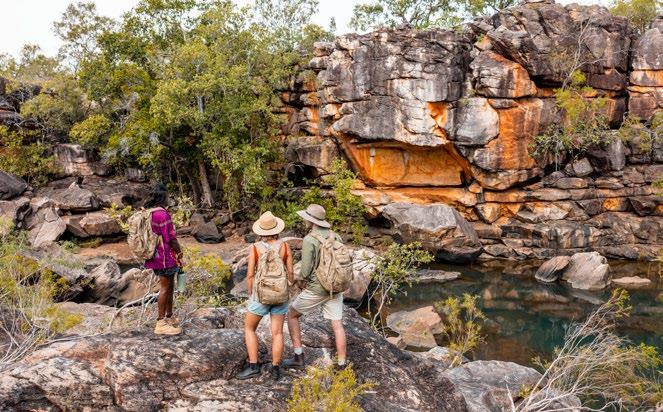
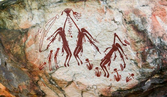
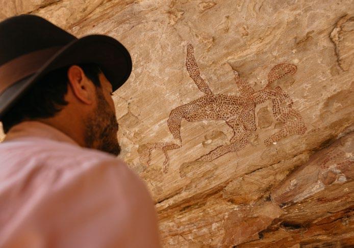
This entire region is filled with fantastic rock art, which is thousands of years old. You can stop at the Munurru Ranger Base and book a tour with a local guide for around $20 per person. These tours are not just interesting, they give visitors the chance to connect with local people who want to show you their home and share their deep culture.
Visitors to Mitchell Falls are required to have an Uunguu Visitor Pass (UVP), which can be purchased online at wunambalgaambera.org.au before arriving as there is no public internet/phone access on Wunambal Gaambera Country.
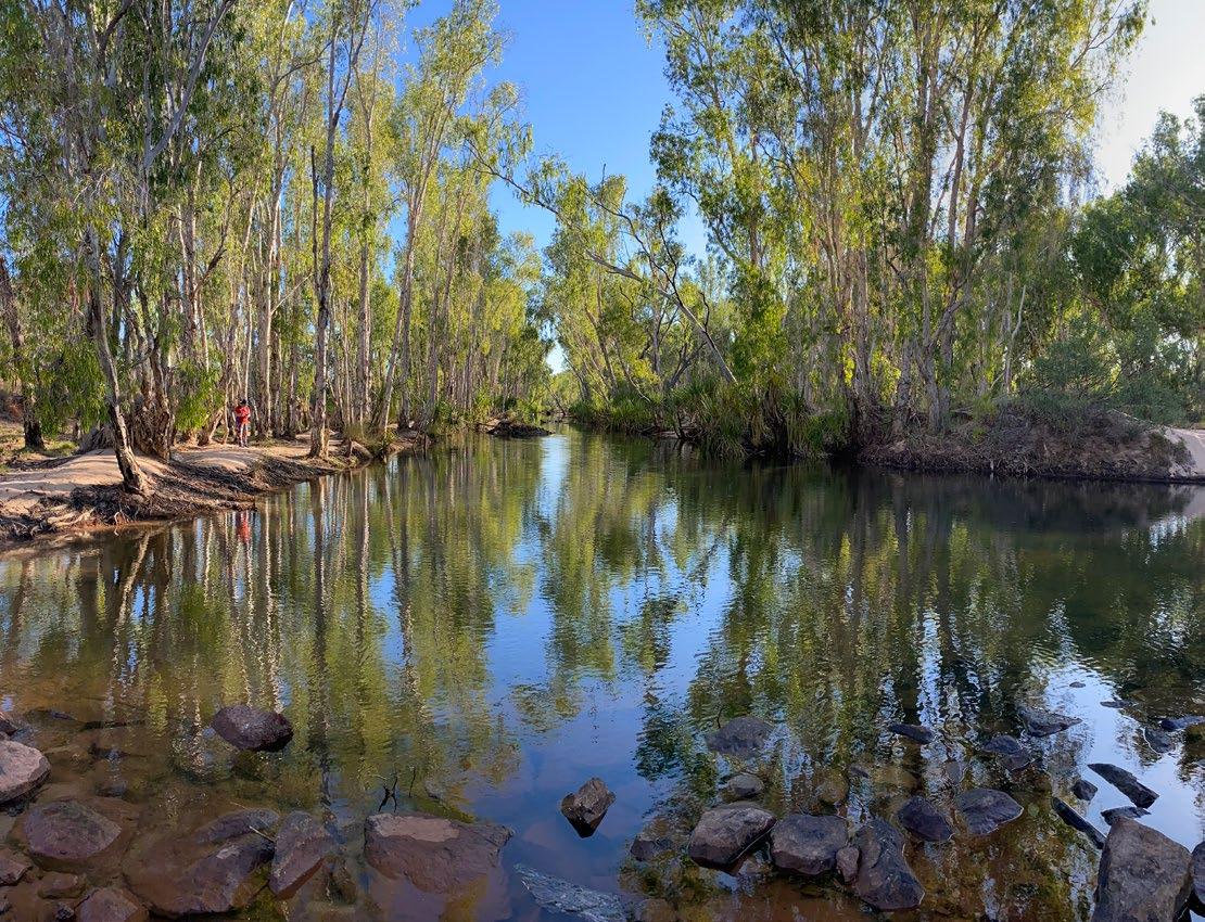
The Durack River has become a popular site and destination for fishing, bird watching and photography. Like many of the destinations across The Gibb River Road - The Durack River is intriguing not only for its beauty and serenity but for the history that surrounds it.
In 1879, Alexander Forrest became the first European to explore the Kimberley. Forrest’s expedition uncovered a rich and complex ecosystem, inhabited by a diverse range of flora and fauna, as well as a wealth of natural resources which paved the way for exploration through the Kimberley region. Shortly thereafter, Michael Durack and the Durack family arrived.
The Durack River is named after the well-known Durack family, who were pioneering pastoralists in the Kimberley region. The Durack family arrived in the area in the 1880s and established a number of cattle stations, including the legendary Argyle Downs. The family also played an important role in the development of the Kimberley region, helping to establish infrastructure such as roads, bridges and telegraph lines.
Today, the Durack River is a popular spot for fishing enthusiasts. The river is home to a variety of fish species, including barramundi, catfish and bream. Bird watchers will appreciate the abundance of birdlife that can be found in the area, including wading birds, eagles, and waterfowl. While photographers are often drawn to the stunning landscapes and sunsets that the Durack River provides.
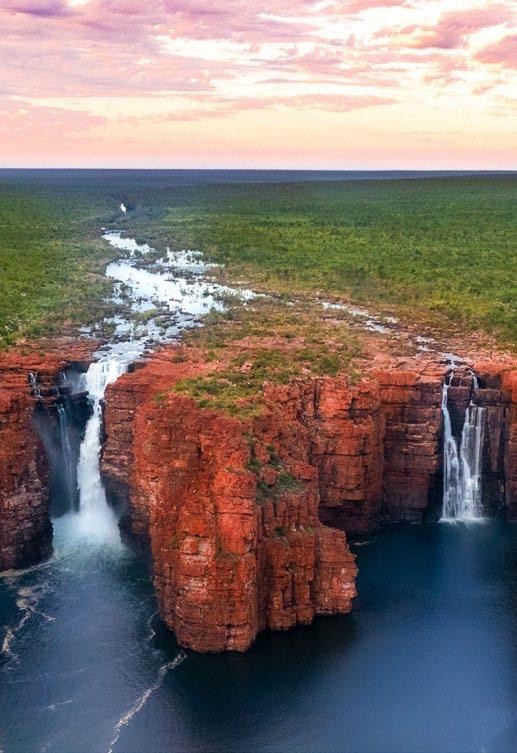
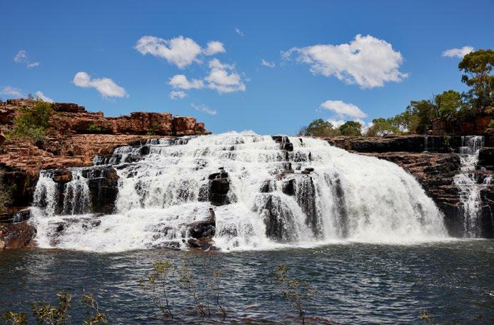
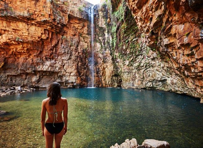
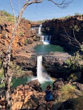
Tucked away in the depths of the North Kimberley Marine Park, The King George River is a scenic, sandstone dreamland, with waterfalls that wash away into the abyss.
The falls are inaccessible by vehicle but can be seen from the air or on a cruise down the river. Whether you decide to go by plane or by boat, the river itself is surrounded by towering cliffs and lush vegetation, making for a breathtaking view at every turn.
One of the main attractions of the King George River is the King George Falls which plunges into tidal waters over sandstone cliffs 100m high to form Western Australia’s highest twin waterfalls.
Regardless of how you choose to experience it, the King George River is a must-see attraction for anyone visiting the Kimberley region. Its natural beauty is truly astonishing.
Permits are required when entering Kalumburu at a cost of $50 per vehicle. This can be done on arrival at the Community Resource Centre or the Uraro Store.
An Entry Permit is also required for transit through Aboriginal Reserves, including Kalumburu, and can be obtained online from WA Aboriginal Affairs, or call (08) 6551 8002. You should apply for this before you leave.
Kalumburu is an Indigenous community located on the northern coast of the Kimberley Region.
The history of the Kalumburu community is deeply rooted in the land and culture of the Indigenous people who inhabit the area. Prior to European colonisation, the land was a vital resource for the Indigenous people, who relied on the natural resources found in the area for survival. These resources included bush tucker, hunting grounds, and ceremonial sites.
In the early 1900s, Christian missionaries arrived in the region, and established a church mission at Kalumburu. The mission was primarily focused on converting the Indigenous people to Christianity and assimilating them into European ways of life. Nonetheless, to this day, the community maintain a strong connection to their heritage and culture.
Today, the Kalumburu community is known for its unique Indigenous culture, which is reflected in their art, music, dance and stories. The community has a strong sense of identity, and they are committed to preserving their cultural heritage for future generations.
One of the few perennial rivers in the region, the Drysdale River supports a wide range of plant and animal species. Known for its beauty and remoteness, the surface sparkles as the sun beams off it.
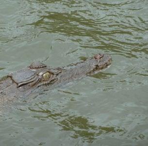
While the birdlife makes the river as spectacular as it is to see – the muddy banks and riverbed belongs to the oldest creature on the planet. For over 100 million years, the saltwater crocodile has inhabited the Australian waterways. Throughout the Kimberley region, the prehistoric reptiles thrive in the warmth and live to eat; hunting anything.
The river contains several permanent pools some of which have examples of Indigenous Australian art known as Bradshaw paintings that can be found along the cliff faces.
Drysdale River National Park features a diverse landscape of open woodlands and the broad waters of the Drysdale River. There are pools,
creeks, rugged cliffs, gorges and the two large waterfalls: Morgan Falls and Solea Falls. It is usually easy to spot crocodiles in the pools below Solea Falls.
Along with the community permit required to enter Kalumburu, an Entry Permit is also required for transit through Aboriginal Reserves and can be obtained online from WA Aboriginal Affairs, or call (08) 6551 8002. You should apply for this before you leave.
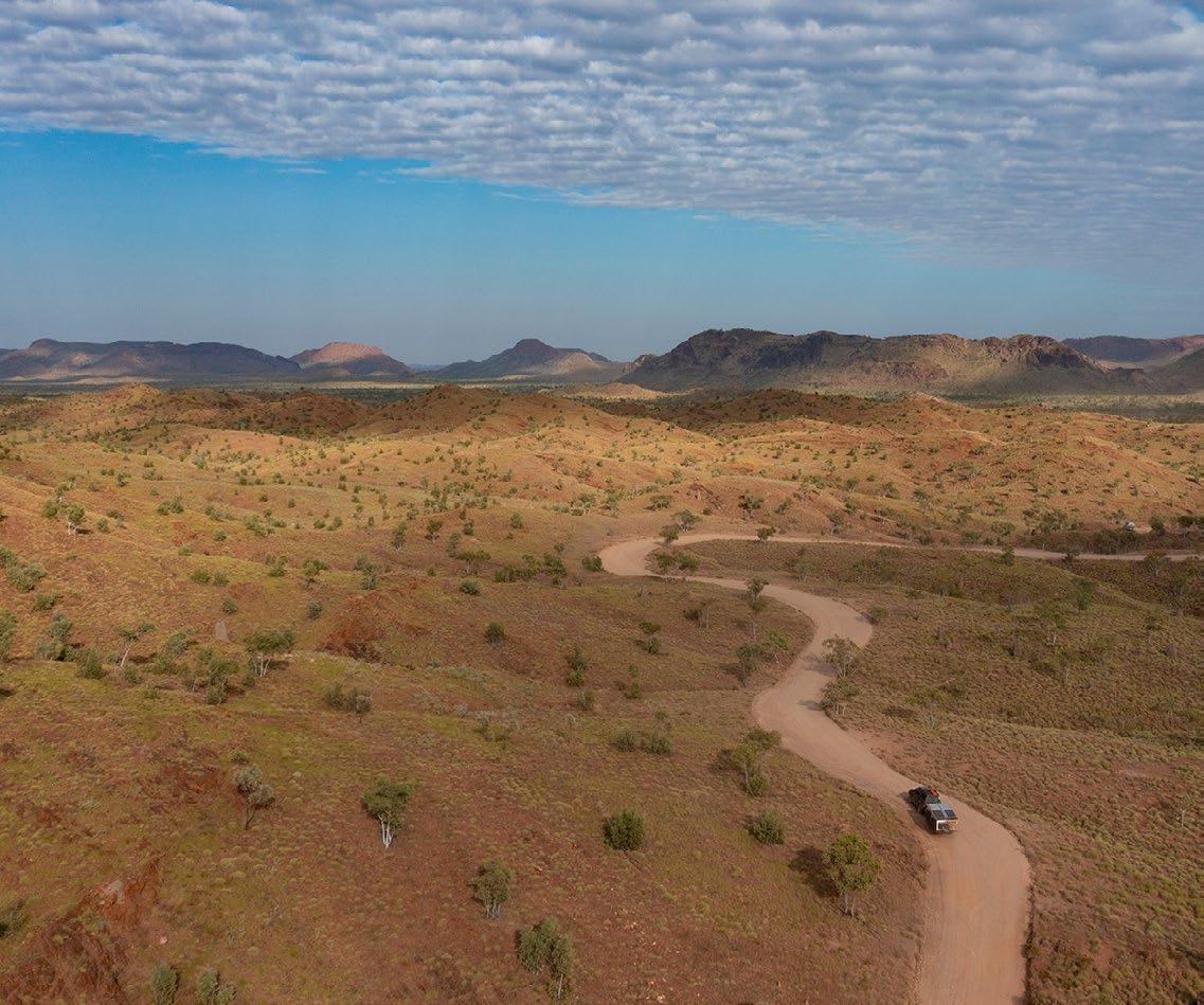
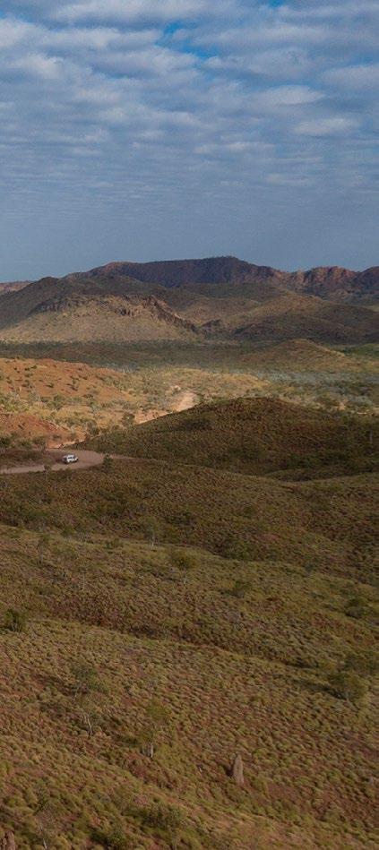
The Drysale River National Park is extremely rugged and remote wilderness being the largest and least accessible park in the Kimberley region. Untouched and spectacular from the air.
“
THE GIBB IS ONE OF THE BEST WAYS TO SEE THE KIMBERLEY.
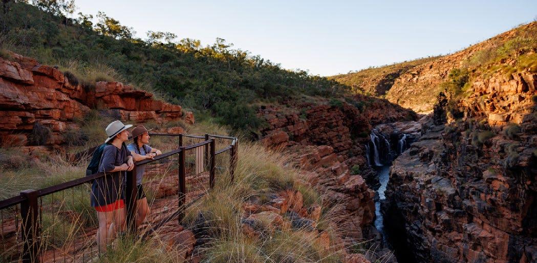
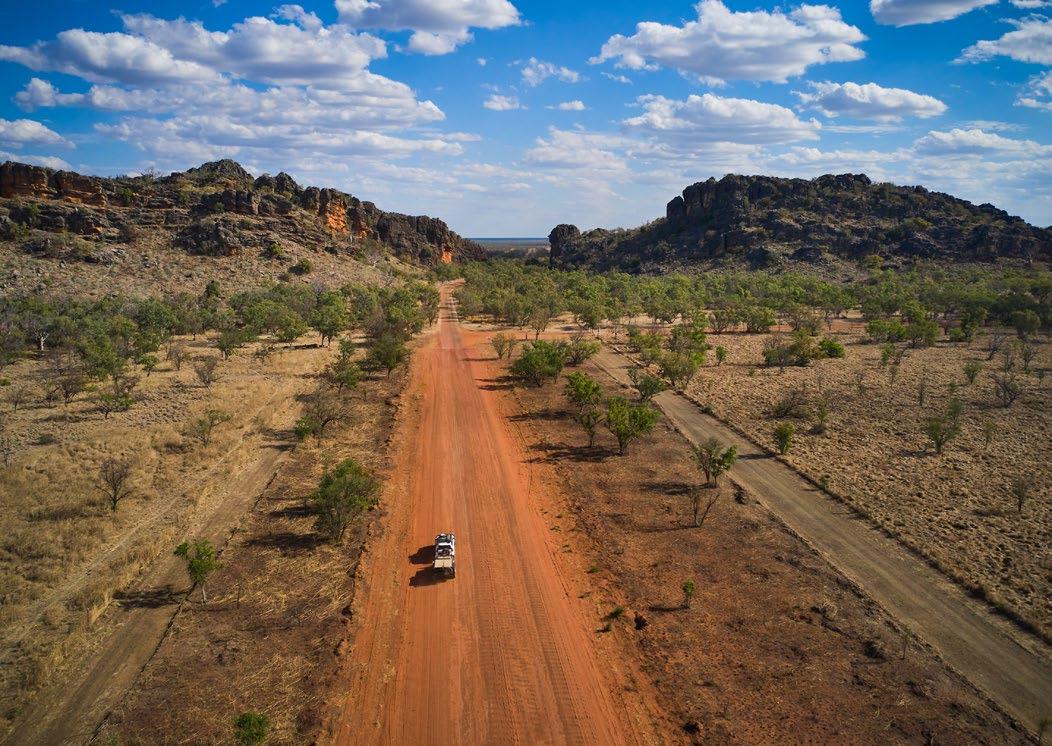
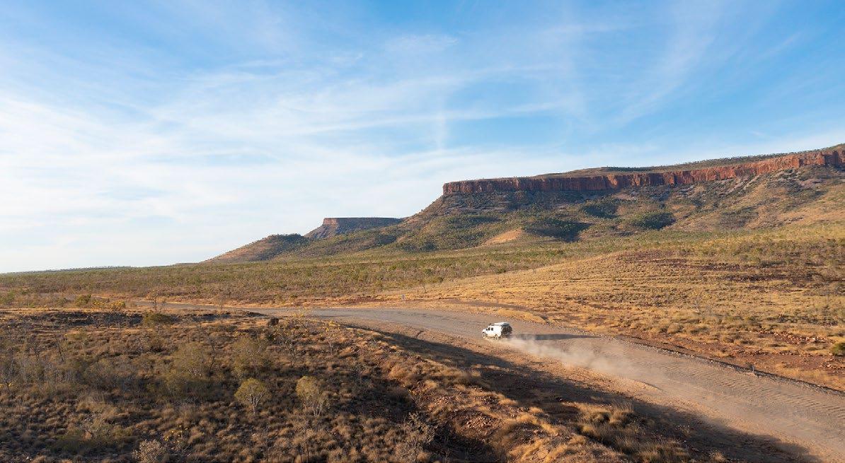
The Gibb River Road, or “The Gibb” as it is referred to is an iconic bush drive that stretches from near Wyndham across to the township of Derby. This iconic drive is home to a myriad of gorges including the famous Emma Gorge and El Questro where visitors flock in the thousands each year.
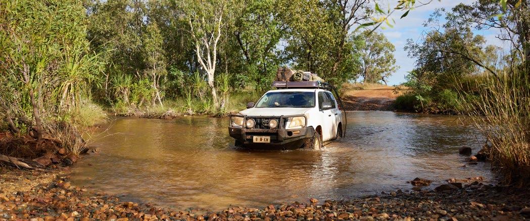
Travelling a direct route, the 660 kilometre road is mostly unsealed. A dream for four-wheel drivers wanting to avoid the Great Northern Highway and see the vast landscape of the Kimberley.
Some of the most beautiful waterways and gorges can be seen on The Gibb and one of the reasons that this is so revered is that visitors can discover natural flora and fauna not found in other parts of Australia.
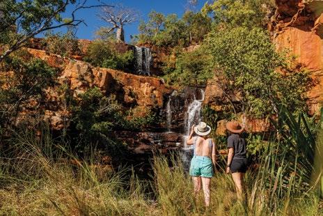
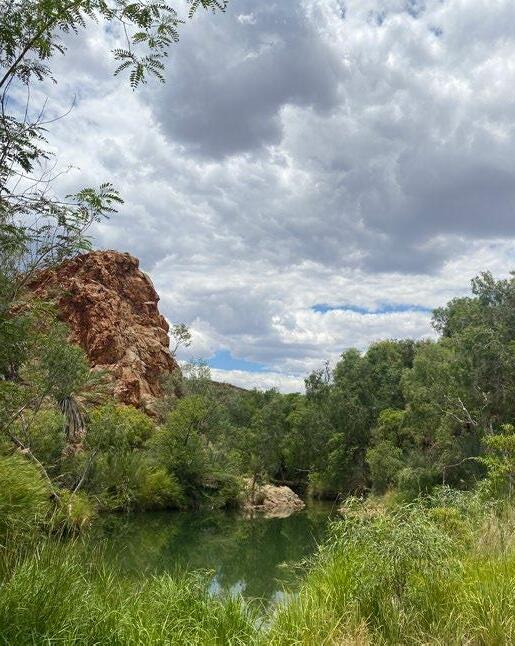
Galvans Gorge, right in the heart of the Gibb River Road, is one of many gorges in the area. It’s a tranquil stop-off and a nice place to cool down and have a swim. Fourteen kilometres west of the Mt Barnett Roadhouse and just one kilometre off the road, it’s not too far out of the way to stop for a rest and explore the area.
Another gorge near Galvans is the Manning Gorge, on the Mt Barnett Station. Only seven kilometres from the roadhouse, it’s worth the short trip out.
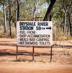
Supplies along the Gibb River Road can be picked up at Drysdale River Station and which is approximately 60km north of the junction on the way to Mitchell Plateau but it is recommended to cart good supplies with you if you are taking the journey across the Gibb. Food and supplies are shipped in and out regularly, but consistency is varied and not everything is readily available.
Home to both Freshwater and Saltwater crocodiles, this part of Australia houses many reptiles. Lizards and snakes are common throughout the Kimberley Region.
The Gibb River will get you as close as you can get to these ancient creatures. It’s wise to keep a distance from them though. Birdwatching is the sole reason that many visitors travel this region. With over 300 different bird species throughout the Kimberley it’s no wonder why.

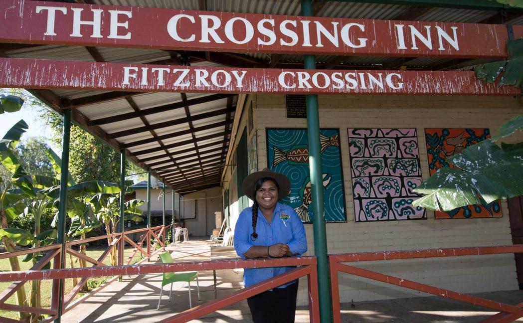
When driving into Fitzroy Crossing, the town may seem quiet, but if you’re given the opportunity, it’s worth stopping to have a look around.
Sites include the ancient rock art of the Gooniyandi in the Mimbi Caves which display some of the oldest rock art in the region, dating back approximately 40,000 years. Visitors can also explore the Geikie Gorge National Park, which features stunning gorges and sandstone cliffs that over millions of years have been shaped by the Fitzroy River.
The nearby Tunnel Creek National Park offers visitors the chance to explore an underground cave system that was once used as a hideout by the famous outlaw, Jandamarra who fought for the land. To the European settlers, he was an outlaw to be hunted. To the Bunuba people, he was a courageous defender of his country.
The first settlement of Fitzroy Crossing commenced in the 1880s and soon thereafter, Margaret Downs was established by Solomon Emanuel, a local pioneer who migrated from England. Solomon Emanuel played a huge role in the early development of Fitzroy Crossing and Margaret Downs, using his resources to develop infrastructure.
Margaret Downs is now known as Gogo Station and is just a short distance out of town.
Fitzroy Crossing is a town that in the scheme of things is fairly young. During the second half of the 1960s in the midst of the emergence of the pastoral award and equal wages, the majority of people walked off the cattle station which made Fitzroy Crossing the town it is currently. Today, the town embraces the Indigenous history and culture of the region and when you pass through the town, the entire place is a step back in time. Throughout the Fitzroy Valley there are over 40 Aboriginal Communities and five different languages; Bunuba, Gooniyanda, Walmajarri, Nyikina and Wangkatjunka.
Each of the five languages cover large tracts of the Fitzroy Valley; from the Bunuba people north of the Fitzroy River, to the Walmajarri and Wangkatjunka of the Great Sandy Desert. West of the Bunuba lands belongs to the Nyikina people.
The Gooniyanda people are from the southern side of the Fitzroy River, with their land stretching all the way from Fitzroy Crossing past Margaret River.
One of the largest rivers in Australia, the Fitzroy River has a basin size of roughly 90,000 square kilometres. The enormous expanse of the river makes it a hub for wildlife and unique flora, all of which comes together to showcase the rich cultural significance of the area.
Much like the Purnululu National Park in the Eastern Kimberley region, the Fitzroy River is a sacred and protected cultural site for this area. The river brings life and gives life to generations of living creatures. Saw Fish, River Sharks, Crocodiles inhabit the streams, along with other species.

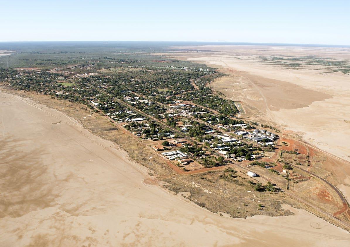
Halls Creek is located between the towns of Fitzroy Crossing and Turkey Creek on the Great Northern Highway. Halls Creek is closest to Purnululu National Park, and closest to the turn off to Wolfe Creek National Park.
Although a tiny town that most people pass through, there is some historical significance with Halls Creek, the home of a goldrush of the late 1800’s which peaked in 1886 when it was agreed that the area didn’t hold large deposits of gold.
The town was originally located approximately 15 kms out of town on the Duncan Road which eventually joins into the Buntine Highway as it branches into the Northern Territory.
For serious 4 wheel drivers, this stretch of road provides the ultimate adventure and it is possible to travel the road and come around the back of Lake Argyle.
There are some short term camping spots on the way, but travellers need to be prepared, carrying good water, fuel, two spare tyres and plenty of food.
Just 5km out of Halls Creek is the famous China Wall, which showcases an amazing display of nature’s magic as quartz stone blocks rise into a long, single wall that stretches 15 kilometres.
The wall was created over thousands of years as the land eroded and left the vein of hard stone standing in what appears as a man made wall of mostly rectangular rocks.
The signage at the turnoff for China Wall is not hugely prominent so check your odometer on the way out and if you get to the old town, you have gone too far.
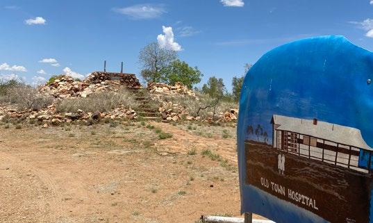
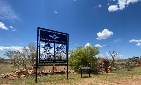
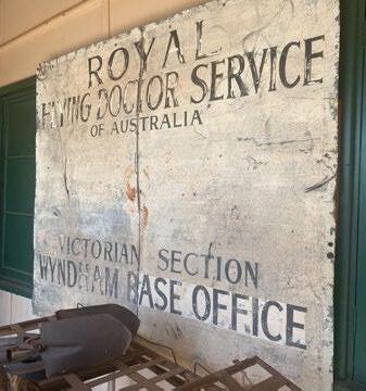
A little further out from China Wall and you will find the old Halls Creek Township which although mostly ruins now, is a really interesting example of past and prosperous times where you will see the location of the various stores and the Royal Flying Doctor Service Memorial which is a mustsee for visitors travelling the region.
On the Black Elvire River, Sawpit Gorge is a popular swimming destination during the dry season and where visitors will enjoy the incredible wildlife and landscape.
It’s recommended from June onwards not to swim as the water becomes stagnant but when it is flowing, it is indeed a sight to behold.
Swimming at Palm Springs in the freshwater pool is highly recommended for tourists visiting Halls Creek to cool off in after the harsh, outback heat. When visiting the area whether you’re swimming, hiking or just stopping for lunch, always take precautions and keep an eye out for snakes. Especially in and around the long grass at the water’s edge.
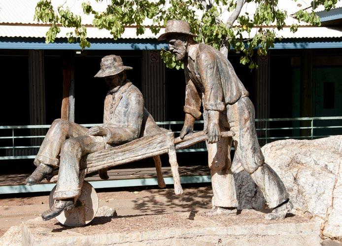
If you are passing through Halls Creek make sure you stop by Russian Jack which is a statue in testament to the lifesaving work of one of the local miners who carried his injured friend on a wheel barrow to Wyndham, a distance of over 300 kilometres, to receive medical help.
Russian Jack was the nickname of Russian-born prospector, Ivan Fredericks who worked in the Kimberley region during the late 19th century. In 1885, his friend, a fellow prospector, was seriously injured in a mining accident and needed urgent medical attention. With no hospitals or doctors nearby, Ivan decided to take matters into his own hands and set out on foot using a wheelbarrow to carry his friend.
The journey was gruelling, through rough terrain, extreme weather conditions and dangerous river crossings. They survived by eating bush tucker and drinking water from rivers and creeks. After 10 weeks of travel, they arrived in Wyndham, where they received the medical treatment needed to survive.
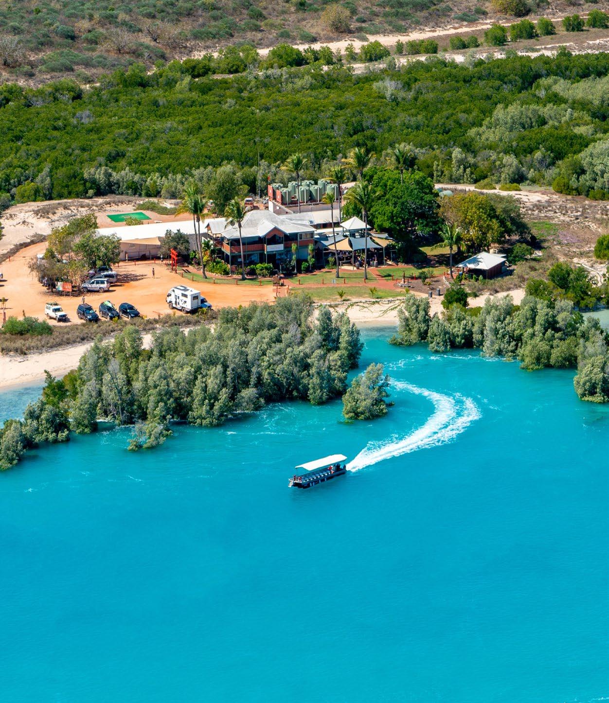
From Kununurra, or Wyndham visitors can travel in a relatively short period of time to the El Questro Station which is open between March and October each year.
El Questro was originally established as a cattle station in 1903 under pastoral lease. The lease changed hands many times and the name El Questro was eventually penned by Kimberley stockman Torrance McMicking who pegged the claim in 1958.
This famous landmark is visited by scores of visitors every year by land and air and if you are planning a drive along the Gibb River Road, if you are visiting Kununurra or just roaming the Kimberley then El Questro is likely to be on your to do list.
From Kununurra, or Wyndham visitors can travel in a relatively short period of time to the El Questro Station by road, but it is also very common for travellers to fly in on a chopper or small aircraft and although most flights are from Kununurra, trips from Broome are also available.
There are several operators offering flight services, so it pays to shop around.
El Questro operates twice-daily scheduled road transfers from Kununurra airport as well as from accommodation providers in the town centre.
Rates for scheduled road transfers from Kununurra to El Questro or vice versa are:
Kununurra to El Questro, Emma Gorge or vice versa $125 pp (45 minutes)
Kununurra to El Questro Station or vice versa $145 pp (90 minutes)
Kununurra to El Questo Homestead or vice versa $150 pp (110 minutes)
Rates are per person for each direction travelling. All road transfers must be pre-booked.
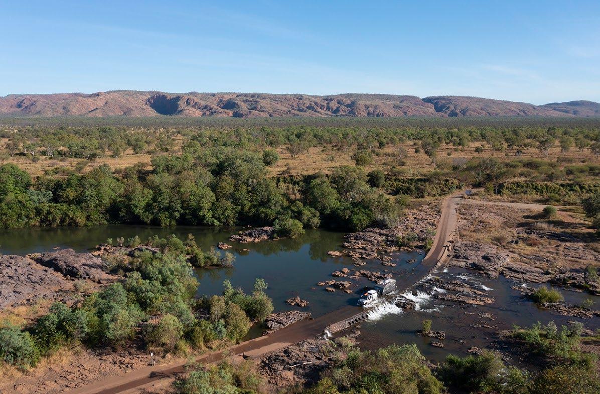
If you are driving, remember that access is by 4WD only and you will definitely be required to cross at least one river on your way in at Pentecost River. Although not deep, Pentecost should be crossed using a larger 4WD vehicle, rather than a standard SUV.
It is possible (but not recommended) to park your car at the river in the dry season and wade through the water across to the resort if your access methods are limited, but remember that you will need to cart your luggage across while you walk through knee-deep water.
If you are planning a trip to El Questro it is wise to call ahead and ask about entry conditions as things here change quickly and it is always wise to plan as best you can. Call El Questro Wilderness Park on (08) 7210 9600.
Entry to the park requires a permit. Prices are $26 per adult and $13 per child aged 3-16 years and valid for 7 days. Alternatively, day passes can be purchased for $12 per adult and $8 per child. El Questro Visitor Permits will be automatically added during the online booking process. If you are doing a day trip at El Questro, you may purchase the Visitor Permits at reception on the day.
Visitors generally spend between 4 to 7 nights at El Questro where there are drives to Branko’s Lookout, Pigeon Hole Lookout and Emma Gorge as well as a multitude of walks. It is a good idea
to plan no more than one walk a day, because conditions here can be very hot and medical services are limited.
Some good swimming can be had at El Questro Gorge but for visitors planning on doing the river crossing here, remember that you will need a snorkel on your vehicle.
There are several accommodation options for visitors to El Questro, from the Emma Gorge Resort where guests are able to enjoy tented cabins which are powered and have a few creature comforts, the Gidday Park at The Station, the Wyndham Caravan Park, Diggers Rest Station and Parry’s Caravan Park.
Home Valley Station, located approximately one and a half hours away is another place visitors can stop and explore the region from. Also known as Balanggarra Station, it is situated between the Pentecost and Gibb Rivers and its location makes it a must do for travellers. The station is under management by the Traditional Landowners and its deep cultural connection gives visitors a chance to really immerge themselves in the deep history and significance of the area.
There are good restaurants and eating facilities at Emma Gorge and El Questro and also at Home Valley Station.
From May through to the beginning of October, El Questro very rarely gets rain and enjoys warm, sunny days. The winter months of June, July and August see daytime temperatures between the high 20’s and low 30’s and the nights cool off to between 8 and 18 degrees Celsius.
April, May, September and October have warmer temperatures all around, when daytime highs can be in excess of 35 degrees Celsius and night time lows are between 15 and 25 degrees Celsius. April and October can be particularly humid with some chance of rain.
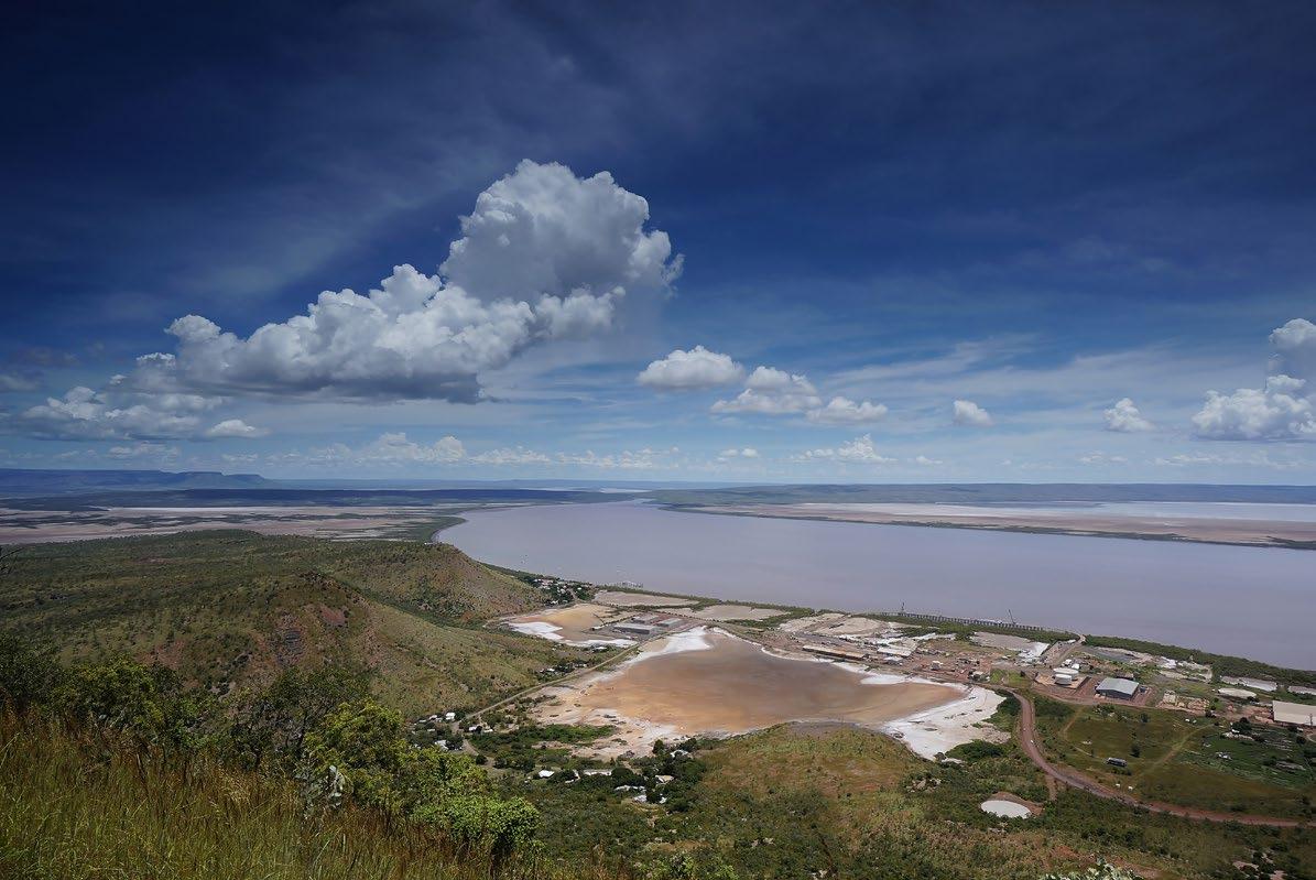
Although now a quiet out-of-the-way place, the town of Wyndham was once a bustling town where cattle were brought for export to the rest of the world.
European settlers began to arrive in 1884, after thousands of years of Indigenous settlement. Bringing cattle and mining across East Kimberley, sparking the Kimberley gold rush and developing towns. Wyndham was developed within months, with businesses and six hotels opening.
Mining was huge in the area - a track was marked between Halls Creek and Wyndham, although many prospectors weren’t equipped for the harsh and dangerous conditions, resulting in a huge number of deaths due to exposure and exhaustion.
The Cambridge Gulf became an easily accessible port for transporting cattle south to Fremantle. In
1894, a jetty was built at Athon’s Landing making transporting cattle easier. The jetty at Athon’s Landing is now a great family fishing destination.
In the past, the meatworks (which opened in 1919) employed between 1,600 and 2,000 people and was the biggest meatworks in the southern hemisphere and occupied a massive part of the town.
Travel up to the Bastion at Five Rivers Lookout and you can see the current township, but you will also be able to get a sense of the old times as you compare the historical meatworks site against the modern-day town layout.
In the dry season, travellers often tend to skip Wyndham, assuming that there is nothing to see in this peaceful hamlet. However, Wyndham is extremely interesting and offers a great base for travelling around this part of the Kimberley.
The Wyndham Museum is a fantastic and mustsee place to visit. Although open most days, you may need to call the phone number on the door to get in if the caretaker isn’t there.
Things are slow in Wyndham and although always accommodating, don’t expect local operators to be in a rush. People here love a chat and make visitors slow down and enjoy the pace of this historical location.
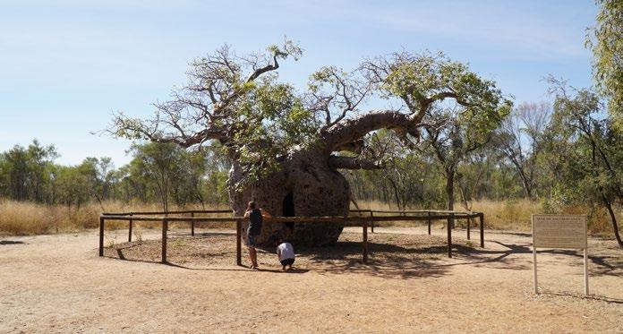
Be sure to head out to the Prison Tree which is 31km from town. As with the town of Derby and Timber Creek (NT), aboriginal prisoners were incarcerated here in the old times, and tied up to a large Boab tree, where they would be left for hours without food and water. This cruel practice remains an horrific fact of the colonial past.
Head to Parry Creek Caravan Park and ask about doing a Parry Lagoons Nature Reserve walk with one of the local guides. This amazing area is a sight to behold and is the home to a magnificent array of birdlife. In the wet season, thousands of magpie geese cover the area, but it is also common to see other varied species including brolgas, herons, spoonbills and more.
For bird watchers the Gouldian Finch is found here in Wyndham. The Gouldian Finch, also known as the Rainbow Finch or scientifically as Erythrura Gouldiae, is a small bird species, native to the Kimberley region. With a strikingly colourful plumage, males display bright green, blue and purple on their heads, while females tend to have more subdued colours. The bird’s nest in the hollows of eucalypts trees or
sometimes holes in termite mounds and can be found throughout the savanna woodlands.
This rare species have become endangered due to the threats from human introduced animals that destroy the grasses these birds rely on for food. Although once numbering in the millions across northern Australia, the species has declined to just a few thousand. Although these birds are difficult to breed, when they do finally find their partners, they mate for life. The beautiful colours and patterns on these birds make them one of the most stunning Australian birds.
Must do activities in Wyndham include a visit to the Museum, a drive up to Five Rivers Lookout, the Warriu Dreamtime Statues, the Afghan Cemetery, Parry Lagoons Conservation Park.
For travellers who enjoy fishing; Wyndham has some of the best fishing in Australia. Along the King River, towards Diggers Rest, there’s great opportunities to sit back and cast out before continuing a 4WD adventure. In Wyndham, all year round there’s a good chance of catching some beautiful saltwater Barramundi, especially during the warmer times of year (September to May).
Make sure to see Diggers Rest Station but check first as it is closed at various times of the year.
For war historians, the site of the MV Koolama site buried deep in the mud just a short distance from the Wydham jetty is a fascinating story of courage and determination.
The Koolama was a vessel that departed Fremantle in 1942, bound for Darwin and loaded with passengers, soldiers, army trucks, equipment, guns and a cannon when it was attacked by the Japanese in the Timor Sea. Although badly damaged, the ship made it to what is known today as Koolama Bay, located around 200km north west of Wyndham as the crow flies.
Koolama Bay lies at the mouth of the King George River and although the MV Koolama was badly damaged after the attack, it was able to be anchored closely enough to shore that passengers were able to find fresh water and make camp until help arrived.
Remarkably the MV Koolama was then sailed to Wyndham Harbour through the hard work of the remaining crew and volunteers. Sadly however, the town of Wyndham was attacked shortly after the ships arrival and she capsized just two weeks after the initial attack. Tragically, 100 lives were lost in the incident.
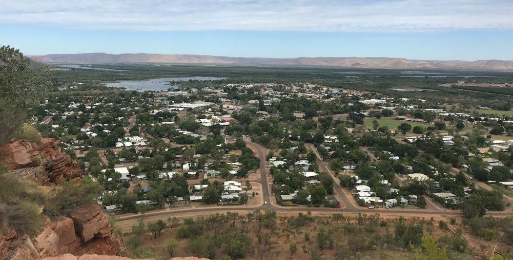
Kununurra is the perfect base from which to explore rugged landscapes, pristine lakes and waterfalls, and other incredible landmarks in the east Kimberley region.
Located just over 800 kilometres from Darwin, Kununurra has a transient population that ranges from 7,500 to more than 14,000 during the dry season. Surrounded by some of the most stunning natural landscapes in Australia, you won’t be disappointed by the array of activities and attractions the region has to offer.
The Traditonal Owners of Kununurra are the Miriwoong Gajerrong people. Not surprisingly, the name of the township comes from the local Aboriginal word for river, “Goonoonoorrang”. The region is steeped in Indigenous heritage, from awe-inspiring rock art to modern paintings that illuminate Aborginal culture and narratives.
To read the Ngarranggarni Barramundi Dreaming Story, visit gelganyem.com.au and go to ‘Our Story’.
Boasting so many natural wonders, Kununurra provides the perfect base to explore the incredible East Kimberley region and your gateway to the eastern end of the Gibb River Road. Experience breathtaking waterfalls such as Mitchell Falls and unique topographical landmarks such as the Bungle Bungle Range. While Lake Argyle was a man-made venture, it has given rise to a thriving natural eco-system full of native fauna.
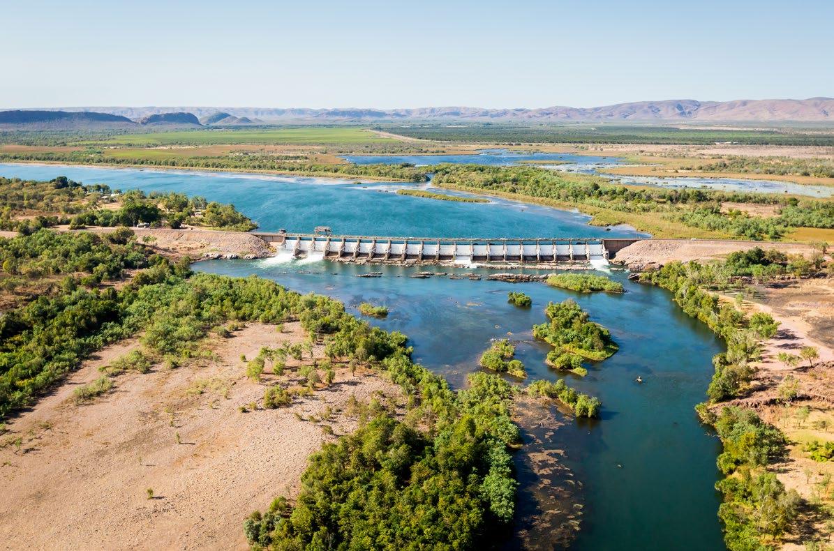
Check out the Ord River Diversion Dam which is one of Kununurra’s most famous landmarks. The dam wall is 335m wide and plays a big part in controlling the flow of water for the irrigation of crops in the area.


The region is renowned for its beautiful lakes and waterways. Enjoy a dip in one of the serene and replenishing rock pools.
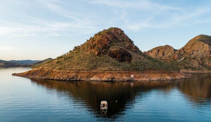
Lake Argyle, known as the ‘Jewel of the Kimberley’, is a remarkable man-made lake that provides an array of activities and attractions for visitors to the region. This flourishing eco-system supports over 270 species of birds, 26 species of native fish and an abundance of other fauna such as the Short Eared Rock Wallaby. Lake Argyle is the perfect place for fishing, swimming, canoeing, spotting wildlife, cruising on the lake and exploring the region on foot.
The Ord River is a pristine waterway that offers plenty of opportunity to spot the local wildlife and fauna. Take a 55km cruise down the river to beautiful Lake Argyle. Spot some freshwater croc’s along the way.
A place for keen anglers to try their hand at barramundi fishing. The lake also offers great birdwatching opportunities as well as a range of watersports such as canoeing, rowing and waterskiing. Kick back and relax on a beautiful sunset cruise along the lake.
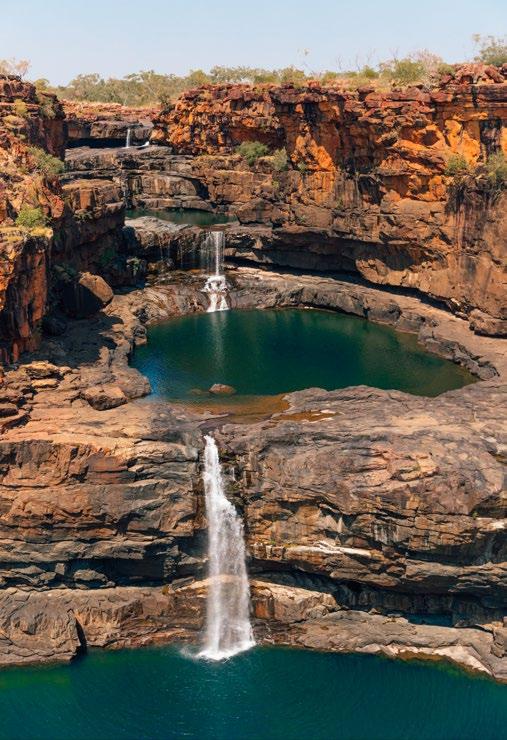
Experience the spectacular Mitchell Falls firsthand to see why this four-tiered waterfall is a favourite amongst tourists. Be sure to take a Mitchell Falls tour that includes a scenic transfer and guided walk to view the falls and Aboriginal rock art. Although swimming is not permitted beneath the falls, you can enjoy a dip in the pools above. The challenging 4.3km trek is well worth the effort!
Located approximately 70kms from Kununurra on the way to Wyndham, The Grotto is an amazing waterfall during the wet season. Visitors can venture down the 140 steps that lead to a lovely rock pool. Wear sturdy shoes and be careful on the path down and up as there is no rail. The pool is a safe, refreshing spot to cool off.
Just a short 4WD from Kununurra, Black Rock Falls is a beautiful feat of nature after the wet. It’s the perfect spot to enjoy a refreshing dip and picnic.
Please note that both estuarine and freshwater crocodiles inhabit the Kimberley region.
For more information on being CROCWISE, visit www.parksandwildlife.nt.gov.au
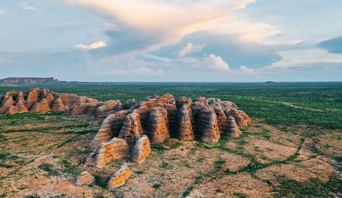
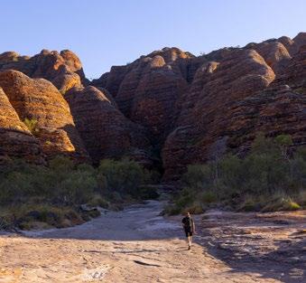
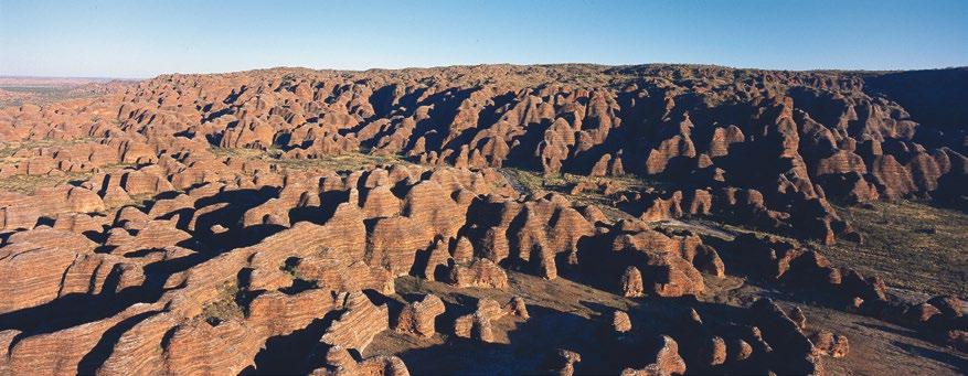
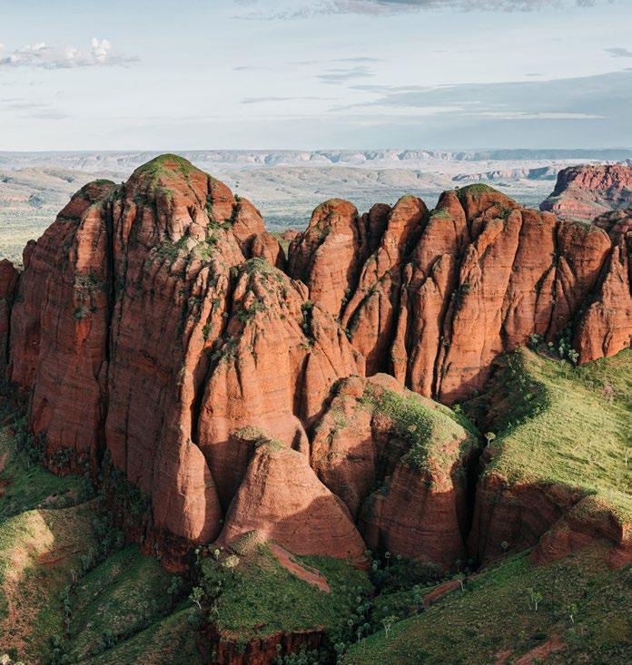
Located in Purnululu National Park World Heritage area, the Bungle Bungles (or as locals call them “the Bungles”) rate amongst one of the most sought after sights to see in Australia, alongside the Great Barrier Reef, Uluru and the Great Ocean Road.
Although large numbers of people fly to the Bungles, it is possible to drive there if you are an experienced four-wheel-driver. The turn off is roughly 100 kilometres north east of Halls Creek along the Great Northern Highway and can be spotted by the information bay at the intersection.
There is free camping with good facilities at Spring Creek 24 hour camp but there is also paid caravanning at the Bungle Bungles Caravan Park where vans can be stored for visitors planning on going further to camp.
The nature here is simply amazing, with ancient rock formations including the Cathedral Gorge which is a 4 kilometre round trip walk where you will pass through the Beehive walk, a stunning rock formation which is unique to this part of the world.
The roads in and out of Purnululu are subject to extreme conditions so always check before driving to the area.
Flights to the Bungles are regular but very busy in the season, so if you are planning a flight to the area then be sure to book early. There are operators flying from Broome, Halls Creek and Kununurra to the Bungles and if you are in the Kimberley a visit to the region is a must do.
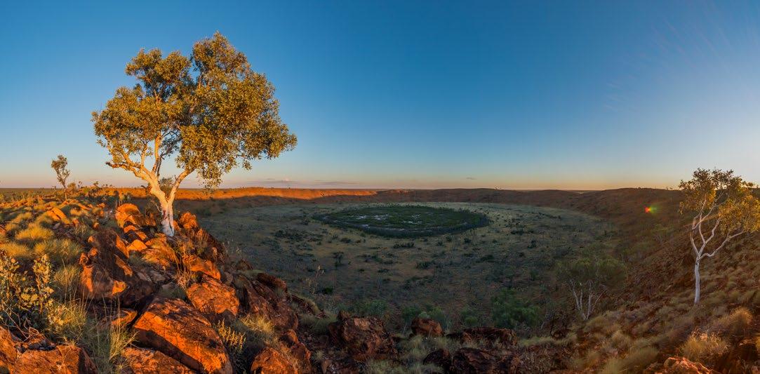
A significant cultural icon for the Walmajarri people for thousands of years, the Wolfe Creek Crater is a must-see for visitors travelling to the Kimberley. The Wolfe Creek Crater is the world’s second largest crater formed some 300,000 years ago when a massive meteor collided with the earth. The crater was created in just a few minutes, but the impact left a marked legacy which is revered and respected to this day.
Recognised by the modern world in 1947, the Walmajarri believe this amazing sight was created when a rainbow serpent fell into the crater. This particular group of locals share song paying respect to the site and to the significance of its history.

Although located only about 148 kilometres out of Halls Creek, it takes about four hours to get to the Crater because the roads are rough and should only be accessed by 4WD or by air.
Wolfe Creek Crater can be accessed through a scenic flight or by road. For flights, contact Northwest Regional Airlines in Halls Creek or Shoal Air www.shoalair.com
If you are driving from Halls Creek, travel west along the Great Northern Highway for 18 kilometres and turn onto the Tanami Road towards Alice Springs. You need to travel another 112 kilometres to the park turn off which is well signposted and then its only a relatively short distance to the park.
The walk is amazing and is only about 400 metres, and definitely worth it. The birdlife, the vastness and the silence is breathtaking and a visit will leave a memory that will last a lifetime.
Be sure you have adequate fuel and supplies for the round trip, including fuel, water and some snacks. Travel outside the dry period (May to October) is not recommended.


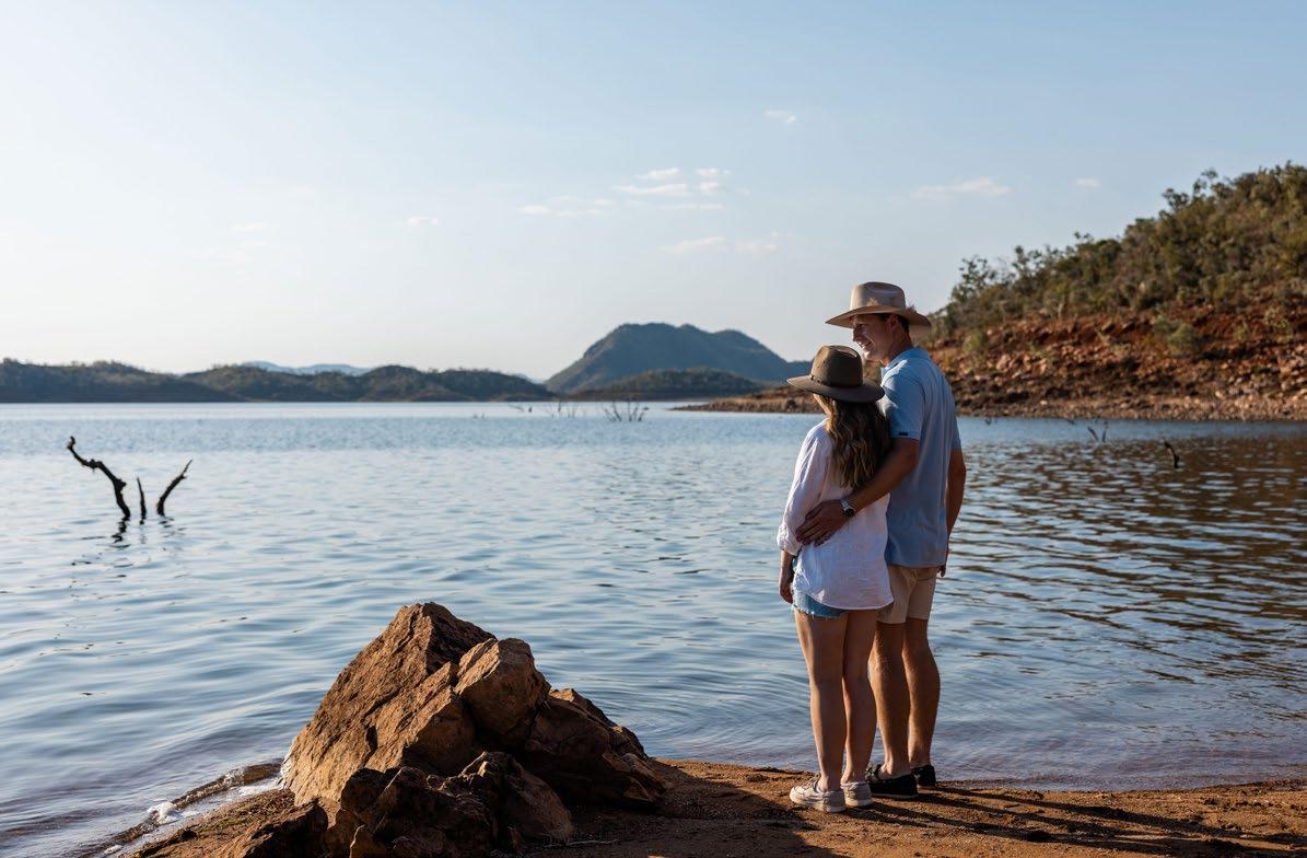
Lake Argyle, known as the ‘Jewel of the Kimberley’, is a remarkable manmade lake which is 21 times the size of Sydney Harbour and provides an array of activities and attractions for visitors to the region.
This flourishing eco-system supports over 270 species of birds, 26 species of native fish and an abundance of other fauna such as the Short Eared Rock Wallaby.
Lake Argyle is for fishing, swimming, canoeing, spotting wildlife, cruising on the lake and exploring the region on foot and can be accessed through a self-tour, or with one of the operators who offer services mainly from Kununurra.
The drive to Lake Argyle is very easy, on sealed road the entire way and you can drive it from Kununurra or coming in from Timber Creek. The turnoff is 35 kilometres out of Kununurra and the drive to Lake Argyle is the same distance. Be mindful of cattle and other wandering animals when you take the drive which will treat you to some of the most beautiful landscape in the world.
Operators such as Triple J Tours out of Kununurra offer luxury coach services which are fully catered for, but for travellers looking for a more cultural experience, there are companies such as Silent Tours and Luridgii Aboriginal Eco Tours. The owner of Luridgii, Ted Hall is a legend in the area and although very difficult to book due to popularity, it’s worth persevering or even returning for as you won’t be disappointed.
Be sure to go to the Kununurra Visitor Centre before heading down to Lake Argyle, because the area is quite remote and being informed before you leave will give you a more full experience.
Located a short two kilometres from Kununurra, the Mirima National Park is one of the easiest ways to experience nature in the region. The local Miriwoong people have a special connection to the park and you only have to venture there to see why.
The park boasts four walking trails which provide the opportunity to marvel at uniquely-contoured landscapes and native wildlife while taking plenty of great photos. Unlike some areas in the East Kimberley, the Mirima National Park is accessible to visitors all year round.
Showcasing an amazing display of nature’s magic, naturally formed, quartz stone blocks rise into a long, single wall that stretches 15 kilometres.
The wall was created over thousands of years as the land eroded and left the vein of hard stone standing in what appears as a man-made wall of mostly rectangular rocks.
This is the home of the Jaru people and the local name for this amazing structure is Baraluba.
Only 5 kilometres out of Halls Creek, visitors can view the site from their vehicles and it can be accessed by either 2WD or 4WD vehicles.
Be sure to shut the gate as you enter and exit the turn off.
Enjoy an iridescent Kununurra sunset from Kelly’s Knob. Located a short distance from town, this is a popular natural attraction that provides sweeping vistas of the township, Mirima National Park and Sleeping Budha. Drive to the top or take the 1.2km hike up and back. Be aware that parking spots are sometimes limited.
DUNCAN
With diverse and spectacular scenery the Duncan Road truly is a well kept secret waiting to be explored.
This 429km gravel road between Halls Creek and Kununurra snakes back and forth several times across the Western Australian and Northern Territory border, re-joining the Great Northern Highway to the east of Lake Argyle. It offers spectacular outback scenery. The Duncan can be rough and is subject to flooding. Please check road conditions in advance of travel. A 4WD vehicle is recommended. Places to visit along the Duncan Road within 50 kilometres of Halls Creek include China Wall, Caroline Pool, Old Stone Hut, Old Halls Creek, Pioneer Cemeteries, Palm Springs and Sawpit Gorge. Further out you can visit Ringer Soak (Kundat Djaru) community and Yaruman Art and Culture Centre, Marella Gorge, and camp alongside some gorgeous creeks and rivers.

Sleeping Buddha has earned its quirky moniker because, depending on your vantage point, this rocky outcrop looks like a slumbering Buddha. For the perfect angle, view this iconic attraction from Celebrity Tree Park. From other angles, the rock is reminiscent of an elephant’s head. And not to confuse you, it’s official name is Carlton Ridge!
Lying about 70kms south of Kununurra, the stunning Ragged Range are rarely photographed. Not visible from the main road that leads to the more famous Bungle Bungles, Ragged Range is a spectacular afternoon landscape shoot.
Stretching across a section of the Gibb River Road, the Cockburn Range comprises of spectacular sandstone cliffs that look like a wall fortifying the horizon. The cliffs are particularly majestic at sunset. Located in El Questro Wilderness Park, tours through the Cockburn Range can be organised via the park.
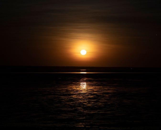
Huge gorges, stunning landscapes and vast expanses are all part of the experience in Broome. But the magic doesn’t end on terra firma. Between March and October every year, you will see something very special – the Staircase to the Moon.
When the tides at Roebuck Bay are very low and the full moon rises, the reflection on the exposed mudflats give the very real illusion of a staircase to the moon. This wonderful delight occurs two to three days a month between March and October. Usually on one evening of the Staircase to the Moon, the Town Beach precinct plays host to an evening market, with live music and this creates excitement as the community and visitors gather to wait for the moon to rise.
For the best views, head to Town Beach, The Mangrove Hotel Resort, the Broome Golf Club, Roebuck Bay lookout, or Matso’s Broome. Cygnet Bay, north of Broome, also provides excellent viewing spots.
For dates and times visit www.visitbroome.com. au/info/staircase-to-the-moon-dates
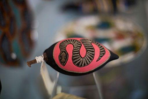
The Kimberley region abounds with culture, ancient history and an appreciation of life that goes beyond money and possessions.
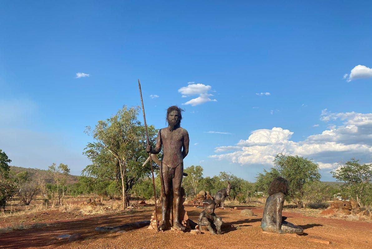
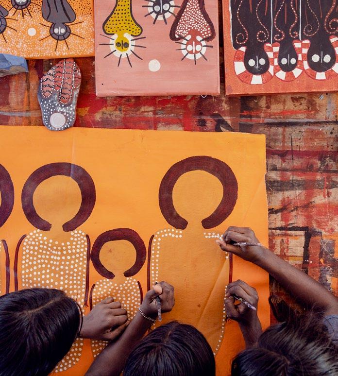
The Kimberley region is a vast and ancient land where Aboriginal culture has thrived for tens of thousands of years. This rich heritage is woven into the very fabric of the landscape, from the rugged coastline and deep gorges to the expansive deserts and flowing rivers. Today, over 30 Aboriginal tribes call the Kimberley home, each preserving its own language, stories, and cultural practices.
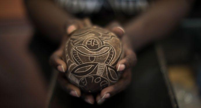
Among the most significant cultural treasures in the Kimberley are the Bradshaw Paintings, or Gwion Gwion, which are believed to be at least 17,000 years old. These intricate rock art images offer a fascinating glimpse into a vibrant and enduring culture, showcasing the deep connection between the people and their land. The region also boasts evidence of Aboriginal habitation dating back over 40,000 years, making it one of the longest continuously inhabited areas on Earth.
The Wanjina-Wunggurr homeland is particularly rich in cultural significance. Here, the Wanjina creator beings, manifested in rock art figures, stone arrangements and landscape features, are central to the laws and customs of the people, guiding every aspect of their lives. The rock art of this region, which includes images of ancestors, plants, animals, and spiritual beings, is among the longest and most complex sequences in
the world. These paintings not only serve as a visual record of ancient traditions but also reflect the ongoing connection between the people and their environment.
In the East Kimberley, this deep cultural heritage continues to thrive through artistic expression. Local artisans create unique works such as Boab seed carvings, intricate paintings, and traditional foods that draw on ancient knowledge. Visitors can experience this living culture firsthand by visiting places like Wyndham, where Jaru woman Bianca Long from Jaru Girl, shares insights into how ancient traditions coexist with the modern world. In Kununurra, chef Temali Howard at Blak Tapas blends bush culture with global culinary influences, offering a taste of the region’s rich heritage.
A journey through the Kimberley is not just about exploring stunning landscapes; it’s an immersion into one of the world’s oldest living cultures. Whether through the ancient rock art, the traditions of the local tribes, or modern expressions of cultural pride, the Kimberley offers a deep and enriching experience that connects visitors to the timeless spirit of this remarkable region.


BROOME HISTORICAL MUSEUM
Broome
Packed to the rafters with vintage and historical items and all for a small entry fee (children under 16 are free). The museum will appeal to visitors of all ages and lets you step back in time, be engaged and educated as you browse the carefully curated displays. This significant collection is spread across three buildings, including the heritage award winning Sailmaker’s Shed. broomemuseum.org.au
BROOME GALLERY
Broome
Broome Gallery is the home of contemporary Kimberley Artist James Down. His vivid artworks feature the brilliant colours of Broome and the Kimberley in a whimsical style. www.broomegallery.com.au
Broome
Black Stump Gallery is dedicated to showcasing artworks and gifts from local artists inspired by the Western Australian regional landscapes. blackstumpgallery.com.au
NAGULA JARNDU DESIGNS
Broome
Specialising in textiles, every piece of work is an original, and there is something to meet everyone’s budget. High end designs on quality base fabrics, linens, silks and cottons for the textile lovers, and many other original pieces for delightful gifts. The artists are always happy to have visitors, so come to Nagula Jarndu studios and meet the women working and enjoy the beautiful fabrics they are producing. www.nagulajarndu.com.au
BROOME TIME ART GALLERY
Broome
A wide variety of Kimberley Art Broome Time Art Gallery features a wide variety of Kimberley art, traditional & contemporary Indigenous paintings & artefacts, wood & boab nut carvings, hand crafted didgeridoos, books & gifts. www.facebook.com/broometimegallery
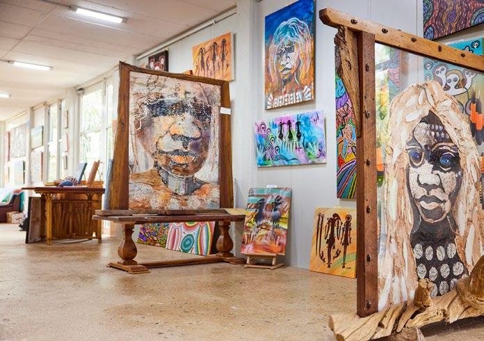
MOWANJUM ART & CULTURAL CENTRE
Derby
TThe Mowanjum Aboriginal Art and Culture Centre is a creative hub for the Worrorra, Ngarinyin, and Wunumbal tribes who make up the Mowanjum community outside of Derby. The centre showcases art which is created by talented local artists where visitors can interact with Indigenous art and culture through video, carvings, and wall art. The centre hosts exhibitions, workshops and community projects, as well as the annual Mowanjum Festival, one of Australia’s longest running Indigenous cultural festivals.
mowanjumarts.com
NORVAL GALLERY
Derby
Renowned local artist Mark Norval is considered one of the most notable artists in Derby. Responsible for his amazing sculptures on display around the town, the gallery is located just opposite the information centre and showcases a wonderful display of art.
www.facebook.com/NorvalGalleryDerby
WINUN NGARI
Derby
Screen printed clothing and local pieces are created here by local women. The centre was developed as a local facility for Indigenous women where they are encouraged to bring to life creative ideas and fantastic designs. www.winunngari.org.au/time-to-work
MANGKAJA ARTS RESOURCE AGENCY
Fitzroy Crossing
The art centre is located in the centre of Fitzroy Crossing and functions as a fine art gallery, specialty store and a studio space for the artists to paint and make cultural artefacts. www.mangkaja.com
YARLIYIL ART CENTRE
Halls Creek
This Indigenous owned gallery is a real eye opener for visitors who can call in and see local artists creating amazing paintings which share stories with visitors. While Yarliyil is not widely advertised, a visit here for anyone with an appreciation of art will leave a lasting memory. www.facebook.com/p/YarliyilArts-100064531668891/
ARTOPIA GALLERY
Kununurra
Showcasing the work of Kimberley artists across fine art, photography, sculpture and giftware. www.artopiagallery.com.au


ARTLANDISH ABORIGINAL ART GALLERY
Kununurra
Artlandish Aboriginal Art Gallery is home to a large collection of Indigenous works which showcase and support original art. www.artlandish.com
BIRDLAND FUNCTIONAL ART
Kununurra
This gallery boasts glassworks and pottery, and functional art pieces such as jewellery, hanging pots, wallets, tea sets, and much more. A great place to find a boutique gift or keepsake. www.facebook.com/BirdlandFunctionalArt
WARINGARRI ABORIGINAL ARTS
Kununurra
Preserving local Aboriginal culture, Waringarri Aboriginal Arts showcases natural ochre painting, sculptures and wood carvings from local Miriwoong artists. www.waringarriarts.com.au
KUNUNURRA MUSEUM
Kununurra
Calling all history buffs, the Kununurra Museum has memorabilia and ancient artefacts that pay tribute to the region’s long and fascinating history. www.kununurra.org.au
ARGYLE HOMESTEAD MUSEUM
Kununurra
Pay tribute to a pioneering history and one of the region’s foremost families at Argyle Homestead Museum. Explore the house owned by the local Durack family renowned for their pastoral feats in challenging weather conditions. The museum is open April to September. A nominal entry fee is required. argylehomesteadmuseum.com.au
THE CHIK SHED
Kununurra
Functional art, glass and pottery studio overlooking the Ord River. www.thechikshed.com.au
JARU GIRL
Wyndham
Indigenous fashion designer Bianca Long shows off fantastic designs and gorgeous clothing which has started to become famous in the fashion centres of Sydney and Melbourne. Here visitors can admire these unique designs or purchase from an amazing and unique array of designer fashion. www.jarugirl.com
WYNDHAM MUSEUM
Wyndham
The Wyndham Museum is located in the original 1954 Courthouse in the Historical Port Precinct. It houses some fascinating memorabilia, journal records and photographic displays of Wyndham since European settlement in the 1880s. www.facebook.com/p/WyndhamMuseum-100064530169120/
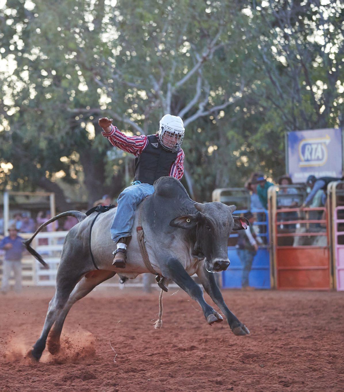
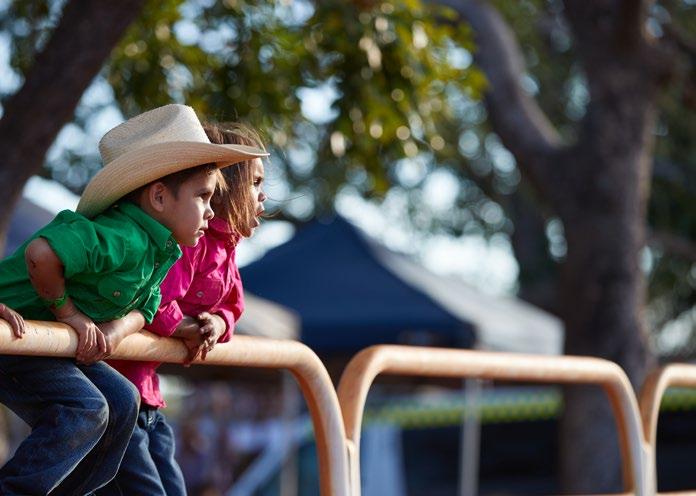
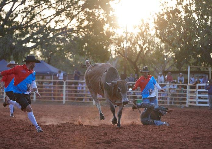
TOP END MUSTERING RODEO –ORD VALLEY MUSTER
May
The Top End Mustering Rodeo is a must-see event, featuring intense competition and big cash prizes. Watch local and interstate cowboys and cowgirls try to hang on for 8 thrilling seconds in saddle bronc, bull riding, barrel racing, and more. It’s a fun night out for the whole family with live entertainment, a fully licensed bar, and various food outlets.
Kununurra Rodeo Grounds, Victoria Hwy, Kununurra
FITZROY CROSSING ANNUAL CAMPDRAFT & RODEO
June
This true country, down to earth family event caters for all competitors, young or old, beginners or legends. An exciting 4 days showcasing local talent with campdrafting and the rodeo on Saturday and Sunday. Licensed bar area alongside the arena, live entertainment, and food vans.
Fitzroy Crossing showgrounds on Sandford Road
HALLS CREEK RODEO AND CAMPDRAFT
July
A full program of riding events including the steer, bull and bareback ride and camp drafting. Outback colt challenge exhibiting horse handling skills and kids enjoy a mini stampede gymkhana.
Halls Creek Rodeo Grounds, Duncan Road, Halls Creek
KUNUNURRA RODEO AND CAMPDRAFT
July
Non-stop rodeo action, bull riding, saddle bronc, barrel racing and more. Watch the cowboys try to ride the longest 8 seconds of their life. Held twice a year.
Kununurra Rodeo Grounds, Victoria Hwy, Kununurra
DERBY OUTBACK RODEO AND CAMPDRAFT
August
Enjoy a fun packed weekend full of thrills and spills! Events include Barrel racing, Roping, Bulls and Broncs and much more. Campdraft on Friday and Rodeo events Saturday and Sunday.
Derby Rodeo Grounds, Ashley Street, Derby
BROOME RODEO
August
Broome Rodeo Club brings all the excitement, action, thrills and spills of Kimberley rodeo in Broome for a two day rodeo and campdraft. A great day out for the whole family including food vans, live music and a fully licensed bar.
Broome Rodeo Club
KUNUNURRA MARKET
Held each Saturday morning, 8am to 12pm, from April to September.
Whitegum Park, Corner Coolibah Drive & Leichhardt Street.
BROOME COURTHOUSE MARKET
Saturday all year round and Sunday in the dry season (May to September)
Located at the corner of Hamersley and Frederick Streets.
BROOME STAIRCASE TO THE MOON MARKETS
Night markets - full moon nights May to October. 4pm to 8pm Town Beach Precinct
BROOME THURSDAY NIGHT MARKET
Every Thursday night from June to September. 4pm to 8pm. Town Beach Precinct on Hamersley Street.
For more information on the markets, visit www.broomemarkets.com.au
DERBY CWA COMMUNITY MARKETS
CWA Community Markets are held every Saturday from 8am to 12pm from February to December. Regular stalls include produce, food & drinks, plants and art & crafts.
Clarendon Street, next to the newsagent.
WYNDHAM BIG BOAB MARKETS
Every second Saturday at the from 8am to 12pm and a great chance to meet some of the locals and buy home-grown produce.
Wyndham Caravan Park on Baker Street.