

2021: A NEMO ODYSSEY | NEMO SPACE ARCHIVE

 This project responds to the impact of the modern space race by proposing an architecture that retrieves and recycles the excessive debris we have put out into the Earth’s orbit.
PROJECT 1 | 2001: A SPACE ODYSSEY | NINETEEN EIGHTY-FOUR

Project 1 of this year takes inspiration from the movie, 2001 a space odyssey by Stanley Kubrick and George Orwell’s 1984.

PROJECT 1 | SPACE DEBRIS FACILITATION
Informed by their dystopic narratives and sci-fi nature -

PROJECT 1 | SPACE DEBRIS FACILITATION
Project 1 explores the infrastructure needed to accommodate crashed satellites.

SPACE DEBRIS | MODERN DAY

 Just a few weeks ago, China’s Tianhe shuttle fell space and produced a large amount of debris that crashed into inhabited areas.

[ DAMAGE TO SATELLITE ]


SPACE DEBRIS | KESSLER SYNDROME
 RemoveDEBRIS Satellite European Commission [2018]
RemoveDEBRIS Satellite European Commission [2018]
The Kessler Syndrome is a phenomenon in which the amount of junk in orbit around Earth reaches a point where it just creates more and more space debris, causing big problems for satellites, astronauts and mission planners.
ISS European Commission [2018]
RemoveDEBRIS Satellite European Commission [2018]
RemoveDEBRIS Satellite European Commission [2018]
RemoveDEBRIS Satellite European Commission [2018]
The Kessler Syndrome is a phenomenon in which the amount of junk in orbit around Earth reaches a point where it just creates more and more space debris, causing big problems for satellites, astronauts and mission planners.
ISS European Commission [2018]
2001: A SPACE ODYSSEY | 2010: THE YEAR WE MAKE CONTACT

 Following on from Project 1, Nemo Odyssey takes inspiration from Kubrick’s sequel, 2010 The Year We Make Contact, which tells the return to Earth story of a long lost-space shuttle.

[ COMPONENTS ]


DEBRIS COLLECTION | POINT NEMO

However, the removeDEBRIS satellites, as well as the ISS will eventually reach the end of their lifespan at a place even more remote to civilization than space.
 Point Nemo / Pole of Inaccessibility South Pacific Ocean [Elevational View]
POINT NEMO / POLE OF INACCESSABILITY
Longitude: 143°23.6′W
Latitude: 17°52.6′S
DEBRIS IMPACT POINT

SITE | POINT NEMO ::
Over the last century, more than 300 satellites, including space stations have landed in the region of Point Nemo, the so-called Oceanic Pole of Inaccessibility located in the South Pacific Ocean, 3 thousand km away from the nearest land.


POINT NEMO | Mir SPACE STATION
In March of 2001, the Soviet Union directed their 30m long space station, Mir to fall into the region of Point Nemo. The reentry pod was the only component reclaimed.


 Mir Re-entry Soviet Union Space Commission [2001]
Mir Re-entry Soviet Union Space Commission [2001]
Mir Re-entry Soviet Union Space Commission [2001]
OCEAN DEPTH
Point Nemo’s ocean bed is located approximately 4,000 m below the surface.
POINT NEMO
Longitude: 143°23.6′W
Latitude: 17°52.6′S
OCEAN CURRENT
Meaning that the rest of the 4-billion-dollar space station remain in the depths of the ocean along with other sunken satellites, marked by the white crosses.
Mir


 20,000 LEAGUES UNDER THE SEA | CAPTAIN NEMO
The Nemo Space Archive looks to monopolize the opportunity that exists at Point Nemo. Based on the same region of the pacific, Jules Verne’s twenty thousand Leagues Under the Seas follow the voyage of Captain Nemo, who is named after the location itself.
20,000 Leagues Under The Seas by Jules Verne [1870]
20,000 LEAGUES UNDER THE SEA | CAPTAIN NEMO
The Nemo Space Archive looks to monopolize the opportunity that exists at Point Nemo. Based on the same region of the pacific, Jules Verne’s twenty thousand Leagues Under the Seas follow the voyage of Captain Nemo, who is named after the location itself.
20,000 Leagues Under The Seas by Jules Verne [1870]
20,000 LEAGUES UNDER THE SEA | CAPTAIN’S LOG


the death

20,000 LEAGUES UNDER THE SEA | ABOVE & BELOW


 Marine Biology Study & Submarine Observation “20,000 Leagues Under The Seas” [1870]
Documented in the log are information on his oceanic encounters, both above and below water, leading to the interest in the sunken Mir and incoming International Space Stations.
Mir Space Station Soviet Union [1986]
International Space Station NASA [1998]
Marine Biology Study & Submarine Observation “20,000 Leagues Under The Seas” [1870]
Documented in the log are information on his oceanic encounters, both above and below water, leading to the interest in the sunken Mir and incoming International Space Stations.
Mir Space Station Soviet Union [1986]
International Space Station NASA [1998]
- Fiji islands -
1,000 km Scale: 1 : 50,000,000
- North Pacific -
Ocean Current Equator Seabed Topography [9,042km] -3,977 m [3,072km] [2,127km] [1,148km] [ 500 km ]
3,878 km
11,042
The initial program diagram illustrates the current and depths of the south Pacific region, which allow for the retrieve and facilitation of Mir
- AntArticA -
Impact Sentinal [ Impact Observation Outpost ]
- GalapaGos IslandsS outh A meric A -
Construciton Zone [ Inflatable Current Barricades ]
The Mose flood barrier system has been imployed in the Venice Lagoon to stop the flood caused by erractic ocean currents.
POINT NEMO [ Debris Observation Outpost ]
The exact location of the point as the furtherest location from land will be used to observe and track debris that enter the region as well as to pilot the de-orbit of future debris.

Longitude: 168°71.4′W
Latitude: 25°22.1′S
Shallowest Point [ Mission ISS Outpost ]
Longitude: 124°21.8′W
Latitude: 27°56.8′S
Traditional Two-Handed Cast Weighted Fishing Net [1993 - 1 - 7]
it is not marked by any land and exists only as a calculated region on the Pacific.


THanded Cast Weighted Fishing Net
CAPTAIN NEMO’S LOG | WEIGHTED FISHING NETS


16


Fuitional Two-Handed Cast region marked by any land and exists only as a calculated on the Pacific.
rotational throw circularfishingnet
weighted sacks
Weights
On page of the Captain’s log, he documented the sighting of a fishing village on the shore of New Zealand. North Baffin Island South New ZealandFISHING NET | COLLECTING THE ABOVE


OCEAN SURFACE | DEBRIS NET


Similar to the trawling process used in commercial and oil spill cleanups, the net-like architecture looks to capture everything that contacts its surface.


 Designated Construction & Acitivy Region [Diagram]
Biodiversity Preservation & Commercial Fishing [Photograph] Ocean Oil Spill & Garbage Clean Up [Photograph]
Designated Construction & Acitivy Region [Diagram]
Biodiversity Preservation & Commercial Fishing [Photograph] Ocean Oil Spill & Garbage Clean Up [Photograph]
Traditional Two-Handed Cast it is not marked by any land and exists only as a calculated region on the Pacific.
North Baffin Island South New Zealand [ - 1 - 7]
Traditional Two-Handed Cast Weighted Fishing Net [1993 - 1 - 7]
Traditional Two-Handed Cast it is not marked by any land and exists only as a calculated region on the Pacific.
Traditional Two-Handed Cast it is not marked by any land and exists only as a calculated region on the Pacific.
North Baffin Island South New Zealand [1993 - 1 - 7]
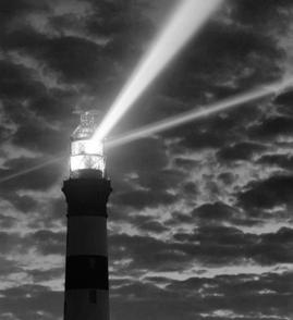
DEBRIS NET | LIGHT CONSTELLATION


On the next page of the Log, Nemo included photographs of a lighthouse on the shore of Chile. Based on his notes, the sketch on the right is said to be an illustration of a light constellation which would inhabit the unnavigable regions of the Pacific.


weighted sacks
Fuitional Two-Handed Cast any land and exists only as a calculated on the Pacific. region marked by
Fuitional Two-Handed Cast region marked by any land and exists only as a calculated on the Pacific.

VO70-395901-379
Due to the limited resource found in the central region of the ocean, the initial concept for the constellation light posts is pieced together using remnants of past satellites, retrieved from the seabed.

Communicating with Light [Photograph]
DEBRIS NET | CONSTELLATION


Communicating with Light [Photograph]
Communicating with Light

 Inspired by Christo and Jeanne’s floating installations, the constellation looks to provide an inhabitable surface on top of the water.
[Photograph]
Traditional Weighted Hand-cast Type of fishing method using weights [Diagram]
Inspired by Christo and Jeanne’s floating installations, the constellation looks to provide an inhabitable surface on top of the water.
[Photograph]
Traditional Weighted Hand-cast Type of fishing method using weights [Diagram]
DEBRIS NET | CONSTELLATION


Initial sketches explore the different formations that can be used for the constellation.


 StarLink Constellation & Quasicrystal [Photograph]
Traditional Weighted Hand-cast Type of fishing method using weights [Diagram]
StarLink Constellation & Quasicrystal [Photograph]
StarLink Constellation & Quasicrystal [Photograph]
Traditional Weighted Hand-cast Type of fishing method using weights [Diagram]
CONSTELLATION NET | GRAPHENE


The material of the constellation fabric is informed by modern graphene technology which allows the production of graphene sheets that are 300 times stronger than steel.


 Traditional Weighted Hand-cast Type of fishing method using weights [Diagram]
Traditional Weighted Hand-cast [Photograph]
Commercial Fishing Method - Purse & Trawl [Diagram]
Enclosed Purse Trawl Type of fishing method using weights [Diagram]
Traditional Weighted Hand-cast Type of fishing method using weights [Diagram]
Traditional Weighted Hand-cast [Photograph]
Commercial Fishing Method - Purse & Trawl [Diagram]
Enclosed Purse Trawl Type of fishing method using weights [Diagram]


CONSTELLATION NEMO | COMPONENTS


The zoom in of the plan highlights possible anchor placements, as well as wave barriers and the underwater cables that transport small debris.


 Underwater Oil Cable [Photograph]
Project MOSE Venetian Lagoon [Photograph]
Christo & Jeanne Islands Miami, Florida [Photograph]
Underwater Oil Cable [Photograph]
Project MOSE Venetian Lagoon [Photograph]
Christo & Jeanne Islands Miami, Florida [Photograph]
CONSTELLATION NEMO | COMPONENTS


 In relation to the plan, the sectional sketch echoes the different types of anchors which will stabilize the building.
Communicating with Light [Photograph]
Traditional Weighted Hand-cast Type of fishing method using weights [Diagram]
Offshore Oil Rig Anchor [Photograph]
In relation to the plan, the sectional sketch echoes the different types of anchors which will stabilize the building.
Communicating with Light [Photograph]
Traditional Weighted Hand-cast Type of fishing method using weights [Diagram]
Offshore Oil Rig Anchor [Photograph]


SPACE DEBRIS | CLASSIFICATIONS


Most reentries can be classified into 3 categories. Pre-determined satellite reentries are considered controlled. Detected reentries are semi-controlled. And lastly, uncontrolled reentry includes any undetectable objects, most likely fragments that are too small to be tracked.


 1. CONTROLLED RE-ENTRY 2. SEMI-CONTROLLED RE-ENTRY 3. UNCONTROLLED RE-ENTRY
Controlled re-entry is the ability to force the entry over a pre-determined area, region, within which the debris is to fall.
Semi-controlled implies less control of the debris’ trajectory. In most cases, the general landing area can be calculated but not altered.
Uncontrolled re-entry describes undetectable objects entering the Earth’s atmosphere, they may be small remains of meteors or satellites.
RemoveDEBRIS Satellite [NASA]
Allan Hills 84001 [UCLA Meteorite Collection]
Comet Wild 2 - Dust Particle [NASA]
Mir Space Station [Soviet Union]
Space Shuttle Columbia [NASA]
Comet Wild 2 - Dust Particle [NASA]
1. CONTROLLED RE-ENTRY 2. SEMI-CONTROLLED RE-ENTRY 3. UNCONTROLLED RE-ENTRY
Controlled re-entry is the ability to force the entry over a pre-determined area, region, within which the debris is to fall.
Semi-controlled implies less control of the debris’ trajectory. In most cases, the general landing area can be calculated but not altered.
Uncontrolled re-entry describes undetectable objects entering the Earth’s atmosphere, they may be small remains of meteors or satellites.
RemoveDEBRIS Satellite [NASA]
Allan Hills 84001 [UCLA Meteorite Collection]
Comet Wild 2 - Dust Particle [NASA]
Mir Space Station [Soviet Union]
Space Shuttle Columbia [NASA]
Comet Wild 2 - Dust Particle [NASA]
A. - POINT NEMO (South Pacific Ocean)
[4] - LANDING
Altitude: (<10 km)
Velocity: 11.7 km/s
Temp: 880 °C
[1] - SATELLITE DEORBIT
Altitude: (800 - 1,000 km)
Velocity: 4.2 km/s
Temp: 600 °C
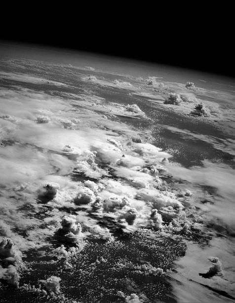
[ ATMOSPHERE RE-ENTRY ]
A. POINT NEMO
Point Nemo is so far from land, the nearest humans are often astronauts. The International Space Station orbits the Earth at a maximum of 416km. Meanwhile the nearest inhabited landmass to Point is over 2,700km away.
B. GRAVEYARD ORBIT
A graveyard orbit is used when the change in velocity required to perform a de-orbit maneuver is too large. Mainly consisted of dead geostationary satellites.
[1] - SATELLITE DEORBIT
Orbital maneuvering engines provide thrust to push the satellite towards Earth

TROPOSPHERE Altitude: (0 - 20 km)
MESOSPHERE Altitude: (50 - 85 km)
STRATOSPHERE
Altitude: (20 - 50 km)
[3] - BOOST GLIDE
Altitude: (15 -20 km)
Velocity: 7.8 km/s
Temp: 1,200 °C
THERMOSPHERE Altitude: (85 - 690 km)

[2] - VAPORIZATION POINT
Altitude: (60 - 70 km)
Velocity: 11 km/s
Temp: 1,480 °C
EXOSPHERE Altitude: (690 - 10,000 km)
[2] - VAPORIZATION POINT
Most satellites and space debris are vaporized in the mesosphere, the coldest layer in the atmosphere with temperatures reaching -90 degrees.
B. GRAVEYARD
ORBIT
Altitude: (39,000 - 40,000 km)
[3] - BOOST GLIDE
Method used to extend the total re-entry duration through the deploy of parachutes and gliders to temporarily lift the spacecraft.
[4] - LANDING
Landing of satellites and spacecrafts are often pre-determined and calculated to exact locations. The chance of harm to civillians must be lower than 1 in 10,000.
25 YEAR RULE ::
The priority of the Space Archive is to capture as many controlled reentries as possible, shown in red, since the speed, trajectory, and impact location can all be predetermined, unlike uncontrolled reentries shown in blue.
MISSION ISS | 2024


 The reentry of ISS has been set in the year 2024, the ISS will take over Mir as the largest object captured by the Nemo Space Archive.
THERMOSPHEREAltitude: (85690 km)
[1] - SOYUZ 1
Altitude: (170 - 200 km)
Velocity: 9 km/s
Landing Mass: 2800 kg
[ SATELLITE & SPACECRAFT ]

[1] - SOYUZ 1

TROPOSPHEREAltitude: (020 km)
STRATOSPHEREAltitude: (2050 km)

MESOSPHEREAltitude: (5085 km)

[2] - COLUMBIA
Altitude: (60 - 65 km)
Velocity: 18 km/s
Landing Mass: 80,700 kg
[3] - CHALLENGER
Altitude: (30 - 40 km)
Velocity: 16 km/s
Landing Mass: 62,500 kg
[5] - ASTEROID & COMET
Altitude: (10 - 20 km)
Velocity: 21 km/s
Landing Mass: Varying
[4] - SPACE DEBRIS

Altitude: (50 - 70 km)
Velocity: 11 km/s
Landing Mass: Varying
Crewed spaceflight of the Soviet space program. Launched into orbit on 23 April 1967 carrying 3 cosmonauts. The entire crew passed away from capsule depressurization in the thermosphere.
[2] - COLUMBIA
On February 1, 2003, Space Shuttle Columbia disintegrated as it reentered the atmosphere at about 65 km in altitude, in the mesosphere.
[3]
on January 28, 1986, when the Space Shuttle Challenger broke apart 73 seconds into its flight, killing all seven crew members aboard in the Earth’s stratosphere.
DEBRIS & ASTEROID ]

[4]
An average of 1 space junk enters Earth’s atmosphere per day and a total of 200-400 pieces of space debris enter our atmosphere per year.
[5] - ASTEROID & COMET
Asteroids enter at a speed typically in excess of 20 km/s, aerodynamic heating produces a streak of light, both from the glowing object and the trail of glowing particles that it leaves in its wake.

DAILY AVERAGE ::
Based on previous reentries such as the Columbia and Challenger shuttle, the mass and velocity of the shuttles upon landing is much different to that of their original.
 - CHALLENGER
- SPACE DEBRIS
- CHALLENGER
- SPACE DEBRIS
METEORITES | IMPACT


3 equations are used to calculate the mass and velocity of the ISS upon impact.


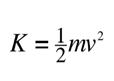


IMPACT | FORCE CALCULATION
 With a initial mass of 129tonnes, the ISS will land with a final mass of 98tonnes and a velocity of 8km/s -
IMPACT | FORCE ABSORPTION


In order to sustain this impact, the Archive needs to bulletproof itself. Informed by the traditional Kevlar vest, the building looks to use graphene to absorb the satellite’s entire kinetic energy without causing any form of ricochet.


PHYSICAL TESTING | MATERIALS
Three types of materials are tested to find the right combination of strength, buoyancy, and flexibility.

MATERIALS | BUOYANCY TEST

The materials are subjected to a buoyancy test.

IMPACT TEST | METAL MESH

As well as an impact test which measures the amount of force they can sustain while staying afloat.

SEQUENCE [1]

Scene: Start
SEQUENCE [3]
Scene: Capsize
IMPACT TEST | METAL MESH
As seen documented in the sequence above.
SEQUENCE [2]
Scene: Impact
Impact Mass: 3g
SEQUENCE [4]
Scene: End
PHYSICAL TESTING | CONCLUSION
In conclusion to the physical testing, the fabric that is to be fitted onto Nemo’s constellation will consist of a total of 5 layers. Including 2 layers of graphene, each reinforced with a layer of Kevlar, and a layer of polypropylene fabric, which supplies buoyancy to the bulletproof layers above it.

CONSTELLATION NEMO | DUST COLLECTION


 The assembly of these sheets will create the perfect capture site for space objects, as the only things that reach Point Nemo, are bacteria, satellites, and meteorites.
CONSTELLATION NEMO | DUST COLLECTION

 The first renders explore the floating pathways connecting the sheets as well as the possibility of lifting the sheet to create spaces under its membrane.
CONSTELLATION NEMO | DUST COLLECTION


 The section focuses more on the dust collection devices and the constellation lights.
IMPACT | SOFT LANDING

However, in order to capture large-sized satellites like Mir and ISS, more work is required to slow it down before impact.

A. - POINT NEMO (South Pacific Ocean)
[4] - LANDING
Altitude: (<10 km)
Velocity: 11.7 km/s
Temp: 880 °C
[1] - SATELLITE DEORBIT
Altitude: (800 - 1,000 km)
Velocity: 4.2 km/s
Temp: 600 °C
[ ATMOSPHERE RE-ENTRY ]
A. POINT NEMO
Point Nemo is so far from land, the nearest humans are often astronauts. The International Space Station orbits the Earth at a maximum of 416km. Meanwhile the nearest inhabited landmass to Point is over 2,700km away.
B. GRAVEYARD ORBIT
A graveyard orbit is used when the change in velocity required to perform a de-orbit maneuver is too large. Mainly consisted of dead geostationary satellites.
[1] - SATELLITE DEORBIT
Orbital maneuvering engines provide thrust to push the satellite towards Earth

TROPOSPHERE Altitude: (0 - 20 km)
MESOSPHERE Altitude: (50 - 85 km)
STRATOSPHERE
Altitude: (20 - 50 km)
[3] - BOOST GLIDE
Altitude: (15 -20 km)
Velocity: 7.8 km/s
Temp: 1,200 °C
EXOSPHERE Altitude: (690 - 10,000 km)
THERMOSPHERE

Altitude: (85 - 690 km)
[2] - VAPORIZATION POINT
Altitude: (60 - 70 km)
Velocity: 11 km/s
Temp: 1,480 °C
B. GRAVEYARD ORBIT
Altitude: (39,000 - 40,000 km)
[2] - VAPORIZATION POINT
Most satellites and space debris are vaporized in the mesosphere, the coldest layer in the atmosphere with temperatures reaching -90 degrees.
[3] - BOOST GLIDE
Method used to extend the total re-entry duration through the deploy of parachutes and gliders to temporarily lift the spacecraft.
[4] - LANDING
Landing of satellites and spacecrafts are often pre-determined and calculated to exact locations. The chance of harm to civillians must be lower than 1 in 10,000.
SOFT LANDING
Used by reentry capsules, there are 4 steps to a soft landing. These steps allow the satellite to travel a longer distance in order to slow down its velocity.