GANGES RIVER
IN THE AGE OF THE ANTHROPOCENE
TRACING FLOODPLAIN POLITICS OF ENGINEERED LANDSCAPES
AND A SHIFT TOWARDS
DEMOCRATIC FLOODSCAPES
IN THE ERA OF CLIMATE CHANGE
KRITI GARG
GANGES RIVER IN THE AGE OF THE ANTHROPOCENE
Kriti Garg, 414862
Master thesis submitted in partial fulfillment of the requirements for the degree
M.Sc. Urban Design, Technische Universität Berlin
Supervisors:
Prof. Dipl.-Ing. Anke Hagemann
Anna Wilk-Pham
Berlin, September 2022
Fig. 1(Cover): Floodplain elevation map
GANGES RIVER
IN THE AGE OF THE ANTHROPOCENE
TRACING FLOODPLAIN POLITICS
OF ENGINEERED LANDSCAPES
AND A SHIFT TOWARDS
DEMOCRATIC FLOODSCAPES
IN THE ERA OF CLIMATE CHANGE
Declaration of Ownership
I declare that this is my own work and that I have used no other sources than the ones indicated. I have accurately and consistently referenced all the published and unpublished material that I have referred to, whether by direct quotation or reference to an idea.
This work has not been presented in the same or similar version for another examination.
Berlin, 14 September 2022
Kriti Garg
PREFACE
Growing up in New Delhi (capital city of India) I had two distinct experiences with a river. The first was defined by my childhood memories that filled me with awe and joy remembering my week long school trips via overnight trains to the Himalayan hill stations for rafting expeditions along one of the most pristine stretches of the Indian rivers. We experienced up close the force of nature, the beauty of rapids and the named mysteries of a riverbed terrain that were called by names as bizarre as ‘the three blind mice’ or ‘the wall’. We appreciated nature and soaked it all in, camped under the night stars on the sand banks of the river and shivered soaking wet on our boats for hours as we crossed a curve in the river behind a giant mountain. It is a memory I will always cherish and take with me through life. Yet, the second experience was on an opposite extreme, defined by the Jamuna River flowing by New Delhi. The only interaction I had with it was seeing it in passing during a quick drive over the bridge, quickly rolling up the windows as a distinct pungent smell came from it. The river in the city, I told myself, had nothing to do with the one I knew from the mountains. This made me always wonder, how come we can live in such a paradox, where two opposing realities along the same river can exist so strongly?
In this thesis I want to embark on a journey in order to find a reawakening of sorts, one towards rivers, which explores a sensitivity we have lost to pragmatics of daily life in the urban metropolis and where a messy list of demands has made us shortsighted of what passes by us.
Berlin, September 2022
Kriti Garg
CONTENTS
ABSTRACT/ ZUSAMMENFASSUNG
FLOODPLAIN TERMINOLOGY
INTRODUCTION
Between water and land: floodplains in a state of crisis
16 Introduction to Floodplains
20 Objectives/ Thesis Questions
26 Methodology
THREE POLITICS OF RIVERS
32
Politics of Infrastructure
A strategic disconnect in three stages
34 Stage 1 (1600 -1947): Ganges Canal
48 Stage 2 (1947 - current): India’s Green Revolution
54 Stage 3 (1990 - current): Barrage Construction in Kanpur
64
Politics of Land
Floodplain governance structures & settlement typologies
66 Current State of Floodplain Planning in India
58 Site Observations at Brijghat (rural)
86 Corrupt Khaddar Farming System in New Delhi (urban)
92 Four Floodplain Communities of Kanpur City (in transformation)
92 River Floodplain Settlement Typologies
8 10 29 16 _ _ _ _
155 128 131 160 _ _ _ _ FUTURE OUTLOOK Lessons learned from being within floodplains and around wetness... THESIS STATEMENT A strategic disconnect from floodplains STRATEGY PROPOSAL 132 Floodscapes, a new Democratic Space of Refuge and Care Rethinking the role of floodplains in the 21st century 134 Five Strategies towards Democratic Floodscape Planning 140 Rethinking Floodplains of Kanpur Metropolitan Area APPENDIX 108 Politics of Water From the fertile valley to the fatal valley 110 Local Impacts of Floodplain Settlements 112 Water Accounting for Kanpur Metropolitan Area 121 Ecological Implications of Floodplain Degradation 122 Climate Change Implications
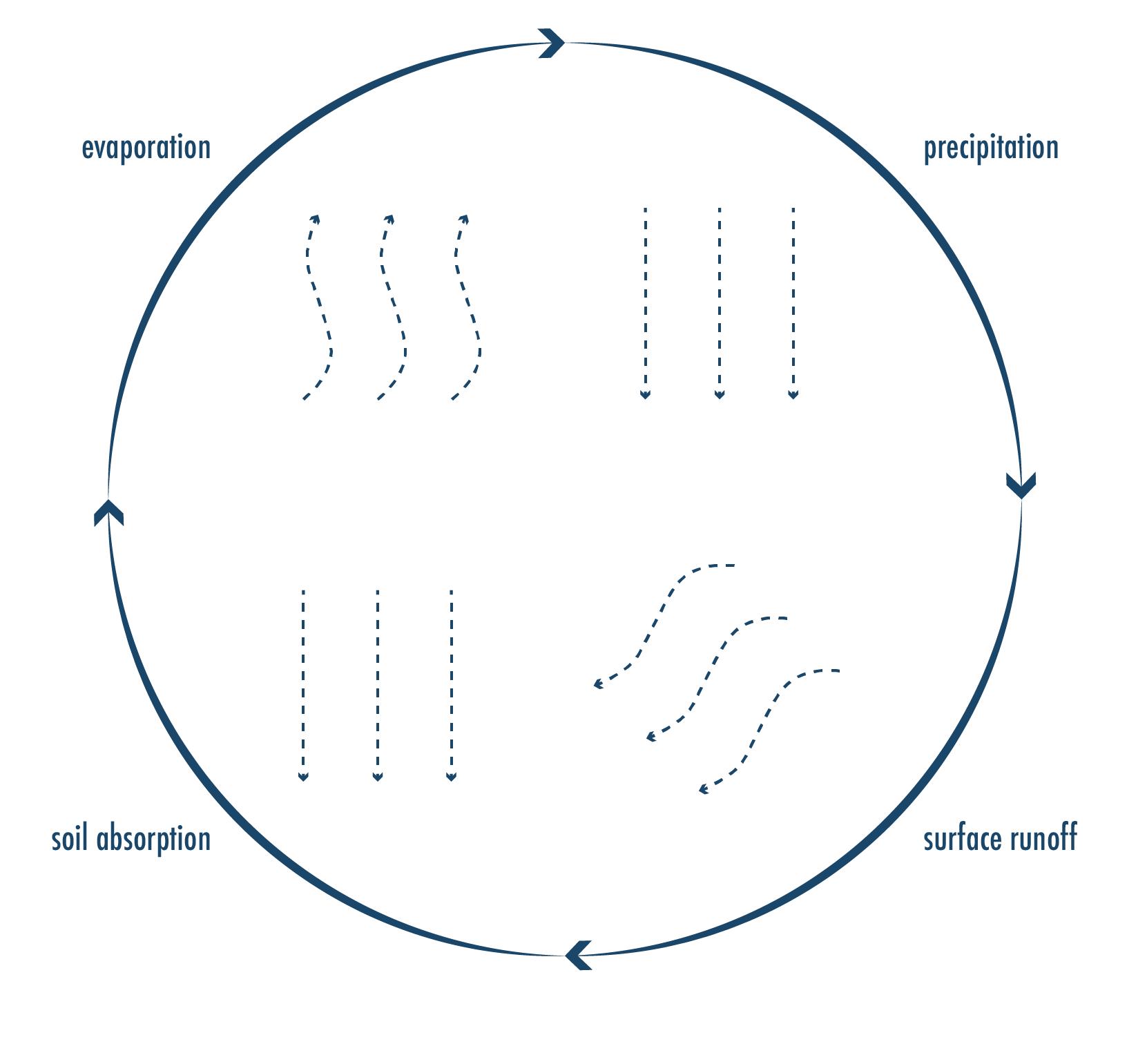
Looking within the context of the Ganges River Basin in India, the thesis explores through three distinct topics of river infrastructure, land-use and natural water cycles- the transformation of floodplains along the Ganges River and it’s impacts which make India one of the heaviest affected inland river flooding regions worldwide. Divided into three main research sections, the first section establishes a historical context within which political drivers have triggered large scale floodplain transformations through new logics of engineered landscapes (politics of infrastructure). The second section goes on to understand the various governance models that exist around floodplain land-use and ownership in India today (politics of land) by studying three sites, a rural river setting (Brijghat), an urban river setting (New Delhi) and a third river setting currently in transformation from rural to urban (Kanpur Metropolitan Area - KMA). Taking the transformation under a closer lens, the impacts of floodplain transformations are studied by analyzing the effects of rapid urbanization on the natural water cycles of the river (precipitation - surface run-off - soil absorption - evaporation rate) (politics of water) (see Fig. 2). Finally, this thesis explores how new logics of engineered landscapes of floodplains also require new logics of floodplain planning by proposing a set of strategies to achieve new Democratic Floodscapes, a site of productive landscapes that host both sustainable economies as well as healthy ecologies, providing refuge and care for all inhabitants within floodplains.
Im Kontext des Ganges-Einzugsgebiets in Indien untersucht die Dissertation anhand von drei verschiedenen Themen - Flussinfrastruktur, Landnutzung und natürliche Wasserkreisläufedie Umwandlung von Überschwemmungsgebieten entlang des Ganges und ihre Auswirkungen, die Indien zu einer der am stärksten von Binnenhochwasser betroffenen Regionen weltweit machen. Der erste Abschnitt gliedert sich in drei Hauptforschungsabschnitte und stellt den historischen Kontext dar, in dem politische Faktoren die großflächige Umgestaltung von Überschwemmungsgebieten durch neue Logiken der technisierten Landschaften (Politik der Infrastruktur) ausgelöst haben. Der zweite Abschnitt befasst sich mit den verschiedenen Governance-Modellen, die heute in Indien im Zusammenhang mit der Landnutzung und den Eigentumsverhältnissen in Überschwemmungsgebieten existieren (Landpolitik), indem drei Standorte untersucht werden: ein ländliches Flussgebiet (Brijghat), ein städtisches Flussgebiet (Neu-Delhi) und ein drittes Flussgebiet, das sich derzeit im Wandel vom ländlichen zum städtischen Gebiet befindet (Kanpur Metropolitan Area - KMA). Die Auswirkungen der Veränderungen in den Flusslandschaften werden untersucht, indem die Auswirkungen der raschen Verstädterung auf die natürlichen Wasserkreisläufe des Flusses (RegenOberflächenabfluss - Wasseraufnahmefähigkeit des Bodens - Verdunstungsrate) analysiert werden (Politik des Wassers) (siehe Abb. 2). Schließlich wird in dieser Arbeit untersucht,
8 Ganges River in the Age of the Anthropocene
ABSTRACT / ZUSAMMENFASSUNG
wie neue Logiken der technischen Landschaften von Überschwemmungsgebieten auch neue Logiken der Flussgebietsplanung erfordern, indem eine Reihe von Strategien vorgeschlagen wird, um neue demokratische Überschwemmungslandschaften zu schaffen, die sowohl nachhaltige Ökonomien als auch gesunde Ökologien beherbergen und allen Bewohnern von Überschwemmungsgebieten Zuflucht und Pflege bieten.
9
Fig. 2: Natural water cycle.
Abstract/ Zusammenfassung
river
A wide, natural stream of fresh water that flows from a high elevation point inland, downstream into an ocean.
anthropocene
An unofficial epoch or geologic unit of time termed by geologist describing the most recent period in earth’s history when human activity started to have a significant impact on the planet’s climate and ecosystem.

10
Fig. 3: Floodplain terminology sketches.
in
Ganges River
the Age of the Anthropocene
floodplain
A generally flat area of land next to a river or stream stretching from the banks of the river to the outer edges of the valley. It consists of two parts, the floodway making up the main channel, and the flood fringe which extends from the floodway all the way out to the edge of the valley wall, also known as the bluff line.
engineered landscape
A landscape that has been altered, designed or engineered through scientific procedures to meet declared goals of human demands.

11
Floodplain Terminology
FLOODPLAIN TERMINOLOGY
(All floodplain terminology definitions are derived from explanations found Online on the website of National Geographic, Oxford Languages and Wikipedia, as well as from the referenced work for this thesis research.)
Anthropocene
an unofficial epoch or geologic unit of time termed by geologist describing the most recent period in earth’s history when human activity started to have a significant impact on the planet’s climate and ecosystem
Barrage an artificial barrier across a river or estuary to prevent flooding, aid irrigation or navigation, or to generate electricity by tidal power
Canal an artificial waterway constructed to allow passage of boats or ships inland or to convey water for irrigation
Critical zone the thin layer of the Earth, in which all living beings and processes of life are inextricably entangled with each other
Dam a barrier constructed to hold back water and raise its level, forming a reservoir used to generate electricity or as a water supply
Discharge quantity volume of water flowing in the river measured in cubic meters per second (m3/s or cumec)
Diwani [Hindi term used for] the right to collect taxes
Doaab [Hindi term for] river basin
Embankment a wall or bank of earth or stone built to prevent a river flooding an area or to carry a road or railway over an area of low ground
Encroachments intrusion or a gradual advance beyond usual or acceptable limits
Engineered landscapes landscapes that have been altered, designed or engineered through scientific procedures to meet declared goals of human demands
Flood fringe area extending from the floodway all the way out to the edge of the river valley wall, also known as the bluff line
Flooding the converging or submerging of normally dry land with a large amount of water
Floodplains /flood plains a generally flat area of land next to a river or stream, stretching from the banks of the river to the outer edges of the valley
Floodscapes as termed by Rossano (2021), landscapes engineered and designed to naturally flood
Floodway main water channel of a river valley filled most year round with water
Ghat path or stairs leading down to a river or water body
Harvest the process or period of gathering crops
Inundation the process of a dry area being permanently drowned or submerged
12 Ganges River in the Age of the Anthropocene
Khaddar farming system floodplain farming system as accompanied by land division customs within India
Khadir [Hindi term used for] floodplains
Kharif crops crops grown with the onset of monsoon in different parts of the country and harvested in September-October. ex rice, maize, millet, ragi, pulses, soybean, groundnut
Land use practice involving the management and modification of natural environment or wilderness into built environment such as settlements and semi-natural habitats such as arable fields, pastures, and managed woods
Levee an embankment built to prevent the overflow of river
Monsoon seasonal rains passing through the sub-continent of India between the months of May through September
Peak discharge quantity highest recorded volume of water flowing in the river measured in cubic meters per second (m3/s or cumec)
Perennial lasting or existing for a long time; enduring or continually recurring
Politics a form of influence over spatial design by powerful actors
Portable water clean water for domestic household use
Takvi an institution predating (The East India) Company rule that provided government loans to assist cultivators to finance improvements (ex. Irrigation schemes)
Rabi crops are sown in winter from October to December and harvested in summer from April to June. ex. wheat, barley, peas, gram and mustard
River a wide, natural stream of fresh water that flows from a high elevation point inland, downstream into an ocean
River basin an area of land from which all flowing surface water converges to a single river directly or through tributary water bodies such as lakes or rivers
River infrastructure basic physical and organization structures and facilities needed for the ‘as per demanded’ operation of water within a river
Sow plant (seed) by scattering it on or in the earth
Water (essence of life)
13
Floodplain Terminology
14 Ganges River in the Age of the Anthropocene
TOPIC AND CONTEXT
15
“the river—as ecology and human habitat—has been reshaped over time, [one must understand] its present as a product of a history of human-environmental interaction, but also violent intervention”
BETWEEN WATER AND LAND: FLOODPLAINS IN A STATE OF CRISIS
Floodplains have always been part of river systems around which humans built and sustained life. Floodplains provide a source of fresh water, they nurture civilizations through fertile alluvial soils rich in minerals but also they are sites of sacred rituals in many cultures such as the worshiped sites of the Nile in Egypt (Etheredge) and the Ganges River in India. But as climate change has brought to the foreground, floodplains have become sites of extreme flood events, as river swell up to new magnitudes through many factors ranging from extreme weather events to ecological degradation of unique ecosystems like wetlands (known to be worlds largest natural carbon sinks), to deforestation of big riparian forests full of biodiversity and soil erosion caused by industrialized methods of farming, all factors disrupting a balanced cycle of both water as well as carbon emittance and storage in soil (Dhar and Nandargi, 2003:10).
Rivers, in their natural state are transient, swelling in wet seasons and shrinking in dry season. Mighty rivers of our world like the Amazon in South America or the Mekong in Asia, can transform complete landscapes in their seasonal fluctuations as they swell in multitudes (see Fig. 6 on page 21). The Ganges River in India, if childhood anecdotes of relatives can be believed, was so timid during dry season that a crossing from one bank side to the other could occur by foot through the riverbed. Yet, the same spot in wet season wouldn’t allow the sighting of the opposite bank side.
Yet, throughout history, humans have systematically tried to dominate over natural river systems in the hope to tame and profit from linear, channelized rivers. In the book Floodscapes, Rossano (2021: 65) explains the general attitude towards floodplains in Europe in the 16th century:
‘Various ontological attitudes towards the river coexisted after the Enlightenment: that of acceptance towards living element to be enjoyed in its primary and unspoiled state, and, at the other end of the spectrum, that of contempt for a chaotic and pointless phenomenon that only became meaningful through its transformation and exploitation, with the latter eventually winning over the former.’
Rossano here reveals an important turning point in history, an era of engineers who decided
16
Ganges River in the Age of the Anthropocene INTRODUCTION
(Mississippi. An Anthropocene River, 2018)
over the fate of rivers and shaped new realities of river sightings. Furthermore, Rossano describes the importance of narratives through which engineers justified many projects in Europe from the 16th century onwards that lead to large transformations of floodplains across most European countries today. Portrayed as an act of salvation of nature by humans, Rossano (2021: 67) gives one such example of the narrative used during the canalization process of the Rhine river in Germany under the supervision of Johann Gottfried Tulla, the Rhine’s head engineer whose:
‘vocabulary used for the canalization of the river was far from innocent: the Rektifikation des Rheins (Tulla, 1825) related both to its geometry - the snake’ losing 75 kilometers of its original curves- and to its morals; the twisted, unproductive, and dangerous river was turned into a channel made ‘right’, suitable for navigation from Mannheim up to Basellosing en passant about 80 percent of its riverine ecosystem (Blackbourn, 2007: 71-111)’
No different was the state of affairs among engineers and colonialists of the British Empire that came to India in the 16th century to expand their trade routes and maximize natures output to their own gains as described through the extensive research work by Acciavatti (2015: 114-115) in his book Ganges Water Machine. Acciavatti follows the history and motivations behind the construction work of the Ganga Canal in India’s fertile Gangetic plains during the East India Rule in India from the 1750s onwards, where the head engineer Sir Proby Cautley of the Ganga Canal describes ‘the Ganga and the Jumna (Jamuna) rivers as “so capricious in their actions, so violent in their floods...”’ (Acciavatti 2015: 103).
Planners, engineers, and politicians aim to avoid catastrophic events in which both ends of the extreme weather spectrum lead to large economic and personal losses of both local inhabitants as well as the ruling regimes. In India, such extremes range from cloudbursts causing river swellings beyond infrastructural control to wind shifts depriving vast regions of agricultural land of seasonal rains, leading to starvation and famine across large regions. But this obsession with ruling over natural forces has created a paradox, and so instead of building a deeper understanding towards river systems we have landed in an era of engineered landscapes with largely consists of disconnected natural river system (Dixit, 2003). Fragmented water networks disrupted by elements of river infrastructure have created new logics of water flows orchestrated by dams, embankments and canals, each playing a part in directing and calibrating the flow of water for our needs towards ‘agricultural prosperity’, a system which Malterre-Barthes (2016) claims has been a long lasting tradition motivated by
17
Introduction
‘colonial technocracy’.
These extensive infrastructural system might provide momentary relief from disasters, but in the long term, have chained us to a cycle of repair and maintenance. Yet, as true for any forms of infrastructure, river infrastructure too, get outdated with time and eventually buckle under pressure- causing catastrophic events of its own.
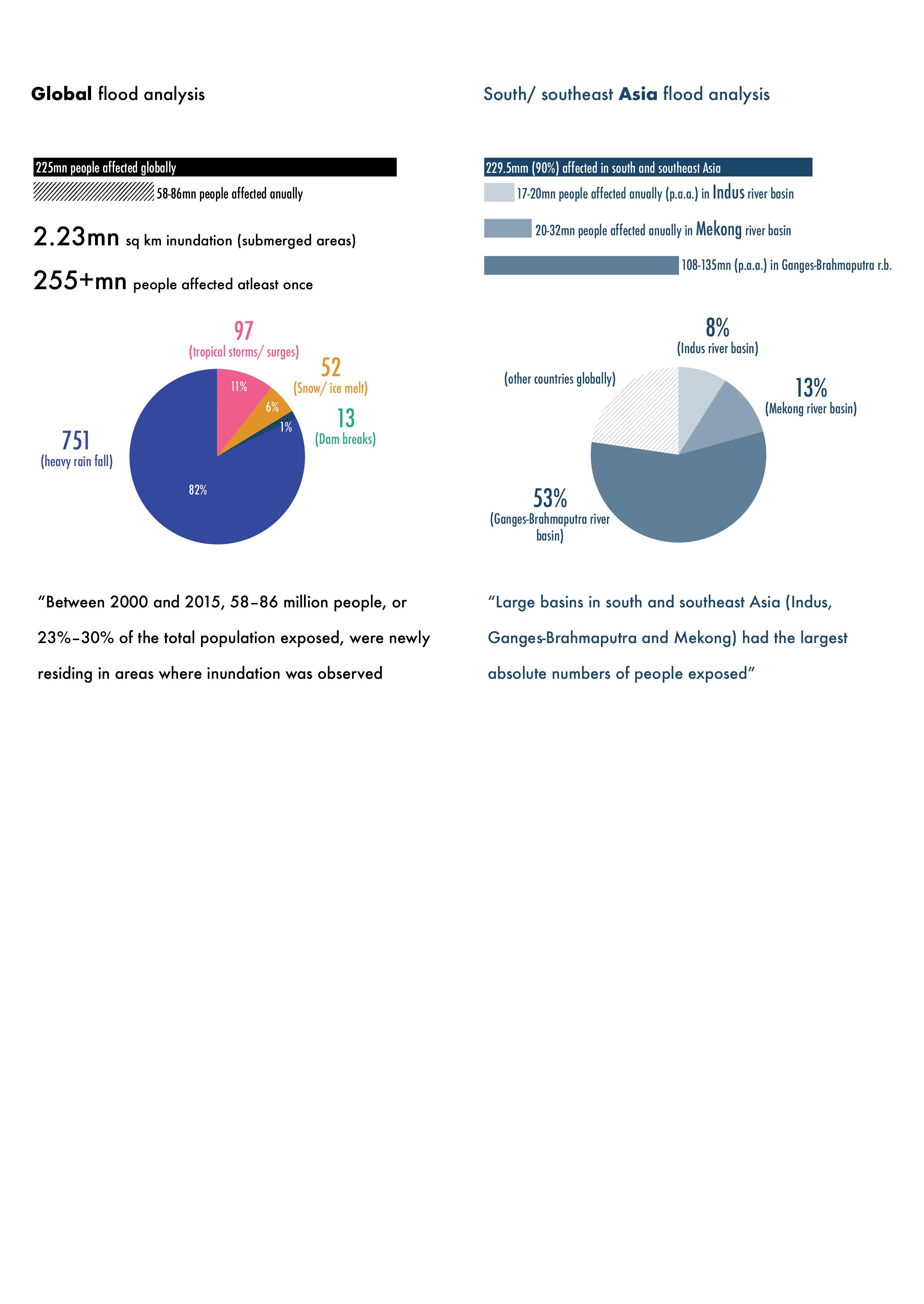
FLOODS ON A GLOBAL SCALE
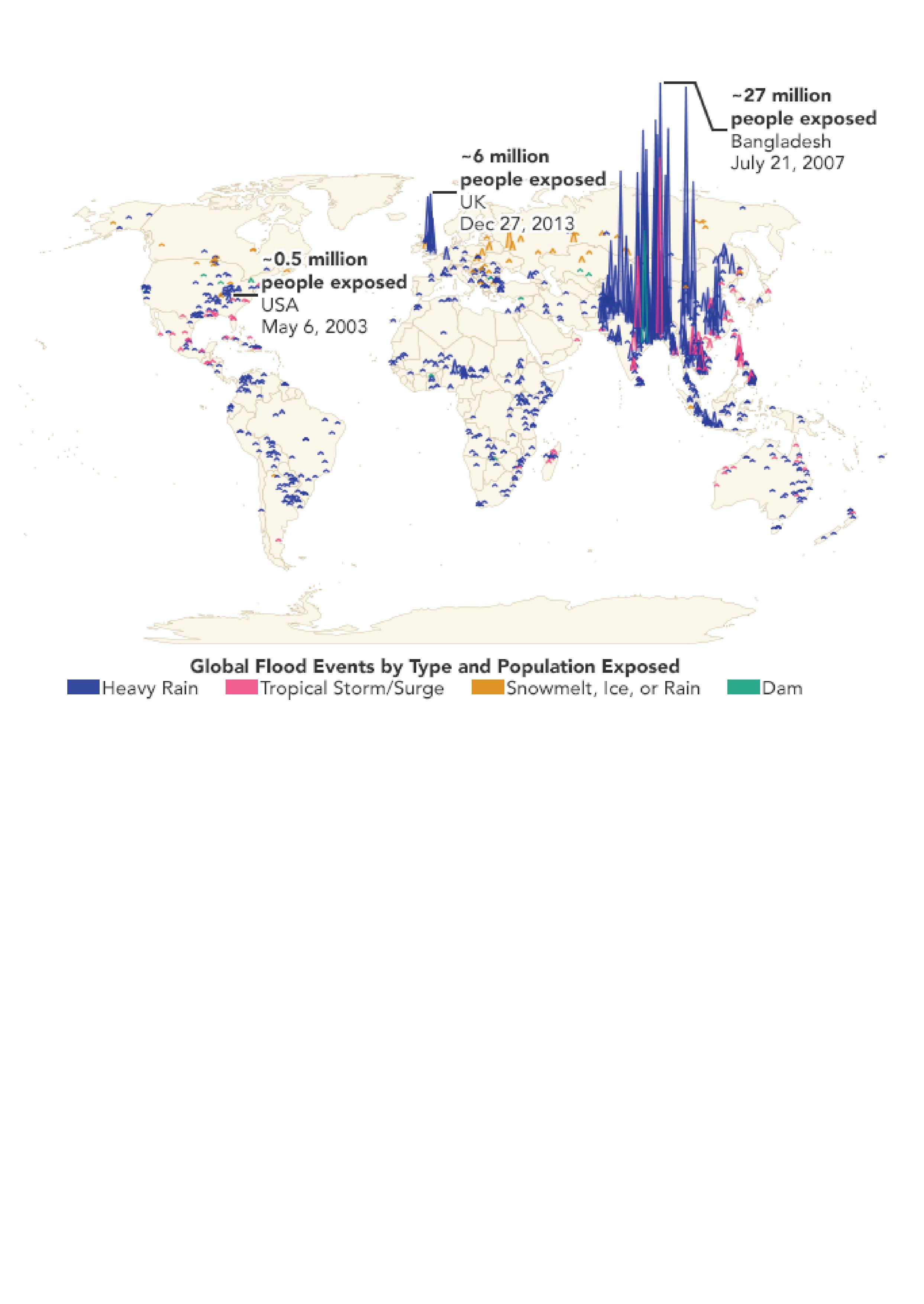
A study published by NASA Earth Observatory (2021) had studied the phenomenon of flood on a global scale. Studying over 900 major flood events between the year 2000 to 2015, they evaluated flood events by cause and the number of people affected. Concluding that close to 255 million people worldwide are affected by a major flood event at least once in their lifetime. But also that 58-86 million people settle permanently into floodplain regions. Their study showed that there was an increase of 20 - 24% percent in world population exposed to floods, a number almost 10 times greater than what previous models had predicted. Scientists noted:
‘high population growth and urban migration force many to inhabit floodplains usually
18 Ganges River in the Age of the Anthropocene
Fig. 4: Global flood events by type and total population exposed, NASA Earth Observatory (2020)
reserved for agriculture as cities fall behind to plan in time or ahead of these occurrences’
and that beyond global warming which already contribute to more severe weather patterns and flood events, a general trend of global migration into floodplains, especially of vulnerable and marginalized populations who lack better options and opportunities elsewhere, were becoming the causalities of floods. As shown in their map (Fig. 4) they concluded that both extreme weather events but also failed hydraulic projects were among the main factors of increased flood risks.
So when assessing the map of NASA’s general findings, flood events occur globally, but through a combination of extreme weather events, failed engineered hydraulic projects and a marginalized communities inhabiting flood plains, India and Bangladesh are currently among the highest affected regions by floods globally (Fig. 5). Alone in India a study by World Bank showed that within two consecutive years, flood events within the Ganges River Basin affected 47 million people (Priya et al. 2017: 35).
The study pointed out that 90% of the major flood events studied were occurring in South and Southeast Asia, with the most heavily affected river basins being the river Indus and Ganges-
19 Introduction
Fig. 5: Flood event data of Global vs. Asia, NASA Earth Observatory (2020)
Brahmaputra rivers in India, Pakistan and Bangladesh and of the river Mekong flowing through Vietnam, Thailand, Laos, Cambodia, China and Myanmar (Tellman et al., 2021: 81).
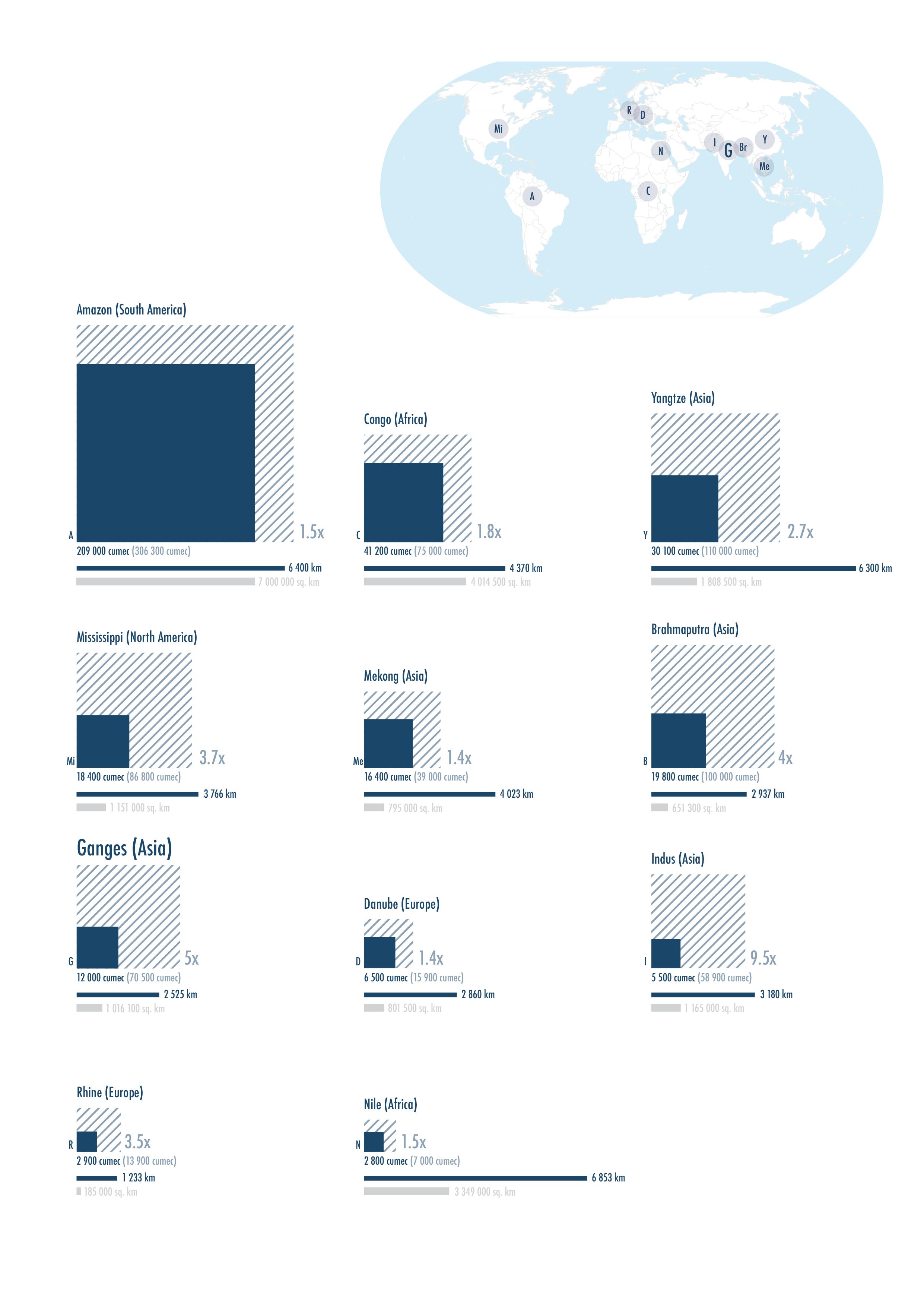
A quick study in Fig. 6 gives a visual representation of major rivers around the world as they swell up in moments of flood events. The average discharge quantity of the river (in cubic meters per second, abbreviated as cumec) is represented by a solid blue square while the highest recorded maximum discharge quantity of the river is shown in a hatched blue square placed in relation to it. By this logic, the Mekong can swell up to 1.4 times it’s average size while the Ganges river swells up 5 times it size and the Indus river up to 9.5 times. It is precisely these moments that can happen either annually during the expected wet seasons, making headlines and staying in peoples conscious or these events can happen sporadically, catching people by surprise and off-guard.
It is exactly this phenomena that is theorized in the works of Anuradha Mathur and Dilip da Cunha (2020: 192) in their work Wetness is Everywhere; Why do we see Water Somewhere? were they question the current state of flood events in India as a misunderstood relationship between land and water:
‘It is a surface, however, that is uncomfortable with water to the extent of being on several occasions destroyed or threatened by it, whether through floods, scarcity, mold, or today, sea-level rise. These are treated as problems to solve or conditions to accommodate. But is this what they are? Or are they signs of a surface that exists by design, a surface posited by people driven to control wetness?’
Highlighting one of the many challenges cartographers, planners and designers alike often face while studying and planning around river is the aim of controlling what Mathur and Da Cunha (2020) term wetness. Typical maps whether found in an Atlas or Google Maps stamp a river into a snapshot in time. The river is drawn or depicted as two parallel lines on a map with oftentimes an obsession with wanting to identify a clear beginning and end by which the rivers path is defined. Thus, pronouncing every deviation from it, a type of catastrophe that needs taming and mending. Instead, they challenge us to rethink mapping of rivers, redrawing it to capture the natural meandering of rivers over time, showing relationships of rivers to rain, to people, to ecology and most importantly, questioning how combining all these relationships to one cyclical network of elements and actors could also change the perception of planning floodplains with a new awareness and equity to water and ecology. Something that could
20 Ganges River in the Age of the Anthropocene
21 Introduction
Fig. 6: Major river’s around the world by average discharge volume (solid blue square) vs. maximum discharge volume (hatched blue square).
benefits all inhabitants of floodplains alike.
It is this notion of understanding temporal processes and human attitudes towards nature, that needs further exploration. Through mapping exercises and exploratory methods of documenting landscape transformation for example through gathering water narratives, an already embedded knowledge of water within communities could reveal existing synergies between water and humans within contested sites of floodplains.
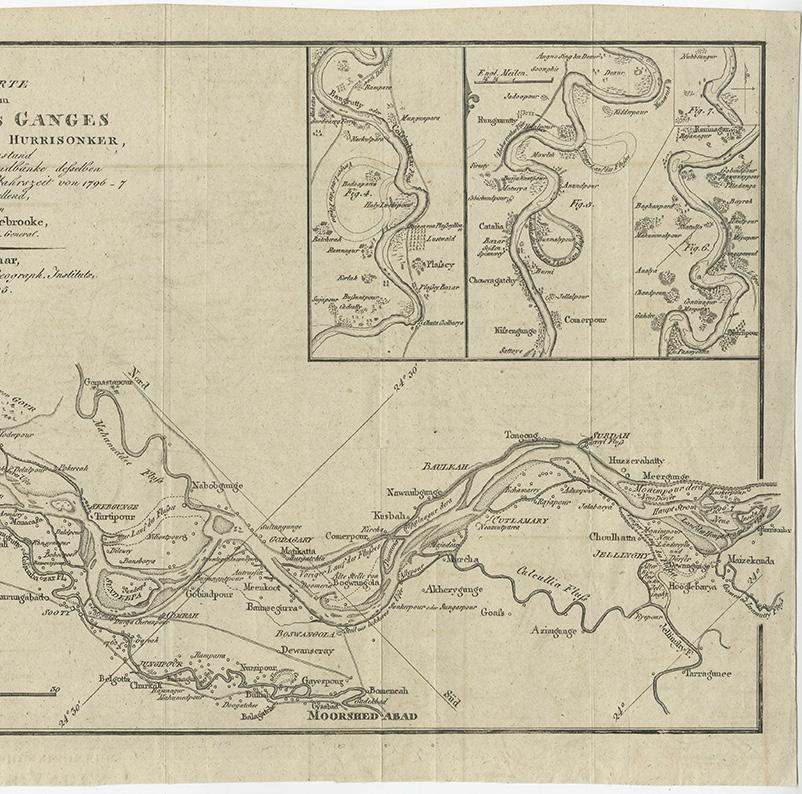
This practice is not new, but rather forgotten in contemporary depictions and mainstream cartography. One such example is the old survey map published in 1805 by R.H. Colebrooke, (Fig. 7) an engineer from Weimar’s Geography Institute. It depicts annotations of temporal activities within floodplains. Titled in original language German as, ‘Laufe des Ganges von
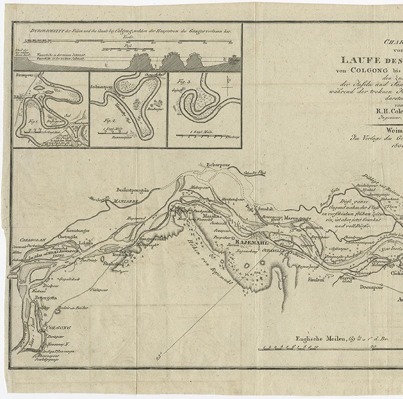
22 Ganges River in the Age of the Anthropocene
Fig. 7: Map by Colebrooke depicting activities and the process of natural river meandering from Colgong to Hurrisonker, 1805.
“Diese ganze Gegend nahm der Fluss zu verschiedenen fruehern Zeiten ein, ist aber jetzt bewohnt und voller Doerfer”
“This whole area was taken up by the river to different earlier times, but now it is settled and full of villages”
Colgong bis Hurrisonker, den Zustand der Inseln und Sandbänke derselben während der trocken Zeit von 1796-7’ which translates in English to ‘The flow of the Ganges from Colgong till Hurrisonker, the condition of the islands and sandbanks of the same during the dry season of 1796-7’ (Colebrooke, 1805).
Surveys like these were most likely done on a repeated visit basis as it includes annotations of activities of villagers and their settlement activities while also noting down the natural transformations in sandbank and island formations within the river. This map not only draws the physical features of the river and surrounding landscapes, but also describes and annotates narratives of temporal activities along the river, a practice we must embed back into contemporary consumption of maps which focus too much on satellite technology that captures only moments in time and too little processes and activities over time.
23
Introduction
OBJECTIVE / THESIS QUESTIONS
In my thesis, I want to explore these phenomena of floodplain transformation triggered by human activities and understand the events and politics that guide their actions. How has politics, as a form of influence over spatial design by powerful actors, led to certain transformations of floodplains in the Ganges River Basin over time? What is the impact of inhabitants living in floodplains on the river and on each other? How are engineered landscapes straining the natural water cycle locally and trans-locally? And lastly, what challenges do we face today in better planning floodplains and creating security for the millions of people that inhabit these floodplains?
What I hope to find through my research, is a reawakening of sorts, one that reflects on the past actions we have taken towards rivers and the transformations we have initiated in its floodplains. To than ask ourself, planners, politicians, and engineers alike, how can we break a cycle of man-made dependencies to hard infrastructure and catastrophes based on past infrastructural projects that were calibrated to a single instance in time and are already outdated for the current climate challenges. And instead, rethink floodplains through the lens of Bruno Latour’s 3rd attractor, by landing on the terrestrial (Latour, 2019) and studying a thin surface in it’s given geo-political surrounding. By focusing on exactly these geo-politicial conditions, the thesis work aims to understand the politics and challenges of floodplain planning within the context of India, and more specifically, that of the Ganges River and its adjacent floodplains.
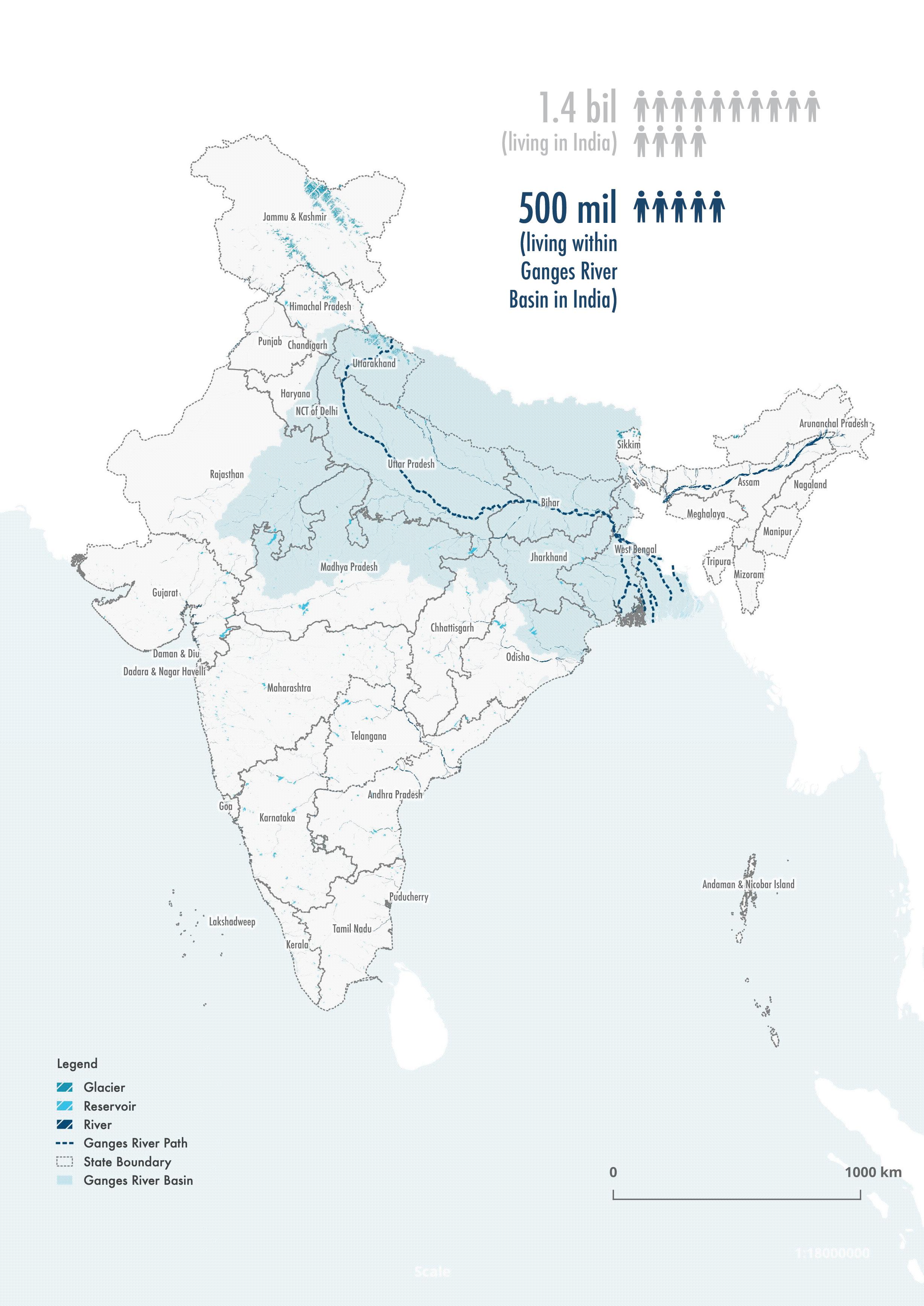
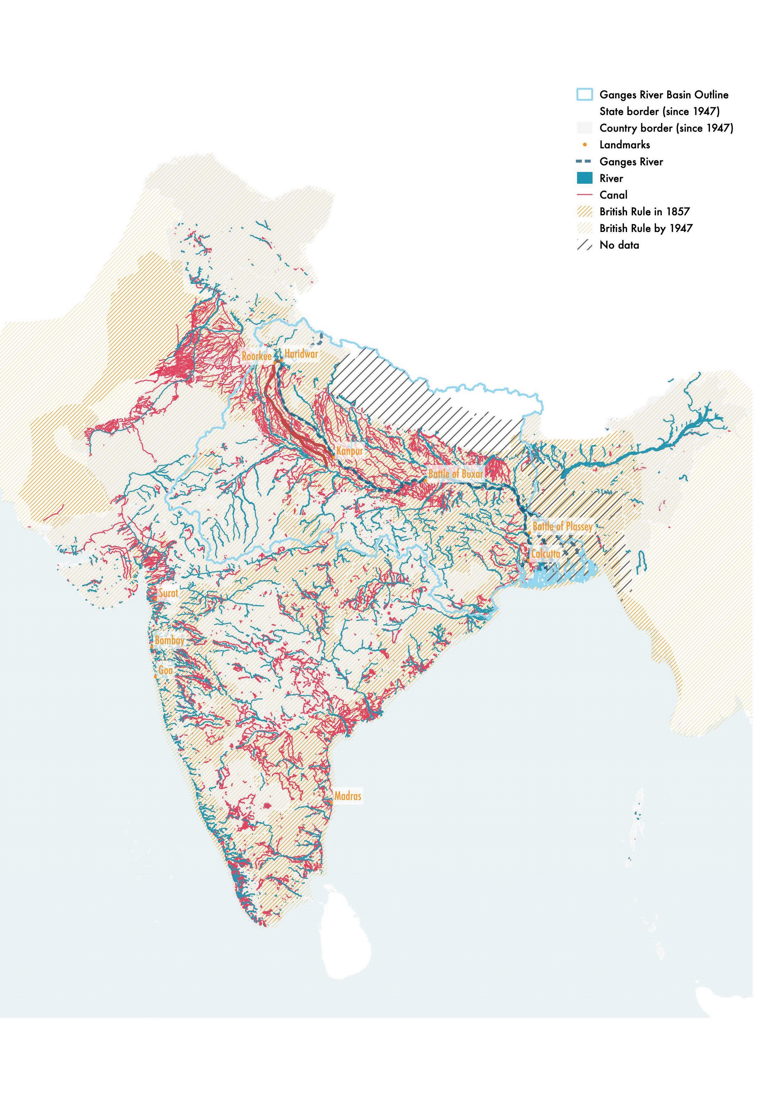
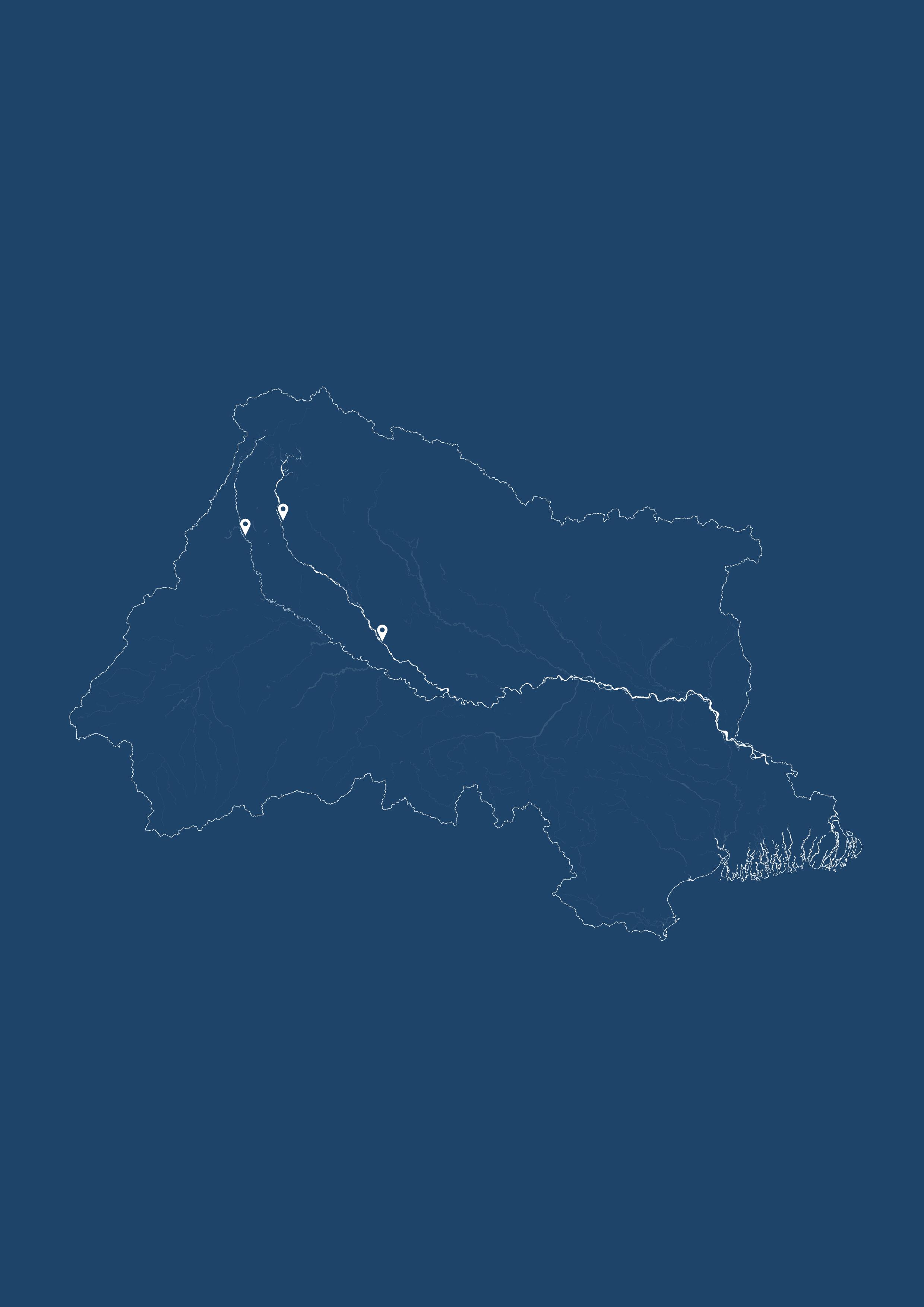
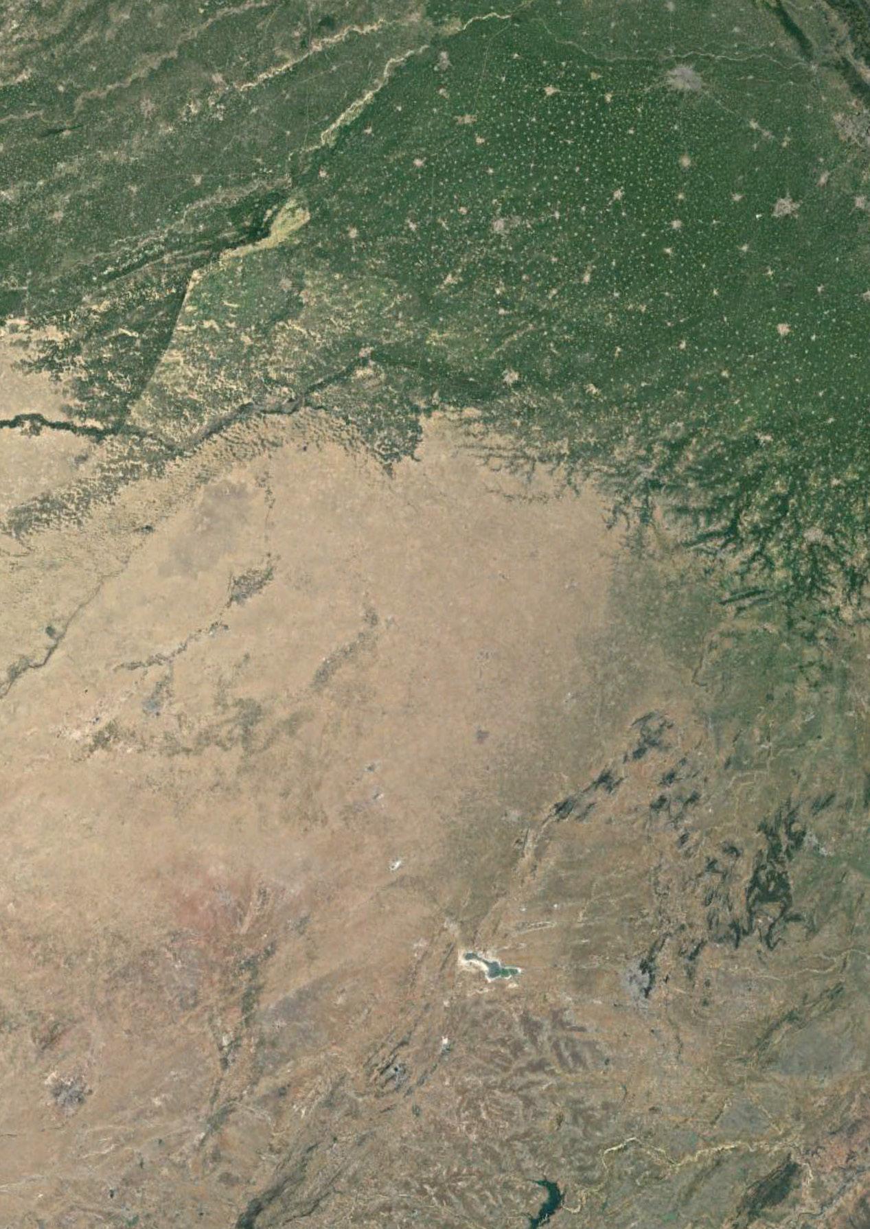
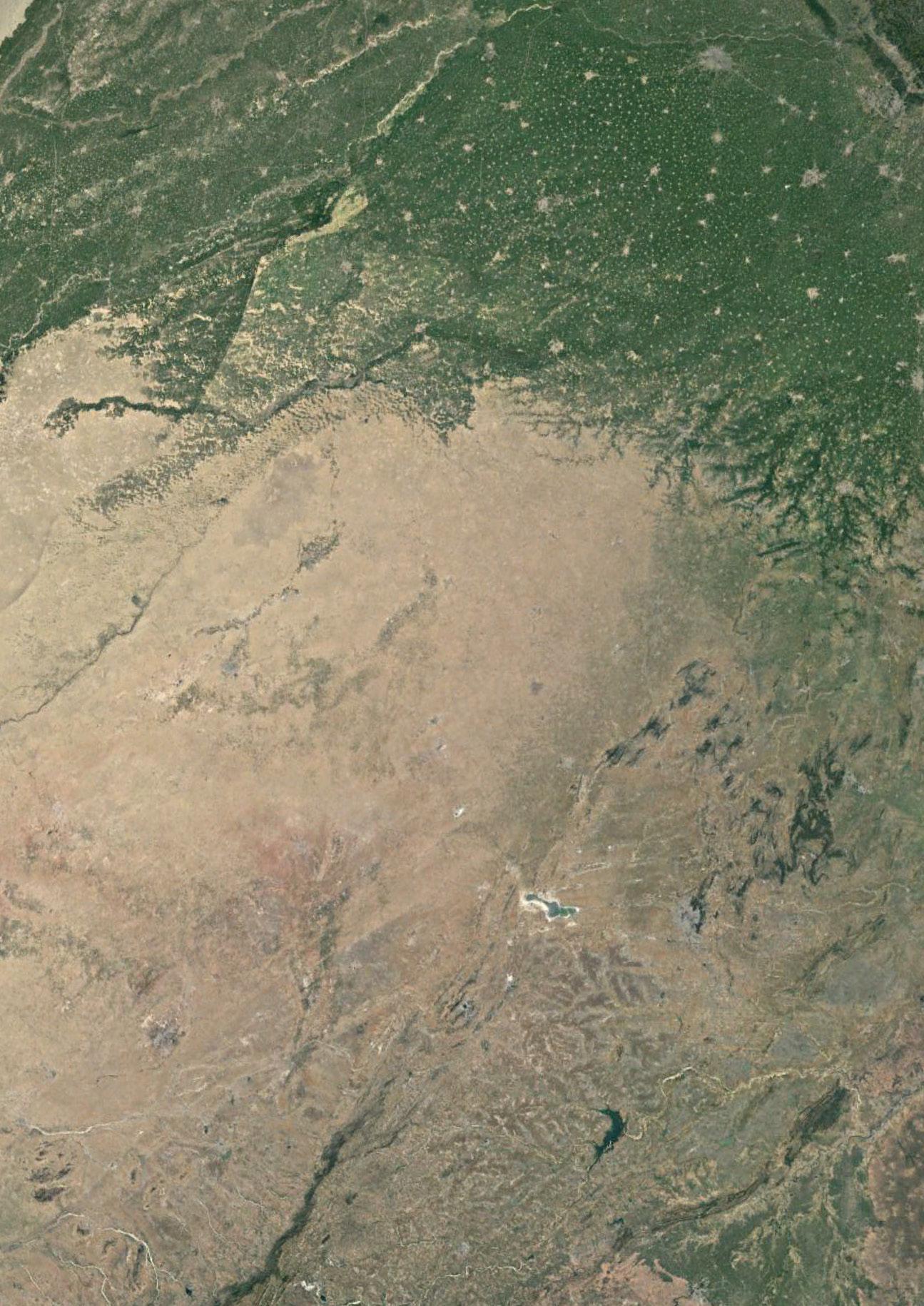
The Ganges River represents the dynamics of a mega river, being the largest river in India (see river location on Fig. 8) while it’s convergence with the Brahmaputra in Bangladesh also makes it among the largest rivers by discharge quantity worldwide. It is embedded in a long history of politics dealing with food security for the country, while also being in the center point of one of the world’s most ancient religions, where in Hinduism the river is seen as the physical manifestation of the holy goddess Ganga- the goddess of forgiveness and purification. In modern days, the river irrigates the most fertile valley of the Indian sub-continent while also providing nearly 500 million people with basic water needs daily within India and Bangladesh (World Bank, 2015). Yet, it also highlights problems of industrial progress and urbanization, as it is currently the most polluted river in the world. By studying the Ganges River Basin, the scope is broadened from a river to its entire water catchment area that forms the main river, dictates it’s flow while also giving insight into human capability to manipulate water and the future lives of all those that depend on the river and reside within it’s reach.

24 Ganges River in the Age of the Anthropocene
25 Introduction
Fig. 8: Map of India with Ganges River Basin region highlighted in light blue.
METHODOLOGY
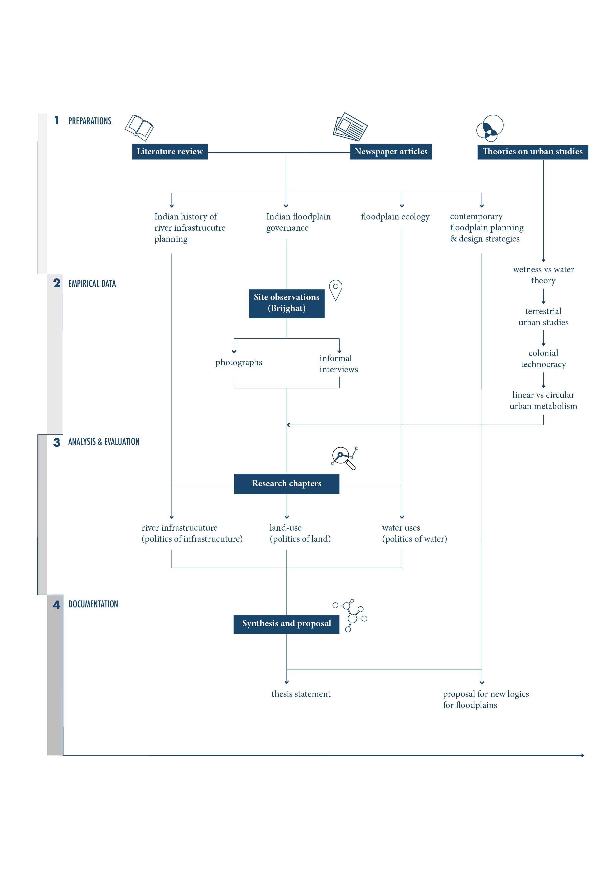
The thesis work is divided into four main components (visualized in Fig. 9):
The first is an ongoing process of constant literature review of relevant subjects such as floodplain planning and design, history of Indian river infrastructure planning, Indian floodplain governance and river and floodplain ecology.
The second component is a collection of empirical data through a site visit of one site along the Ganges river. Documented through a series of photographs and informal interviews, the main activities along the river at the visited site (Brijghat) were identified.
The third component of this thesis work consists of analysis and evaluation of collected material that has been compiled over the stretch of the research. By systematically evaluating specific instances in history and researching their effects on current practices within planning, development and politics in India, the aim is to understand the drivers of floodplain transformation in the realm of infrastructure, land-use conflicts as well as water use through river narratives of contested sites. The analysis is indexed into three overarching themes concerned with river politics categorized under politics of river infrastructure, politics of land and politics of water.
Lastly, the fourth component of the thesis work focuses on a proposal by identifying new logics of floodplain planning and development and mapping them as floodplain zoning strategies within one test site at Kanpur Metropolitan Area. By locating characters and challenges within a terrestrial condition that highlights power dynamics of stakeholders as currently present, the objective is to define a system within which negotiations can help reorganize stakeholders access and use of floodplains based on new logics of refuge and care to create productive and democratic Floodscapes. Designed as a system of democratic space making, the purpose of this thesis is to question the way all stakeholders of floodplains can have an equal chance to participate in the politics of floodplain design within the Ganges River Basin.
26 Ganges River in the Age of the Anthropocene
27 Introduction
Fig. 9: Diagram of thesis methodology.
28 Ganges River in the Age of the Anthropocene
THREE POLITICS OF RIVER
29
30
Ganges River in the Age of the Anthropocene
31 A
Photo showing the Luv-Kush barrage built on the Ganges River upstream from Kanpur City.
POLITICS OF INFRASTRUCTURE
A strategic disconnect in three stages
1600
1947
1990
British colonial rule in India
onwards
Independent Indian State Barrage construction in Kanpur
32 Ganges River in the Age of the Anthropocene
Fig. 10: Diagram of three stages of disconnect from natural floodplains.
Historically, the floodplains of the Ganges River Basin (GRB) underwent three significant transformations due to infrastructural ambitions driven by various political and economic factors over time (see Fig. 10). Starting with an analysis on a GRB scale to evaluate the impacts of the British colonial rule in India over its natural river system, the second transformation looks into Independent Indian States’ need for maximizing agricultural productivity at the cost of it’s floodplain communities. Lastly the chapter ends with a zoom in into a case study of a relatively recent barrage construction in Kanpur that has the ability to choke a river dry. Each transformation like a butterfly effect, becomes the cause of the following transformation, leaving the current condition of floodplains in a highly vulnerable state for both its inhabitant and river ecology alike.
33
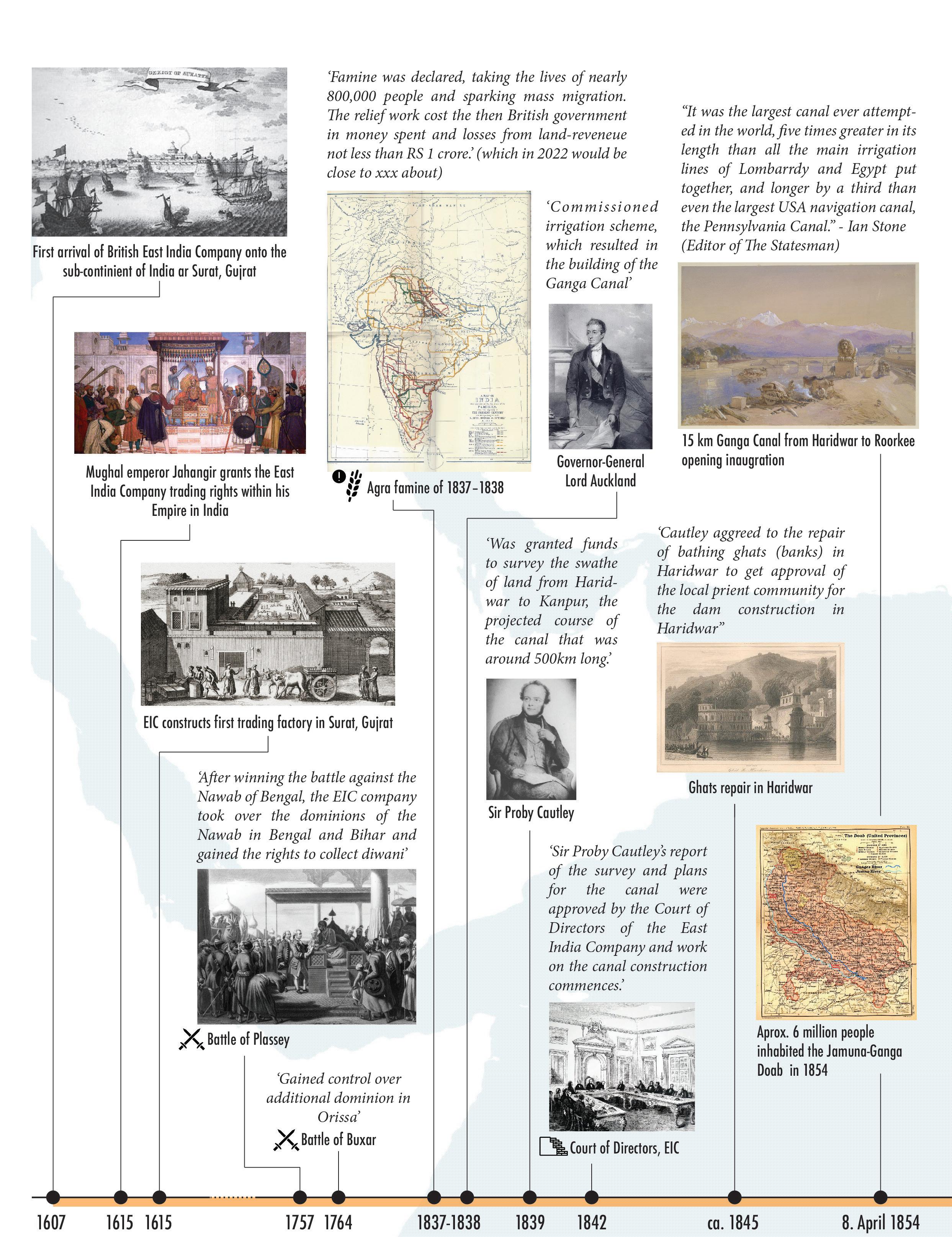
STAGE 1 (1600 - 1947): GANGES CANAL & THE BEGINNING OF AN ERA OF ENGINEERED LANDSCAPES IN THE GANGES RIVER BASIN
Starting with the arrival of the British East India Company in India (EIC) in early 1600, British occupation set the landscapes of the Gangetic plains on a course of irreversible transformation. What once were the densest forests of the Gangetic plains underwent rapid land transformations into one of the highest productive agricultural landscapes over a span of 200 years. No better image can be painted of such transformations as done in The demon of Cawnpore by Jules Vernes (1881: 200). In this fictitious work he conveys the zeitgeist of the Indian subcontinent as experienced by four British expats traveling through the country on a self-made Steam House in the form of a metal elephant, they wanted to explore ‘Hindoostan’ (1881:72), on a search for nothing less than to gain knowledge of the new land they were in. Painting page after page a picture of British rule in India, the storytelling and accompanying drawings (Fig. 11) give a clear picture of the British impact on the Indian landscapes:
‘We had no longer before us the rich plains of the kingdom of Oude. Steam House had now to pass through Rohilkund, a fertile territory, through much cut up by ‘nullahs,’ or ravines. Bareilly is the capital of this province, which is 155 miles square, well watered by the numerous affluents or tributaries of the Cogra; here and there are many groups of magnificent mango-trees, as well as thick jungles, which latter are gradually disappearing as cultivation advances.’
Untamed floods called in by the fierce monsoon winds were soon after tamed by British colonizers through raised embankments for new trade roads. The GRB underwent an unprecedented construction spur in river infrastructure driven by the ambitions of the EIC to maximize agricultural productivity and increase land revenues from the colonized lands of the fertile Gangetic plains. (Acciavatti, 2015)
In 1615 the EIC was granted trading rights by the Mughal Emperor Jahangir and build it’s first trading factory in Surat, Gujrat. Another 150 years later, it had surveyed and studied the lands of the Indian subcontinent well to understand the value and benefits of wanting to conquer it for it’s fertile agricultural lands and strategic trading ports.
34 Ganges River in the Age of the Anthropocene

35 Politics of Infrastructure
Fig. 11: Image from Jules Verne book ‘The Steam Engine - the Demon of Cawnpore’, 1880: 206.
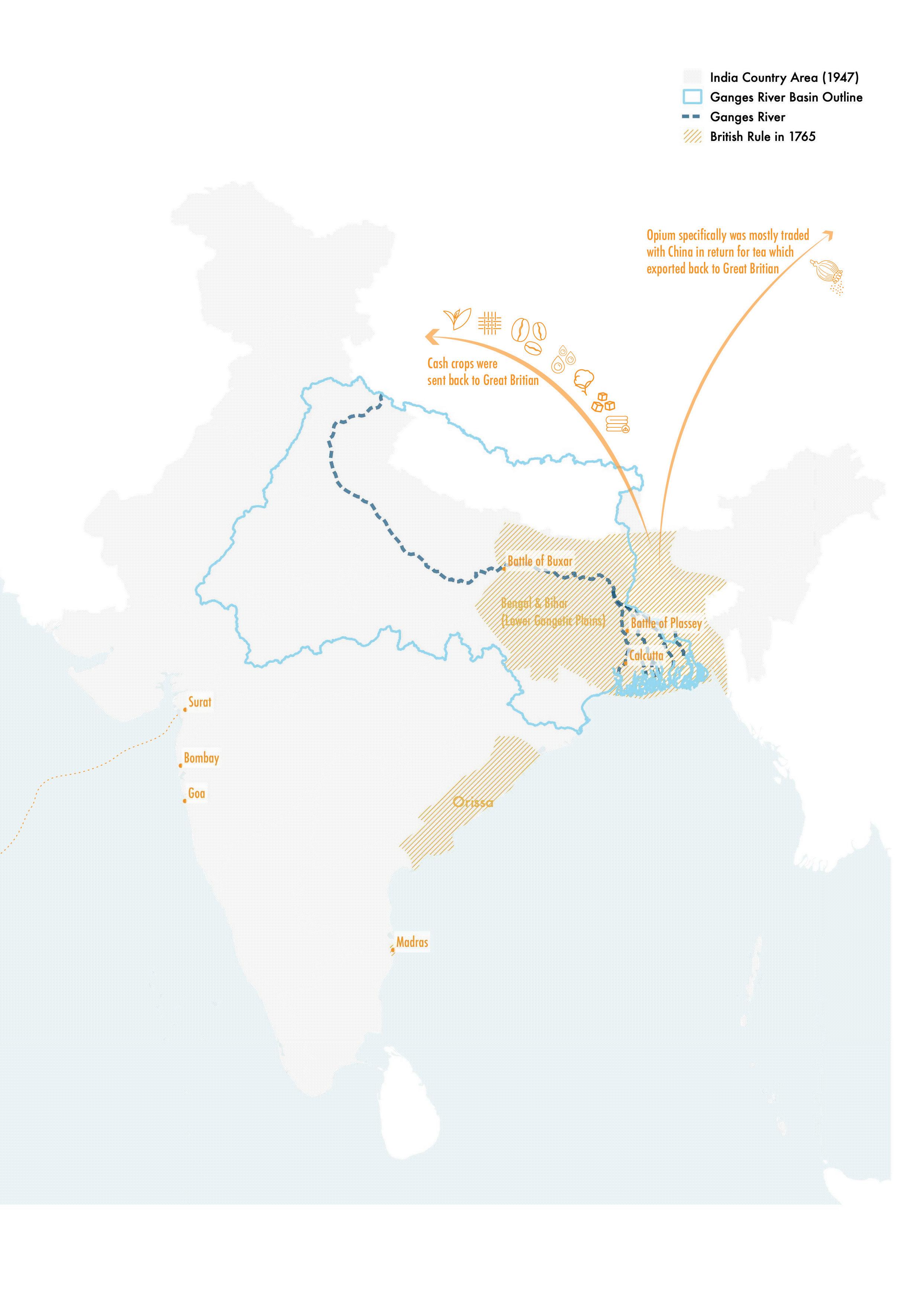
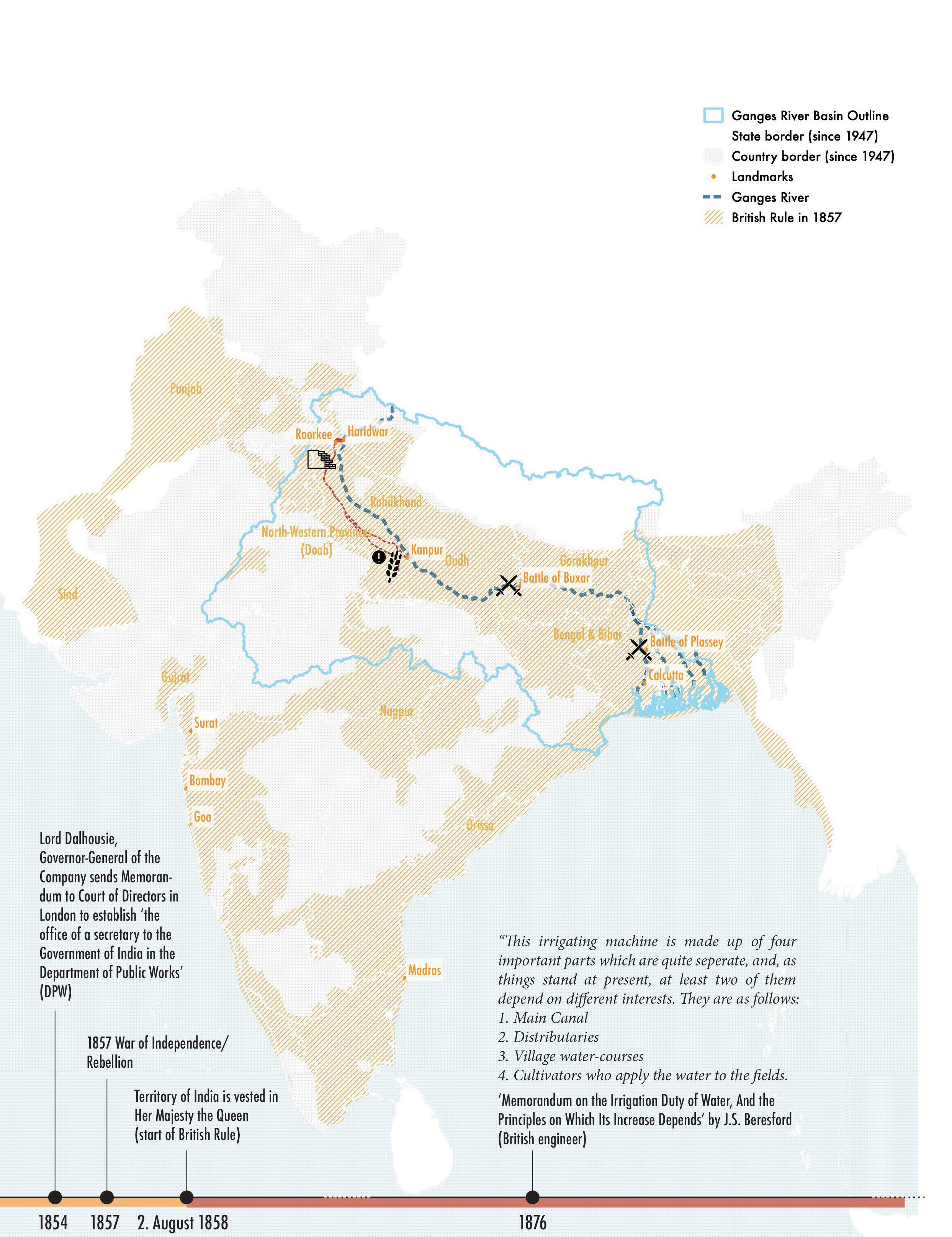
By 1757 the EIC had gained a large area of land after successfully winning the Battle of Plassey against the Nawab of Bengal, taking over his dominion and was granted the right to diwani (hindi term meaning right to collect taxes) in Bengal and Bihar and eventually also in Orissa after winning another Battle of Buxar in 1764. These strategic gains essentially gave the EIC the rule over the Lower Gangetic Plains (see Fig. 12). The occupation of these plains allowed the British to control agricultural activities of the regional peasants and steer them into growing cash-crops such as tea, coffee, sugar, opium, jute, indigo, silk and cotton in the fertile plains along the Ganges River (Washbrook, 2008; Lakshmi, 2017). To make sure the cash crops would provide a high return, many efforts of the EIC focused on maximizing the plains agricultural productivity, which started an unprecedented construction spur in river infrastructure throughout the region.
By 1800, the EIC had also gained grip over the regions of Bombay and Madras as well as the North-Western Provinces comprising of Rohilkhand, Gorakhpur, the Doab (hindi term meaning plains between two parallel rivers- in this case between Jamuna and Ganges river) and Delhi. In total all the conquered regions comprised close to 200 million hectares of land including 65 million hectares of a total of 86 million hectares within the GRB (Ganga Basin, (no date)). At this point in time, the British ruled over 75 percent of the total GRB area. The fertile lands within the GRB plains provided for large sums of revenues for the EIC.
But in 1837, one of the worst recorded famines of the region, known as the ‘Agra famine of 1837–1838’, became an awakening for the EIC. Delayed seasonal rains perished crops throughout the region. Spreading over an area of 6.5 million hectare, the famine affected approximately 8 million native lives and starvation eventually also lead to approximately 800,000 casualties. These losses created a twofold revenue loss for the EIC (Major, 2020). Along with the cost of relief work, the loss of land revenue of the year was so great that it set in motion an ambitious course to design one of the biggest irrigation networks of the time to provide revenue security from unpredictable rain patterns (Acciavatti, 2015: 115). Their goal was to reduce the agricultural area dependent on rain and instead provide an opportunity for farmers to irrigate their land from canal network by subscribing to various irrigation schemes offered along a centralized water supply network. While these irrigation schemes were not new to India, as earlier, local authorities (often wealthy families within a region) provided privatized forms of irrigation infrastructure which could be accessed in return for takvi, in hindi a term relating ‘to government loans to assist cultivators to finance improvements’ (2015:115). Yet, the British centralized such an irrigation system through the construction

36 Ganges River in the Age of the Anthropocene
37 Politics of Infrastructure
Fig 12: Timeline of British East India Company’s ruling area in India by 1765.
of canals, collecting takvi from all who wanted to access water from it. This way, not only were land revenues secured but also an additional source of revenues was created for the EIC through the newly set up irrigation schemes of the canal network.
By redistributing the water flow from the Himalayas to the dryer plains between major rivers that mainly depended on rain to irrigate farmlands, known as doab in Hindi, these fertile lands between two converging rivers were especially susceptible to famine if the seasonal rain didn’t arrive on time. To avoid another large scale catastrophe such as the Agra Famine, the EIC gathered funding to build their own canal network within their dominions in the Ganges River Plains.
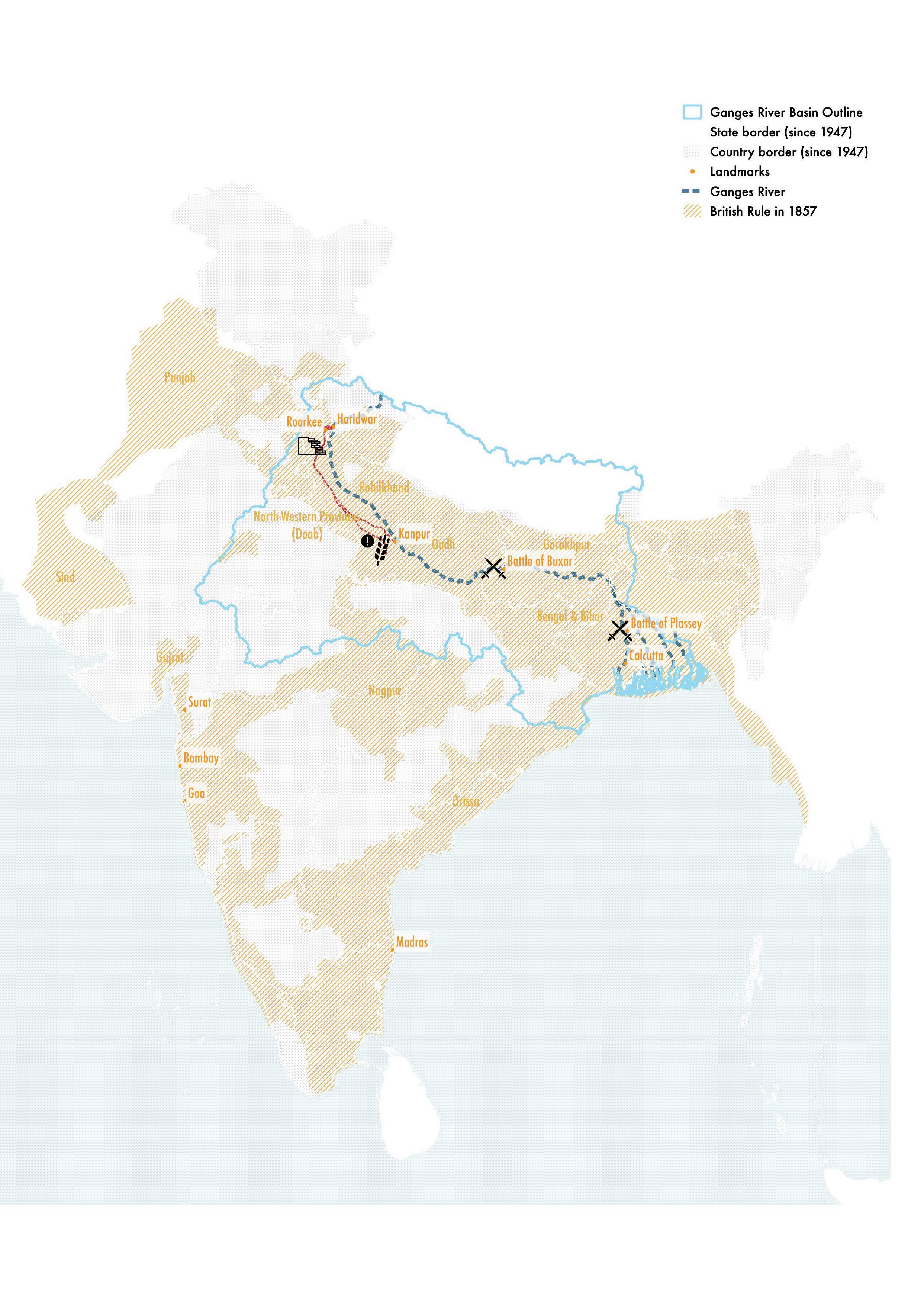
By 1842 construction work on the canal finally commenced and by 1854, nearly 12 years after, the first leg of the planned canal network was completed. The first 560km stretch of the canal started from the holy city of Haridwar through the small town of Rorkee and all the way to Kanpur city (see red dashed lines in Fig. 13). The canal network within the Ganges-Doab region alone was recorded to be close to 6000 km by early 1900 (Wood, 1907) with an initial discharge capacity of 170 cubic meters per second (cumec) to 295 cumec in present day. Along with the canals, the EIC built dams and barrages to calibrate water levels and water quantity within the main river as well as in the canals to create a stable flow of water throughout the year and provide regions of dry-land a secure source of water supply. Such an engineered system also provided the EIC with a stronger control over rural communities through a systematic building up of dependency of rural communities to an irrigation network they controlled.
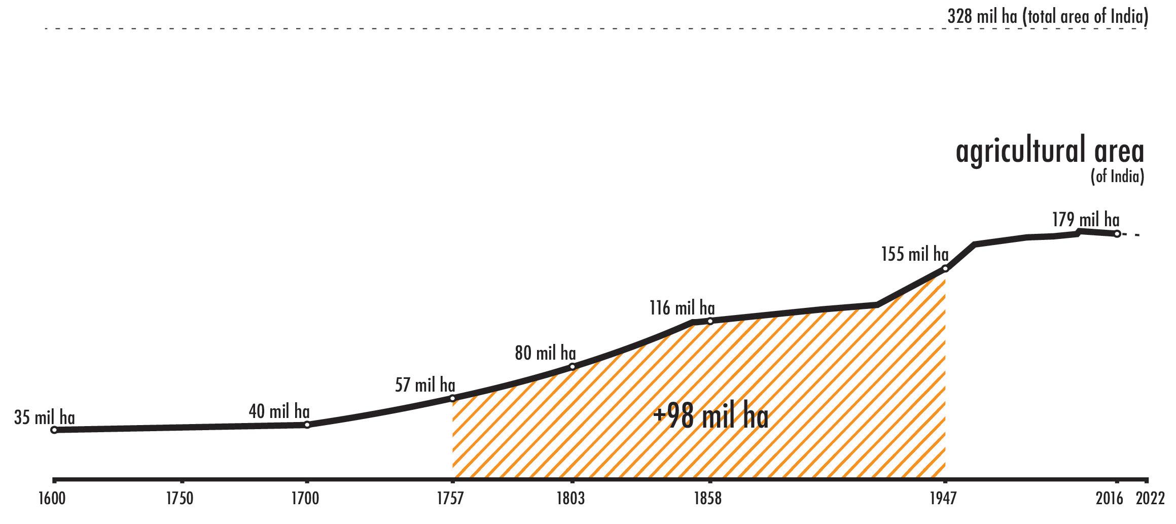
The newly calibrated Ganges River with the help of river engineering, had a broader reach of irrigated land, increasing the total agricultural land throughout India by 300% from around 57 million hectare in 1750s when they first acquired rule over the regions of Bengal and Bihar to 155 million hectares in 1947 when India got it’s Independence from British Rule (see Fig. 11). (Ritchie and Rosner, 2017; Agricultural land (sq. km) - India, The World Bank | Data).
In 1864, the inauguration of the canal’s 560 km stretch from Haridwar to Kanpur made it the largest planned irrigation network worldwide at the time. Even though the concept of a canal as an irrigation network was not entirely new in it’s invention to the sub-continent of India as the British incorporated many of the old water structures already built by the Mughal emperors and updated and integrated them into the extensive network they had planned, the built scale of the ‘Ganga Canal’ was at a new level of engineered projects by the British (see

38 Ganges River in the Age of the Anthropocene
Fig. 11: Timeline of British East India Company’s ruling area in India
39 Politics of Infrastructure
Fig 13: Timeline of British East India Company’s ruling area in India by 1857.
Fig. 14). The canal network was referred to as an irrigation machine by J.S. Beresford, the head engineer of the Ganga Canal. Acciavatti (2015: 128) later noted how such an infrastructural system reorganized and embeded prescribed human labor duties within its logics as stated in the ‘Memorandum on the Irrigation Duty of Water, And the Principles on Which Its Increase Depends’ written by Beresford (1876):
‘This irrigating machine is made up of four important parts which are quite separate, and, as things stand at present, at least two of them depend on different interests. They are as follows:
1. Main Canal,
2. Distributaries,
3. Village water-courses,
4. Cultivators who apply the water to the fields.’
As the title of the memorandum already indicates, the motivations of the EIC was to actively recruit farmers to subscribe to their canal network to ensure a twofold revenue source. Through the collection of revenues in the form of takvi from farmers, the EIC could fund the expansion of their canal construction, and through the prescription to a reliable irrigation scheme, farmers could successfully grow cash crop, thereby increasing the second revenue source of the EIC.
Lastly, in addition to an expanding canal network through the vast rural countryside of India, the East India Company also built embankments along the rivers to protect the expanding network of roads and railways the Company relied on for strategic trade routes within a network of cities. These embankments were meant to stop any overspill of water from the river which could slow down the mobility of any commerce or military endeavors. Yet, these embankment not only protected the roads and railway tracks from overspill, but also gave a false sense of security to nearby inhabitants to move closer into the floodplains as they saw in river infrastructure meant for irrigation, an essential river protection mechanism as well.
40 Ganges River in the Age of the Anthropocene
41 Politics of Infrastructure
Fig 14: Timeline of British East India Company’s ruling area in India by 1947 with major canal network drawn in red.
By the time the British left India in 1947, a new engineered landscape of canals, dams, barrages, and embankments had redefined the natural river valley within the Ganges River Basin. New river infrastructure logics set up during a 250-year long rule had caused significant transformations to river landscapes which now also had redefined the floodplains and its adjacent activities as following (see diagrammatic transformation sketches in Fig. 15):
[T-1] As showcased within the stories by Jules Verne (1881) along with the timeline of systematic agricultural land acquisition of 155 million hectares by the EIC, mostly forests and wetlands of the fertile Gangetic plains were converted into new cultivation land for cash crops.
[T-2] The construction of canals and dams shifted the dependency of farmers from unpredictable weather patterns towards the ‘gora nawabs’, meaning white colonizers in Hindi, who gave them access to a more stable source of water through a centralized irrigation machine which they had control over leading to new logics of dependency within what Malterre-Barthes (2016) claims as a form of ‘colonial technocracy’ where technological solutions brought in by colonizers also dictate new logics of resource extraction as well resource repletion of a region.
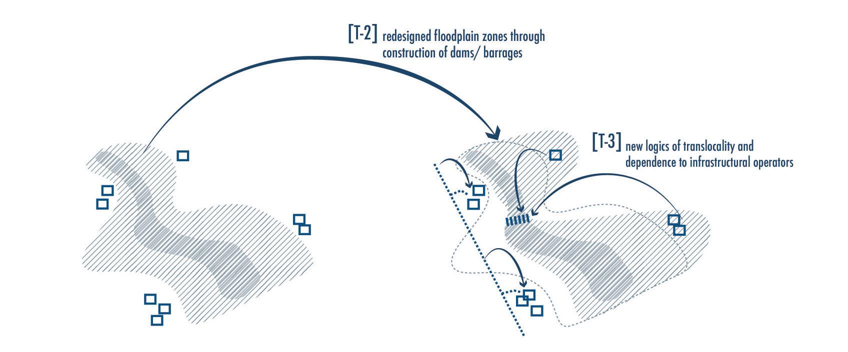
[T-3] Through this, not only a dependency to a new central regime was built, but river infrastructure became the tool by which new logics of trans-locality dictated agricultural activities, spacial cohesion within distant lying rural parts of the empire, as well as natural flood zones were redefined by controlled and planned flood zones
[T-4] As canals were able to take in access water during monsoon season, gently sloping floodplains along rivers were no longer necessary to provide areas for river swellings. Instead, the newly built embankments could capture higher water levels while keeping banks dry yearround.
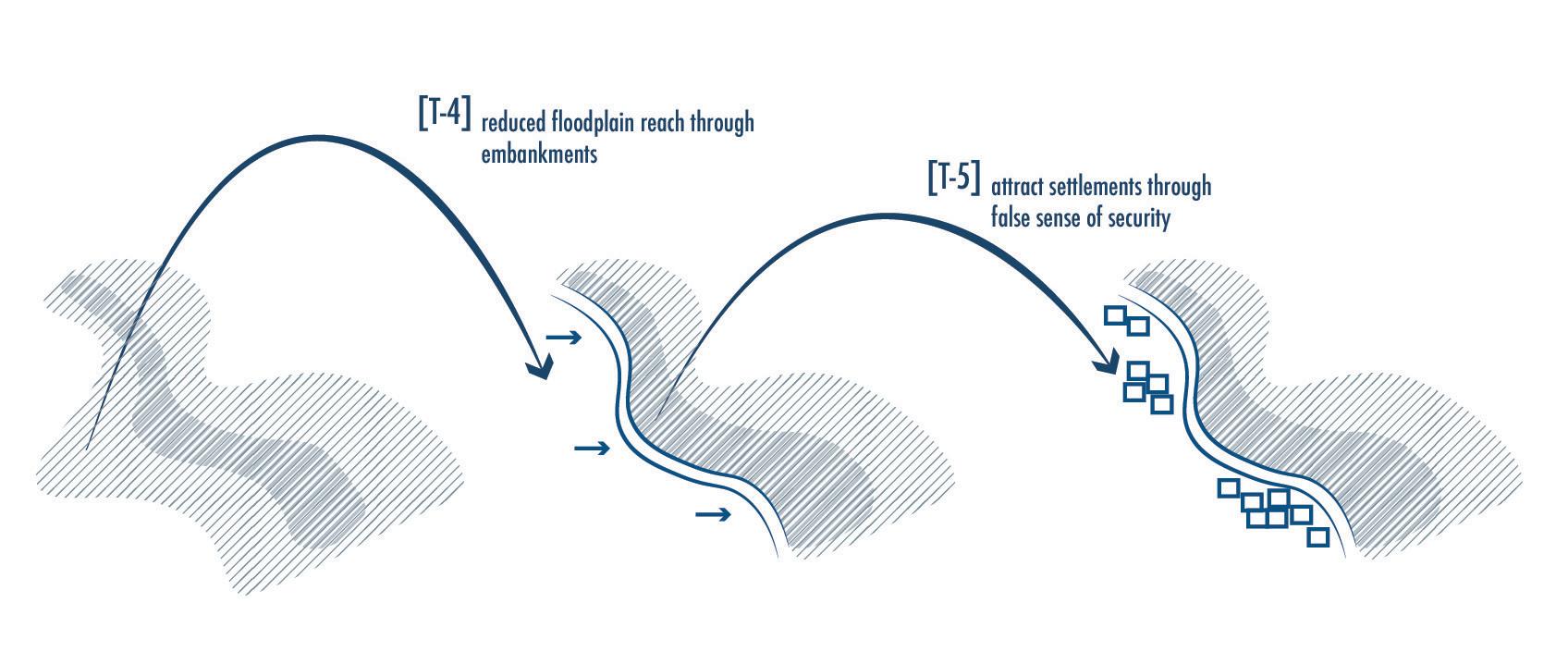
[T-5] As the dependency on engineered landscapes grew and embankments became common practice along major stretches of the river, it instilled a false sense of safety for urban dwellers and new settlers of a region who felt that ‘river protection’ infrastructure would provide for them a stable land to settle into, making floodplains a notorious site for both formal as well as informal settlements along rivers at the outskirts of major cities in India. This new paradigm of safety made making floodplains vulnerable to ever greater human activities and settlement encroachment.
42 Ganges River in the Age of the Anthropocene

43 Politics of Infrastructure
Fig. 15: Diagrams of river landscape transformations
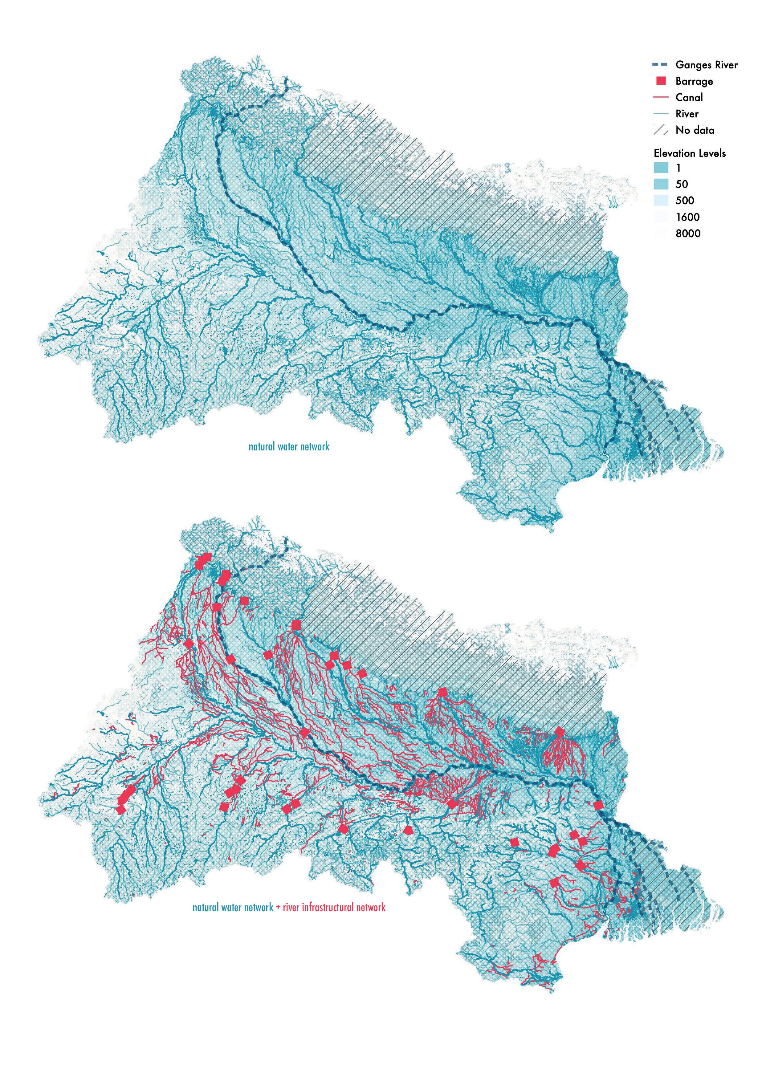
Ultimately a mostly natural river network was re-calibrated during the British Rule into a water network governed by new logics of a river infrastructural network (see comparison in Fig. 16).

44 Ganges River in the Age of the Anthropocene
45 Politics of Infrastructure
Fig. 16: Diagrams of river basin transformation from a natural river network to one governed by a river infrastructure network.
46
in the Age of the
Ganges River
Anthropocene
47 Politics of Infrastructure
Fig. 17: Timeline of main events of the Ganga Canal project during British rule in India.
STAGE 2 (1947 - CURRENT): INDIA’S GREEN REVOLUTION & THE RISING DISPARITY IN STATE SUBSIDIES BETWEEN IRRIGATED AND RAIN-FED AGRICULTURE
Till the end of the Company Rule and through the British Rule, the canal network within the doab was consistently expanded to increase agricultural productivity. As the British Rule was coming to an end in the 1940s, Indian supplies were being sent home to Britain to support their own people during World War II in Europe, while hiding news of constantly occurring famines in their colonized countries in Asia, such as the Bengal Famine of 1943, where millions were starving as their rations were send overseas by the British (Doctor, 2020).Yet, as most of the grown crops under the British Rule were cash crops, the young country of India not only gained it’s independence in 1947 but also inherited a starving country unable to feed itself. With a population of close to 340 million people in 1947, the young independent nation was born hungry and still very much relied on traditional methods of farming:
‘For a few centuries, Indian agriculture remained unchanged without any technological changes in agricultural practices. The technologies employed in agriculture were the seeds cultivated by the farmers having a genetic makeup that went back thousands of years and the involvement of wooden plows, waterwheels, and bullock carts, along with the agricultural practices driven by the energy provided by animals and humans.’ (Nelson and Ravichandran, Anthony, 2019)
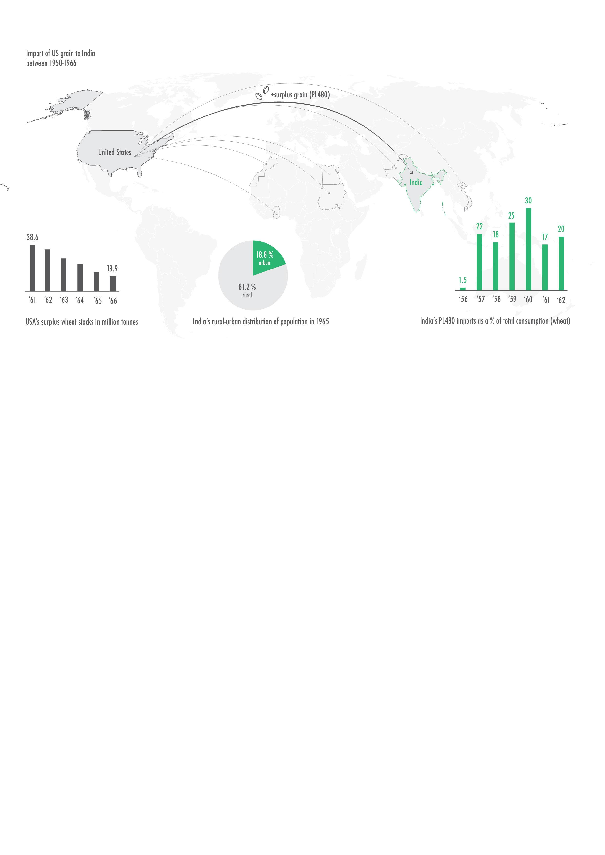
The leaders of the newly independent country in 1947 were struggling to find ways to increase food grain production and every few years, a bad monsoon season would set them further back. The USA was observing the situation of India and by 1950 offered to send their surplus grain produced in their own country to developing countries in Asia, India being
48 Ganges River in the Age of the Anthropocene
Fig. 18: Global drivers of agricultural reforms in India till 1966.
one of them (Fig. 18). In hopes of building stronger allies in the region as the trend of young independent Asian countries were oftentimes turning to a communist governance system rather than a democratic one as the USA had preferred, it send from 1950 till 1966, their surplus produced grains to India at highly discounted prices under an act called Public Law 480 (PL480). But in 1960s, they realized their allies were using the saved-up money from crop production to fuel their internal conflicts with Pakistan and wouldn’t side with them as allies in conflicts such as the Vietnam War. In retaliation, the USA threatened to stop the grain supply under the PL480 act, which by 1962 made up almost 20% of India’s grain consumption. (Did India Need the Green Revolution?, 2021)
By 1966, the USA grain surplus stock fell from 38.6 million tonnes to 13.9 million tonnes and it urged India to introduce agricultural reforms to become self-sufficient through the implementation of modernized techniques of agriculture (also known as industrialized methods):
‘the Green Revolution involved the use of HYVs of wheat and rice and adoption of new agricultural practices involving the use of chemical fertilizers, pesticides, tractors, controlled water supply to crops, mechanical threshers, and pumps. The combination of these techniques was commonly termed as “high-yielding variety technology (HYVT)’ (Nelson and Ravichandran, Anthony, 2019).
This in turn reverted the role of USA from acting as grain donors to business partners in the modernizing agricultural sector of India (Fig. 19). With this new partnership, the Green Revolution had arrived in India by mid 1960s. India would buy the high-yielding variety seeds (HYV) from USA along with the necessary fertilizers and pesticides mainly produced in USA at the time.
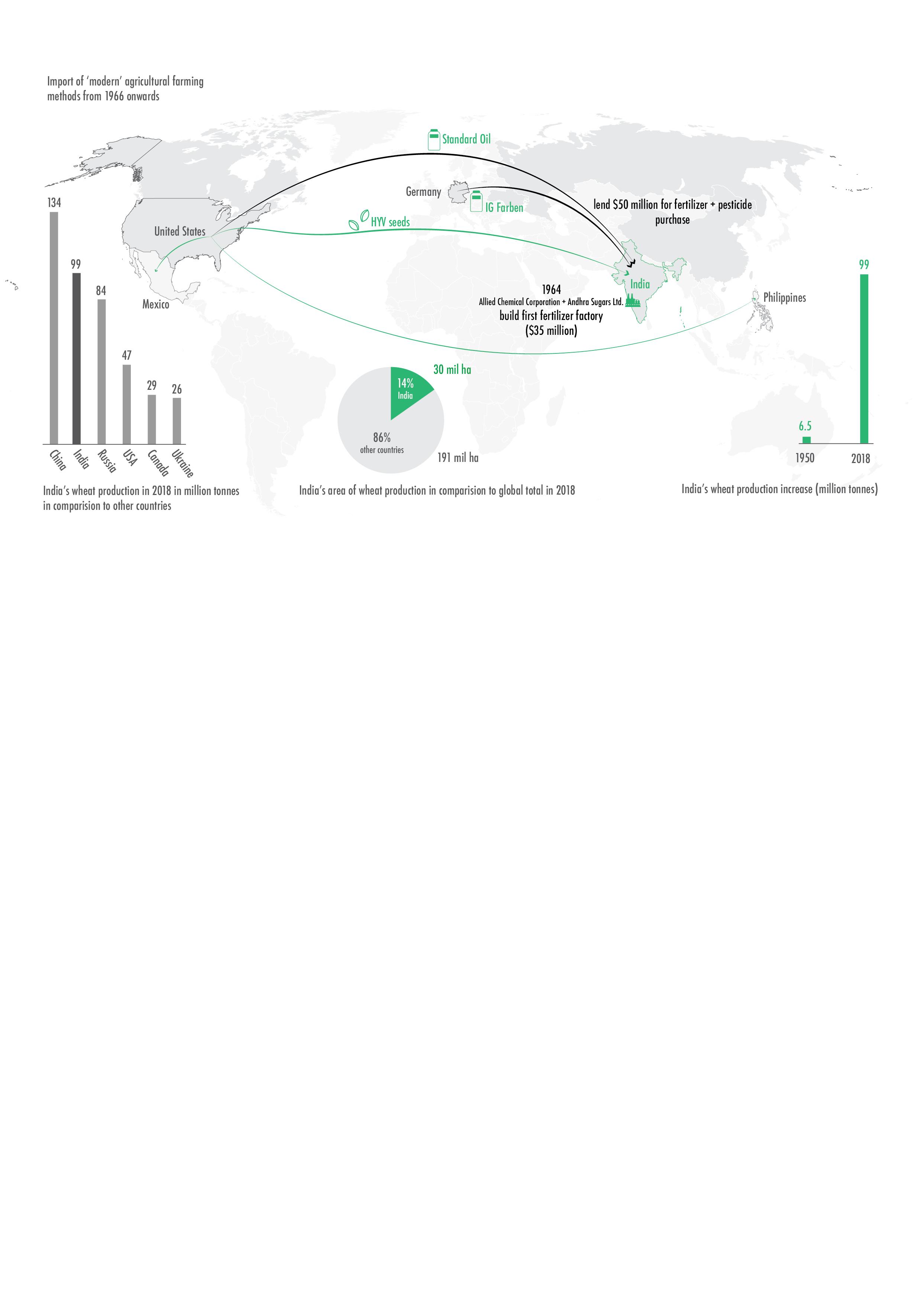
49
Fig. 19: Global drivers of agricultural reforms in India after 1966.
Politics of Infrastructure
With the inheritance of a very extensive canal network from the British Rule, India was well equipped to take on these new HYV seeds which relied on an industrialized irrigation system and farming methods rather than rain-fed farming methods. First implemented in the state of Punjab and Tamil Nadu, where the British had their main agricultural colonies, the HYV seeds proved to be successful and were soon after also distributed along other areas that had already an existing infrastructure of irrigation canals, such as the Doaab and along the rest of the Gangetic plains further south-east (Did India Need the Green Revolution?, 2021). Many farmers were urged to convert their farmland and use the irrigation schemes of either the centralized canal network or decentralized schemes offering subsidies for tubewell construction, in order to grow food crops of mainly wheat and rice based on the HYV seeds. The Indian State focused on implementing stronger monetary effort towards irrigated agriculture, subsidizing farmers with lower cost of water and electricity if they switched over to HYV seeds, chemical fertilizers and pesticides. These efforts increased wheat production in India from 6.5 million tonnes in 1950 (Wheat, 2018) to 99 million tones by 2018, making it the second largest producer of wheat worldwide (Ramadas et al., 2019) (see Fig. 19 for top six wheat producing countries of 2018).
The new HYV seeds allowed farmers to produce twice as much yield per hectare in comparison to any local seed variety. But even though HYV seeds could amount for higher output in shorter amount of time, they also required almost twice as much water at very regular intervals, something that was only possible through irrigated farming and not rainfed farming. To implement these new HYV seeds, the state focused once again on the canal infrastructure they had inherited from the British. But even as HYV seeds had almost a double yield per hectare at close to 2200 t/ ha, compared to conventional seeds that would only produce around 1100 t/ha, the HYV seeds also required almost triple the amount of water of about 1500 l/kg compared to conventional seeds that needed about 500l/kg. This meant, farmers already connected to irrigation infrastructures along the northern plains of the GRB, were highly subsidized and financially supported while an ancient old system of floodplain farming slowly started to get neglected and became vulnerable to exploitation (Did India Need the Green Revolution?, 2021).
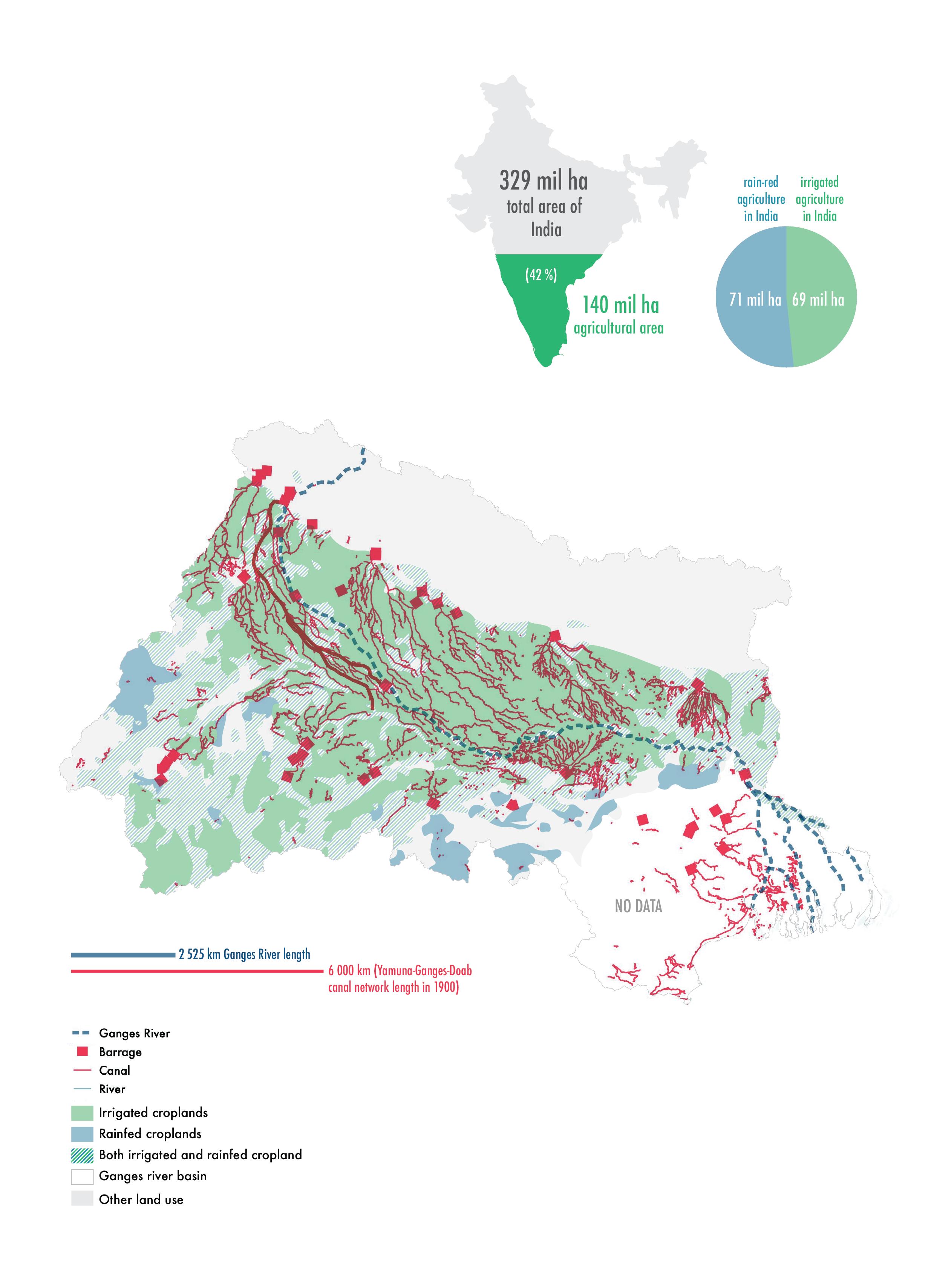
Currently in India, out of a total of 140 million hectare agricultural land in 2020 (making up 42% of total land area of India), about 69 million hectare land is currently classified as irrigated area, and 71 million hectare remains under rain fed (see Fig. 20 for location of areas under irrigation vs. rainfed farming).

50 Ganges River in the Age of the Anthropocene
51 Politics of Infrastructure
Fig. 20: Map of irrigated agriculture (green) vs rain-fed agriculture regions (blue) within GRB.
Thus, legacy of the Green Revolution left behind two main impacts on the floodplains:
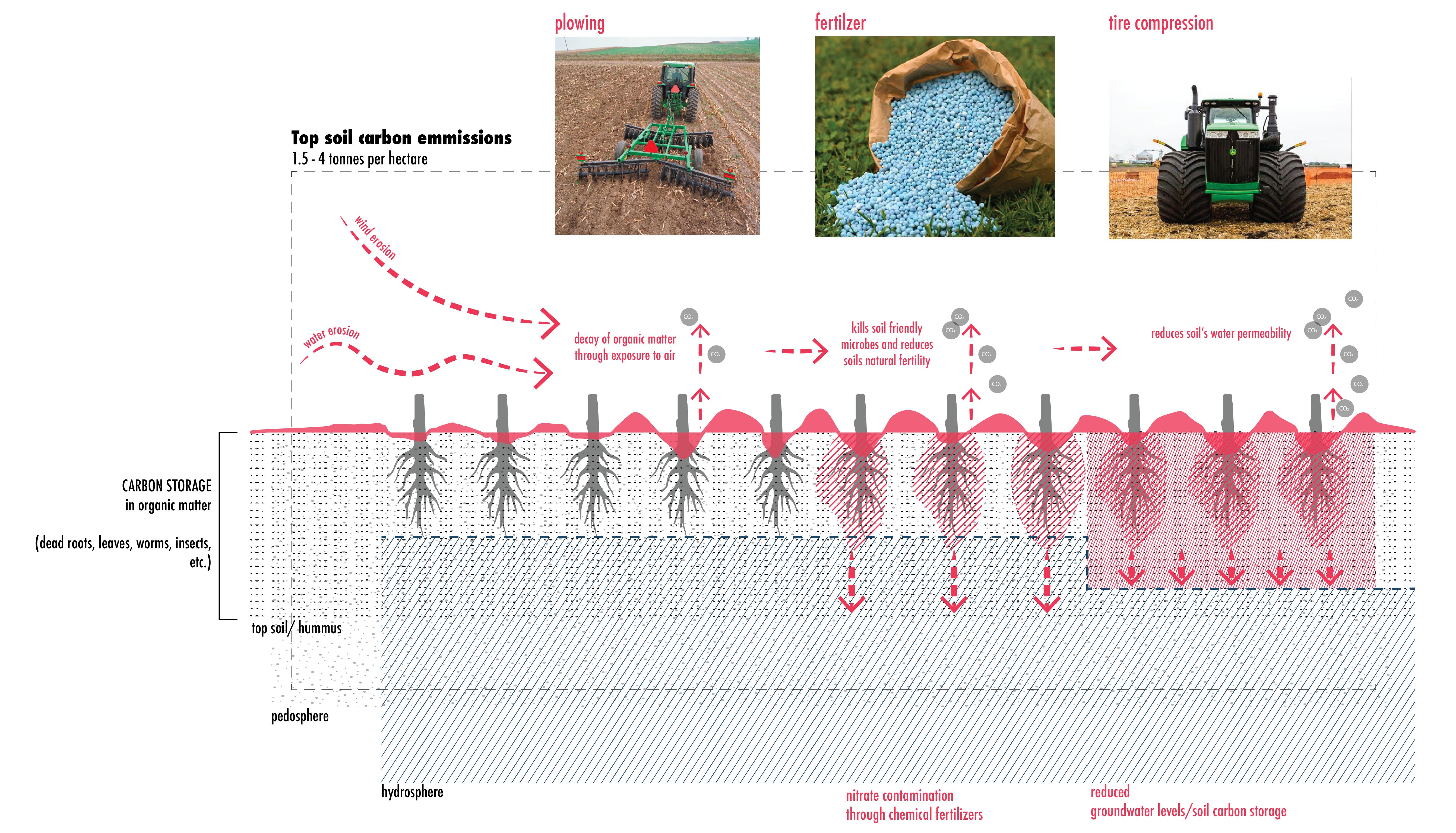
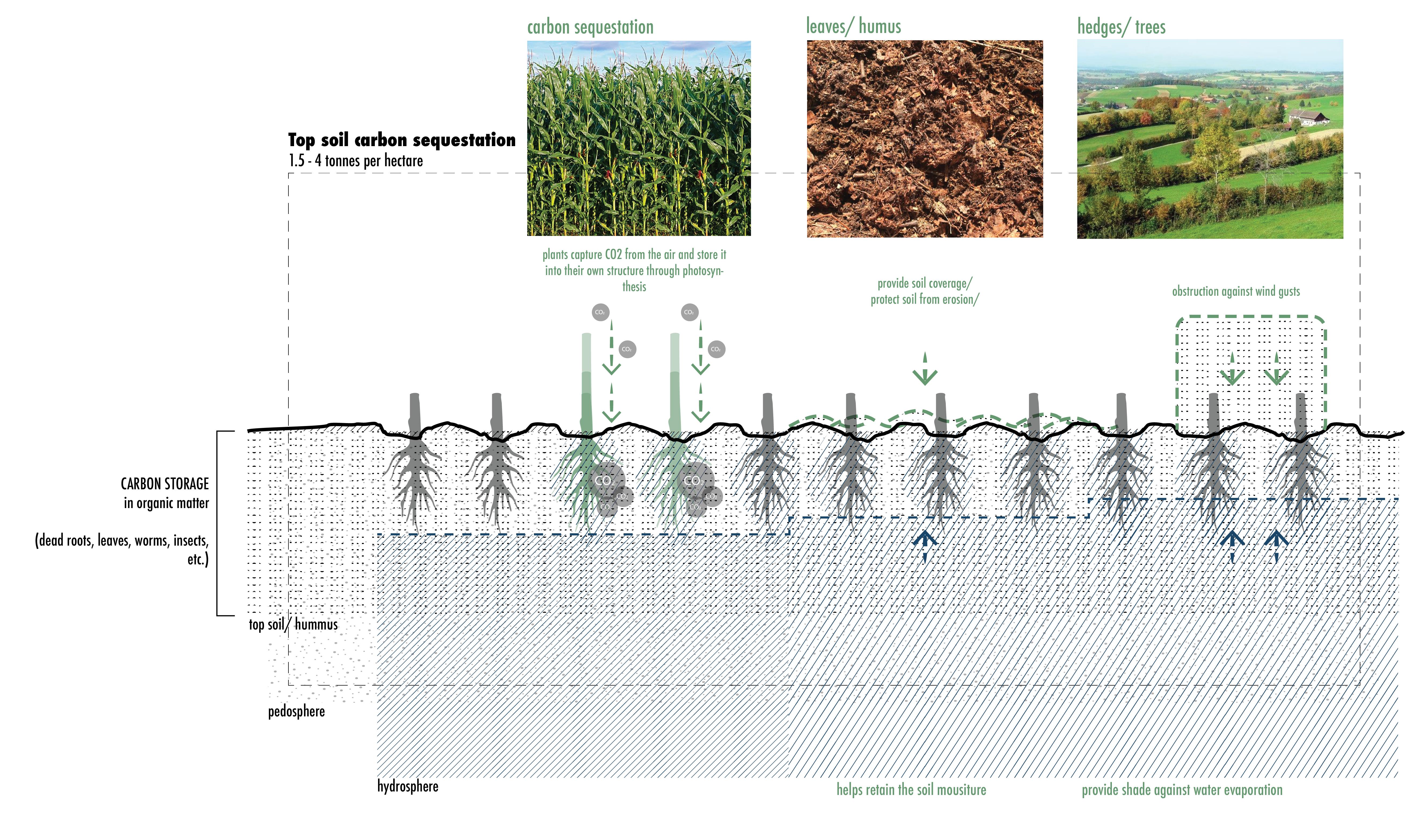
First, it tied the independent nation of India to a continued cycle of dependency to a network of river infrastructure, which they needed in order to sustain the new HYV seed crops and it’s extensive irrigation demands, continuing and intensifying the transformations triggered by the Ganga Canal construction in Stage I. But even as these new policies and subsides focused on higher crop yield for food security of the nation, they neglected the side effects of industrialized farming (see Fig. 21). In the long term industrialized methods of farming can lead to soil degradation, resulting in overall decline of arable land in India, while sustainable methods of farming can sustain soil health and assure its ability to store carbon at a rate of up to 1.5 to 4 tonnes of carbon per hectare within organic matter found in soil (Wall and Lanigan, 2020).
Second, it instated a policy framework which created an ever growing disparity gap by promoting farming communities based on irrigated agriculture with high subsidy schemes and neglecting farming communities based on rain-fed agriculture, leading to many forms of vulnerabilities within the latter communities. Neglected by law and planning departments who set no legal status of floodplain land uses, left these areas largely undefined in terms of ownership rights, under surveyed and susceptible to land grabbing and evictions (explained further in chapter on Politics of Land) by different government ministries and more powerful private stakeholders (Dutta, 2015). Furthermore, oftentimes without any legal land-use status or even full citizenship right with no permanent addresses, floodplain communities suffer from large debt build ups from a bad crop and monsoon season, and if unable to feed their families and pay back money lenders, it leads them to many actions of desperation, and in the worst case even suicides (Silk, 2022).
52 Ganges River in the Age of the Anthropocene
[industrialized farming methods]
[sustainable farming methods]
53 Politics of Infrastructure
Fig. 21: Impact of industrialized agricultural practices on soil health vs. sustainable farming practices.
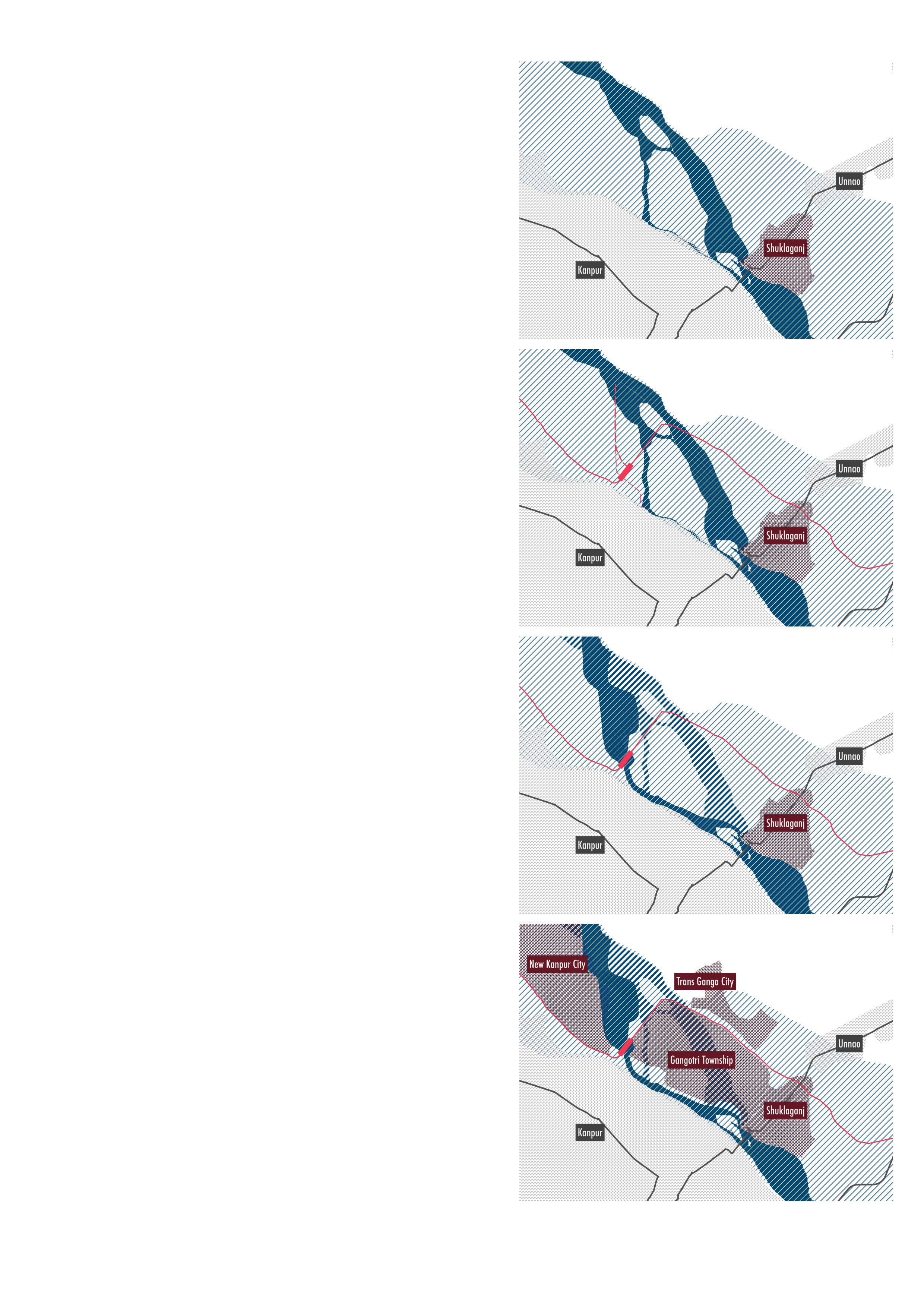
STAGE 3 (2022): BARRAGE CONSTRUCTION AT KANPUR CITY
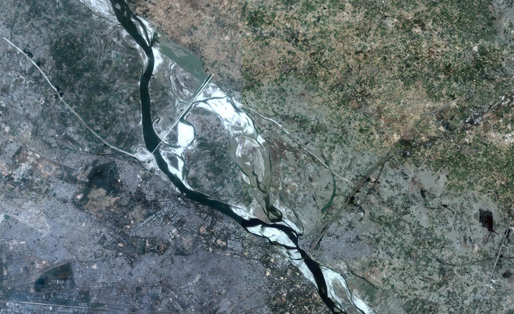
The third stage of floodplain transformations was no longer a national enterprise concerned with economic gains of colonizers or social concerns of food security of the national leaders but rather a local one concerned with water security of rapidly growing cities along the river. A rising trend of urban migration is creating an increasing pressure on cities to supply portable water to it’s rising number of residents. But dense urban regions are not only struggling to keep up with their inhabitants current water demands but must resort to technical solutions to secure future water security for the region as well. One such example of high water demand pressures on rivers can be studied in Kanpur City.
Kanpur city is Uttar Pradesh’s largest city with close to 3.2 million inhabitants, while also hosting the states largest leather tannery and textile industry. The Ganges river defines the north-eastern border of the formal city of Kanpur, but till the early 2000s it faced very little infrastructural obstructions and was freely able to carve it’s own path and meander naturally over the years within a mostly rural agricultural setting. Yet, this natural meandering of the river led the main stream to wander away further eastwards from the city, creating a problem for the city who heavily relied on the river for it’s daily water needs of it’s inhabitants (Gupta, 2005). The cities formal water infrastructure for water supply and wastewater treatment covers less than 30% of the cities total domestic needs, and none of the industrial water needs, making the river and groundwater aquifers the direct source for the majority of the cities inhabitants who would extract water from tubewells and dump wastewater through open rainwater drains on the street level back into the river untreated. (Bassi, 2019)
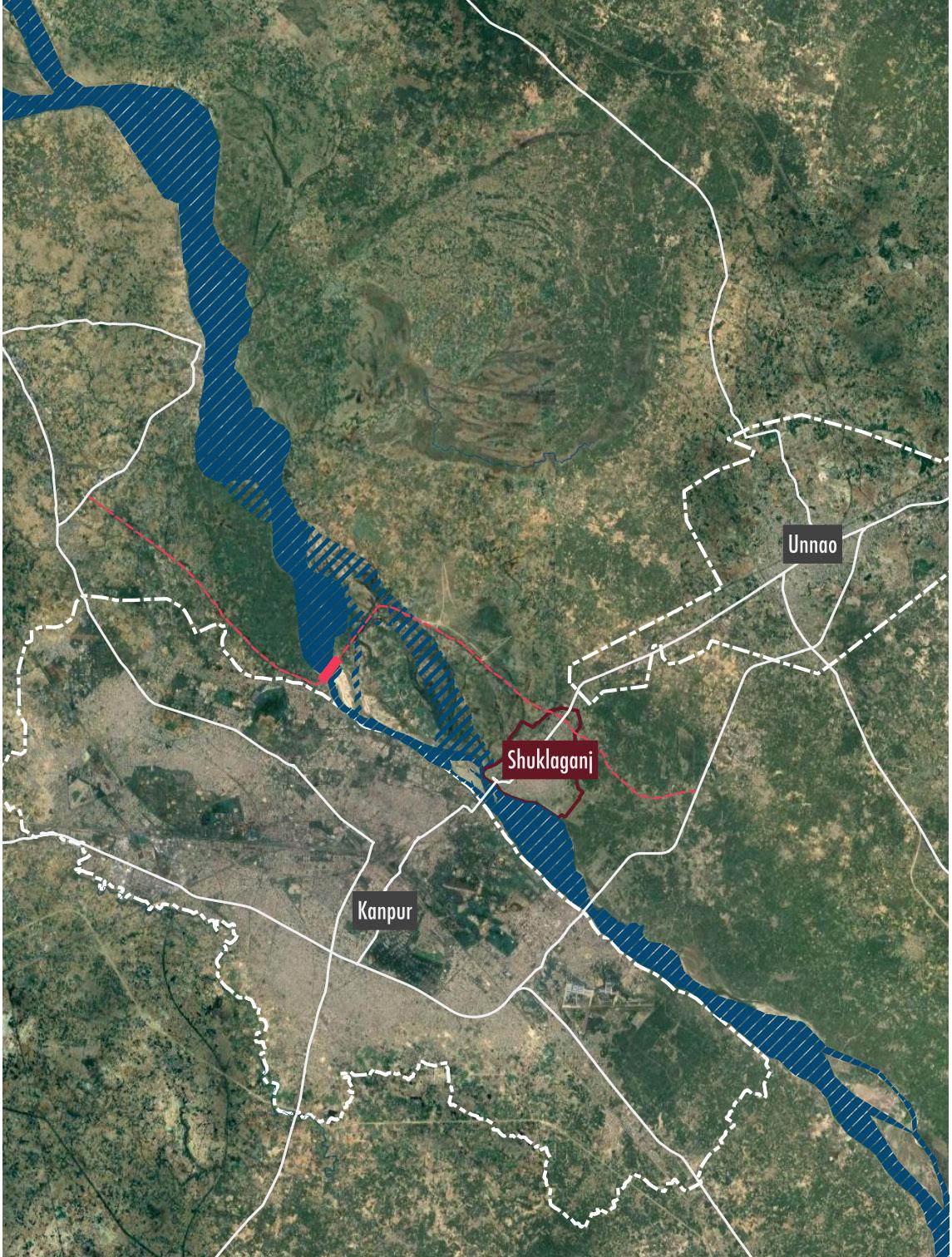
In 1990, the river had meandered eastward by almost 4km away from Kanpur city, leaving its Ghats (banks) almost dry all year long (see Fig. 23 on next page). The city’s banks, important ceremonial sites for Hindus were a key attraction for both tourists visiting the holy river and for locals of the city who visit the banks routinely for ceremonial baths or to enjoy it’s sighting in leisure time. Additionally, the river’s stream also served as a convenient wastewater disposal method for nearby neighborhoods as few of them were connected to the cities formal wastewater infrastructure. As the river meandered further away, wastewater canals had to be constantly extended in order to reach the main river stream. So by 1993, the city authorities along with the irrigation department of the state decided to plan a large scale infrastructural project to tame the natural meandering and redirect the river back to its previous path along
54 Ganges River in the Age of the Anthropocene
55 Politics of Infrastructure
Fig. 22: Google Earth areial image of Kanpur City region, showing in red the barrage and new highway construction area location.
the banks of Kanpur in order to secure the water demands of a growing city. (Gupta, 2005)
The plan was to construct a barrage slightly upstream from Kanpur City and build out the remaining small stream of the Ganges River that was still flowing occasionally towards the city into an artificially straight and deeper riverbed canal which would have the capacity to take up the full quantity of the river once engineers directed the flow of the main river back towards the banks of Kanpur.
By 1995, the construction of an artificially deeper riverbed channel and the barrage began, with the aim of controlling the water flow in both dry and wet seasons along the banks of Kanpur City (see Fig. 22). The anticipated goal was for the deeper channel to generate higher water flow velocity which would allow the river water to consistently re-carve the same path along the banks and naturally avoid any future meandering. To gain supporters for this pricey enterprise, the project was presented in the media as a noble undertaking of bringing back the ‘holy river’ to the banks of the city, a strategy which was highly supported by inhabitants but sparked high concerns amongst scientists and environmentalists. (Gupta, 2005)
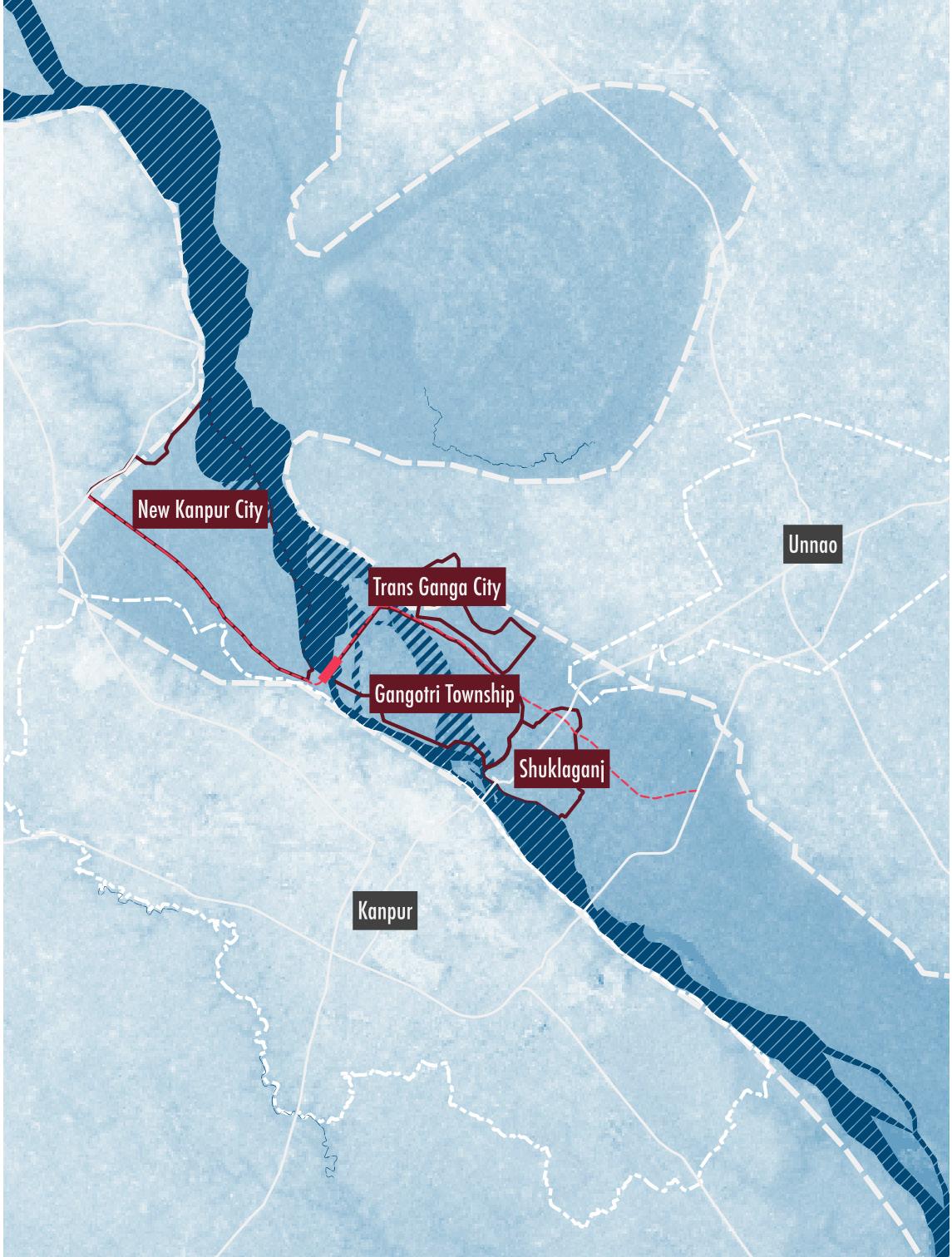
The barrage and canal construction would not only allow for the river to flow back into the ghats of Kanpur but also allowed the city to extract an additional 1600 million liters per day (MLD) of portable water from the river to expand it’s formal water supply network of the city. Additionally, a straighter river was seen as an opportunity to build extension areas into the newly reclaimed land within the floodplains of a previously meandering river, whose naturally curvy nature was claiming constantly different areas of lands throughout the years. For this, Kanpur City received additional funding from the national government to develop under the ‘Smart City’ scheme new high-tech development projects. Over an area of 6500 hectares, three such development projects are to be realized by 2030, known as satellite towns of ‘New Kanpur City’, ‘Gangorti Township’ and ‘Trans-Ganga (Hi-Tech) City’. Each of these satellite towns are meant to give a face lift to the congested inner city areas of the current city, creating more attractive development sites for international companies to open up head headquarter offices and attract new investment into the city by the tech branch. Yet, all these political motivations of development and attracting new investment has overshadowed the fact that each of these extension areas will be built into the geographical floodplains of the river that naturally expend 5-7 km wider to the east from the main river stream (see light blue hatch in diagrams of Fig. 23).
56 Ganges River in the Age of the Anthropocene
1998 2003 2005 2010
urban settlement encroachment into floodplains floodplains areas
57 Politics of Infrastructure
Fig. 23: Aerial image and diagram showing river course change of Ganges river along Kanpur City from 1998 till 2010.
By 2005, as the new barrage construction was completed and Kanpur City regained once again access to the holy river by it’s banks.
Yet, in 2010, one of the worst recorded floods with record high water levels were measured right downstream from the barrage (see Fig. 23 on previous page). Most likely, a straighter riverbed, rather than being constantly re-carved by a straighter river channel with higher river flow velocity, was in reality becoming shallower by collecting higher amounts of sedimentation as the natural floodplains on the opposite bankside of Kanpur City were constricted by new embankments built for a new four-lane highway. Upstream from the barrage, the barrage gates collected excessive amounts of sedimentation and also created a shallower riverbed (Khan et. al, 2018: 765) and contributed to an even stronger meandering of the river with more intensive floodings into smaller villages as barrage gates were kept raised to protect the Kanpur City during heavy rain events. Yet, a shallower river downstream could not hold so much rainwater runoff and swell beyond the embankments of Kanpur City anyways.
58 Ganges River in the Age of the Anthropocene
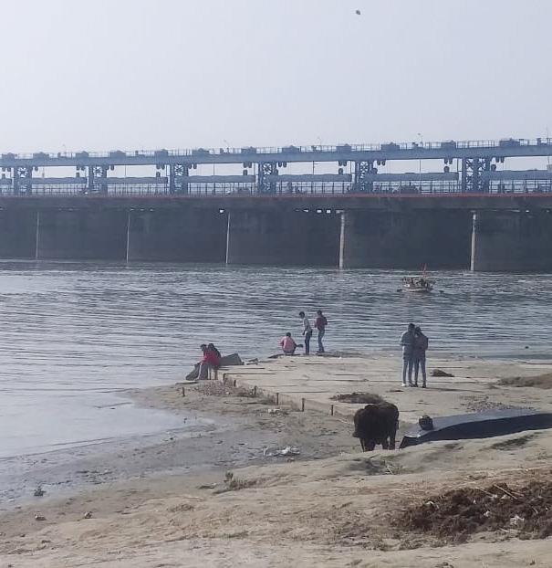
B
59 Politics of Infrastructure
View of LuvKush Barrage from Ganges River ghats in Kanpur City.
CHAPTER SUMMARY FOR POLITICS OF INFRASTRUCTURE
The case study of Kanpur City’s barrage construction presents a case of floodplains not only encroached and exploited by new development schemes possible through river infrastructure projects but also showcase how floodplains are no longer democratic spaces as river floods no longer remain solely a natural occurrence. Major cities’ planners have the capability to redirect floods into rural countryside, where population density is lower but agricultural productivity of the country suffer due to crop loss of long inundation periods.
Even as engineers and politicians have now gained the power of calibrating river levels and water flow through new logics of river infrastructure, they not only created a tool to manipulate the river flow to their advantage, but have also taken up the responsibility to decide which regions need to be flooded when momentary cloudburst create unexpected high levels of water in the river. It has become their responsibility to decide when to open the barrage gates as critical levels of water pressure build up against it. By creating an infrastructural intervention in the naturally meandering river, they not only created new logics by which to design artificial floodplains but also created a new network of interdependent villages relying on the decisions of major cities. These new trans-localities formed through river infrastructure and their operators along the river most often place rural communities and their land and properties secondary, making them bear out the consequences of the actions of major cities.
As the title of the thesis calls out ‘Ganges River in the Anthropocene’, it is these infrastructural projects that define new logics of engineered landscapes that make up anthropogenic interventions by humans on the natural floodplains of rivers. Engineered landscapes not only alter the natural logics of water flow and convert natural floodplains into designed flood zones but also hard-line and separate land-uses of previous transient zones constantly negotiated between land and water, eliminating a wide range of habitats for humans and non-humans who called these zones their home.
60 Ganges River in the Age of the Anthropocene
61 Politics of Infrastructure
Fig. 24: DEM model of Kanpur City region, representative water map indicating lowest elevation of the region in darker hues of blue.
62 Ganges River in the Age of the Anthropocene
Small passenger boats taking tourists and locals on small trips through the holy waters of the Ganges River by Kanpur City.
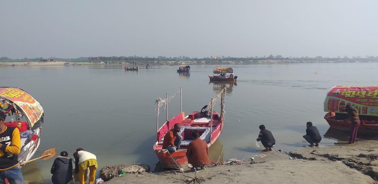
Locals enjoying the open view of the Ganges River in Kanpur City.
C
D
View of Ganges River and from ghats in Kanpur City over to floodplains on opposite site by Gangotri Township.
E
63
POLITICS OF LAND
Floodplain governance structure & settlement typologies
 Brijghat (rural)
New Delhi (urban)
Jamunariver Gangesriver
Kanpur City (in rapid transformation)
Brijghat (rural)
New Delhi (urban)
Jamunariver Gangesriver
Kanpur City (in rapid transformation)
64 Ganges River in the Age of the Anthropocene
Fig. 25: Diagram showing location of three floodplain settlement settings within the GRB.
The chapter ‘Politics of Land’ explores narratives of land-use along two sites of the Ganges River and one site along the Jamuna River (see Fig. 25). Documenting communities and urban development projects that make up an array of land-use conflicts, the chapter analyzes a rural river setting in Brijghat, an urban river setting within New Delhi and lastly Kanpur City’s floodplains which are in a state of rapid transformation from rural to urban. Through the study of these three floodplain sites, the chapter concludes with a proposal of how to begin to index floodplain encroachment that could assist with planning floodplain zoning strategies in the future. By indexing encroachment into varying typologies, the hope is to create a more nuanced understanding that not all human encroachment into floodplain is necessary bad, but on the contrary, controlled and planned activities into floodplains could lead to positive synergies between human habitats and river ecologies in the future.
65
CURRENT STATE OF FLOODPLAIN PLANNING IN INDIA
If the previous chapter highlights how river infrastructure encourages floodplain encroachment by creating a false sense of protection from the river to nearby residents, how much has the Indian government recognized this as a problem, and how is it dealing with encroachment currently?
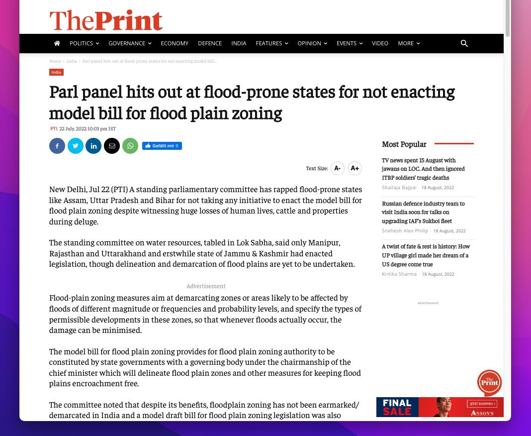
Currently in India, the central government recognizes there is a need for floodplain zoning in order to protect lives and property of their citizens. In February 2009, the Indian government set up the ‘National Ganga River Basin Authority’ (NGRBA) and in 2011 they also set up an ‘implementation arm’ known as the ‘National Mission for Clean Ganga’ (NMCG), within the central governance branch of ‘Ministry of Jal Shakti’ (Department of Water Resources, River Development & Ganga Rejuvenation). With a river basin wide river management authority, the goal was to provide a centrally planned action plan through which the state governments could apply funding schemes to clean up the Ganges River. Since than, in 2016 the NGRBA was converted into the ‘National Counsil for River Ganga’ (NCRG) (NMCG, n.d.) with the main goal stated as:
“The Act envisages five tier structure at national, state and district level to take measures for prevention, control and abatement of environmental pollution in river Ganga and to ensure continuous adequate flow of water so as to rejuvenate the river Ganga.” (NMCG, n.d.)
But even as many ministries and funding missions exist, so far, very little has been implemented in terms of planning policies. Only two official policy mandates dealing with floodplain zoning exist till date in India, both of which have been issued by the central government to all states. The first ‘Model Bill for Flood Plain Zoning (MBFPZ)’ was issued in 1975 followed by a more concrete and thorough ‘National Disaster Management Guidelines for flood’(NDMG) issued in 2008 (Modak and Kapuria, 2020: 8). Yet, as land zoning falls under the jurisdiction of each individual state in India, the two policy documents issued by the central (union) government branch can only act as a prescriptive guideline as zoning floodplains also fall under the jurisdiction of each state. The documents list each states task is to survey and delineate flood hazard zones, set up a new governance branch acting as a floodplain management authority with rights to act by communicating action plans to the communities and removing illegal encroachment into floodplain zones (Modak and Kapuria, 2020). By letting each state create
66 Ganges River in the Age of the Anthropocene
their own set of floodplain zoning strategies, each state has the opportunity to zone their floodplains based on unique riverine conditions, gaging it towards the communities that inhabit them and incorporate unique conditions and requirements by location along the river.
A generally very positive outlook on floodplain zoning by the central government has rather back fired. As shown on the article in Fig. 26, from 22 July, 2022, most states have not yet implemented any concrete actions towards floodplain zoning, but rather as the following case studies in New Delhi and Kanpur will showcase, corruption in lower tears of the legal government branches have exploited the past 75 years of ambiguity in land-use and ownership rights within floodplains to their own advantage, while the poorer communities that have inhabited the lands since decades are left without rights and displaced without new homes. (The Print, 2022).
[advertisement]
67
Fig. 26: Online news article showing the frustration of the central government as ‘flood prone states’ have failed to implement a floodplain zoning bill nearly 47 years after the first initiation back in 1975.
Politics of Land
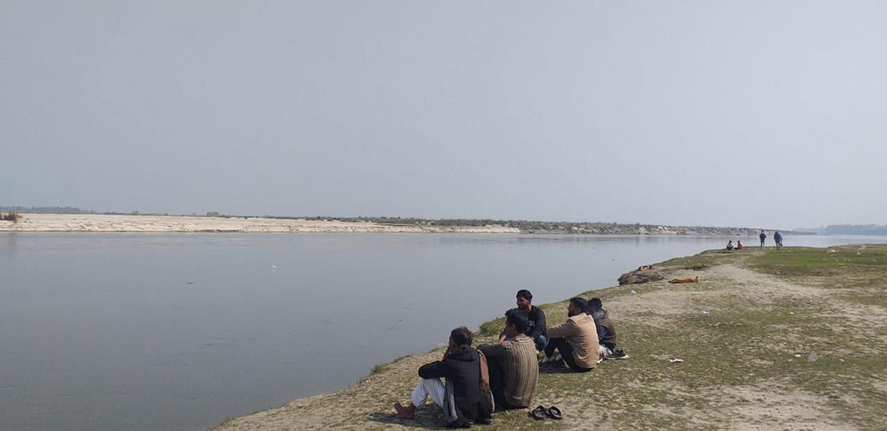
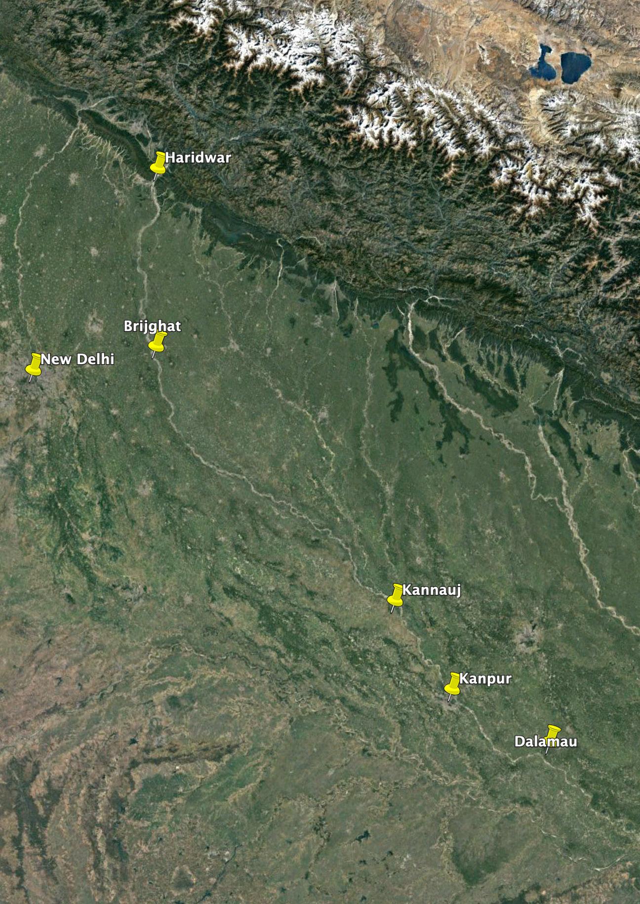
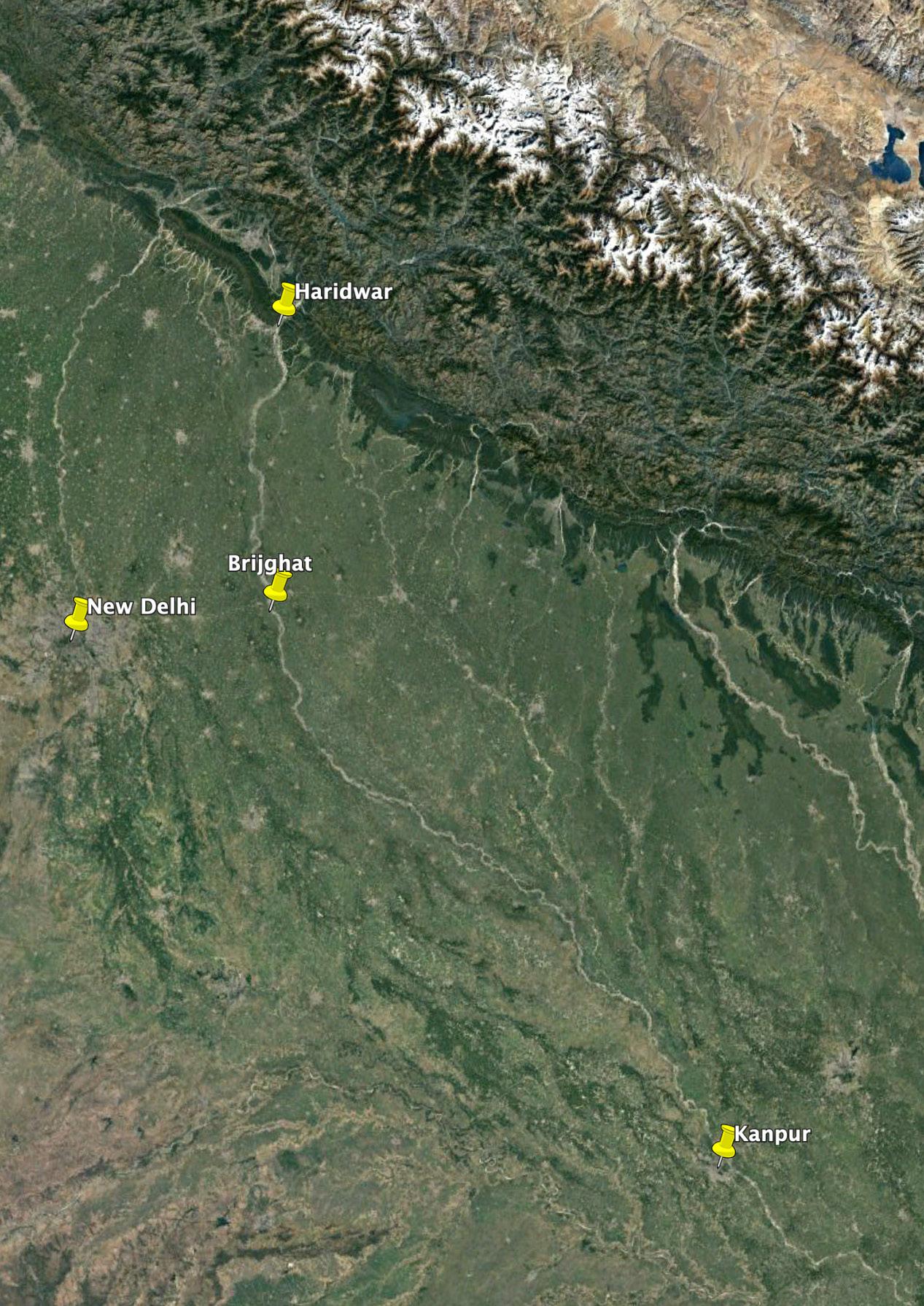
If urban flood conditions are well documented within news outlets and scientific papers, it is the rural conditions that are often forgotten. To better understand the various landscapes and activities that make up unique spatial settings along the river, I went and studied one of these rural setting for myself during a trip back home to India in February 2022. Visiting the closest locations of the Ganges River from my home town New Delhi. It was a two-hour drive to cover about 100km from Delhi to Brijghat. I had very little prior knowledge of the site besides that it was an important location for cremation ceremonies. I thought I would find a mighty river, either polluted like I had known it from Delhi, or still pristine clean as I knew it from the Himalayas where our school took us on week long school trips in the autumn months. Yet, when I first arrived there, what I saw was beyond any previous encounter I had with a river.
68 Ganges River in the Age of the Anthropocene
69 Politics of Land
Fig. 27 Satellite image showing the landscape along the rivers within the GRB.
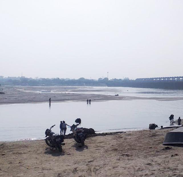
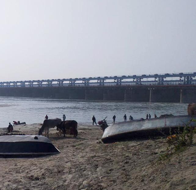
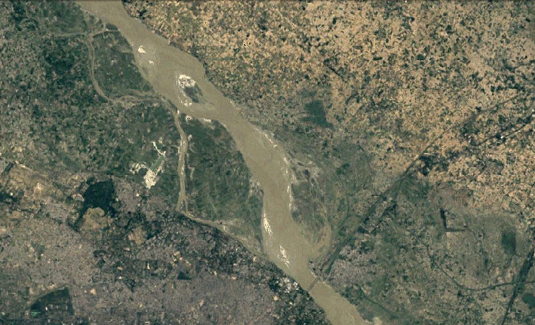
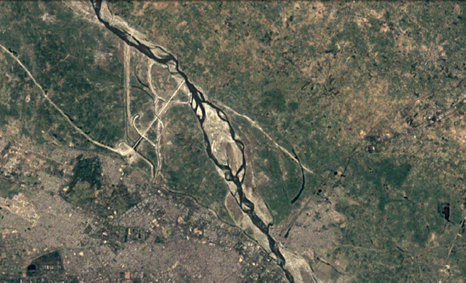
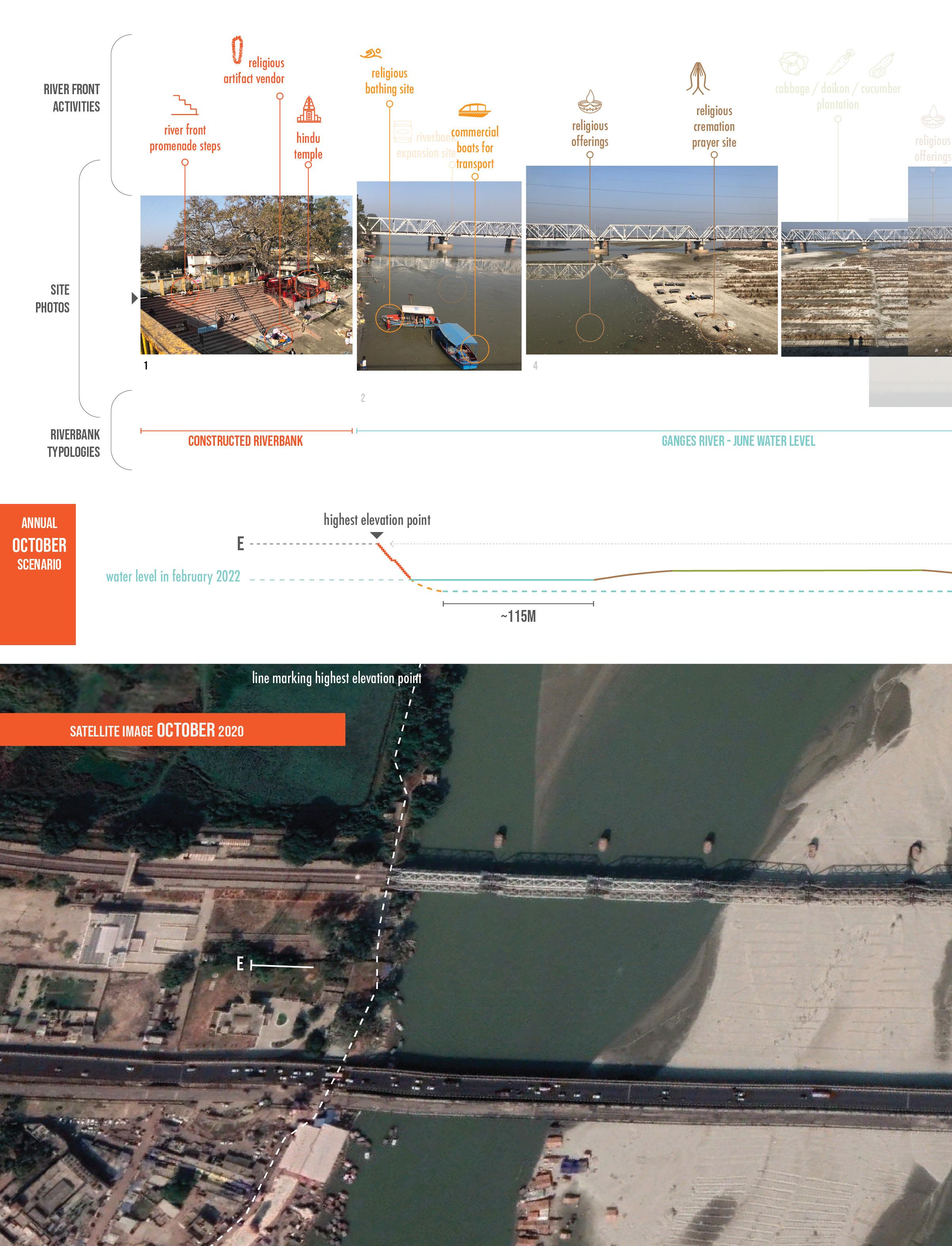
SITE OBSERVATIONS AT BRIJGHAT (RURAL RIVER REGION): TRACING TRADITIONAL KNOWLEDGE OF CO-LIVING WITH THE NATURAL WATER CYCLE
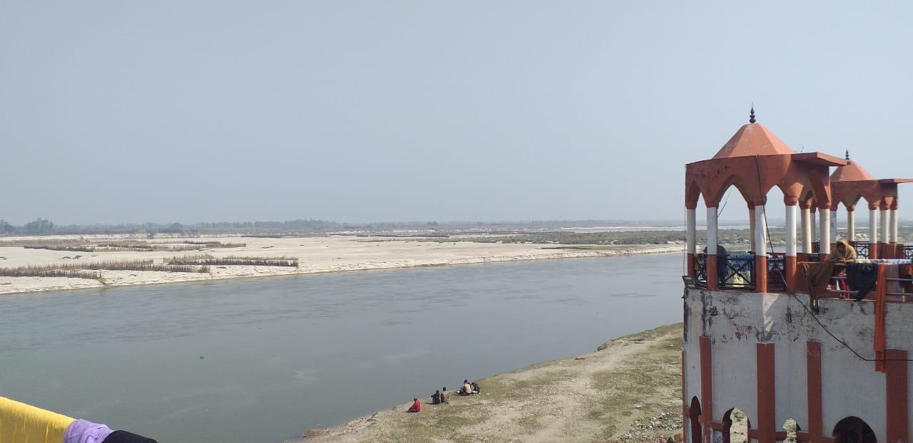
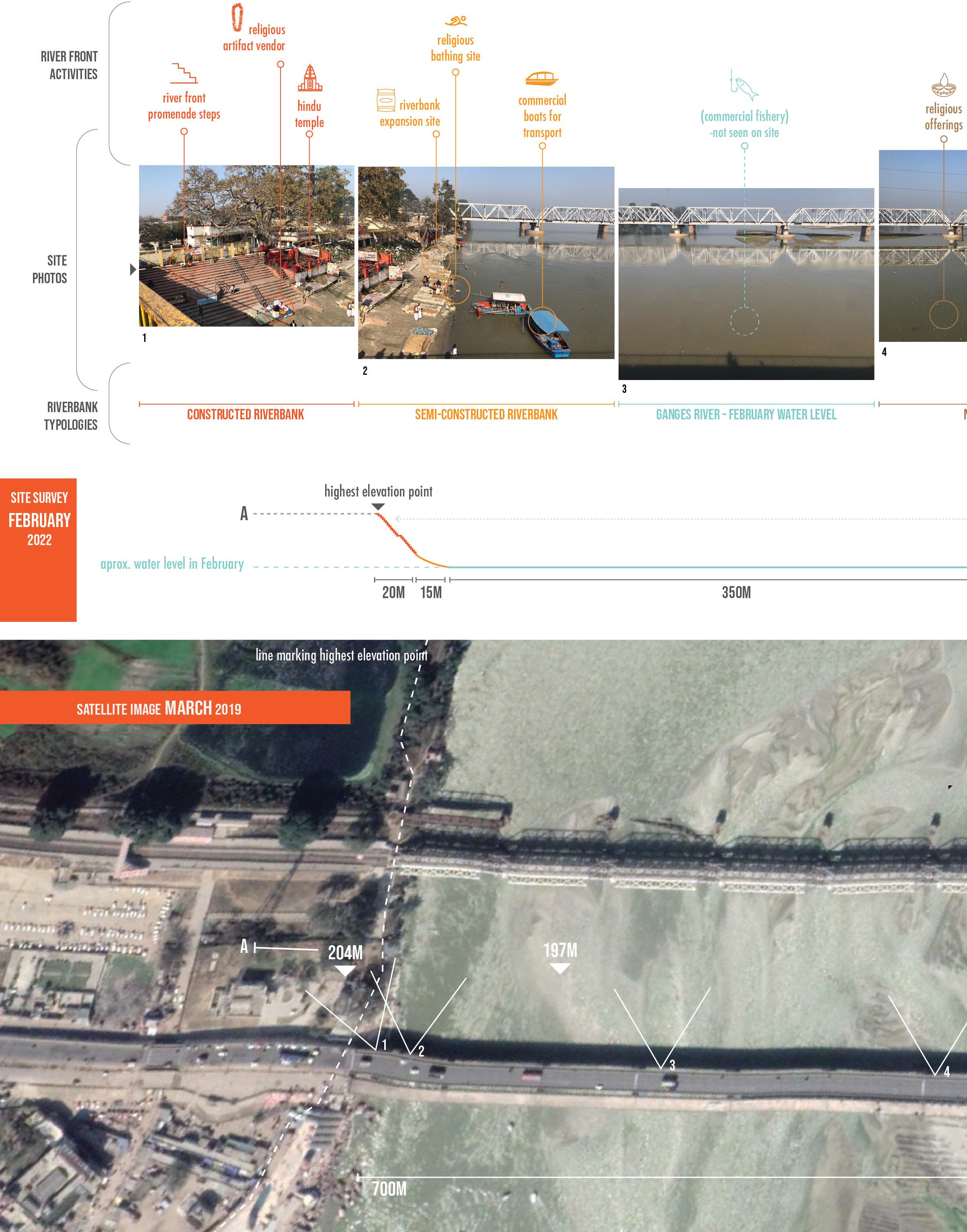
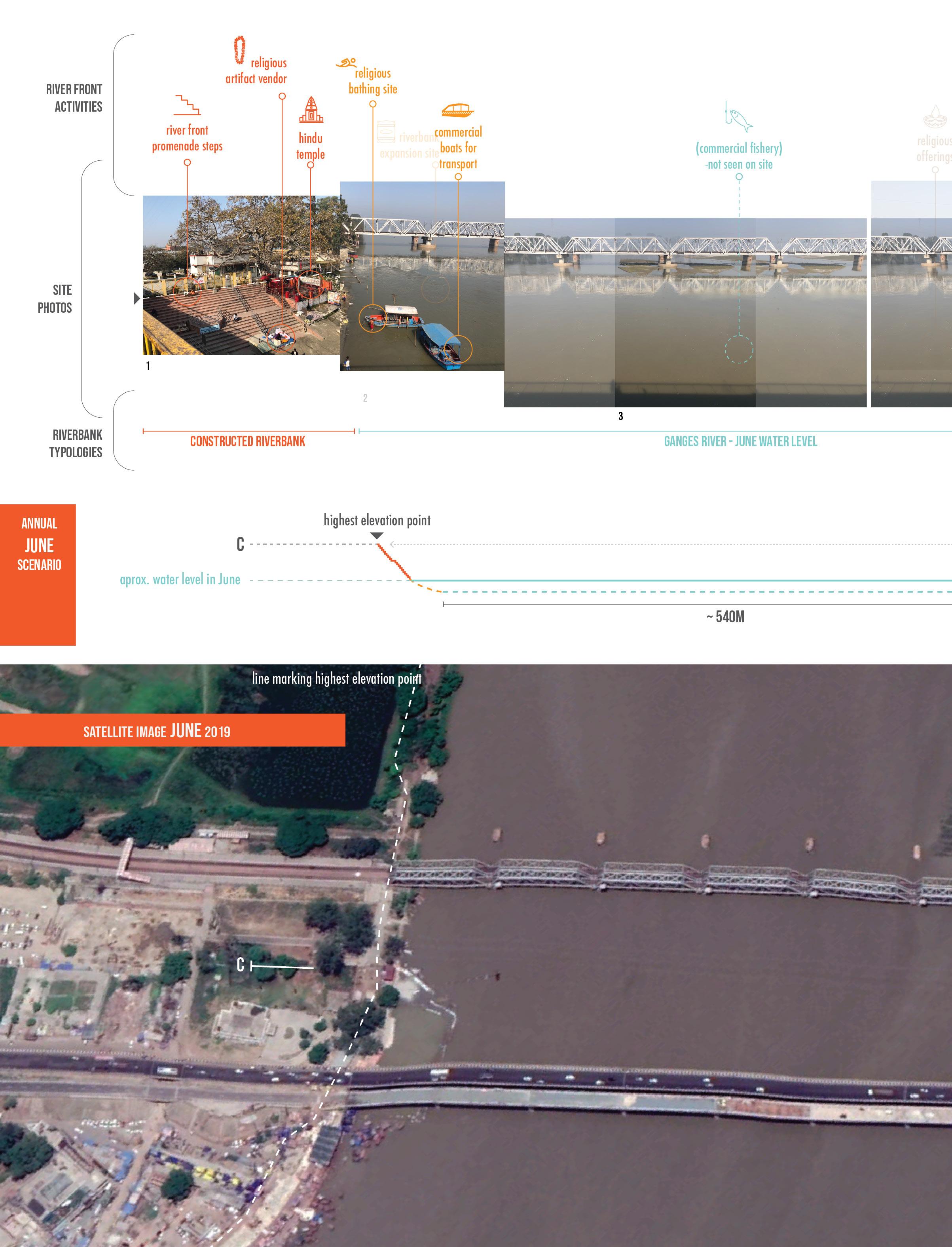
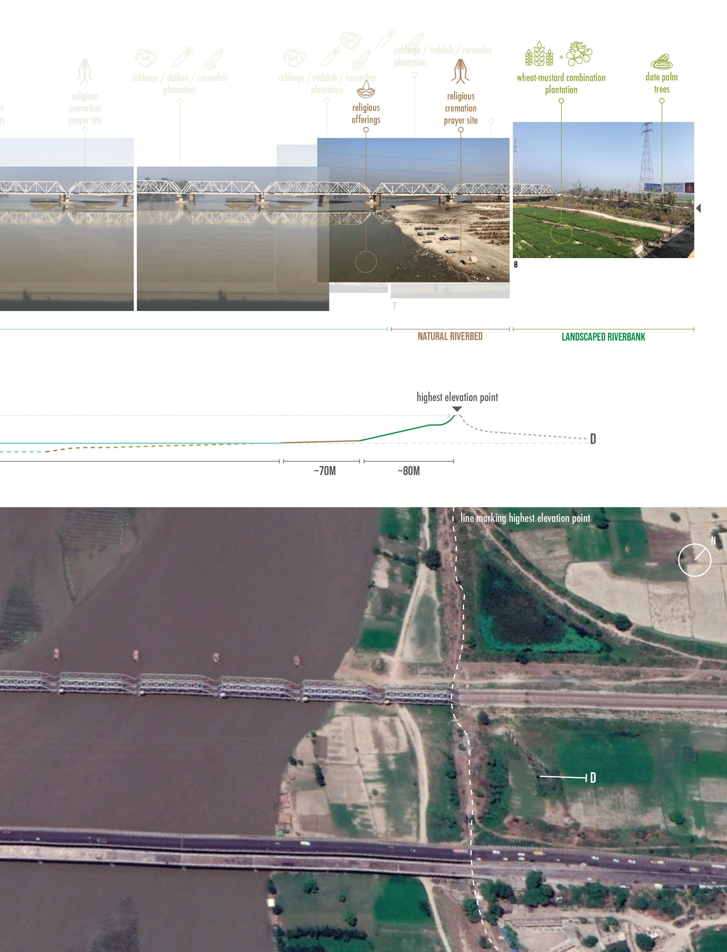
Brijghat is a small rural settlement with two main economic activities. Along a very wide river channel the two opposite riverbank sides with each a distinct economic activity is quite a site to behold:
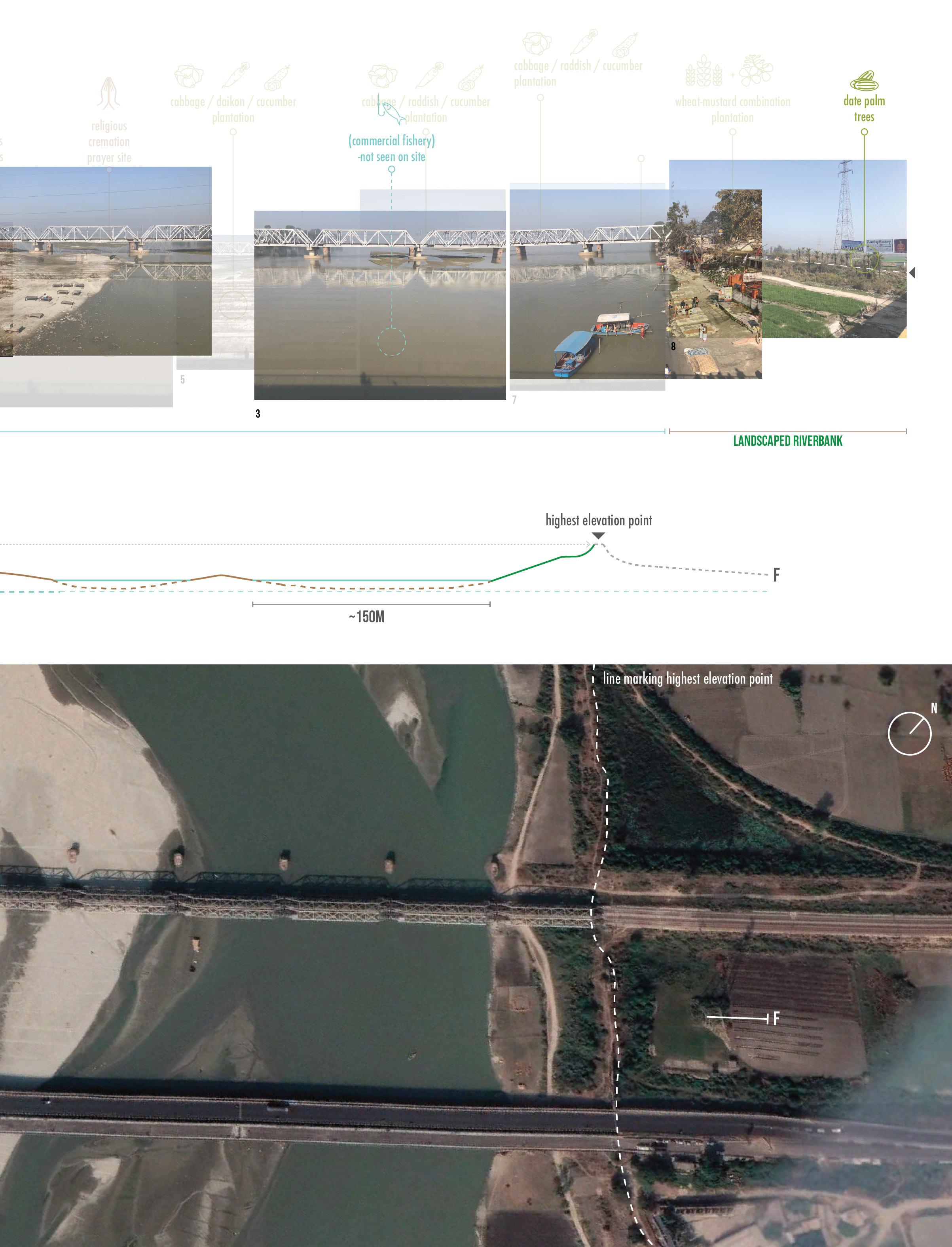
On the one side of the riverbank (referenced in site photos as bankside A), facing upstream there is a semi permanent promenade structure made out of sandbags that allow devotees to a dip in the river water (A-1) while facing downstream there is a small community along a paved river promenade where vendors sell religious artifact and street food to accompany a traditional cremation ceremony that takes place a bit further down the paved promenade in a more private setting (see Fig. 28). On the other side of the riverbank (bankside B), there is a vast landscape hosting agricultural activities that spans both upstream and downstream (see Fig. 29) within the riverbed. Yet, on the upstream side, there seems to be a man-made levee system that separates the main river channel from irrigated agricultural land beyond it (B-1).
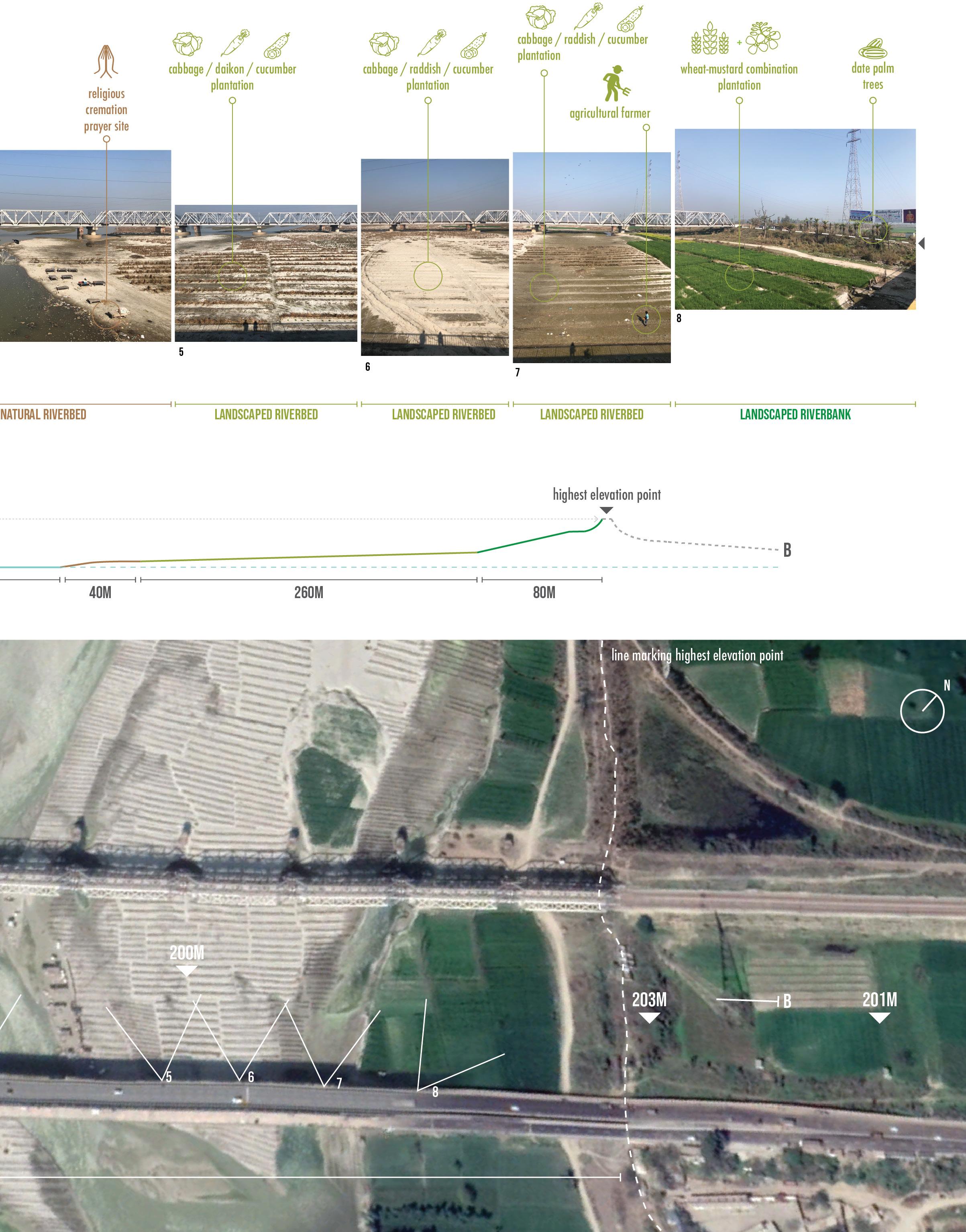
The riverbed from bankside A to bankside B spanned over 700 meters wide, while only half of the it contained slowly flowing river water. On the other half along the exposed dryer riverbed, there are neatly organized rows of high grass that created clear rows for farming between. The high grass protects plant saplings in their early stage from high winds and long hours of sun exposure along these wide open stretches of riverbed plains. A local farmer on the riverbed explained to me that he was currently harvesting cucumber and cabbage on the exposed river bed. When asked, who the land belonged to, the farmer told me that the land belonged to the government but could be leased per harvest season.
All these impressions, photos and informal interviews are drawn up into a panoramic photo collage, along with a riverbed section and annotations with activities that took place by the river in the month of February (2022). As February is a dry season for the river in this region, the impressive site of a partially exposed riverbed is quite common this time of year (see Fig. 30, on next page).
70 Ganges River in the Age of the Anthropocene
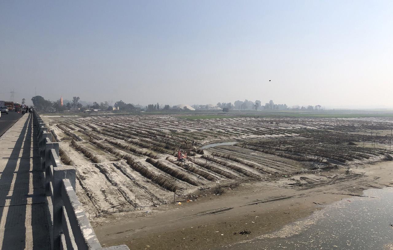
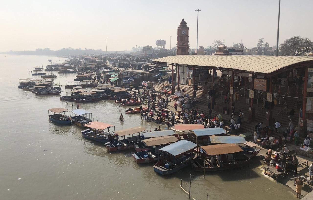 Fig. 29: Bankside B-2: agricultural activities in the month of Febuary.
71 Politics of Land
Fig. 28: Bankside A-2: Community of vendors selling religious artifacts, street food and boating trips along the holy Ganges River.
72
Ganges River in the Age of the Anthropocene
73 Politics of Land
Fig. 30: Panoramic photo collage, section and satellite image showing site analysis of Brijghat in February, 2022.
The the main water channel is dividend into five distinct land-use sections consisting of:

Constructed riverbank, with mostly sealed surfaces like a paved promenade or staircase,
Semi-constructed riverbank, build with sand bags as temporary structures,
Natural riverbed, that is seasonal and emerges in new shapes after each monsoon period, here temporary ceremonial structures are placed
Landscaped riverbed, where mostly agricultural activities take place on seasonally exposed natural riverbeds (see Fig. 31)
Landscaped riverbank, a constructed levee that separates the main floodway from the flood fringe beyond, here mostly seasonal and perennial agricultural activities take place where also for example here date trees are planted (see Fig. 32)
Through further exploration of the landscape with the use of digital elevation model (DEM) the levee built on the bank side B was a meter lower at its highest point, measuring 203 meters while the highest side on the opposite bank side A measured at 204 meters (Kanpur topographic map, elevation, relief, n.d.). This systematic levee construction as seen on Fig. 32, shows a designed levee that separate rain-fed riverbed farming from irrigated farming beyond. When closely observed, these irrigated farming lands have a small white built structure that had the government irrigation scheme seal painted on one side, indicating that state built water wells existed in the irrigated farming landscape.
To better understand what the landscapes and activities during wet season in July and right after monsoon (wet season) in October would look like, I repeated the same analysis. But as a repeated site visit was not possible during different months of the year, I used satellite images from Google Earth’s timeline function from the previous years and reorganized the panoramic photo-collage to match the satellite image from June 2019 (Fig. 33, on page 76-77) and October 2020 (Fig. 34, on page 78-79).
74 Ganges River in the Age of the Anthropocene
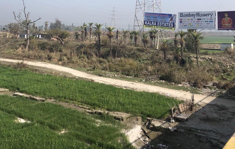
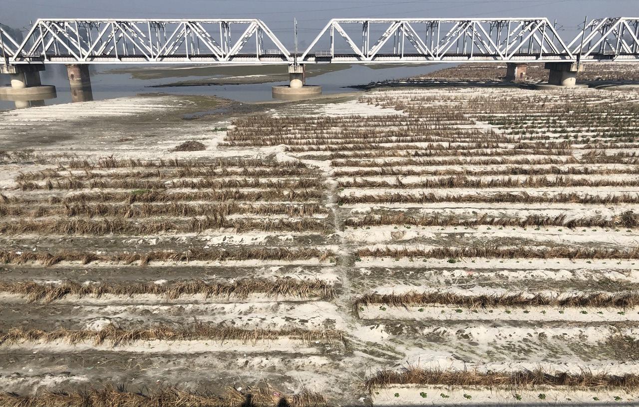 Fig. 32: Bankside B-1 showing rapeseed harvest within the riverbed, with a raised levee construction separating the infrared farming from irrigated farming beyond the levee structure.
75 Politics of Land
Fig. 31: Bankside B-1 showing rain-fed farming with daikon, cucmber and cabbage crops inside the riverbed.
76
Ganges River in the Age of the Anthropocene
77 Politics of Land
Fig. 33: Panoramic photo collage, section and satellite image showing analysis of Brijghat as expected in the month of June.
78
Ganges River in the Age of the Anthropocene
79 Politics of Land
Fig. 34: Panoramic photo collage, section and satellite image showing analysis of Brijghat as expected in the month of October.
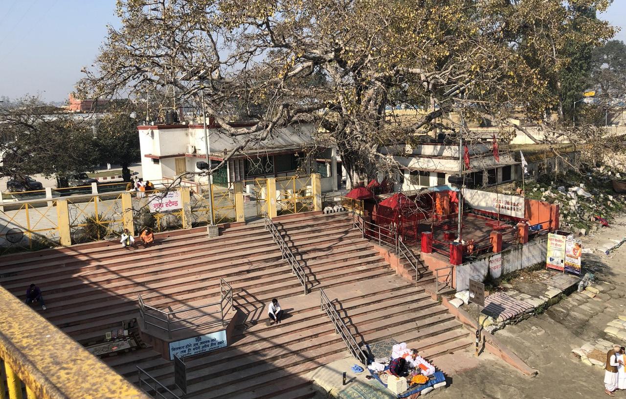
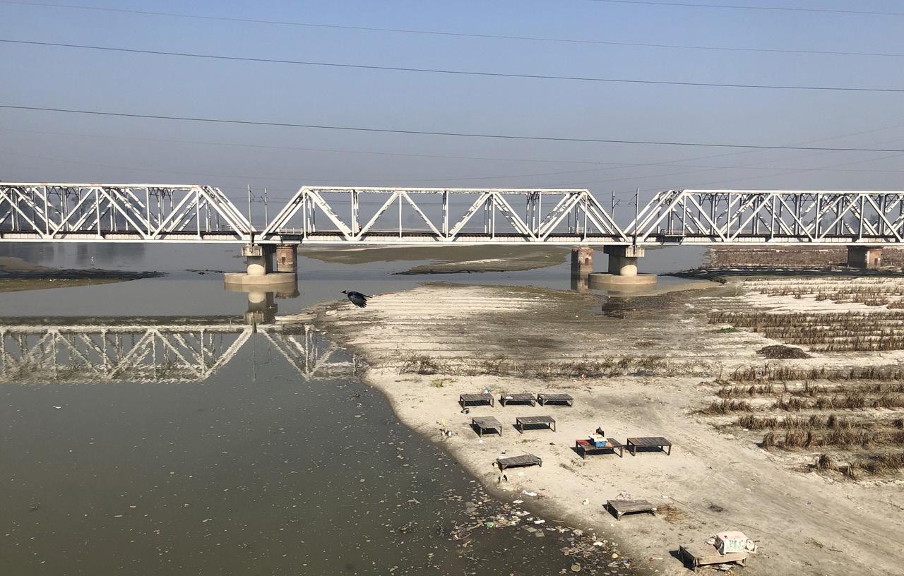 Fig. 36: Bankside B-1 showing exposed riverbed with both hood structures for religious ceremonies and agricultural activities.
80 Ganges River in the Age of the Anthropocene
Fig. 35: Bankside A-1 constructed promenade stairs leading down to riverbank.
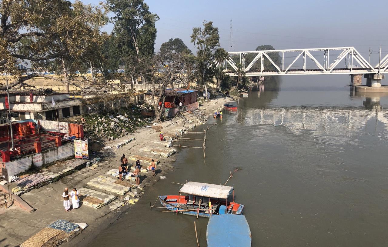
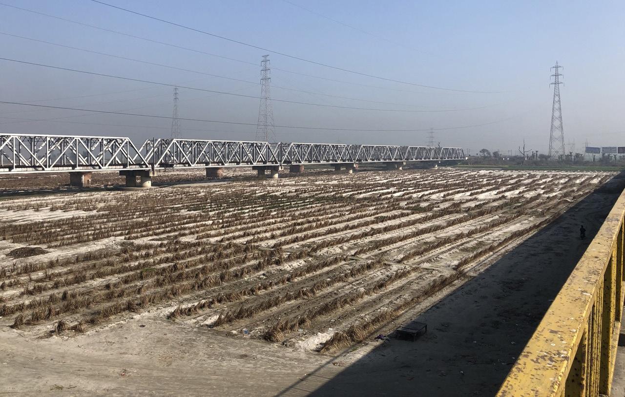 Fig. 38: Bankside B-1 showing agricultural activities in the month of February.
81 Politics of Land
Fig. 37: Bankside A-1 sandbags at riverbank to secure sand from being washed out by river current, along with Hindu priests and devotees taking a bath.
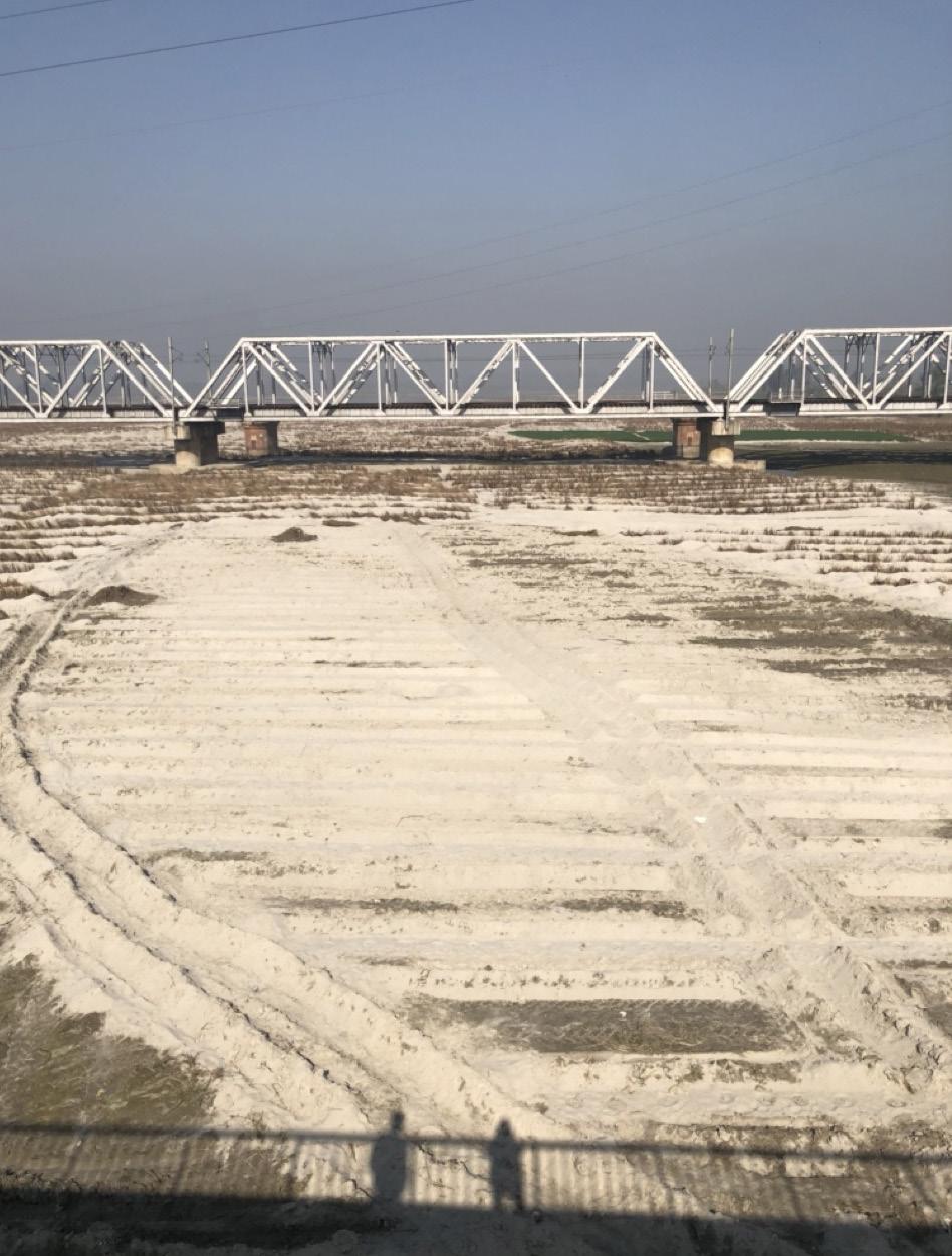
82
River in the Age of
Fig. 39: Bankside B-1 showing agricultural activities in the month of February.
Ganges
the Anthropocene
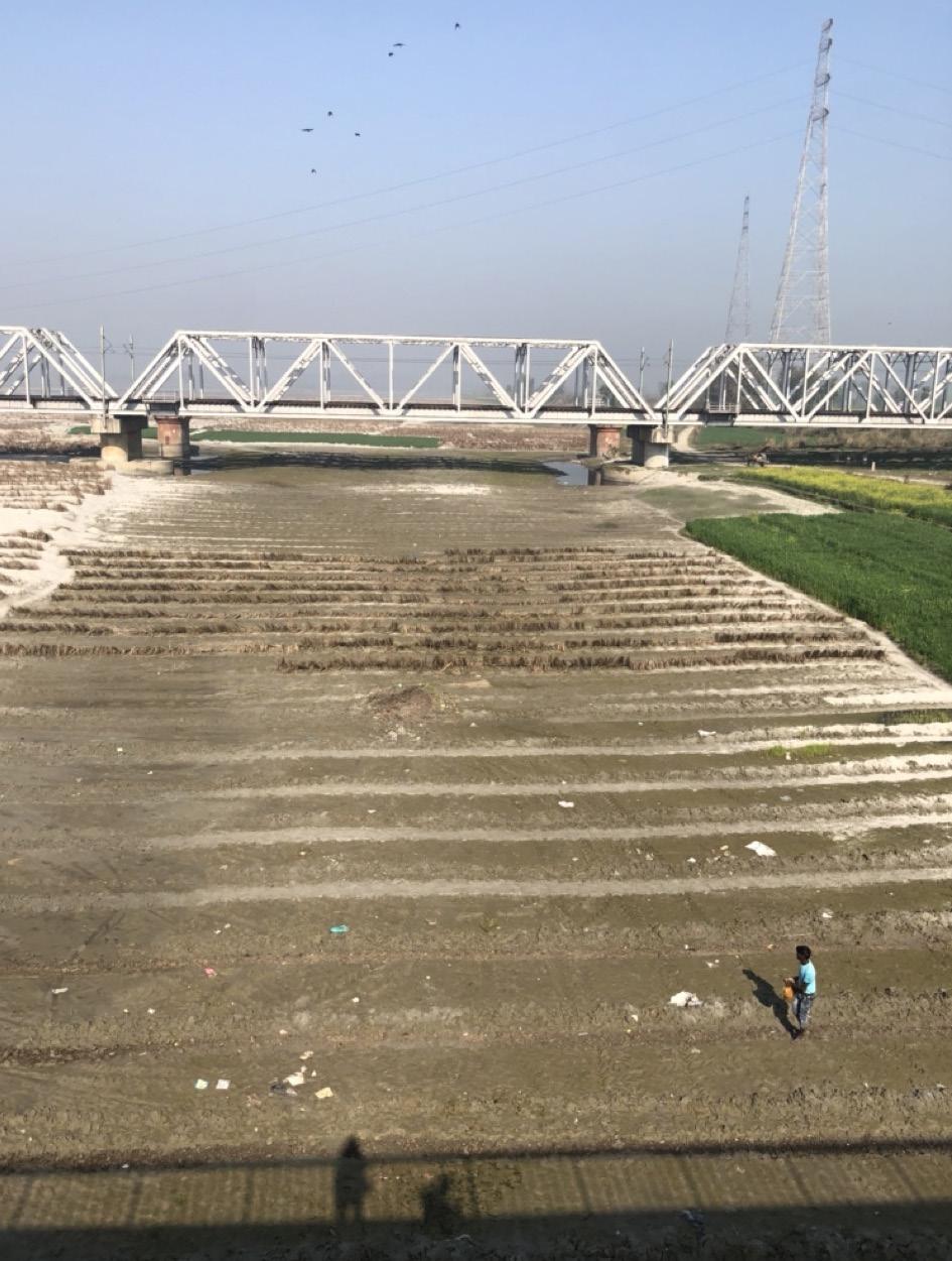
83 Politics of Land
Fig. 40: Bankside B-1 showing floodplain farmer spreading seeds over riverbed.
Before going on my site visit, I had briefly glanced at a satellite image to get an initial understanding of what the site might look like (see Fig. 42). Yet, after returning back home and going through the exercise of documenting the site images and drawing up sections, I quickly realized just how much I had under-estimated the reach of the floodplains by only documenting the 700 meter wide section of the floodway, while misjudging the actual scale of the flood fringe region and thereby also missed an opportunity to document a wider section of the landscape.
National Geographic define floodplains as:
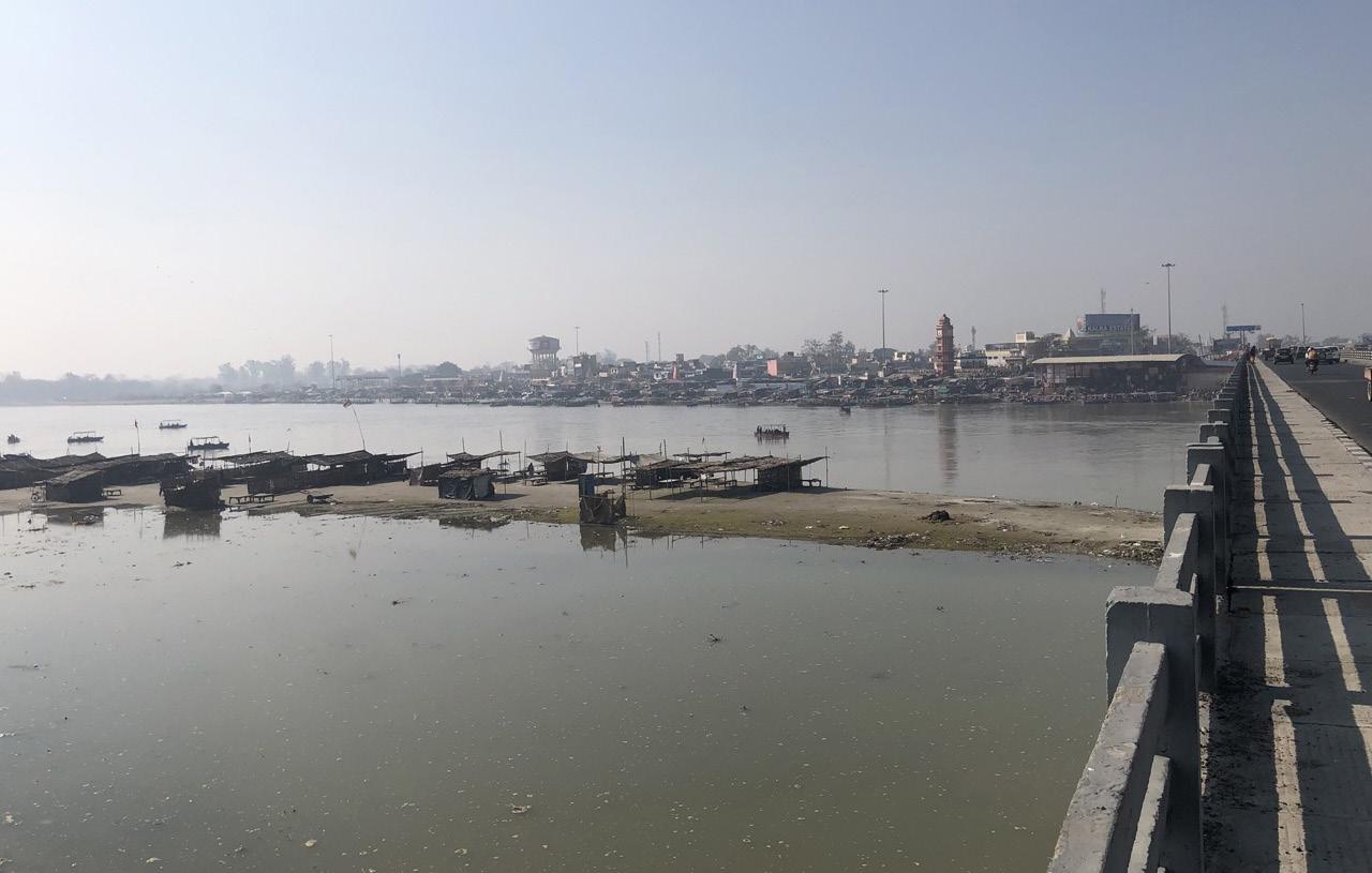
“a generally flat area of land next to a river or stream. It stretches from the banks of the river to the outer edges of the valley. A floodplain consists of two parts. The first is the main channel of the river itself, called the floodway. Floodways can sometimes be seasonal, meaning the channel is dry for part of the year. ... Beyond the floodway is the flood fringe. The flood fringe extends from the outer banks of the floodway to the bluff lines of a river valley. Bluff lines, also called valley walls, mark the area where the valley floor begins to rise into bluffs.” (Evers, 2022)
With this definition of the flood fringe, I understood there was a wider valley of the river that extended beyond the 700 meter wide floodway (riverbed) I had recorded. On a digital elevation model of Brijghat (Fig. 44, on next page) I was able to quite quickly identify the flood fringe areas which made up the flattest part of the valley with approximately 5 meter elevation change over any given width along the river path, being almost 15 kilometers wide.
84 Ganges River in the Age of the Anthropocene
Fig. 41: Bankside A-2 showing small tents set up for ceremonial rituals and promenade community beyond.
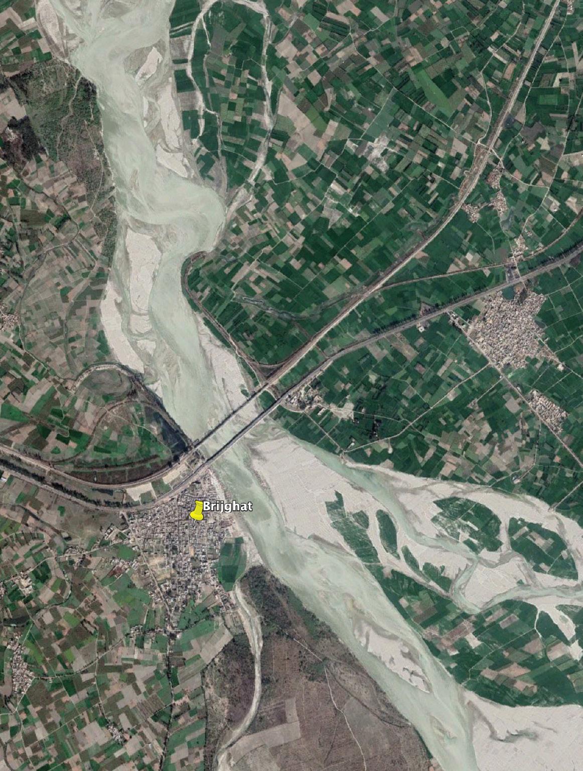
85 Politics of Land
Fig. 42: Aerial image from November, 2018 showing Brijghat and Ganges River.
700M
All in all, the site visit was crucial in understanding that a simple law of zoning floodplains and pushing out all encroachment inside the active flood zones is not necessary. This specific region and it’s communities had a very strong bond to the river and knew how to live with annual water level fluctuations. They had a deep understanding of the river, the local weather patterns and how to farm sustainably in riverbeds without jeopardizing soil health or creating additional water stress for the region.
Known as the khaddar farming system, where khaddar in Hindi refers to fertile soil in floodplains along rivers (Pradhan, 2020). Farmers refer to soils in these plains by two terms, khadir when the soil in the area is below flood levels and bangar when the soil is above the flood levels where more lime nodules are found within the soil. These terms alone show the ancient old knowledge farmers of these lands had about soil composition and fertility as well as flood seasons and water levels. Their trade of floodplain farming is ancient and deeply embedded into local knowledge about soil, land and water. Their lifestyle is transient as they are used to reorganizing among themselves the areas of the riverbed that would reappear in new shapes each time after monsoon, as sediments would settle differently based on water currents of the river. These farming systems also termed todays two main harvest cycles of kharif and rabi crops in India which are timed with the arrival of monsoon winds and incoming rains each year.
But if not these rural communities, than which communities make up the high number of 45 million people who are annually affected by floods in India?
86 Ganges River in the Age of the Anthropocene
Fig. 43: Bankside B-2 showing a monkey family hanging out and begging for food along the main highway over the river.
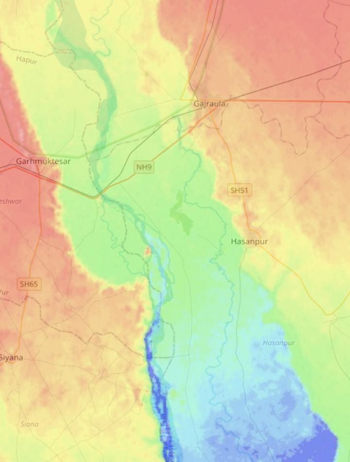
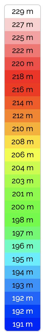
42 5km 15km 700m
Fig.
Fig. 44: Open access (online) Digital Elevation Model (DEM) showing Brijghat with annotations of self delineated floodway and flood fringe. (Kanpur topographic map, elevation, relief, no date)
87 Politics of Land
flood fringe floodway
CORRUPT KHADDAR FARMING SYSTEM IN NEW DELHI (URBAN RIVER REGION)
Currently, such floodplain farming (khaddar farming) communities work within cooperatives and mostly work on leased land of the state, making them in the long term vulnerable to evictions and land grabbing for new development schemes by both the private and public sectors. One such case of vulnerable communities are the khaddar farming communities of the Jamuna River in Delhi who were being exploited from within their own farmer’s cooperative in New Delhi. (Chetan and Pradhan, 2018)
The floodplain lands in Delhi known as the royal lands were confiscated by the British back in the 1860 from the Mughal Emperor and noble men (nawabs) who used these fertile landscapes for their private gardens or hunting grounds. Stretching 14 km along the Jamuna River through New Delhi (see Fig. 45), these lands were handed over in 1937 to the newly founded Delhi Improvement Trust (DIT) to be planned and developed. After India’s Independence in 1947, these lands, totaling close to 2233 hectares, were divided into four main revenue estates for collective farming and grazing for nearby villages and refugee camps hosting displaced people from the India-Pakistan partition. As India was already facing a food shortage these lands were meant to provide the extreme poor a place to live while pursuing farming to feed themselves. “DIT, called the Delhi Development Authority (DDA) from 1957, leased out large tracts of land [...] under the aegis of the Delhi Peasants Cooperative Multipurpose Society (DPCMS). DPCS allotted plots for farming to its members upon the closure of every monsoon, for flooding would often change the tangible shape of the khaddar: arable land in one season would be submerged in the next, and so orality and custom, rather than written law, had a dominant role in determining the scope and scale of land use upon the khaddar (Singh)”(Pradhan, 2020: 7-8) Meaning that often times, old customs of agreeing by a handshake made members of the DPCM agree on their alloted land and they would pay their rent without any written documents of such. (Chetan and Pradhan, 2018)
The peasants cooperative was meant to be a representative body of the floodplain farmers community, as few influential individuals from their village community were put in charge of the cooperative. This model of self-governance structure gave the community heads both the right to allot plots to it’s members but also collect ground rent on behalf of the DDA. The DDA periodically renewed a leasing contract to the DPCS between 1949 till 14 May 1966, after which they officially terminated their lease and told the DPCS to inform their members
88 Ganges River in the Age of the Anthropocene
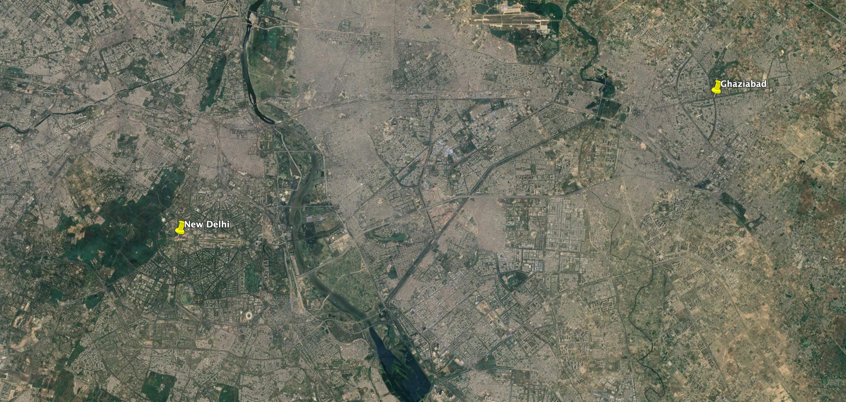
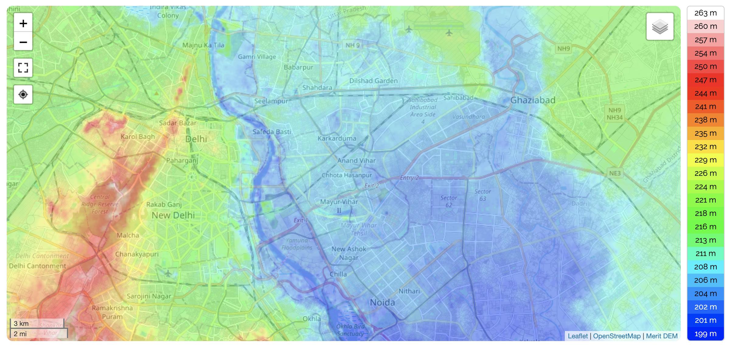 flood fringe floodway
Fig. 46: Digital Elevation Model (DEM) of New Delhi, marking the floodway and the flood fringe of the Jamuna River.
flood fringe floodway
Fig. 46: Digital Elevation Model (DEM) of New Delhi, marking the floodway and the flood fringe of the Jamuna River.
89
Fig. 45: Aerial image of Jamuna river in New Delhi with the floodplain farms (khaddar farming system) marked as ‘KFS.’ 3km 18km
flood fringe floodway
KFS
KFS
Politics of Land
KFS
that they will need to also terminate their activities. Not only did the DPCS not inform the farmers of these decisions by the DDA, also also they continued to collect ground rent for the next 28 years till 1994, and payed out revenues to DDA, who kept accepting these payments even after legal termination status was issued. (Pradhan, 2020)
Trusting the peasant cooperative heads, the farmers never questioned their rights to the land or the legality of their activities. Seen as easy vote banks by lower level political leaders, they were even issued Identification Cards, based on their addresses within the floodplains. Additionally, as affordable housing was in huge shortage, private agents even developed unauthorized settlements in these floodplains which underwent various stages of legalization “receiving political and cultural sanctions under populist waves of electoral promises in exchange for votes such as water and electricity connections even though legally they remained unauthorized”.
Yet, by 2004 residents awoke one morning the bulldozers who were authorized by the DDA to clear any crops or permanent structures on the estate grounds to make way for new development to be built for the 2010 common wealth games to be hosted in Delhi. But even after the games ended, in 2011, the one estate spared during previous wave of demolition was woken up with unannounced bulldozers as the DDA had new plans to convert the whole stretch of 14 km along the river into high-end river front promenade development under the pretense of city beautification projects.
This case study shows the highly vulnerable state not only these floodplain communities are if no legal grounding for their activities or long term land zoning exists, but also how vulnerable floodplains remain to large scale development projects that are driven by individual political leaders agenda and economic interest of more power entities over single farmer communities. Without floodplain zoning and proper demarcation of land-use and legal activities, unwanted urban encroachment will always have the upper hand while both low impact encroachment communities and river ecology continue to suffer (see Fig. 47 for a possible scenario of floodplain farmland transforming into informal urban settlements).
90 Ganges River in the Age of the Anthropocene
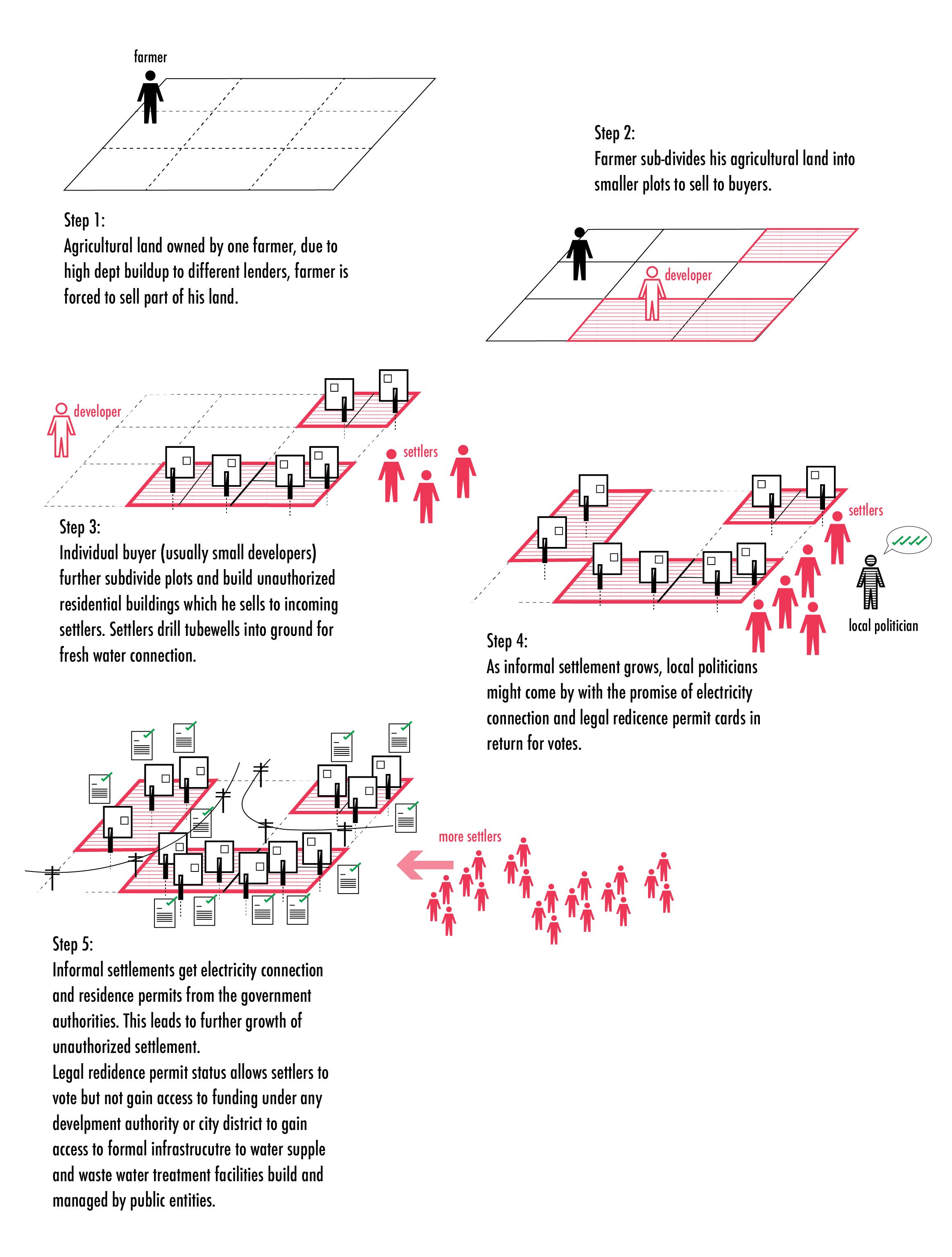
91 Politics of Land
Fig. 47: Diagram showing process of informal settlement growth and legalization processes over time.
FOUR FLOODPLAIN COMMUNITIES OF KANPUR CITY (RIVER REGION IN TRANSFORMATION)
Similar to Delhi’s legally contested floodplain cites, Kanpur City’s floodplain development is moving in the same highly dense settlement encroachment trend as the city is growing in population and popularity. Projected to become one of the countries ‘100 smart cities’ its population grew from 2.8 million inhabitants in 2011 to 3.2 million in 2022. Projecting promises of high-tech and ‘smart urban’ extension areas, it is building an attractive narrative for its future investors from the IT world that would have the ability to bring their headquarters to three newly designed eco-conscious satellite township developments by the riverfront of the Ganges River, which at a closer look reveal that all three of the satellite towns are planned within the flood fringe zones of the river as shown in Fig. 48:
New Kanpur City, upstream from the barrage (4000 hectares)
Gangotri Township, downstream from the barrage (2000 hectares)
Trans Ganga Hi-tech City, downstream from the barrage (463 hectares)
Kanpur City has the attention of all those living downstream of the river as it tries to shed off its long holding title as the biggest polluter of the Ganges River (Mariya et al., 2019). Hosting the biggest leather and tannery industry of India along with various other highly water polluting industries it is trying hard to attract cleaner economic models that could build new reputation for the future. But it is not alone in this endeavor as it gets support from government branches on state and nation level through the two schemes of ‘Smart City Mission’ that provides funds of up to US$ 15 billion among 100 smart cities throughout India, and additionally also the ‘Namami Ganga’ river cleaning initiative with some funds given from a pot size of US$ 3.4 billion (Bassi, 2019). Yet, while all these funds flow into the three new satellite developments and towards the improvement of the formal water infrastructure of the city, very little is done to improve the conditions of the rural and informal settlements that live right across the banks on the opposite riverside from Kanpur City, many of which are left to fend for themselves as consistently stronger flood events of the Ganges River affect these communities on an annual basis.
One such forgotten settlement community is a mostly informal settlement of Shuklaganj or ‘Gangaghat’ that is constantly in the headlines of local newspapers. It is constructed right at the edge of the floodway of the river across from the formal city of Kanpur. Mostly made up
1 2 3 4 92 Ganges River in the Age of the Anthropocene

1 2 5
3 4 93 Politics of Land
Fig. 48: Digital Elevation Model (DEM) overlayed with aerial image of Kanpur City.
km
of unauthorized construction (within an area of close to 815 hectares), it provides low-income housing for close to 84,000 inhabitants that can’t afford higher rent prices in the formal city across the river. The proximity to the river provides these inhabitants a percentage of selfsufficiency towards meeting their daily water needs as their status of unauthorized construction excludes them from any state funded water infrastructure rights. Private tubewells from each household pump out fresh water from the groundwater to meet the residents daily needs while street drains meant for rain water carry also all wastewater from households directly to the nearby banks where they can be seen as small streams flowing directly into the river. Even as the close proximity to river is able to substitute a formal water infrastructure for this communities basic water needs, it also traps the community to a vicious cycle of annual river water inundation during monsoon season as the major proportion of the settlement area lie at elevation levels of 115m - 123m, just a few meters above the danger level of the river at 114m (see Fig. 50).
Probably the worst days for these communities would have been on the 29th Sept 2010, where the Ganges River swell to new record high-water levels of 114.075 meters as reported on the website of the Indian Central Water Commission (CWC, n.d.) where along with the the real time water level readings, three further levels are noted: the Warning Level (WL-112m), Danger Level (DL-113m on 01/2022) and Highest Flood Level (HFL- 114.075m). The local newspaper The Indian Express reported the shock of local officials the day before on 28th September who noted ‘In 1967,the water level of the river Ganga was recorded at 113.465 meters and after 43 years,the water level has exceeded this mark’ (Singh, 2010). Rising close to six meters higher than what it was just a few months earlier during dry season, it breached the danger water level mark of 114 meters and thereby also the probable water levels calculated by the engineers in the 1990 for the barrage who completed it’s constructed just five years prior in 2005. Over 4700 people from 14 villages from the district of Katri situated by the riverbed were moved to nearby relief camps (Singh, 2010). Yet, the district officials argued that the floods mostly hit ‘illegal construction’ (Singh, 2010) areas, meaning mostly the responsibility of flooded areas lay outside their control of planning as they were mostly informal settlements.
Such one-sided efforts come with it’s share of skepticism from within the theoretical realm and planning discourse. Gandy (2015) warns of such ‘showpiece pockets of green living’ that ‘push for greater sustainability without equity’ within a wider regional planning scheme which can in the worst of cases produce projects that merely ‘rest on the removal of ‘unsightly’ slum settlements from more lucrative locations’ (2015: 152) in his essay From urban ecology
94 Ganges River in the Age of the Anthropocene
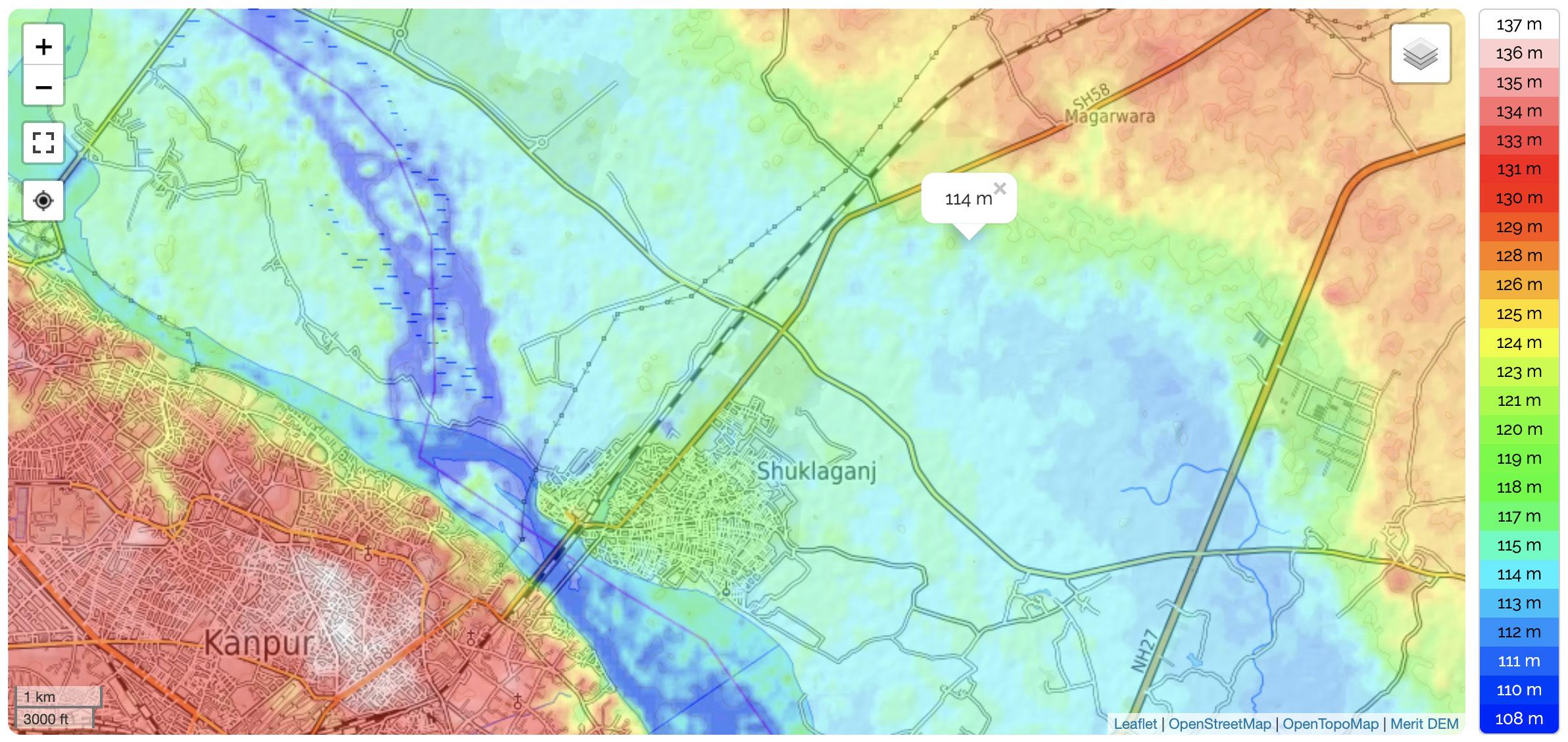
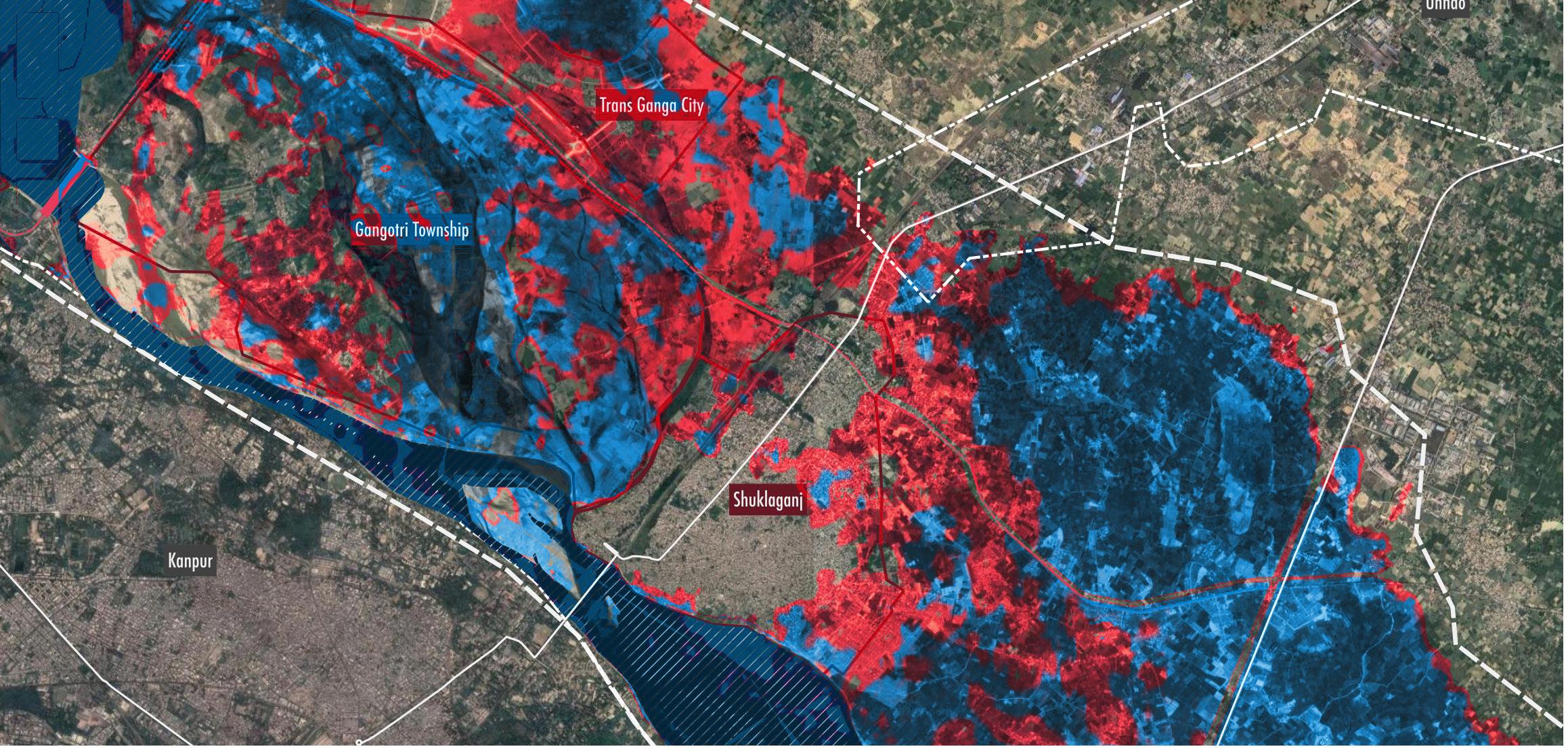
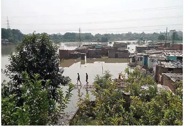
1 km 6 km up
114m 115m
to
Fig. 49: Image showing regional condition of settlements around Kanpur flooded and underwater in 2010.
Fig. 50: Digital Elevation Model (DEM) showing the informal settlement of Shuklaganj mainly lying in the elevations between 115m to 123m.
95 Politics of Land
Fig.51: Digital Elevation Model (DEM) at Brijghat showing in red how far river water reached in 2010 and showing in blue how much area would be further under water if water levels rose another meter to 115m.
to ecological urbanism. Raising concern about emerging concepts such as ‘eco-urbanism’ or ‘ecological restoration’ which he even dubs contemporary versions of ‘eco-apartheid’. Further more, such politically incentivide projects oftentimes displace communities that like in low population density rural regions at the urban fringe, where the planning attitude it in favor for urban growth for a prosperous nation (Dutta, 2009) at the cost of a few individuals. All the while, great valuable knowledge of land and water that exists within the local displaced communities is lost and any concern of flood of the region is dismissed by the argument of technological and engineered solutions that provide flood prevention methods of modern development schemes.
Most prominent of the three upcoming hi-end development projects is the Hi-tech TransGanga City. Planned over an area of 1144 acres and to be a model project highlighting sustainable development features as promoted by the Uttar Pradesh State Industrial Development Authority (UPSIDA) website ‘with the design level elements required to make the city sustainable’ as well as the ‘implementation of green roof, earth cooling, solar panels, ground water recharge & waste management’(source). Not only do these buzz words such as ‘earth cooling’ sound outlandish, the sheer attitude of what Gandi (2015:152) terms ‘unsightly’ becomes clear in the renderings of the planners as no call-out or demarcation of the Shuklaganj community exists in the published renderings and masterplans for the new satellite towns on the official website of the UPSIDA (see Fig. 53-54).
Through analysis of such case studies as the four floodplain settlements in Kanpur highlight the high level of socio-economic disparity that exists towards development efforts for different communities. If we talk of sustainability, we must also talk of equity and a strategic displacement of unwanted communities is not just unethical within the realm of urban planning, but unsustainable to it’s roots as the so-called unwanted condition is either ignored or removed- just to reappear in a similar location along the river somewhere else. Instead, the approach must be more inclusive and long term if Kanpur wants to take a step towards a more honest form of sustainability of its city and larger metropolitan area.
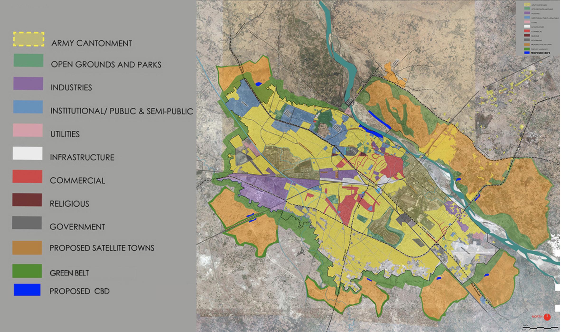
96 Ganges River in the Age of the Anthropocene
Fig. 52: Masterplan design by Kanpur firm Design Pendulum, 2016.
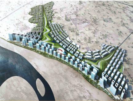
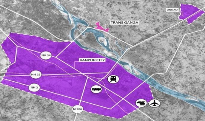 Fig. 54: Rendering by Studio Symbiosis showing proposed Masterplan for Trans Ganga Hi-tech City, 2016.
97 Politics of Land
Fig. 53: Rendering by Studio Symbiosis showing development design for Trans Ganga Hi-tech City, 2016.
RIVER FLOODPLAIN SETTLEMENT TYPOLOGIES
The observations at Brijghat as well as case study of floodplain sites in Delhi and Kanpur, show how different communities within the floodplains have their own agency that require close proximity to the river while each of them also have a a set of demands and impacts on the floodplain, the rivers and the water cycle.
In Brijghat (rural), the floodplains provide fertile soil for rain-red agricultural farming within the sandbanks and along the banks of the river.
In Delhi (urban), a constant increasing trend in urban migration is pushing a city with close to 23 million inhabitants and few undeveloped land to find land for new development projects within floodplains while displacing current agricultural communities that have lived there since decades.
In Kanpur (in transformation), formal development is attracted to the floodplains for it’s proximity to the river and lucrative promenade development while informal settlement find in the floodplains an alternative to formal water infrastructural where the river is able to provide easy means for wastewater disposal.
Yet, while each of the settlements equally encroach into the floodplains, the legal status of each settlements is different, protecting some settlements from evictions and state demolitions while others remain vulnerable. To better understand each of the studied encroachment site based on their interaction with the water cycle, river and the floodplains they inhabit, they are categorized into typologies based on two main parameters:
1. Legal rights to land-use of settlements within floodplain (formal / informal)
2. Settlement proximity to the city and population density (urban /rural)
Out of this logic along two main parameters, four main typologies of settlement encroachment into the Ganges River floodplains are formulated that start to compare how much each typology has access to state funded water supply and waste water treatment infrastructure (see Fig. 55). Further, these four typologies are drawn up to understand also their positive and negative externalities on the natural water cycle of floodplains as well as which government departments have influence over water access and land use (see Fig. 56 - 59, on next two pages).
98 Ganges River in the Age of the Anthropocene
Informl - Rural
Self-organized demarcation of leased land with limited work status for economic activity
(see illustration
Fig. 56, page 100)
No access to state funded wastewater treatment infrastructure, fresh water acquisition through private tubewells into the ground
Low inhabitant density within settlements
Low inhabitant density within settlements
Forml - Rural
Clearly defined boundaries of privately owned parcels of land with legal work status for economic activity
(see illustration
Fig. 57, page 101)
No access to state funded water supply for households
No access to state funded water supply schemes for irrigation
No access to state funded wastewater treatment infrastructure, disposal of wastewater without treatment back into the river or nearby natural water body
N/A
No access to state funded water supply for households, fresh water acquisition through private tubewells into the ground
(see illustration
Fig.58, page 102)
Settlement consisting of mostly unauthorized construction within or near an administrative boundary of a city Informl - Urban
High inhabitant density within settlements
High inhabitant density within settlements
No access to state funded water supply for households, fresh water acquisition through private tubewells into the ground
Access to state funded water supply schemes for irrigation
No access to state funded wastewater treatment infrastructure, disposal of wastewater with treatment through simple septic tanks construction
Access to state funded water supply for households, additional fresh water acquisition through private tubewells into the ground
N/A
Access to state funded wastewater treatment infrastructure, additional wastewater treated through simple septic tanks or disposal into street level open surface drains on street level
(see illustration
Fig. 59, p. 103)
Settlement within clearly defined administrative boundary with a governing body in charge of urban development through zoning and land-use planning
Forml - Urban
99 Politics of Land
Fig. 55: Typologies diagram of settlements typologies within the Ganges River floodplains.
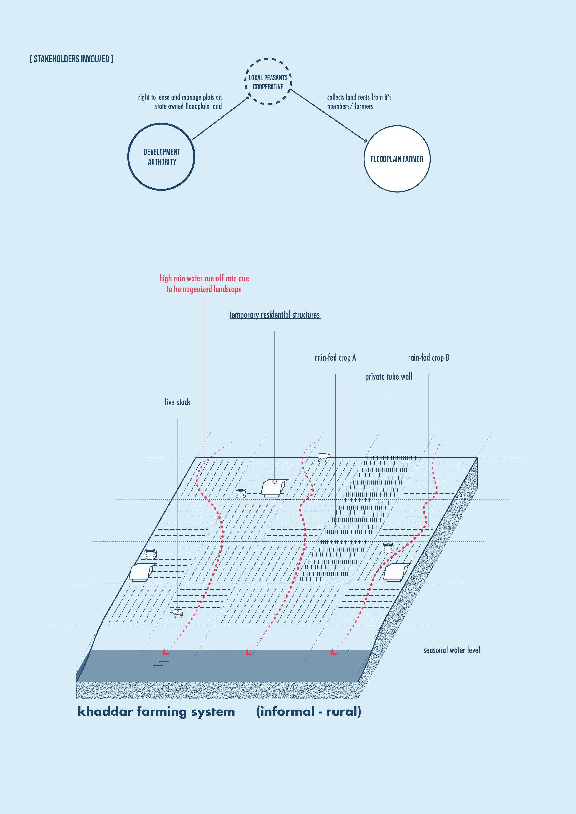
100 Ganges River in the Age of the Anthropocene
Fig. 56: Typology diagram of impacts of a informal - rural floodplain settlement on the natural water cycle.
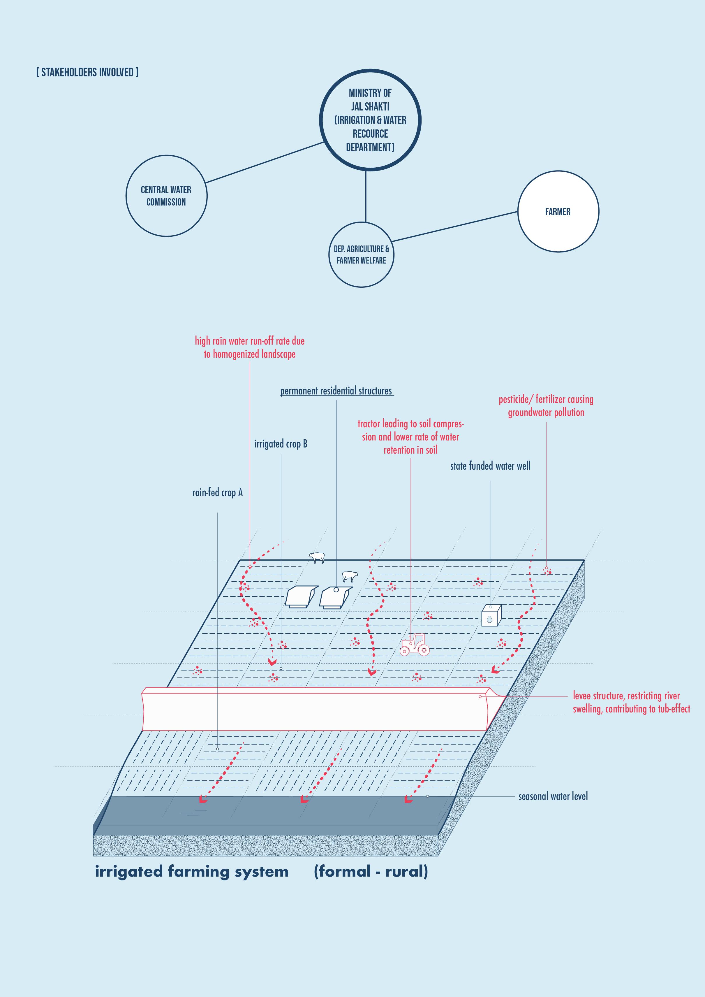
101 Politics of Land
Fig. 57: Typology diagram of impacts of a formal - rural floodplain settlement on the natural water cycle.
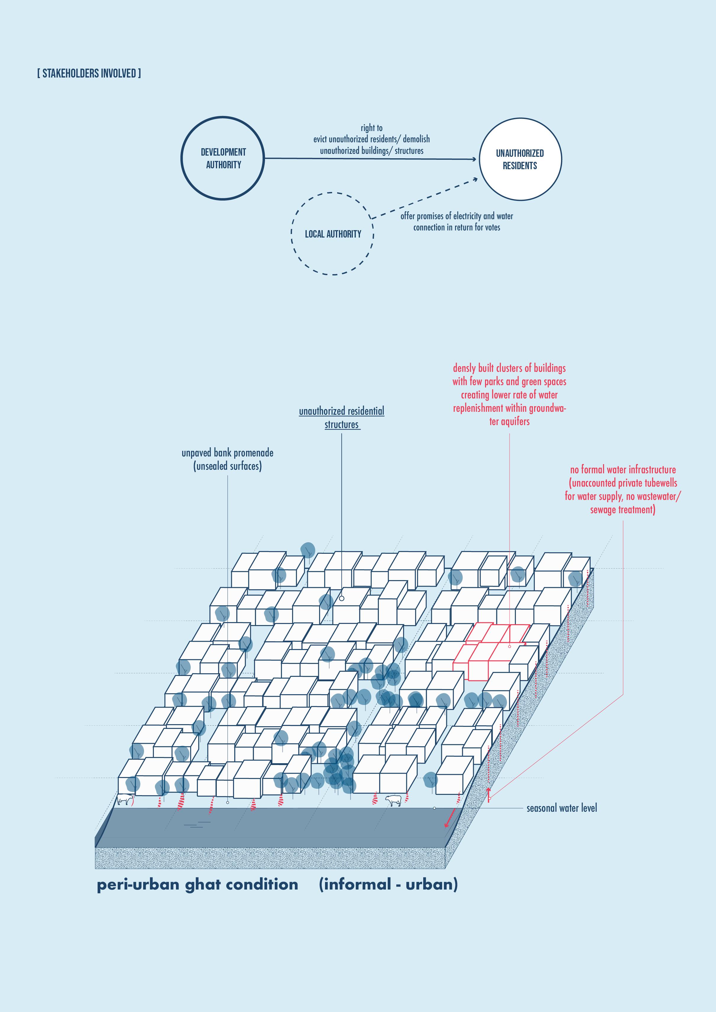
102 Ganges River in the Age of the Anthropocene
Fig. 58: Typology diagram of impacts of a informal - urban floodplain settlement on the natural water cycle.
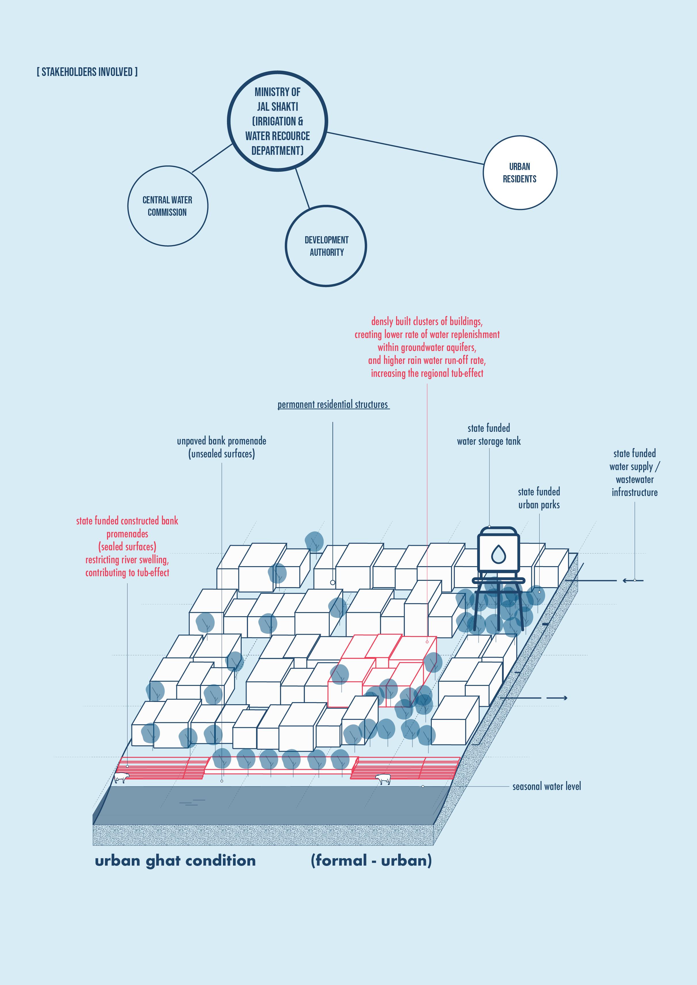
103 Politics of Land
Fig. 59: Typology diagram of impacts of a formal - urban floodplain settlement on the natural water cycle.
CHAPTER SUMMARY FOR POLITICS OF LAND
By comparing the three very different floodplain encroachments between a rural setting in Brijghat, an urban setting in New Delhi and one in a state of rapid transformation site in Kanpur, certain disparities in floodplain encroachments become clear:
1. Not only rural or low income settlers migrate into floodplains due to lack of better opportunities but rather even state institutions and private developers take the risk of settling into floodplains in order to benefit from promenade views of the river that bring in higher profits for developed units close to the river.
2. Without proper floodplain zoning, the disparity in land ownership and legal protection of encroached lands will always remain high between those who can afford to win over local officials favor and obtain legal construction documents, and those who remain at their mercy but often face eviction and demolition of their homes as they have no long-term land rights of state owned land.
3. Often sporadically planned formal and informal settlements create major challenges for planners and engineers who use the tool of river infrastructure to redefine and design new flood zones, flood reach and severity, but are unable to include future informal settlements that might appear in the next decade or century, often leading to newspaper headlines where the opening of floodgates of a dam mostly causes flooding of newly built settlements within the floodplains.
4. Yet, these encroachment settlements make up a large portion of the countries population, most of which are not yet fully seen and represented in the planning process and also vice versa, informal residents rely on word of mouth and local water literacy but are not made aware by politicians, planners or engineers that the regions they reside in are categorized by planners as high risk zones for designed floods.
In all these cases, the analysis shows that floodplains have little legal status as the planning and governance over these flood prone areas is not defined by law. Without any planning and construction guidelines, the inhabitants are left alone in their situation, oftentimes leading to poorly planned and constructed structures, increasing their vulnerability to floods while also creating harsh environments that lead to degradation of ecosystem services, biodiversity and the rivers aquatic health.
104 Ganges River in the Age of the Anthropocene
105 Politics of Land
106 Ganges River in the Age of the Anthropocene
Open wastewater drain
Informal
Pigs foraging for food amongst trash along a small patch of natural embankment structure left unpaved along the paved promenade in Kanpur City.
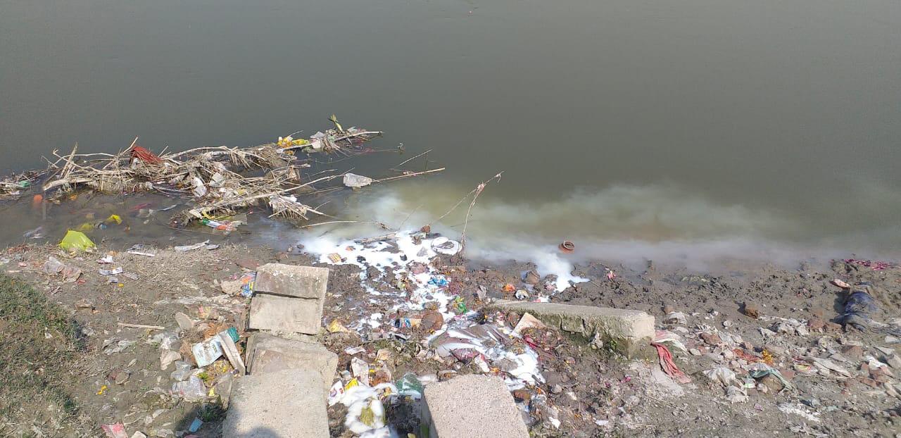
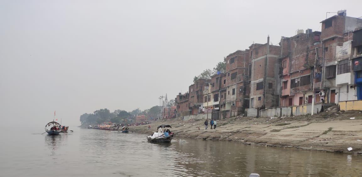
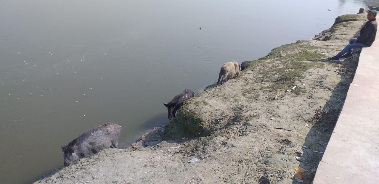
107
F
flowing into the Ganges river at the Ghats in Kanpur City. G
settlement encroachment on top of embankment structures along the Ghats of Kanpur City. H
POLITICS OF WATER
From the fertile valley to the fatal valley
Local impacts
Regional water stress factors
Translocal effects
108 Ganges River in the Age of the Anthropocene
Fig. 60: Diagram showing types of impact of floodplain settlements.
In the last chapter, I would like to focus in on water management planning within a rapidly growing urban site along the river by focuing in on Kanpur Metropolitan Area’s 30 km long stretch along the Ganges River. By analyzing the impacts of floodplain transformations and looking closer into the planning process by which the city plans to meet future water demands of a growing population, the chapter aims to explore how much are floodplains affected in the future growth of Kanpur City and how are these implications accounted for in the regional water stress factors locally and translocally (see Fig. 60). Lastly, the chapter explores how the process in water planning and management currently neglect minority communities and non-human species especially of riverine and floodplain habitats. This leads not only to cultural impoverishment but also to species extinction while also having wider implications for climate change and in turn the future of all inhabitants.
109
“Water is not simply a material element in the production of cities but is also a critical dimension to the social production of space.”
(Gandy, 2004)
LOCAL IMPACTS OF FLOODPLAIN SETTLEMENTS
Locally, urban settlements can create instances of regional water stress (see Fig. 61) as the demand, meaning the extraction of water from natural sources of water like rivers and ground water is higher than the rate of replenishment or refill rate of the water source through means of rain. As urban regions experience high waves or urban migration into already dense urban regions the regional water stress rises, leading to moments where water demand is so high that it quenches dry a strategic water well, ground water aquifer or even a river for certain periods of time that could last one season or as long as many consecutive years. (Hofste, Reig and Schleifer, 2019)
Additional settlement encroachments into floodplains can increase that regional water stress factor, by not only increasing the regional water demand but by also systematically decreasing the water replenishment rate within groundwater aquifers through construction of sealed surfaces of floodplain areas that were previously unsealed, creating a sort of tub-effect (see Fig. 62). The process of natural filtration of water as it goes through the layers of soil is one of the very important ecosystem services by floodplains (Why should we care about floodplains, 2018) many communities depend on as they consume untreated groundwater as their only means of access to clean water.
Along with increasing the regional water stress factor, floodplain settlements also contribute to more extreme flood events. Formal urban settlements encroaching floodplains build higher and higher embankments and straighten out the rivers naturally sloped valley, a type of riverpinching-effect (see Fig. 63, on next page) diminishing the floodplains two most important natural characteristic of slowing down water flow rate and decreasing the ability of soil to absorb water. Excessive sealed surfaces within floodplains diminish the floodplains ability to act as a natural buffer zones that decreases flood severity by acting as a natural ‘sponge that absorbs water’ both from rain water run-off as it makes it way down the sloped river valley towards the river channel but also by absorbing water of a swelling river. Instead the floodplains effects are reverted as excessive sealed surface within the sloped valley start to act like an artificial ‘tub that repels water’ an thereby increasing the water runoff rate, leading the river to swell up even faster during flood events. As the total length of embankment structures increase within the main river and it’s tributary stretches, the flood events of remaining floodplains will keep getting more severe. The overall river pinching effect creates pressure not only on floodplains but also on dams and barrages, which if kept closed, contribute to
110 Ganges River in the Age of the Anthropocene
[ regional water stress ] [ tub-effect ]
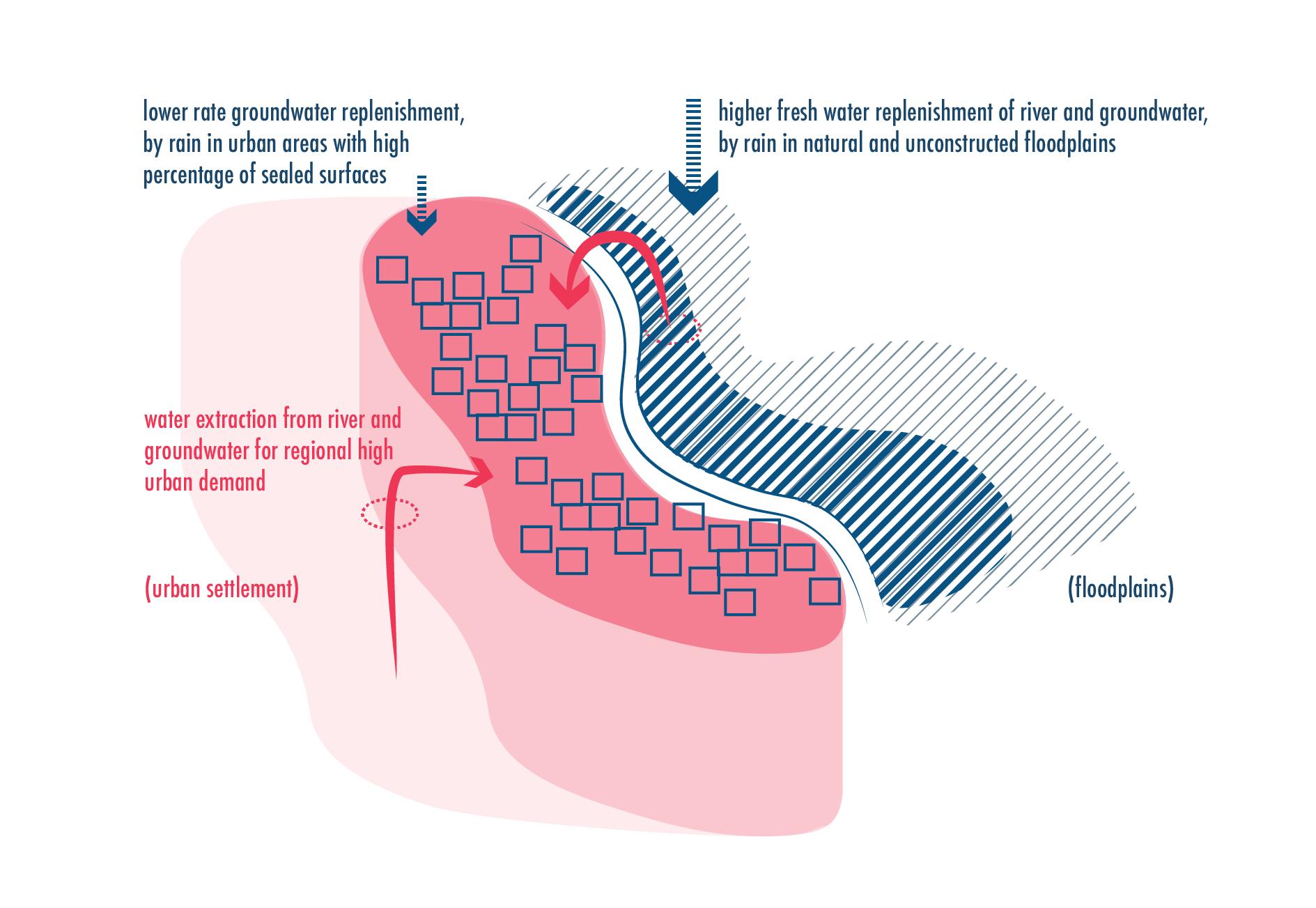
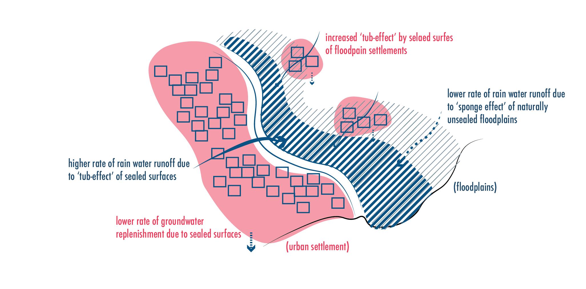 Fig. 62: Impacts of high amounts of sealed surface areas on the rainwater runoff rate.
111 Politics of Water
Fig. 61: Impacts of high water demands of dense urban regions on the groundwater.
more severe flooding upstream, and if opened, lead to more severe flooding downstream. This puts especially those communities at risk that can’t afford expensive technical solutions of engineered levee and embankment infrastructure for themselves. (Rossano, 2021)
Lastly, sealed surfaces keep groundwater levels naturally low as overall water replenishment rate is decreased. This leads to a consistent trend of decreasing groundwater levels over the years, eventually also leading to floodplain’s ecological degradation (see Fig. 64). Many plant, animal, and insect species that live in the soil rely on stable ground water levels within their habitats. Strong annual fluctuations in the groundwater level can lead to long periods of soil dehydration, causing death to many species of plants, insects and animals that rely on stable soil humidity levels. These unbalanced and endangered habitats not only lead to species loosing their habitats regionally, but we as humans also rely on their daily activities within the soil to keep the soil health in good conditions, essential to good crop growth planted by humans. (Why should we care about floodplains, 2018)
WATER ACCOUNTING FOR KANPUR METROPOLITAN AREA
In the case of Kanpur City’s four floodplain encroachments, the question is no longer one of just legality of land-use but also it’s implications of water accessibility for all communities and species living within it, as well as it’s impact on extreme flood events throughout the region.
A method by which cities ensure the long term water availability in their region is through a methodology called water accounting. By determining the current fresh water sources and their capacity, it calculates and evaluates the cities water demands, treatment capacities and potential risk factors to long term supply. One such study was also carried out for the Kanpur Metropolitan Area (KMA) by Bassi (2019) to study the long term water demands and wastewater discharge of the dense urban metropolitan area of Kanpur (see Fig. 65, on next page). Yet, by analyzing this study it became clear, the issues of equity within water accessibility for all communities of the region is not accounted for, mainly as it depicts a snapshot in time of how the city’s water demands compare to available water in the region rather than projecting any longterm impacts of urban settlements on the water availability of it’s sources.
The results solely focused on availability of water in the long term based on current conditions of river discharge and groundwater replenishment and only consider a change in domestic and industrial use as a variable, while the water source availability is understood as a constant. But implication of projected floodplain transformations through for example additional settlement encroachment are not considered, giving in my opinion a rather too optimistic outlook for the region which is not considering any long term degradation of ecology, and overall climate change implications which not only impact the river discharge quantity in the longterm but also the rate of groundwater replenishment within the aquifers.
To understand the implications of floodplain transformation a two step study is conducted: In step one, the water accounting numbers from Bassi’s study (2019) for KMA is mapped as a linear metabolism model. Such a model is understood in urban studies as the total consumption
112 Ganges River in the Age of the Anthropocene
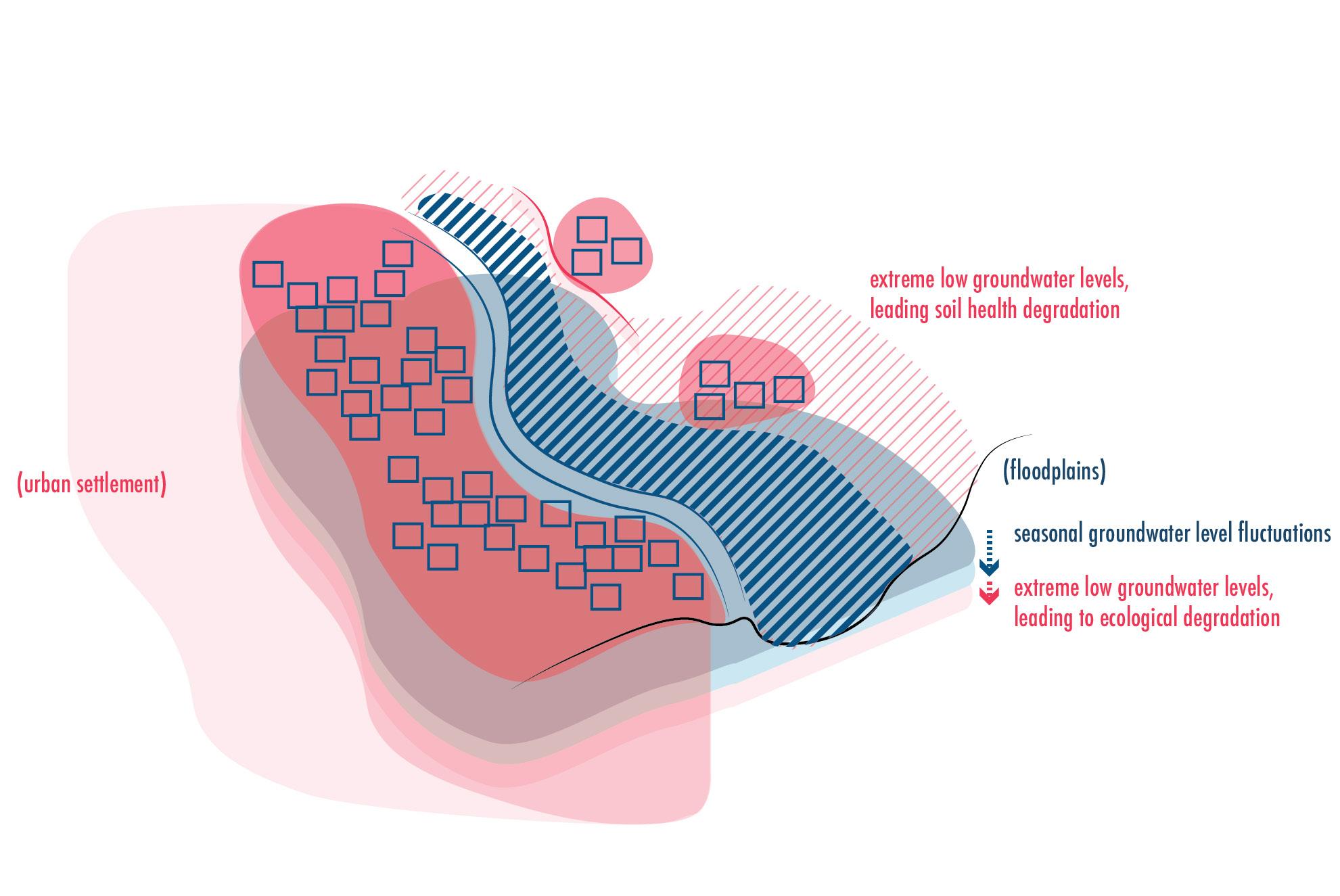
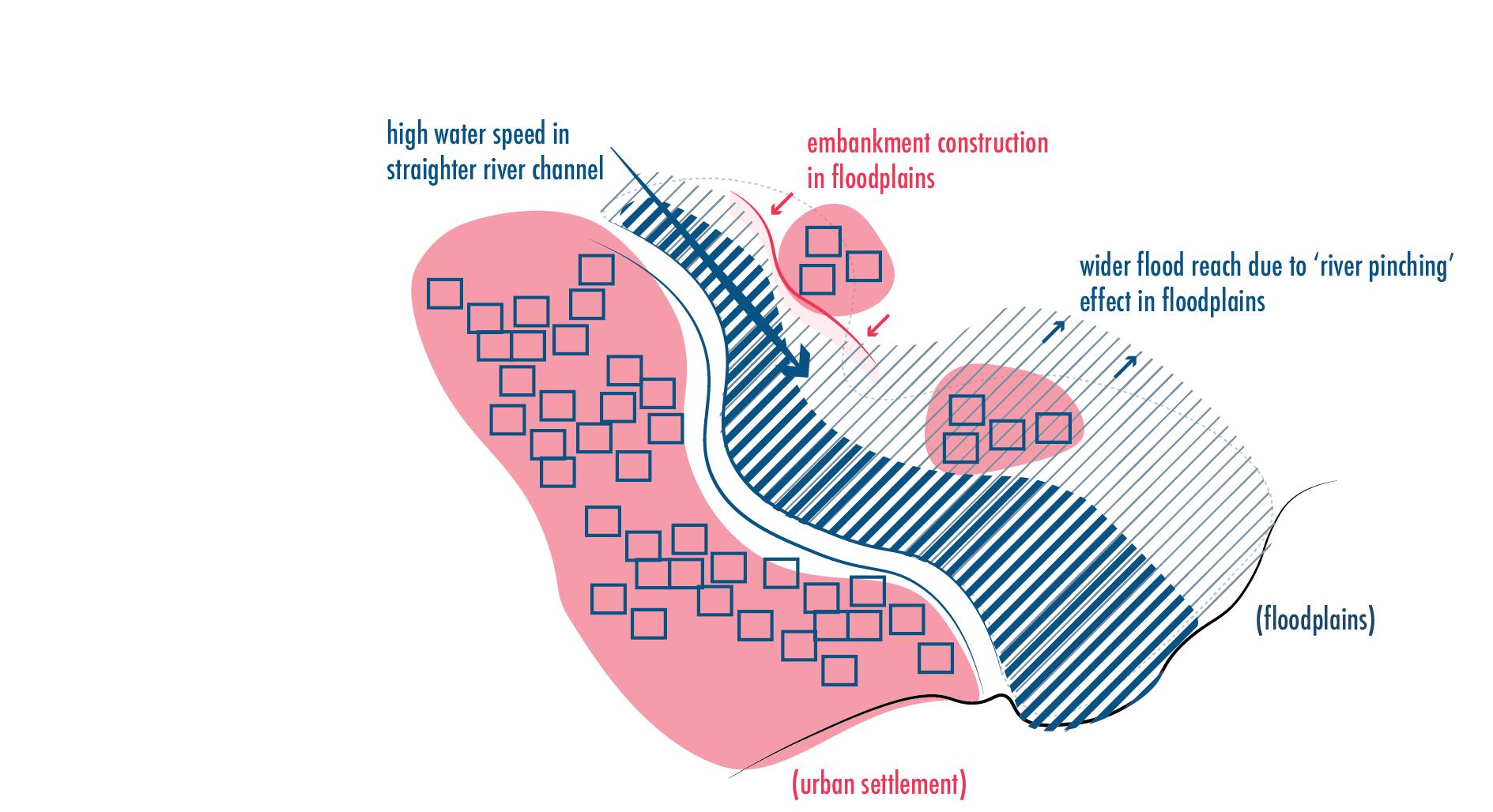
[ ecological degradation ] [ river-pinching effect ]
Fig. 64: Impacts of high annual fluctuations in the groundwater on the regional floodplain ecologies.
113 Politics of Water
Fig. 63: Regional impacts of embankment structures on the river flow.
or metabolism of a city or study region as made up of it’s resource inflow and outflow (Gandy, 2004), yet in this case, the model focuses only on the resource of water (see Fig. 66).
In step two, qualitative data on floodplain transformation collected throughout this thesis (politics of river infrastructure/ land/ water) is annotated onto the mapped metabolism model in order to represent not only the regional water demands but also the overall regional implications for floodplains and their longterm impact by new settlement encroachments into it. Bassi’s (2019) report lists following data for water demands, supply and discharge for Kanpur:
Fresh water sources available:
Public Health and Environment Engineering Organization (CPHEEO) of India)
the most polluted stretch of the entire 2700km stretch)
water extraction (installed capacity before 2005) with new barrage construction (i.c. after 2005)
loss of acquired water
to water thefts, leaky pipes, etc within water distribution network)
of which, pumped and treated Ganger River water
of which, drawn from groundwater (depth between 6-16m, general decline trend of 9.6 m)
generated
projections:
Water demand by 2031 (domestic and industrial)
of which, domestic
of which, industrial increase from 844 MLD (2006)
Fig. 65: Chart representing water accounted data as accounted for in the study by Bassi (2019).
114 Ganges River in the Age of the Anthropocene
River discharge annual daily per second 53 billion cubic
145 million
1679 cubic meters per
(cumec) Groundwater quantity annual net total daily net total annual surplus quantity maximum daily extraction 1475 MCM 4041 million liters per day (MLD) 612 MCM 1676 MLD Total water extracted: River water extracted annual daily (2011) daily (2031) Groundwater extracted (domestic
annual daily ? 255 MLD 785 MLD 863 MCM 2364 MLD Domestic Use: Water
(Central
150 LPCD (liters
Population size in 2011 (Kanpur
3.2 million Average population density of Kanpur
9666 persons/km2 (2011) Water demand annual daily 175 MCM 480 MLD Ganges
(currently
30 km (approx.) Fresh
600 MLD upto 1600 MLD Water
(due
30% Water
385 MLD
255 MLD
130 MLD Wastewater
Kanpur Metropolitian Area Kanpur City Unnao Municipal 767 MLD 339 MLD 24 MLD Wastewater treated: wastewater treatment capacity
KMA Kanpur city (29% of total wastewater generated) Unnao 400 MLD 210 MLD 19 MLD Industrial Use: Water demand 308 MCM Water supply private groundwater tubewell extraction 844 MLD Wastewater generated Kanour City Unnao other KMA 259 MLD 54 MLD 91 MLD Future
1629 MLD
+400 MLD
(no increase projected)
meters (BCM)
cubic meters (MCM)
second
+ industrial+ irrigation)
demand per capita
per capita per day)
City)
Metropolitian Area (KMA)
River stretch by Kanpur City
supplied (actual)
for
Total

115 Politics of Water
Fig. 66: Mapping of water demand data as accounted for in the study by Bassi (2019).
The study by Bassi (2009) concludes with the water accounting methodology water demands will be met till 2031 for Kanpur with current infrastructure in place and the current fresh water availability.
Yet, it does not include the following implications:
- regional water stress through existing settlement of Shuklaganj with 84,000 inhabitants living in floodplains, where all inhabitants pull groundwater through private wells
- tub effect through the construction of three additional formal settlements also planned in the floodplains that are planned to be done within the next 10 years
- at first glance, that would also indicate a decrease in annual replenishment rate of groundwater by 24%, as the three new settlement seal up 65 km2 of the total of 270 km2 within floodplains
- increase of sealed surfaces within floodplains of the 35 km river stretch along Kanpur by 27%, making up 72 km2 of the total 270 km2 floodplain area
- river pinching effect through new highway construction passing by the Trans Ganga Hitech City and New Kanpur City also impact floodplain reach by another 27% as they decrease close to 70 km2 through constructed embankments on which the highways are build on
All these qualitative data and annotations show the rapid transformation within the 35km stretch of river floodplains by Kanpur City (see Fig. 67), indicating that close to 54% of the original floodplain area are highly impacted. Not only does this increases the rate of river swelling during monsoon, leading to higher flood events in the region but it also indicates a lower groundwater replenishment rate during monsoon as overall floodplains area is decreased through sealed surfaces or embankments.
116 Ganges River in the Age of the Anthropocene
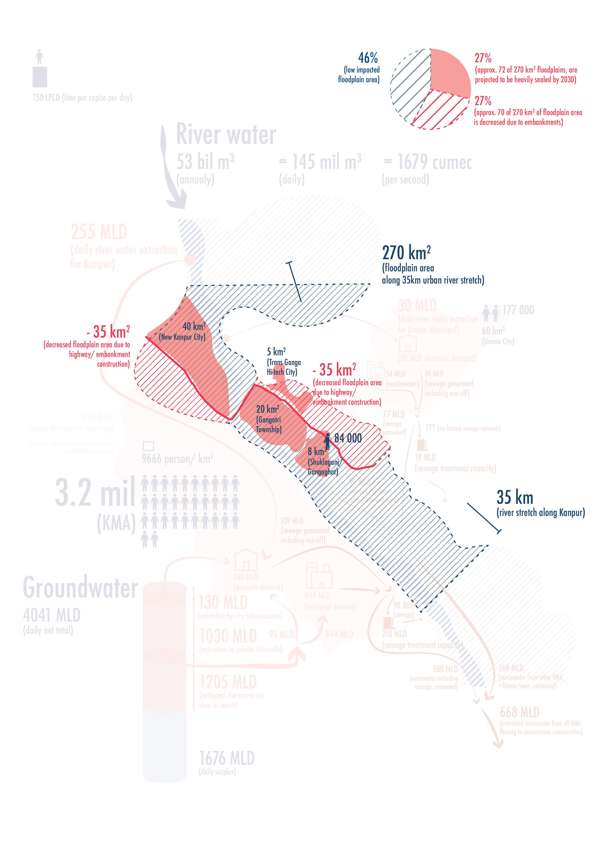
117 Politics of Water
Fig. 67: Mapping of additional qualitative data of impacts on the natural water cycle through floodplain transformations.
What the study (Bassi, 2009) does recognize is that all these calculation are based on annual average numbers and don’t reflect the reality in moments of extreme weather events where cloudbursts or long months of drought can lead to high deviations from current calculations.
Two such extreme opposite conditions of water availability are highlighted by studying the rivers water levels in Kanpur during the month of September in the year of 2010 in comparision to 2015 (see. Fig. 68):
On 29th September 2010, Kanpur City experienced its highest water levels in the Ganges River due to consecutive days of non-stop rains. Water levels rose to 6 meters above it’s normal levels reaching a total of 114.07 meters with an average discharge rate of 17 000 cumec, even though the usual monsoon season (June - September) water level average of the river is as 1679 cumec (Bassi, 2009: 252). Which means the river swell up to 10 times its average volume over a course of a few days.
In complete contrast, five years later in September 2015, the monsoon rains were terrible with only four days of rainfall between the months of June till September with a recorded participation of 405mm, almost 200 mm less than the total average rainfall for those four months (Malhotra, 2015b). This lead to an extremely lean river with water levels of the river dropping down to 109.70 meters and only 443 cumec water flowing in the river by Kanpur. In the case of Kanpur, the city had to keep 22 of it’s 30 barrage gates shut in order to artificially hold back enough water to provide enough water for its upstream pumping station by the barrage to be able to pump the required 1600 MLD for its inhabitants. Many scientist and environmentalists are concerned that such large scale planned encroachment into floodplain sites may cause to much pressure on an already high regional water stress area of Kanpur and poses long term treat for the Ganges River where seasonal conditions of rain along with high water demands of the city could choke the river completely dry (Sengupta, Down to Earth).
Here, river infrastructure is used not only as a tool of river calibration for equal use but rather calibrated for optimal use by the more powerfull stakeholders. The irrigation department of the state prioritizes the need of water for the inhabitants of Kanpur as well as the farmlands that have subscribed to the irrigation schemes. An irrigation officer in charge of the barrage in Kanpur reported of exactly such priorities to the local newspaper: ‘We don’t have enough water and we are therefore, releasing it with utmost care’ (Malhotra, 2015a). Such scenarios where river infrastructure is implemented to ration water supply for some while cutting it
118 Ganges River in the Age of the Anthropocene

119 Politics of Water
Fig. 68: Graph showing Ganges river’s annual data by Kanpur City for average water level to average precipitation along with flood and drought events.
off for others is systematically creating a scenario of inclusion of its own subscribers and exclusion of those unsubscribed both in the region as well as further downstream.
Such scenarios Gandy (2004) explains can be understood as ‘a technocratic and rational model of municipal managerialism’ while new logics of river infrastructure create ‘a connection between urban infrastructures and citizenship rights’ (Gandy, 2004). The right of each citizen to equal access of water no longer exists posing new local implications between inhabitants who are connected to the formal water infrastructure of the city and those who need to get by on their own.
Yet, the implications of such large scale intervention through river infrastructure also goes beyond calibrating natural water networks access for it’s stakeholders but also forces those left behind to new structures of operations along rivers. As explained in a local newspaper by a agronomy professor:
‘farmers having tubewell facility, will be able to irrigate their crop but the small farmers who are dependent on rains will be at a loss [and instead should] opt for integrated farming system ...[where they] use the same farm for cash crops, vegetables and also make use of phosphorous to have good yield’ (Malhortra, 2015b)
These are all methods of industrial farming that force the farmer to abandon methods based on rain-fed farming in order to be able to grow cash crops and use fertilizers (made out of phosphorous) efficiently. This shows that not only do weather conditions dictate the method of farming but also installed river infrastructure operated by state officials dictate new logics of farming methods throughout the whole river basin.
120 Ganges River in the Age of the Anthropocene
ECOLOGICAL IMPLICATIONS OF FLOODPLAIN DEGRADATION
As urban settlements systematically take over floodplains, both formally and informally, it leads to many externalities (see Fig. 69, on next page). Beyond land-use changes from mostly agricultural land use to urban extensions sites, not only is the region gaining new sealed surface areas but its leading to displacement of many small river based communities who lose their source of income when floodplain and rivers ecological degradation also leads to loss of species who relied on such ecologies for survival, and as these species disappear, so does the source of income for these smaller river communities.
In the Kanpur region, many fishermen communities have been banned from fishing due to over-pollution of the water caused by sewage and industrial waste water dumping into the river. Loosing their means of livelihood, they had to resort to working in the construction industry as simple construction workers with below minimum wage. Very little efforts exist to provide any alternative mode of fishing or equivalent compensation by the industries who pollute and create this externalities (Maurya and Chowdhury, 2020). Yet, not only does Kanpur City lose these communities but also part of it’s own culture and tradition that was being kept alive through these communities activity and the valuable knowledge they had of riverine life. These are forms of ‘cultural impoverishment’ that Rossano (2021: 65) refers to when cities mainly focus on draining a valley and homogenize it’s landscapes for economic gain at the cost of loosing the weaker communities within the valleys reach (Rossano, 2021).
Another such ‘cultural impoverishment’ is also the rare siting of the endangered species of Ganges river dolphin which can only live in fresh water of the river and can’t go out to the ocean, yet through habitat fragmentation created through dams and similar structures, their habitat is restricted while heavy pesticide and fertilizer contamination from nearby agricultural fields along the banks contribute highly to their almost extinction throughout the whole rivers stretch. Currently, less than 3000 Ganges River dolphins are expected to be still alive in the river, most of which live in the delta region below Kolkatta. (Sinha, 2021)
As floodplains lose their last wetlands through new agricultural or settlement construction, important habitats for many endangered animal species that live in seasonal buffer zones between seaweed in shallow waters to high grass on adjacent land are also going extinct. Fish that usually lay their eggs in shallow and slow flowing streams of the river, lose their habitat
121
Politics of Water
to straighter and fast flowing channelized rivers. These and many more forms of landscape homogenization will not only lead to impoverishment of recreational spaces that are mainly reduced down to a park with a patch of green grass and no real element of ‘experience’ left within them but also create further disconnect between inhabitant and the environments they live in and impact through their actions.
CLIMATE CHANGE IMPLICATIONS
Lastly but probably most crucial, is the direct impact of floodplain settlement encroachment on climate change. Ecological degradation and species extinction is the biggest disrupter for healthy soil, which as it starts to degrade, not only leads to lower crop yields, but also directly contribute to higher carbon emissions released into the air. Healthy soil promotes high levels of plant growth and microorganism that actively store carbon within their cells, making soil of the three natural carbon sinks, alongside oceans and forests, we currently have on our planet. But as soil degrades, plants and microorganisms die, releasing the stored carbon back into the air. As reported by Hinshaw and Wohl (2021):
‘floodplains constitute about 9% of total land area. Although the range of soil organic carbon stock (Mg C/ha) reported for floodplains is too large to justify assuming a single median value, soils are the largest terrestrial carbon reservoir and wetland soils have higher carbon concentrations than other soils. Wetlands store 20–30% of the estimated 1,500 Gt of global soil carbon, for example, but occupy 5–8% of land area. These numbers suggest that wetland floodplain soils can cumulatively create globally significant carbon sequestration.’
In conclusion, floodplains transformation through construction of river infrastructure, land use changes and higher water demand trigger soil erosion processes from all three factors on one of the last remaining natural landscapes with healthy soil and natural carbon storage areas. But, high human impact could turn these landscapes into high carbon emitters in the near future- making our problem of global warming that much worse.
122 Ganges River in the Age of the Anthropocene
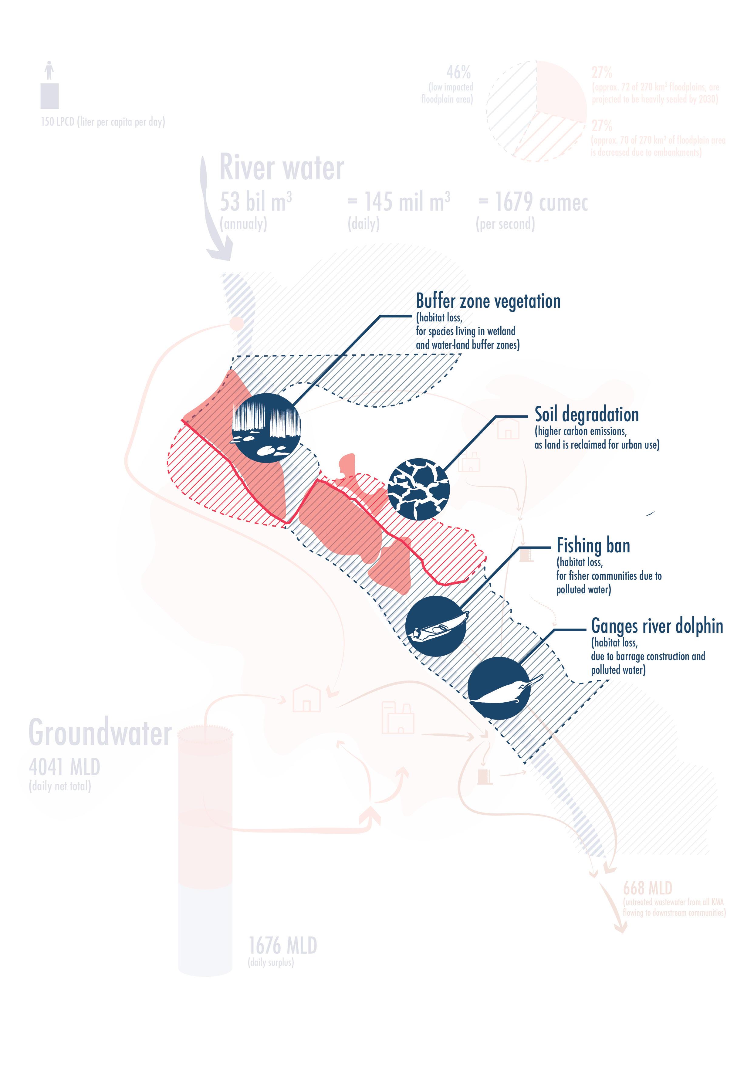
123 Politics of Water
Fig. 69: Examples of floodplain transformations externalities.
CHAPTER SUMMARY FOR POLITICS OF WATER
When accessing the impacts of urban settlements on floodplains, a study must go beyond a ‘water accounting’ methodology that solely looks at the demands of a cities human inhabitants but also considers wider implications for floodplain ecology including the demands and needs of all species, including those which are non-human. Such a holistic strategy is not just an ethical responsibility for planners and engineers but rather also a sustainable approach towards environments which we hope to pass down to the next generations. In this sense, floodplain zoning is essential for any water resource planning study and floods as well as water demands can’t be planned without having a strong basis by which floodplains are properly surveyed, zoned and managed in the future. Such floodplains planning efforts must consider the following factors for future floodplain zoning concepts:
1. Local implication of acute regional water stress factors caused by high density urban settlements into floodplains such as:
- excessive sealed surface construction within floodplains that create a tub-effect, increasing rain water runoff rate and decreases the rate of groundwater aquifer replenishment,
- excessive embankment construction that create a river pinching effect, increasing again the river velocity due to less width of river floodway, while decreasing further the groundwater replenishment rate as water flows by faster on steeper terrain and soil has less time to absorb water,
- excessive ecological degradation which also impacts soil health, making soil in floodplains less fertile and decreasing its ability to absorb water and replenish groundwater.
2. Move beyond linear models of urban metabolism for water where methodologies like ‘water accounting’ could produce misleading conclusions where total demand is satisfied when total availability of water is greater, but instead see how we can keep the same water in as many repeated water use cycles within the city in order to reduce water stress factors on ground water.
3. We must take into account the notions of large amounts of annual fluctuation in water availability within the river and groundwater by embedding such concepts into practices of space making as well as daily discourse of inhabitants and not just reserve such topics for catastrophe prevention strategies studied by experts.
124 Ganges River in the Age of the Anthropocene
4. Healthy floodplain ecology could be not only beneficial for species habitat but also contribute to cultural enrichment though the production of heterogeneous landscapes that cater to the needs of various sub-communities who require varying conditions beyond those found within a dense urban setting.
5. Floodplains must be considered for their healthy soil conditions and natural water to land relationship which contribute towards a balanced process of carbon emission and sequestration, and if floodplains are neglected and degraded over time they might experience high levels of erosion, transforming them from carbon storage into carbon emitters, contributing to overall global warming factors and essentially making the problem of floods, on a global scale, that much more severe.
All these considerations towards water sensitivity by various settlements in floodplains not only allow for their future existence but also empower communities that have valuable knowledge of water and land and give this knowledge a proper space to be shared and celebrated as part of identity making of the city.
125
Politics of Water
126 Ganges River in the Age of the Anthropocene
THESIS STATEMENT
127
A STRATEGIC DISCONNECT FROM FLOODPLAINS
Ganges River Basin underwent a systematic river transformation in the last 300 years through the global rise in demand for agricultural goods, both in the form of cash crops under the British Colonial Rule over India as well as food security demands of Independent India.
A rising populations food security demands has led the country down a path of converting land-uses from rain-fed agriculture that worked with natural cycles of water to irrigated agriculture that yields higher output while also demands controlled river flow, constricted river reach and high level of water calibration to equal out fluctuations of natural weather patterns, leading to its current state of systematic dependence to river infrastructure.
A strategic expansion of river infrastructure for agricultural use has shifted political agency towards a skewed political landscape with high level of disparity in subsidies with high subsides given to those who favor the conversion of rain-fed agriculture to irrigated agriculture.
Through a constant expansion of river infrastructure once used for irrigation purposes, river infrastructure experienced a paradigm shift, being perceived as flood protection structures, giving a false notion of security within floodplain regions and triggering both forms of formal and informal urban settlement encroachment into floodplains.
Changes in floodplain land-use from natural environments of forests and wetlands to now engineered landscapes made up of hard engineered solutions, distinct borders have been set up between water and land. The promotion of irrigated agriculture has not only led to habitat and ecological degradation of wet zones within floodplains, but also to region wide soil degradation through industrialized methods of farming have diminished natural flood benefits which contributed to annual cycles of hydration and mineral replenishment in soils, keeping them fertile for the seasonal crops. All forms of soil degradation reduces soil’s ability of acting as a carbon storage site and instead threatening a conversion of soil to become future carbon emissions sites.
Similarly, urban encroachments into floodplains has increased total area of sealed surfaces within floodplains, increasing the rate of water runoff during heavy cloudbursts, creating an all-rounded tub-effect of the river basin where water-runoff in expedited and river flood events have become more severe.
128 Ganges River in the Age of the Anthropocene
In conclusion,
- a vicious cycle of catastrophic events with high levels of economic and personal damage can only be tackled by building up a renewed relationship of working with the water cycles of the river rather than constricting and eliminating it.
- Agricultural and non-agricultural activities that work with the natural cycle of the river need to be promoted and new relationships between floodplain activities and urban settlements with high negative impacts on the river’s overall health will need to be explored in order to reduce overall flood impacts created by dense urban settlements.
- New forms of productive landscapes and governance models of floodplains will need to be explored to promote river habitats for humans and non-humans that strive for healthy soil conditions for long term sustainability of local communities and traditions relating to floodplains while also becoming testing grounds for new models of sustainable economies that work towards protecting fresh water sources instead of polluting them.
129
Thesis Statement
130 Ganges River in the Age of the Anthropocene
STRATEGY PROPOSAL
131
FLOODSCAPES, A NEW DEMOCRATIC SPACE OF REFUGE AND CARE
RETHINKING THE ROLE OF FLOODPLAINS IN THE 21ST CENTURY
By understanding the politics that guided the development of river infrastructure within the Ganges River Basin as well as tracing the agency of food security that led to the neglected efforts of politics of zoning and planning floodplain regions, floodplains in their current condition are neglect and in a state of degradation. Not only for ecologies and animals who call these regions their home but also for the communities that formed large parts of cultural identity within the river and floodplain habitats along the river. From a colonial technocratic regime of the British who focused on constructing an ‘irrigation machine’ to an independent Indian State from 1947 onwards who inherited a system of dependency towards river infrastructure that could not be reversed.
Yet all these politics have mostly focused on economic growth, driven by technological advances in river engineering, all the while creating a systematic disconnect towards the countries own cultural roots to water and land, and neglecting the communities that most practiced such traditions within it. The status quo of floodplains if understood through its socio-political past and series of transformations reveals that floodplains as no longer a simple entity of land that is periodically flooded but rather a programmed system within a larger infrastructural network.
In it’s current state, the system is unbalanced, preferential to those in power and undefined of its new role. But this disparity becomes most clear in the contested floodplain sites within the urban river regions, and therefore the following proposal focuses on new logics of floodplains with particular attention to urban stretches experiencing high levels of urban migration at the moment.
Floodplain zoning in these regions can be the first step into this new role definition, that can alter the lives of those migrants who will settle into floodplains in the future. But rather than a distinct ‘functionalist approach’ (Gandy, 2004: 364), the planning of floodplains presents an opportunity to negotiate a role not only subservient to cities but one negotiated between river, ecologies and inhabitants. As floodplain zoning is not yet defined and drafted by the states, India has an unique opportunity to test new and varying models of floodplain zoning that has the potential to guide new communities and support it’s marginalized citizens to exciting new forms of living.
If floodplains of the present are plagued by urban pollution, floods and are disputed sites between powerful stakeholders of new high-end developments and marginalized urban
132 Ganges River in the Age of the Anthropocene
dwellers, floodplains of tomorrow could be spaces of democratic use towards refuge from homogeneous urban living and instead cater towards communities of care that rebuild and maintain a habitat diversity. Floodplain zoning and planning provides an opportunity to go beyond linear models of urban metabolism, where resources such as water are seen only from the lens of clean and waste water but instead guide floodplains into becoming experimental sites for circular models of urban metabolism where new communities within floodplains make the most efficient use of a scare water resource by not only connecting a second cycle of wastewater use from urban sites but also combining it with habitat reconstruction that can allow floodplains to continue replenishing groundwater of the region undisrupted and promote sustainable co-existence between humans and natures natural water cycles. A proposal of Democratic Floodscapes’ follows along the hopeful glim of new synergies between city and nature as imagined by Gandy (2004) in his essay Rethinking Urban Metabolism: Water, Space and the Modern City:
‘A dialectical or hybridized conception of urban metabolism can illuminate the circulatory processes that underpin the transformation of nature into essential commodities such as food, energy and potable water: the idea of metabolism in this sense derives not from any anatomical or functional analogy but from an emphasis on the interweaving of social and biophysical processes that produce new forms of urban or “metropolitan” nature in distinction to the rarefied realm of nature which remains dominant within much urban and environmentalist discourse.’
So in other words, nature and urban sites don’t necessarily need to be seen as two distinctly separate entities from one another where nature is kept and maintained within its ‘rarefied’ or untouched form within spaces such as urban parks, but rather through blurring these lines in a way where nature and its hosting ecologies can co-exist with urban sites and productive landscapes aren’t homogenized into agricultural farm land but rather kept heterogeneous, building stronger bonds between humans and habitats that can co-benefit from one another.
In order to explore such models of heterogeneous landscapes, floodplains, transient in their nature, can be explored as disconnected from capitalistic model of operation and instead turn into democratic Floodscapes: owned by none, governed by water and hosting productive synergies between all it’s inhabitants, both human and non-human
To achieve this, I propose the following five strategies...
133
Strategy Proposal
First, we must resurvey the floodplains, but this time, draw it from the perspective of water, and rather than defining encroached land through water levels marked by ‘warning levels’, ‘danger level’ and ‘highest recorded level’ as indicating level of damage, we must redefine water levels based on habitats, ecologies and communities it hosts. Defined floodplains must be returned back to communities where capitalistic logics of land acquisition don’t apply but rather it is community owned
land and leased only to economies that work with the cycle of water, towards soil regeneration and also create habitats for non-human species.
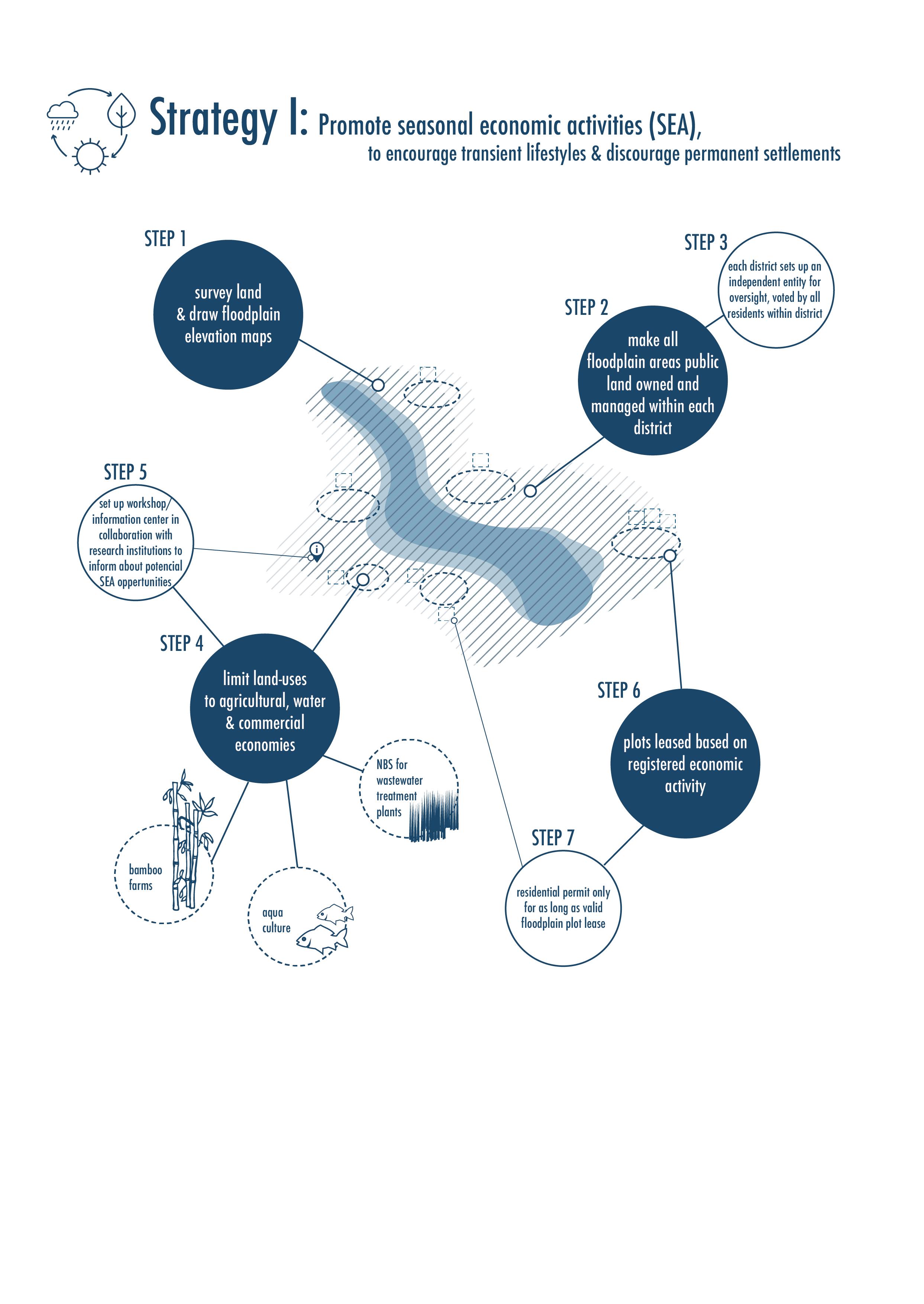
134 Ganges River in the Age of the Anthropocene
Fig. 70: Diagram of strategy-I.
Second, urban solidarity to floodplains must be rebuild through forms of leisure and educational infrastructure that makes not only the activities of the floodplains communities known to urban inhabitants but can also enrich their lifestyles and educate them about the importance of healthy floodplain ecology. By promoting seasonal events such as handicraft fairs, small farmers markets (sabzi mandi in Hindi), nature based solutions workshops, as well as constructing non-
intrusive mobility infrastructure such as hiking trails, bike lanes, boating docks, floodplains can act as sites that celebrate transient spaces and build awareness towards water- giving urban residents an opportunity to experience old traditions of floodplain farming as well as participate and observe the upand-coming sustainable economies (for ex. bamboo farms for production of sustainable construction materials) as needed in an era of climate change.
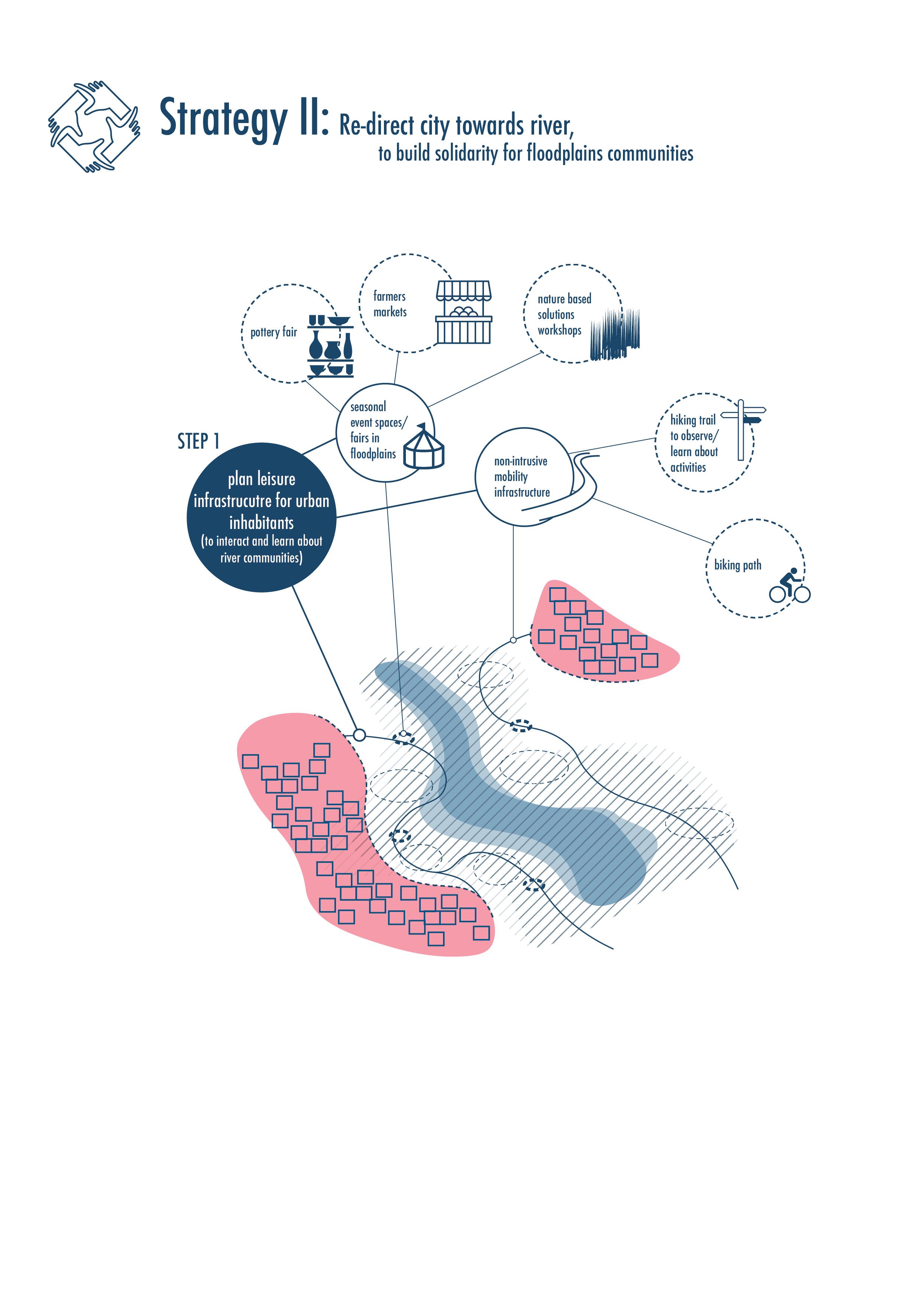
135
Fig. 71: Diagram of strategy-II.
Strategy Proposal
Third, economies that work towards creating habitats for different species on their leased property should be rewarded through means such as lower lease prices. Future maintenance and habitat preservation should be secured in the long term through mile-stone setting in the planning process of floodplains. Examples of such relationships could be bird sanctuaries within designated regions of bamboo farms, fish nursing habitats within wetland lotus cultivation sites or
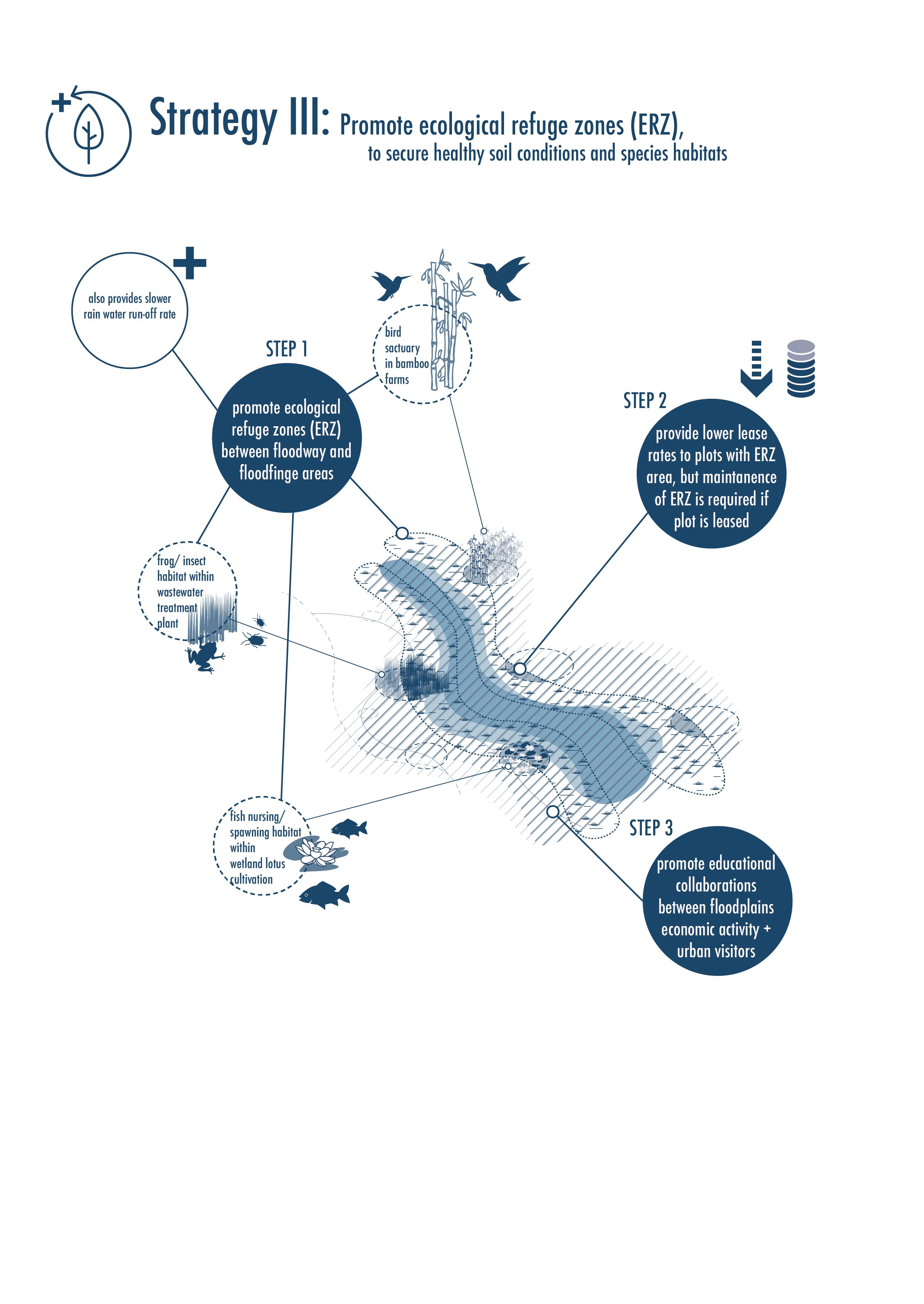
136 Ganges River in the Age of the Anthropocene
Fig. 72: Diagram of strategy-III.
frog and insect sanctuaries within nature based wastewater treatment sites.
Forth, floodplain sites should be promoted as art and creative sites where concepts of temporal construction and natural building materials are explored through means of pavilion design-build competitions for seasonal events as elaborated in strategy II. Such concepts of temporality could help floodplain societies in the future deal with the constantly changing environments they inhabit and build new lifestyles around the notion as ‘transient living’. Not only would this provide
urban solidarity between inhabitants of cities to floodplain communities as proposed in strategy-II, but also it would get new actors involved in floodplain planning processes such as research and educational institutes, architects, planners, local construction industries as well as artists activists.
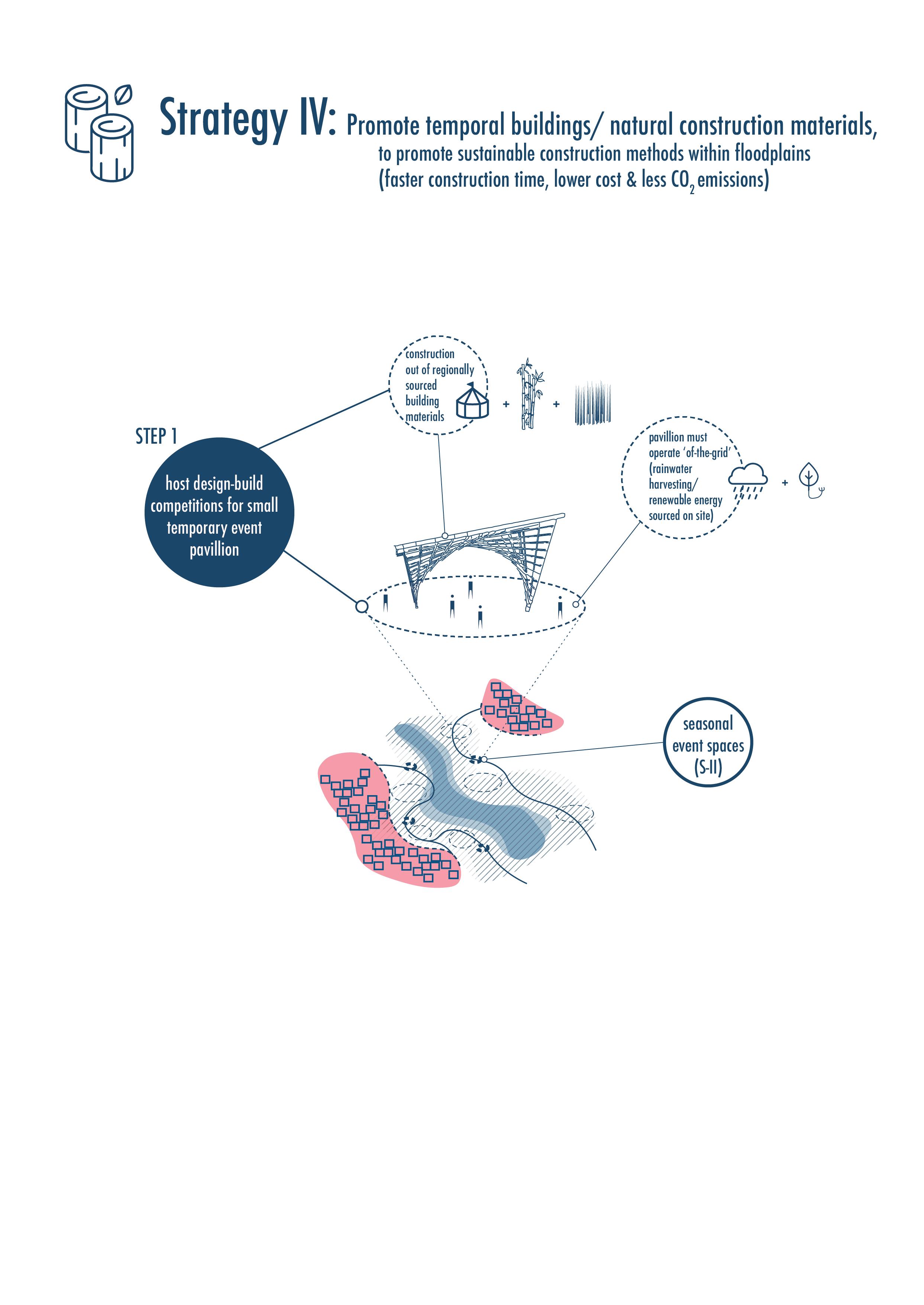
137
Fig. 73: Diagram of strategy-IV.
Strategy Proposal
And lastly, the fifth strategy, is dedicated to building a stronger emergency response mechanism for informal communities that already have settled into floodplain regions today. Displacement and eviction is not a long term solution but rather these settlements must also be surveyed and acknowledged as vulnerable communities. For them emergency evacuation structures such as raised permanent platforms that also act as rain water harvesting tanks can ensure clean water availability
as a first response to flood displacement in the short term. In the longterm, an involvement and participation in floodscape economies should be encouraged to equip informal settlement inhabitants with greater knowledge of water cycles and their productive implementation into daily life and economic benefits.
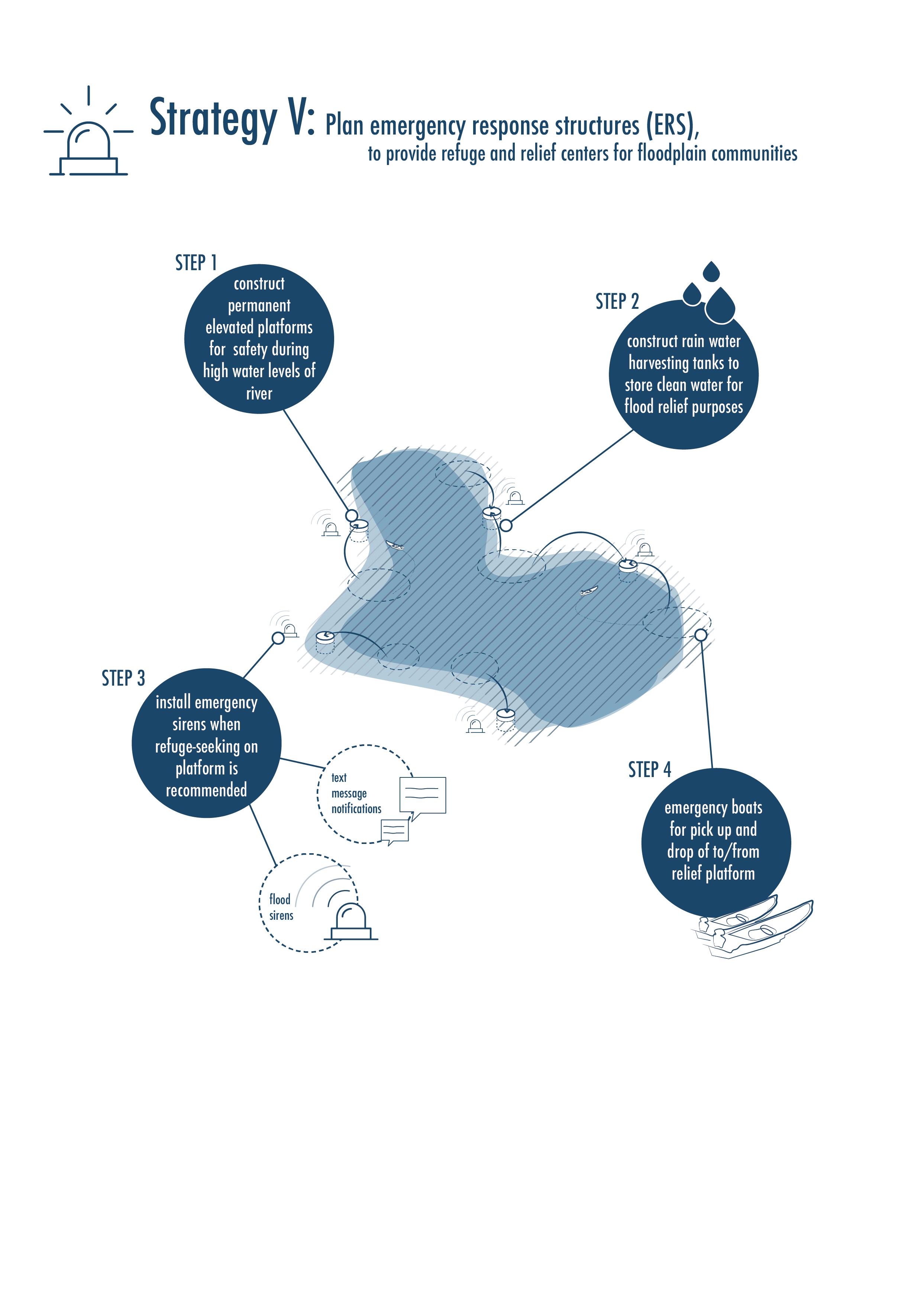
138 Ganges River in the Age of the Anthropocene
Fig. 74: Diagram of strategy-V.
All five strategies bring together a wider range of urban actors into the space making process of democratic floodscapes. Ranging from Environmental Protection Agencies to architects, planners and artists to construction industries and Disaster Management Authorities, and many more. A multi stakeholder collaboration with both a state level Floodplain Management Authority as well as with the Floodscape Communities the strategies offer an opportunity to go beyond a purely economic
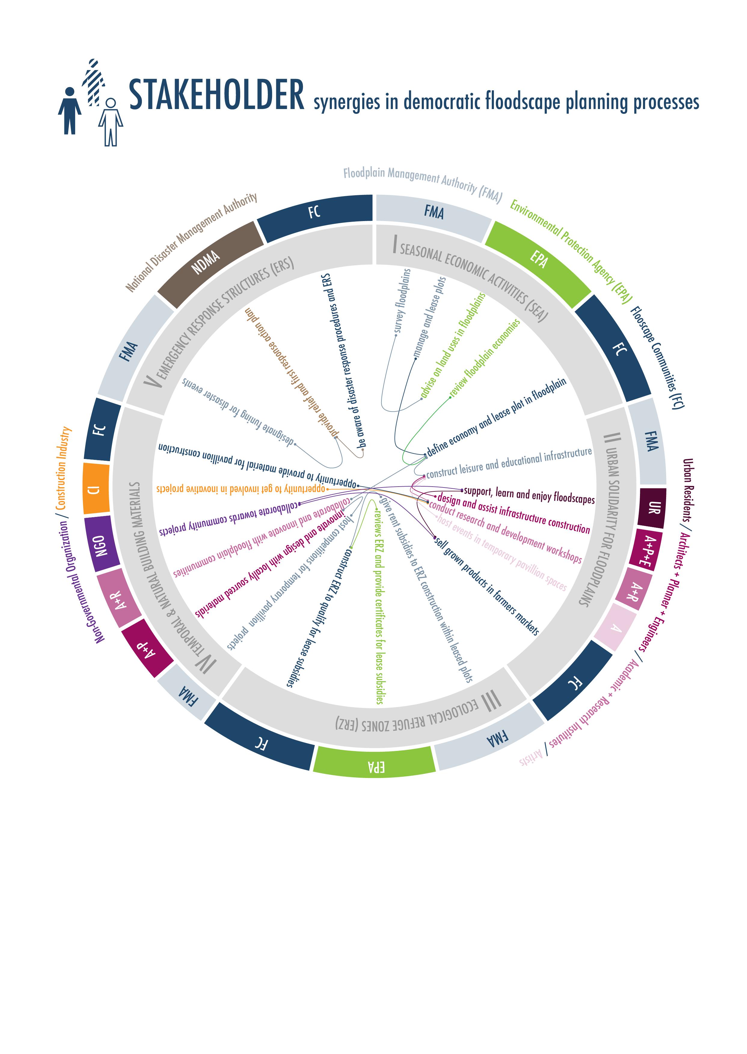
driven landscape construction process but also promote innovation and learning opportunities towards sustainable economies and healthy ecologies for all stakeholders involved. It promotes collaboration for higher water and ecology literacy within the floodscapes.

139
Fig. 75: Diagram of democratic floodscape stakeholder synergies.
Strategy Proposal
RETHINKING FLOODPLAINS OF KANPUR METROPOLITAN AREA
Mathur and Da Cunha (2020) challenge in their work and through their concept of wetness, current processes of mapping rivers, an inherent disconnect of planners and designers to incorporate temporal processes such as the full cycle of water into the design process and a general fading of old traditions and water literacy of cultures and people that is leading to an overall ecological degradation in most areas around the world.
The five proposed strategies towards democratic floodscapes try to tackle exactly these challenges. By applying these strategies to the Kanpur Metropolitan Area, a region that is undergoing rapid transformation though pressures of urban growth and formal urban encroachment and ultimately will change the overall spatial image of the floodplain region within the next ten to twenty years.
Through a series of three quick mapping exercises the river topography is re-examined and drawn from the perspective of the river.
Map 1 Floodplain survey of the natural elements with clear demarcation of flood fringe as an indicator of shift in territory and authority between urban logics and floodscape logics. (Fig. 76)
Map 2 Urban settlements within and outside the floodplain bluff line are delineated to understand the current trend of urban growth into the rivers floodplains by KMA, providing a status quo of the year 2022. (Fig. 77)
Map 3 Potential actor synergy scenarios are staged within the floodplains guided by the five strategies of democratic floodscapes in order to provide an alternative glimpse of future floodplain conditions in the region. (Fig. 78)
Following the three mapping exercises, four potential stakeholder synergies are elaborated through short narratives, explaining possible actors who could get involved, the possible resource recycling cycles that could be built and the types of floodscape spaces which could be created. (Fig. 79 - 82)
140 Ganges River in the Age of the Anthropocene
Lastly, a quick diagrammatic Floodscape Model in 3D shows the logics of planning and space making with floodplain elevations as an alternative mode to engineered landscapes. Organized along five major economy sectors, all potential floodscape economies are set to work with the soils natural water content levels, with lowest elevation land-uses defined for wetlands economies and the highest elevation land-uses defined for urban resource recycling such as sewage water and trash. Implementing such strategies could allow the Floodplain communities to build a stronger identity for themselves, and while also building a stronger link to urban sites, they also become a stronger independent identity and avoid being continued dumbing grounds of the cities. (Fig. 83)
As India already has an authority for a basin wide river management under the National Ganga River Basin Authority, it still awaits for each state to propose floodplain management strategies. Democratic Floodscape strategies could be one such approach to state initiated oversight and management authority for river floodplains. It proposes a Floodplain Management Authority (FMA) for each state that would provide oversight as well as opportunities for new stakeholder synergies, providing not only a legal framework under which current floodplain communities can continue practicing their seasonal economic activities while also having access to state funding for infrastructure and disaster relief but also provide a legal framework within which new stakeholders, especially from urban regions (educational and research institutions, architects, artists, etc) could get involved in active and sustainable floodscape planning processes.
And lastly, the strategies offer no position to the hard infrastrucuture projects such as dams, barrages and canals, as these are infrastrucutures the indian economy is too tightly knit together with, but what it does allow is for the communties within floodplains to empower themselves and build environments that provide care through a continued source of fertile soil and refuge from drastic weather events and momentary river swellings as planning and space making process with water should also provide them with tools and knowledge to live with water in both dry as well as wet seasons.
141 Strategy Proposal
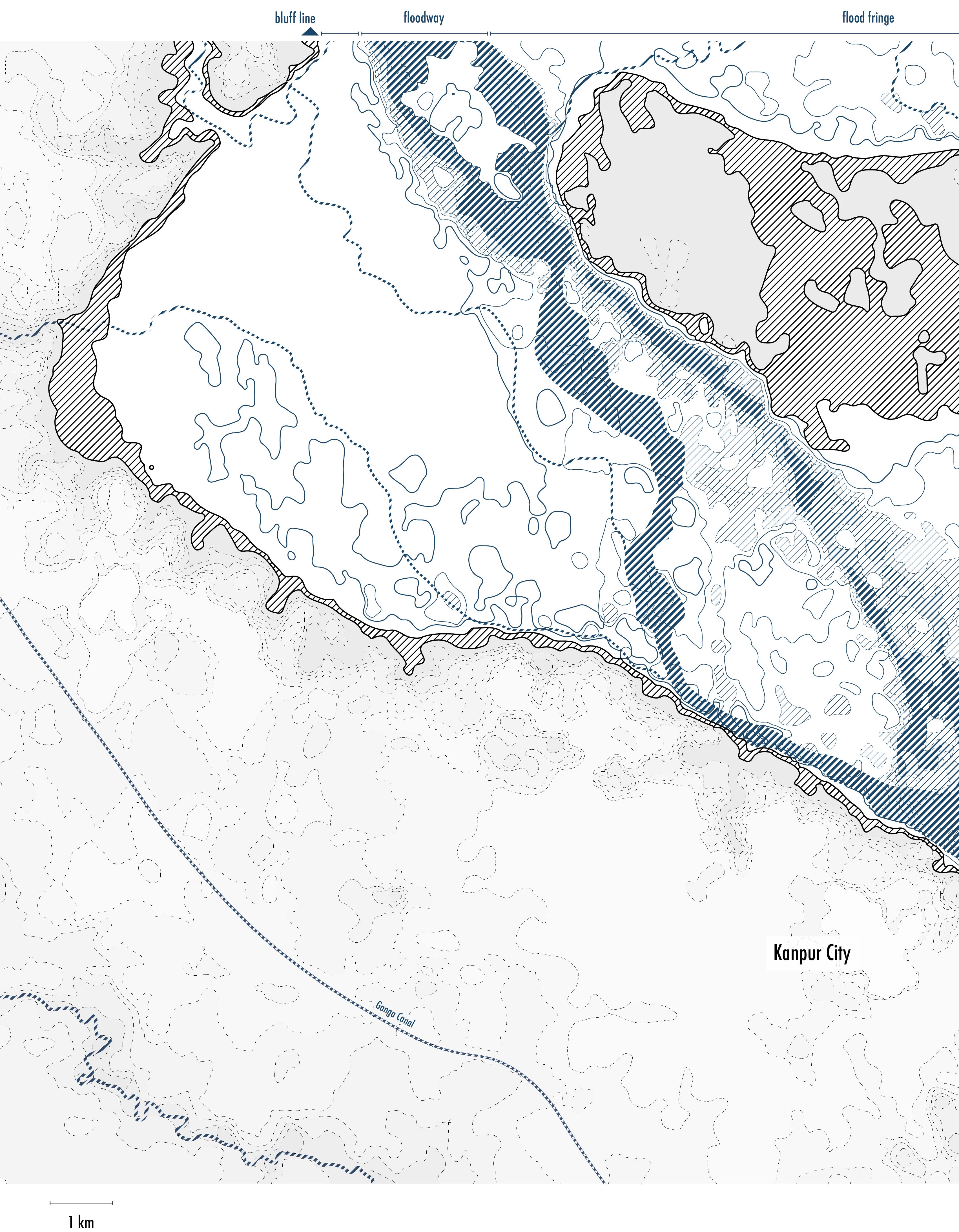
142 Ganges River in the Age of the Anthropocene
GANGES RIVER SURVEY MAP BY KANPUR CITY (NATURAL ELEMENTS)
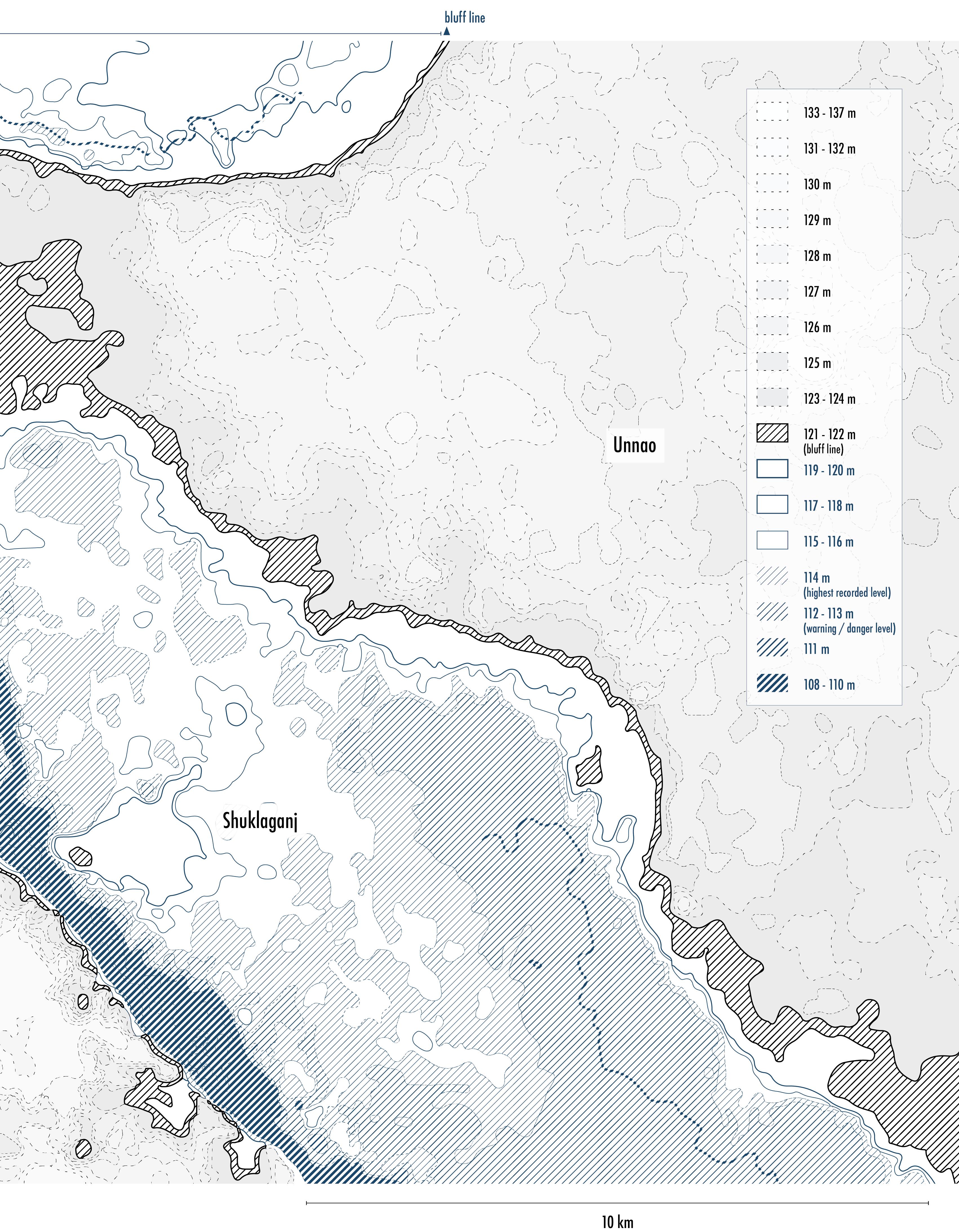
143 Strategy Proposal
Fig. 76: Map 1 - Proposed method for drawing floodplain survey maps, showing the natural elements of water and topography.
GANGES RIVER SURVEY MAP BY KANPUR CITY (URBAN SETTLEMENTS IN 2022)
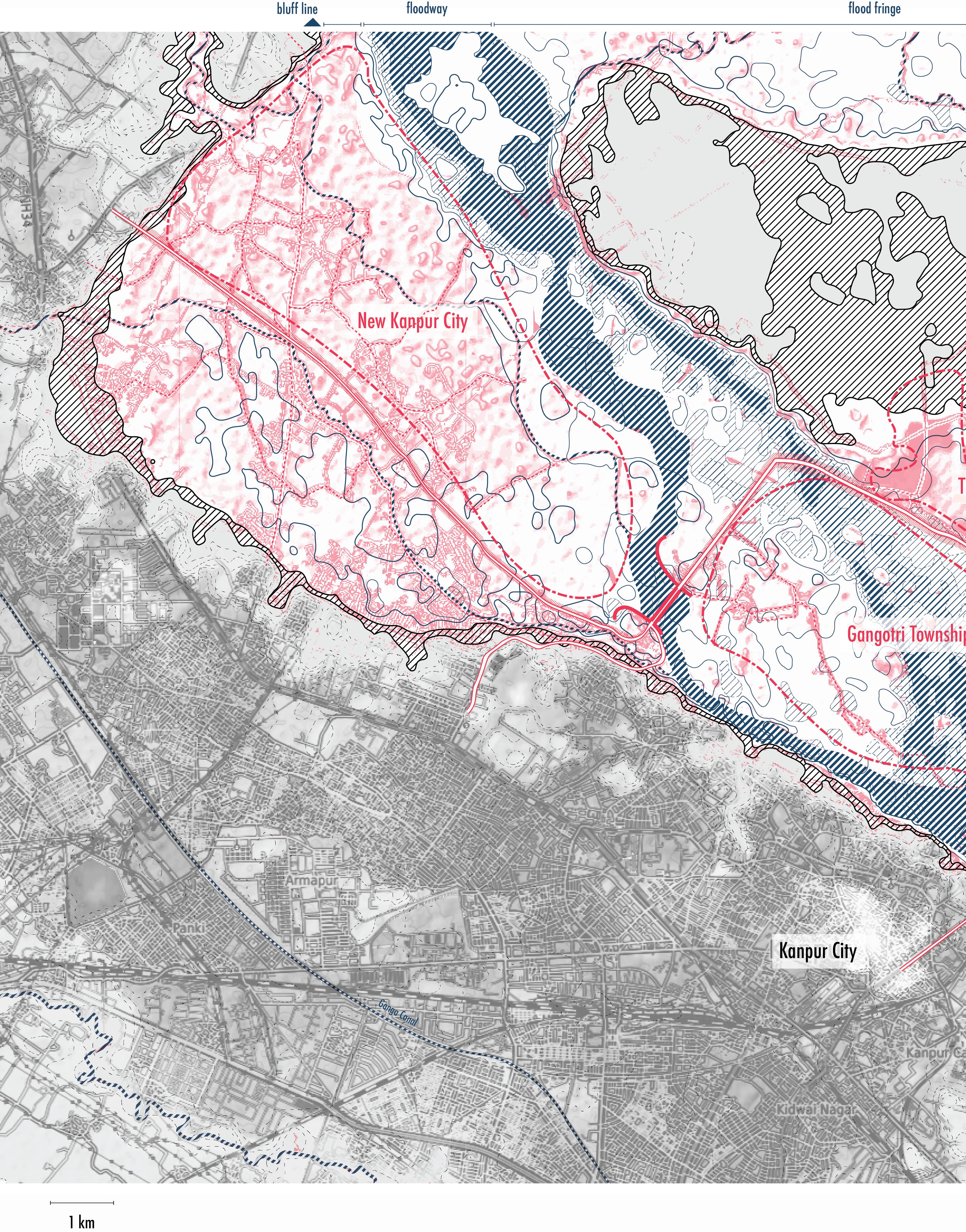
144 Ganges River in the Age of the Anthropocene
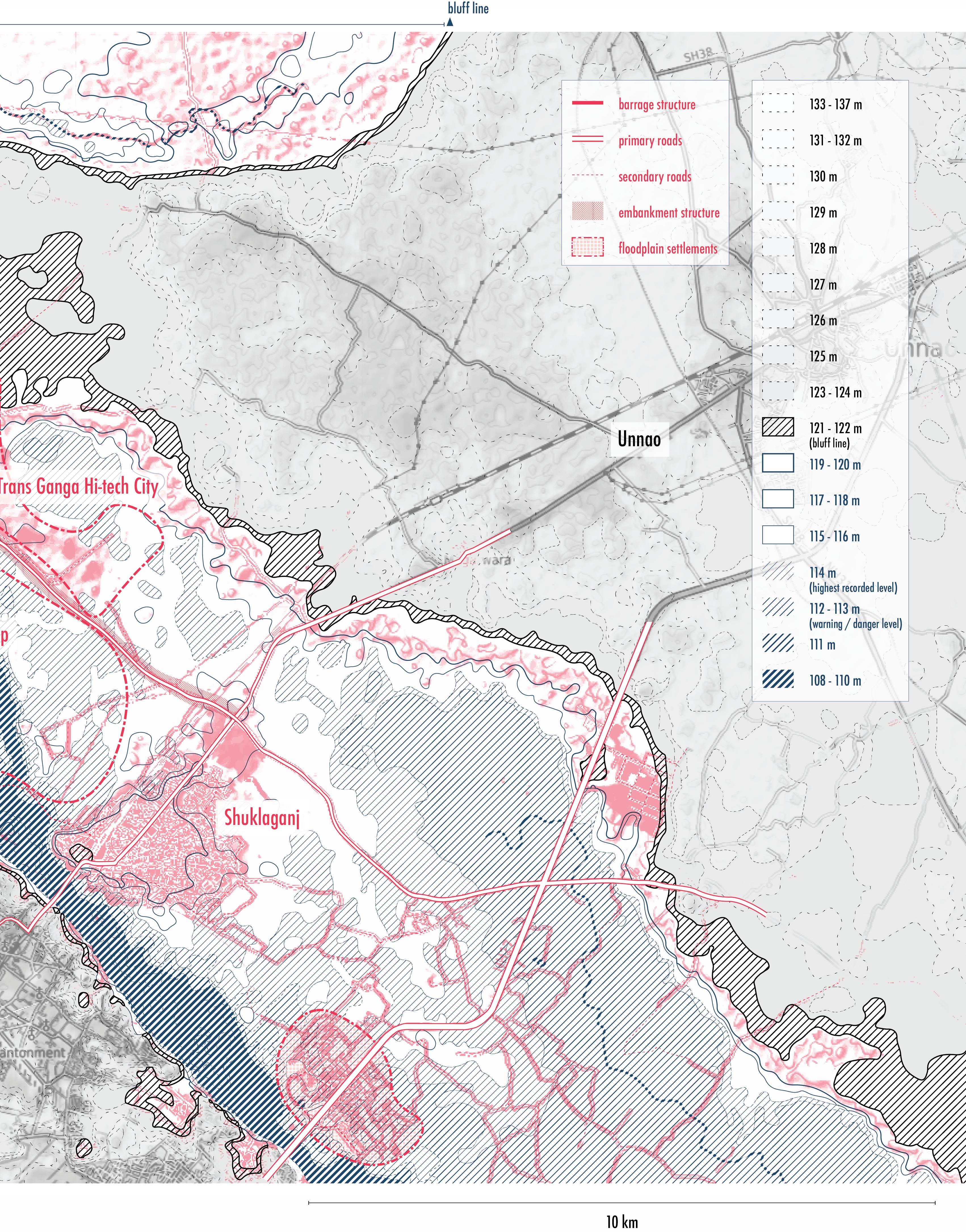
145 Strategy Proposal
Fig. 77: Map 2 - Floodplain survey map showing current settlements within and outside the bluff line.
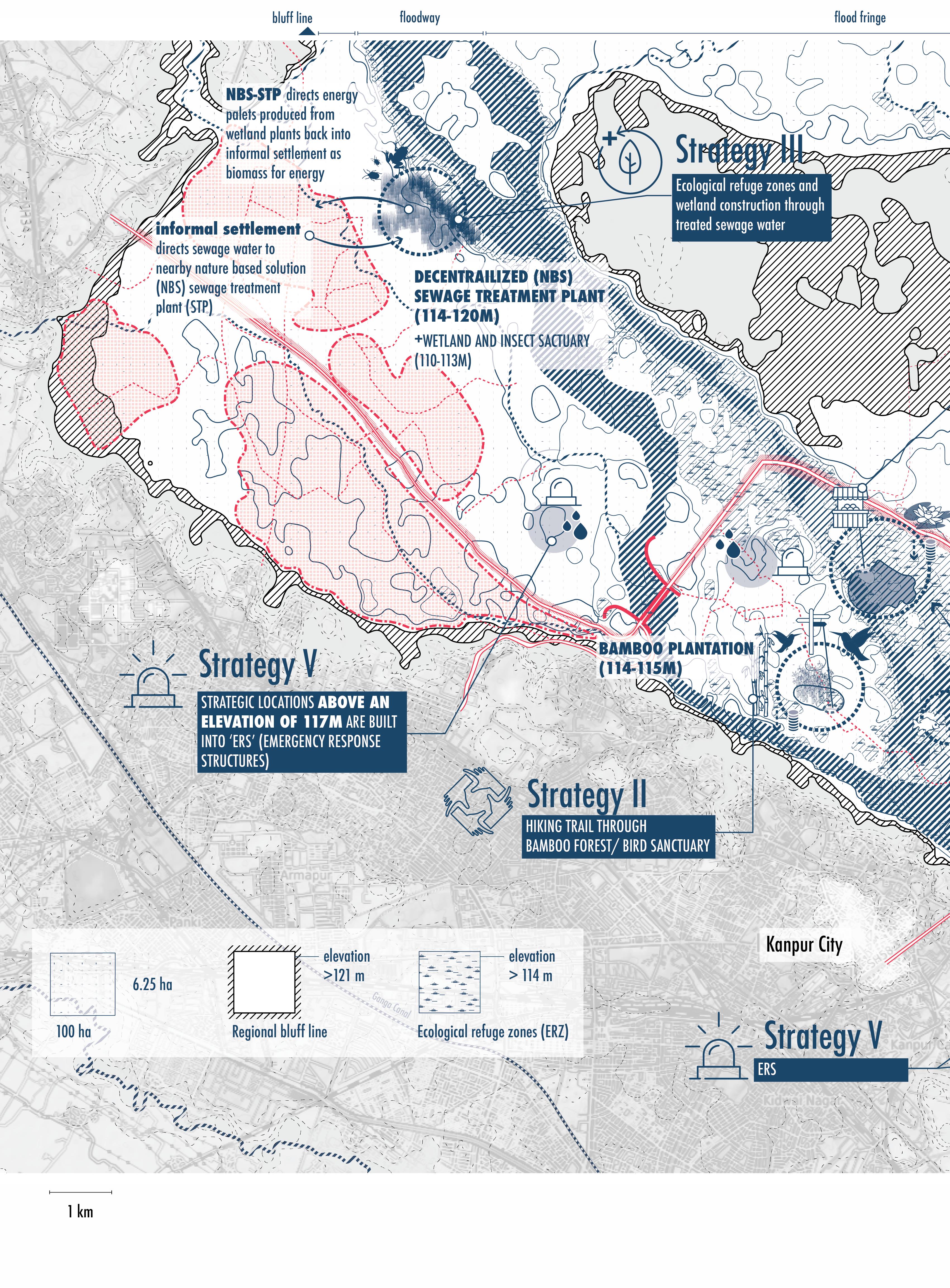
146 Ganges River in the Age of the Anthropocene
GANGES RIVER SURVEY MAP BY KANPUR CITY (DEMOCRATIC FLOODSCAPE PLANNING STRATEGIES)
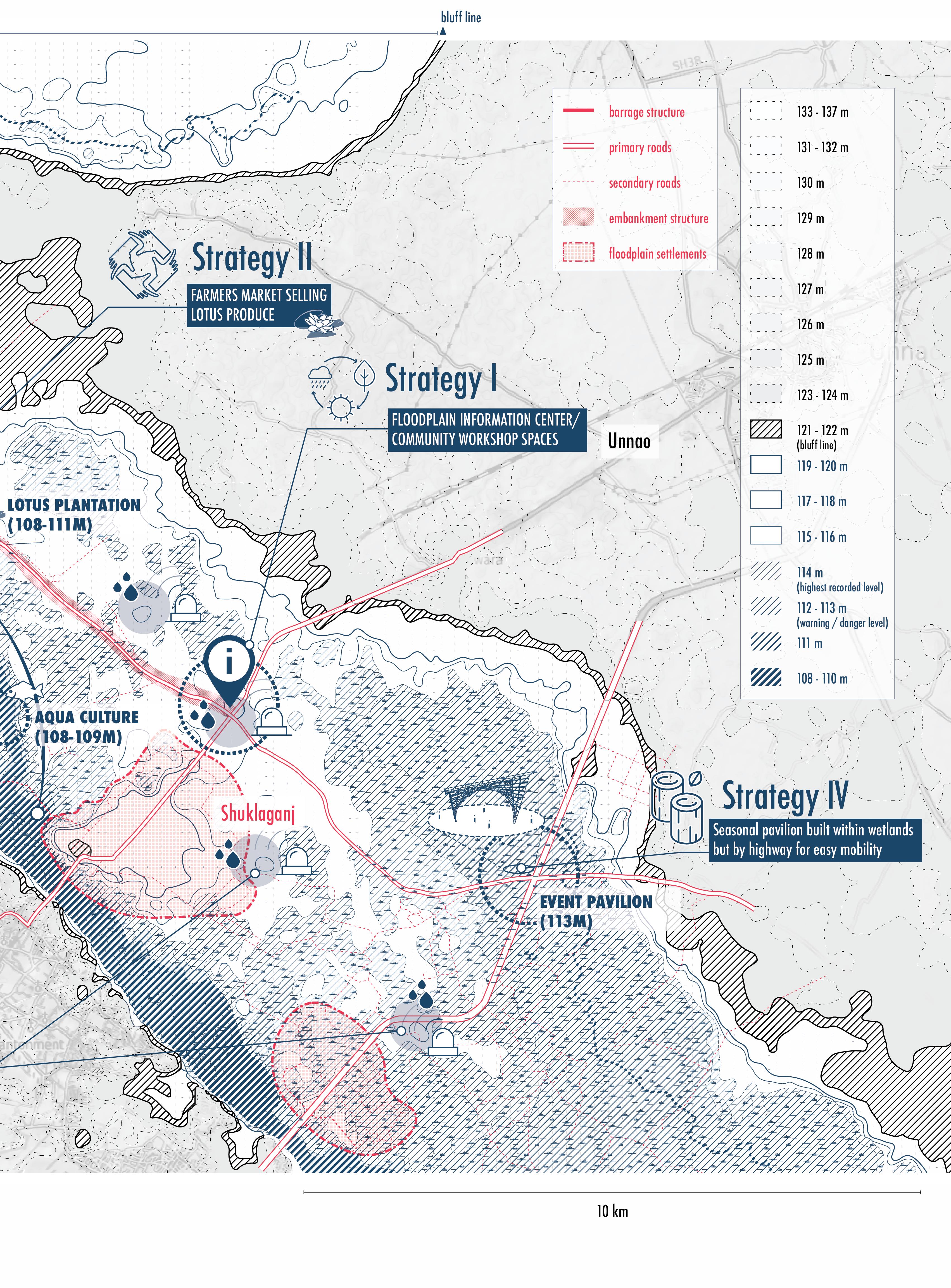
147 Strategy Proposal
Fig. 78: Map 3 - Floodplain survey map showing potential stakeholder synergies through democratic floodscape planning strategies.
Scenario A, shows how a possible cooperation between a new Nature Based Solution (NBS) system such as the one developed by the Indian Counsil for Agricultural Research (ICAR) (Kaur, 2020) (see Case Study II, page 170 in Appendix) presents the informal settlement communities in the floodplain region the opportunity to access a decentralized wastewater treatment facility. In turn, the NBS system is able to make profits from the cultivation of wetland plants from which energy pallets
and construction material can be made. At the same time, the owner of the NBS facility could opt for also nurturing part of it’s facility area as a protected wetland for which he would pay a lower lease rate on the floodplain lands as well as create living habitats for various frogs, birds and insect species.
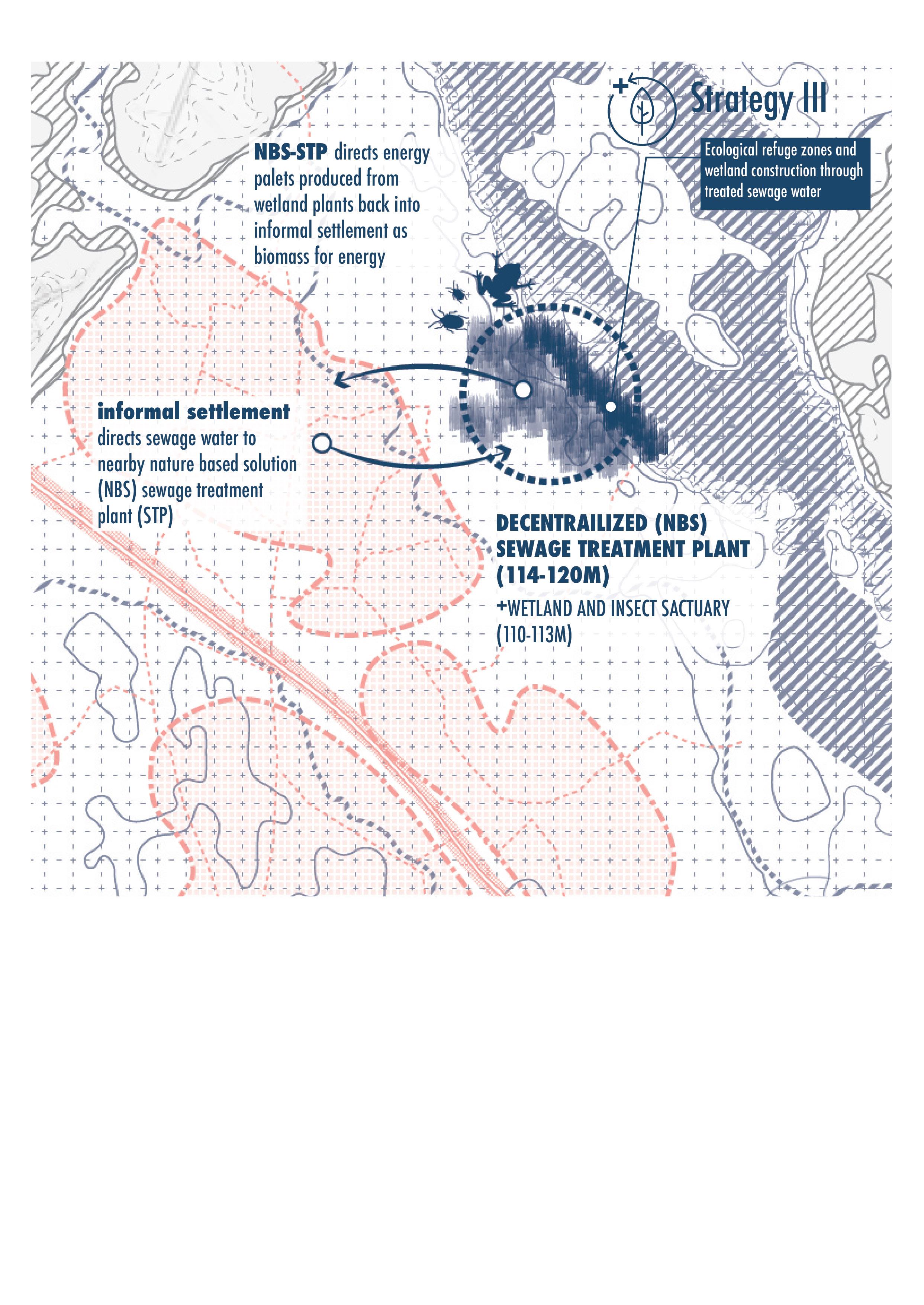
148 Ganges River in the Age of the Anthropocene
Fig. 79: Map 3 - stakeholder synergy scenario A.
Scenario B, shows how a possible new bamboo plantation economy could reserve parts of it’s plantation area as a protected bamboo forest that could act as a bird sanctuary and provide living habitat for birds while also attracting visitors from nearby urban areas who are curious about the potentials of a bamboo economy as well as want to walk through a hiking trail that could be build through a bamboo bird sanctuary. Additionally, the bamboo could be sold regionally to small
vendors within floodplains who would like to set up small kiosks to sell their produce, or other products they grow and produce within the floodplains.
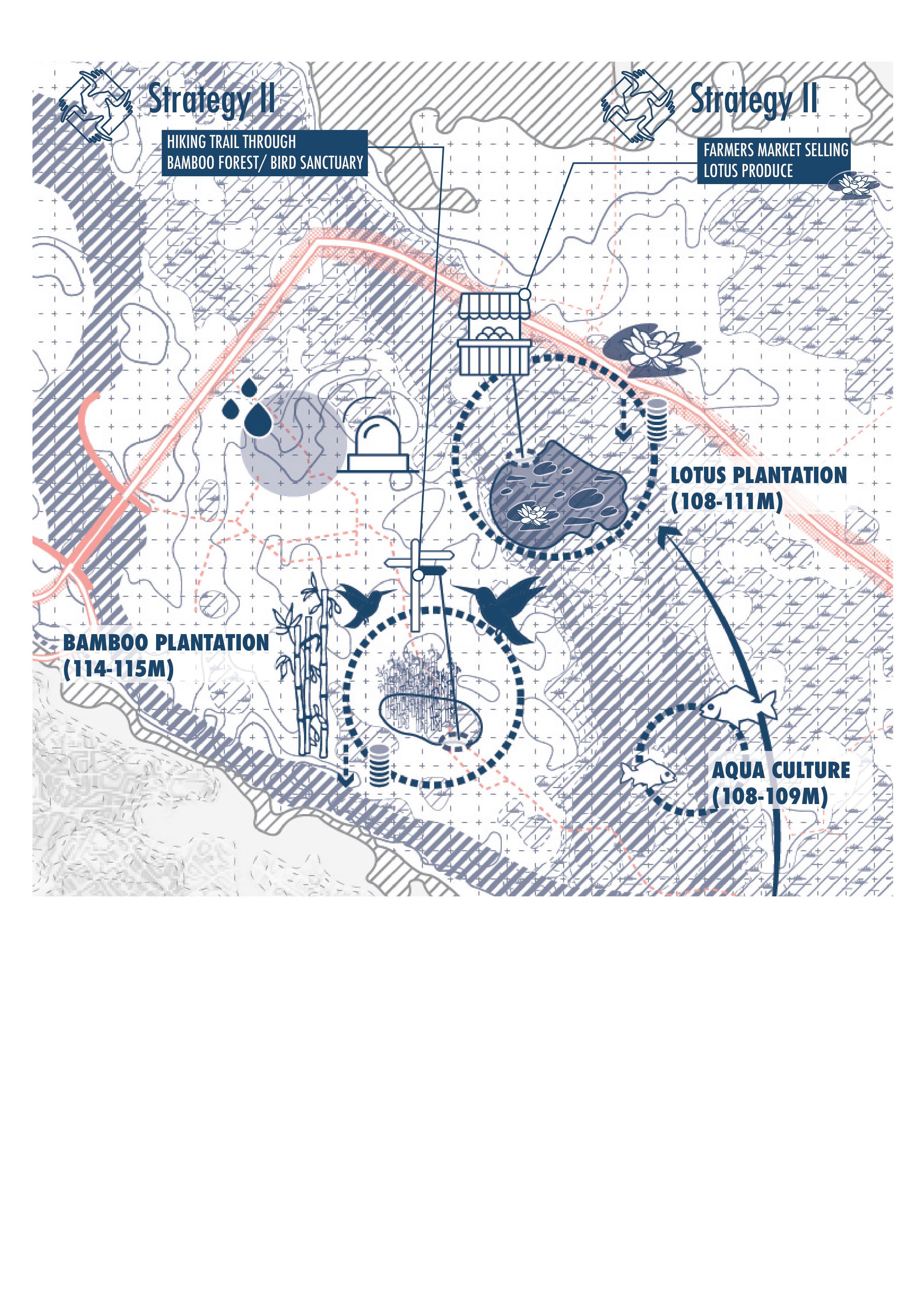
149
Fig. 80: Map 3 - stakeholder synergy scenario B.
Strategy Proposal
Scenario C, hows how a an already existing highway through the floodplain could be incorporated into a strategic location for an Information Center/ Community Workshop space where various educational and research institutes can exchange ideas and knowledge about what current methods and models of seasonal floodplain activities exist and which future models are currently in research and development phase, attracting even a possible new settler who is interested in leasing and operating
a small economy within the floodplain region and has come by the Information Center for more information about available opportunities. Similarly, the close proximity to a highway allows urban actors to access such workshop areas quick and conveniently. Lastly, the high elevation of land next to the highway could also be built simultaneously as an emergency response location where nearby floodplain inhabitants could gather during high water levels of the river.
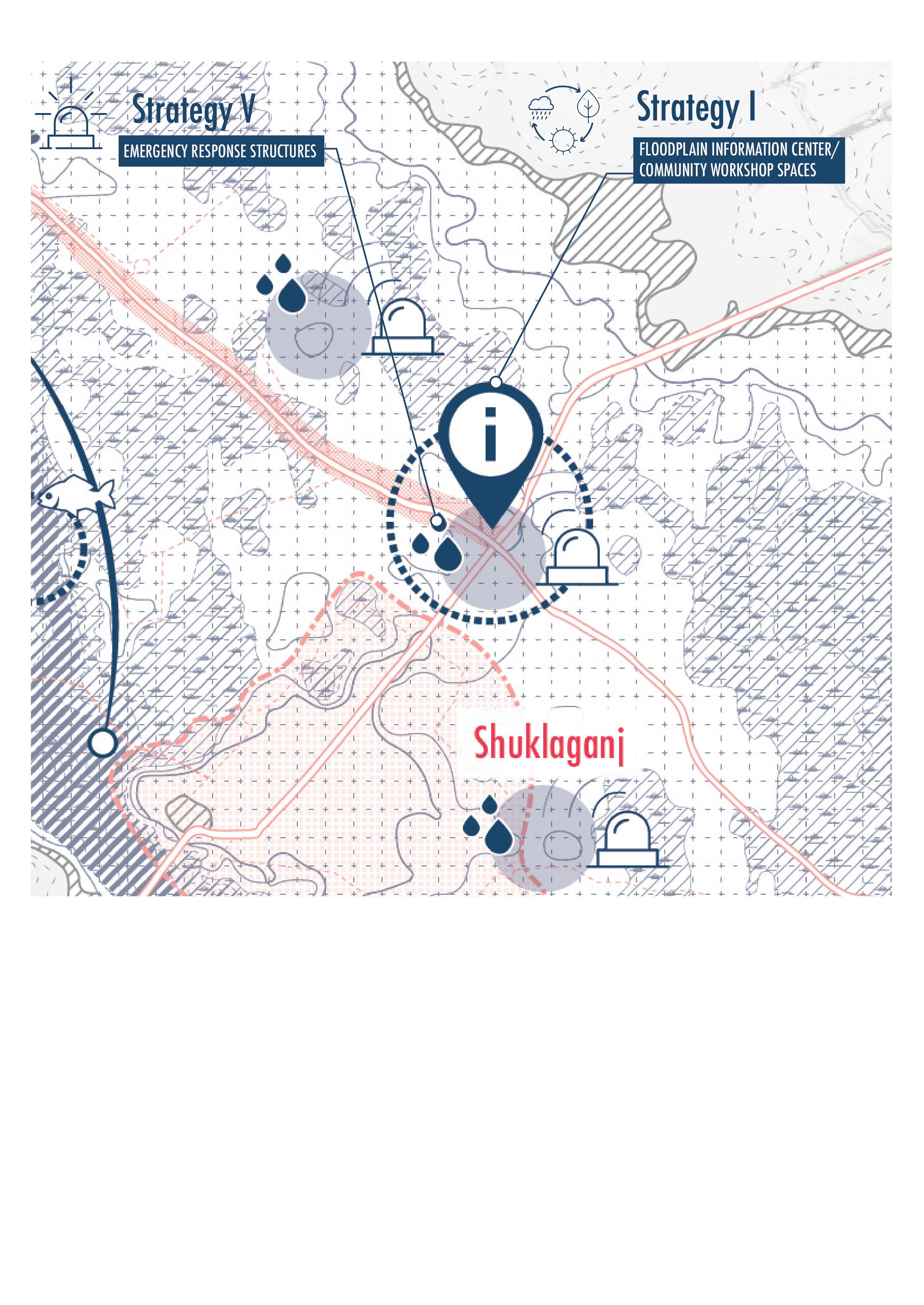
150 Ganges River in the Age of the Anthropocene
Fig. 81: Map 3 - stakeholder synergy scenario C.
Scenario D, shows how another strategic location next to a high speed mobility network could be a good spot for a temporary event space pavilion, which could be designed through an open competition process and thereby attract the participation of local designers and architects. The funding for the construction could be sourced through educational institutes and NGOs while regional construction materials from wetlands and bamboo forests could raise awareness for
such materials and economies, while designers constantly test new possibilities of such materials. All the while, the pavilion could be built on stilts within protected wetlands, giving also urban dwellers the opportunity to experience usually less accessible landscapes within the floodplains.
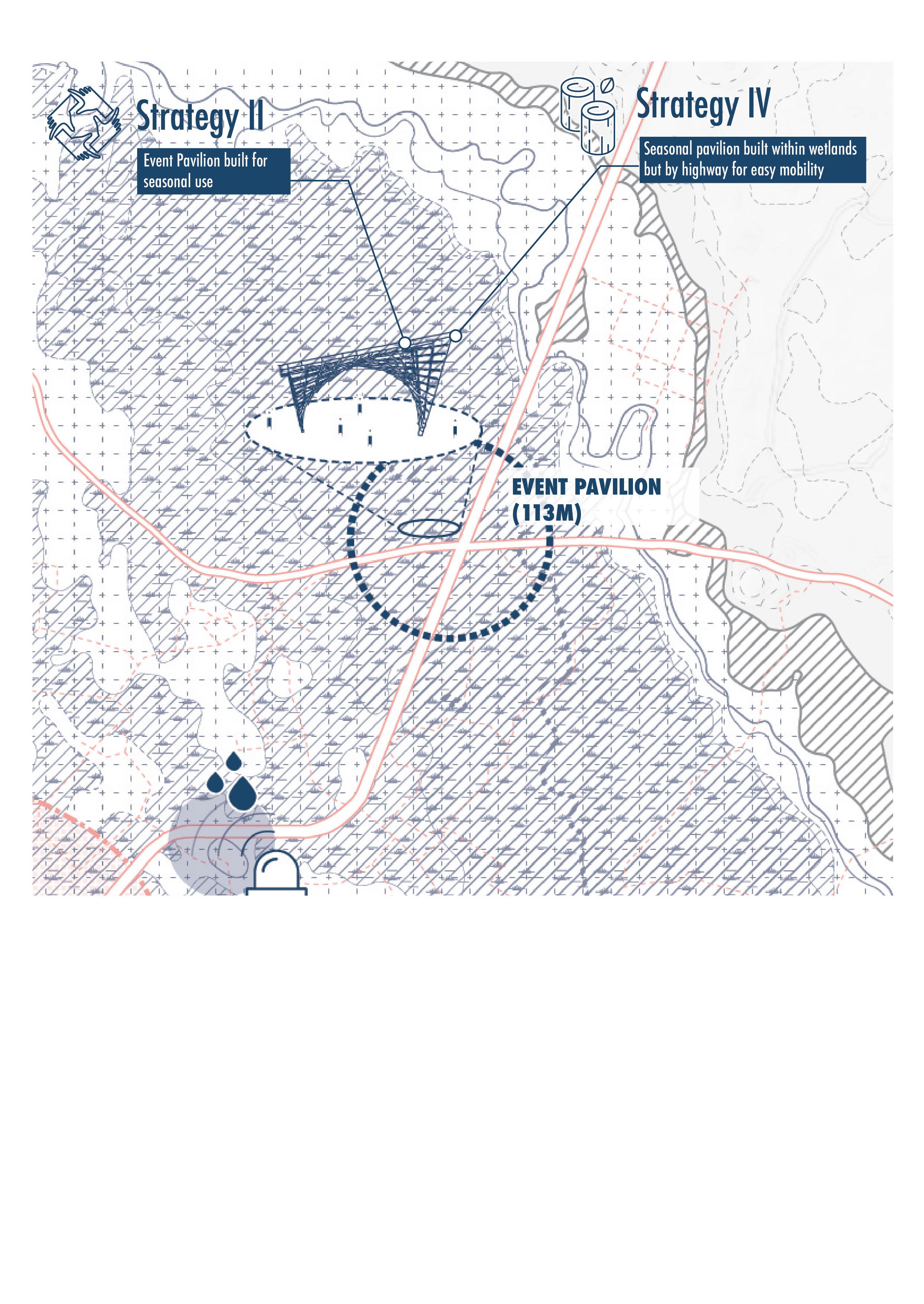
151 Strategy Proposal
Fig. 82: Map 3 - stakeholder synergy scenario D.
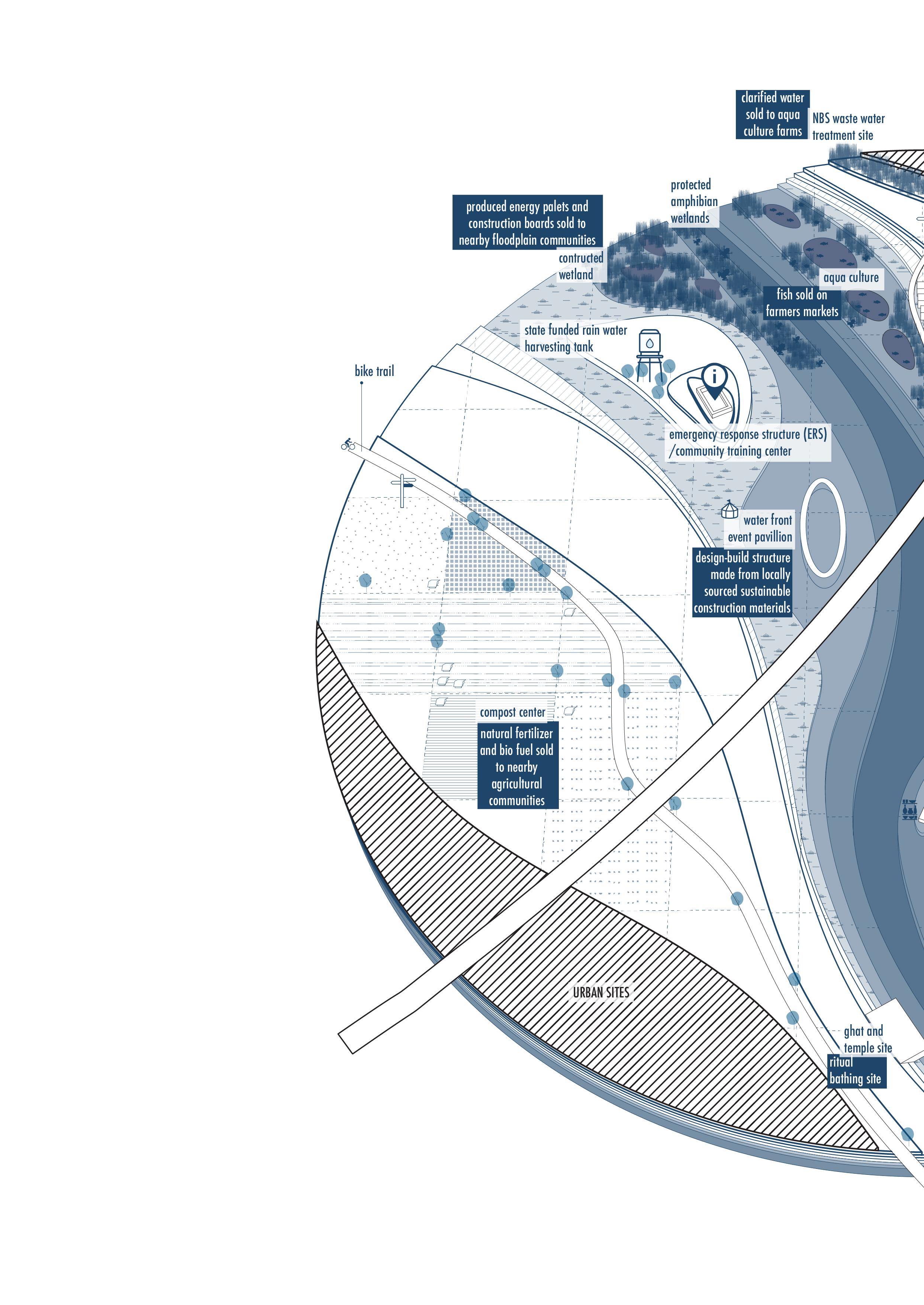
152
River in the Age of the
Fig. 83: Actors and activities organized by floodplain elevations based on logics of Democratic Floodscapes.
Ganges
Anthropocene
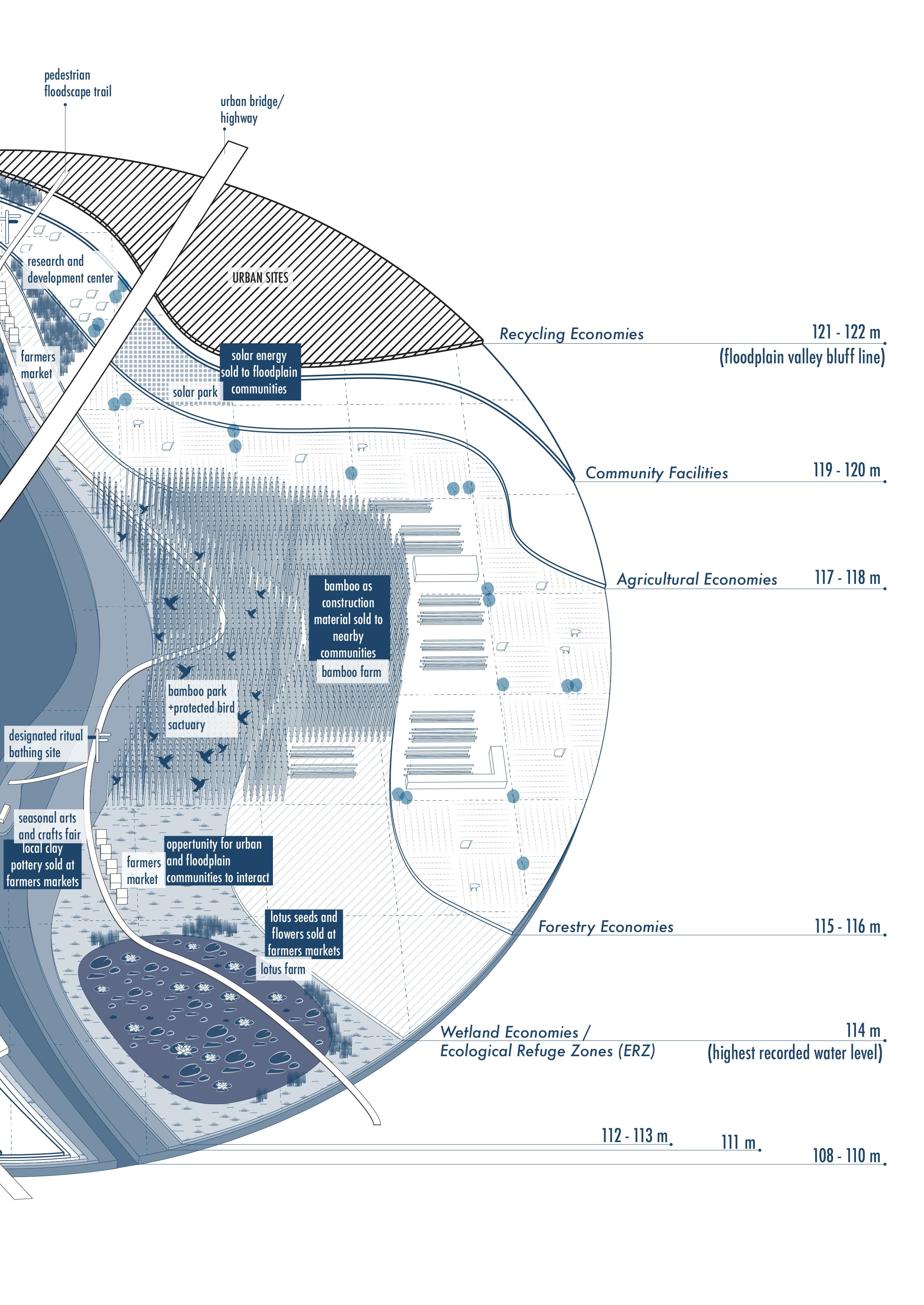
153 Strategy Proposal
154 Ganges River in the Age of the Anthropocene
FUTURE OUTLOOK
155
LESSONS LEARNED FROM BEING WITHIN FLOODPLAINS AND AROUND WETNESS...
Looking back on the initial questions I wanted to answer in my thesis, I believe the process has been very insightful, exploratory and most of all, indeed a sort of reawakening to rivers from a less naive perspective but with a hopeful outlook into the future.
1. How has politics, as a form of influence over spatial design by powerful actors, led to certain transformations of floodplains in the Ganges River Basin over time?
Mainly it has lead to restriction and diminishing of the whole concept of floodplains as such landscapes embody a sense of uncertainty and thus also restrict economic growth potential of the region.
2. What is the impact of inhabitants living in floodplains on the river and on each other?
Urban settlements have the strongest impact on floodplains through a form of strategic and formal encroachment, while those communities that rely on the natural state of the floodplains are displaced as their habitats or converted into urban settlements. Furthermore, the construction of river infrastructure creates inequality in access of fresh water as those who can afford to live in regions supplied by a central water network can enjoy the benefits of river infrastructure that is calibrated to their needs while other inhabitants who have no access to centrally supplied water suffer the bias consequences of river and water calibration by river infrastructure.
3. How are engineered landscapes straining the natural water cycle locally and translocally?
By altering the water cycle, engineered landscapes create a strong dependency of rural sites that lack river infrastructure to urban sites and authorities that are in charge and in control of them. Through the use of river infrastructure like embankments and barrages, urban sites can hold back the water to meet their own demands, while neglecting the same water demands in rural sites. Similarly, urban sites contribute significantly to both an increased rainwater runoff rate through densely built structures and sealed surfaces within the floodplains, thereby also increasing the overall tub-effect of the floodplains. All this leads to a disrupted natural water cycle which makes flash floods and momentary river swellings that much more intense.
4. And lastly, what challenges do we face today in better planning floodplains and creating security for the millions of people that inhabit these floodplains?
Currently, the ambiguity around land-use and unclear land ownership models create a gray zone where powerful stakeholders like developers can exploit the situation by acquiring
156 Ganges River in the Age of the Anthropocene
construction authorization within floodplains that less powerful individuals would not be able to get for the same plot of land in floodplains. Surveying and mapping floodplains is a crucial first step towards having an accessible resource that all stakeholders can review and be held accountable for when encroaching, both formally and informally. Currently no such document exists or is published by the state authorities in India.
To conclude this thesis research and proposal, there are a few main lessons I can take away from my research.
First, just like every story told comes with selected versions of the truth, the same holds true for maps and cartography. Most maps in current consumption represent the interests of humans, while very few represent the interests of rivers and it’s adjacent lying floodplains and ecologies. Yet, a river and it’s ecologies health is also in our interest, as they fulfill crucial ecosystem services of both replenishing groundwater and storing carbon, two factors that climate change has revealed, must find a new voice within planning.
Second, we are just slowly starting to build a new sensitivity towards water as we realize that fresh water scarcity will be one of the defining resources on which the survival and power dynamics of future civilizations depends on. Highlighting the importance of building a sustainable relationships to water could define all forms of urban living as well as define the powerful economies in the future. In this narrative, rivers are the biggest fresh water resource most countries have access to today, making floodplains the biggest asset to plan and manage and secure for the future.
Third, our lives are enriched by the cultures and traditions we follow and experience. As water becomes a scarcity, it is that much more important that we preserve the traditions that we have build with it and around it, in order to also maintain the essence of life itself.
157
Future Outlook
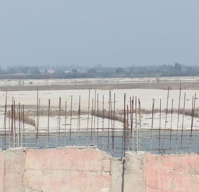
158 Ganges River in the Age of the Anthropocene
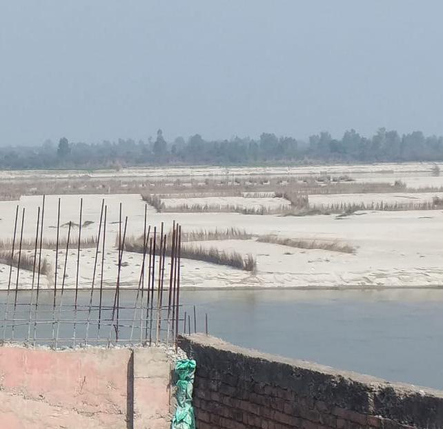
I
159
Looking over the Ganges riverbed and floodplains from an unfinished informal settlement building at the edge of Kanpur City.
APPENDIX
List of References
Acciavatti, A. and Mehrotra, R. (2015) Ganges Water Machine: Designing New India’s Ancient River. Applied Research + Design Publishing.
Aggarwal, M. (2013) Expansion and Commercialization of Agriculture during British Rule, History Discussion - Discuss Anything About History, 23 September. Available at: https://www.historydiscussion.net/ british-india/expansion-and-commercialization-of-agriculture-during-the-british-rule-in-india/640 (Accessed: 27 August 2022).
Agricultural land sq. km - India (no date) The World Bank | Data. Available at: https://data.worldbank.org/ indicator/AG.LND.AGRI.K2?locations=IN (Accessed: 1 September 2022).
Bassi, N., Suresh Babu, S.V. and Kumar, M.D. (2019) Chapter 9 - Water accounting for Kanpur metropolitan area in Ganges river basin, in M.D. Kumar, V.R. Reddy, and A.J. James (eds) Current Directions in Water Scarcity Research. Elsevier (From Catchment Management to Managing River Basins), pp. 245–274. Available at: https://doi.org/10.1016/B978-0-12-814851-8.00009-4.
Chetan and Pradhan, A. (2018) The farmers of Yamuna khadar: a manifesto for urban farming, OneIndia. https://www.oneindia.com. Available at: https://www.oneindia.com/india/the-farmers-of-yamuna-khadar-a-manifesto-for-urban-farming-2800212.html (Accessed: 30 August 2022).
Colebrooke, R.H. (1805) Charte vom Laufe des Ganges von Colgong bis Hurrisonker. Available at: https:// www.oldmapsonline.org/map/cuni/1039231 (Accessed: 24 August 2022).
CWC (n.d.) Central Water Commission, Kanpur. Available at: ffs.tamcnhp.com/main/site (Accessed: 10 January 2022)
Datta, A. (2015) New urban utopias of postcolonial India: “Entrepreneurial urbanization” in Dholera smart city, Gujarat, Dialogues in Human Geography, 5(1), pp. 3–22. Available at: https://doi. org/10.1177/2043820614565748.
Deka, P. (2021). A documentary on Life of Farmers in Delhi | Yamuna Chilla Khadar Village | Migrated Farmers of India (In-Depth Stories). Available at: https://www.youtube.com/watch?v=FU80C2nYSv4 (Accessed: 30 August 2022).
Developers, S.B.B. (no date) Almora. Available at: https://digital.staatsbibliothek-berlin.de/werkansicht?PPN=PPN668657294&PHYSID=PHYS_0299&view=fulltext-endless (Accessed: 27 August 2022).
Dhar, O.N. and Nandargi, S. (2003) Hydrometeorological Aspects of Floods in India, Natural Hazards, 28(1), pp. 1–33. Available at: https://doi.org/10.1023/A:1021199714487.
Did India Need the Green Revolution? (2021). Unscripted. Available at: https://www.youtube.com/ watch?v=qF2xDkphqlY (Accessed: 1 September 2022).
Dixit, A. (2003) Floods and Vulnerability: Need to Rethink Flood Management, Natural Hazards, 28(1), pp. 155–179. Available at: https://doi.org/10.1023/A:1021134218121.
160 Ganges River in the Age of the Anthropocene
Doctor, V. (2020) Recollecting India’s frantic efforts to end starvation after independence, The Economic Times, 26 January. Available at: https://economictimes.indiatimes.com/news/politics-and-nation/recollecting-indias-frantic-efforts-to-end-starvation-after-independence/articleshow/73618277.cms (Accessed: 27 August 2022).
Etheredge, L. (n.d.) Hapi, Egyptian god of the inundation, Britannica. Available at: https://www.britannica. com/topic/Hapi (Accessed: 14 June 2022).
Evers, J. (2022) Floodplain, National Geographic. Available at: https://education.nationalgeographic.org/ resource/flood-plain (Accessed: 30 August 2022).
Gandy, M. (2004) Rethinking urban metabolism: water, space and the modern city, City, 8(3), p. 363. Gandy, M. (2015) From urban ecology to ecological urbanism: an ambiguous trajectory, Area, 47(2), pp. 150–154. Available at: https://doi.org/10.1111/area.12162.
Ganga Basin (n.d.) National Mission for Clean Ganga. Available at: https://nmcg.nic.in/location.aspx (Accessed: 31 August 2022).
Greiner, C. and Sakdapolrak, P. (2013) Translocality: Concepts, Applications and Emerging Research Perspectives, Geography Compass, 7(5), pp. 373–384. Available at: https://doi.org/10.1111/gec3.12048.
Gupta, R. (2005) Barrage of sewage, DownToEarth. Available at: https://www.downtoearth.org.in/news/barrage-of-sewage-9726 (Accessed: 27 August 2022).
Hinshaw, S. and Wohl, E. (2021) Quantitatively Estimating Carbon Sequestration Potential in Soil and Large Wood in the Context of River Restoration, Frontiers in Earth Science, 9. Available at: https://www. frontiersin.org/articles/10.3389/feart.2021.708895 (Accessed: 28 August 2022).
Hofste, R.W., Reig, P. and Schleifer, L. (2019) 17 Countries, Home to One-Quarter of the World’s Population, Face Extremely High Water Stress, World Resource Institute. Available at: https://www.wri. org/insights/17-countries-home-one-quarter-worlds-population-face-extremely-high-water-stress (Accessed: 16 May 2022).
Kanpur, India Metro Area Population 1950-2022 (no date) MacroTrends. Available at: https://www.macrotrends.net/cities/21296/kanpur/population (Accessed: 20 July 2022).
Kanpur topographic map, elevation, relief (no date) topographic-map.com. Available at: https://en-gb. topographic-map.com/maps/lp3h/Kanpur/ (Accessed: 30 August 2022).
Kaur, R. (2020) Jalopchar - An Eco-friendly Wastewater Treatment Technology, Indian Counsil for Agricultural Research. Available at: https://icar.org.in/content/jalopchar-eco-friendly-wastewater-treatment-technology (Accessed: 14 September 2022).
Khadka, N.S. (2016) India Ganges floods “break previous records”, BBC News, 30 August. Available at: https:// www.bbc.com/news/world-asia-india-37217679 (Accessed: 2 August 2021).
Khan, S. et al. (2018) Flows and sediment dynamics in the Ganga River under present and future climate scenarios, Hydrological Sciences Journal, 63(5), pp. 763–782. Available at: https://doi.org/10.1080/02626 667.2018.1447113.
Latour, B. and Weibel, P. (2020) Critical Zones: The Science and Politics of Landing on Earth. MIT Press. Appendix
161
Lin, G.C.S. and Kao, S.-Y. (2020) Contesting Eco-Urbanism from Below: The Construction of “Zero-Waste Neighborhoods” in Chinese Cities, International Journal of Urban and Regional Research, 44(1), pp. 72–89. Available at: https://doi.org/10.1111/1468-2427.12813.
Major, A. (2020) British Humanitarian Political Economy and Famine in India, 1838–1842, Journal of British Studies, 59(2), pp. 221–244. Available at: https://doi.org/10.1017/jbr.2019.293.
Malhotra, A. (2015a) Low rainfall affects flow of Ganga, The Times of India, 2 October. Available at: https:// timesofindia.indiatimes.com/city/kanpur/low-rainfall-affects-flow-of-ganga/articleshow/49193920. cms (Accessed: 27 June 2022).
Malhotra, A. (2015b) Just 405 mm of rainfall recorded this year, Times of India, Available at: https://timesofindia.indiatimes.com/city/kanpur/just-405-mm-of-rainfall-recorded-this-year/articleshow/49180670. cms (Accessed: 27 June 2022).
Malterre-Barthes, C. (2016) The Toshka Project: Colossal Water Infrastructures, Biopolitics and Territory in Egypt, Architectural Design, 86(4), pp. 98–105. Available at: https://doi.org/10.1002/ad.2074.
Mariya, A. et al. (2019) The pristine nature of river Ganges: its qualitative deterioration and suggestive restoration strategies, Environmental Monitoring and Assessment, 191(9), p. 542. Available at: https://doi. org/10.1007/s10661-019-7625-7.
Mathur, A and Da Cunha, D (2020), Wetness is everywhere; Why do we see water somewhere?, in Latour, B and Weibel, P (eds), Critical Zones: The Science and Politics of Landing on Earth, ZKM Press, Karlsruhe, pp. 192-203.
Maurya, N. and Chowdhury, S.R. (2020) River pollution, conservation: UP’s fishing community bears brunt, Down To Earth. Available at: https://www.downtoearth.org.in/blog/environment/river-pollution-conservation-up-s-fishing-community-bears-brunt-71908 (Accessed: 30 August 2022).
Mike Routledge (tran.) (2018) For a terrestrial politics: An interview with Bruno Latour. Available at: https:// www.eurozine.com/terrestrial-politics-interview-bruno-latour/# (Accessed: 27 August 2022).
Mississippi. An Anthropocene River (2018) Anthropocene Curriculum. Available at: https://www.anthropocene-curriculum.org/project/mississippi (Accessed: 24 August 2022).
Modak, S. and Kapuria, P. (2020) From Policy to Practice: Charting a Path for Floodplain Zoning in India, ORF. Available at: https://www.orfonline.org/research/from-policy-to-practice-charting-a-path-forfloodplain-zoning-in-india-66717/ (Accessed: 30 August 2022).
NMCG (no date), National Mission for Clean Ganga(NMCG),Ministry of Jal Shakti, Department of Water Resources, River Development & Ganga Rejuvenation, Government of India. Available at: https://nmcg.nic. in/ (Accessed: 14 September 2022).
Nelson, A.R.L.E., Ravichandran, K. and Antony, U. (2019) The impact of the Green Revolution on indigenous crops of India, Journal of Ethnic Foods, 6(1), p. 8. Available at: https://doi.org/10.1186/s42779-0190011-9.
Lakshmi, D.K.S. et al. (2017) National Seminar on Rural Infrastructure in India: Issues and Prospects. Allied Publishers.
162 Ganges River in the Age of the Anthropocene
Pradhan, A. (2018) Kheti and Khaddar: Land and rights on a riverine floodplain, Unsettling Place and Space [Preprint]. Available at: https://www.academia.edu/35350128/Kheti_and_Khaddar_Land_and_ rights_on_a_riverine_floodplain (Accessed: 30 August 2022).
Priya, S. et al. (2017) Flood Risk Assessment and Forecasting for the Ganges-Brahmaputra-Meghna River Basins. Technical Paper. Washington, DC: World Bank. Available at: https://doi.org/10.1596/28574.
Ramadas, S., Kumar, T.M.K. and Singh, G.P. (2019) Wheat Production in India: Trends and Prospects, Recent Advances in Grain Crops Research. IntechOpen. Available at: https://doi.org/10.5772/intechopen.86341.
Research Shows More People Living in Floodplains (2021). NASA Earth Observatory. Available at: https:// earthobservatory.nasa.gov/images/148866/research-shows-more-people-living-in-floodplains (Accessed: 24 August 2022).
Revanthukkalam (2019) Demon of Cawnpore, The dialogue, 11 September. Available at: https://prajnanambrahmablog.wordpress.com/2019/09/11/demon-of-cawnpore/ (Accessed: 27 August 2022).
Ritchie, H. and Roser, M. (2013) Crop Yields, Our World in Data [Preprint]. Available at: https://ourworldindata.org/crop-yields (Accessed: 1 July 2022).
River Discharge - an overview | ScienceDirect Topics (no date). Available at: https://www.sciencedirect. com/topics/earth-and-planetary-sciences/river-discharge (Accessed: 24 August 2022).
Rossano, F. (2021) Floodscapes: Contemporary Landscape Strategies in Times of Climate Change. nai010 uitgevers publishers.
Sen, S. (2015) Irrigation Development in India During British Rule, Your Article Library, 26 June. Available at: https://www.yourarticlelibrary.com/irrigation/irrigation-development-in-india-during-british-rule/60643 (Accessed: 27 August 2022).
Sengupta, S. (no date) Iconic city or concrete jungle?, DownToEarth. Available at: https://www.downtoearth. org.in/blog/iconic-city-or-concrete-jungle-47957 (Accessed: 27 August 2022).
Singh, K. (2010) Thousands evacuated from Kanpur as Ganga breaches banks, The Indian Express, 28 September. Available at: https://indianexpress.com/article/cities/lucknow/thousands-evacuated-from-kanpur-as-ganga-breaches-banks/ (Accessed: 24 August 2022).
Sinha, S.K. (2021) The Conservation Saga of the Ganges River Dolphin, Roundglass Sustain. Available at: https://roundglasssustain.com/conservation/ganges-river-dolphin (Accessed: 6 July 2022).
Silk, J. (2022) India: Why are suicides among farmers on the increase?, Deutsche Welle. Available at: https:// www.dw.com/en/india-why-are-suicides-among-farmers-on-the-increase/a-62991022 (Accessed: 15 October 2022).
Tare, V. and Bose, P. (2010) Guidelines for the Preparation of Urban River Management Plan (URMP) for all Class I Towns in Ganga River Basin. National Mission for Clean Ganga. Available at: https://nmcg.nic. in/writereaddata/fileupload/30_2_002_EQP_S&R_01.pdf (Accessed: 15 June 2022).
Tare, V. and Mathur, R.P. (2010) River Ganga at a Glance: Identification of issues and priority actions for restoration. National Mission for Clean Ganga. Available at: https://nmcg.nic.in/writereaddata/fileupload/33_43_001_GEN_DAT_01.pdf (Accessed: 15 June 2022).
163
Appendix
Tellman, B. et al. (2021) Satellite imaging reveals increased proportion of population exposed to floods, Nature, 596(7870), pp. 80–86. Available at: https://doi.org/10.1038/s41586-021-03695-w.
The Project Gutenberg eBook of Cawnpore, by G. O. Trevelyan. (no date). Available at: https://www.gutenberg.org/files/51383/51383-h/51383-h.htm (Accessed: 27 August 2022).
The National Ganga River Basin Project (2015) World Bank. Available at: https://www.worldbank.org/en/ news/feature/2015/03/23/india-the-national-ganga-river-basin-project (Accessed: 14 September 2022).
Wall, D. and Lanigan, G. (2020) Protecting soil carbon stocks and enhancing Carbon Sequestration, Teagasc. Available at: https://www.teagasc.ie/publications/2020/protecting-soil-carbon-stocks-and-enhancing-carbon-sequestration.php (Accessed: 13 September 2022).
Washbrook, D. (1994) The Commercialization of Agriculture in Colonial India: Production, Subsistence and Reproduction in the “Dry South”, c. 1870–1930, Modern Asian Studies, 28(1), pp. 129–164. Available at: https://doi.org/10.1017/S0026749X00011720.
Wheat (2018) Farmers’ Portal. Available at: https://farmer.gov.in/m_cropstaticswheat.aspx (Accessed: 12 May 2022).
Why should we care about floodplains? (no date). European Environment Agency. Available at: https://www. eea.europa.eu/publications/why-should-we-care-about-floodplains (Accessed: 27 August 2022).
Wood, J. (1907) Ganges Canal (Nuttall Encyclopædia). Available at: https://words.fromoldbooks.org/ Wood-NuttallEncyclopaedia/g/gangescanal.html (Accessed: 31 August 2022).
Parl panel hits out at flood-prone states for not enacting model bill for flood plain zoning (no date) The Print –PTIFeed’. Available at: https://theprint.in/india/parl-panel-hits-out-at-flood-prone-states-for-not-enacting-model-bill-for-flood-plain-zoning/1051238/ (Accessed: 27 August 2022).
List of Figures
Introduction
Fig. 1(Cover): Floodplain elevation map. Source: Drawn by author
Fig. 2: Natural water cycle. Source: Drawn by author
Fig. 3: Floodplain terminology sketches. Source: Drawn by author
Fig. 4: Global flood events by type and total population exposed. Source: NASA Earth Observatory (2020)
Fig. 5: Flood event data of Global vs. Asia. Source: Data taken from the NASA Earth Obervatory (2020). Drawn by author
Fig. 6: Major river’s around the world by average discharge volume (solid blue square) vs. maximum discharge volume (hatched blue square). Source: Data based on wikipedia entries for each individual river. Drawn by author
Fig. 7: Map by Colebrooke depicting activities and the process of natural river meandering from Colgong to Hurrisonker (1805). Source: https://maps-prints.com/antique-maps-india-ceylon/9379-antique-map-of-the-
Ganges River in the Age of the Anthropocene
164
ganges-river-by-colebrooke-1805.html
Fig. 8: Map of India with Ganges River Basin region highlighted in light blue. Source: Data from OpenStreetMap (n.d.). Drawn by author
Fig. 9: Diagram of thesis methodology. Source: Drawn by author
Politics of Infrastructure
Fig. 10: Diagram of three stages of disconnect from natural floodplains. Source: Drawn by author
Fig. 11: Image from Jules Verne book ‘The Steam Engine - the Demon of Cawnpore’, 1880: 206. Source: Verne (1880)
Fig. 12: Timeline of British East India Company’s ruling area in India by 1765. Source: Drawn by author
Fig. 13: Timeline of British East India Company’s ruling area in India by 1857. Source: Drawn by author
Fig. 14: Timeline of British East India Company’s ruling area in India by 1947 with major canal network drawn in red. Source: Drawn by author
Fig. 15: Diagrams of river landscape transformations. Source: Drawn by author
Fig. 16: Diagrams of river basin transformation from a natural river network to one governed by a river infrastructure network. Data from OpenStreetMap (n.d.). Drawn by author
Fig. 17: Timeline of main events of the Ganga Canal project during British rule in India. Source: All illustrations sourced from Wikipedia articles, map of India drawn by author.
Fig. 18: Global drivers of agricultural reforms in India till 1960. Source: Data taken from Did India Need the Green Revolution? (2021). Drawn by author
Fig. 19: Global drivers of agricultural reforms in India after 1960. Source: Data taken from Did India Need the Green Revolution? (2021). Drawn by author
Fig. 20: Map of irrigated agriculture (green) vs rain-fed agriculture regions (blue) within GRB. Source: Data from OpenStreetMap (n.d.). Drawn by author
Fig. 21: Impact of industrialized agricultural practices on soil health vs. sustainable farming practices. Source: Drawn by author in collaboration with Senta Hoppe
Fig. 22: Google Earth areial image of Kanpur City region, showing in red the barrage and new highway construction area location. Source: Aerial image captured with Google Earth Pro’s History Tool. Map drawn my author
Fig. 23: erial image and diagram showing river course change of Ganges river along Kanpur City from 1998 till 2010. Source: Aerial image captured with Google Earth Pro’s History Tool, transformation diagrams drawn by author
Fig. 24: DEM model of Kanpur City region, representative water map indicating lowest elevation of the region in darker hues of blue. Source: DEM data from http://viewfinderpanoramas.org/Coverage%20map%20 viewfinderpanoramas_org3.htm. Map drawn my author
165
Appendix
Politics of Land
Fig. 25: Diagram showing location of three floodplain settlement settings within the GRB. Source: Data from OpenStreetMap (n.d.). Drawn by author
Fig. 26: Online news article showing the frustration of the central government as ‘flood prone states’ have failed to implement a floodplain zoning bill nearly 47 years after the first initiation back in 1975. Source: Parl panel hits out at flood-prone states for not enacting model bill for flood plain zoning (no date) The Print.
Fig. 27: Satellite image showing the landscape along the rivers within the GRB. Source: Aerial image captured with Google Earth Pro.
Fig. 28: Bankside A-2: Community of vendors selling religious artifacts, street food and boating trips along the holy Ganges River. Source: Captured by author in Brijghat, UP (February, 2022).
Fig. 29: Bankside B-2: agricultural activities in the month of Febuary. Source: Captured by author in Brijghat, UP (February, 2022).
Fig. 30: Panoramic photo collage, section and satellite image showing site analysis of Brijghat in February, 2022. Source: Aerial image captured with Google Earth Pro’s History Tool, photos captured and drawing by author.
Fig. 31: Bankside B-1 showing rain-fed farming with daikon, cucmber and cabbage crops inside the riverbed. Source: Captured by author in Brijghat, UP (February, 2022).
Fig. 32: Bankside B-1 showing rapeseed harvest within the riverbed, with a raised levee construction separating the infrared farming from irrigated farming beyond the levee structure. Source: Captured by author in Brijghat, UP (February, 2022).
Fig. 33: Panoramic photo collage, section and satellite image showing analysis of Brijghat as expected in the month of June. Source: Aerial image captured with Google Earth Pro’s History Tool from June, 2019, photos captured and drawing by author.
Fig. 34: Panoramic photo collage, section and satellite image showing analysis of Brijghat as expected in the month of October. Source: Aerial image captured with Google Earth Pro’s History Tool from October, 2020, photos captured and drawing by author.
Fig. 35: Bankside A-1 constructed promenade stairs leading down to riverbank. Source: Captured by author in Brijghat, UP (February, 2022).
Fig. 36: Bankside B-1 showing exposed riverbed with both hood structures for religious ceremonies and agricultural activities. Source: Captured by author in Brijghat, UP (February, 2022).
Fig. 37: Bankside A-1 sandbags at riverbank to secure sand from being washed out by river current, along with Hindu priests and devotees taking a bath. Source: Captured by author in Brijghat, UP (February, 2022).
Fig. 38: Bankside B-1 showing agricultural activities in the month of February. Source: Captured by author in Brijghat, UP (February, 2022).
Fig. 39: Bankside B-1 showing agricultural activities in the month of February. Source: Captured by author in
166 Ganges River in the Age of the Anthropocene
Brijghat, UP (February, 2022).
Fig. 40: Bankside B-1 showing floodplain farmer spreading seeds over riverbed. Source: Captured by author in Brijghat, UP (February, 2022).
Fig. 41: Bankside A-2 showing small tents set up for ceremonial rituals and promenade community beyond. Source: Captured by author in Brijghat, UP (February, 2022).
Fig. 42: Aerial image from November, 2018 showing Brijghat and Ganges River. Source: Aerial image captured with Google Earth Pro’s History Tool from November, 2018
Fig. 43: Bankside B-2 showing a monkey family hanging out and begging for food along the main highway over the river. Source: Captured by author in Brijghat, UP (February, 2022).
Fig. 44: Open access (online) Digital Elevation Model (DEM) showing Brijghat with annotations of self delineated floodway and flood fringe. (Kanpur topographic map, elevation, relief, no date) Source: https://en-gb. topographic-map.com/maps/lp3h/Kanpur/
Fig. 45: Aerial image of Jamuna river in New Delhi with the floodplain farms (khaddar farming system) marked as ‘KFS.’ Source: Aerial image captured with Google Earth Pro.
Fig. 46: Digital Elevation Model (DEM) of New Delhi, marking the floodway and the flood fringe of the Jamuna River. Source: https://en-gb.topographic-map.com/maps/lp3h/Kanpur/ , annotation by author.
Fig. 47: Diagram showing process of informal settlement growth and legalization processes over time. Source: Drawn by author.
Fig. 48: Digital Elevation Model (DEM) overlayed with aerial image of Kanpur City. Source: DEM data from http://viewfinderpanoramas.org/Coverage%20map%20viewfinderpanoramas_org3.htm. , aerial image from Google Earth Pro, collaged together by author.
Fig. 49: Image showing regional condition of settlements around Kanpur flooded and underwater in 2010.
Source: https://www.bhaskar.com/local/uttar-pradesh/kanpur/news/flood-water-entered-many-areas-of-thecity-water-penetrated-up-to-6-feet-inside-the-houses-boats-running-for-commuting-kanpur-ganga-barrageshuklaganj-prayagraj-flood-in-ganga-narora-kanpur-129059423.html
Fig. 50: Digital Elevation Model (DEM) showing the informal settlement of Shuklaganj mainly lying in the elevations between 115m to 123m. Source: https://en-gb.topographic-map.com/maps/lp3h/Kanpur/ with annotations by author.
Fig. 51: Digital Elevation Model (DEM) at Brijghat showing in red how far river water reached in 2010 and showing in blue how much area would be further under water if water levels rose another meter to 115m.
Source: Aerial image captured with Google Earth Pro annotation for elevation data taken from https://en-gb. topographic-map.com/maps/lp3h/Kanpur/
Fig. 52: Masterplan design by Kanpur firm Design Pendulum, 2016. Source: https://www.designpendulum.com/ kanpur/
Fig. 53: Rendering by Studio Symbiosis showing development design for Trans Ganga Hi-tech City. Source: https://www.archdaily.com/306181/trans-ganga-masterplan-proposal-studio-symbiosis
167
Appendix
Fig. 54: Rendering by Studio Symbiosis showing proposed Masterplan for Trans Ganga Hi-tech City. Source: https://www.archdaily.com/306181/trans-ganga-masterplan-proposal-studio-symbiosis
Fig. 55: Typologies diagram of settlements typologies within the Ganges River floodplains. Source: Drawn by author.
Fig. 56: Typology diagram of impacts of a informal - rural floodplain settlement on the natural water cycle. Source: Drawn by author
Fig. 57: Typology diagram of impacts of a formal - rural floodplain settlement on the natural water cycle. Source: Drawn by author
Fig. 58: Typology diagram of impacts of a informal - urban floodplain settlement on the natural water cycle. Source: Drawn by author
Fig. 59: Typology diagram of impacts of a formal - urban floodplain settlement on the natural water cycle. Source: Drawn by author
Politics of Water
Fig. 60: Diagram showing types of impact of floodplain settlements. Source: Drawn by author
Fig. 61: Impacts of high water demands of dense urban regions on the groundwater. Source: Drawn by author
Fig. 62: Impacts of high amounts of sealed surface areas on the rainwater runoff rate. Source: Drawn by author
Fig. 63: Regional impacts of embankment structures on the river flow. Source: Drawn by author
Fig. 64: Impacts of high annual fluctuations in the groundwater on the regional floodplain ecologies. Source: Drawn by author
Fig. 65: Chart representing water accounted data as accounted for in the study by Bassi (2019). Source: Drawn by author based on data in Bassi, (2019).
Fig. 66: Mapping of water demand data as accounted for in the study by Bassi (2019). Source: Drawn by author based on data in Bassi, (2019).
Fig. 67: Mapping of additional qualitative data of impacts on the natural water cycle through floodplain transformations. Source: Drawn by author.
Fig. 68: Graph showing Ganges river’s annual data by Kanpur City for average water level to average precipitation along with flood and drought events. Source: Data taken from Bassi (2019), Malhotra (2015a), Malhotra (2015b) and (Sengupta, Down to Earth), drawn by author.
Fig. 69: Examples of floodplain transformations externalities. Source: Drawn by author.
Strategy Proposal
Fig. 70: Diagram of strategy-I. Source: Drawn by author.
Fig. 71: Diagram of strategy-II. Source: Drawn by author.
Fig. 72: Diagram of strategy-III. Source: Drawn by author.
168 Ganges River in the Age of the Anthropocene
Fig. 73: Diagram of strategy-IV. Source: Drawn by author.
Fig. 74: Diagram of strategy-V. Source: Drawn by author.
Fig. 75: Diagram of democratic floodscape stakeholder synergies. Source: Drawn by author.
Fig. 76: Map 1 - showing proposed floodplain survey strategies, showing the natural elements of water and topography. Source: Drawn by author.
Fig. 77: Map 2 - Floodplain survey map showing current settlements within and outside the bluff line. Source: Drawn by author.
Fig. 78: Map 3 - Floodplain survey map showing potential stakeholder synergies through democratic floodscape planning strategies. Source: Drawn by author.
Fig. 79: Map 3 - stakeholder synergy scenario A. Source: Drawn by author.
Fig. 80: Map 3 - stakeholder synergy scenario B. Source: Drawn by author.
Fig. 81: Map 3 - stakeholder synergy scenario C. Source: Drawn by author.
Fig. 82: Map 3 - stakeholder synergy scenario D. Source: Drawn by author.
Fig. 83: Actors and activities organized by floodplain elevations based on logics of Democratic Floodscapes Source: Drawn by author.
Appendix - Additional Figures
Fig. 84: Stakeholder synergy diagram. Source: Actor constalation extracted from CSE webinar series found on https://www.youtube.com/watch?v=NnS10znTGb0, diagram drawn by author.
Fig. 85: Case study of a value based economy. Source: Information taken from http://www.wetlands-initiative. org/, diagram drawn by author.
Fig. 86: Case study of a nature based solution for wastewater treatment facility. Source: Information extracted from presentation by Dr. Ravinder Kaur from Indian Council of Agricultural Research found on https://www. youtube.com/watch?v=NnS10znTGb0, diagram drawn by author.
Kanpur City Floodplain Images
A: Photo showing the Luv-Kush barrage built on the Ganges River upstream from Kanpur City. Captured by Mukesh Sharma and Sudhir Sharma. (December 2021)
B: View of Luv-Kush Barrage from Ganges River ghats in Kanpur City. Captured by Mukesh Sharma and Sudhir Sharma. (December 2021)
C: View of Ganges River and from ghats in Kanpur City over to floodplains on opposite site by Gangotri Township. Captured by Mukesh Sharma and Sudhir Sharma. (December 2021)
D: Small passenger boats taking tourists and locals on small trips through the holy waters of the Ganges River by Kanpur City. Captured by Mukesh Sharma and Sudhir Sharma. (December 2021)
E: Locals enjoying the open view of the Ganges River in Kanpur City. Captured by Mukesh Sharma and Sudhir Appendix
169
Sharma. (December 2021)
F: Open wastewater drain flowing into the Ganges river at the Ghats in Kanpur City. Captured by Mukesh Sharma and Sudhir Sharma. (December 2021)
G: Informal settlement encroachment on top of embankment structures along the Ghats of Kanpur City. Captured by Mukesh Sharma and Sudhir Sharma. (December 2021)
H: Pigs foraging for food amongst trash along a small patch of natural embankment structure left unpaved along the paved promenade in Kanpur City. Captured by Mukesh Sharma and Sudhir Sharma. (December 2021)
I: Photo looking over the Ganges riverbed and floodplains from an unfinished informal settlement building at the edge of Kanpur City. Captured by Mukesh Sharma and Sudhir Sharma. (December 2021)
170 Ganges River in the Age of the Anthropocene
APPENDIX - ADDITIONAL FIGURES
The following pages include some initial studies of stakeholder analysis and wetland economies to understand how a range of stakeholders and value based economies could benefit from future involvement in the democratic floodscape planning strategies.
171
Appendix
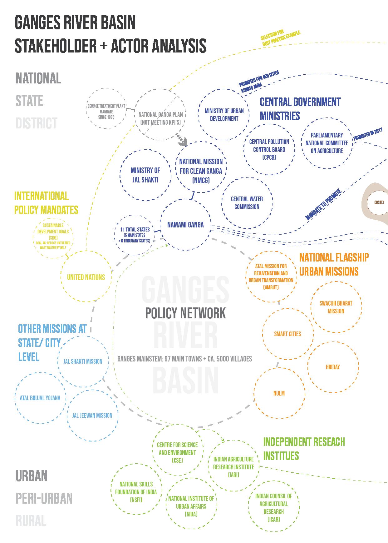
172 Ganges River in the Age of the Anthropocene
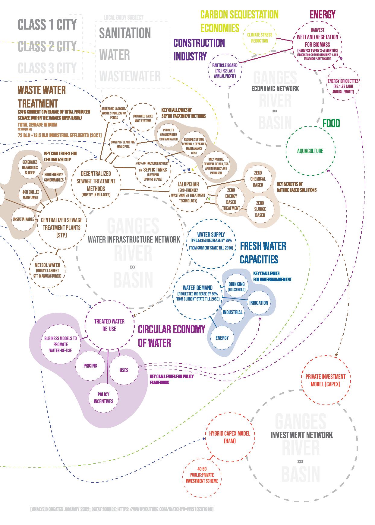
173 Appendix
Fig. 84: Stakeholder synergy diagram.
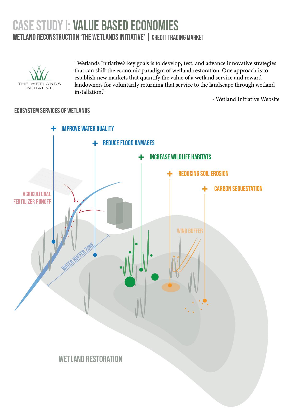
174 Ganges River in the Age of the Anthropocene
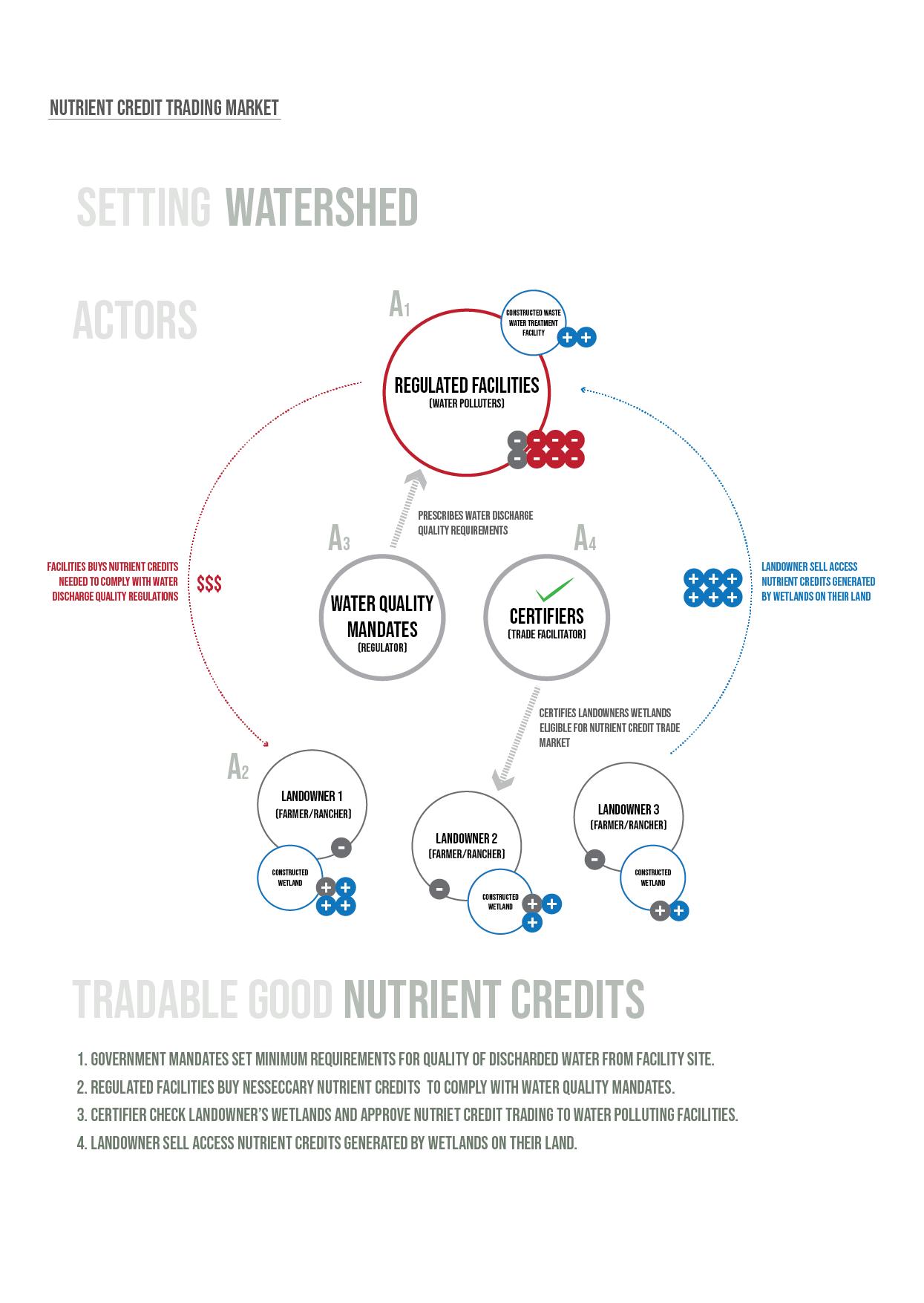
175 Appendix
Fig. 85: Case study of a value based economy.
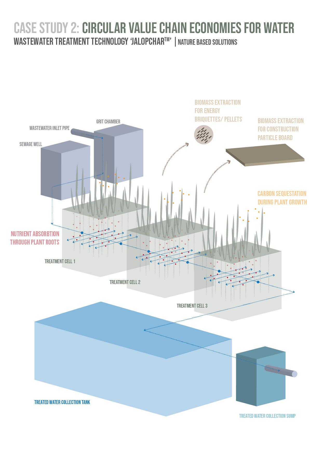
176 Ganges River in the Age of the Anthropocene
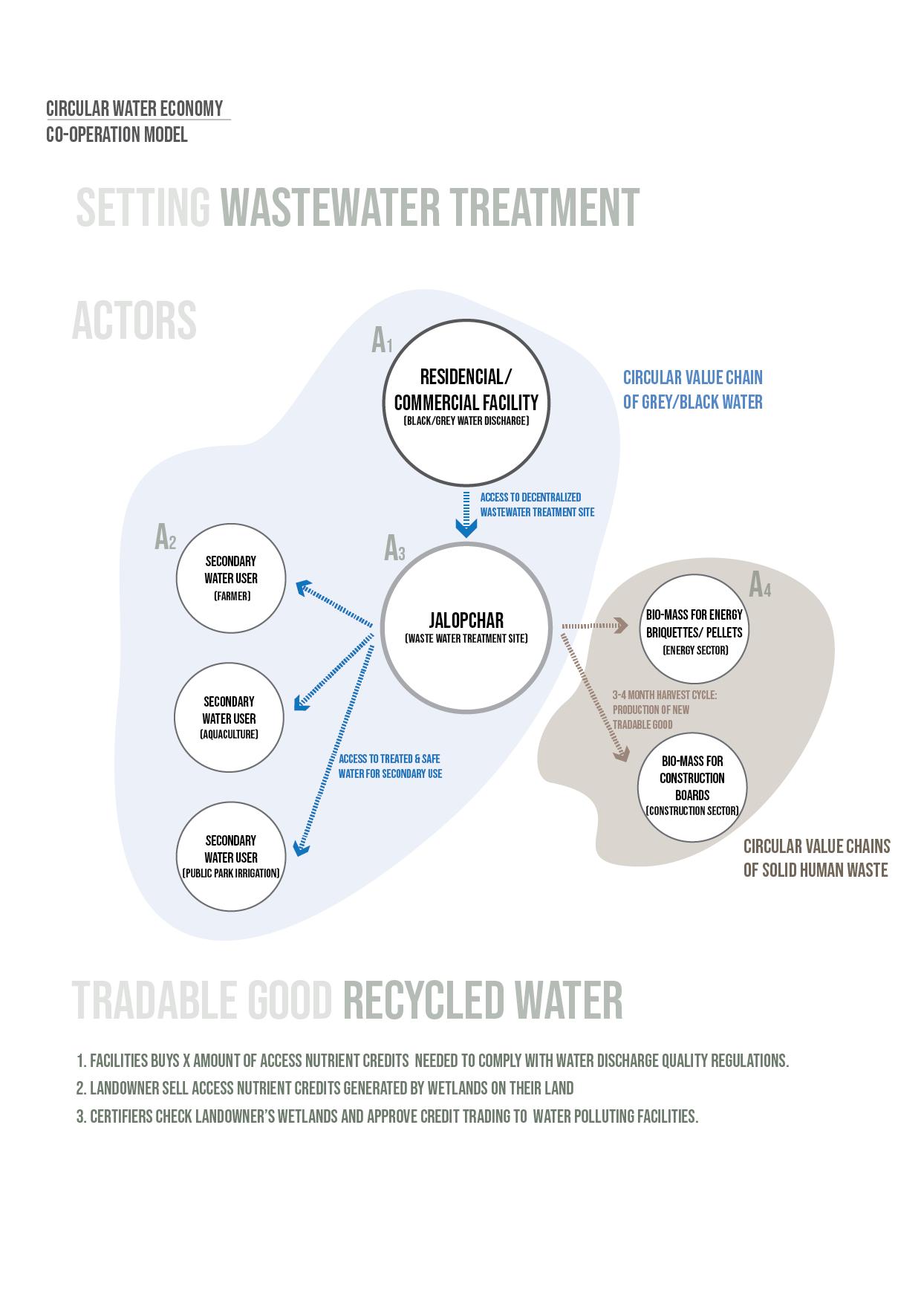
177 Appendix
Fig. 86: Case study of a nature based solution for wastewater treatment facility.
MASTER THESIS
Kriti Garg
Technische Universität Berlin
School VI Planning Building Environment
Department of Architecture
Habitat Unit (Chair of International Urbanism and Design)
Master Urban Design
Supervisors
Prof. Dipl.-Ing. Anke Hagemann
Anna Wilk-Pham
Berlin, September 2022

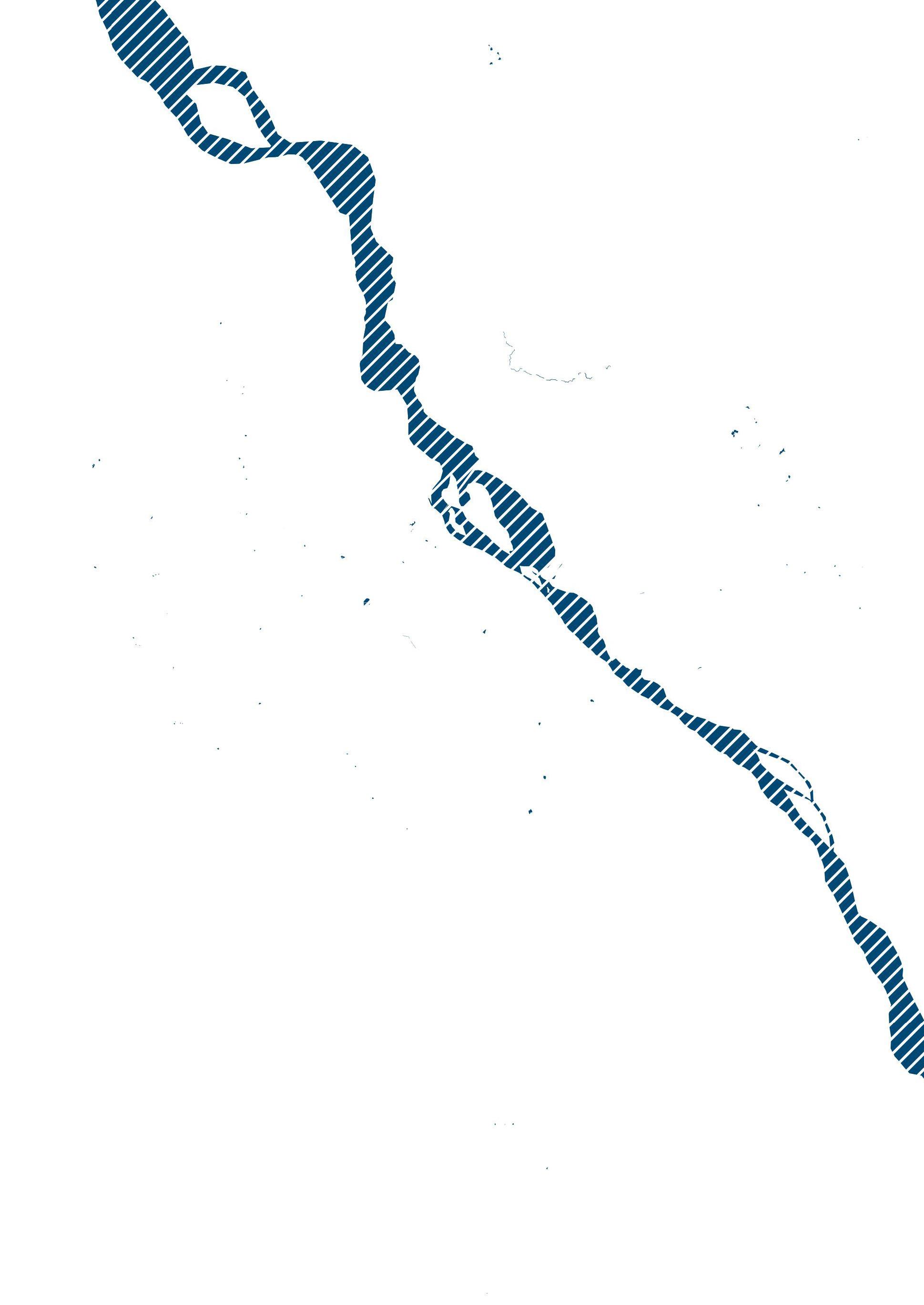
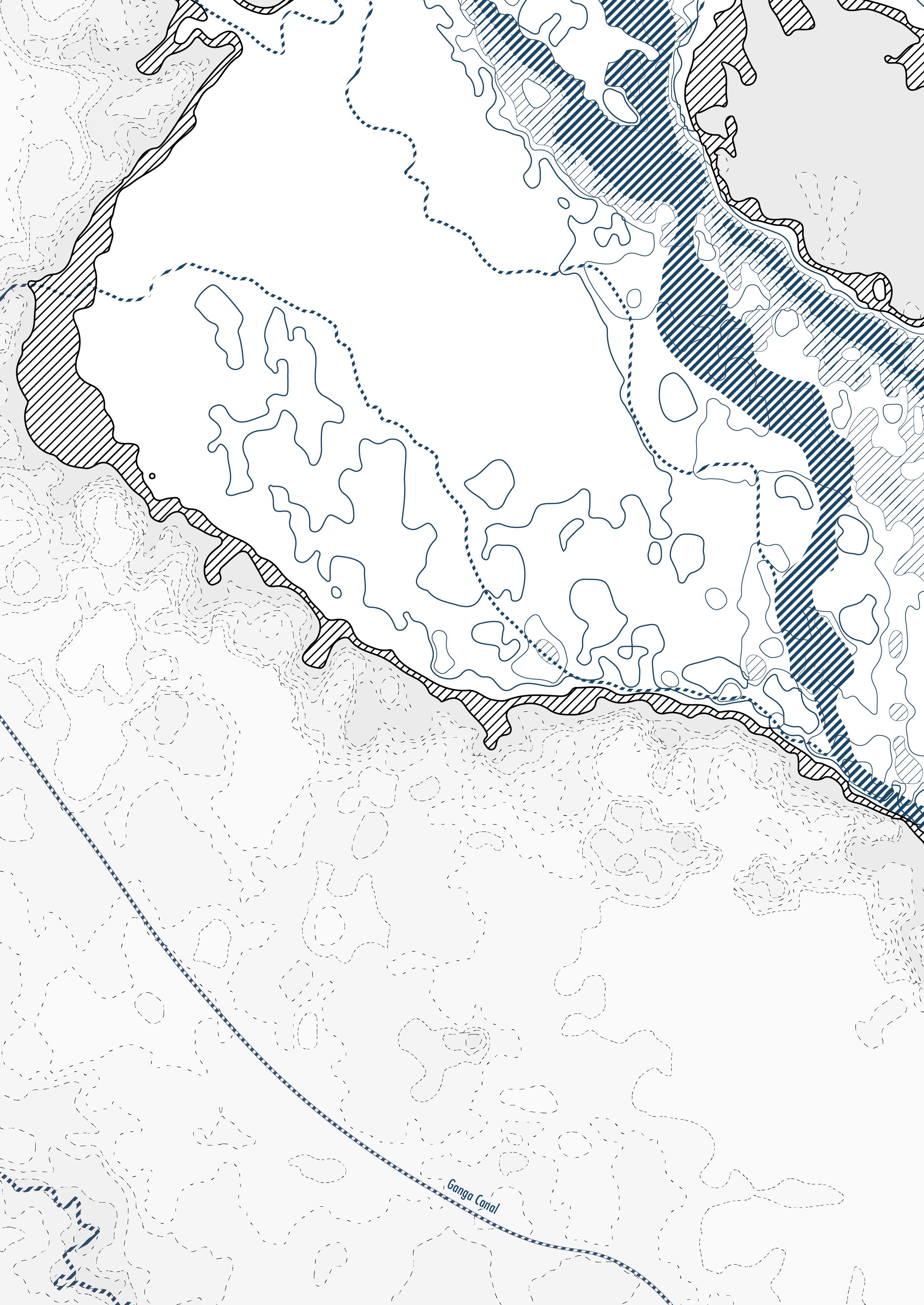
Ganges River in the Age of the Anthropocene
