2 minute read
International Showcase: USA
Landscape invited readers to submit their most inspiring ideas for addressing climate emergency. To start this new series, we present:
USA: Resilient Bridgeport: a prototype for vulnerable coastal cities

USA Resilient Bridgeport: a prototype for vulnerable coastal cities WSP
Bridgeport is an historic seaport city sitting at the junction of the Pequonnock River and Long Island Sound in the northeastern United States. The city is facing significant environmental challenges that require it to redefine the relationship between the city and the water for a stronger, responsive future. Resilient Bridgeport comprises a comprehensive resilience strategy and pilot projects focused on protecting homes, businesses and infrastructure from chronic and acute flooding, to foster long-term prosperity in the neighbourhood.
Situated between the Long Island Sound and downtown, the South End is Bridgeport’s most vulnerable coastal neighbourhood. Today, it is adversely affected by regular storm events and hurricanes and with ongoing climate change and sea level rise, impacts from these events will be amplified, causing ever-more damage. It is home to over 6,000 residents in historic houses, many of whom are lowincome, along with the University of Bridgeport’s campus, regional power generation & distribution facilities and the historic Frederick Law Olmsteddesigned Seaside Park, which provides sweeping views of the Long Island Sound.

University entrance
© WSP
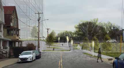
Building a seawall at the water’s edge in the South End to mitigate the risk of storm surge proved unfeasible for a variety of reasons. Instead, a structural flood protection barrier up to 4m tall threads through the middle of a mature urban neighbourhood. Rather than deploy standard engineering solutions, a multidisciplinary consulting team led by WSP USA is integrating the flood protection barrier and storm water management into a new public landscape network. It weaves together the heritage park, university campus and the historic neighbourhood, while setting a new elevated datum for future developments and providing dry egress during storm events.
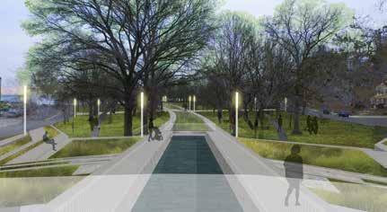
This landscape begins in the core of the University of Bridgeport with a dynamic, iconic, elevated, blue-green landscape introducing an organic, curvilinear design inspired by Olmsted’s language at Seaside Park. The new landscape will integrate existing buildings and paths into a visually cohesive system and, importantly, produce an exciting new identity for the campus between the park and the city.

Seaside Park
© WSP
At the east end of University Avenue, an elevated crescent plaza will literally and metaphorically connect the campus to the park head, forming a new gateway node where the park was historically connected to the city, as well as providing views into the park and of Long Island sound. Stormwater collected from inside the surge barrier will be pumped to this plaza, where it will dramatically spill into the park and through it, eventually flowing out to Long Island Sound. The fresh water introduced into the historic park through this system will help to alleviate some of the salinization of the soil occurring due to repeated storm surge events, while reconnecting visitors and residents to the hydrological cycle.
At the end of Main Street, a terraced pocket park will allow pedestrians and cyclists to connect to the elevated plaza, creating another attractive neighbourhood amenity. Through traffic will be directed up and over one of a number of new elevated streets, enabling new connections to formerly industrial waterfront sites which have stood empty for many years because they have no dry egress, opening their potential for new uses.
By Miranda Zhang Lead Planner, WSP


