
4 minute read
Walkable Cities


Walkable Cities By:Anna Klingmann
Turning Jeddah’s streets into walkable landscapes
Advertisement
Walking is the oldest and simplest form of human transportation. However, in Jeddah, walking a few blocks or crossing a street is not only an inconvenience but poses a danger to any pedestrian. With this project, our goal was to transform four car-oriented streets in Jeddah into integrated and pedestrianfriendly streets where people can effortlessly do their errands, shop, talk, sit and, most importantly enjoy themselves. Throughout the history of cities, streets provided people with vital public open spaces right outside their homes. Traditionally, streets represented not only circulation nodes but important places for people to linger, interact, and enjoy each other’s company. A turning point in the holistic perception of streetscapes as public mixed-use spaces happened during Modernist era with the widespread separation of car and pedestrian movement with priority given to vehicular motion. This affected the social, economic and environmental interaction of most communities in an adverse way, leading to suburbanized clusters with little vitality, a trend that is still prevalent in Jeddah today. Fact is that activated pedestrianoriented streets are essential ingredients of vibrant cities. As a part of Saudi Arabia’s efforts in the field of urban development and sustainability, this project was conducted with fifteen students at Effat University in Jeddah who worked in groups to redesign four major east-west roads in Jeddah from car-oriented unwalkable streets into vibrant pedestrian oriented streetscapes.
the case of Heraa street
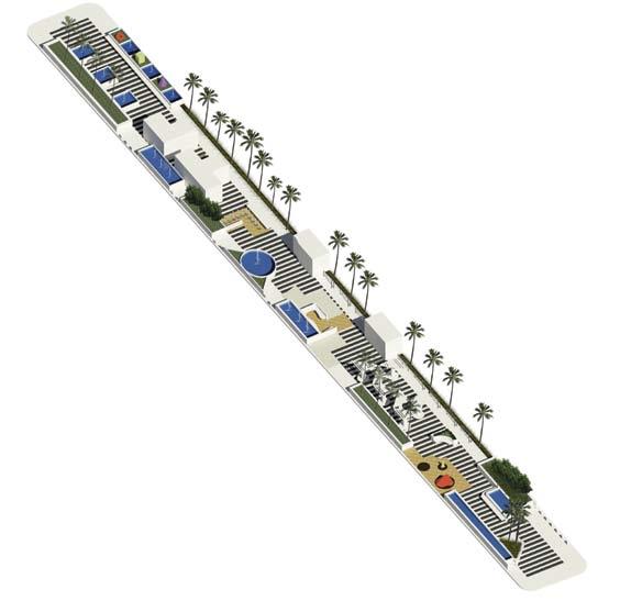
Student Team: Wed W. Al Yamani, Azzah A. Al Qarni, Atheer M. Al Mehmadi Heraa Street from the intersection with King Abdulaziz Street from the East to the intersection with Prince Faisal Bin Fahad Street from the West is a quiet residential street with few commercial projects and hotels. From an urban point of view, the street seems underutilized in many aspects, not only due to the number of brown fields that flank the street on both sides, but also due to the low level of social engagement and ineligible sidewalks. The location of the street, which is in close proximity to the city’s waterfront governs the high value of the surrounding properties, which in turn determines the affluent social class of the residents. However, the high economical level of the resident users is not reflected in the street’s negligent appearance and services. Accordingly, residents prefer to stay within their own properties particularly since the street does not serve them in on a social or commercial capacity. The students’ response to this dilemma was to create a vibrant outdoor/indoor district to activate the streets from both sides in order to better serve the residents and to promote the street as a cultural destination to visitors. Accordingly, the project focused on five objectives, which included the utilization of empty lots with commercial and cultural uses, urbanizing the street with activities, landscaping, and street furniture while also striving to maintain the privacy of the residents. Lastly, the intention was to identify the district with an iconic feature. To achieve these objectives, the students proposed an activated pedestrian strip, wrapped by a cycling loop in the center of Heraa street, which would, on the one hand, slow car traffic and, on the other, encourage pedestrian activity and easy access to adjacent commercial and cultural venues. In order to encourage social interaction, the mall provides a wealth of outdoor experiences, divided into four main zones. The first zone is a designated art zone where visitors can experience outdoor activities, artistic sculptures, impromptu galleries, and uniquely
designed seating areas. There are also designated zones for music and fashion, both of which allow for special performances and events. The last zone links Heraa Street with an open museum. Spaces here are shaded by mushroom-like canopies that provide shade for a variety of eateries connected to food trucks, as well as ground boards, art sculptures and exhibiting spaces. The urban spine passes through the entire district with the intent to activate adjacent street fronts and to create a source of connectivity between the recreational appeal of Jeddah’s waterfront and the western more commercial side of Heraa Street.
the case of Almaadi street
Student Team: Dania Sorour, Zahia Alraddadi, Weam Kufia Al-Maadi Street connects Al Ruwais to Al Hamraa, two districts, located in close proximity to the Corniche in the center of Jeddah. Tracing back the history of Al-Maadi Street, it appears that with expanding population growth, Al-Ruwais expanded towards the north, and a new parallel district was formed under the name of Al Hamraa towards the east. While Al-Ruwais used to be a fishing

village that dates back almost 300 years, and contains mostly single-family houses, Al-Hamraa is a much newer district that serves as a rental community, which is desirable to many foreigners.
In 2012, Al-Andalus highway was constructed and split the two districts apart, no longer allowing for any pedestrian movement between the districts. In addition, Al Ruwais was also now disconnected from the seashore. This isolation resulted in the emergence of two different social fabrics that could no longer connect with one another. The renovation project of Al-Maadi Street aims to reconnect both communities by transforming the barrier of AlAndalus street into a potential bond. Based on the users’ needs in both districts, a series of interventions were proposed that would encourage a crossover of residents from one district into another. These include a seaside destination with mixed-uses, a supermarket adjoining a plaza and a multifunctional sports field. The streetscape was improved by creating a continuous pedestrian linkage comprised of ample sidewalks, shading devices, and green buffers. Meanwhile, the highway was relocated into an underground tunnel, which permits for a more efficient traffic flow of vehicles and at the same time, ensures pedestrian safety.


