


Langan provides an integrated mix of engineering and environmental consulting services in support of land development projects, corporate real estate portfolios, and the oil and energy industry. Our clients include developers, property owners, public agencies, corporations, institutions, and energy companies around the world.
Founded in 1970, Langan employs over 1,750 professionals in its Parsippany, NJ headquarters and among regional offices in:
• New York City, NY
• White Plains, NY
• Melville, NY
• New Haven, CT
• Boston, MA
• Princeton, NJ
• Philadelphia, PA
• Bethlehem, PA
• Doylestown, PA
• Pittsburgh, PA
• Cleveland, OH
• Chicago, IL
• Arlington, VA
• Denver, CO
• Houston, TX
• Dallas, TX
• Austin, TX
• Tyler, TX
• Celina, TX
• San Antonio, TX
• Phoenix, AZ
• San Francisco, CA
• Oakland, CA
• Sacramento, CA
• San Diego, CA
• San Jose, CA
• Santa Barbara, CA
• Los Angeles, CA
• Riverside, CA
• Irvine, CA
• Bellevue, WA
• Seattle, WA
• Miami, FL
• Fort Lauderdale, FL
• Tampa, FL
• Jacksonville, FL
• Orlando, FL
• St. Petersburg, FL
• West Palm Beach, FL
• Charlotte, NC
• Nashville, TN
• Salt Lake City, UT
• Las Vegas, NV
• Portland, OR
• Milwaukee, WI
Langan International, the firm’s wholly owned subsidiary headquartered in New York City, provides all firm services for projects in the Middle East, Eastern Europe, Latin America, and the Caribbean. Langan International regional locations are in:
• Athens
• Calgary

• Dubai
• London

• Panama City

Langan’s survey group combines experience, technology, and responsiveness to meet our clients’ needs and maintain project schedules and budgets. The group is versed in traditional survey methods, as well as cuttingedge technologies including 3D Laser Scanning, UAV/Drones and BIM support. The group’s efforts are overseen by Professional Land Surveyors who bring experience and a solid knowledge of traditional methods to new innovative technologies. Seamlessly coupled with Langan’s integrated technical disciplines, the group is positioned to meet every survey challenge.
Langan approaches surveying problems with a combination of knowledge, experience and innovation that we believe renders the most efficient solutions while maintaining cost effectiveness. Our staff of professionals and specialists combines their knowledge and experience to provide comprehensive services to our clients. They are supported by field personnel who possess an understanding of both the technical aspects of survey and the practical potentials of design/construction. Either completing a standalone mapping task or when seamlessly coupled with Langan’s integrated technical disciplines, the group is positioned to meet every survey challenge. We apply the same degree of professionalism and interest to both large scale and small project assignments.
Langan Survey/Mapping Services:
• Boundary Surveys
• ALTA/NSPS Land Title Surveys
• Topographic Surveys
• GPS
• GIS/LIS Data Acquisition/ Systems
• Riparian Surveys
• 3D Laser Scanning
• Construction Stakeout
• Hydrographic/Bathymetric Surveys
• Environmental Surveys
• As-Built Surveys
• Photogrammetric Control

• Deformation/Monitoring Surveys
• Wetlands Location Surveys
• Utility Surveys
• Subdivisions
• Highway/Route Surveys
• UAV/Drones


Construction stakeout/layout is a crucial aspect of any construction project. It involves marking project limits, setting primary site control for other trades, indicating elevations, laying out building control, or providing offsets for structures. Reliable accuracy is critical to ensure the success of the project.
Langan offers construction stakeout services that utilize a combination of cutting-edge surveying equipment and traditional techniques to accurately mark the location and elevation of structures, utilities, and other site features. Our team of experienced professionals works closely with the construction team under the oversight of Professional Land Surveyors to ensure that the project moves forward smoothly.
But we know that throughout the life of a project, goals, conditions, and designs are bound to change. Therefore, quickly adapting to those changes is essential to maintaining project schedules. Langan’s ability to combine construction stakeout and other survey services with our integrated technical disciplines allows for increased responsiveness and rapid mobilization to address project changes and provide efficient and cost-effective solutions. At Langan we take pride in providing responsive, accurate, and reliable construction stakeout services.


3D Laser Scanning is changing the surveying/mapping industry and Langan is leading the revolution. Since the addition of High Definition Laser Scanning services in 2003, Langan has offered the most accurate and highly detailed existing conditions surveys possible. This advanced technology allows for the collection of millions of data points in less time and with lower overall cost than traditional techniques. 3D Laser Scanning equipment allows end users to accomplish project objectives more efficiently and accurately at all stages, in turn minimizing overall project costs and reducing turn around time, while achieving a higher level of detail.
Our ability to offer a combination of High Definition Laser Scanning and conventional surveying methods allow Langan to deliver a complete product. As with all of our surveying services, the scanning effort is overseen by Professional Land Surveyors who bring experience and knowledge of traditional methods to this cutting-edge technology.
In scanning, the data collected is known as a “point cloud” which contains a 3D database of the entire project area and allows the measurement of any surface information that is visible in the cloud to be used during the entire project lifecycle. After processing, the data from the “point cloud” can be utilized to produce dimensionally correct 3D models and/or 2D dimensional plans, with outputs to Microstation, AutoCAD or a host of other platforms. The registered data can also be used as a base to create highly detailed site visualizations or mass models. The end data can be used for the generation of existing condition BIM models, forensics studies, to determine possible construction conflicts, to validate construction/fabrication dimensions, or even to model major motion picture sets.
With prior technologies the end user had to work on the data. High Definition Laser Scanning allows the end user the ability to work in the data and be “on site virtually” with the push of a button.


Construction depends on sharing accurate data. The use of a Digital Twin, or Existing Conditions Building Information Modeling, as it is known to the AEC industry, is changing the way we use data. As in many other design industries such as automotive, aerospace, aviation and others where computer modeling is the norm, the construction industry now recognizes the benefits of this modeling revolution. Modeling allows the entire design team to use data in a new fashion, pre-assembly of the project in a virtual 3D world, not on flat 2D paper. By assigning attribute data to each component of a building, structure or site, the design team can assemble, analyze, coordinate, review, prepare cost estimates, and make informed decisions early in the design process. This new way of using data bridges a wide gap in the design process, greatly reducing cost and schedules while allowing the final product to be consistent with the original design intent. For the first time in our industry, IM allows a team member to truly visualize the data, and Langan is leading this 3D revolution.
Langan saw the benefits of utilizing a Digital Twin early on as our Survey Group was spearheading their way through the Nationwide 3D Laser Scanning Market. As with many design challenges, the need for accurate and precise existing conditions data is critical to the outcome of a project’s design. This need is greatly magnified with building reuse and interior construction projects. The solution was obvious, offer our 3D Laser Scanning services and provide the same level of “survey grade data” to the IM world (construction industry). Who better than licensed surveyors could understand the accuracy requirements and adjustments in scanning control needed to produce accurate existing conditions base mapping?
To date, Langan has successfully provided existing conditions data for a wide range of IM projects. From standard 2D CADD elevation and floor plans to fully intelligent 3D, 4D, and 5D models, Langan continues to lead the industry with unmatched solutions to complex challenges.


Langan has been actively positioned to provide Unmanned Aerial System (UAS) acquisition and data processing services to support and supplement our clients needs. Utilizing Unmanned Aerial Systems, Langan can provide aerial imagery products and services that are in compliance with Federal Aviation Administration (FAA) rules and regulation governing the commercial operation of unmanned aerial systems.
Langan’s UAS Data Collection and Mapping program has been designed to provide aerial video and imagery, orthophotography, digital point clouds, planimetric and topographic mapping products in various levels of accuracy on projects where the geographic size, location, budget or schedule of the project limits the effectiveness of a manned aircraft acquisition. Our UAS acquisition and processing team has the ability to mobilize quickly and efficiently, taking advantage of the nimbleness of the collection platforms. Processing of project deliverables as well as any required field control surveys are performed in-house, while being controlled, registered and projected to the level that satisfies most project requirements and specifications.
• Construction Monitoring
• Site Reconnaissance
• Site Design
• Aerial LiDAR
• Aerial Photography/Videography
• Orthophotography
• Colorized Point Clouds
• GIS/LIS Data Supplementation
• Wetlands Surveys
• Subdivision Surveys
• Campus Mapping
• Environmental Surveys

• Planimetric/Topographic Surveys
• As-Built Surveys
• BIM Modeling


As one of the emerging technologies in the Surveying/Scanning/Mapping/GIS profession, Mobile Mapping has been added to Langan’s capabilities. Langan has acquired a Leica TRK mobile mapping system and has built a team of professionals to provide our clients with these new services. Langan’s mobile mapping combines the usability and familiarity of videos and photographic images with the accuracy and precision of LiDAR point clouds to deliver a total asset management solution.
The TRK is fully transportable and can be shipped anywhere in the world to provide cost effective mobility while maintaining the accuracy and precision required by our clients. The TRK can be placed on a vehicle for roadway based collection, on a boat for shoreline or bridge projects, on a rail car for railway and transit applications, or even on an ATV/UTV for off road uses in the Utility, Oil and Gas, and Electrical energy industries. Langan’s survey and mapping group has been a leader in the 3D scanning and BIM markets for years by providing survey grade existing information in innovative formats. The new mobile mapping department is the next part of that innovation.
Langan Survey/Mapping Services:
• Boundary Surveys
• ALTA/NSPS Land Title Surveys
• Topographic Surveys
• GPS
• GIS/LIS Data Acquisition
• Deformation/Monitoring Surveys
• Wetlands Location Surveys
• Utility Surveys
• Subdivisions
• 3D Laser Scanning
• Campus Mapping
• Mobile Scanning/Mapping
• Construction Stakeout
• Hydrographic/Bathymetric Surveys

• Environmental Surveys
• As-Built Surveys
• Photogrammetric Control
• Riparian Surveys
• Highway/Route Surveys
• BIM Modeling
• Geographical Information Systems


Langan utilizes the latest software solutions designed to collect, manage, analyze, and visualize mass quantities of both spatial and non-spatial data to assist our clients in unlocking the full potential of their business data. We transform raw data into intelligent action, enabling the ability to make data-driven decisions confidently and efficiently.
Langan’s technology solutions bring data to life, making it more accessible and actionable for users at all levels of an organization, translating to improved business outcomes, optimized operations, and increased competitive advantage. This enables our clients to harness the power of their data and turn it into a strategic asset that drives meaningful and transformative change in their business.
Langan Digital Solutions Services:
• GIS Mapping and Analysis
• Field Data Collection / RealTime Mapping
• Data Dashboards and Web Viewers
• Map-Based Document Management
• Data Interpretation, Management and Analysis
• Process/Workflow Development
• Spatial and Non-Spatial Data Integration
• Data Visualization
• Historical Data Acquisition
• Enterprise Software Integration
• Custom Solutions
• Site Analysis
• Litigation Support
• Asset Management
• Indoor Mapping Systems
• Web and Mobile Application Development
• Process Automation
• Automated Figure and Report Generation
• IoT / Real-Time Data Capture and Reporting
• AI / Machine Learning
• System Architecture Design and Implementation
• Enterprise Systems Integration
• Custom Tools
• Data Extract, Transform, and Load (ETL) Services
• Interactive Data Exploration
• Custom Viewers and Websites


Education
• A.S. Construction Technology, New Jersey Institute of Technology
Professional Registration
• Professional Land Surveyor (PLS) in CT, DC, FL, NJ, NY
Mr. Romano has a broad range of experience in surveying, construction and design-related fields for over 43 years. Starting his career as a title searcher, he developed his expertise while working as a draftsmen, construction inspector, rodman and survey party chief, and department lead. His experience in land surveying ranges from traditional survey tasks, including highly detailed geodetic networks, to advanced mapping technologies and expert witness services.
As Director of Surveying and Manager of the Langan Survey Department, Mr. Romano is very active in promoting land surveying and has been a guest speaker at numerous national and international conferences. In addition to his areas of special interest, which include boundary law and GPS/GIS/Laser Scanning technologies, his passion to give back to the surveying profession, as well as other aligned professions, has inspired him to be active at the Board level of numerous educational institutions and professional organizations. Of special note is his cofounding of the USIBD (United States Institute of Building Documentation), the only nonprofit organization dedicated to the profession of building documentation.

Education
• A.S. Engineering Naugatuck Valley Community College
Professional Registration
• Registered Professional Land Surveyor (PLS) in MA, CT, NY
Mr. Ives has over 22 years of experience on projects throughout the northeast including Massachusetts, Connecticut, and New York. He provides land surveying and mapping services in both the public and private sectors, and is responsible for project coordination, research, field location, mapping, boundary determination, and construction stake out services. He currently oversees surveying services for the Northeast with staff in White Plains, NY, New Haven, CT, and Boston, MA and holds licenses in New York, Connecticut, and Massachusetts.

Mr. Higgins has over 30 years of experience in all aspects of land surveying. He is wellversed with all types of modern surveying field equipment and various software systems for computer aided drafting. The majority of Shaun’s experience has come as a survey project manager, in charge of field and office personnel involved with gathering and manipulating existing conditions information for residential, retail, institutional and commercial properties and preparing and managing construction layout projects for various types of development. Shaun also has extensive experience with 3D laser scanning and modeling services.
Education
• B.S. Surveying, Survey Law/ Survey Math
Dublin Institute of Technology
• A.S. Construction Engineering, Civil Engineering Galway/Mayo Institute of Technology
Professional Registration
• Professional Land Surveyor (PLS) in PA, NC, VA, WV

Education
• B.A., Criminal Justice Rowan University
Professional Registration
• Professional Land Surveyor (PLS) in NY
Mr. O’Connor an experienced surveyor in all phases of boundary, topographic, and utility surveys. He also has extensive experience in performing various surveys for the oil and gas industry, conducting hydrographic studies, 3D laser scanning, and 3D modeling. Mr. O’Connor experience has allowed him to be responsible for large scale infrastructure projects requiring multiple aspects of survey services and technology primarily in the New York City area. Mr. O’Connor has worked on numerous projects throughout the United States and internationally. He is responsible for the management of Langan’s 3D laser scanning and modeling group.

Education
• Civil Engineering Coursework University of Texas at Austin
Professional Registration
• Professional Surveyor in TX, MS, AR, OK, CO, KY
Mr. Hoebelheinrich leads a team of 25 survey professionals across Texas and is responsible for overseeing daily operations, providing guidance on complex survey tasks, reviewing contracts, and preparing scopes of work for proposed projects. With extensive experience in commercial development, ALTA/NSPS Land Title Surveys, and providing expert witness testimony, Mr. Hoebelheinrich ensures that his team delivers high-quality work to Langan’s clients. His licensure across multiple states, including CO, OK, AR, MS, TX, and KY, provides a unique perspective to solving issues as they arise. Mr. Hoebelheinrich’s commitment to excellence and his ability to provide his team with the necessary personnel and equipment to complete their daily tasks make him an invaluable asset to the firm.

Education
• A.A.S., Civil Engineering Technology, Monroe Community College
Professional Registration
• Professional Surveyor and Mapper (PSM) in FL, NY
Mr. Merritt is a licensed land surveyor with an extensive background that includes terrestrial and mobile LiDAR (laser scanning), GPS surveys, GIS Development, horizontal/ vertical control, right-of-way survey and mapping projects, preliminary design surveys for engineering projects, and ALTA boundary surveys. His experience in land surveying ranges from traditional survey tasks to advanced mapping technologies. He has over 37 years of professional surveying experience and has been managing projects for local governmental agencies such as Palm Beach Gardens; Palm Beach County; Miami-Dade County; St. Lucie County; SFWMD; Florida DOT Districts 4 and 6 as well as multiple towns and villages throughout South Florida since 2005. As Manager of Surveying for the State of Florida, Mr. Merritt is very active in promoting land surveying and has been a guest speaker at numerous conferences. He is part of curriculum advisory board at Florida Atlantic University Geomatics Engineering program.

Education
• B.A., Advertising Texas Tech University
Professional Registration
• Professional Surveyor in TX
Mr. Chadd oversees the day-to-day operations of the Dallas and Tyler surveying departments. Jewel leads by example and is responsible for the development and the growth of the departments and its staff. His demand for a high level of professionalism together with his commitment to efficiency allow for the timely completion of high- quality projects.
Jewel has over 20 years of experience as a Texas licensed surveyor (more than 30 years of in surveying) and 15 years of management experience. He has overseen and managed countless surveying projects for private and public entities, including K-12, airports, radio towers, utility routes, commercial warehouses, QSR, and retail developments. The types of surveys includes more than 20 years of platting, zoning descriptions, ALTA/NSPS Land Title Surveys, topographic surveys, route surveys, municipal boundaries, horizontal & vertical control monuments, monumenting floodways, FEMA (flood study), and exhibits for easements, easement abandonments, right-of-way dedications, encroachment agreements, boundary-line agreements.
Jewel is a US Army veteran and a member of the Texas Board of Professional Engineers and Land Surveyors’ Exam Licensure Group.

Education
• B.S. Survey Engineering Technology, New Jersey Institute of Technology
Professional Registration
• Professional Land Surveyor (PLS) in NJ
Mr. Sipple has over 23 years of experience and specializes in field data reduction and preparation of detailed drawings based upon 3D point clouds and conventional ground based survey information. Over the years he has worked on projects ranging from large scale public/private redevelopments to highly detailed models for part replications. Mr. Sipple has also been developing solutions to incorporate highly accurate existing condition models into Information Models and Facility Management systems for long term asset and facility operations. His expertise helps the Langan team remain on the cutting edge of technology.

• B.S., Surveying and Mapping Technology
University of Akron
Professional Registration
• Professional Land Surveyor (PLS) in OH, IL, KY, WV
Mr. Maione is a professional surveyor with extensive leadership experience and knowledge of the principles, practices and procedures of ALTA, topographic, boundary, utility and construction layout surveys. He has delivered successful results in the land development and oil and gas industry and efficiently managed numerous projects and many field and office personnel. Mr. Maione has created strategies under changing conditions and has demonstrated excellent communication skills with other disciplines, outside agencies, and clients.


• Professional Pay: Highlights From POB's 2013 Salary & Benefits Study, P. 10 • Improving International Data Management Through GIS, P. 18 • The Benefits of Real-Time Office-to-Field Collaboration, P. 26


By Christine L. Grahl
Technology advances are making it faster and easier for surveying and mapping professionals to collect data and provide increasingly sophisticated deliverables that solve complex problems for clients. But the situation also presents a challenge. With technology changing so rapidly, any new investment typically must pay for itself within five years, if not less. How can a firm make a solid business case to invest in the latest state-of-the-art system?
At Langan, an international engineering and environmental consulting firm headquartered in Elmwood Park, N.J., staying on the leading edge of 3D laser scanning technology is a chief objective for the firm’s surveying and mapping group. An early adopter of scanning technology, the company has rapidly expanded its arsenal of laser scanning equipment and expertise within the last several years. In 2006, the firm purchased one of the early Leica Geosystems ScanStation units. Since then,
the firm has added a Leica ScanStation 2, a Leica HDS6000 and a Leica ScanStation C10. Recently Langan became the first to purchase the new Leica ScanStation P20, an ultra high-speed laser scanner that provides high scan density and high accuracy.
At any given time, all five of the scanners are in operation on various projects, from large infrastructure surveys to building information modeling (BIM) for a wide range of facilities and clients, and Langan sometimes needs to rent additional scan-
With technology changing rapidly, making the business case to invest in new equipment can be a challenge. How do you know the investment will provide a return? Here are six strategies from a surveying and mapping group on the leading edge.
ners to meet demanding project deadlines. How has the firm made laser scanning such a successful part of its business? According to Joseph Romano, PLS, vice president of the firm’s surveying and mapping group, there are no shortcuts. “With technology, everything is very dynamic; it’s always changing,” he says. “You have to keep track of the latest advances and make smart decisions to stay on the leading edge.”
Following are six strategies that can be implemented by any firm seeking to get the best return on their technology investment.
The rapid pace of technology innovation presents exciting new opportunities, but trying to keep up with all the latest advances can be both frustrating and futile. Instead, investments should be made strategically and aligned with the company’s primary areas of expertise. “We can’t jump on every new technology as it comes out just because it’s new,” Romano says. “We have to make sure we’re making the right decision. Each piece of equipment has a specific role and fits a niche for us. We have to stay within our core strengths.”
Investing in new technology is just one part of the equation. Although some clients might actively seek service providers who use the latest piece of equipment or software, most are more interested in how a firm’s capabilities fit a specific need. “As clients become more knowledgeable about the equipment and options available, having current technology is important,” says Matt Sipple, PLS, project surveyor for Langan, “but being able to explain why we use that equipment is just as critical.”
For example, being able to share how the density of data captured by the latest laser scanner can save time and money downstream compared to an older technology can be big selling point. “On some of the long term projects we’re involved with, we have been asked to rescan for details that previously we were unable to obtain,” says Sipple. Equally important is the ability to convey the benefits that experience and skill bring to a project. An important step in any new project or client relationship is to understand the expectations of everyone involved and avoid the temptation to oversell capabili-


ties. The technology alone is not enough to guarantee success; having adequate training and knowing when and where to apply the technology are vital.
With the trend toward building information modeling (BIM) and integrated project delivery (IPD), clients are looking for ways to add intelligence to their datasets. Often software can be a differentiating factor in choosing a service provider. “BIM and IPD are becoming more common as a final deliverable, and there’s a lot more demand for 3D design,” Sipple says. “Clients want more working models and datasets they can integrate into their own workflows. Staying on top of software development is critical to meeting these needs.”
Technology manufacturers and independent software developers have introduced new software solutions in the last few years that automate and streamline data processing and management. One example is Leica CloudWorx for Revit, a plugin that allows as-built point cloud data captured by laser
scanners to be manipulated directly within Autodesk Revit software for an improved BIM workflow. “Previously we’d have to export the point cloud out of Cyclone and import it into Revit, and we’d lose our coordinate system and orientation because the software wasn’t compatible,” Sipple explains. “As surveyors, we have to ensure that everything is survey-accurate, so that meant a lot of time on our end correcting the model. CloudWorx for Revit has allowed us to bring in point clouds accurately, which saves us a lot of time in transferring files and checking for discrepancies.”
The streamlined workflow has allowed the firm to provide accurate deliverables much faster, which is a benefit to clients on a tight timeline. It also allows Langan to make better use of its internal resources. “Now we can have one person working on one side of the building and another person on another side of the building, each on a different part of the point cloud, and they’re all tied together because they all go back to Cyclone,” Sipple says. “It reduces the chance of error because we don’t have


to split the data up and transfer to it other software packages. If additional data is brought in, everyone has access to it. And we don’t have to worry about the loss of data due to software incompatibility.”
A benefit of modern technology is that it can expand a surveyor’s capabilities far beyond what was traditionally possible. Although there is such a thing as providing too much data all at once (does the client really need billions of points in that model?), it can be difficult to predict the downstream requirements of a project.
“Once we’ve collected the data, we can't increase its accuracy, so it needs to be collected correctly and for more than its intended purpose,” Romano says. “We try to anticipate our client’s needs and structure our data collection efforts accordingly.”
For example, the group frequently uses its ScanStation C10 when working on building exteriors due to the instrument’s speed, range and color capabilities, as well as its abil-
Left: Langan's 3D laser scanning projects have included St. Patrick's Cathedral in New York (top) and the U.S. Court of Appeals of the Armed Forces in Washington, D.C. (middle). A benefit of laser scanning is the ability to provide MEP models (bottom) without having to return to the site. Right: Langan's survey technicians used a combination of 3D laser scanning technology and traditional surveying methods in support of renovations at the 21,000-square-foot Madison Square Garden arena.
ity to capture a full 360-degree dome scan. Although the dome scan requires a few extra minutes of scan time, the additional data is invaluable. “It allows us to capture the scene— to get data everywhere surrounding the project site in case any other needs arise,” Sipple says. “We’ve had projects where the client has contacted us several weeks later wanting to know the elevation of the building next door, or an MEP designer needs models of the building’s existing mechanical, electrical and plumbing, and we were able to provide that data without having to go back onsite.
“Making additional data available as needed keeps the costs manageable for the client while streamlining the process. It also allows us to continue to add value as a project progresses.”
Achieving success with a new technology requires identifying the potential barriers as well as knowing how to skillfully remove them. For example, individuals within a firm might be resistant to change or may lack the understanding needed to fully embrace a new technology. Creating a seamless flow of information often requires adapting to new processes and breaking down silos between roles or departments.
Barriers can also exist in a client’s understanding of a technology or process. “Everyone is at a different stage in technology adoption,” Romano says. “Some clients want everything in BIM, and others just want 2D drawings. Whenever we meet with a new client, we try to assess their level of technology awareness and identify any preconceptions they might have about the process. Then we either have to adapt to what they want or guide them to alternative solutions based on our knowledge and expertise. We have to spend a lot more time in planning to ensure a successful outcome.”

Relationships are crucial in business, and this is especially true when investing in new technology. Having a strong network of partners and clients can make all the difference in how quickly a new technology investment provides a return. “We value the relationships we have with our hardware and software providers,” Romano says. “The feedback we give to them is critical, and they’ve never let us down.”
Langan also maintains relationships with past clients and participates in professional and community events to make sure the firm understands where the needs are in the market. “Some of our past clients that didn’t have an interest in 3D previously now have a client that wants something in 3D or BIM. They’re calling us up saying, ‘Hey, I remember you guys had that 3D laser scanning technology,’” Romano says. “In other cases, we’ve made connections at a trade show or professional event that took time to come to fruition but led to new projects eight to 12 months later. It’s all about relationships, and you have to nurture those wherever you are in the process.”
As clients seek increasingly complex deliverables, technology advances will continue to play a key role in enabling surveying and mapping professionals to add value. With the right strategy—and perhaps a little patience—firms can reap the benefits of a good technology investment.
“This has been a long road for us in scanning,” Romano says. “It’s rewarding to see our efforts paying off.”
Christine Grahl is the editor of POB. She can be reached at pobeditor@bnpmedia.com. For more information about Langan, visit www. langan.com. Additional details about Leica Geosystems laser scanners and software can be found at www.leica-geosystems.us.


Credit: Jonathan Hillyer

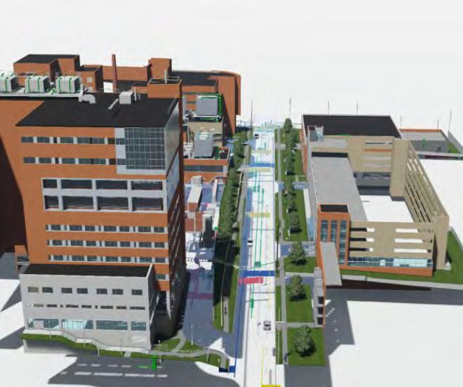
This 530,000 SF surgical and intensive care “smart hospital” added 250 private patient rooms, 24 operating suites, and incorporated innovative technology into a thoughtfully designed space to provide a collaborative atmosphere for patients, physicians, and medical staff. The project also includes the construction of a new Central Utility Plant (CUP) near the facility. The 43,000 SF building centralized campus heating, cooling, and electrical supply systems.
Langan’s survey team completed a full site survey of the project area to support the site design. This site survey included full boundary, topography and details for the complex utility and communications systems. This survey information was then modeled with BIM tools to create an existing condition BIM of the sites surface and subsurface features.
As part of the survey task the group also completed a full 3D scan for the existing buildings within the project limits. This included exterior, interior and roofs of each building. A survey grade existing conditions BIM model of the buildings was completed and incorporated into the site BIM to complete one seamless existing condition BIM of the project area.
The ability to provide the design team with an accurate BIM of the site was vital to the team as the design team is designing in BIM. The model used the BIM for building placement, site and utility connections, and design.


New York, New York
Moynihan Train Hall is a $1.6 billion world-class transit hub located within the James A. Farley Building and across from New York Penn Station. At 255,000 SF, the development nearly doubled the available concourse space and provides access to Amtrak, NJ Transit, New York City Transit subway, and Long Island Rail Road. Prior to completion of the train hall, an average of 650,000 people traveled through Penn Station daily, triple the number it was built to handle. With the expansion, the hub can now accommodate one million commuters daily.
Langan has worked on the redevelopment project since 2000, first providing a design-level site survey of the building to inform concepts for its exterior, as well as boundary, topographic, and subsurface utility surveys. We later returned to the site to perform high-definition 3D laser scanning of the structure (including the tracks below the Farley Building), building interior, and rooftop.
Jamaica, New York
The Trans World Airlines (TWA) Flight Center at JFK International Airport underwent a complete renovation. Originally opened in 1962 and shut down in 2001, the Eero Saarinen-designed New York City landmark was transformed into a 512-room hotel with two six-story buildings and 50,000 SF of meeting and event space.
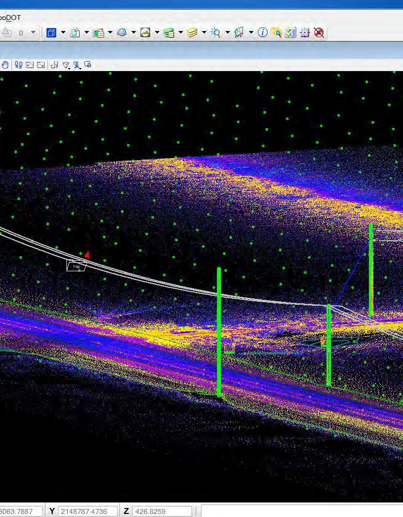
Langan provided mobile LiDAR data collection, feature extraction, and mapping services for the TWA Historic Flight Center at JFK Airport, New York for MCR Development. Langan deployed its Pegasus Mobile Mapping System within JFK Airport and collected integrated video logging and LiDAR data for the project area. Langan brought the LiDAR point clouds into Leica’s Map Factory and Certainty 3D’s TopoDOT products to extract roadway and vertical features. The list of extracted features included signs, posts, signals, hydrants, valves, manholes, curb, sidewalk, pavement markings, centerlines, poles, overhead wires, building footprints, and storm grates.


This major New York City rezoning and redevelopment, under the joint guidance of The City of New York, the Metropolitan Transportation Authority (MTA), Hudson Yards Development Corporation (HYDC) and State of New York initiatives, is in the process of reinventing the Hudson Yards area in Midtown Manhattan. Once complete, the site will include more than 18,000,000 SF of commercial and residential developments and 14 acres of open park space, as well as a cultural venue, 750-person public school and 200-room luxury hotel.
Our survey team conducted 3D laser scanning services for the project. 3D Revit models were developed for the West Rail Yard, Highline, 7 Line, Amtrak tunnels, and Empire Line. Furthermore, our survey team completed Alta/NSPS surveys, easement preparation, written descriptions, and boundary, topographic, and utility surveys for the site.
Washington, DC
With over three million visitors annually, the John F. Kennedy Center for the Performing Arts serves as an icon of the District of Columbia and the Potomac River, presenting the greatest performances of music, dance, and theater. In need of additional space for its existing and growing programs, the Kennedy Center expanded its facilities by 78,000 SF including three pavilions and a pedestrian bridge as part of the REACH campaign.
The project presented numerous site design challenges to achieve the project’s architectural vision. Langan was retained to provide site/civil, environmental, and geotechnical engineering; natural resource permitting; survey (including 3D laser scanning); and hazardous materials consulting for the expansion. As part of its services, Langan performed a geotechnical and environmental subsurface investigation.


In late 2022, NASA launched the Orion spacecraft on a 26-day mission around the moon via the Space Launch System, its new heavy-lift rocket. The unmanned Artemis I launch is the first in a line of complex missions aimed at enabling exploration of the Moon and Mars. But before the Orion spacecraft was launched into space, it first had to be moved from the Vehicle Assembly Building to the Kennedy Space Center launchpad.
Enter the Crawler-Transporter (CT), four connected, building-sized vehicles on rolling tracks that, when loaded with the Orion and its mobile launcher, carried over 25 million pounds. That’s the equivalent of 1,020 school buses, the heaviest overland loads ever recorded. As the CT moved along the Crawlerway, it had the potential to sink into the ground, tipping and causing its payload to fall off. The resulting damage would have placed the entire mission in jeopardy, along with the $20+ billion invested in the Orion.
To address this risk, the agency partnered with engineering firms Langan and Jones Edmunds to monitor ground deformation under the CT in real-time. Langan developed a surveying process that took measurements on both sides of the CT simultaneously, collecting data every 10 feet along the 4.1-mile Crawlerway.
The biggest challenge: Langan needed to survey the CT in motion. This required establishing hundreds of control points for the baseline setup alone. Real-time surveying of the CT involved a team of 14 professionals working together, their movements carefully timed as the CT crept along at roughly 26 feet per minute. Designing the solution took a full two years—and had to account for many moving parts.
The first step of the project involved mounting surveying prisms on the CT without altering the CT itself, which the Langan team achieved using high-strength brackets. The second step included conducting trials to develop observation procedures and timing for surveying teams. Third, the team established the survey control networks, setting up control points every 600 feet to measure location and elevation to one one-hundredth of a foot. The last step put the team’s preparation to the test— observing the CT while in motion under varying weights, from 22.5 million pounds to 25.5 million pounds.


The Hard Rock Stadium grounds underwent a successful adaptation to host the Formula 1 Miami Grand Prix. The venue extends over three stadium parcels and portions of the Florida Turnpike right-of-way, and includes a 3.3mile racetrack with 19 turns and three straightaways where cars reach speeds of up to 210 MPH. It also provides a pit paddock building that can accommodate up to 93,000 spectators, with grandstands, fan amenities, and two levels of VIP suites.
Accuracy was imperative for the success of this project. Existing conditions for the 240-acre site required positional accuracy within one centimeter. We combined mobile mapping (LiDAR), terrestrial LiDAR, and traditional surveying methodologies to provide the most efficient survey for the racetrack. Approximately 350 survey controls were required, and we obtained information on over 1,000 utility structures. Our surveyors also worked closely with the site/civil team, conducting an initial topographic survey and DTM to support the site/civil design.
As part of the Terminal C project at Orlando International Airport, Langan provided as-built survey for various components of the air-side terminal steel erection. Langan verified the existing on-site control where over 2,600 anchor bolts were located and over 500 columns were observed for plumbness. Langan completed laser scans of four shear towers to verify the locations of various welding plats to hang steel girders.
The expansion includes the addition of 19 gates capable of accommodating at least 24 aircrafts. The three-floor facility is adjacent to the South Airport APM Complex and Intermodal Terminal Facility.
This complex project ranks as one of the largest airport expansions projects in the United States. Project challenges included working around a large workforce of about 1,800 workers at a 300-acre site. At peak work force there were up to 2,500 workers on the project site.


Colorado Springs, Colorado
Built in 1962, the U.S. Air Force Academy Cadet Chapel is a striking aluminum, glass, and steel building with 17 spires reaching heights of 150 feet and seating for nearly 2,000 people. It serves as an all-faith center of worship for cadets and includes Protestant, Catholic, Jewish and Buddhist chapels, an All-Faiths Room, and a Falcon Circle, each with its own entrance. The Chapel is capable of holding services in all rooms at one time. In 2004, the chapel was recognized as a U.S. National Historic Landmark. The building is currently closed as it undergoes a major renovation and restoration. Langan’s survey team is laser scanning the structure and delivering the information needed to finalize the design of the new “skin” that will cover the chapel. We are also precisely locating and documenting the various structural elements that make up the 75-foot-long, fiveton spires, and designing moveable platforms that can bear the weight of the equipment used to laser scan those spires.
Houston, Texas
Langan worked on a project in the interstitial space between the basement and 1st floors of the Clinical Research Building at The University of Texas MD Anderson Cancer Center. The project entailed raising the ceiling level of the basement research areas by 1 to 2 feet and shrinking the area of the existing interstitial space, which was initially very dense with MEP equipment.
Langan was responsible for performing a 3D Laser Scan and 3D Revit Model for the almost 15,000 square foot interstitial space. This model is used by the design team to produce accurate design drawings which will allow for the prefabrication of many of the new utility runs that will need to be made for this renovation, thus cutting down on overall construction time.
Langan was chosen for this project due to our experience in scanning dense and difficult MEP areas as well as our ability to produce an accurate 3D model with our inhouse modelers.


This 350,000 SF project included the development of a football stadium and field house. The project was completed by repurposing unimproved campus land together with adjacent improved tracts and rights of way.
Professional Land Surveying & Engineering Support Surveying services included:
• Real property boundary determinations across several city blocks
• Topographic surveys
• Utility locations
• Horizontal control
• Vertical control
• Benchmark descriptions
• Exhibit sets for easements
• Exhibit sets for easement abandonments pre city standards
Godley, Texas
• Exhibit sets for encroachment agreements
• Historical land and street research
• Metes & bounds land descriptions
• Closure reports
• Final Plat recorded under Instrument No. D223096823, Tarrant Co.
• Stormwater Facility Maintenance Agreement
Survey services are being provided in support of the new Godley High School, AG facility, existing campus renovations, and technology updates. Survey services include bounday and topographic surveys of 140-acres, a utility survey that included topography of 3,200 LF of waterline, established control network with 20 monuments, and a 69-acre as-built survey between the HS and AG land. Additional services, including topographic surveys for flood zone determination, are anticipated for this project.

Alcatraz Island, San Francisco Bay, California
The National Park Service is evaluating options for protection and preservation of cultural and natural resources at one of its most popular parks. Natural erosion of the cliff face over time is encroaching on the historically significant features of the former prison site. The Langan team performed a 3D laser scan of the cliff face at the island’s southern end. The scan provides a baseline of the existing condition as well as detailed imaging and linear information used to evaluate the structure of exposed rock. Our recommendations included combinations of steel rock bolting and face treatment via high-strength steel mesh netting and shotcrete. The cliff stabilization was carried out in two phases during which we provided construction administration and quality control services.
Fresno, California
Langan provided mobile LiDAR data collection, feature extraction, and mapping services for Little Bear Solar. We deployed our Pegasus Mobile Mapping System within the Little Bear Solar Farm and collected integrated video logging and LiDAR data for the project area. Survey control points were placed within the project limits to register the LiDAR and imagery data with. Langan’s LiDAR and imagery data was survey grade accurate (+/.02’).
Langan brought the LiDAR point clouds into Leica’s Map Factory and Certainty 3D’s TopoDOT products to create survey grade accurate LiDAR point clouds and a DTM.


Storrs, Connecticut
Langan provided multiple services for the development of the University of Connecticut’s (UConn) Athletic District. The project and development consisted of the demolition of the existing site features and the construction of a competition soccer field and associated seating, a practice soccer field, a competition softball field and associated seating, a competition baseball field and associated seating, an indoor batting cage and a three-story Performance Center.
Through Langan’s on-call surveying contract with UConn, Langan performed a full topographic and utility markout survey of the 41 acre area of the Athletic Fields and Facilities as well as wetland delineation and a vernal pool study. A full range of construction stake out services was provided for the entire construction process. Those services include site control, building layout, establishing interior building controls, pier layout for bleachers, and setting working points for the layouts of the baseball and softball infields.
New Haven, Connecticut
Yale University’s new Physical Sciences & Engineering Building (PSEB) will be a hub for the physical sciences (quantum, engineering, and materials). The 253,000 GSF net zero research facility will feature expansive lab space and core facilities.
Langan surveyors conducted boundary, topographic, and interior elevation surveys used for base mapping by the design team. 3D Laser Scanning of all, or portions of, 6 buildings associated with the project was completed as well. The point cloud deliverable on the project coordinate system was used by the architect and MEP design teams for tie ins to existing facilities as part of this exciting project.


Langan is committed to providing a healthy and safe working environment.
Langan’s goal is to be SAFE (Stay Accident Free Everyday).


