Lucy R. Lippard is a writer, activist, sometimes curator, and author of 25 books on contemporary art activism, feminism, place, photography, archaeology, and land use including Undermining: A Wild Ride through Land Use, Politics and Art in the Changing West (2014) and Down Country: The Tano of the Galisteo Basin, 1250–1782 (2010). Co-founder of various activist artist groups, recipient of nine honorary degrees, a Guggenheim Fellowship, and other awards, she lives off the grid in rural New Mexico.
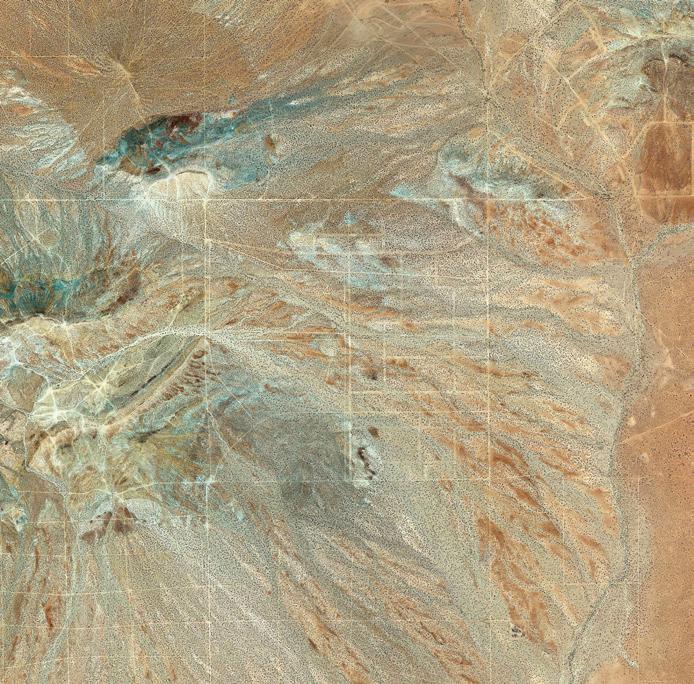
There is no better place from which to observe the geometry, geography, and geology of the planet than from a plane at several thousand feet. Glued to the window on a recent flight from New Mexico to Maine, I was struck by the designs below, inadvertently created by humanity through hard labor and greed, hope, and despair. It was a beautiful day, with cloud shadows racing across the land. The farther east we traveled the smaller were remnants of what we call wilderness – a bit depressing to a westerner accustomed to wider spaces. The sheer expanse of history and even geologic time is evoked as the land below us shifts and changes, as arid high desert and oil fields are replaced by wooded patches, as mountain ranges give way to plains, forests to farms, and streams to rivers (which sometimes resemble the historical roads they once were). Tiny dots dash along highways. Malls and subdivisions with an identical “variety” of architectural pastiche and curling culs-de-sac encroach on small farms. Scrawny thirdgrowth forests await yet another clear cut. There are pits and there are erections, skyscrapers rising from the terrestrial origins of concrete. And finally there is the persistent sea, eating away at the Atlantic coastline. Personal landscape revelations, such as the incredibly labyrinthine coastline of Chesapeake Bay with its mansions, marinas, and industries suggest new narratives for the non-native that are hidden from limited views on the ground.
But where am I? Aside from the occasional comments of a chatty pilot, I have no idea. A pilot friend gave me a flight map, but it doesn’t help much. The gap between print and fast-flowing visual experience is too wide. I have long wished for a streaming audio that would provide a map in real time as we careen over the continent.
Our cultural landscape can be parsed as a chart of political and financial power. Vast oil fields evoke outrage at the federal government’s ongoing environmental deregulations. Miles of circle-irrigated agriculture in the desert raise questions of water supply and waste. But from this exalted viewpoint there is little hint of the climate chaos already evident to those whose heads are not in the sands of leisurely beaches and golf clubs.


This is not the iconic image of a “whole Earth,” the lovely mottled marble seen from space. Despite the height from which peer down, it is a series of amazingly intimate views, dreamlike in their rapid disappearance, comparable to lived experience and fleeting memories. The abstract expressionist painter Joan Mitchell once said, “I carry my landscape around with me.” After spending a year in Devon, England, I found I could do the same, taking out-of-body hikes from Lower Manhattan across fields and hills and valleys that once knew so well and were now so far away.
Images © Google (2019).
As a writer obsessed by place, flights are both fulfilling and frustrating. Haunted by the visible geometries and geographies and invisible geologies, I wonder if there is a way to fuse our patterned views from above and intimacy with known landscapes below. Would that help us non-professionals to understand more about landscape architecture at its roots, to learn the lessons of the bird’s-eye-view? Scale presents an interesting problem. Miniaturization is too easy an answer, but landscape architects are equipped to conceptualize the fusion of aerial and ground views, and perhaps they will be crucial participants in public education around issues of climate disruption.
LA+ GEO/FALL 2020 79 78 WHAT ON EARTH?
Opposite: Landscapes across the United States.
Art Criticism, Visual Arts, Cultural Studies
B.W. HIGMAN
MAKING THE ROUGH GROUND PLANE
B.W. Higman is emeritus professor of the Australian National University and of the University of the West Indies. He has doctorates in history and geography. An Australian, he lived almost 30 years in Jamaica and has published widely on Caribbean slavery and landscape history. His work on the spatial concept of flatness began with an interest in the Jamaican lawn, spread to the flatness of the Australian continent, and grew into an even larger project, discussed in his book Flatness (2017).
History, Design, Technology
rossing rough ground, in the absence of clearly defined pathways, in unfamiliar territory, we choose our steps carefully. Nature’s landscape is unpredictable, the surface full of hidden hazards: protruding rocks, sudden declivities, slippery slopes, snakes in the grass. Its successful negotiation, indeed our very survival, depends on close attention to navigational clues, leaving us little time to appreciate the aesthetic qualities of the larger landscape. When walking in a “landscaped” place, by contrast, we expect few surprises, few risks to life and limb, and feel able to lift our eyes to contemplate the world around us – or safe to stare at the flat screens of our phones. We follow hardsurfaced pathways built into the design and, most of us, obey signs directing us away from the seductive softness of carpet-like lawns: “keep off the grass!” If we trip on an unexpected upraised paver in a public pathway, workers are dispatched to grind down the offending stone, or we sue.
At the base of this contrast is flatness, a spatiality rarely found in nature but essential to modern life. For many of us in today’s world, almost every surface on which we move, on most days, is a flat engineered technology; our feet barely touch the rough ground. Indeed, flatness is a concept and a condition central to the entire architectural enterprise, and a key to many other aspects of modernity. As an abstract concept, flatness is applied not only in the physical work of engineering—moving earth and pouring concrete—it is equally important in visualization and design, not merely enabling simplified mental maps but also supplying the tools and techniques needed to communicate ideas to clients, and to satisfy surveyors, regulators, and lawyers.
What is it about flatness that makes it so important and why does it have a special place in the spatial history of the modern

world? Broadly, the essence of flatness is invariance, a quality underpinning predictability and practicality, and contributing handsomely to profitability. In the modern world, flatness is valued for its reliable uniformity and relative lack of hazards, values that extend beyond the landscape to projects such as precision engineering and graphic design. These virtues spill over into concepts of social equality, justice, and fairness, exemplified by the level playing field. Yet flat landscape surfaces are often disparaged for their aesthetic blandness and baldness, their featurelessness, and indeed their emptiness.2
Negative perceptions of landscape flatness typically attach to broad vistas—deserts and plains—where topographic invariance can be viewed on a grand scale. These attitudes have something to do with the uncertainty of finding in such places the biodiversity needed to supply resources for survival, but also fears about getting lost in spaces lacking landmarks, going around in circles searching for waterholes or roadhouses. In contrast, local flatness is rarely disparaged or even noticed. In spite of these striking differences in landscape appreciation, one thing that is broadly common, whatever the scale, is a preference for pathways with surfaces as flat as possible to enable safe and speedy transit. Whether traveling through rocky mountains or across an arid plain, or simply negotiating a shopping mall, qualities of smoothness, straightness, and flatness are much to be desired. The modern engineered landscape caters effectively to these desires, ensuring efficiency and profit by constructing pathways that provide comfortable passage. Very often, these routes facilitate movement between diverse types of engineered sites—from home, to work, to shop—most of them, in turn, taking advantage of the profit to be made by building on a flat platform.
C
Focusing on movement and mobility offers a direct entry to analysis of the significance of flatness in landscape architecture, broadly defined, at all scales. It directs attention to the ways routes determine the flow of people—whether moving on foot, riding on animals, or driving wheeled vehicles—and to the impact on the landscape of these different modes of movement. Parallel to this flow of people is the movement of goods, often but not always sharing the same pathways and taking up increasingly large amounts of space. It is striking that wild animals also favor straight, flat routes so that, when roads or tracks are cut through forest, animals often use these as conduits, appreciating their practicality. However, pathways designed to suit human needs can have unintended consequences. Creating flat, direct routes may diminish protective natural barriers, channeling water into settlements. In addition to these physical and economic impacts, focusing on movement enables study of the ways travelers— locals and visitors—perceive and appreciate their surroundings. It also gives importance to the surfaces of routes—their shape, materials, textures—enabling an understanding of them as places in their own right (not non-places), essential elements of landscape. Broadly, then, movement brings to the fore both the aesthetic aspects of flatness and its fundamental practicality and profitability, and connects seemingly disparate landscapes and local ecologies.

The interaction between flatness and movement is important at every stage in the practice of landscape architecture, and has significance for the essential tools and techniques of the discipline. The process begins with visual flattening: the perception of flatness in the surfaces of existing topographies, and the evaluation and appreciation of such landscapes. What exactly it is that we see and whether our spatial images
constitute something “real”—out there, separate from our perception—is a question for neuroscience and philosophy, one that rarely keeps landscape architects awake at night. What should concern landscape architects, however, is the essential selectivity of our images and the ways they are complicated by relativities of time and motion. Visual awareness is fragmented and sequential. Rather than seeing landscapes as wholes, we pick and choose elements within the context of an abstract plane, flattened in the mind, and often unconsciously carried over into the design aspects of landscape architecture.3
Any transcription of the existing contents of a tract, whether large or small, is directed by an equivalent narrow focus—a flattening—determined both by perception and mission. The surveyor is always selective. For example, existing beaten paths, created by humans and animals, only sometimes leave clear visual traces and are therefore likely to be left off the plan. Equally significant, the representation of the elements within a tract of land, projected onto a sheet of paper, a canvas, or a flat screen, depends on the reduction of topographies to a two-dimensional state—making them plane—by means of cartography, painting and drawing, or photography.4 The process is perhaps most obvious in the case of the world map, in which our picture of Earth has come to be constituted by a brutal assault on the spheroid – its surface distorted and misshapen, flattened out to fit a sheet of paper or flat screen.5 Studies of landscape, from gardens to agroecology, geomorphology, and beyond, are rarely disturbed by the curvature of the Earth, and the principles are the same at all scales. Further, the warm embrace of GIS across a wide variety of fields and scales has ensured the longevity of cartographic flattening. Even when topography is represented by contour lines or perhaps 3-D
images, or displayed on a mobile wayfinding system, the final map or plan is presented on a flat surface.
Why are maps and plans flat? At base, the sheer overall practicality of flatness is a vital driver, facilitating the drawing of lines and enabling easy reproduction, enlargement, or reduction of efficiently stored plans. At another level, long before the invention of aerial photography, and working without surveying tools, human beings developed a capacity to picture the spatial relationships of landscape elements in their localities, and to transcribe these cognitive maps by drawing in (roughly flattened) sand or earth, just as they were able to draw (flattened) maps of the heavens. On the land, these abilities derived from long association with local topographies, known through the learning of wayfinding techniques and the linearity of routes. In walking or driving, it is most important to know where to turn and to look for landmarks and directional signs. Modern roads are littered with the latter but only occasionally refer to slope, as in “steep descent.” The symbol ↑ says straight ahead not ascend. Public botanic gardens offer similar signage to guide visitors through the landscape. Maps and plans perform much the same purpose, though more difficult for many of us to follow. Thinking of the negotiable world as flat seems quite natural, whether designed or not, as well as being functional and efficient. Creating routeways that are themselves flat reinforces the practicality of the enterprise though not necessarily the aesthetic experience.
Moving on from the visualization and representation of flatness to the creative design of landscapes, there is no doubt that the adoption of new technologies has transformed the practice of drafting. Before electronic devices took over around 1990,
technical drawing rested firmly on flat working surfaces— drawing table, light table, and (tilted) drawing board—and employed many flat tools—protractor, set-square, T-square, straight-edge, celluloid curves—to draw on opaque or tracing paper. The drawing tools themselves—pens and pencils—were rarely flat but were guided by the edges of devices laid flat on the drawing board or table. Freehand drawing and lettering liberated the draftsperson from these devices but the surface of the plan remained unrelentingly flat. Alternatives were hard to imagine. Three-dimensional models were made but perhaps more for exhibition and marketing than used to work out a design.
Electronic devices and architectural software packages swiftly made much of the traditional hardware redundant, yet the fundamental flatness of the process of design proved resilient. Flat screens are stared at and tweaked, typically in a 2-D image; while virtual 3-D models through which users may be led from space to space tend to remain the domain of promoters, as with the old technology, rather than being seen as essential tools in drawing up designs. Although computers have vastly increased their speed and capacity to cope with big data since the 1970s, they largely perform the same functions as in those heady days. However, the development of holography and 3-D printing point in new directions, toward multidimensionality, away from flatness. So does the recent adoption of georeferenced building information modeling (BIM), in which digital data are embedded in multidimensional models, not amenable to printing on a flat surface.6
On the other hand, in some respects, there has been a recent step back toward flatness, notably in graphic design elements, in response to the proliferation of smaller devices that demand
LA+ GEO/FALL 2020 83 82 MAKING THE ROUGH GROUND PLANE
simple graphics, often reflective of early 20th-century poster art with its undecorated flat patches of color. For some jobs, particularly those out of the ordinary, paper and pencil is recommended as the best starting point.7 Software packages are criticized for imposing drawing tools that predetermine concepts of space rather than opening up ambiguities; in other words, flattening the infinite possibilities in design, and creating a Cartesian straightjacket for the designer. Perhaps the flat screen together with the often extreme flatness of computerassisted graphics take on too much of the language of photography – once again with an eye to the glossy promotional image, encouraging a lively fightback by paper architects. What remains constant in this process of revolution and reaction is the steadfastness of the flat drawing surface, whatever the tools.8
Flatness is so essential to so many elements of the modern built environment that it is taken for granted. Thus it is not surprising that the ubiquity and persistence of flatness at every stage in the practice of landscape architecture—from the visualization and representation of existing landscapes to the drafting of new and renovated designs—builds on an unstated assumption that passages and pathways ultimately follow or float above an unseen foundational planar surface. In the landscape itself, beyond perception and imagination, the desire to make movement more efficient, profitable, and comfortable has been driven largely by wheeled devices, whether slow or fast. Wheels perform best on smooth surfaces and have limited tolerances to inclined slopes and sharp turns. The effect can be observed, for example, in the great lumbering harvesters that make their way slowly and steadily across laser-leveled croplands, and in high-speed trains from which travelers can barely catch sight of the surrounding landscape except for distant vistas. Laser-
levelers guide the blades of bulldozers; swatches of turfed grass are rolled out to create grassy carpets; concrete is poured and carefully smoothed and graded; pavers are set in sand to ensure the absence of risers waiting to trip the unwary walker; asphalt replaces cobbles finding its own liquid level. Roads, and their associated parking lots and domestic driveways, come to occupy significant areas, smothering the ground with concrete and tar, aggravating runoff, flattening and homogenizing everything in sight.9 When eventually in the 21st century landscape architects began to think unflattening was the way forward, particularly to relieve the uniformity of urban passages, it proved problematic, partly because of the cost but also because of the necessity of predictable surfaces underfoot.
Although flattening has played a positive role in the transformation of landscapes, the negative aspects of planarity keep creeping back in. The greatly increased ease and speed of movement, and the profits generated by new transportation technologies, must be balanced against the perception of the sameness—indeed the flatness—of modern landscapes. This apparent contrast reflects not so much a paradox as an underappreciated association between the abstract and practical appeal of flatness and the context within which it flourished. It was the factories, machine tools, steam power, and railroads of the Industrial Revolution that engendered much of this development, and contributed in the longer term to climate change. It was flatness that provided the firm foundations for factory floors and demanded fossil fuels for rapid transit, thus transforming the landscape outside the satanic mills, as well as within their walls.10
Landscape flattening became even more vital with the dawn of the Anthropocene, a geological period generally thought to

commence around 1945, when for the first time humankind shifted more earth than was moved by nature.11 Holes were dug and mounds raised up, but when it came to the construction of passages and pathways (and accompanying development) the typical goal of earthmoving was a flatter surface. However, the cutting of corridors and tunnels through steep land, to enable tolerably flat routes for motor vehicles and railroads, sometimes created conduits for the flow of water, enabling it to spread beyond existing physical barriers and creating level wetlands in times of flood. The experience is the same along coasts threatened by rising sea levels. Millions of people settled close to shorelines on flat “reclaimed” lands are now barely safe at high tide and becoming increasingly vulnerable to storm surges made more dangerous by the elevated temperature of warmed ocean surfaces. Sea level rise poses an even more dramatic threat—indeed an existential threat—to small, flat islands, condemned to a watery grave, hidden beneath the flat surface of the sea, their fate in part the ultimate outcome of global warming and the modern world’s love affair with everything flat.

1 These themes are developed in B.W. Higman, Flatness (Reaktion Books, 2017).
2 Kamni Gill, “On Emptiness,” Journal of Landscape Architecture 10, no. 2 (2015): 4–5.
3 Nick Chater, The Mind is Flat: The Illusion of Mental Depth and the Improvised Mind (Penguin Books, 2019), 39–46, 67; Graham Nerlich, The Shape of Space (Cambridge University Press, 1994), 263–68.
4 Christophe Schinckus, “Delimitation of Flatness in Painting,” Art and Perception 6 (2018): 67–75.
5 John P. Snyder, Flattening the Earth: Two Thousand Years of Map Projections (University of Chicago Press, 1997).
6 Yannis Zavoleas & Mark Taylor, “From Cartesian to Topological Geometry: Challenging Flatness in Architecture,” Nexus Network Journal 21 (2019): 5–18.
7 Elliot J. Gindis & Robert C. Kaebisch, Up and Running with AutoCAD 2019: 2D Drafting and Design (Academic Press, 2018), 549.
8 Sam Jacob, “Architecture Enters the Age of Post-Digital Drawing,” Metropolis, 21 March 2017, https://www.metropolismag.com/ architecture/architecture-enters-age-postdigital-drawing (accessed January 24, 2019).
9 John A. Jakle & Keith A. Sculle, Lots of Parking: Land Use in a Car Culture (University of Virginia Press, 2004); Christof Mauch & Thomas Zeller (eds), The World Beyond the Windshield: Roads and Landscapes in the United States and Europe (Ohio University Press, 2008); Francesca Russello Ammon, Bulldozer: Demolition and Clearance of the Postwar Landscape (Yale University Press, 2016).
10 Francis D. Klingender, Art and the Industrial Revolution (N. Carrington, 1947).
11 Roger LeB. Hooke, “On the History of Humans as Geomorphic Agents,” Geology 28, no. 9 (2000): 843–46.
LA+ GEO/FALL 2020 85 84 MAKING THE ROUGH GROUND PLANE
