10 minute read
Leonardo Piccini


Hot dry desert – on the map the area is coloured light purple. The La Venta expedition, numbering 17 speleologists, leaves Italy on 2 February, 2019, reaching Shiraz, capital of Fars Province, in the dead of night. At the airport we are met by Yones, an Iranian speleologist and friend, with the drivers of the minibuses that will take us around Iran. We load everything up and head immediately for Firuzabad, where it is still dark when we arrive. We are perhaps the only Western tourists in the city, and the locals are hospitable and curious. The first day is given over to organisation and shopping, and the next morning we split up into two teams and get going. One team will focus on the small dome of Khoorab, where the exploration of a resurgence last year came to a halt when faced with a bottleneck, and the other on Jahani, one of the largest Iranian diapirs, in part already explored by Czech speleologists. On this second diapir, after a number of attempts, we identify an unpaved road that comes close to the south-western flank of the mountain, which is yet to be investigated. The minibus clambers up to a square that was once used by bulldozers for the extraction of salt; from here, we overlook a valley that rises up to the plateau with steep, multicoloured slopes. We pitch our tents, and the first night we are surprised by the temperatures approaching zero. The stern expedition chief communicates the wake up time: 6 a.m. local every day, to make the most of the cooler morning hours. And every morning Antonio and I emerge at 6 from our tent, which is a little isolated from the others, only to find, time and again, all of the other members of the team
The ascent of the Nameki diapir, near the city of Lar
Advertisement
finishing their breakfast, the coffee having already cooled down. “How efficient!” I think to myself. Only at the end of the week do I discover that the time difference with respect to Italy is not two hours, as my watch had it, but two-and-a-half hours. However, every day we leave the camp before sunlight floods the valley. Salt clusters are covered almost everywhere by a several metre thick layer of insoluble deposits and detritus. On the side of the diapir and on the upland we find a number of sinkholes and hundreds of dolines, a few of which have promising black holes at the bottom, which make us look forward to unforgettable explorations. Over the course of three days, we descend into fifteen or so shafts, down to a depth of sixty metres. Invariably, though, the bottom is obstructed, with no indication of a way through; a situation very similar to that described by the CzechIranian team vis-à-vis the north-western sector of the plateau. We take the opportunity to visit Waterfall Cave – a through gallery at the end of a long valley that cuts through the highland, flowing into the south-eastern slope of the dome – before we meet up again with the other team at Firuzabad. On the Khoorab, Marco has placed his animal traps both inside and outside the cave; the exploration of the resurgence comes to an end shortly beyond the bottleneck, and a few small caves are added to the records we are compiling; nothing spectacular, though. On our day off, we decide what to do on the second half of the expedition. The other team heads for Lar, 200 km to the south-east, where they will meet the local authorities, and together with the local caving group they will climb the nearby Nameki diapir, exploring
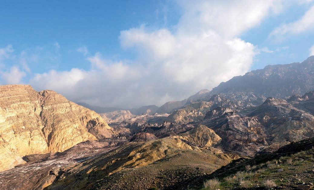
a pair of shafts. Our team will reach the coast of the Persian Gulf before making our way back up to the Kuhe-Namak in Dashti. “Hot dry desert”: on the map the area is coloured light purple…will we ever find the great salt cave? During the night, on 13 February, 2019, the bridge over the road that links the town we are staying in to the coast is submerged by the river flood, but our minibus has now resurfaced. It’s been pouring down for two days. The first expedition, last year, had had to deal with the oppressive April heat, so this year we pulled the departure forward. Today we will get supplies in the town on the other side of the mountain, as we wait for the weather to get better. Before the mountain became off-limits, Luca 1 and Luca 2 in our party had finally discovered the cave. Kuh-e-Namak, the Mountain-of-Salt in the district of Dashti, not far from Hormuz, is utterly spectacular. In contrast to many other salt domes, here the salt surfaces almost everywhere on the mountain. The effect is remarkable: the salt, combined with grains of the insoluble detritus that it transports along with it, forms densely alternating bands in various shades (honey, ivory, black, sand). These are set against a landscape with sharp, jutting crests that delineate small valleys, while the twisting valley floor is marked by white strips of pure salt. On the horizon, we can make out the large central panettone, which indicates the location of the mouth, the “fountain”, from which the salt has arisen, boring through the embedding rocks to emerge on the surface after an upward-thrusting journey of 5-6000 metres. This extraordinary diapir is amongst the most active in Iran. It is estimated that the salt comes out of the mouth of the fountain at the exceptional speed of 17 centimetres per year, and that of these a full 11 are then dissolved by the water of the albeit rare winter rains. Every year, half a million tonnes of salt, dissolved by the rain, is carried away by the torrents running both above and below the surface. Impressive quantities of salt, with a thickness of hundreds of metres, were deposited by evaporation on the sea bed of this region between 500 and 600 millions of years ago. Thousands of metres of other deposits have subsequently buried the salt. Squashed under rigid, dense rocks, it was during the Cretaceous period (70 million years ago) that the lightweight, mouldable salt finally found the right fault to emerge to the surface, like volcanic lava, and to form the first Kuh-e-Namak, many millions of years before the formation of the undulating Zagros mountains. It is not known whether the extrusion of the salt has continued since then, but in any case, the salt dome today rises 1400 metres above the surrounding flatlands. A few days ago, we split into two groups, to attack the diapir from the plains to the north and the south. The cargo bed of a 4x4 takes us in the northern group close to the first salt outcrop. To the left and right of the central panettone, deep valleys separate it from the adjacent calcareous-arenaceous mountains. Near where we are, the salt has dripped from the fountain onto the surrounding rocks, covering them like a “glacier”; due to its similarity to this phenomenon, the salt was at one time also referred to as a glacier. More recently, a specific term has been coined for these salt formations: namakiers, a word deriving from namak, which means ‘salt’ in Farsi. The namakier, too, flows slowly, filling up valleys and passing over crests, transporting blocks and detritus before coming to an end on a front surrounded by deposits that seem to be moraines. From the plain we head back into the white bed of a valley and divide up into two squads. Francesco, Giovanni and I climb the namakier to the left. The route is uneven and we make our way across areas of sharpened blades carved out of the salt; it is a beautiful day and the landscape is spectacular. We ascent to the base of the walls of the central dome, but there are no
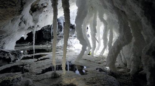
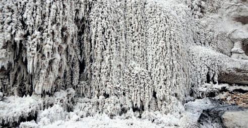
Salt waterfall in the northern namakier Kuh-e-Namak
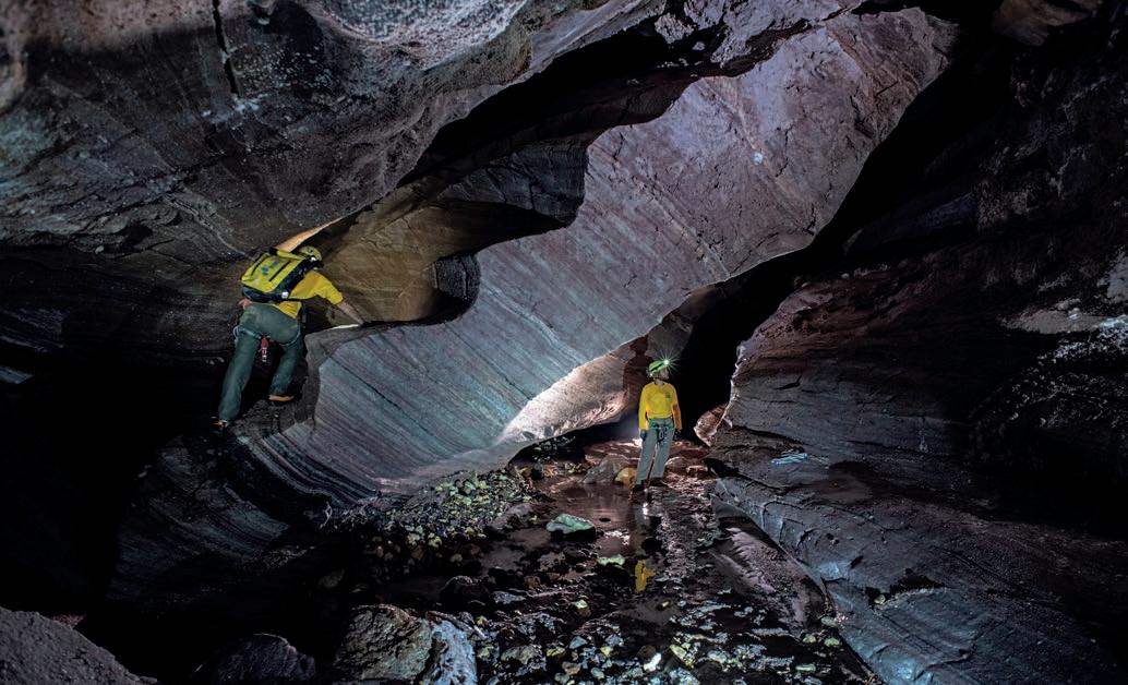
caves to be found. The route back takes us through valleys, walls of salt and narrow gorges, until we come to a final cascade of white salt that reaches the valley floor separating the diapir from the adjacent mountain. On the waterfall it really feels like being on a Patagonian glacier, and I can almost feel the absence of crampons on my feet. At the same time, a little further north, at the base of a limestone plate that emerges from the namakier, Luca and Luca bathe their feet in a river that disappears into a salt cave... The first look around allows us to establish that this is a large cave. The next day, Luca, Luca, Francesco, Gaetano, Mattia and Tommaso follow the underground river, amid little lakes and small drops, for around one kilometre. In the meantime, with Antonio, Giovanni and Leonardo we move even further north and discover an entrance, at the base of a little hill of salt, resting on the embedding limestone and isolated from the rest of the namakier during the course of the final retreat of the saline front. Yes, because like glaciers, namakiers, too, can advance or retreat. It depends on
how much salt emerges from the fountain and on how much is dissolved by the rainwater. The hill of salt is only one hundred metres long, and we cross it from one side to the other in an excavated gallery in contact with the limestone substrate. The day after, the torrential rain begins again, forcing us to twiddle our thumbs. The precipitation over these two days corresponds more or less to the normal annual total, which according to the data recorded over recent decades should be 280 millimetres. “Iran is experiencing unprecedented climate-related problems”, with extreme events of exceptional aridity but also unusual rainfall and floods, the like of which had been unknown in this region – that is what was reported by Iranian researchers in a recently published article. It is possible that the effects of global warming are responsible for the strange climatic conditions we have run into. During most of the year, the salt is dry and deforms easily. Water, on the other hand, makes it less viscous, causing it to slide; during the strong rains, and so probably only for a few days a year, the salt travels at an estimated average speed of half a metre per day. In the meantime, for its part, the South group has been busy too. The two Giuseppes, with Vito, Gaetano, Alessandro, Diego and Yones, have discovered and explored a system of underground galleries, set along a valley, alternating with segments of epygean gorge, on a path extending for a kilometre. Other caves are being explored. The weather has calmed down. On the last full day of the expedition, we all ascend to the highest entrance of the Namak River Cave, the “Cave of the River of Sand”. The descent is thrilling, in a gallery full of meanders, between walls with coloured banding and stalactites of white salt. The torrent flows on down, apparently indifferent to the presence of the cave, and in some sections there is no roof to the gallery, the light penetrating the gorge. The features of the gallery recall those of the Perito Meccanico, the cave that we explored in 1995 in the Perito Moreno glacier in Patagonia. The Namak River Cave extends for just a few metres under the surface of the topography: every now and again, the roof has collapsed, opening the gallery up to the outside world. We walk through the river with the water at times up to our waists (it’s not cold here, though!), with a few drops that break the slope of the profile. As we head down, we carry out the survey, taking photographs and shooting some video. At the end, we come out of the gorge on the front of the namakier.
Participants Gaetano Boldrini, Leonardo Colavita, Giuseppe Giovine, Luca Imperio, Marco Mecchia, Giovanni Rossi, Tommaso Santagata, Giuseppe Savino, Mattia Bernabei, Vito Buongiorno, Luca Bussolati, Marco Isaia, Gaetano Proietto, Francesco Spinelli, Antonio Trocino, Alessandro Uggeri, Diego Zanzi, e l’amico iraniano Yones Shariatmadari.
Bibliographical references Talbot C.J., Jarvis R.J., 1984. Journal of Structural Geology, Vol. 6, pag. 521-533. Vaghefi S.A., Keykhai M., Jahanbakhshi F., Sheikholeslami J., Ahmadi A., Yang H., Abbaspour K.C., 2019. www.nature.com/scientificreports. Talbot C.J., Pohjola V., 2009. Earth-Science Reviews, Vol. 97, pag. 167–195. Abirifard M., Raeisi E., Zarei M., Zare M., Filippi M., Bruthans J., Talbot C.J., 2017. International Journal of Speleology, Vol. 46, pag. 445-457.