11 minute read
Kermanshah - Iran - Northern Parau expedition 2017 - 2018


KERMANSHAH – IRAN - NORTHERN PARAU EXPEDITION 2017 – 2018 Gianluca Selleri, Alfredo Brunetti
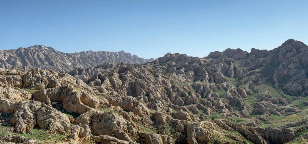
Severe, jutting mountains, limestone pavements and seemingly bottomless holes in the rock, the Persian nights illuminated by the military forts that guard the mountain passes: we are back on the northern Parau massif in Kermanshah Province, at the edge of the Iranian Kurdistan and less than eighty kilometres from the border with Iraq. In purely human terms, the second La Venta expedition to Iran was a unique experience whose powerful, penetrating sensations have left an indelible mark on those who participated. It is difficult, actually, to think back to the mountains of the Parau and simply envision the brutal ruggedness of the high plateaus, the plunging shafts with snowfields, the caves. You cannot help but experience again the colour of the massif, the dusty dryness of the air that burns your lips and nostrils, the view from the camp overlooking the limestone mountains and valleys behind it – a landscape of countless well-defined and thus-far unexplored dolines – the unexpected deliciousness of the food, and all the sensations that things such as these reawaken in the mind. Just as insistent is the memory of our Iranian companions, their combination of coarseness and civility, warmth and formality, stubbornness and deference. And the caves? The Parau – that extreme offshoot of the Zagros Mountains – surely induces the same effect in every speleologist, a spellbound captivation, like a child
Advertisement
Landscape of Mount Kuh-e Parau
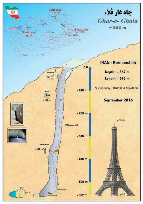
on a trip to the funfair. The vastness and ruggedness of the limestone pavements with their countless unexplored swallow holes, the monstrous Qala Cave, which drops down to 563 m, the crystalline hues of the lake at the bottom of the Gholan Shaft and the beauty of the concretions in the recently discovered Ghizhalan Cave: it is a spell that is impossible to escape, that represents the real reason that we have returned to these half-unknown mountains and attempt to shed some light on an even greater part of the vast darkness they harbour in their depths. The Ghala Cave is an exceptional geological phenomenon, a huge natural chasm that opens at an altitude of around 2,800 m and reaches down some 563 m towards the heart of the Parau massif. Around 400 m from the mouth is a terrace of enormous blocks, where a trickle of daylight is still visible. It is formed from an unstable cone of fallen detritus that has got caught in the shaft, and overlooks the final section of the cave. Those who wish to reach the large chamber at the bottom face a dangerous descent. At the foot, they will find a stretch of mud leading down to an underground lake, which is fed by the incessant dripwater and an underground stream at the bottom of the shaft. As part of this expedition, the first professional photographs were taken to document the cave. The mouth of the Ghizhalan Cave (current known depth 450 m) opens at an altitude of approx. 3000 m
above sea level. At the foot of the huge entrace shaft, at a depth of around 120 m, there is a bank of snow and two branches: a large, twisting passage with an initial drop of about 20 m still unexplored and a passage formed in a phase of rejuvenation that, albeit more modest in size, had obvious air currents that immediately attracted our attention. At a depth of -350 m the shaft splits on one side is another tight passage formed by a rejuvenation phase that extends for a few dozen metres via narrow tunnels and small drops until it reaches yet another, half-flooded narrowing. On the other, there is a fossil branch that, after 20 m, descends into a large shaft around 80 m deep with wonderful concretions on the walls. At the bottom the meandering passage continues, wide and covered by calcite croncretions, with drops as it makes its way downwards to another pit where previous explorations were halted due to a lack of equipment. The huge size of the massif, together with the lack of water and the harsh environmental conditions made surveying from above ground particularly challenging. All the same, we managed to form some idea of the wealth of opportunities hidden within these ancient mountains. During the survey several cave entraces, literally riddling the plateau, were identified at altitudes between 2,800 and 3,100 m. It was only possible to probe a few of these shafts, which were found to range from a few dozen to 70-80 metres in depth, although GPS positions were recorded for many of the others [G.S.]
Winter 2018: “Listen, fancy a trip to Iran? If you do, call Spit and he’ll explain.” At the other end of the line is Leonardo Colavita. “OK,” I blurt, “give me his number.” A trip to Persia? Why would I need to think about it? The enthusiasm I had already harboured for that wondrous land of ancient history, enchanting landscapes and huge speleological potential had been fanned by tales of La Venta’s work from two years earlier. Seven of us set off from Italy, arriving in Tehran in the early hours of the morning where we negotiate the far-from-straightforward matter of getting through customs. The economic difficulties faced by the country in the wake of the questionable sanctions imposed recently by the United States are immediately apparent as we are literally besieged by countless “merchants” who offer to change our money at a rate three times what it had been just a year ago. All this in a place where credit and debit cards are virtually impossible to use. Fortunately, our Iranian colleagues are there to welcome us and restore our spirits with smiles, delicious sweets and the inevitable cups of tea. We pass the next few hours waiting for our other colleagues, who are joining us from Poland, Spain and Armenia, another reminder of the international nature of the project.
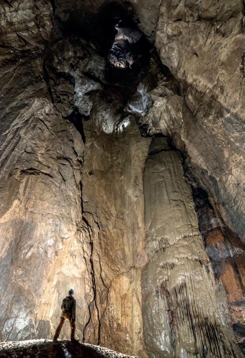
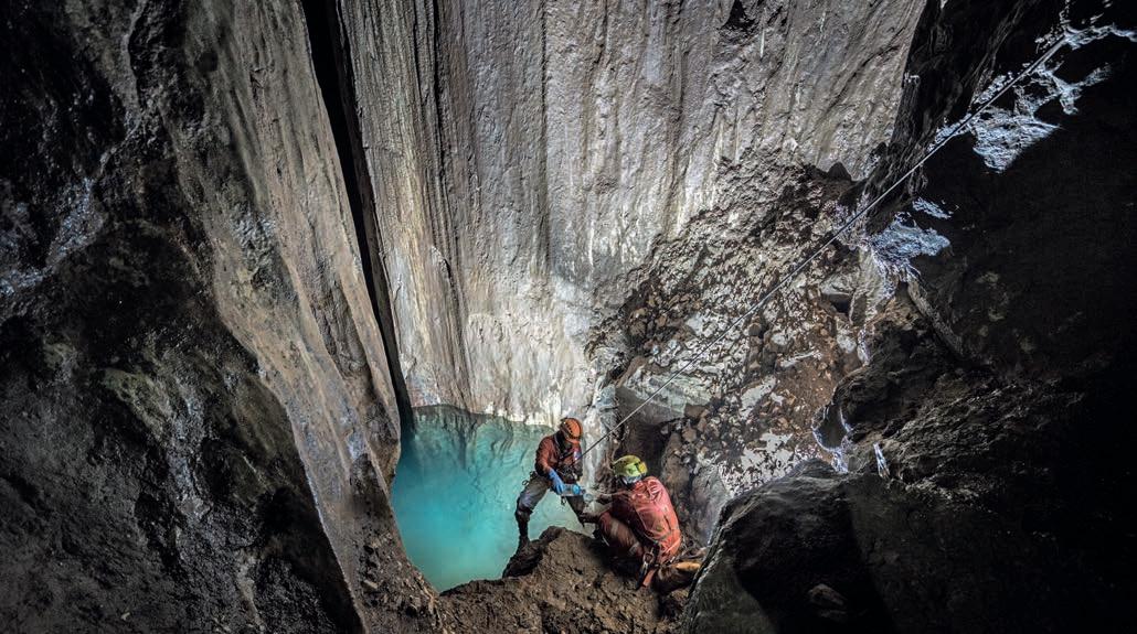
The last 200 m of the Ghala Cave
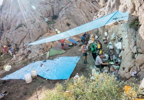
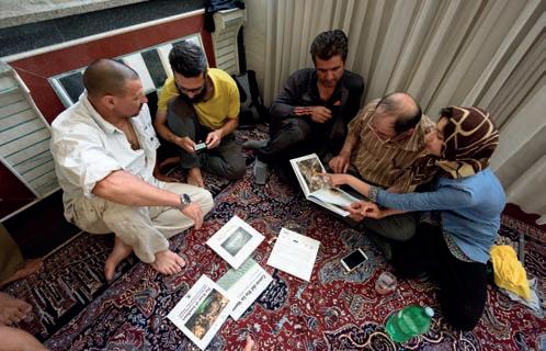
Brief rendezvous in Kermanshah with exchange of books
With the team reunited, we set off westwards travelling comfortably by coach for around 600 km. The tiring journey begins to take its toll, but I am so curious to see this land – this meeting point of civilisations and religions – that I manage to stay awake for long sections. Finally, we reach Kermanshah and the home of the gracious Mahdi – brother of the mission leader Youssef Sorninia – where we experience Iran’s proverbial hospitality for ourselves, sipping tea on comfortable rugs. For some, it is also a chance to greet friends with whom they shared memorable moments during the explorations of the previous year. We pass the first day sorting out our equipment and purchasing our final supplies at the local bazaar, where we are immersed in a kaleidoscope of colours, sounds, smells and flavours. Westerners are an unusual sight in this part of the city, and we are frequently stopped by local youths who take photos and ask us questions in broken English. The following day, long before dawn, we begin our journey to the summit of the Kuh-e Parau massif, which overlooks the city of Kermanshah to the west. As in previous years, to reach the rest of the group and our equipment, we foreigners are required to make the roughly three-hour trip along the valley, thus avoiding the military outposts. The first section of the approach is pleasant, in any case, cutting through canyons and small villages that are either inhabited or empty depending on the time of year. Close to a number of small springs, we come across the dwellings of nomad herders, who watch us curiously as we pass. For a moment, it feels like time hasn’t passed here for centuries. Our route covers over twenty kilometres, with a vertical displacement of almost a kilometre and a half. We only reach the plateau, at 2,800 m, late in the evening. Here, we set up our base camp close to the Gholan Shaft (“the water cave”). Objectively, the logistics of the camp are not a straightforward matter, and I can’t deny having more than a few concerns when we arrive. Will there be enough food for the duration? Even more importantly, will we be able to find enough water for what will turn out to be a group of around 30? This is an extremely arid area, and my dry lips and burning throat do not bode well. Fortunately, my concerns are immediately swept away by the impeccable preparations of our Iranian friends: the camp kitchen is run expertly by the admirable Alì, and we take turns descending the 130-m well of the Gholan Shaft to collect ‘blue gold’ every day using a winch. The meticulous Youssef has also planted carefully hidden bottles and jerry cans of water around the surrounding area, which can be used in case of emergency. These will turn out to be invaluable, as we will discover in the days to come. The morning after our arrival, with our legs still stiff from the long journey, the first team hurries to the Ghizhalan Cave, where they will re-rig the initial section and, more significantly, push on further with the exploration. Back above ground, other members of the team deal with retrieving the remaining equipment from the plateau at 2,300 metres, and the tricky business of collecting water. Negotiating narrow, half-flooded tunnels, small drops that will need to be free-climbed on our ascent, and the never-ending, omnipresent mud, we move quickly to
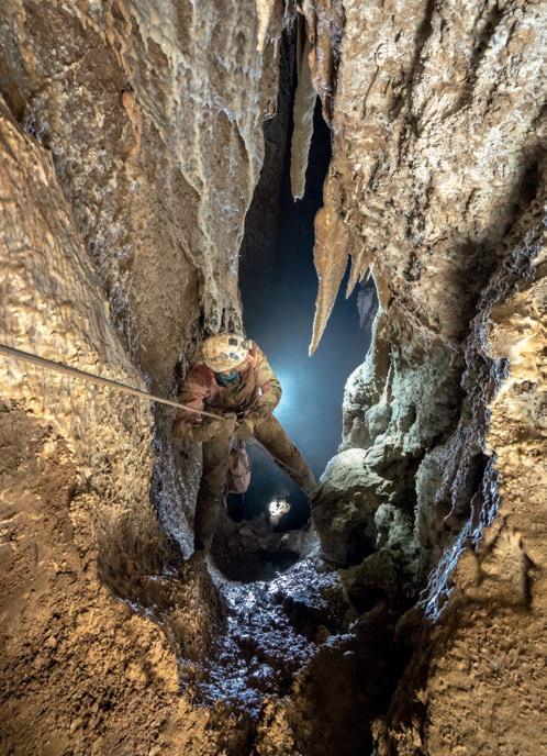
Ghizhalan Cave at the start of the well, 80 m wide and around 350 m deep reach the shaft 450 m underground where the previous year’s exploration was halted for lack of equipment. We reach what has been described to me as a 20-metre pit, but as soon as I lean over the edge, I have the feeling that it is not as advertised: I can’t make out the bottom by the light of my head lamp. We climb down what is actually a shaft of 80 m, and it is clear that the cave continues even further! In the following days, during several descents, we reach a depth of 700 metres, an impressive result that makes this recently discovered pit in the Parau plateau the third deepest cave in Iran. Our only regret is that our Iranian companions are not able to join us in the exploration, as they are busy running the camp, the only exception being a couple of sorties by the inspiring expedition leader, Youssef. Despite the decidedly unfavourable conditions of this wonderful, Martian landscape, we manage to carry out a number of new and fruitful exploratory excursions, investigating some of the entrances identified the previous year and locating new entrances, as well as collecting samples for scientific projects conducted by Iranian friends at local universities [A.B.]
Ghala Cave (from one of just a few diary entries) “It’s my day off, and I am in my tent tired, with cracked lips and sores in my nose that won’t give me peace. I have tried everything I have been recommended to protect the mucous membranes, but it has been a miserable failure. The explorations have gone really well, and our above-ground recon has confirmed what we suspected from a first look at the terrain. There is enough exploring here to keep us busy for years. We are just a few hundred metres from what is currently the second-deepest single shaft in the world. I should probably take a look! I get ready quickly, and after our usual, hearty and delicious breakfast prepared by the untiring Alì, I ask Youssef for an update on the descent schedule he has set up. You can’t just decide for yourself to make the descent, Youssef has made this perfectly clear, so I am happy to discover that everyone else has already done it and there are spaces for those who haven’t managed to visit the ‘pit’ because they have been busy with other explorations. Joining me will be Mirko, who is as excited as I am about this opportunity, not least because it will give us a sort of ‘advanced-speleologist’ status. For Youssef, the descent to the bottom of the Ghala is a kind of test for members of his caving group, of which we are now unofficial members. Only those who dare to test themselves against the 562-m descent will make the grade: another reason, as if it were needed, not to pass up the opportunity. We make our descent slowly, enjoying the beauty of the enormous chasm with its hanging snow banks and the echo of birdsong. The decision to take it slowly will also be rewarded on our ascent, as we have the sun providing light as deep as -350 metres and giving us a new perspective on our majestic, magnificent surroundings that our head lamps were unable to provide.” [A.B.]
Participants (2017-2018)
Yousef Sorninia, Naser Raznahan, Younes Shariatmadari, Ali Daychin, Afshin Ahmadinejad, Saeid Mohammadi, Hosein Frouzandeh, Hossein Shahiri, Majid Abdollahi, Mehdi Shomali, Jamal Ghorbani, Mohammad Khalizadeh (Surena Caving Team, Tehran); Alvaro Perez Martinez, Ferriol Canyelles, (Spain); Johan Boccarossa (France); Alfredo Brunetti, Umberto del Vecchio, Francesco Ferraro, Mirko Meneghini, Alessandro Rinaldi, Alberto Romairone, Alessio Romeo, Gianluca Selleri, and Giuseppe Spitaleri (La Venta).
Acknowledgements
We wish to thank our friends Younes Shariatmadari of the Iranian Cavers and Speleologists Association (ISCA), Yousef Sornina, Javad Nezamdoost (President of the ICSA), and all our other friends from Iran who have provided assistance. Our thanks also to Shiraz University, the Speleology Society of Lar (Iran) and the regional authorities who granted us access to the mountains and cave sites.
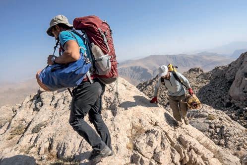
Hiking towards Ghizhalan Cave


