
10 minute read
Issues & Opportunities 2.0


2.1 Existing Conditions
Existing conditions for Cardinal Valley were collected, analyzed and mapped through GIS data, a windshield survey conducted in the fall of 2014, observations during site visits, and a walking assessment completed by the Planning Team.
2.1.1 Land Use
The map on page 17 shows how land in the study area is currently being used.
• The study area is composed mostly of singlefamily residential, also known as low density residential.
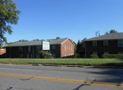
• Most of the multi-family development (medium and high density residential) is concentrated along Village Drive, Cambridge Drive and south of Versailles Road.
• Major institutions include Cardinal Valley Elementary School, Lexington Public Library Village Branch, Cardinal Hill Rehabilitation Hospital and several churches.
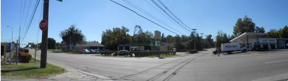
• The majority of the commercial area is along Versailles Road and Alexandria Drive, with a few businesses in Oxford Circle.
9% PARKS/OPEN SPACE
2% OFFICE/PROFESSIONAL SERVICES
1% MIXED-USE
21% HIGH DENSITY RESIDENTIAL
9% COMMERCIAL
3% LIGHT INDUSTRIAL
8% SEMI-PUBLIC/ INSTITUTIONAL
10% MEDIUM DENSITY RESIDENTIAL
37% LOW DENSITY RESIDENTIAL

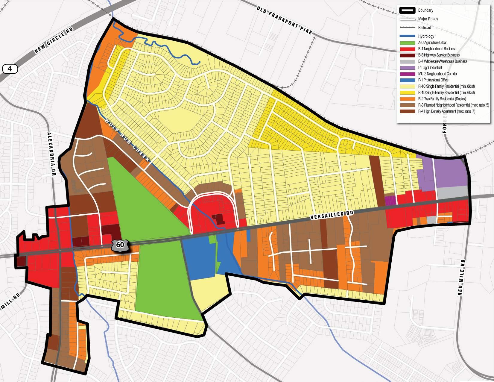
2.1.2 Current Zoning
The Map at right represents how land in the study area is currently zoned and regulated.
• Most of the study area is zoned as SingleFamily Residential.
• Parcels zoned as Business are concentrated along Versailles Road.

• Parcels zoned Light Industrial are located on the eastern portion of the study area.
• The Agricultural-Urban zoning designation was originally intended to control the development of rural land within the Urban Service Area over a period of time so as to manage the growth of the community. In this particular case, the Hillcrest Memorial Cemetery and a private residence make up the majority of this zone on the map.
Office
2.1.3 Neighborhood Retail + Community Services
The study area contains a variety of neighborhood retail and community services. The map on the right shows the concentration of these services along Versailles Road, particularly Oxford Circle, Alexandria Drive and along the Light Industrial Zone.
• Alexandria Drive hosts a variety of local Latin restaurants and miscellaneous retail.

• The majority of locally run businesses are located in shopping plazas.
• Nationally franchised brands and chains, such as Starbucks, Taco Bell, and Little Caesars are distributed along the Versailles Road Corridor.


2.1.4 Pedestrian, Bicycle, & Recreational Assets
Cardinal Valley is surrounded by various recreational areas, including parks, creeks and natural springs, as well as a crisscrossing network of pedestrian facilities.
• Valley Park is heavily used by the community for a number of events and sports such as soccer, festivals, ballet, softball, knitting, plant sales, book festivals, among others.

• Preston’s Springs Park is a natural spring located on the northern edge of the study area. It remains largely untouched. Better pedestrian access is needed to make it more accessible for the community.
• Wolf Run runs north to south within the study area, serving as backyard scenery for single and multi-family homes. Largely underused, Wolf Run can serve as a trail connector to link some of the open spaces in the neighborhood.
• Bicycle facilities in the form of bike lanes, are present along one section of Versailles Road, from Alexandria Drive to Oxford Circle, within the study area. Outside of that section no other bicycle facilities currently exist within the study area.
• Sidewalks exist throughout the neighborhood, but there is a connection issue when it comes down to the sidewalk network extending to Versailles Road.
• There are also numerous crosswalks or ADA ramps at intersections that are in need of improvements or do not exist at all.

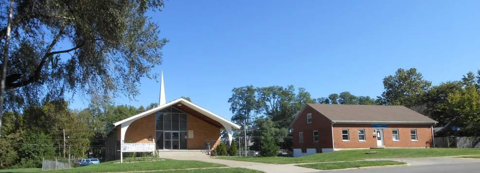
2.1.5 Health Assets
The study area has an abundance of health assets ranging from rehabilitation centers and nursing homes to substance abuse programs and homeless shelters.
• Cardinal Hill Rehabilitation Hospital treats patients recovering from strokes, spinal cord injuries, brain injuries, and acute trauma injuries.
• Hope Center for Women cares for homeless and at-risk women.
• Chrysalis Family Program is a substance abuse treatment program for women.
• Homestead Nursing and Rehabilitation Center is a nursing care center serving the rehabilitation of injured, disabled, or sick persons.
• HealthFirst Bluegrass Clinic (proposed) will be a quality medical, dental, pharmacy and support services for all members of the family, from newborns to elderly patients, and all ages.
FIG. 2.5: HEALTH ASSETS
2.1.6 Street Network
Due to the time period the neighborhood was planned(1950’s/1960’s), the study area is heavily influenced by vehicular traffic, resulting in curvilinear streets ending in cul-de-sacs. In addition to that, the grid is disconnected by both manmade barriers, such as the Versailles Line railroad corridor, Versailles Road, and New Circle Road, and natural barriers, such as Preston’s Spring and Wolf Run. This becomes difficult to navigate through for those not familiar with Cardinal Valley. Having a connected pedestrian and vehicular neighborhood augments the quality of life and allows easier access to local amenities.
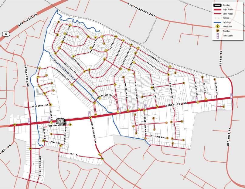
8 Signalized intersections on Versailles Road

53 T-Intersections
28 Dead End Streets and Cul-de-sac
2.1.7 Transit Network
Lextran has five routes that provide bus service within the study area. Three of the five (Route 8, Route 21, and Route 31) enter the heart of the study area while the other two (Route 12 and Route 15) only exist on the eastern boundary. Route 8, Versailles, and Route 31, Alexandria Crosstown, provide service in the central and western portion of the study area along Versailles Road, Oxford Circle, Cambridge Drive, Village Drive, Devonport Drive, and Alexandria Drive. Route 21, Airport / Keeneland, provides service along Versailles Road through the study area.
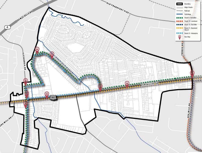
• Based on the productivity of Lextran’s 23 bus lines in March of 2014, Route 8 was Lextran’s most utilized route.
• Route 15 was #8 on the overall list with significant ridership from the University of Kentucky
• Route 12 was #13.
• Routes 21 and 31 showed low ridership at #20 and #23 respectively.
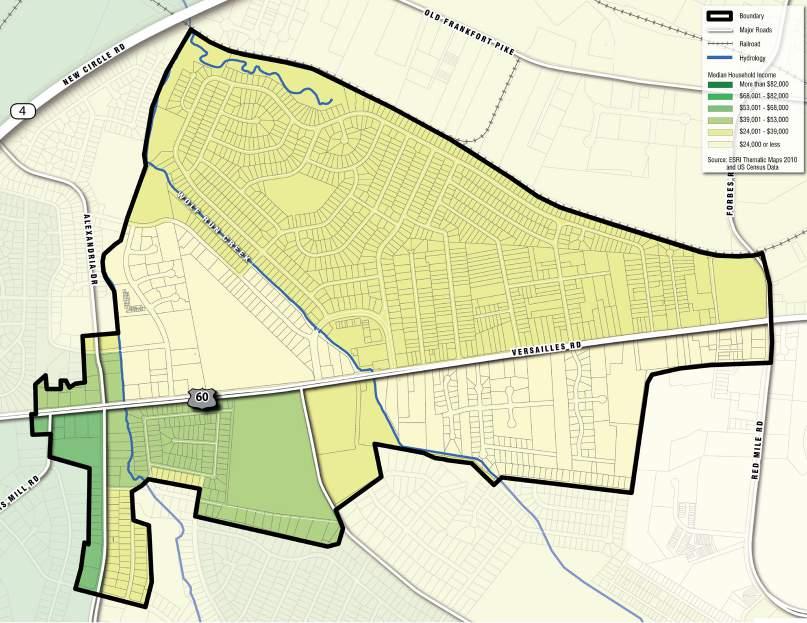
2.1.8 Median Household Income, 2010
A median income is the midpoint in a range of numbers. Household income is measured by the person(s) residing in the same household. When compared with the average household in Lexington, it is telling of the income disparity between Cardinal Valley and the rest of the city.
• The majority of the single-family residents make between 24k-39k
• Most of the residents that make 24k or less reside in the areas designated for multi-family.
• More than 90% of the study area has an unemployment rate between 7.1%14%. $ $ $
How does the median household income in Cardinal Valley stack up to elsewhere?
United States $53,649 Kentucky $42,802 Lexington-Fayette County $49,421
2.1.9 Population Change, 2000-2010
A Population Change map can show where residents are moving to or investing in. As the map on the left demonstrates, most of the growth is centered on the southern part of the study area, around new and growing multi-family apartments, as well as growth in the southeast with the increase of single-family homes.

There is some moderate growth around the single-family neighborhoods surrounding Cardinal Valley Elementary School.
Lots of Growth
Moderate Growth
No Significant Change
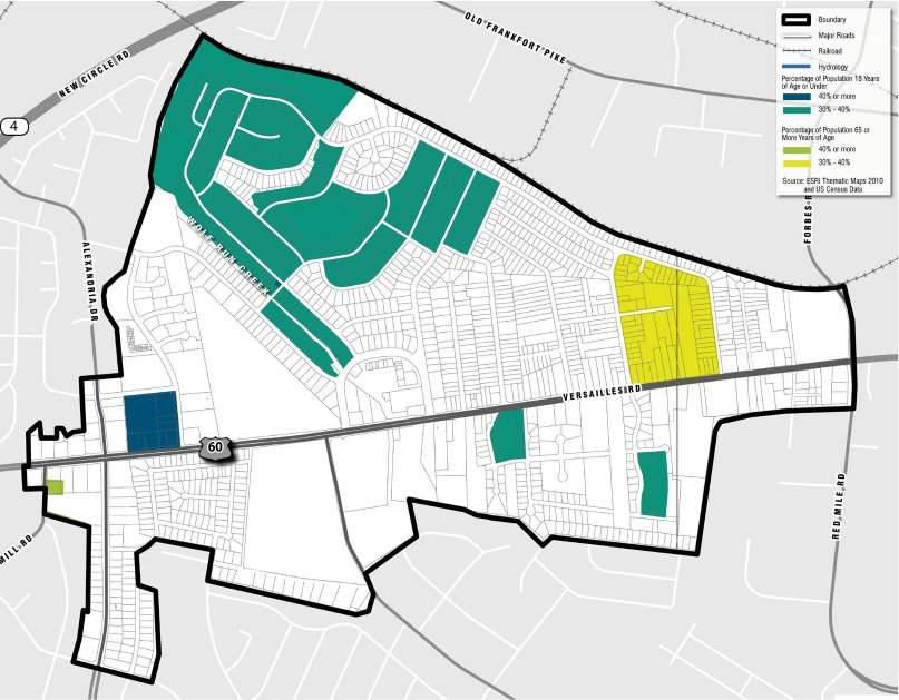
2.1.10 Population Under 18 and Over 65, 2010
Understanding where the majority of the younger and elderly population reside, as well as the age distribution can help plan for more adequate amenities throughout the community.
UNDER 18 YEARS OLD
65 YEARS OLD & OVER
18-64 YEARS OLD
Median Age = 23.3 Years Old
Young Families
In the single-family neighborhoods around the elementary school
Senior Citizens
In the area around Christian Towers
2.1.11 Housing Occupancy, 2010
For the Cardinal Valley Study Area...
For all of Lexington-Fayette County...
12% VACANT
9% VACANT
88% OCCUPIED
... out of 5,656 residential units.
91% OCCUPIED
... out of 135,160 residential units.
2.1.12 Housing Units, 2010

The map on the right shows the number of housing units per Census Block group. It helps identify where the highest concentration of housing units occurs within the study area. The multi-family apartments, shown as the darker brown colors exist mainly along the western and southeastern sides of the study area. A housing units map can help identify areas where public amenities would be most beneficial to serve the greatest portion of the community.

2.1.13 Housing Mix
The map on the left shows the concentration of single-family homes on the northeast side of the study area. Multi-family and duplex housing are located on the northwest, southwest and southeast sides of Cardinal Valley.
FIG. 2.12: HOUSING MIX
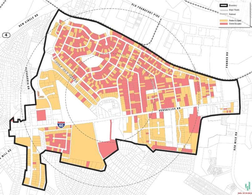
2.1.14 Housing Tenure
A housing tenure map shows where the renter and owner occupied homes are located within a neighborhood. The map can also provide an idea of the investment the community is making. For example, having a large amount of owner-occupied single-family residences is a good indicator of the long-term vision for that area. As the map on the left demonstrates, there is an even mix of renter-occupied and owner-occupied homes.. As is typical, the multi-family and duplex homes are primarily renter-occupied.

2.1.15 Housing Value
A housing value map demonstrates what areas in a neighborhood have the lowest, moderate, and highest housing values. Within Cardinal Valley, the single-family residences on the north of Oxford Circle have the lowest housing value, while the single-family homes southeast of Versailles Road have a mix of moderate to high housing values. The majority of multi-family and duplex homes located northwest and southwest within the study area range in price value from moderate to high.
2.1.16 Patterns of Investment & Disinvestment, 2010-2014
Investment maps show if and where the community is interested in investing. Within the past five years, Cardinal Valley has seen an investment along its main commercial areas, Alexandria Drive and Versailles Road, and scattered throughout the neighborhood. The yellow parcels in the map on the right show property where a building permit has been requested. The question is not how to get business owners to take interest in the neighborhood, but how to keep encouraging further investment opportunities.


2.1.17 Natural Features
The study area has a varied topographic profile, with its highest elevations located primarily on the southeastern region. The highest points of elevation can be found on the site of the Cardinal Hill Rehabilitation Hospital, part of the eastern portion of the single-family neighborhood, as well as the area southeast of Versailles Road. Cardinal Valley is comprised of one main waterway, Wolf Run and its tributaries, that runs along the center and western portions of the study area and makes up the lower lying areas. Steep slopes exist along the northern edge of Preston’s Spring and along Oxford Circle and are a natural restriction to development of those areas. These areas will also need to be kept vegetated to avoid stormwater runoff from becoming a greater issue.
FIG. 2.16: NATURAL FEATURES
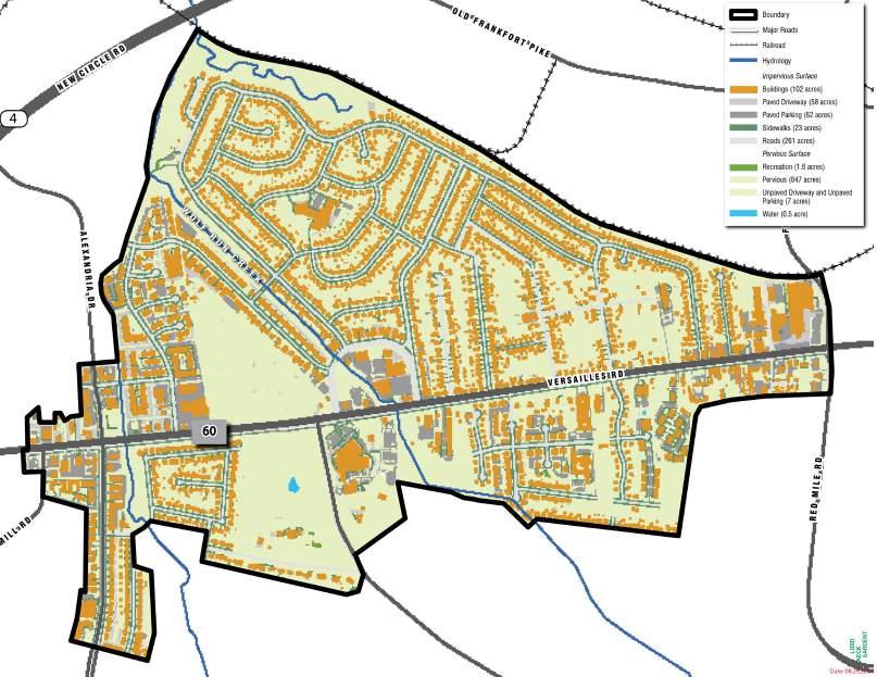
2.1.18 Land Cover
More than half of the study area is composed of some form of pervious surface (63%), while a majority of the impervious surfaces are concentrated on the lower portion of Cardinal Valley, along the Versailles Road Corridor, specifically around the commercial and multi-family development.

2.1.19 Tree Cover
Having a substantial amount of tree cover offers numerous economic and environmental benefits. For example, it helps improve air quality, provides an aesthetic quality, reduces stormwater runoff and heat island effects, and enhances property values for both residential and business areas. As the map on the right shows, most of the tree canopy is found in the northern and southern end of the study area, and throughout single-family residential. The map also identifies locations where more tree canopy is needed, such as the eastern side along and around Alexandria Drive. Because this is also the commercial district for the neighborhood, having more tree canopy will enhance the area aesthetically, attracting outside visitors.


2.1.20 Diversity Index, 2010
A diversity index is a quantitative measure that reflects how many different types (such as species) there are in a data set, and simultaneously takes into account how evenly the basic entities (such as individuals) are distributed among those types. The map on the right demonstrates how diverse the study area is, in this case referring to ethnicity, which helps in understanding the community structure.
LOW-IMPACT DEVELOPMENT
2.1.21 Low Impact Development (LID)
LID is a leading stormwater management strategy that seeks to mitigate the impacts of runoff and stormwater pollution as close to its source as possible. Urban runoff discharged from municipal storm drain systems is one of the principal causes of water quality impacts in most urban areas.

Several areas in the Cardinal Valley community have been identified as target locations to improve upon its green infrastructure. The following areas should be considered on an individual basis for a more in-depth analysis:

Cardinal Hill Hospital
Perform a study of the property to evaluate the feasibility of installing stormwater BMPs to improve water quality and reduce stormwater runoff. Several BMPs are already present on the Cardinal Hill property, but treatment to the parking lot should be evaluated.
Oxford Circle Businesses
Perform a study of the property to evaluate the feasibility of installing stormwater BMPs to improve water quality and reduce stormwater runoff. Currently no stormwater BMPs are present in this area of large impervious surface.
Cardinal Valley Elementary School
Perform a study of the property to evaluate the feasibility of installing stormwater BMPs to improve water quality and reduce stormwater runoff.
2.1.22 Population by Race - White, 2010
As the map on the left shows, the area in Cardinal Valley with the highest percentage of White population is within the Christian Towers apartment complex, and the older single-family homes adjacent to it. In addition, Deauville Drive and Mandalay Road also have a high percentage of White population.
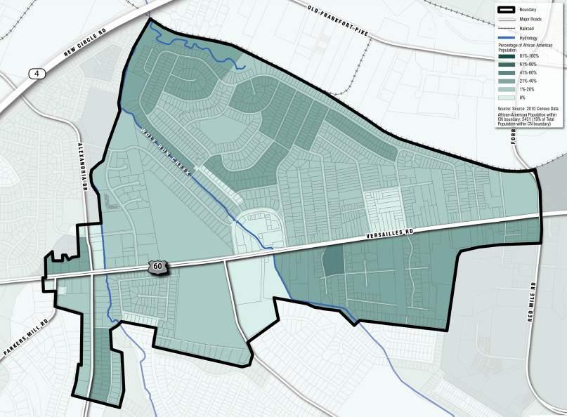

2.1.23 Population by Race - African American, 2010
Within the study area, the African American population is concentrated mainly on the northern and eastern part of the map. The northern edge by Valley Park, the southern portion around Cardinal Valley Elementary School, and the southeast area of Versailles Road have the highest percentage of African American population.
2.1.24 Population by Ethnicity - Hispanic, 2010
As the map on the right demonstrates, the majority of the population that identify themselves as Hispanic resides on the western part of the study area and around Oxford Circle, where multi-family homes are available.

2.1.25 Demographic Highlights
For the Cardinal Valley Study Area...
For all of Lexington-Fayette County...
HISPANIC (APPROX. 30%)
AFRICANAMERICAN (APPROX. 20%)
... out of approximately 12,605 residents
HISPANIC (APPROX. 7%)
AFRICAN-AMERICAN (APPROX. 14%)
... out of approximately 295,803 residents.
2.2 Major Issues & Opportunities
1) The neighborhood contains diverse housing options, but there is a need to ensure affordability;
2) Another key issue for housing is to encourage a healthy mix of ownership and rental housing;
3) The area contains aging structures and infrastructure in need of reinvestment;
4) The community is a melting pot of diverse ages and cultures, which is both a strength and a challenge for communication and advocacy;
5) Existing community facilities and parks are anchors for the area, but there is an opportunity to expand and improve centralized social and community services;
6) The area overall has a challenging economic environment with low incomes, but with growing entrepreneurial activity that can be celebrated and supported;
7) Versailles Road serves as the key corridor for both the neighborhood and the larger City of Lexington, but it needs comprehensive improvements for mobility and image;
8) The area contains significant natural features that can provide an unparalleled open space network;
9) The neighborhood’s major corridors need significant investment in alternative transportation to serve a transit-dependent population, including pedestrian, bicycle and transit improvements.
3.0


