5 minute read
-
ID# Project Description
Objective: Build a foundation for the potential connection between the commercial district of Alexandria Drive and the shopping centers in Gardenside
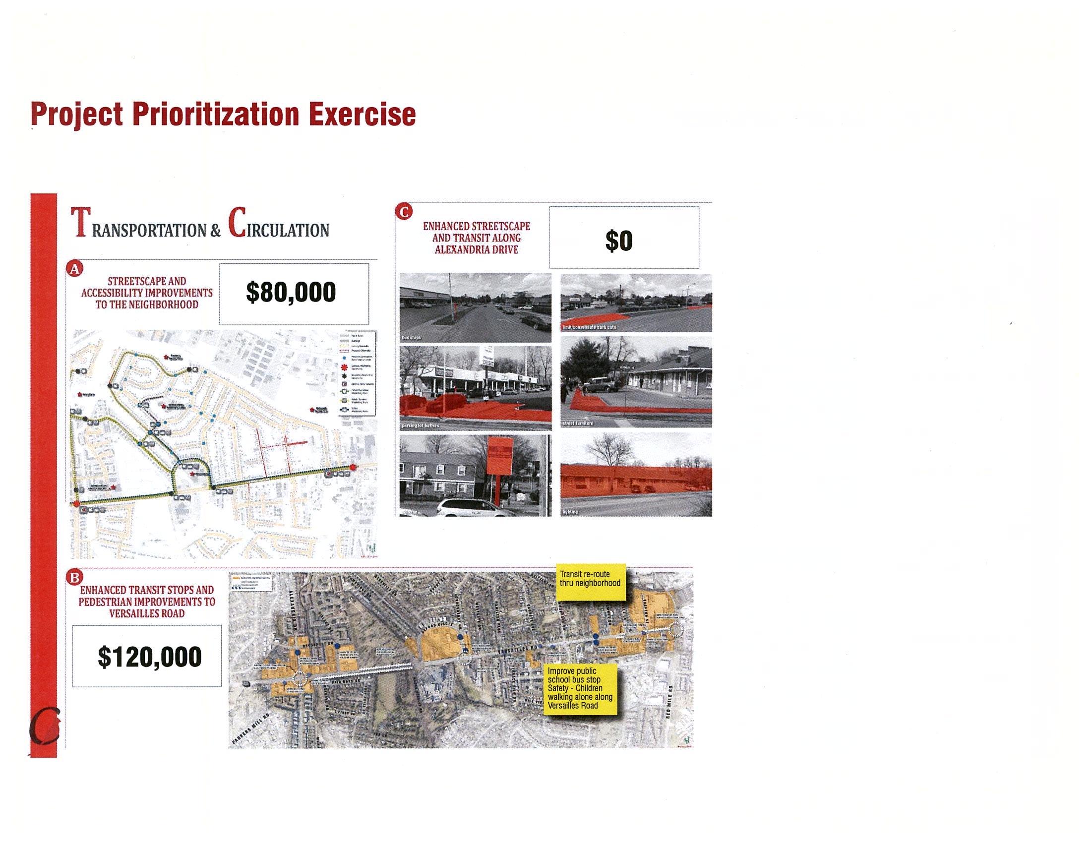
AD_5 Streetscape Improvements
Improve the streetscape character between the Gardenside commercial area to north of Alexandria Drive City signage. AD-7 Add /enhance transit stops Improve bus shelters along
Costs exclude design, right-of-way, and utilities and are in 2015 constant dollars.
AD-8 are approximate
General upgrades including parking lot buffers, street furniture, outdoor seating space, etc.
Enhancements can be as little or as much as the merchants have an appetite for.
LF = linear foot LS = lump sum SF = square foot
Oxford Circle Neighborhood Center Actions
Goal: Redevelop Oxford Circle as a community space by providing public services such as a new library and community center, as well as neighborhood-serving retail
ID# Goals Actions Types of Assistance Potential Implementation Partners Funding Sources
Objective: Encourage partnership between the city and private investors as potential funding sources and advocates
OC-1 Public/private funding
Find opportunities for the City to partner with one or more private investors to leverage funding for a new center.
LFUCG, Lexington Public Library, YMCA, Community Action Council
LFUCG, Private Source(s), Grants, Brownfield Programs
Objective: Encourage the implementation of a feasibility study for the area with the full involvement of the existing business community and potential partners
OC-2 Implement a feasibility study for the Oxford Circle Neighborhood Center
Following the identification of potential partners a feasibility study would include a programming report, schematic design of the center, traffic, parking, and environmental studies, cost analysis and funding, and outline assistance for existing property owners.
LFUCG
Objective: Work with existing land owners to identify opportunities for relocation or compensation
OC-3 Relocate or compensate existing land owners
Meet with individual land owners and determine their interest in relocation or compensation for their property.
Property/business owners can choose to stay where they are, be relocated elsewhere in the community, or be given fair market compensation.
Oxford Circle Neighborhood Center Projects
LFUCG
LFUCG, Private Source(s)
LFUCG - CDBG Funds, Private Sources
Goal: Build upon the diverse character and businesses in the Alexandria Drive area to promote an International District. ID# Project Description
-
Objective: Enhance pedestrian and transit facilities around Oxford Circle
Streetscape Improvements Improve the streetscape character around Oxford Circle
OC-5 Add /enhance transit stops Include new transit shelters along Oxford Circle. An Art in Motion stop would be ideal.
Costs exclude design, right-of-way, and utilities and are in 2015 constant dollars.
Costs exclude design, right-of-way, and utilities and are in 2015 constant dollars. Additional costs may be associated with an Art In Motion stop.
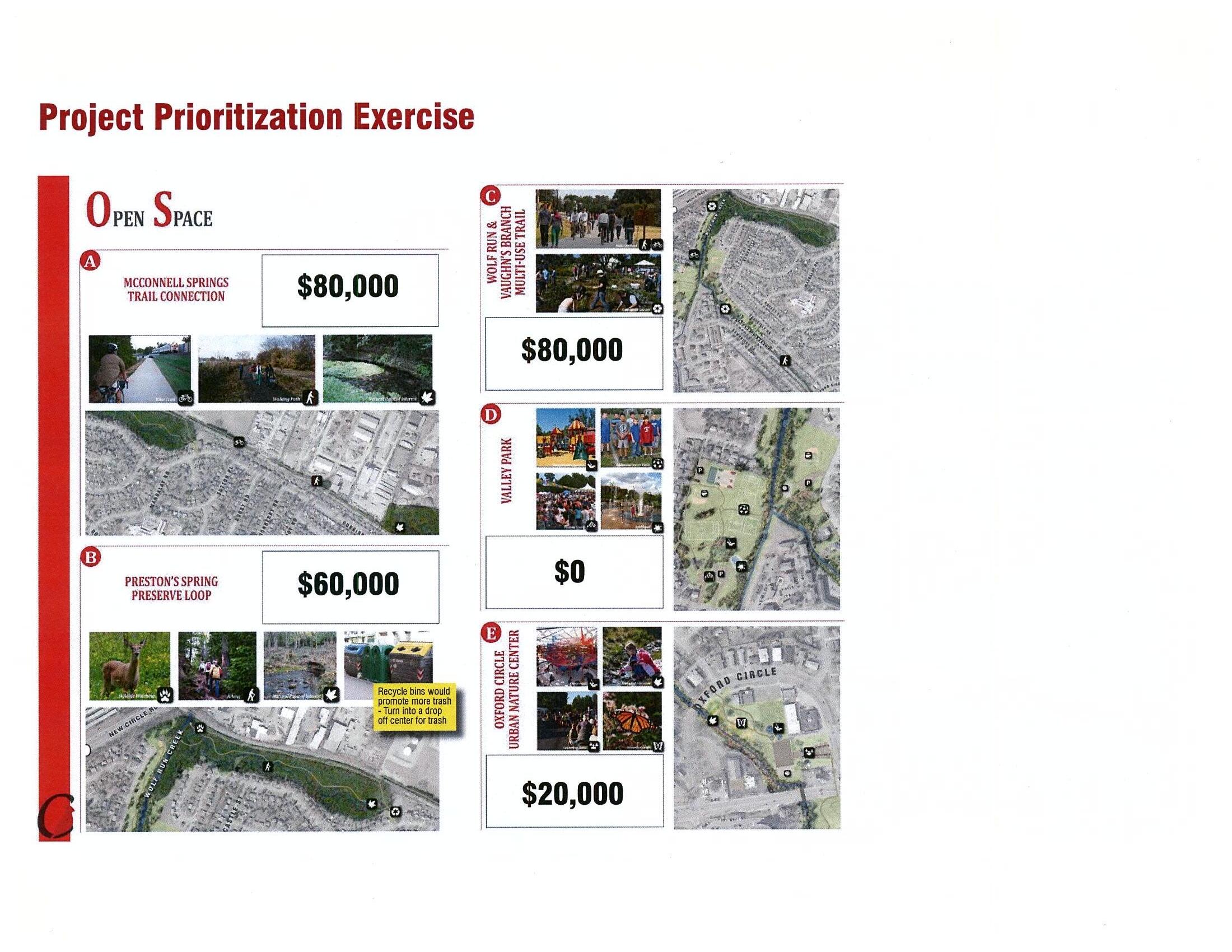
Open Space Network Projects
Goal: Improve the connectivity between the existing open space networks including new/improved public amenities.
ID# Project Description
Objective: Provide a multi-use trail connection along the existing Versailles Line to link McConnell Springs to Preston’s Spring
Trail
City, Friends of McConnell Springs, RJ Corman, Friends of Wolf Run
Objective: Formalize a natural preserve trail loop through Preston’s Spring
OS-2 Entry signage and improvements the nature trail running through the southern portion of the park
OS-4 key natural features of the dumping
+/-8 foot wide asphalt path. Access/use of active rail line will require extensive permitting and coordination with the railroad.
City,
Friends of Wolf Run, Cardinal Valley Neighborhood Association
Friends
LF = linear foot LS = lump sum SF = square foot
Open Space Network Projects
Goal: Improve the connectivity between the existing open space networks including new/improved public amenities. ID# Project Description
Objective: Create a multi-use trail along Wolf Run and Vaughn’s Branch to connect Preston’s Spring, through Valley Park and the neighborhood, to the Oxford Circle Urban Nature Center and Versailles Road
OS-7 Off-Street Multi-Use Recreation Trail
Trail connection from northern end of Wolf Run to Versailles Road
Friends of Wolf
OS-8 Accessible bridges over Wolf Run and Vaughn’s Branch
ADA compliant bridge crossings: over Wolf Run just south of the New Circle underpass; from Kilrush Drive to Deauville Drive; and, from Deauville Drive to alley behind Cambridge Drive apartments garden within
Bridge construction over sensitive waterways will be an involved process. Until these bridges can be installed alternate routes can be used along sidewalks and by way of the existing Valley Park Bridge. Costs would need to be determined through engineering studies. Environmental studies will also most likely be a factor.
Install
Objective: Improve the Valley Park Recreation Center, Sports Fields, and Playground
OS-10 Enlarge or build a new Valley Park Recreation Center
City,
Valley Park Board
OS-11 Upgrade playground Upgrade existing playground equipment as well as add new, accessible playground pieces
Open Space Network Projects
Goal: Improve the connectivity between the existing open space networks including new/improved public amenities. ID# Project Description
OS-12 Improve/maintain existing sports fields
Set aside additional funding to maintain existing sports fields that are under heavy use or reimagine the park layout and improve/add to the fields
OS-13 Install a splashpad
Incorporate an accessible splash pad for use during summer months
Objective: Preserve portions of the area around Oxford Circle for an Urban Nature Center
OS-14 Create and maintain a butterfly garden and waystation
Install a butterfly garden and waystation within the floodplain portion of Vaughn’s Branch along the edge of the Oxford Circle Commercial Center. This will be an ongoing project that will take 3 - 5 years of ongoing maintenance involving bush honeysuckle eradication, weeding, pruning etc.
Informational Signage signage describing the key natural elements found in and around the creek
A feasibility study would need to be completed with Division of Parks and Recreation to determine how funding could be allocated.
An entity, such as a neighborhood group, may need to be created to help establish, run, and maintain the community garden. These are approximate costs for plants, minor contracting, and a small waystation. Further estimates would need to be made.
These are approximate costs of signage. Coordination with the City is suggested for consistency.
Objective: Promote the development of the potential 3+ miles of dedicated mixed-use trail loop throughout Cardinal Valley
+/-8 foot wide asphalt path. Access/use of active rail line will require extensive permitting and coordination with the railroad.
Costs exclude design, right-of-way, and utilities and are in 2015 constant dollars
Costs exclude design, right-of-way, and utilities and are in 2015 constant dollars *This portion of the trail overlaps with the recommendations of the Versailles Road Corridor Improvements Study.
Objective: Make connections to the greater open space network
Open Space Network Projects
Goal: Improve the connectivity between the existing open space networks including new/improved public amenities.
OS-19 On-Street Multi-Use Recreation Trail
Streetscape improvements along Versailles Road from Oxford Circle to Hillcrest Memorial Cemetery City
OS-20 Off-Street Multi-Use Recreation Trail Trail connection from Oxford Circle to Pine Meadows Park City, Friends
Objective: Stream restoration of Wolf Run and Vaughn’s Branch
OS-21 Continue efforts to restore Wolf Run and Vaugn’s Branch
Reduce stream bank erosion, improve aquatic habitat, improve water quality by capturing trash and debris, providing for a native riparian buffer zone along more of the stream channel, and provide water quality treatment to enhance pollutant reductions
Costs exclude design, right-of-way, and utilities and are in 2015 constant dollars *This portion of the trail overlaps with the recommendations of the Versailles Road Corridor Improvements Study.
+/-8 foot wide asphalt path. Access/use of active rail line will require extensive permitting and coordination with the railroad.
An engineering study would need to be completed to understand the full extent of a restoration needed.
