PORTFOLIO | YAN ZEMIN

B.Arch Huazhong University of Science and Technology
APPLY FOR UCL MArch Architectural Design
Application number: 23160573
liam_yen@163.com
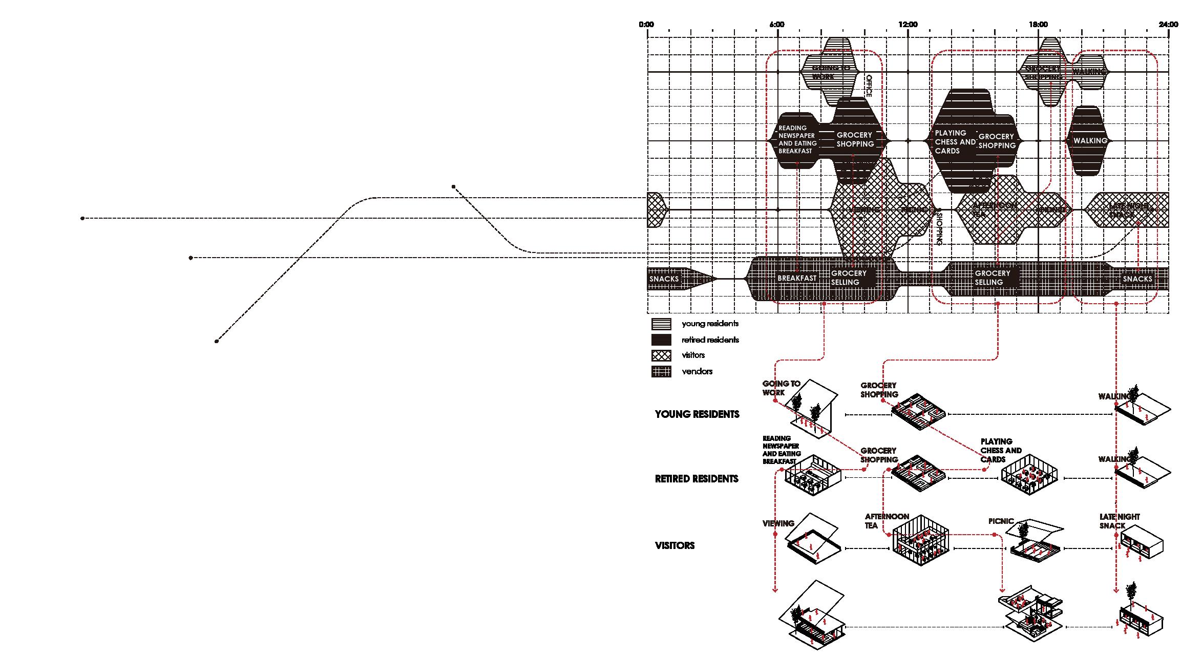
About Complexity
Architecture, as the smallest unit that constitutes the human habitat, is the most closely related to human behavior patterns, and is the direct medium through which humans come into contact with the huge complex of the city, and is the link between people and the city. I also believe that architecture can play a more direct role in solving some social problems.
In today's world of explosive economic and technological development, unprecedented urbanization rates and information dissemination, the surrounding environment that individual people come into contact with is extremely complex and varied. Therefore, diverse cultures, changing climates, large numbers of people, complex social needs, and cities with huge scales that are difficult to reach boundaries make architecture even more significant as a medium between people and complexity. believe that, as with the Guggenheim Museum Bilbao, a single building can make a huge difference to the solution of complex urban problems. In this context, architecture is confronted with an unprecedentedly complex environment.
With the increasing complexity of social and urban structures, it is necessary to rationally analyze urban problems and opportunities in the complex environment, and put forward proper spatial solutions. Chinese cities are facing this trend of increasing cultural, demographic and urban complexity, while most of the former buildings have been formatted to meet a single function, blindly demolishing and building for economic growth without addressing the urban issues of today and tomorrow. I believe that in-depth analysis of the urban environment and sorting out the intricate economic and cultural relationships are crucial to the design of China's urban architecture today and even in the future, and this is what is missing in the Chinese architectural design industry nowadays. In this portfolio will present my thinking on complex urban problems in different geographical areas and propose architectural solutions based on urban research.
Based on my reflection on mordern city and its complex condition, choose to apply for your programme of MSc Architecture, aiming to widely become familiar with more advanced architectural theories and technologies in order to deepen my understanding of architecture. More importantly, it is vital to further improve my logical thinking ability, critical skills and the sensitive to urban problems, as well as think and react more deeply. The subsequent graduate studies can equip me with the strong capacity to properly deal with complex social problems in future workplace and even explore the boundaries of problem solving by architectural language.
01 | BRIDGE
Urban Renewal to Recall Jiangnan Culture
HUST Architecture Studio

2021 Winter
Site: Hangzhou, China
Instructor: Chen Hong
Individual Work/ Academic Work
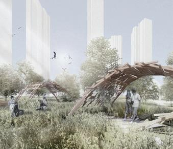
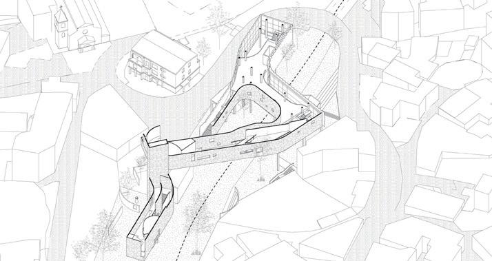
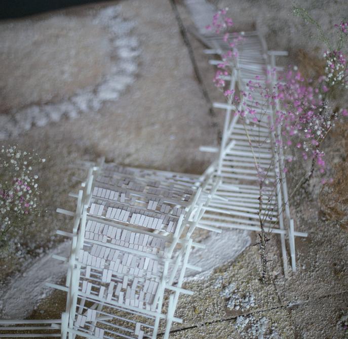
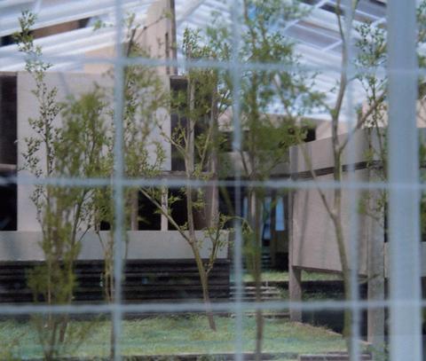
West Lake as the most famous tourist attraction in the historical city of Hangzhou not only has a stunningly beautiful natural scenery, but also no shortage of humanistic landscapes that tell the history and traditional Chinese culture, which attracts countless tourists to come and see, in the process of Hangzhou's rapid development, car lanes, high consumption places, huge size of the neighborhood, so that the beautiful scenery of the ancient city of Jiangnan with small bridges and flowing water has long disappeared. A neighborhood located on the east side of West Lake, near numerous cultural and historical monuments and the most prosperous commercial area by West Lake, is a significant place to restore the historical mark of Hangzhou.
In the ancient city of Jiangnan, which has a well-developed water system, water and bridges are important elements of urban transportation, with "water" being the transportation of goods within the city and bridges mending the fragmentation of the neighborhood caused by waterways. The two together create a unique spatial atmosphere in Jiangnan, China. In the venue, the spatial element of "bridge" is regained to mend the fragmented neighborhoods and to create permeable streets for people to explore, so that people can integrate into them and recover the urban memory and traditional Chinese culture of Hangzhou that has been lost in the consumer society.
CONNECTION OF HISTORY AND MORDERN


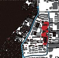
The site was chosen in an area on the eastern shore of Hangzhou's West Lake, an area dominated by residential buildings and currently of relatively low economic value.
Relatively speaking, the old city center of Hangzhou is the gathering area of many shopping malls, and there are more historical buildings, which have high commercial value and tourism value, while the new city center is the gathering place of many company headquarters, with many high-rise buildings, and is the cbd of Hangzhou, which has high commercial value but not high tourism value.
The selected site has a high density of residential buildings and a high population density, but it is close to the West Lake tourist area and has many historical points of interest, so it can be developed as a key cultural tourism area in Hangzhou in the future and has a large potential. The three areas are connected to Hangzhou East Railway Station by three subway lines, making transportation more convenient.
MAPPING OF HANGZHOU


The buildings form an unbreakable boundary with the residential area, while the great scale of the urban block causes limited accessibility to the scenic area on the eastern side of the site, while the through-going carriageway leads to a poor walking experience. There are many public spaces within the site, but the public spaces are not open to the public, creating narrow and crowded walking paths within the site with no areas to stay. There are two historical and cultural attractions within the site, Confucius Temple and qianwang temple, but the West Lake scenic area in the east is full of high consumption places, attracting tourists to spend money, while the historical and cultural attractions are buried among the consumption places and unattended.

Modern city lanes, residential boundaries, high-spending venues, uniform modernist residential buildings and long block form a barrier between residents, tourists and the historical sites, scenic areas of West Lake, and people gradually lose their identification with traditional culture.

Urban design needs to break down these barriers in order to create a circulation of tourism through the attractions and West Lake scenery and a circulation of residents for community functions within the neighborhood

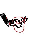
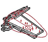
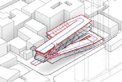
HISTORICAL RIVERS AND BRIDGES
river bridge
Contrasting to the 1905 map of Hangzhou, many of the original rivers and bridges have been removed from the current site and replaced with vehicular roads, which became the river of modern society, but the bridge was eliminated by the times so relatively speaking, many of the culture and characteristics of Hangzhou as the ancient city of Jiangnan in China are gradually disappearing. hope to recreate the original city mark of Hangzhou in the design.
GENERATION PROGRESS
RIVER AND
BRIDGE
PUBLIC SPACES
VISTORS' CIRCULATION


RESIDENTS' CIRCULATION

LANDSCAPE CIRCULATION
Extracting elements of the old Hangzhou rivers and bridges, restoring the city's marks and characteristics, while using the bridges as nodes to connect the closed block to the West Lake scenic area in the west, breaking the barrier of the neighborhoods.


Utilizing the existing public space of the site, giving multiple functions and revitalizing the original closed and cramped urban space.

Extracting the spatial rhythm and order changes in the map of a thousand miles of rivers and mountains to control the spatial changes of the tour site, forming a tour flow line from land to waterway and then to land.


The side of the site away from the West Lake scenic area is a place for residents' living facilities in the block, giving them a place to enrich their daily activities and restoring their sense of identity with the traditional culture of Hangzhou.
Form a landscape flow line along the shore of the West Lake, using some resilient city techniques to prevent urban flooding while allowing residents and tourists to visit and experience the scenery and culture of the West Lake.
Referring to the spatial pattern of the ancient Jiangnan water city, the spatial prototype was extracted and applied in the design. The spatial functions, spatial sequences, and formal prototypes of the ancient city of Jiangnan are used to realize the convenience of residents, evoke urban memory, and cultural identity respectively.


The system also includes cultural facilities to revitalize the space and educate residents about traditional culture.
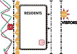
RESIDENTS
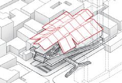
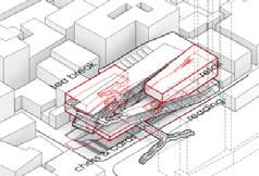
OVERVIEW OF INTERVENTION


public space retail
greenery space cultural facility quay temple turning point

VISITORS
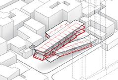
NODE 1 is the southernmost "bridge" of the site and its subsidiary functions, the bridge is related to the surrounding qianwang temple, the West Lake scenic area and the residential area across the carriageway, and is endowed with many subsidiary functions, including the related museums, exhibition halls and tea culture parks around the qianwang temple.


SPACE PATTERN
Based on the space prototype of the "bridge", it is expanded to include many functions that are in line with modern urban life.


a good

SPACE PATTERN
Based on the spatial prototype of "public space", the open-air Yue Opera Theater is the center of the park, recreation, observation tower and other functions and complex circulations.Provide a place for visitors and residents to interact with each other.


SPACE SEQUENCE

FUNCTION
The first part is the theater area, which contains the theater, the surrounding ancillary flow and the refreshment function. The second part is the park area, which contains cultural stores and provides residents and tourists with the function of playing and resting. The third part is the exchange area, which contains the exhibition hall related to Yueju opera and the observation tower of West Lake.

Scene from the open-air Yue Opera Theater:
Centered on the theater, the perimeter is endowed with multi-layered corridors to attract residents and visitors passing by.

Scene with complex circulation:
Three steps intertwine to form a complex flow, providing an uncertain interest similar to that of the ancient town of Jiangnan.
node 2 is a park with the theme of Yueju, the traditional drama of Hangzhou, which is gradually replaced by mainstream media in modern society. This park tries to revive people's love for Yueju by including a number of Yueju museums and cultural halls, as well as an open-air Yueju theater, giving many residents and visitors functions where residents and visitors have a common point of interest and where residents and visitors interact with each other, forming an important node for promoting the traditional culture of Hangzhou.

The observation tower is composed of multiple curved roofs, forming an architectural resemblance with the characteristics of ancient China's Jiangnan, different roofs form different spatial feelings, and the landscape of the West Lake in the distance can be felt under the continuous change of architectural space.


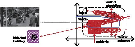
A venue for residents to gather at the main entrance of the Confucius Temple, where public functions such as lectures, deliberations and propaganda can be carried out, giving the government, educational institutions, media organizations and residents a place to communicate and express their ideas.

NODE 4 QUAY


node4 is the southernmost quay in the design, based on the ancient town extracted from the quay space prototype, give tea breaks, arts and crafts retail and other relatively commercial functions. The observation deck of West Lake is combined with the interior building to form an external circulation alone on the waterfront side, and conntected to the function of the quay, so that viewing activity is combined with the consumption activity inside the building. At the same time, more natural techniques are used here, so that visitors can feel the experience of intermingling nature and culture.
LANDSCAPE DETAIL
hard wood floor grass planting
thermal insulation layer moistureproof layer tree roots

concrete profiled deck stone subbase

The ecological approach of a resilient city is used in the water-friendly landscape to provide visitors with a better green landscape while also using landscape facilities to a certain extent to alleviate the problem of urban flooding during the rainy season.At different water levels, visitors can experience a different view of West Lake
planting soil soil subgrade outfall pipe stone subbase soil subgrade
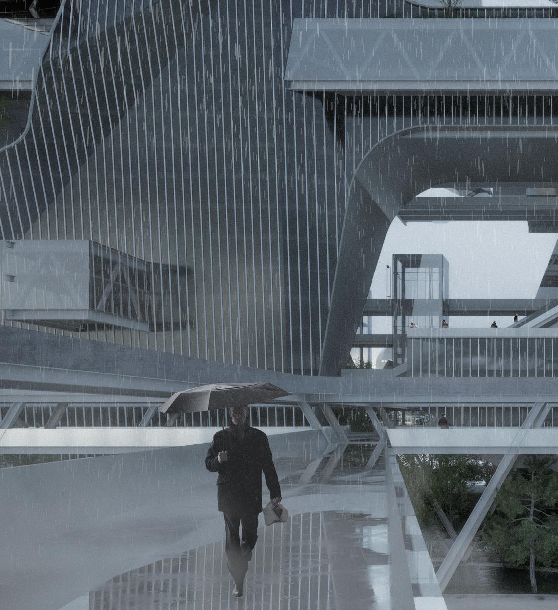
Scene of the architecture from the water: The side of the building facing the water forms the traditional Chinese façade of a continuous undulating roof02 | NATURAL STATION
Green House Restaurant to Evoke Agricultural Life

HUST Architecture Studio
2021 Summer
Site: Mývatn, Iceland
Instructor: Lei Jingjing
Individual Work/ Academic Work
The relationship between human beings and nature has become disordered to a certain extent, and we need to go beyond the perspective of industry and technology to re-cognize the relationship between human beings and nature, and agriculture is the most direct manifestation of the relationship between human beings and nature in the process of social development, and it is worth to be discussed again. As one of the coldest civilized countries in the world, Iceland has preserved its natural landscape to the greatest extent, and most of the land is still in an unexplored state.
In this project, people have the opportunitiy to move from fast to slow, from urban to rural, when they taste the pure and natural food , watch the farming and picking that gradually leave the memory of people in the city, and even participate in the agricultural production.
The site was chosen in Mývatn located in the north of Iceland and is surrounded by numerous tourist attractions
FUNCTION
MASTER PLAN
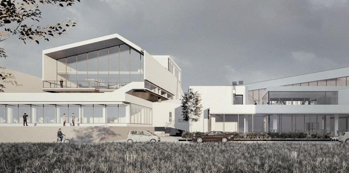
The chosen site is located at the intersection of agricultural areas and natural landscapes, with forests and the Hverfjall volcano to the south, as well as two farms to the north. The site is adjacent to a Mývatn thermal bathing area. Therefore it is an excellent starting point for tourist routes and an area to experience Nordic agriculture for visitors. The building is therefore expected to be a node of the tourist route, providing a resting place for tourists and a place where people tired of city life can experience the joy of agricultural life.
COLLAGE OF AGRICULTURE AND ATTRACTIONS
The functions of the building are divided into two parts: visitors and logistics. All visitors' functions want to interact with the planting area or be able to see the green plants, while the planting functions in logistics are directly linked to visitors' picking and playing through the planting area, forming a complete dining circulation from planting to picking to preparation to cooking and finally to dining.


STRATEGY
Visitors can visit the entire flow of food and beverage production from the time they enter the restaurant to the time they eat, while participating as part of the process themselves. In addition to the dining experience, the building is derived from the natural attractions to the south, creating multiple modes of interaction with nature.
GENERATION PROGRESS
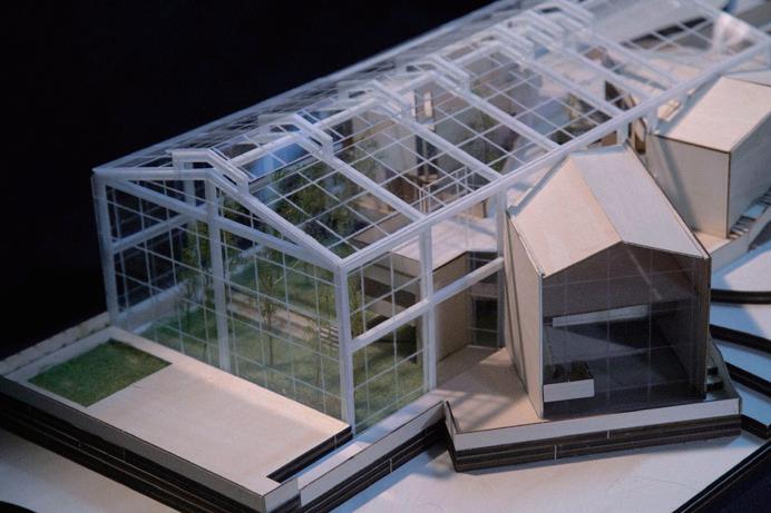
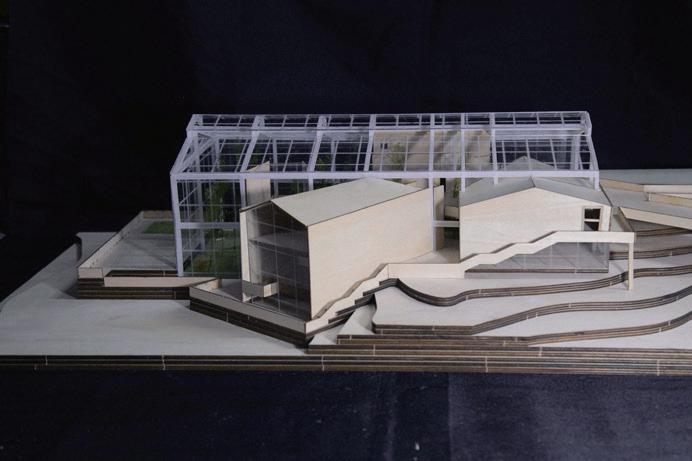
the greenhouse is placed in the site,and a multi-layer continuous planting form is set up on south part of the green house.The greenhouse is a glass box facing the volcano to the south, with a view of the volcano from most of the restaurant.


The external dining space is twisted at an angle to face the light blue hot spring pool directly to create a good view of the dining area, while the external flow line is set up at the periphery of the building to provide a flow line for visitors to take photos and view the scenery.
FUNCTION

The southern part of the greenhouse is the planting area and the northern part is the functional area, both of which are intertwined so that visitors can experience any function in the restaurant while in contact with the plants in the planting area.The two dining spaces are divided into opposite interior planting areas and opposite exterior landscaping.
ENERGY SAVING
Rainwater harvesting devices are installed at the end of the sloping roof for irrigation, electric curtains are installed at the top of the functional areas to reduce the direct UV radiation of the greenhouse, and side windows are opened at the top of the building to provide smooth ventilation inside the building.
BLOCKS

The building is divided into two dining blocks, a kitchen block, and a multifunctional block, which is placed in the greenhouse and interacts with the planting area and the natural landscape. The materials used are mainly eco-friendly and natural wood.
1. The inward-facing dining block has two levels and is placed above the planting area, surrounded by vegetation, so that visitors are in a green environment during the dining process.

2. Outward-facing dining block facing the Mývatn Nature Hot Springs to the south, offering three levels of dining space.


3. The kitchen block is connected to the planting area,forming a circulation from planting to serving


4. The multi-purpose block also faces the planting area and creates a separate flow on the other side with views to the west side of the building

SCENE
With the sinking of the terrain, the planting area forms a continuous sinking form, visitors with the flow of food and beverage, the entire planting area wil slowly emerge, visitors in different areas of the building and planting area interaction occurs.


 Scene of open planting area


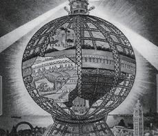
 Scene of commercial bubbles from platform: The shaped space creates a rich walking experience,and recreating the early 20th century imagery of Coney Island's amusement park
Scenario of Global Tower,1906
Scene of commercial bubbles from platform: The shaped space creates a rich walking experience,and recreating the early 20th century imagery of Coney Island's amusement park
Scenario of Global Tower,1906


 Set up a work shop above the green area in the middle of the building and an open-air screening room and other more public functions connected to the school and library
SECTION A-A
The stage of theater is set above the green area in the middle and connected to the concert hall on the other side, while the open-air performance space is set on the roof.
Set up a work shop above the green area in the middle of the building and an open-air screening room and other more public functions connected to the school and library
SECTION A-A
The stage of theater is set above the green area in the middle and connected to the concert hall on the other side, while the open-air performance space is set on the roof.


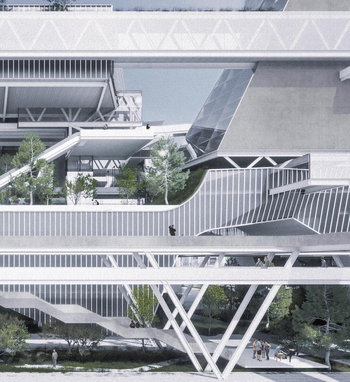


 Scene in the chess & cards activity area.
A variety of people (including grocery shoppers, chess players, visitors, and residents taking tea breaks) form a visual and physical exchange in the area to meet the needs of residents gathered around.
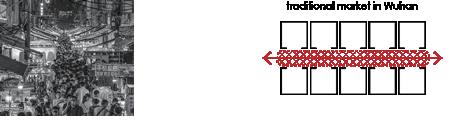
Scene in the ramp market. Formation of a space atmosphere similar to the traditional market in Wuhan.
Scene on the greenery ramp
The top of the ramp forms a good walking space with the technique of green roof, and the structure of the roof forms a decorative effect.
Scene in the chess & cards activity area.
A variety of people (including grocery shoppers, chess players, visitors, and residents taking tea breaks) form a visual and physical exchange in the area to meet the needs of residents gathered around.
Scene in the ramp market. Formation of a space atmosphere similar to the traditional market in Wuhan.
Scene on the greenery ramp
The top of the ramp forms a good walking space with the technique of green roof, and the structure of the roof forms a decorative effect.