
5 minute read
National Park & Bushwalks


(above) Leura Cascades by Claire Weaver (below) Overlooking the Wollemi Pines (below right) Hanging Rock, Blackheath by Denys Joannes One of the most appealing aspects of the Blue Mountains region is the accessibility it offers visitors of all ages. There are so many ways to make direct contact with the area’s history, culture and spectacular natural beauty.
Along with numerous walking tracks, there are plenty of ideal spots for rock climbing, hang-gliding, canyoning, caving and horseriding. Take any trail and you can expect to experience great diversity in terms of scenery, watering holes, plants, trees, birds and wildlife, along with many cultural and heritage sites. You’ll also see fine examples of early stonemasonry and the practical use of natural materials, which have ensured that constructed features blend into the landscape.
Tracks cater to all abilities - the Fairfax Track in Blackheath, for instance, is a short walk that allows you bring a stroller so family members of all ages can enjoy the glorious views across Govetts Leap.
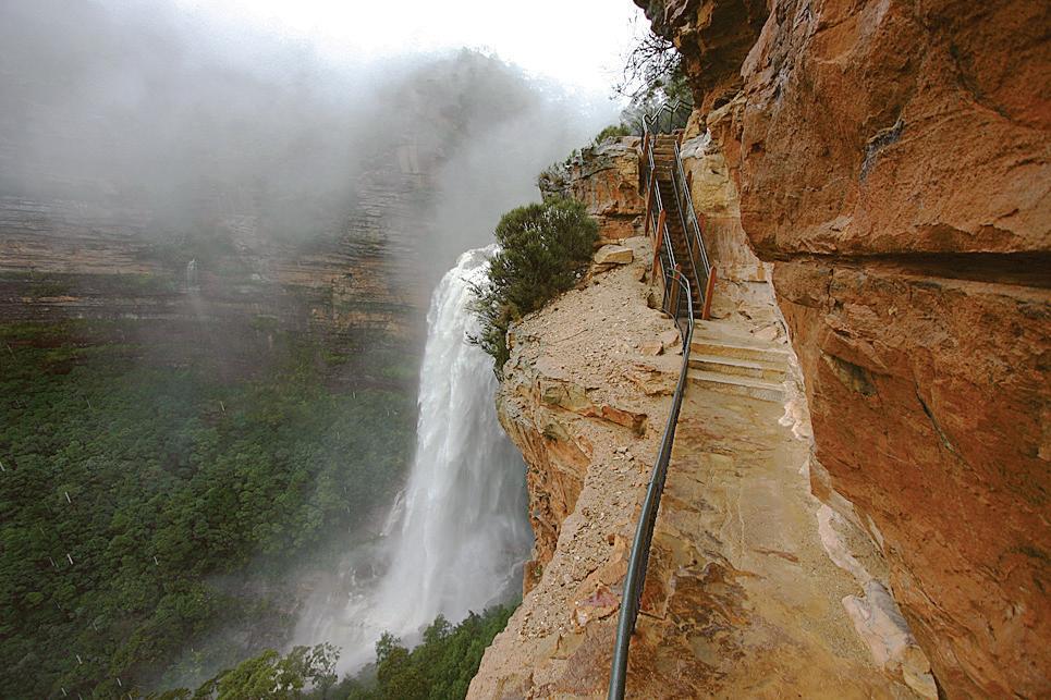
The Blue Mountains is famed for its natural beauty and bushwalking. The BM Heritage Centre at the end of the built area on Govetts Leap Road Blackheath, just before the spectacular lookout is a good place to check out before setting out on your walk. The knowledgable staff can answer all your walking and locational questions and there is also a well stocked souvenir and outdoor shop and a gallery featuring a new exhibition each month. The historic National Pass Trail in Wentworth Falls, is considered one of the country’s finest walks. It’s a six-kilometre round trip featuring majestic wild scenery, waterfalls and a Grand Stairway with 173 hand-carved stone steps. The Pass is generally agreed to be a three-hour walk for anyone that has a reasonable aerobic
fitness level.


For a challenging walk, try Narrow Neck Trail, in Katoomba. Tracing the elevated platform of Narrow Neck Peninsula, this walk takes you through open forest, heath and swamplands, and offers spectacular views over Lake Burragorang. The trail also leads from Golden Stairs to Ruined Castle – an outcrop of large boulders. This is one of the best day walks in the Blue Mountains.
Walking trails are well documented in countless guidebooks and you can find plenty of information online. We recommend Blue Mountains Best Bushwalks by local author Veechi Stuart. A passionate bushwalker and nature lover, Veechi lists over 65 walks, from historic and well-travelled to quieter tracks known only to a few.
Once you’ve decided on a track that suits your fitness level and what you want to see, it’s a case of packing plenty of water and sensible clothing, and letting family and friends know where you’re headed. Be sure to stick to your chosen trail - the region is magical and filled with wonder but it is a wilderness area that needs to be treated with the utmost respect.
Formed over 50 million years ago, the Greater Blue Mountains World Heritage Area is acknowledged by UNESCO for its remarkable geographic, botanic and cultural value, including protecting sites of Aboriginal cultural significance. It’s also ECO certified by Ecotourism Australia - your guarantee that all experiences within the park are supported by well-managed sustainable practices.
The region comprises eight protected areas, most of which form part of the Great Dividing Range: • Blue Mountains National Park: Covering around 268,000 hectares, this park is the most central of the protected areas and is accessed via all villages in the Blue Mountain. Four major rivers have most of their catchment inside the park – the Wollangambe River in the north, the Grose River in the centre and the Coxs and Wollondilly rivers in the south.
• Wollemi National Park: The second-largest national park in the state, this park covers 361,113 hectares and is key to maintaining the quality of many tributary rivers to the Hawkesbury and Goulburn-Hunter river catchments. It is home to many Aboriginal sites with cave paintings, axe-grinding grooves and rock carvings. • Yengo National Park: This is the most north-easterly of the eight protected areas and is located in the Lower Hunter region. The course of the Macdonald River flows from the northwest of the park to the southeast, where it joins the Hawkesbury River.
• Nattai National Park: Encompassing the valley of the Nattai River, this 48,984-hectare park is surrounded by spectacular sandstone cliffs and covered in dry forest. If you want a real walking challenge, take the Katoomba to Mittagong Trail – 132 kilometres in length, it will take you directly through the heart of the World Heritage Area.
‘... Along with numerous walking tracks, there are plenty of ideal spots for rock climbing, hang-gliding, canyoning, caving and horseriding. Take any trail and you can ex pect to experience great diversity in terms of scenery, watering holes, plants, trees, birds and wildlife, along with many cultural and heritage sites ...’
• Kanangra-Boyd National Park: Located in the Central Tablelands region, this park covers 68,660 hectares and features three notable waterfalls systems – Kalang, Kanan gara and Morong. Three great walking tracks are the easy and wheelchair-accessible Lookout Walk; Waterfall Walk, which leads to Kalang Falls; and Plateau Walk, which goes all the way to Katoomba.

• Gardens of Stone National Park: Taking its name from the natural stone pagodas that sit within its boundary, this park covers 15,080 hectares and boasts a number of limestone outcrops, karts and elevated swamps. • Thirlmere Lakes National Park: Set in the Macar thur area of New South Wales, this 629-hectare park comprises lakes thought to have formed around 15 million years ago. The habitat surround ing the lakes is open forest with rough-barked apple, Sydney peppermint and red bloodwood trees.
• Jenolan Karst Conservation Reserve: The most westerly of the eight protected areas, this is home to the Jenolan Caves. The Jenolan area has been part of the culture of local indigenous peoples for thousands of years, and holds special significance


