
8 minute read
Town maps


Bushwalk - Furber Steps, Federal Pass, Ruined Castle - Katoomba
and coal out of the valley, but by 1932 was already a tourist attraction. Just past the Scenic Railway the track forks; stick to the right, following signs to the Landslide. This walk descends Furber Steps and joins up with the Federal Pass, opened on January 1st About ten minutes further on, 60 metres past where steel cables cut across the track, you’ll see a faint 1901 in honour of the federation of Australian states. A long but relatively easy-going day, pad veering off to the left — this is the Williams’ Landslide Deviation, a more direct but rather indistinct most of this walk passes along the sheltered forest floor before popping out at the Ruined route to the Golden Staircase. Ignore this track; keep going straight ahead. Castle, where 360° views offer a sense of being ‘on top of the world’. Grade: Hard. Time: 7 hours. Oak St Scenic World 2 1 An exposed coal seam marks the first of the landslides, opening up to the massive landslide -caused by mining activities - which fell on three separate dates during 1931. Steel poles and the occasional white arrow mark the Distance: 14.4 kilometres return. Ascent/Descent: 370 metres ascent, 370 metres descent, plus 12 kilometres of undulating track. Weather: Suitable for all conditions. Closest public transport: Local buses 686 and 696 run between Echo Point and Scenic World, stopping P Golden Stairs Plateau 7 6 Glenraphael Dr C l i f f D r i v e 5 4 N 3 Furbers Steps route across bare rocks and water-scoured gullies. Beyond the landslide, the track widens, with drystone embankments evidence of the old horse-drawn tramway which led to the Ruined Castle mines. About 600 metres from the end of the landslide, just beyond a small creek crossing, look for the mine shaft recessed into the bank on your right-hand side. This is the Mt Rennie Tunnel, through which coal was transported from at the Katoomba Kiosk where the track begins. Finding the track Head down Katoomba Street almost to the bottom, turning right into Katoomba Falls Road. This road curves down to the bottom of the hill, where you’ll see Katoomba Falls Kiosk on your left. Narrow Neck Federal 9 8 C a u s e w a y C r e e k the Megalong Valley under Narrow Neck along a cable tramway. Another kilometre of level walking and you arrive at the track junction where the Golden Staircase descends from Narrow Neck (an alternative entry/exit point for this walk). Keep straight ahead. The vegetation changes as you continue through the forest: tall tree ferns give way to a long grove of coachwoods, later opening up to a tall forest Walk directions Pass of blue gums, angophora and black ash. Lyrebirds scratch underfoot and The track starts just a little to the right of the kiosk. old campsite bellbirds ring all around. There are several old miners’ campsites along this Descend concrete steps for 50 metres to the junction of three tracks. Head to your right, following signs for 0 300m stretch, as well as the ruins of an old hut. About 45 minutes (2.5 kilometres) from the Golden Stairs junction, turn right at the sign to the Ruined Castle. Katoomba Falls Track. Shortly after Witches Leap, you arrive at the Round Walk junction. Turn left, following signs to Furbers Castle Head 10 old campsite A steep, rocky ascent leads to the top before you head south-east along the spine of the ridge. The broken shapes of the crags at Ruined Castle make it easy to understand steps. These steps lead past Rainforest Lookout, the origin of its name, when an 1880 journalist described it as a ‘rocky pile the Queen Victoria Lookout and Furbers Lookout. (Ignore sidetracks to Underfalls Walk and Vera’s Grotto.) Look for 11 12 ruined keep of some gigantic castle’. The highest point is at the southernmost end, just before the track starts to descend. A short scramble delivers 360° ‘pick marks’ in the stone, evidence of where these steps Ruined Castle views: north to Castle Head; south to Warragamba; east to Kings Table; and were blasted from the cliff in 1908. Levelling out a little, the clay-floored track undercuts west to Narrow Neck, where the headwaters of Cedar Creek appear as twin sandstone overhangs before arriving at the Federal Pass. Turn right. waterfalls. The track descends back down to the Federal Pass. Turn left. After 600 metres you arrive at the original sign leading up to Ruined Castle. Return the way you came. (If you’re A few minutes further on, the inevitable crowd of tourists assembles at the foot of the Scenic Railway. planning to catch the Scenic Railway up the hill, remember the last one leaves at 4.45 pm.) These notes and description from Blue Mountains Best Bushwalks, the acclaomed
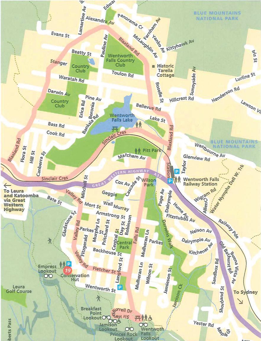
WENTWORTH FALLS
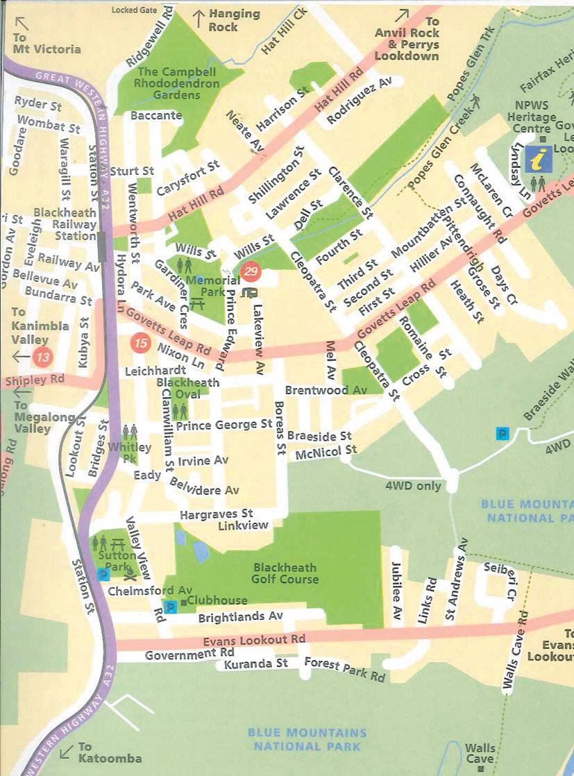
BLACKHEATH The Blue Mountains National Parks
Blue Mountains National Park, one of the most well known parks in Australia, is part of the Greater Blue Mountains World Heritage Area; listed for its remarkable geographic, botanic and cultural values, including protecting sites of Aboriginal cultural significance. This huge park boasts hundreds of kilometres of trails and walking tracks and there are great places to go camping, including Euroka or Blue Gum Forest where you can pitch your tent beneath the shade of a majestic eucalypt. Explore the park’s heritage tracks and lookouts, many of which were created for Victorian-era honeymooners and day-trippers. Imagine walking down some of the steep staircases and narrow tracks in a full suit or a dress with a bustle. Try the historic National Pass or take the cliff top bushwalk at Govetts Leap; a great walk for getting a sense of the land and spectacular views all the way down the Grose Valley. There are also great opportunities for adventure sports; challenging rock climbing spots, great canyons and horse riding. The views from the park’s lookouts are magnificent; you’ll look out over hazy blue forests, waterfalls and interesting rock formations. Echo Point at Katoomba is a popular spot, offering full views of the iconic Three Sisters, and at Sublime Point in Leura, you’ll be able to see 29km away on a clear day. Take a picnic lunch or thermos so you can stop for a while to admire the views. This park protects an unusually diverse range of vegetation communities. There are rare and ancient plants and isolated animal populations tucked away in its deep gorges. The Greater Blue Mountains Drive links a vast and spectacular World Heritage landscape and a number of national parks to the surrounding regions. Bushwalks There are a number of excellent bushwalking guide books widely available at stores across the mountains. Our favourite is Blue Mountains Best Bushwalks by Veechi Stuart. The National Parks Shop at Govetts Leap Rd Blackheath also has a wealth of bushwalking information, paraphenalia and souvenirs. Here is a short list by town of entry to some of the most rewarding bushwalks. Before entering the bush please consider some basic issues: 1. Weather in the mountains can change very quickly and losing one’s way occurs far too frequently, so also carry warm and wet weather clothing; 2. Take plenty of water for each walker. Local streams may be contaminated. 3. Take a good map and compass. 4. Always stay on the track where you can see what you’re walking on and to not damage the landscape or it’s flora and fauna. 5. This area is considered of world significance so please take out everything you bring in. 6. It is always advisable to register your walking intentions with National Parks or where you are staying so assistance can be given should you get into trouble. 7. Check the National Park website for further warnings, alerts or information.
A Selection of Bushwalks (from Blue Mountains Best Bushwalks by Veechi Stuart) The National Pass
Mount Victoria Looking out from Mount York Forest at Fairy Bower Bushrangers on the Zig Zag Track Solitude at Asgard Swamp Historic Mountain Passes Swimming at Victoria Falls Overnight in the Blue Gum Forest
Blackheath Lonely Lookouts at Pulpit Rock Family fun on the Fairfax Track Aboriginal heritage at Walls Cave Cliff top track to Govetts Leap Cliff top track to Evans Lookout Cliff top track (Pulpit Rock to Evans Lookout) The Grand Canyon circuit Mystery Tour of Porters Pass Birdlife at Popes Glen Cliff descent down Govetts Leap Discovering the Grose Valley
Katoomba A short walk for young children Katoomba by night Picnics and play at Minnehaha Falls Walking the cliffs from Scenic World Along the cliffs from the Three Sisters Prince Henry Cliff Walk Descending the Three Sisters Narrow canyon of Devils Hole Historic Federal Pass
Leura A sublime lookout Creeks and pools at Lyrebird Dell Rainforest, cascades and lookouts An easy walk to Moya Point The wild landscape of Fortress Rock Grand cliff top track to Wentworth Falls Wildflowers and wind at Lockley Pylon Cool rainforest at Fairy Bower Wentworth Falls View from Princes Rock Ancient perspectives from Kings Table Charles Darwin Trail Wentworth Falls and Rocket Point Secluded pools on the Nature Track Cliff top circuit Creeks and cliffs to the Conservation Hut
Picnics and train rides on the Federal Pass Ladders and forests of Wentworth Pass Hidden secrets of Roberts Pass Wentworth, Hippocrene and Vera Falls
Lawson to Springwood Picnics at Waterfall Circuit Dreamy beauty of Terrace Falls Martins Lookout to Lost World Bellbirds at Sassafras Gully Creek circuit on Wiggins Track Swimming holes on Glenbrook Creek Blue Gum Swamp
Warrimoo to Glenbrook Bird’s-eye view from Nepean Lookout Kangaroos at Euroka Rockhopping at Jellybean Pool Yabbies and picnics at Crayfish Pool Winter sun on Jack Evans Track Rock art at Red Hands Cave Camp Fire Creek to Red Hands Cave Secrets of Florabella Pass Offtrack adventure along Glenbrook Creek
Exploring Further Afield Glowworms, canyons and railways (Newnes) Canyons at Wollangambie (Mount Wilson) Natural wonders of Jenolan Caves


