3 minute read
Beaches bear brunt of cyclone damage


East coast beaches took a pounding from Cyclone Gabrielle, with huge seas destroying steps and seawalls, smashing pathways and eating into sand dunes.
Advertisement
The wild waves threw up a mess of branches, logs, tree trunks and other detritus, most of which landed well above the usual high tide line, blocking boat ramps, stairs and other access points.
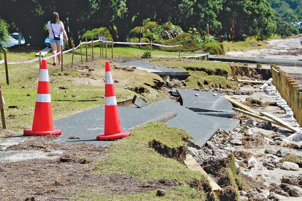
Some of the most dramatic damage was at the usually sheltered Snells Beach, where the wooden seawall was reduced to a scattered pile of planks and the popular waterfront path above it was smashed to pieces in at least two spots. Once the water got in behind the wall, its force snapped the asphalt like a wafer, leaving jagged slabs of pathway and yawning gaps in the surface and grass surrounds.
Further along the beach at Snells, the dune in front of Boathouse Bay looked like a digger had run amok, with the entire front section of sand sliced out to the top, level with the homes just behind it, and taking out a significant section of planting.
It was a similar story at Omaha, where locals woke after the storm to find a new sheer sand ‘cliff’ up to two metres high stretching along four kilometre beach. Pathways were filled in completely or required a considerable jump down to reach the sand, and new waterways were formed by the floodwaters rushing out from soaked reserves and pathways above.

Ruby Cove and Southern Isle residents were again completely surrounded by water, due to even worse flooding than usual in an already troublesome area, where there is an ongoing campaign to remedy persistent ground and stormwater issues.
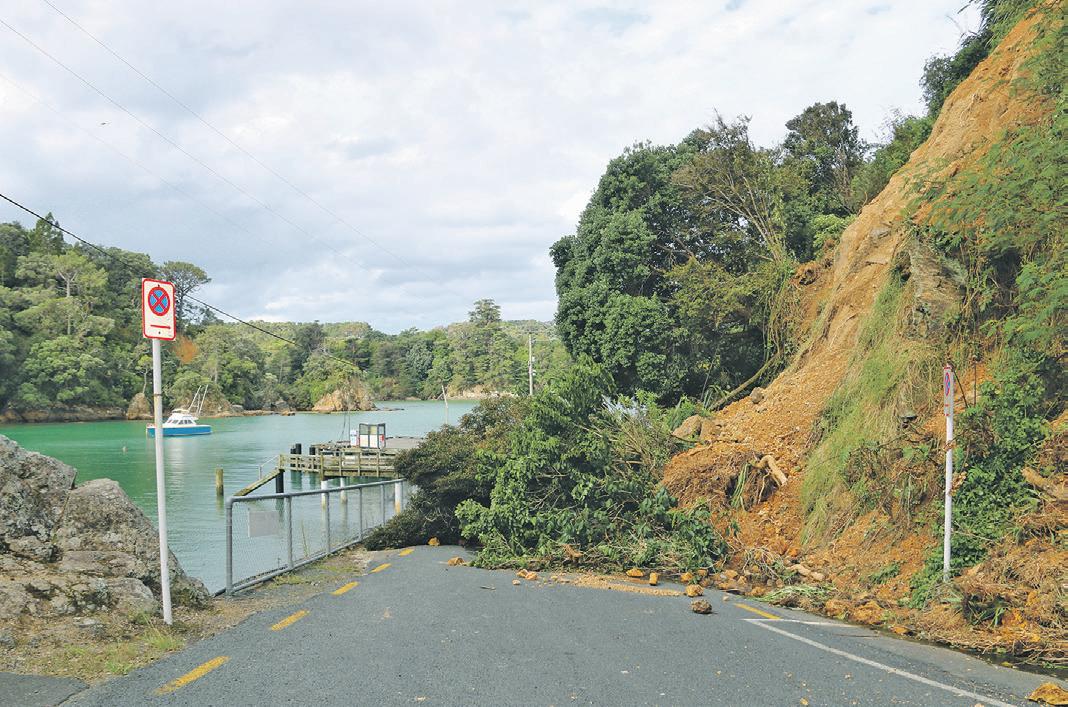
Out at Martins Bay, on the end of the Mahurangi East peninsula, high seas ate into the sandbanks and undermined several sets of steps leading down to the beach. The boat ramp was completely blocked by timber and other debris, while a large slip scarred the cliff to the north of the bay at Scandrett Regional Park. However, it was a different story at Algies Bay, where the sloped stone seawall topped by wooden-fronted terracing was left pretty much pristine, with only a few bits of debris to show that there had been any storm at all.
At Leigh, the harbour was decorated with numerous slips including one that blocked access to the wharf. The harbour walkway was furthered damaged, with stairs missing or broken.
The storm also scoured Mathesons Bay, exposing a rock shelf where the sand used to be. A significant chunk of the foreshore disappeared and bollards were uprooted.
Coastline assessed
Auckland Council says most of Auckland’s coastline has been given an initial inspection, with a focus on known coastal ‘hot-spots’. This has included much of north Auckland’s coastline in the Rodney area, including Snells Beach, Martins Bay, Campbells Beach, Mathesons Bay, Whangateau and Omaha. Additional aerial survey and data capture is also being completed by the geotechnical team. A spokesperson says this information will assist with response and recovery. “We are currently working through the estimated cost of the damage. Outside immediate operational responses to clear debris, this will be determined by the coastal management remediation options that are taken forward.”


School playgrounds disappear
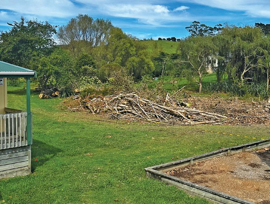
The impacts of the cyclone have been felt far and wide around the region. At Kaipara Flats School, Gabrielle wiped out a favourite playground called ‘The Huts’, a wooded area where the children played, building huts and communities. Principal Debbie Hamer says it was a special place where students had their own economy, community rules and regulations. “It was where their imaginations ran wild and they learned a lot about working and being together,” she says. “During the cyclone, some of the trees in The Hut area were uprooted by the wind so we had to make the call for them to be felled.” The loss of the playground comes close on the heels of the floods, which stripped the playground of the safety cushioning bark and flooded the field, which is now undergoing contamination testing. “Our children are a hardy lot and we will make the best of what we have knowing that others have had it far worse. However, this is our story and we do feel sad.”
Councillors enter uncharted post-storm budgetary waters

By Laura Kvigstad, Auckland Council reporter. Public Interest Journalism funded through NZ On Air.
Auckland Council is trying to come to terms with how it will pay for the January floods, let alone the destruction caused by Cyclone Gabrielle.
At a Planning, Environment and Parks committee on February 9, councillors were worried about how they would pay for the unbudgeted investigation into the Auckland anniversary floods. The investigation will cover the impacts of the flooding, implications of plan changes to the Auckland Unitary plan, infrastructure and policy settings. Cr Daniel Newman said the flooding would have significant budget implications and the scope of Council’s investigation was very broad.
“We are just about to go out for consultation on a budget, which appears entirely theoretical at the moment,” Newman said. He said the budget would need to change as Council managed scarce resources in order to aid recovery.
“I agree with this work, but I think that the scope of it is probably too ambitious.”


